1. Introduction
The lightning discharge process can produce broadband electromagnetic radiation signals ranging from very low frequency/low frequency (VLF/LF) to very high frequency (VHF)/light waves. Depending on the monitoring purpose and requirements, different frequency bands can be adopted to determine the location and time of a lightning discharge based on various methods to monitor the lightning discharge activity.
Lightning discharge radiation energy is mainly concentrated in the VLF/LF band. The signal has a long transmission distance in this frequency band, which is suitable for determining the location of the lightning and monitoring a wide range of lightning activities. Since the late twentieth century, many countries and regions have built commercial cloud-to-ground (CG) lightning location networks based on VLF/LF signals, such as the National Lightning Detection Network (NLDN) in the United States [
1,
2] and the ADTD (Advanced TOA and Direction system; TOA denotes time of arrival) of the China Meteorological Administration [
3]. With the development of electronic technology, a total lightning flash (CG lightning and intracloud (IC) lightning) location system based on VLF/LF signals was also developed [
4,
5,
6,
7,
8,
9]. However, the detection efficiency of discharge events in clouds was still low. Short baseline network layouts and waveform-based location methods are often used in scientific research to achieve higher accuracy and precision in total lightning cloud-to-ground (3D) positioning. For example, the LF near-field interferometric-TOA (time of arrival) 3D Lightning Mapping Array (LFI-LMA) [
10] of Duke University and the fast antenna lightning mapping array (FALMA) [
11] of Gifu University in Japan carry out three-dimensional positioning based on the original signal waveform of the electric field change or magnetic field change.
Although the intensity of VHF signals is lower than that of VLF/LF signals, VHF signals are generated throughout the whole lightning discharge process, resulting in the number of signals far exceeding that of VLF/LF signals. This has also led to more precise positioning technology based on VHF signals. As electronic technology and high-precision timestamp technology have advanced, VHF radiation source location technology has also advanced rapidly. Based on their location algorithms, VHF radiation source location systems can be divided into two categories. The first type is a long baseline TOA location system represented by the lightning mapping array (LMA), and the second type is an interferometric location system represented by interferometers. The LMA was developed by the New Mexico Institute of Mining Technology as a typical three-dimensional location system that uses radiation sources with long baselines. This system records the discharge characteristics of lightning radiation sources through distributed substations. When there are matching records at five or more matching stations, the three-dimensional spatial position and time of the radiation source are determined based on TOA methods [
12]. According to the LMA evaluation results by Thomas et al. (2004) [
13], the horizontal error in the station network of the system is in the range of 6–12 m, and the vertical error is in the range of 20–30 m. The interferometric positioning system calculates the azimuth and elevation based on the phase difference or time difference of the lightning VHF radiation signal to different antennas in the short baseline antenna array to determine the two-dimensional channel of the lightning discharge. Shao et al. (1996) [
14] were the first to develop a lightning VHF broadband interferometer system with a bandwidth of 40–350 MHz. When the signal-to-noise ratio is greater than 10 dB, the location accuracy is approximately 2°. With the advancement of high-speed data acquisition technology, in recent years researchers have begun to develop continuous lightning broadband interferometers [
15,
16]. The synchronous waveforms of multiple antennas are continuously recorded, and the elevation and azimuth are calculated by the TOA method.
In addition to the above monitoring and location technology based on electromagnetic radiation signals, optical observation is an important means of lightning detection. Global lightning flash observations can be realized by loading optical signal detection equipment onto satellites. A typical example of this kind of detection system is the LIS (Lightning Imaging Sensor) system of the United States [
17]. Due to its low observation height, the LIS system has high detection efficiency for total lightning flashes. However, because it employs polar orbiting satellites, thunderstorms can only be observed if occurring when a satellite is overhead. In 2016, lightning monitoring equipment installed on geostationary satellites that can continuously monitor thunderstorm processes was realized in the United States and China [
18,
19].
The development of lightning monitoring and location technology in China is largely in accordance with international advancement. In terms of commercial products, technology has developed from cloud-to-ground lightning location to total lightning flash location. In terms of scientific research, the location of total lightning flashes has become more refined. This paper will discuss the progress of lightning monitoring and location technology in China, including single station locations, low-frequency cloud-to-ground lightning locations, total lightning flash locations, VHF locations, and optical detection technology.
2. Lightning Location Technology Based on VLF/LF Signals
The return stroke in ground lightning flashes is the most common discharge process that generates low-frequency electromagnetic signals. Monitoring and positioning technology based on low-frequency signals is mainly aimed at determining the location of the return stroke, which can be accomplished with single-station or multi-station positioning. Since the beginning of the century, total lightning flash location systems based on low-frequency signals have gradually expanded existing lightning location systems.
2.1. Single-Station Lightning Location Technology
The main goals of single-station location technology are to determine direction and distance. The direction is usually determined based on the response ratio of the orthogonal magnetic loop to the return stroke signal, but determining the distance is difficult with single-station positioning. Single-station location technology in China can be traced back to the 1960s. Zhou et al. (1991) [
20] proposed using the relationship between the phase difference between lightning electric and magnetic signals and their transmission distance for single-station positioning. In 1986, Xiao and Tao (1986) [
21] developed a lightning single-station positioning system with a detection antenna that consisted of a whip antenna and an orthogonal magnetic loop antenna. After they were processed and sampled, the signals received by the antenna were input into a microcomputer for direction finding and distance determination. The distance can be inverted based on the variation law of the phase difference of the electric field and magnetic field with distance during the propagation of the very low frequency/low frequency (VLF/LF) lightning signal in the Earth-ionosphere waveguide, which is the same distance determination method proposed by Zhou (1991) [
20]. However, because the daily variation in the ionospheric height and other influencing factors were not considered, the location results of a single station are not accurate and cannot be used to verify the accuracy of the phase difference method.
Based on the above research, Tao and Zhou (1992) [
22] developed a new single-station detection and location system for lightning (M-LDARS). The antenna consists of a small dipole antenna and an orthogonal magnetic loop antenna placed beneath it. The signals received by the antennas are amplified and filtered by a three-channel receiver (bandwidth: 500 Hz to 350 kHz) before being input into a T0810 transient recorder for signal acquisition and recording. The ranging method was improved further. The relationship between phase and distance can be used for lightning within 140 km, while the time difference between the arrival of the ground wave and the primary sky wave can be used for distances beyond 140 km, and the diurnal variation of the low ionospheric parameters is also considered. Compared with the three-station positioning system, this system can detect the azimuth, distance, polarity, and intensity of the ground flash within a radius of 250 km, and the location accuracy is comparable to that of the three-station positioning system.
In summary, the reliability of the positioning results of a single station depends on the appropriate selection of a propagation mode and low ionospheric parameters. Although there are various methods for calculating the equivalent reflection height of the ionosphere for lightning electromagnetic waves as well as its daily variation, their accuracy is limited, and further research is needed to reduce the uncertain influence of the equivalent reflection height parameters. With the development of multi-station positioning technology and the difficulties in improving distance accuracy in single-station positioning systems, research on single-station positioning technology has not been performed for some time. Since 2010, the Chinese Academy of Meteorological Sciences has developed a lightning electromagnetic integrated detection system for basic lightning discharge signal detection. Based on this, a lightning single-station positioning system with integrated fast/slow antennas and orthogonal magnetic antennas has been developed. The azimuth angle is determined by the change in the orthogonal magnetic field. For return strokes within 50 km, the distance is determined by the ratio of the electric field change signal to the magnetic field change signal at two specific frequency points [
23]. The test results show that the system can determine distances with a high accuracy, with an elevation value of approximately 2 km for triggered lightning at a distance of 8.9 km. Recently, the group has been trying to incorporate artificial intelligence technology into single-station distance determination methods to further improve distance determination accuracy.
2.2. Multi-Station CG Lightning Location Technology
Single-station positioning has the inherent defect of poor positioning accuracy. Although the distance accuracy can be improved by various methods, the overall positioning accuracy still lags far behind that of multi-station positioning. Since the 1990s, multi-station CG (cloud-to-ground) flash positioning technology in China has gradually developed, culminating in the formation of a national ground lightning flash detection network, mainly composed of meteorological and power department positioning systems.
The Advanced TOA and Direction (ADTD) lightning location system is a set of operational lightning location systems constructed by the China Meteorological Administration and operated throughout the country, consisting of more than 400 substations with a baseline distance of 100–200 km, and a station network that spans China (as shown in
Figure 1). The system mainly detects the return stroke of a ground lightning flash with an electric field change antenna with a flat-plate capacitor and an orthogonal magnetic loop antenna. The return stroke signal is identified by an analog circuit, and then a method that combines direction finding and the time difference is used to locate the signal. The detection distance of each substation is approximately 150–300 km. Although many studies use ADTD data to analyze thunderstorm discharge activity in China, an objective evaluation of ADTD performance is rarely included. Many performance evaluations are based on local networks and data, and the results of these evaluations vary. Wang et al. (2018) [
3] evaluated the ADTD positioning system in Beijing and found that the ADTD substation detection range is 260 km. The detection efficiency varies greatly depending on the detection distance from the substations, reaching a maximum value of 86.9% in the range of 60–80 km. The self-evaluation detection efficiency of the whole detection network in Beijing is 85~95%, but the positioning ability for weak current return needs to be improved.
Since the first set of domestic equipment was used in the power grid of the Anhui Province in 1993, after more than 20 years of continuous construction, the lightning location system (LLS) of the power sector in China has formed a national lightning monitoring network that covers the national power grid and most of the land area in 28 provinces and autonomous regions. The structure and positioning method of the positioning network are the same as those of the ADTD. The system integrates an electric field change antenna with a flat capacitor and an orthogonal magnetic loop antenna, and uses a method that combines direction finding with the time difference for positioning. It can monitor the longitude and latitude, discharge time, current amplitude, polarity, number of location stations, and other lightning information. The detection radius of a single station is approximately 100–300 km, and the location error is less than 1 km. Chen et al. (2012) [
24] evaluated the performance of a lightning location system in the Guangdong power grid based on observations of 28 artificially triggered lightning flashes (2007–2011) and 34 natural lightning flashes striking on tall buildings (2009–2011), and found that its detection efficiencies for lightning flashes and return strokes were 94% and 60%, respectively. The arithmetic mean value of the positioning error was 710 m, and the mean deviation between the current obtained by the positioning system and the current directly measured current of triggered lightning is 16.3%.
2.3. Total Lightning Location Technology Based on VLF/LF Signals
Although the national cloud-to-ground (CG) lightning location system has played an important role in the analysis of thunderstorm lightning activity in different regions of China since its inception, its monitoring and location systems are only aimed at return strokes (RSs), which provides very limited discharge information. With the development of electronic technology, lightning monitoring and location technology is transitioning from RSs to total lightning flashes in the 21st century.
Research on total lightning flash positioning technology based on VLF/LF signals in China began in scientific research departments, and the technology adopted was similar to the Los Alamos Sferic Array (LASA) system in the United States [
8]. In general, no fewer than five stations of fast electric field detection arrays are used as sensors. The time-of-arrival (TOA) method is used to locate lightning in three dimensions (3D) based on the time and amplitude of the pulse peak. Compared with traditional CG lightning location systems, total lightning flash detection systems based on fast electric field arrays can locate not only RSs but also discharge processes in clouds. The positioning details of such systems differ slightly between research groups. In 2004, CAREERI (Cold and Arid Regions Environmental and Engineering Research Institute, Chinese Academy of Sciences) built a fast electric field change detection array with seven substations in Zhongchuan, Gansu Province [
25]. In the positioning process, the original pulse waveform is converted into a power waveform for automatic peak searching, and the time difference between the substations is used to select the peak value and time that satisfies the conditions. The location of the radiation sources is determined with the TOA technique. When compared with radar echo results, the reliability of the positioning was confirmed [
25]. Although the method can accurately locate discharge processes in clouds, because only the amplitude and time difference are used in peak searching and matching, there are problems with incorrect and ineffective matching when there are many pulse signals, resulting in large positioning errors. Therefore, the algorithm needs to be further improved. Subsequently, Dong et al. of the Chinese Academy of Meteorological Sciences developed a lightning detection system with nine substations based on VLF/LF signals in Chongqing in 2010 [
26]. The fast electric field change signals of each substation were digitized with a data acquisition card at a sampling rate of 2 MS/s and stored in a computer. The 3D position of the discharge was calculated using the TOA technique. At the same time, three discharge types were identified based on their waveforms: intracloud (IC) lightning flashes, CG lightning flashes, and compact intracloud discharges.
The LF electric field detection array (LFEDA), a similar but redesigned system, was developed by Zhang Yang and Zheng Dong in 2014. The detailed technology and development process of the LFEDA can be found in Zhang et al. (2021) [
27]. The LFEDA was composed of 10 fast antenna detection substations with high sensitivities that were installed in the Conghua District of Guangzhou. Methods similar to those discussed above were used for positioning based on the original waveform data, and a positioning accuracy of 100 m was achieved after evaluating the triggered lightning flashes. As shown in
Figure 2, the LFEDA has channel positioning capabilities for some lightning flashes [
28]. Based on this system, the team has continuously refined the localization algorithm and made significant progress in improving localization precision.
The Beijing Lightning Network (BLNET) was established by the Institute of Atmospheric Physics, Chinese Academy of Sciences in 2008 [
29]. The number of substations increased to 10 in 2013, with each substation containing a fast antenna, a slow antenna, and a VHF antenna, the signals of which were digitized by a microprocessor with a built-in acquisition card. One-second waveforms are recorded with this system. Based on fast electric field change data, total lightning flash positioning is performed by combining Chan’s algorithm with the Levenberg–Marquardt algorithm. The positioning results are consistent with the radar echo characteristics at the corresponding time. The hardware, station network layout, and location algorithm were updated in 2015 [
30], which improved the sensor sensitivity and the software computing efficiency. The upgraded BLNET realizes 3D real-time localization of radiation source pulses by using the TOA method. A lightning observation network with a hybrid baseline in the Jianghuai region was established by the University of Science and Technology of China [
31]. The network uses an antenna similar to that of a single-station positioning system to receive signals, then uses a microprocessor to digitize and extract the time and amplitude information from pulse peaks in real time, and finally determines the total lightning flash position with the GPU (Graphics Processing Unit) method. Based on the observation data, an ionospheric characteristic inversion method was developed to study middle- and high-level discharge laws and ionospheric characteristics.
In terms of commercial systems, the China Meteorological Administration also upgraded the ADTD lightning location system, removing the analog circuit identification component of the original system while keeping the sensor unchanged. In addition, all signals detected by the antenna were output to a field programmable gate array (FPGA). As a result, the IC flash detection capability was expanded. Finalized products are becoming more popular and widely used all over the country [
32]. The performance of this system has been evaluated by triggered lightning, and the detection efficiencies of CG lightning flashes and RSs are 100% and ~63%, respectively. The average positioning error of RSs is approximately 464 m, and the current error is 11.49%. By comparing these results to the total detection results of the LFEDA used in scientific research, the total lightning detection efficiency of the system is 50%.
2.4. Total Lightning Precision Location Technology Based on VLF/LF Signals
Since 2010, total lightning precision positioning technology based on VLF/LF signals has become popular. To further improve the precision positioning ability, different research groups have used various technical schemes to achieve their goals. In general, two factors can be used to improve the precision positioning capability: hardware and positioning methods. In terms of hardware, the sensor can be upgraded to detect richer pulses, which is beneficial for improving positioning precision. In terms of positioning methods, positioning methods based on waveforms can improve precision.
For the determination of the total lightning location based on a fast electric field array, although the TOA method can achieve high-precision location results under good signal conditions, the precision and accuracy of the location are greatly affected by the pulse matching ability and pulse time accuracy. During the positioning process, high-frequency noise in the low-frequency signal reduces the accuracy of the pulse peak time, and complex signal components may weaken the matching ability of the pulse signal. To address this problem, the lightning group of the Chinese Academy of Meteorological Sciences [
33] used empirical mode decomposition (EMD) signal processing technology to process the early-stage multi-station waveforms of the LFEDA, achieving LF signal filtering and high-frequency noise reduction. Based on the processed waveform, waveform correlation matching was carried out by gradually reducing the waveform window, and the traditional TOA method was used to find the optimal solution. Compared with LFEDA location determination based on simple pulse feature matching [
28], this method improved the location precision. Under the same output constraints, 2296 points were located for the same example in
Figure 2. In addition, based on the long-time series (1.2 s) waveform data of broadband fast electric fields observed by the multiband lightning observation network of the Cold and Arid Regions Environmental and Engineering Research Institute, Chinese Academy of Sciences, the Pearson correlation method and the empirical mode decomposition (EMD) method were combined for lightning discharge field pulse matching, which resulted in precision channel positioning [
34].
For the VLF/LF signals of lightning discharges at greater distances, the transmission paths to different detection stations and the electromagnetic environment of different detection stations are significantly different. There are clear differences in the signal-to-noise ratio, phase, amplitude and waveform features of the lightning signals, resulting in incorrect pulse matching and low peak time accuracy. To solve these problems, the lightning team of the Chinese Academy of Meteorological Sciences [
27,
35] developed a location algorithm that combines time reversal and TOA. The basic principle is as follows. The lightning radiation signal waveform received by each antenna is transmitted to free space at the antenna position after time reversal (called the time reversal signal). During the propagation process, the time reversal signal is superimposed at various positions in space, until the peak appears at the radiation source position. This method, which does not require complex signal processing, can produce positioning results of comparable quality to the waveform postprocessing method. Moreover, this method can obtain richer and more accurate positioning results with four station signals, even with a poor signal-to-noise ratio and a low time accuracy, which is beneficial for determining the position of actual long-distance weak signals (low signal-to-noise ratio signal) and low time accuracy signals.
The abovementioned refinement localization methods are based on the original signal waveforms and use postprocessing. The positioning speed is slow; thus, it is difficult to meet the real-time requirements of commercial systems. Therefore, the lightning group of the Chinese Academy of Meteorological Sciences introduced artificial intelligence (AI) technology into lightning location systems based on a low-frequency electric field detection array, and proposed a fast and precision positioning method based on lightning pulse features [
36]. In this method, an AI-based lightning signal convolution automatic encoder is used to extract pulse signal features to improve the matching ability. The pulse signals from multiple stations are matched based on the above features, and the matched signals are positioned by TOA technology. As shown in
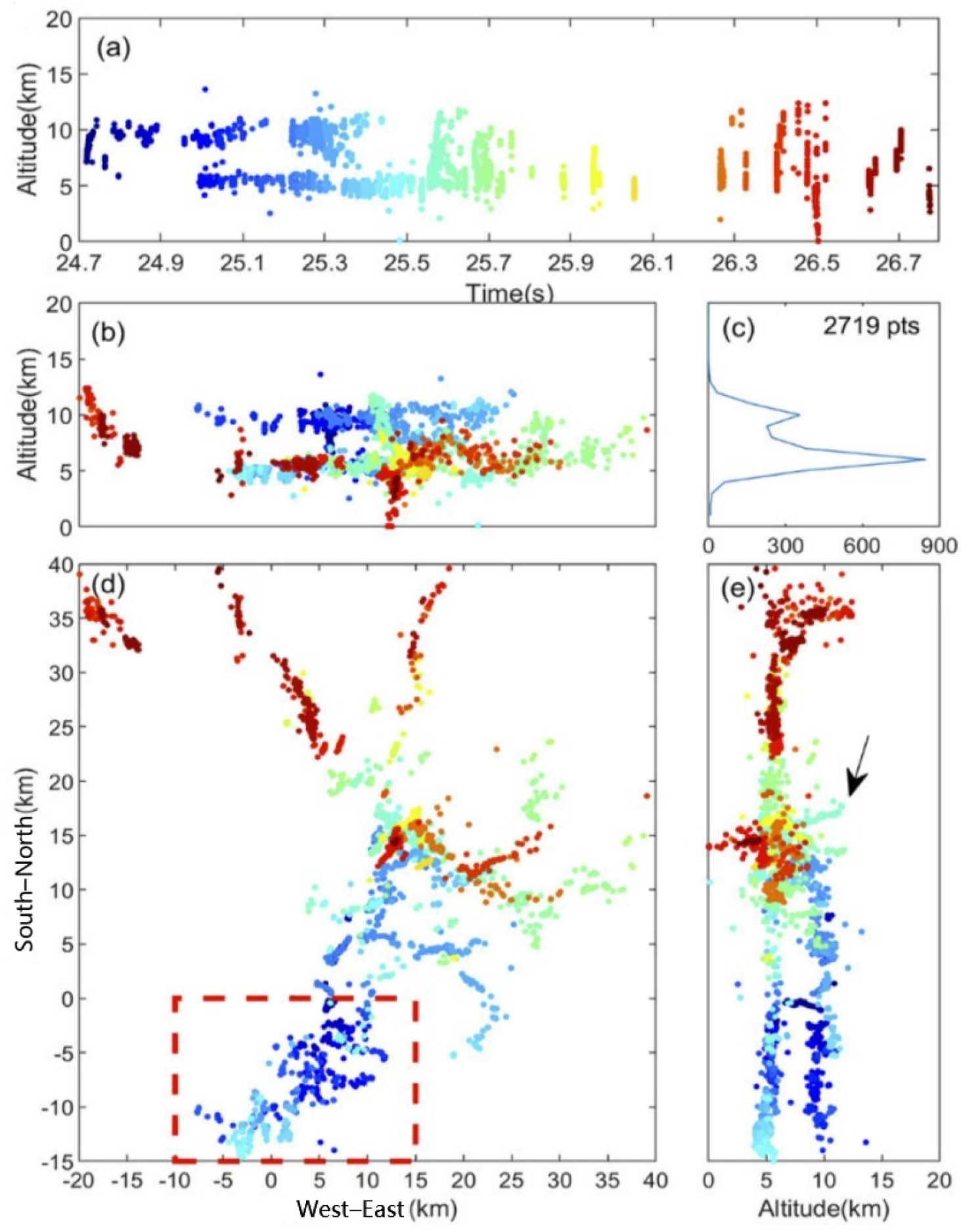
Figure 3, this method has a high degree of positioning precision, with as many as 2719 positioning points for the example in
Figure 2. Moreover, when compared with other lightning location methods used in the LFEDA, the matching efficiency is increased by more than 50%, significantly improving the positioning speed. Furthermore, this method maintains high-quality positioning even when the signal-to-noise ratio is low. Based on the evaluation of triggered lightning, the detection efficiency of the system using this method is 99.17%, and the positioning accuracy is approximately 100 m.
Furthermore, to meet the dual demands of commercial activities and scientific research, Zhang et al. (2021) [
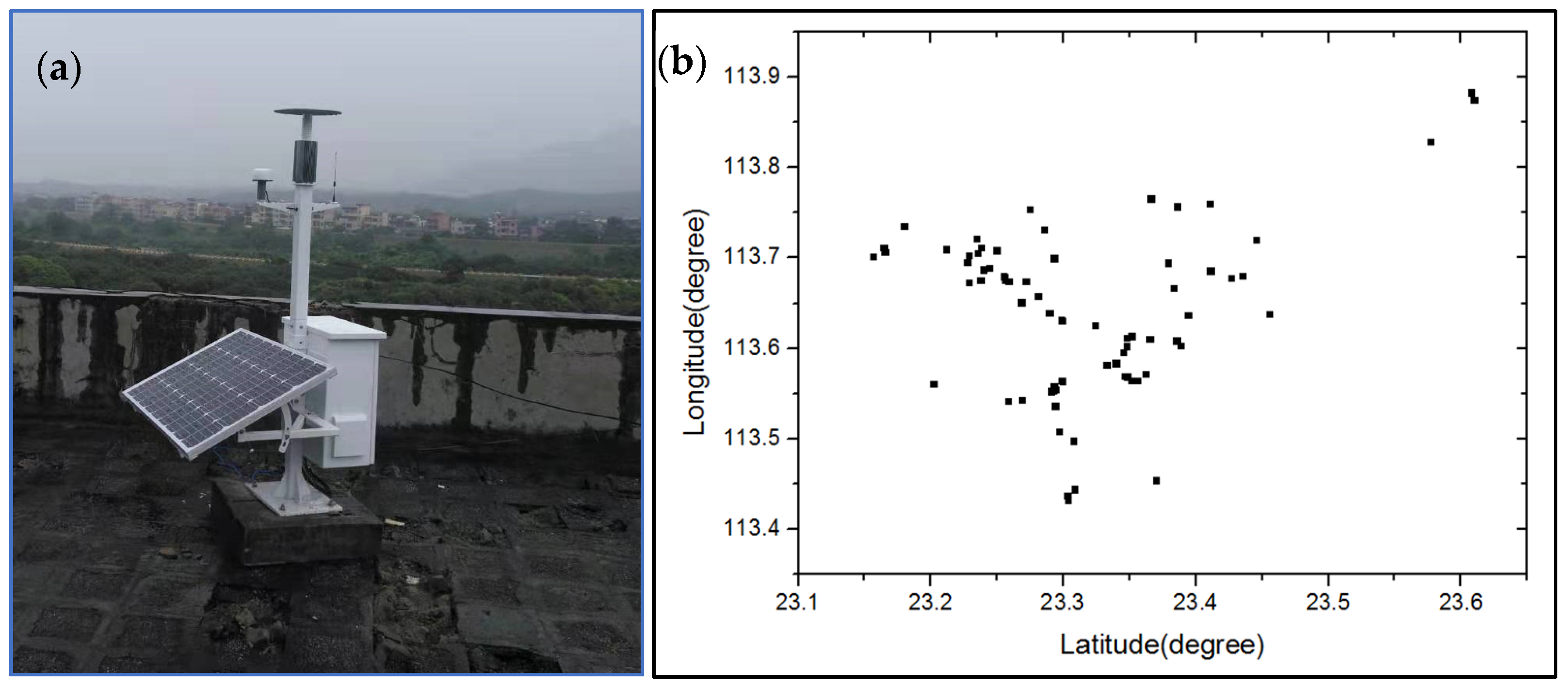
27] of the Chinese Academy of Meteorological Sciences upgraded the original LFEDA hardware. A new generation of low-power real-time detection substations based on FPGA real-time signal processing technology that are powered by solar energy with a power consumption of 10~24 W was developed, as shown in
Figure 4. Each substation can be used to extract discharge signal features and has the capability of storing the original waveform. The pulse features of the substation are transmitted to the cloud center station in real time, and a TOA or GPU three-dimensional algorithm is used for real-time positioning and display. This has led to the development of a real-time total lightning positioning network based on LF signals: the real-time LF electric field detection array (RT_LFEDA), which also has some channel mapping capability (see
Figure 4b) [
27].
In addition, the Institute of Atmospheric Physics of the Chinese Academy of Sciences developed precision positioning technology [
37] on the basis of the original BLNET, and a three-dimensional LF lightning location network with eight stations was established in Binzhou, Shandong Province. The system uses three kinds of antennas—dE/dt, fast electric field and slow electric field—and carries out synchronous acquisition through a spectrum multichannel data acquisition card. To achieve both recording efficiency and continuous storage, the ABA acquisition mode was used. As a double time-based digital acquisition mode, it combines the fast acquisition of trigger events (B time-based) with continuous slow acquisition (A time-based). Based on waveform postprocessing, the TOA localization algorithm was combined with particle swarm optimization (PSO) for positioning, which has channel positioning capability for some lightning, and the average horizontal positioning accuracy, as evaluated by triggered lightning, was approximately 105 m.
3. Lightning Location Technology Based on VHF Signals
Compared with low-frequency signals, lightning VHF signals are mainly generated by breakdown discharge, which is accompanied by the extension process of the whole lightning channel. Therefore, lightning detection and location based on very high-frequency (VHF) signals can be used to describe the lightning channel. Currently, VHF location technology is divided into two main categories: interferometer location technology and time of arrival (TOA) location technology. In VHF/TOA location technology, the three-dimensional spatial position of the discharge is calculated based on the time difference between the lightning radiation signals that reach different distributed antennas. VHF interferometer location technology mainly uses interferometry to measure the elevation and azimuth of the radiation source. Based on the detection spectrum ranges and hardware compositions, VHF interferometer location technology can use either narrowband interferometers or broadband interferometers.
3.1. Narrowband Interferometer Location Technology
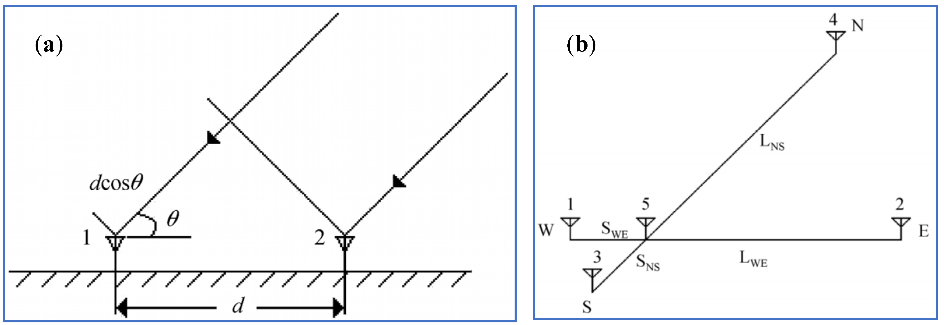
As shown in
Figure 5a, the simplest narrowband interferometer is composed of two narrowband antennas separated by a distance d (generally several meters to tens of meters). The long-distance radiation signal is regarded as a plane wave, and the phase difference between the signals received by the two antennas can be calculated by
, where
is the wavelength of incident wave,
θ can be determined based on the measured
value. The periodic change in the angle is typically handled by multibaseline cooperation (defuzzification), and
can be obtained based on the difference in the spectral response between the two antennas. Based on the above principle, Zhang et al. (2008) [
38] developed a narrowband interferometer location system with five antennas arranged in an orthogonal array with both long and short baselines (as shown in
Figure 5b). The signal received by the antenna has a center frequency of 280 MHz and a 3 dB bandwidth of 6 MHz. The signal from antenna 5 is used as a reference, and the signals from the other four antenna interfere with the reference signal to determine the position. The length of the long baseline is four times the wavelength of the received signal, leading to an accurate location result, but with fringe ambiguity. The length of the short baseline is half the wavelength, resulting in a large location error, but with no fringe blur. To improve the processing speed, the system uses a hardware circuit to realize phase detection of a multichannel signal and transforms high-frequency signals into low-frequency phase signals, which reduces the sampling rate and data storage capacity requirements of the recording equipment. The system can continuously calculate the elevation and azimuth of lightning radiation sources with a time resolution of 1 µs, and the average location error of the indoor calibration is less than 1 degree. When the high-speed acquisition and recording capacity is insufficient to support the acquisition of more than 1 s of multichannel data, the system continuously determines the location of the lightning discharge radiation sources.
Although the narrowband interferometer based on the above principle can easily obtain the phase difference, the narrowband interferometer cannot determine the location well when multiple radiation sources occur at the same time. To further improve the performance of narrowband interferometers, Zhang et al. (2003) [
39] developed a narrowband interferometer system using the TOA method (also known as the short baseline TOA location system). The system includes four dipole antennas, a high-speed data acquisition system, transient waveform recording equipment, a fast and slow antenna, a lightning recording trigger instrument, a General Purpose Interface Bus (GPIB) data interface, and a microcomputer. The time difference between the signal and the different antennas, as well as a simple geometric method, were used to locate the discharge radiation source, and the elevation location error was less than 3 degrees. Although field observations verified the ability of the system to locate lightning leader processes and radiation sources generated by cloud lightning, the location elevation error was relatively large due to a lack of in-depth research on the time difference calculation method, and the effective detection distance was small.
3.2. Broadband Interferometer Location Technology
Broadband interferometers generally use VHF broadband antennas. The elevation and azimuth of the radiation sources can be calculated by determining the phase difference between the spectral components of the radiation signals that reach the broadband antennas. The principle is illustrated in
Figure 5a. The simplest broadband interferometer system consists of two broadband antennas separated by a certain distance. The phase difference between antenna 1 and antenna 2 is
, where
is the frequency,
is the incident angle,
is the speed of light, and d is the distance between the antennas. After fast Fourier transform processing the time-domain signals received by the two antennas, the phase difference spectrum of the signals can be obtained, and the incident angle of the radiation signals to the antenna can be determined with the above formula. The broadband interferometer system is usually composed of three antennas, with two baselines remaining vertical (orthogonal baseline). The azimuth and elevation of the corresponding radiation sources can be obtained with a simple spherical calculation. In essence, this system is equivalent to a narrowband interferometer system with multiple baselines of different lengths. It can provide the position of radiation sources in the form of an azimuth and elevation, and has the ability to locate multiple radiation sources at the same time.
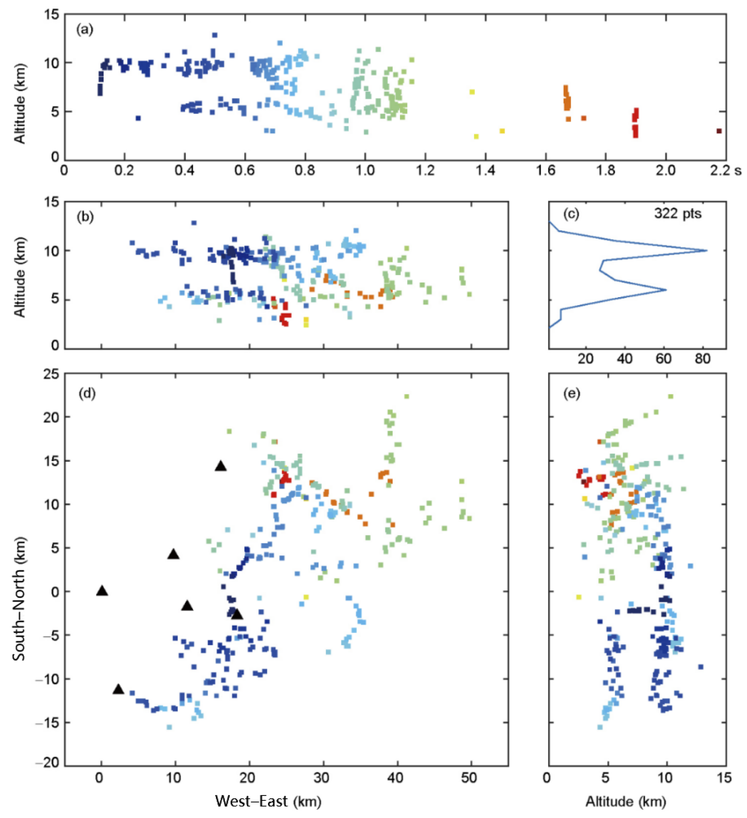
Dong et al. (2001) [
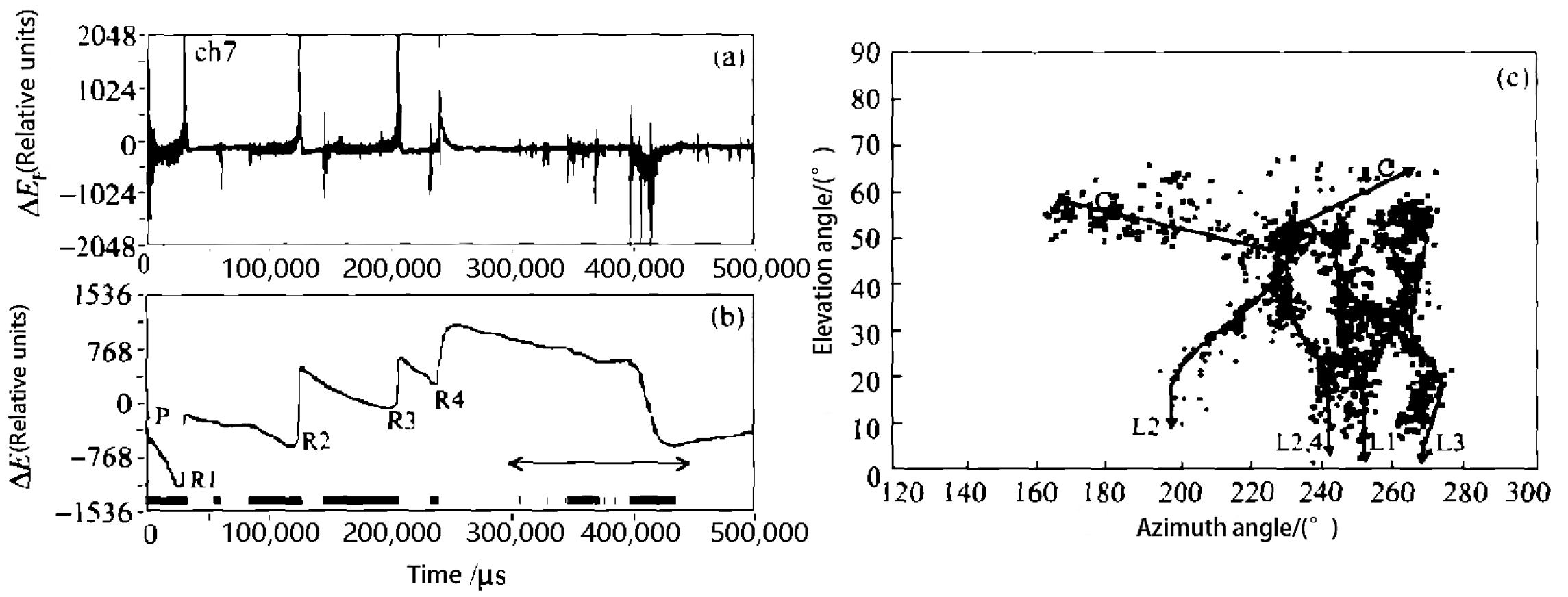
40] developed a broadband interferometer system based on the above principles. The system consists of three VHF receiving antennas, fast and slow antennas, a data acquisition card, a four-channel oscilloscope, and a microcomputer. The antennas are arranged in an isosceles right triangle with a side length of 10 m. The antenna output signals are filtered and input into the oscilloscope, and the multisegment mode is used to digitize and record the radiation signal. The radiation source location calculation method is similar to that of Shao et al. (1995) [
41], but the frequency band in which the phase difference varies linearly with the frequency across the whole frequency range was selected to calculate the approximate incident direction of the radiation signal, and a higher frequency component was used to obtain a more accurate incident direction. Based on the observation results of the system under multi-return strokes (RS) lightning, the system can better determine the structure of the lightning channel, as shown in
Figure 6. However, due to the limited memory of the oscilloscope, only a limited number of lightning discharge signal segments can be triggered and recorded. Therefore, omission-free positioning of the whole lightning discharge process cannot be realized.
Although broadband interferometers can locate multiple radiation sources at the same time, their wide frequency bands make them vulnerable to interference from natural noise during the measurement process, which affects the measurement accuracy. Due to the influence of noise on the direction-finding accuracy of broadband interferometers, some researchers have improved the data processing method and location algorithm of broadband interferometers. Qiu et al. (2009) [
42] used time-domain cross-correlation technology to determine the radiation source location with broadband interferometers and proposed the cross-correlation angle measurement algorithm. The observation of the leader and subsequent return stroke process in triggered lightning showed the accuracy and anti-interference capability of the method. Since 2010, this kind of method has been widely used for interferometers. Cao et al. (2012) [
43] used hardware similar to Dong et al. (2001) [
40], and broadband radiation signals with bandwidths of 125–200 MHz, but they used a correlation time delay algorithm to determine the location, which improved the location accuracy and had an elevation error of less than 1 degree. Based on observations, they analyzed some typical discharge processes of cloud flashes and ground flashes in the Daxinganling region of Northeast China. To further improve the location results of broadband interferometers, based on the research of Cao et al. (2012) [
43], Sun et al. (2013) [
44] proposed a generalized correlation time delay calculation method based on direct correlations and wavelet transforms. To reduce noise and improve the accuracy of the time delay estimation, a parabolic interpolation algorithm was used. The location results of this method are in good agreement with high-speed camera images and can effectively locate lightning radiation sources in two dimensions. In addition, Zhou et al. (2013) [
45] improved the traditional generalized cross-correlation time delay estimation algorithm with quadratic correlations. Simulation experiments showed that the performance of the new algorithm was significantly better than that of the generalized cross-correlation algorithm.
3.3. Continuous Interferometer Location Technology
Although broadband interferometers have the advantage of multisource locations, they require high-speed acquisition and storage at sampling rates of hundreds of MS/s or even 1 GS/s. Due to onboard memory limitations, it is often impossible to record a lightning process completely and continuously, and a multisegment recording mode can only be used to record limited signals. Furthermore, the multisegment recording mode cannot record weak signals below the trigger level, resulting in the loss of some weak discharge information.
To solve the above problems, some domestic scientific research institutions have developed a continuous interferometer system based on a broadband interferometer that has greater continuous recording capability, as well as the corresponding location algorithm. Zhang et al. (2017, 2018, 2020) [
16,
46,
47] of the Chinese Academy of Meteorological Sciences developed a continuous interferometer system in which three VHF broadband disk cone antennas are arranged in an equilateral triangle with a side length of 20 m. After filtering, the signals of these antennas are transmitted to an acquisition and recording device through a low-loss coaxial line for synchronous continuous acquisition. The sampling rate of the system varied from 200 MS/s to 400 MS/s during different years, and the sampling length was 2 s in the first year and was increased to 4 s in 2017. The elevation and azimuth are calculated based on the obtained synchronization signal with the correlation time delay method. The location time resolution varies with the window size, realizing high-precision positioning with a maximum resolution of 0.16 microseconds and continuous location determination throughout the whole lightning discharge process. Based on the observation and location results of triggered lightning, some new insights into the physical processes of lightning initiation, leader development, return stroke and the M component have been obtained.
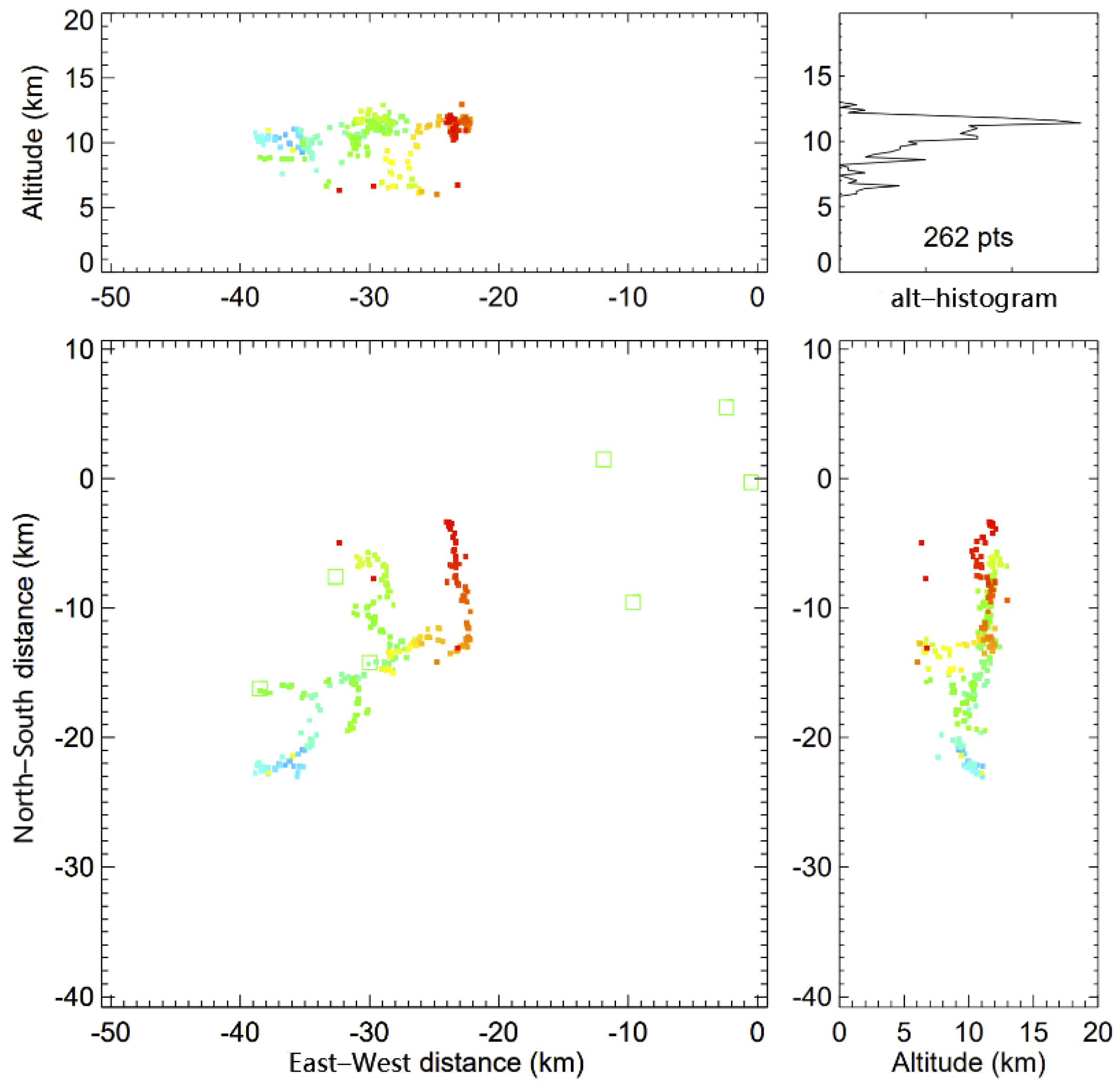
Figure 7 shows the continuous observation and precision location results of the system for the whole initiation process of artificially triggered lightning. The system not only has the ability to continuously describe the lightning channel structure, but also has good resolution ability for small-scale discharge processes.
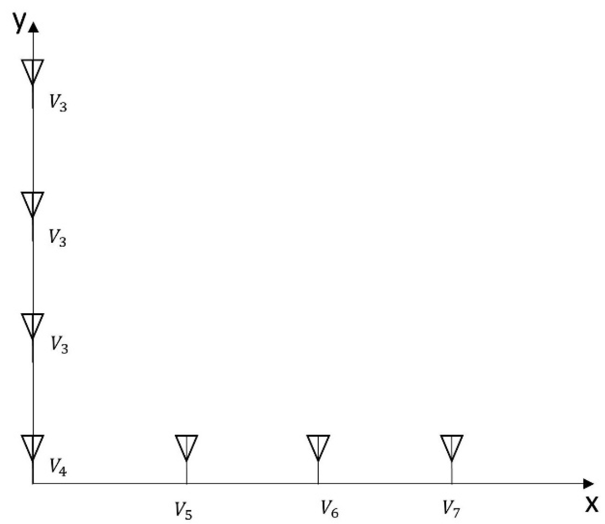
Based on a broadband interferometer with an intermittent recording mode, Sun et al. (2014) [
48] realized the long-term continuous acquisition and recording of multichannel radiation signals by upgrading the acquisition system. The longest recording length is 1 s, which can essentially realize continuous location determination throughout the whole flash discharge process. Based on system observations, triggered lightning discharges with multi-return strokes were studied in detail, and the leader and initiation characteristics of the multi-return stroke were revealed. Wang et al. (2017, 2020) [
49,
50] also investigated the location method of continuous interferometers. Similar to the method of Stock et al. (2014) [
51] that used multiple baselines to improve the performance of interferometers, as shown in
Figure 8, 7 antennas were used to build an interferometer in an “L” shape (also called a continuous VHF imaging array). Based on this system, some new location algorithms, such as EMTR (electromagnetic time reversal) [
49] and MUSIC (multiple signal classification) [
50], were discussed, which improved the location precision of traditional continuous interferometers, especially for weak radiation signals.
3.4. VHF Lightning Location Technology with Long Baselines
The VHF/TOA location technique calculates the spatial location of the radiation source based on the time difference between the arrival of the radiation signal at different stations in the detection network. Based on the length of the baseline, the locating technique can be divided into two types: long baseline TOA location and short baseline TOA location. The short baseline VHF/TOA location technique is often used in interferometer systems; it was discussed in the interferometer section and will not be described in detail here.
The long baseline VHF/TOA location technique is commonly used for monitoring thunderstorm activity over large areas. With the development of high-precision GPS/BD technology, the absolute arrival time of radiation pulses at measurement stations can be accurately determined; thus, pulse discharge events can be precisely located. The specific long baseline TOA location method is as follows: the time ti when the lightning radiation pulse that occurred at time t reaches Station i is , where (x, y, z) is the spatial position of the radiation source, (xi, yi, zi) is the spatial position of the ith station and c is the speed of light. When n stations are used for measurements, n equations for ti can be obtained, forming a nonlinear equation group, and the position of the radiation source can be determined by the nonlinear least square method.
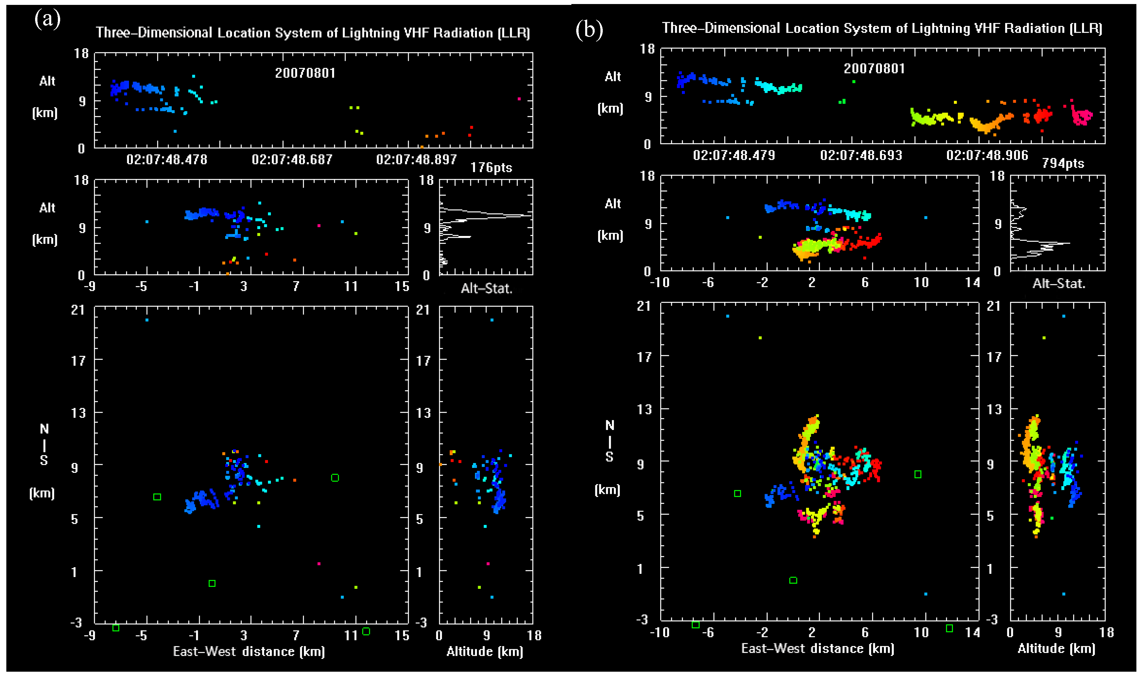
Zhang et al. (2010) [
52] developed a long baseline 3D lightning location system (LLR) for scientific research, similar to the system in Rison et al. (1999), but with a higher frequency narrowband signal. The system consists of seven substations that have a central frequency of 270 MHz and a bandwidth of 6 MHz. The received signal is fed into an acquisition card in a microprocessor, the maximum peak signal is acquired at 25 μs intervals by triggering, and the intensity and time of the signal are recorded at the same time. Based on the absolute arrival time of the signals from different substations, the TOA method can be used to locate the lightning radiation source in three dimensions. The system can monitor the whole thunderstorm discharge activity process [
53] and has the ability to locate the discharge channel, but the convergence of the channel is not high. To improve the location capability, Wang et al. (2012) [
54] analyzed the possible sources of location error for this location system and found that the GPS timing error, the substation position error, and the accumulation of board crystal oscillator frequencies were the main hardware errors. After the error correction, the LLR provided better location results, with lightning channel positioning with greater height convergence and an improved detection efficiency (
Figure 9). Zhang et al. (2015) [
55] evaluated the accuracy of this location system in Qinghai by using a homemade sounding ball-borne lightning simulation source, yielding an average error of 21 m (RMS) for horizontal positioning and 49 m (RMS) for vertical positioning within the positioning network.
In addition, the Chinese Academy of Meteorological Sciences developed a dual-band location system based on the TOA technique [
56,
57] and conducted scientific observation experiments in Chongqing. The system operates in the VLF/LF and VHF frequency bands. The signals received by the VLF/LF and VHF antennas were output to an acquisition system after being conditioned by their respective receivers. The acquisition system used a microprocessor to control the acquisition card for segmental trigger acquisition to further extract the pulse characteristics. The system can perform 3D positioning based on the TOA method, identify lightning discharge types, and provide polarity and intensity information. In the past two years, the system has been redeployed to the Jiangsu Province, and is now operated by the lightning team of PLA Army Engineering University. Based on the current precision positioning method for low-frequency total lightning, Liu et al. (2020) [
58] significantly improved the precision positioning ability by postprocessing the original waveform. However, this postprocessing positioning method cannot meet the needs of real-time precision positioning. Improving the real-time precision positioning ability of VHF positioning systems is an urgent problem that must be addressed.
A lightning mapping array (LMA) was developed by Yang Zhang and Yijun Zhang of the Chinese Academy of Meteorological Sciences from 2018 to 2020. The array (called GD_LMA) was deployed in the Guangdong Province; the longest baseline was 60 km, and the shortest baseline was 3 km. The array covered a 100 km area around the Conghua district and operated at a center frequency of 193 MHz and a bandwidth of 6 MHz. The layout of the station network takes into account the observation needs of large-scale thunderstorms and weak triggered lightning to a certain extent. The preliminary observation results confirmed the detection capability of the network. As shown in
Figure 10, for a lightning flash occurring near the station network, the number of locating points is limited, but the array can clearly depict the lightning channel.
4. Satellite-Based Lightning Optical Monitoring Technology
Lightning discharge produces strong optical radiation, with the strongest near-infrared absorption spectrum at 777.4 nm, which can be observed from space by cameras. The United States has been at the forefront of satellite-based optical imaging lightning observations. Following the LIS (lightning imaging sensor) lightning observations carried by polar orbiting satellites, the United States launched the Geostationary Lightning Mapper (GLM), carried by geostationary satellites, in 2016. At approximately the same time, China launched a new generation geostationary satellite, Fengyun-4 (FY-4A), on 11 December 2016 [
18]. This satellite was equipped with the independently developed Lightning Mapping Imager (LMI), which is similar to the GLM in terms of design performance, filling a gap in the field of space-based lightning detection in China.
The LMI observes lightning discharge luminous channels with a charge-coupled device (CCD) with a size of 400 × 600, a detection center wavelength of 777.4 nm, a bandwidth of ±1 nm and a shooting speed of 2 ms/frame [
59]. The spatial resolution of the subsatellite point is 7.8 km, and the high frame rate ensures that the LMI can capture a complete lightning discharge process. When the irradiance of the lightning light radiation detected by a single pixel of the CCD array of the LMI exceeds the background threshold, it is defined as a lightning “event”. Lightning events detected by multiple adjacent pixels on the same CCD image form a “group”, and multiple groups that meet certain threshold conditions are defined as a true “lightning” process. Cao et al. (2021) [
60] investigated the optical characteristics and distribution of events, groups, and flashes observed by the LMI across the entire observation domain in China. The duration and brightness of lightning flashes are usually less than 50 ms and 200 Jm
−2ster
−1µm
−1, respectively. The coverage area of lightning flashes ranges from 200 to 600 km
2. The number of groups for each flash was typically less than five, and the detection efficiency of the LMI was higher at night than during the day. Compared with the lightning imaging sensor on the International Space Station (ISS-LIS), the number of flashes detected by the LMI and the duration of each flash are smaller. Compared with the CG lightning location network (LLNC) in China (shown in
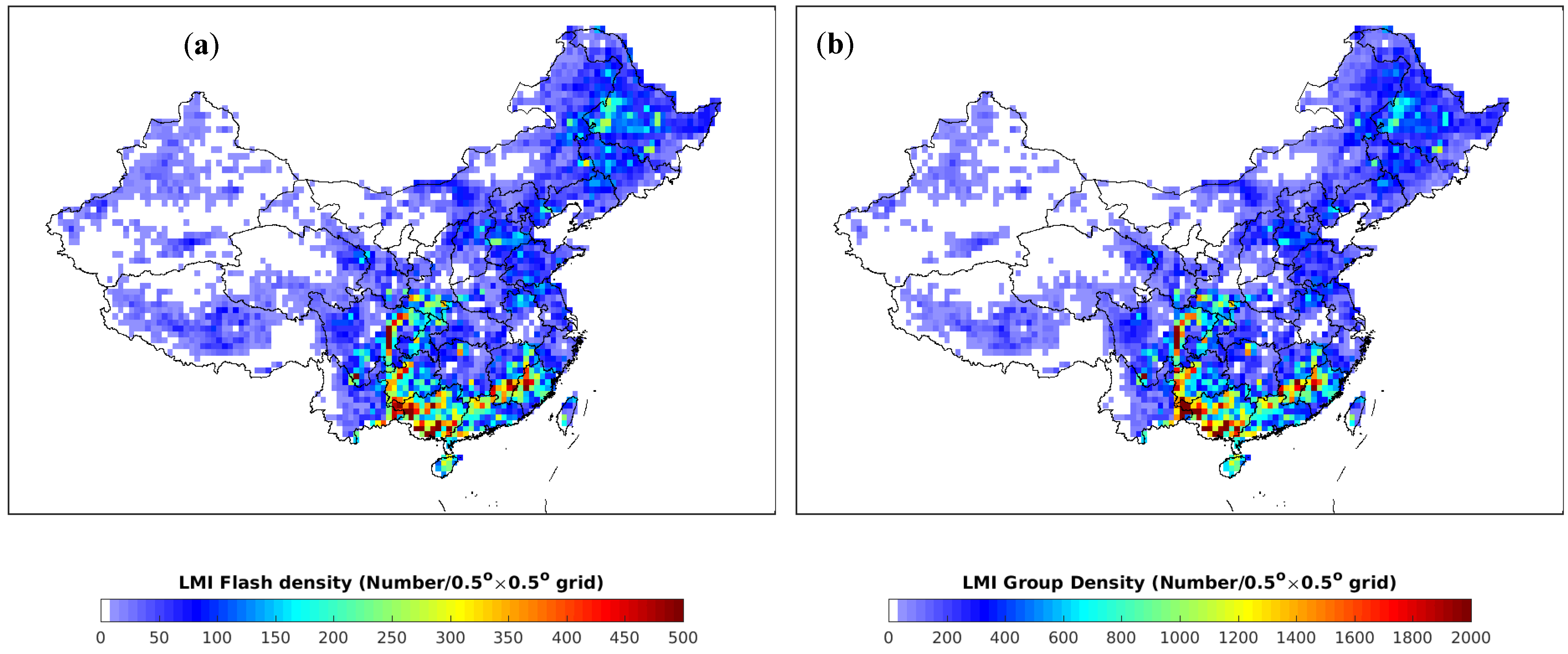
Figure 11), the number of groups detected by the LMI was similar to the number of CG lightning events, and the high-value area of the lightning density was roughly the same.
At present, some articles have reported comparison results between the LMI and other location systems [
61,
62,
63], but the comparisons are mostly based on the results of large-scale, long-term overall lightning activity distributions, giving the consistency of its distribution relative to radar echoes and other CG flash location systems. However, true evaluations of the detection efficiency of CC flashes and cloud flashes detected by the LMI are still in progress.
5. Conclusions and Discussion
Lightning monitoring and location technology in China has closely followed international standards and has gone through several developmental stages, from low-frequency monitoring to very high-frequency (VHF) signal monitoring, single-station locations to multi-station networking positioning, and ground-based remote sensing to satellite-based optical observations. The positioning accuracy and precision are both increasing. The location capability has also evolved, from initially determining the two-dimensional return stroke location to the current determinations of the three-dimensional total-flash location, and new technologies for very low-frequency/low-frequency (VLF/LF) and VHF locations are being developed to efficiently determine total-flash locations and improve the channel location capability.
In terms of single-station positioning, although synchronous detection technology based on electromagnetic signals has developed a segmental ranging method based on the phase difference-distance relationship of electromagnetic wave propagation within 140 km and the time difference of sky waves and ground waves over a long distance, it is difficult to further improve the location accuracy. Furthermore, single-station positioning mainly uses the return stroke of the cloud-to-ground (CG) flash. However, as total-flash locations have gradually become more popular, the disadvantages of single-station positioning have become more obvious, and it is mainly suitable for places with low requirements for positioning accuracy and difficulty obtaining networking positioning.
In terms of VLF/LF multi-station locations, China has gradually established a national CG flash location network since the beginning of the 21st century, which has played an important role in understanding thunderstorm lightning activity. Currently, with the advancement of technology, international commercial lightning detectors have entered the total-flash stage. China has a relatively mature scheme for determining total-flash locations based on VLF/LF signals in both the scientific and commercial fields. However, while the total-flash location network, which is currently being upgraded nationwide, has a high flash detection efficiency, it has a low location efficiency for the discharge events in each flash, especially for long-baseline layouts. The three-dimensional height location error is still large and needs to be addressed by developing new technologies, such as more sensitive sensors, more refined location methods, and shorter baseline station networks. In the field of scientific research, although some research groups have conducted research on precision location technology based on VLF/LF signals, the precision method is still based on post waveform processing, which has a slow positioning speed and a low real-time degree. Furthermore, most studies only have channel location capability for some flash cases. Therefore, developing methods and technologies that can accurately locate most lightning discharges in real time is an important direction of total lightning detection research based on VLF/LF signals in China.
In terms of VHF location, due to the small detection range and large number of substations required, a commercial product using VHF-location technology has yet to be deployed in China, and research on this method is still mainly in the scientific field. From narrowband interferometers and broadband interferometers to continuous broadband interferometers, researchers in China have developed more sophisticated location algorithms and continuously upgraded location systems. The observational data analysis of such systems has improved the understanding of discharge mechanisms such as lightning initiation and transmission. Nevertheless, current advances in precision location determination of interferometer-based systems are mostly due to raw waveform-based processing techniques. In addition, the high speed of signal acquisition and recording greatly reduces the recording efficiency, resulting in the acquisition of only a limited number of individual lightning discharge cases, and it is very difficult to obtain a refined location for lightning discharge activity during thunderstorms. In terms of long-baseline VHF location technology, although domestic systems similar to the lightning mapping array (LMA) have been developed, their real-time location performance is still not comparable to that of the LMA. Improving real-time location precision and environmental applicability, as well as commercialization, are important research goals for the future.
In terms of satellite-based lightning observations, China is one of only a few countries that has satellite-borne lightning observation methods. The official release of the lightening mapping imager (LMI) data in 2018 revealed that, based on most research results, its detection efficiency is low. The performance evaluation of the LMI is mostly based on macro- and large-scale comparative data, and the specific values of its detection efficiency and accuracy are unknown. It is necessary to further develop objective evaluation methods and determine its detection performance based on one-to-one real lightning discharges. Although the LMI can cover the entirety of China, it cannot achieve continuous real-time lightning detection in China and the surrounding areas when the satellite rotates. Therefore, the development focus of the LMI should be full-disc lightning detection. In addition, since the LMI is loaded on a geosynchronous satellite, its ultrahigh orbit (36,000 km) causes a low total flash detection efficiency. It is necessary to adjust the observation algorithm and improve the charge-coupled device (CCD) hardware to ensure a sufficiently high total lightning detection capability while making full use of its all-day working capability.
Author Contributions
Conceptualization, Y.Z. (Yijun Zhang), Y.Z. (Yang Zhang); methodology, Y.Z. (Yijun Zhang), Y.Z. (Yang Zhang); investigation, Y.Z. (Yang Zhang), M.Z. and S.Z.; data curation, Y.Z. (Yang Zhang), M.Z.; writing-original draft preparation, Y.Z. (Yang Zhang), M.Z.; writing—review and editing, Y.Z. (Yijun Zhang) and Y.Z. (Yang Zhang); translation, Y.Z. (Yang Zhang), M.Z., J.W., Y.L., Y.T., Y.F., H.Z.; funding acquisition, Y.Z. (Yijun Zhang) and Y.Z. (Yang Zhang) All authors have read and agreed to the published version of the manuscript.
Funding
This research was funded by the National Key Research and Development Program of China (2017YFC1501501, 2019YFC1510103), the National Natural Science Foundation of China (41775009, 41775007, and 41905004). The Basic Research Fund of Chinese Academy of Meteorological Science (2021Z011).
Data Availability Statement
Not applicable.
Acknowledgments
We are thankful to all members of the lightning group of the State Key Laboratory of Severe Weather, as well as Shaodong Chen, Xu Yan, Sai Du, and Fanchao Lyu for the assistance in the development of lightning detection technology.
Conflicts of Interest
The authors declare no conflict of interest.
References
- Wacker, R.S.; Orville, R.E. Changes in measured lightning flash count and return stroke peak current after the 1994 U.S. National Lightning Detection Network upgrade: 1. Observations. J. Geophys. Res. 1999, 104, 2151–2157. [Google Scholar] [CrossRef]
- Cummins, K.L.; Murphy, M.J. An overview of lightning locating systems: History, techniques, and data uses, with an in-depth look at the U.S. NLDN. IEEE Trans. Electromagn. Compat. 2009, 51, 499–518. [Google Scholar] [CrossRef]
- Wang, Z.C.; Pang, W.J.; Liang, L.; Xu, C.H.; Lei, Y. Self-evaluation on detection efficiency of ADTD lightning location network in Beijing. Meteorol. Sci. Technol. 2018, 46, 638–643. (In Chinese) [Google Scholar]
- Betz, H.D.; Schmidt, K.; Laroche, P.; Blanchet, P.; Oettinger, W.P.; Defer, E.; Dziewit, Z.; Konarski, J. LINET—An international lightning detection network in Europe. Atmos. Res. 2009, 91, 564–573. [Google Scholar] [CrossRef]
- Holler, H.; Betz, H.D.; Schmidt, K.; Calheiros, R.V.; May, P.; Houngninous, E.; Scialom, G. Lightning characteristics observed by a VLF/LF lightning detection network (LINET) in Brazil, Australia, Africa and Germany. Atmos. Chem. Phys. 2009, 9, 7795–7824. [Google Scholar] [CrossRef] [Green Version]
- Zhu, Y.; Rakov, V.A.; Tran, M.D.; Nag, A. A study of National Lightning Detection Network responses to natural lightning based on ground truth data acquired at LOG with emphasis on cloud discharge activity. J. Geophys. Res. Atmos. 2016, 121, 14651–14660. [Google Scholar] [CrossRef]
- Zhu, Y.; Rakov, V.A.; Tran, M.D.; Stock, M.G.; Heckman, S.; Liu, C.; Sloop, C.D.; Jordan, D.M.; Uman, M.A.; Caicedo, A.; et al. Evaluation of ENTLN Performance Characteristics Based on the Ground Truth Natural and Rocket-Triggered Lightning Data Acquired in Florida. J. Geophys. Res. Atmos. 2017, 122, 9858–9866. [Google Scholar] [CrossRef]
- Smith, D.A.; Eack, K.B.; Harlin, J.; Heavner, M.J.; Jacobson, A.R.; Massey, R.S.; Shao, X.M.; Wiens, K.C. The Los Alamos Sferic Array: A research tool for lightning investigations. J. Geophys. Res. 2002, 107, 4183. [Google Scholar] [CrossRef] [Green Version]
- Shao, X.M.; Stanley, M.; Regan, A.; Harlin, J.; Pongratz, M.; Stock, M. Total lightning observations with the new and improved Los Alamos Sferic Array (LASA). J. Atmos. Ocean. Technol. 2006, 23, 1273–1288. [Google Scholar] [CrossRef]
- Lyu, F.C.; Cummer, S.A.; Solanki, R.; Weninert, J.; Mctague, L.; Katko, A.; Barrett, J.; Zigoneanu, L.; Xie, Y.B.; Wang, W.Q. A low-frequency near-field interferometric-TOA 3-D Lightning Mapping Array. Geophys. Res. Lett. 2014, 41, 7777–7784. [Google Scholar] [CrossRef]
- Wu, T.; Wang, D.H.; Takagi, N. Lightning mapping with an array of fast antennas. Geophys. Res. Lett. 2018, 45, 3698–3705. [Google Scholar] [CrossRef]
- Rison, W.; Thomas, R.J.; Krehbiel, P.R.; Hunyady, S.J.; Winn, W.P.; Hamlin, T.; Harlin, J. A GPS-based three-dimensional lightning mapping system: Initial observations in Central New Mexico. Geophys. Res. Lett. 1999, 26, 3573–3576. [Google Scholar] [CrossRef] [Green Version]
- Thomas, R.J.; Krehbiel, P.R.; Rison, W.; Hunyady, S.J.; Winn, W.P.; Hamlin, T.; Harlin, J. Accuracy of the Lightning Mapping Array. J. Geophys. Res. 2004, 109, D14207. [Google Scholar] [CrossRef] [Green Version]
- Shao, X.M.; Holden, D.N.; Rhodes, C.T. Broadband radio interferometry for lightning observations. Geophys. Res. Lett. 1996, 23, 1917–1920. [Google Scholar] [CrossRef]
- Stock, M.G.; Akita, M.; Krehbiel, P.R.; Rison, W.; Edens, H.E.; Kawasaki, Z.; Stanley, M.A. Continuous broadband digital interferometry of lightning using a generalized cross-correlation algorithm. J. Geophys. Res. Atmos. 2014, 119, 3134–3165. [Google Scholar] [CrossRef]
- Zhang, Y.; Krehbiel, P.R.; Zhang, Y.J.; Lu, W.T.; Zheng, D.; Xu, L.T.; Huang, Z.G. Observations of the initial stage of a rocket-and-wire-triggered lightning discharge. Geophys. Res. Lett. 2017, 44, 4332–4340. [Google Scholar] [CrossRef]
- Mach, D.M.; Christian, H.; Blakeslee, R.J.; Boccippio, D.J. Performance Assessment of the Optical Transient Detector and Lightning Imaging Sensor. Part II. Geophys. Res. 2007, 112, D09210. [Google Scholar] [CrossRef]
- Yang, J.; Zhang, Z.Q.; Wei, C.Y.; Lu, F.; Guo, Q. Introducing the new generation of Chinese Geostationary Weather Satellites, Fengyun-4. Bull. Am. Meteorol. Soc. 2017, 98, 1637–1658. [Google Scholar] [CrossRef]
- Rudlosky, S.D.; Goodman, S.J.; Virts, K.S.; Bruning, E.C. Initial geostationary lightning mapper observations. Geophys. Res. Lett. 2019, 46, 1097–1104. [Google Scholar] [CrossRef]
- Zhou, X.J.; Tao, S.C.; Yao, K.Y. Advanced Atmospheric Physics; China Meteorological Press: Beijing, China, 1991. (In Chinese) [Google Scholar]
- Xiao, J.M.; Tao, S.C.; Yao, K.Y.; Chen, T.H. Lightning single station positioning system. J. Meteorol. Sci. Res. Inst. 1986, 1, 123–132. (In Chinese) [Google Scholar]
- Tao, S.C.; Zhou, X.J. Single station location of lightning-instruments, methods and field tests. Chin. Sci. Bull. 1992, 21, 1970–1973. (In Chinese) [Google Scholar]
- Zhang, Y.; Meng, Q.; Zhang, Y.J. Lightning Monitoring and Warning Methods and Systems. China Patent ZL 201310452874.6, 11 November 2015. [Google Scholar]
- Chen, L.W.; Zhang, Y.J.; Lu, W.T.; Zheng, D.; Zhang, Y.; Chen, S.D.; Huang, Z.H. Performance Evaluation for a Lightning Location System Based on Observations of Artificially Triggered Lightning and Natural Lightning Flashes. J. Atmos. Ocean. Technol. 2012, 29, 1835–1844. [Google Scholar] [CrossRef]
- Wang, D.F.; Qie, X.S.; Yuan, T.; Zhang, G.S.; Zhang, T.; Zhang, T.L.; Zhang, Q.L. An analysis on the initial stage of intracloud lightning with the location technique of fast electric field change pulses. Acta Meteorol. Sin. 2009, 67, 165–174. (In Chinese) [Google Scholar]
- Wu, T.; Dong, W.S.; Li, L.F.; Qin, B.Q. 3D location of compact intracloud discharge based on its ionospheric reflection pair. Chin. J. Geophys. 2012, 55, 1095–1103. (In Chinese) [Google Scholar]
- Zhang, Y.; Wang, J.X.; Zheng, D.; Lu, W.T.; Zhang, Y.J.; Fan, Y.F.; Fan, X.P.; Yao, W. Progess of observation and study on CMA_FEBLS low frequency three-dimenstional total lightning flash detection techology in the last decade. J. Trop. Meteorol. 2021, 37, 298–308. (In Chinese) [Google Scholar]
- Shi, D.D.; Zheng, D.; Zhang, Y.; Zhang, Y.J.; Huang, Z.G.; Lu, W.T.; Chen, S.D.; Yan, X. Low-frequency E-field Detection Array (LFEDA)—Construction and preliminary results. Sci. China Earth Sci. 2017, 60, 1896–1908. [Google Scholar] [CrossRef]
- Wang, Y.; Qie, X.S.; Wang, D.F.; Liu, M.Y.; Su, D.D.; Shen, Y.H.; Wu, Z.J.; Liu, D.X.; Sun, Z.L. Beijing Lightning NETwork(BLNET): Configuration and preliminary results of lightning location. Chin. J. Atmos. Sci. 2015, 39, 57–582. (In Chinese) [Google Scholar] [CrossRef]
- Wang, D.F.; Sun, Z.L.; Yuan, S.F.; Lu, J.Y.; Qie, X.S.; Liu, M.Y.; Xu, Y.; Lu, G.P.; Tian, Y. Beijing Broadband Lightning NETwork and the Spatiotemporal Evolution of Lightning Flashes during a Thunderstorm. Chin. J. Atmos. Sci. 2020, 44, 851–864. (In Chinese) [Google Scholar]
- Qin, Z.L.; Zhu, B.Y.; Lü, F.C.; Ma, M. Using time domain waveforms of return strokes to retrieve the daytime fluctuation of ionospheric D layer. Chin. Sci. Bull. 2015, 60, 654–663. (In Chinese) [Google Scholar]
- Li, Q.S.; Chen, Y.H.; Zhang, Y.; Lai, J.K.; Liu, Y.F.; Pang, W.J. DDWl Lightning Location System and Performance Evaluation. Meteorol. Sci. Technol. 2020, 48, 788–794. (In Chinese) [Google Scholar]
- Fan, X.P.; Zhang, Y.J.; Zheng, D.; Zhang, Y.; Lyu, W.T.; Liu, H.Y.; Xu, L.T. A new method of three-dimensional location for low-frequency electric field detection array. J. Geophys. Res. Atmos. 2018, 123, 8792–8812. [Google Scholar] [CrossRef]
- Wang, Y.H.; Min, Y.C.; Liu, Y.L.; Zhao, G. A New Approach of 3D Lightning Location Based on Pearson Correlation Combined with Empirical Mode Decomposition. Remote Sens. 2021, 13, 3883. [Google Scholar] [CrossRef]
- Chen, Z.F.; Zhang, Y.; Zheng, D.; Zhang, Y.J.; Fan, X.P.; Xu, L.T.; Lyu, W.T. A method of three-dimensional location for LFEDA combining the time of arrival method and the time reversal technique. J. Geophys. Res. Atmos. 2019, 124, 6484–6500. [Google Scholar] [CrossRef]
- Wang, J.; Zhang, Y.; Tan, Y.; Chen, Z.; Zheng, D.; Zhang, Y.; Fan, Y. Fast and Fine Location of Total Lightning from Low Frequency Signals Based on Deep-Learning Encoding Features. Remote Sens. 2021, 13, 2212. [Google Scholar] [CrossRef]
- Ma, Z.L.; Jiang, R.B.; Qie, X.S.; Xing, H.Y.; Liu, M.Y.; Sun, Z.L.; Qin, Z.L.; Zhang, H.B.; Li, X. A low frequency 3D lightning mapping network in north China. Atmos. Res. 2021, 249, 105134. [Google Scholar] [CrossRef]
- Zhang, G.S.; Zhao, Y.X.; Qie, X.S.; Zhang, T.; Wang, Y.H.; Chen, C.P. The whole process of cloud to ground lightning is observed and studied by using radio narrowband interferometer location system. Chin. Sci. Ser. D 2008, 38, 1167–1180. (In Chinese) [Google Scholar]
- Zhang, Q.; Qie, X.S.; Zhang, G.S. Short baseline time of arrival lightning radition detection system and preliminary location result. Plateau Meteorol. 2003, 22, 226–234. (In Chinese) [Google Scholar]
- Dong, W.S.; Liu, X.S.; Qie, X.S.; Wang, H.B.; Zhang, Y.J.; Zhang, G.S. Location and synchronous observation of VHF lightning source. Prog. Nat. Sci. Commun. State Key Lab. 2001, 11, 955–959. (In Chinese) [Google Scholar]
- Shao, X.M.; Krehbiel, P.R.; Thomas, J.R.; Rison, W. Radio interferometric observations of cloud-to-ground lightning phenomena in Florida. J. Geophys. Res. 1995, 100, 2749–2783. [Google Scholar] [CrossRef]
- Qiu, S.; Yang, B.; Dong, W.S.; Gao, T.C. Application of correlation time delay estimation in broadband interferometer for lightning detection. Sci. Meteorol. Sin. 2009, 29, 92–96. (In Chinese) [Google Scholar]
- Cao, D.J.; Qie, X.S.; Duan, S.; Xuan, Y.J.; Wang, D.F. Lightning discharge process based on short-baseline lightning VHF radiation source locating system. Acta Phys. Sin. 2012, 61, 069202. (In Chinese) [Google Scholar]
- Sun, Z.; Qie, X.S.; Liu, M.Y.; Cao, D.J.; Wang, D.F. Lightning VHF radiation location system based on short-baseline TDOA technique—Validation in rocket-triggered lightning. Atmos. Res. 2013, 129–130, 58–66. [Google Scholar] [CrossRef]
- Zhou, K.H.; Dong, W.S.; Liu, H.Y.; Yang, L.; Ma, X. Improved generalized cross correlation method for time delay estimation by using second correlation. J. Data Acquis. Process. 2013, 28, 801–806. (In Chinese) [Google Scholar]
- Zhang, Y.; Zhang, Y.J.; Zheng, D.; Lu, W.T. Characteristics and discharge processes of M events with large current in triggered lightning. Radio Sci. 2018, 53, 974–985. [Google Scholar] [CrossRef]
- Zhang, Y.; Chen, Z.F.; Wang, J.X.; Fan, Y.F.; Zheng, D.; Lu, W.T.; Zhang, Y.J. Observation of the whole process during a multi-stroke triggered lightning by continuous interferometer. J. Appl. Meteorol. Sci. 2020, 31, 197–212. (In Chinese) [Google Scholar]
- Sun, Z.L.; Qie, X.S.; Jiang, R.B.; Liu, M.Y.; Wu, X.K.; Wang, Z.C.; Lu, G.P.; Zhang, H.B. Characteristics of a rocket-triggered lightning flash with large stroke number and the associated leader propagation. J. Geophys. Res. Atmos. 2014, 119, 13388–13399. [Google Scholar] [CrossRef]
- Wang, T.; Qiu, S.; Shi, L.H.; Li, Y. Broadband VHF localization of lightning radiation sources by EMTR. IEEE Trans. Electromagn. Compat. 2017, 59, 1949–1957. [Google Scholar] [CrossRef]
- Wang, T.; Shi, L.H.; Qiu, S.; Sun, Z.; Duan, Y.T. Continuous broadband lightning VHF mapping array using Music algorithm. Atmos. Res. 2020, 231, 104647. [Google Scholar] [CrossRef]
- Stock, M.G.; Krehbiel, P.R. Multiple baseline lightning interferometry–Improving he detection of low amplitude VHF sources. In Proceedings of the International Conference on Lightning Protection (ICLP), Shanghai, China, 11–18 October 2014; pp. 293–300. [Google Scholar]
- Zhang, G.S.; Wang, Y.H.; Qie, X.S.; Zhang, T.; Zhao, Y.X.; Li, Y.J.; Cao, D.J. Using lightning locating system based on time-of-arrival technique to study three-dimensional lightning discharge processes. Sci. China Earth Sci. 2010, 53, 591–602. (In Chinese) [Google Scholar] [CrossRef]
- Li, Y.J.; Zhang, G.S.; Wen, J.; Wang, D.H.; Wang, Y.H.; Zhang, T.; Fan, X.P.; Wu, B. Electrical structure of a qinghai-tibet plateau thunderstorm based on three-dimensional lightning mapping. Atmos. Res. 2013, 134, 137–149. [Google Scholar] [CrossRef]
- Wang, Y.H.; Zhang, G.S.; Zhang, T. Error correction in three-dimension location system of lightning VHF radiation. Plateau Meteorol. 2012, 31, 1407–1413. (In Chinese) [Google Scholar]
- Zhang, G.S.; Li, Y.J.; Wang, Y.H.; Zhang, T.; Wu, B.; Liu, Y.X. Experimental study on location accuracy of a 3D VHF lightning radiation source locating network. Sci. China Earth Sci. 2015, 58, 2034–2048. [Google Scholar] [CrossRef]
- Liu, H.Y.; Dong, W.S.; Cai, L.; Li, L.F.; Qin, B.Q.; Yang, L. Initial Results of a Dual Band 3-D Lightning Locating System. Proc. CSEE 2019, 39, 3561–3568. (In Chinese) [Google Scholar]
- Dong, W.S.; Liu, H.Y. Development of dual-band full lightning three-dimensional positioning network and its application in research on thunderstorm development characteristics. In Proceedings of the 33rd Annual Meeting of the Chinese Meteorological Society, Xi’an, China, 2–4 November 2016; p. 2. [Google Scholar]
- Liu, B.; Shi, L.H.; Qiu, S.; Liu, H.Y.; Dong, W.S.; Li, Y.; Sun, Z. Fine three-dimensional VHF lightning mapping using waveform cross-correlation TOA method. Earth Space Sci. 2020, 7, e2019EA000832. [Google Scholar] [CrossRef] [Green Version]
- Cao, D.J. Research Progress on monitoring principle and product algorithm of FY-4 geostationary satellite lightning imager. Adv. Meteorol. Sci. Technol. 2016, 6, 94–98. (In Chinese) [Google Scholar]
- Cao, D.J.; Lu, F.; Zhang, X.H.; Yang, J. Lightning Activity Observed by the FengYun-4A Lightning Mapping Imager. Remote Sens. 2021, 13, 3013. [Google Scholar] [CrossRef]
- Hui, W.; Zhang, W.J.; Lyu, W.T.; Li, P.F. Preliminary observations from the china fengyun-4a lightning mapping imager and its optical radiation characteristics. Remote Sens. 2020, 12, 2622. [Google Scholar] [CrossRef]
- Chen, Z.X.; Qie, X.S.; Sun, J.Z.; Xiao, X.; Zhang, Y.J.; Cao, D.J.; Yang, J. Evaluation of Fengyun-4A Lightning Mapping Imager (LMI) Performance during Multiple Convective Episodes over Beijing. Remote Sens. 2021, 13, 1746. [Google Scholar] [CrossRef]
- Li, P.F.; Zhai, G.F.; Pang, W.J.; Hui, W.; Zhang, W.J.; Chen, J.; Zhang, L.T. Preliminary Research on a Comparison and Evaluation of FY-4A LMI and ADTD Data through a Moving Amplification Matching Algorithm. Remote Sens. 2021, 13, 11. [Google Scholar] [CrossRef]
| Publisher’s Note: MDPI stays neutral with regard to jurisdictional claims in published maps and institutional affiliations. |
© 2022 by the authors. Licensee MDPI, Basel, Switzerland. This article is an open access article distributed under the terms and conditions of the Creative Commons Attribution (CC BY) license (https://creativecommons.org/licenses/by/4.0/).


 ,
, 