
An Experimental HBIM Processing: Innovative Tool for 3D Model Reconstruction of Morpho-Typological Phases for the Cultural Heritage


Abstract
:1. Introduction
- The ability to save historical documents.
- The ability to collect all data in a single package.
- The ability to assist with technical analysis.
- The ability to contribute to the organization and strategy of restoration and conservation projects.
- The ability to plan interventions for maintenance (BIM can store maintenance info for each construction component in a data repository).
- The ability to promote cultural heritage by means of the web-sharing of models or the creation of tools (App.) allowing the visualization of artefacts in augmented or virtual reality.
- The ability to monitor degradation.
- The ability to simulate structural behavior for preventive purposes, if events (natural or man-made) occur that may compromise its stability.
- The ability to share the 3d model created, so that tourists can explore every part of it in real-time during the tour [1].
- The correct use of survey techniques and methodologies (laser scanner/photogrammetry/UAV) to collect point clouds of the element of cultural heritage to be modelled.
- The use of appropriate methodologies for segmenting and classifying for extrapolation of “the parts” that contribute to making up model. To be transferred subsequently in the HBIM for connectivity and successive physical and material parameterization.
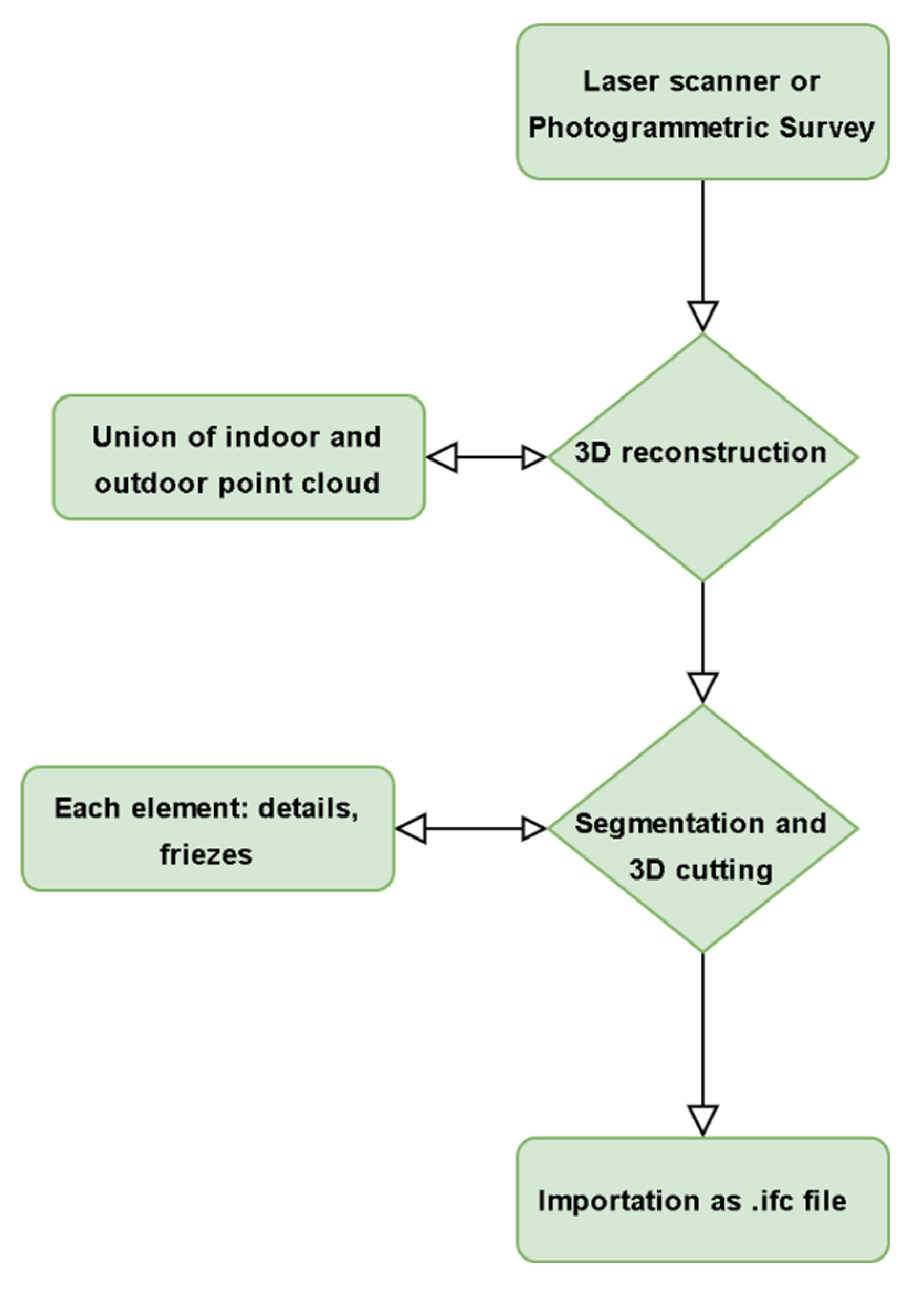
2. Materials and Methods
- Data collection from various technologies;
- Point cloud generation;
- Import and modify point clouds for semi-automatic recognition in a BIM environment;
- Semi-automated BIM element generation;
- Creating models for the remaining components;
- Connecting all components to produce a complete replica of the artifact.
3. Data and Results
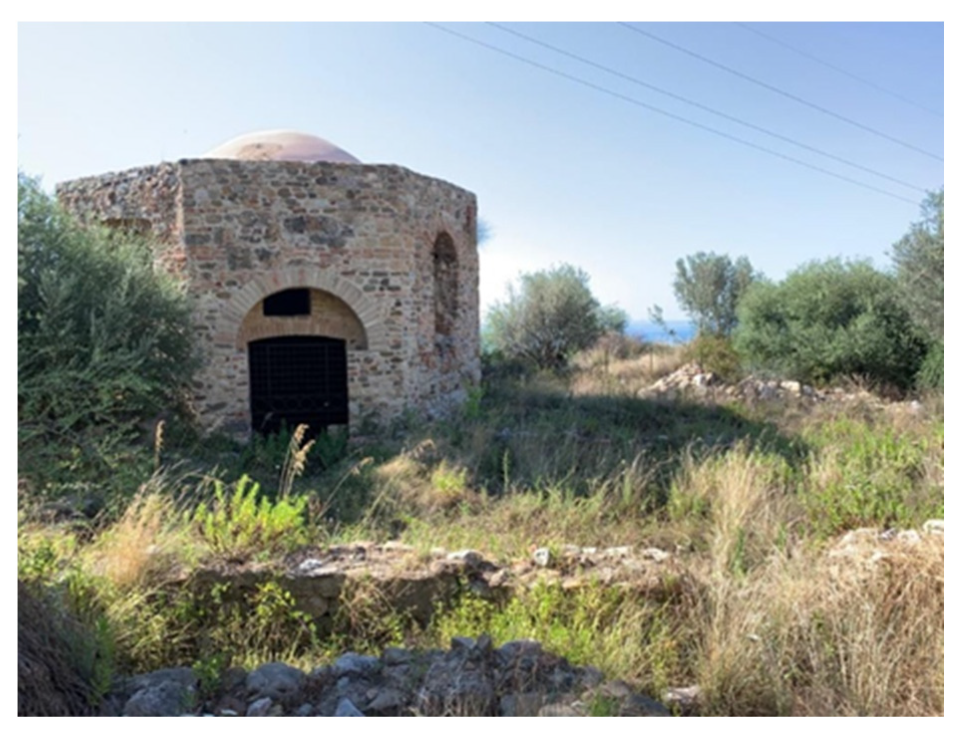
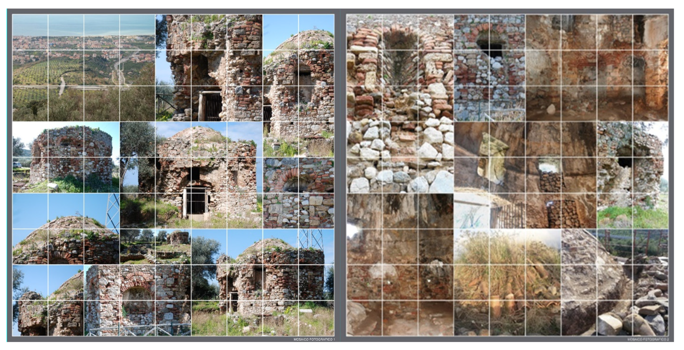
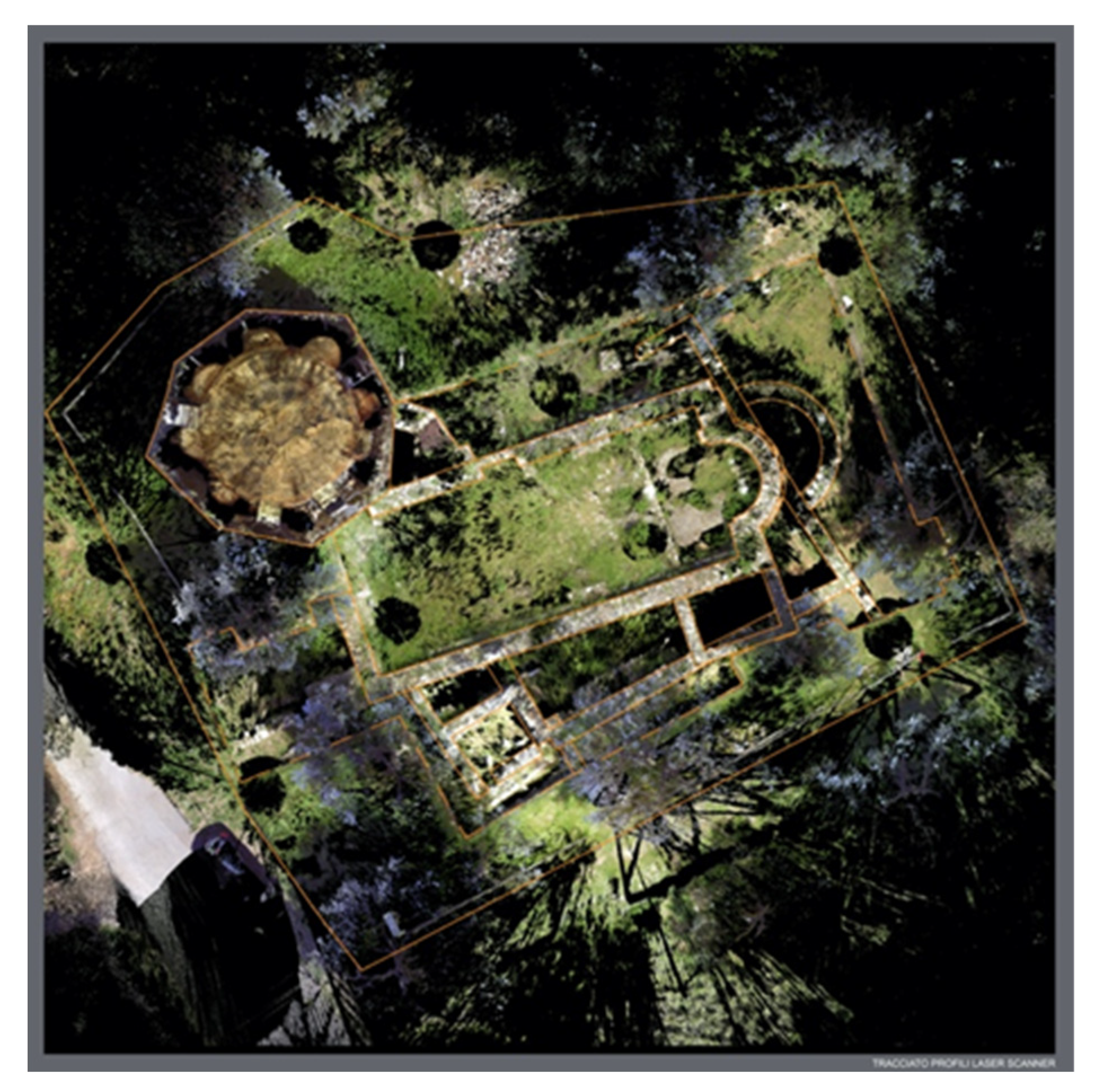
3.1. Case Studies
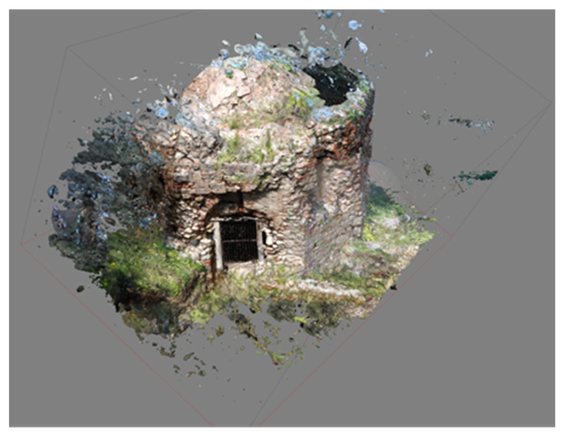
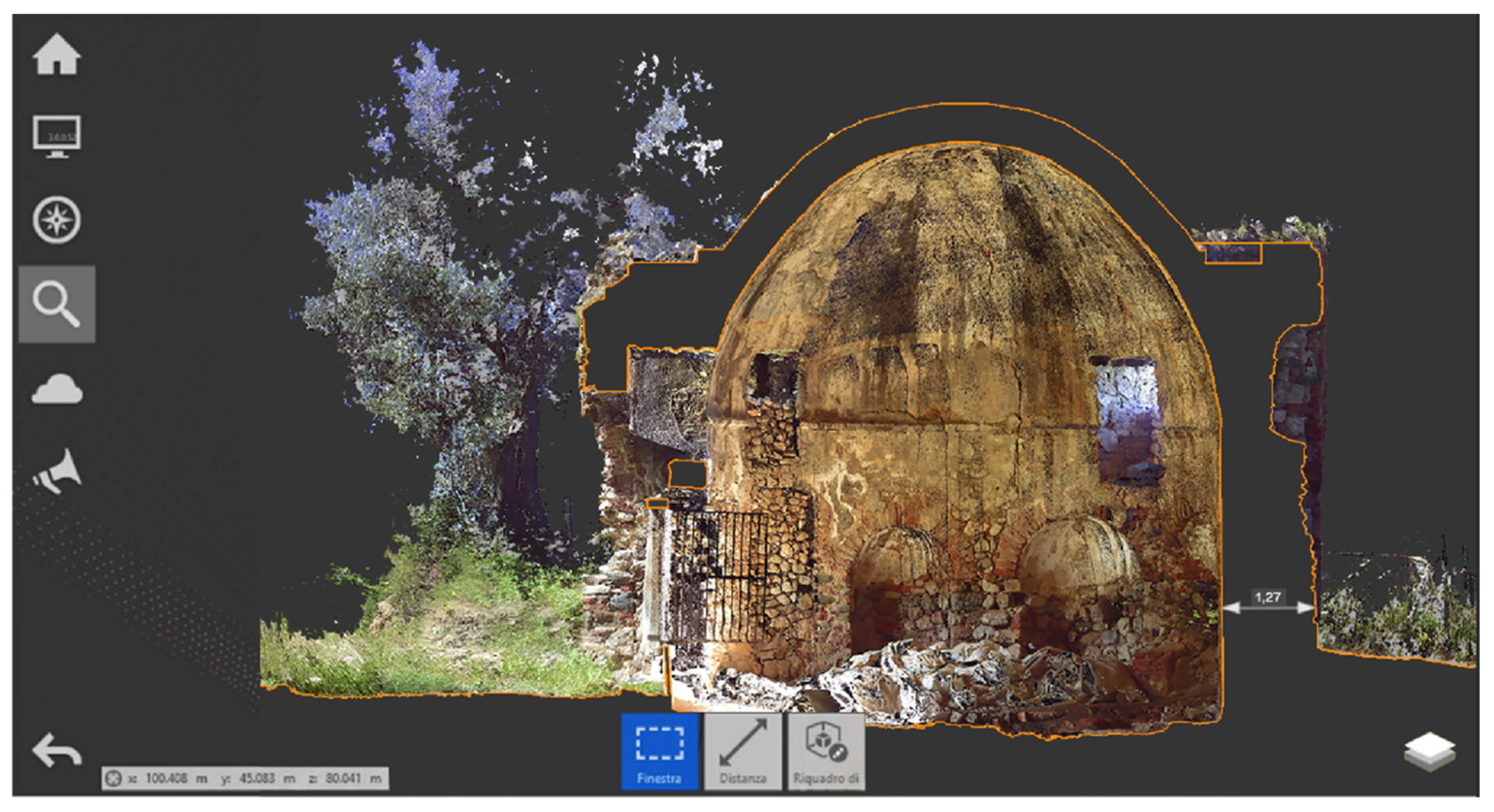
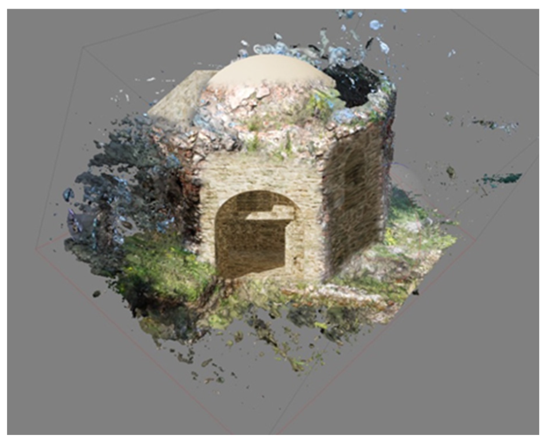
3.2. Model 3D Reconstruction
3.3. HBIM Reconstruction
- The supervised approach is used to classify the full dataset by learning semantic categories from an annotated data set and the trained model.
- There is an unsupervised approach in which data is automatically segmented by user-supplied algorithm parameterization.
- There is an interactive approach in which the user actively participates in segmentation/classification.
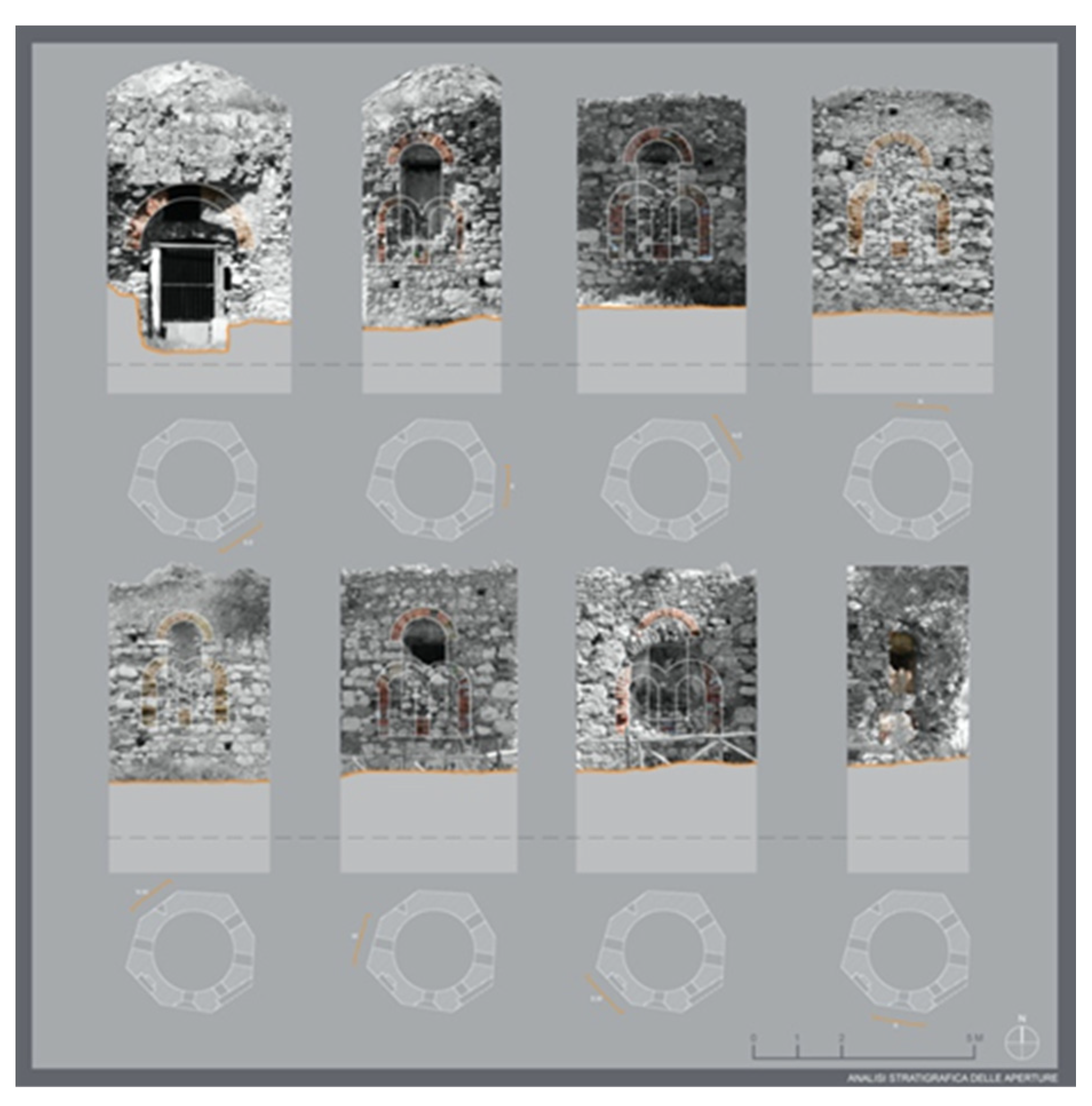
3.4. Morpho-Typological Evolutions
4. Discussion
5. Conclusions
Author Contributions
Funding
Institutional Review Board Statement
Informed Consent Statement
Data Availability Statement
Conflicts of Interest
References
- Banf, F.; Fai, S.; Brumana, R. BIM automation: Advanced modeling generative process for complex structures, ISPRS Annals of the Photogrammetry, Remote Sensing and Spatial Information Sciences. In Proceedings of the 26th International CIPA Symposium, Ottawa, ON, Canada, 28 August–1 September 2017; Volume IV-2/W2. [Google Scholar]
- Valero, E.; Bosché, F.; Forster, A. Automatic segmentation of 3D point clouds of rubble masonry walls, and its application to building surveying, repair and maintenance. Autom. Constr. 2018, 96, 29–39. [Google Scholar] [CrossRef]
- Pocobelli, D.P.; Boehm, J.; Bryan, P.; Still, J.; Grau-Bové, J. BIM for heritage science: A review. Herit. Sci. 2018, 6, 1–15. [Google Scholar] [CrossRef] [Green Version]
- Paris, L.; Wahbeh, W. Survey and representation of the parametric geometries in HBIM. Disegnarecon 2016, 9, 12.1–12.9. [Google Scholar]
- Barazzetti, L.; Banf, F.; Brumana, R.; Previtali, M. Creation of parametric BIM objects from point clouds using Nurbs. Photogramm. Rec. 2015, 30, 339–362. [Google Scholar] [CrossRef]
- Stanga, C.; Hasníková, H.; Previtali, M.; Brumana, R.; Grimoldi, A.; Banf, F. The assessment of the baroque vault construction technique by scan-to-bim process: St. Bernard’s chapel in the plasy monastery. Int. Arch. Photogramm. Remote Sens. Spat. Inf. Sci. 2019, XLII-2/W15, 1127–1134. [Google Scholar] [CrossRef] [Green Version]
- Pierdicca, R.; Paolanti, M.; Matrone, F.; Martini, M.; Morbidoni, C.; Malinverni, E.S.; Frontoni, E.; Lingua, A.M. Point cloud semantic segmentation using a deep learning framework for cultural heritage. Remote Sens. 2020, 12, 1005. [Google Scholar] [CrossRef] [Green Version]
- Oreni, D.; Brumana, R.; Cuca, B. Towards a methodology for 3D content models: The reconstruction of ancient vaults for maintenance and structural behaviour in the logic of BIM management. In Proceedings of the 2012 18th International Conference on Virtual Systems and Multimedia, Milan, Italy, 2–5 September 2012; pp. 475–482. [Google Scholar] [CrossRef]
- Martínez-Carricondo, P.; Carvajal-Ramírez, F.; Yero-Paneque, L.; AgüeraVega, F. Combination of nadiral and oblique UAV photogrammetry and HBIM for the virtual reconstruction of cultural heritage. Case study of Cortijo del Fraile in Níjar, Almería (Spain). Build. Res. Inf. 2020, 48, 140–159. [Google Scholar] [CrossRef]
- Micheletti, N.; Chandler, J.H.; Lane, S.N. Structure from Motion (SFM) Photogrammetry; Geomorphological Technique; British Society for Geomorphology: London, UK, 2015; Chapter 2, Section 2.2; pp. 1–12. ISSN 2047–03711. [Google Scholar]
- López, F.; Lerones, P.; Llamas, J.; Gómez-García-Bermejo, J.; Zalama, E. A review of heritage building information modeling (H-BIM). Multimodal Technol. Interact. 2018, 2, 21. [Google Scholar] [CrossRef] [Green Version]
- Brumana, R.; Oreni, D.; Raimondi, A.; Georgopoulos, A.; Bregianni, A. From survey to HBIM for documentation, dissemination and management of built heritage: The case study of St. Maria in Scaria d’Intelvi. In Proceedings of the 2013 Digital Heritage International Congress (DigitalHeritage), Marseille, France, 28 October–1 November 2013; pp. 497–504. [Google Scholar] [CrossRef]
- Barrile, V.; Fotia, A.; Bilotta, G.; De Carlo, D. Integration of geomatics methodologies and creation of a cultural heritage app using augmented reality. Virtual Archaeol. Rev. 2019, 10, 40–51. [Google Scholar] [CrossRef]
- Barazzetti, L.; Banf, F.; Brumana, R.; Previtali, M.; Roncoroni, F. BIM from laser scans… Not just for buildings: Nurbs-based parametric modeling of a medieval bridge. In Proceedings of the ISPRS Annals of the Photogrammetry, Remote Sensing and Spatial Information Sciences, XXIII ISPRS Congress, Prague, Czech Republic, 12–19 July 2016; Volume III-5. [Google Scholar]
- Özdemir, E.; Remondino, F. Segmentation of 3D photogrammetric point cloud for 3D building modeling. Int. Arch. Photogramm. Remote Sens. Spat. Inf. Sci. 2018, XLII-4/W10, 135–142. [Google Scholar] [CrossRef] [Green Version]
- Yang, X.; Lu, Y.-C.; Murtiyoso, A.; Koehl, M.; Grussenmeyer, P. HBIM modeling from the surface mesh and its extended capability of knowledge representation. ISPRS Int. J. Geo-Inf. 2019, 8, 301. [Google Scholar] [CrossRef] [Green Version]
- Barazzetti, L.; Banf, F.; Brumana, R.; Gusmeroli, G.; Previtali, M.; Schiantarelli, G. Cloud-to-BIM-to-FEM: Structural simulation with accurate historic BIM from laser scans. Simul. Model. Pract. Theory 2015, 57, 71–87. [Google Scholar] [CrossRef]
- Gianinetto, M.; Della, T.S. (Eds.) Digital Transformation of the Design, Construction and Management Processes of the Built Environment; Springer: Cham, Switzerland, 2020. [Google Scholar]
- Dore, C.; Murphy, M. Historic building information modeling (HBIM). In Handbook of Research on Emerging Digital Tools for Architectural Surveying, Modeling, and Representation; Brusaporci, S., Ed.; IGI Global: Hershey, PA, USA, 2015; pp. 239–279. [Google Scholar]
- Murphy, M.; McGovern, E.; Pavia, S. Historic building information modelling (HBIM). Struct. Surv. 2009, 38, 311–327. [Google Scholar] [CrossRef] [Green Version]
- Tucci, G.; Betti, M.; Conti, A.; Corongiu, M.; Fiorini, L.; Matta, C.; Kovačević, C.; Borri, C.; Hollberg, C. BIM for museums: An integrated approach from the building to the collections. Int. Arch. Photogramm. Remote Sens. Spatial Inf. Sci. 2019, XLII-2/W11, 1089–1109. [Google Scholar] [CrossRef] [Green Version]
- Cannistraro, M.; Bernardo, E. Monitoring of the indoor microclimate in hospital environments a case study the Papardo hospital in Messina. Int. J. Heat Technol. 2017, 35, S456–S465. [Google Scholar] [CrossRef]
- Bernardo, E.; Bilotta, G. Monumental Arc 3D Model Reconstruction through BIM Technology. In New Metropolitan Perspectives. NMP 2020. Smart Innovation, Systems and Technologies; Bevilacqua, C., Calabrò, F., Della Spina, L., Eds.; Springer: Cham, Switzerland, 2021; Volume 178. [Google Scholar] [CrossRef]
- Barrile, V.; Fotia, A.; Bernardo, E.; Bilotta, G. Geomatic Techniques: A Smart App for a Smart City. In New Metropolitan Perspectives. NMP 2020. Smart Innovation, Systems and Technologies; Bevilacqua, C., Calabrò, F., Della Spina, L., Eds.; Springer: Cham, Switzerland, 2021; Volume 178. [Google Scholar] [CrossRef]
- Brumana, R.; Della Torre, S.; Oreni, D.; Cantini, L.; Previtali, M.; Barazzetti, L.; Banfi, F. SCAN to HBIM-Post Earthquake Preservation: Informative Model as Sentinel at the Crossroads of Present, Past, and Future. In Digital Heritage. Progress in Cultural Heritage: Documentation, Preservation, and Protection. EuroMed; Ioannides, M., Fink, E., Brumana, R., Patias, P., Doulamis, A., Martins, J., Wallace, M., Eds.; Springer: Cham, Switzerland, 2018; Volume 11196. [Google Scholar] [CrossRef]
- Funari, M.F.; Hajjat, A.E.; Masciotta, M.G.; Oliveira, D.V.; Lourenço, P.B. A Parametric Scan-to-FEM Framework for the Digital Twin Generation of Historic Masonry Structures. Sustainability 2021, 13, 11088. [Google Scholar] [CrossRef]
- Pepe, M.; Costantino, D.; Restuccia Garofalo, A. An Efficient Pipeline to Obtain 3D Model for HBIM and Structural Analysis Purposes from 3D Point Clouds. Appl. Sci. 2020, 10, 1235. [Google Scholar] [CrossRef] [Green Version]


| Elements | Real Measurement (RM) | Photogrammetric Measurement | Laser Scanner Measurement | Points | ΔRP | ΔRL |
|---|---|---|---|---|---|---|
| W. E | 4 | 3.9 | 3.95 | 2 | 0.1 | 0.05 |
| W. N | 3.7 | 3.8 | 3.8 | 4 | 0.1 | 0.1 |
| W. W | 3.9 | 4 | 3.87 | 6 | 0.1 | 0.03 |
| W. S | 3.9 | 4 | 3.87 | 7 | 0.1 | 0.03 |
| H. S | 5.76 | 5.8 | 5.8 | 8 | 0.04 | 0.04 |
| H. E | 4.98 | 5 | 5 | 9 | 0.02 | 0.02 |
| H. N | 5.01 | 5.2 | 5 | 11 | 0.19 | 0.01 |
| H. W | 4.54 | 4.64 | 4.6 | 13 | 0.1 | 0.06 |
| H. internal | 6 | 5.9 | 5.96 | 16 | 0.1 | 0.04 |
| H dome | 7.7 | 7.6 | 7.65 | 17 | 0.1 | 0.05 |
Publisher’s Note: MDPI stays neutral with regard to jurisdictional claims in published maps and institutional affiliations. |
© 2022 by the authors. Licensee MDPI, Basel, Switzerland. This article is an open access article distributed under the terms and conditions of the Creative Commons Attribution (CC BY) license (https://creativecommons.org/licenses/by/4.0/).
Share and Cite
Barrile, V.; Bernardo, E.; Bilotta, G. An Experimental HBIM Processing: Innovative Tool for 3D Model Reconstruction of Morpho-Typological Phases for the Cultural Heritage. Remote Sens. 2022, 14, 1288. https://doi.org/10.3390/rs14051288
Barrile V, Bernardo E, Bilotta G. An Experimental HBIM Processing: Innovative Tool for 3D Model Reconstruction of Morpho-Typological Phases for the Cultural Heritage. Remote Sensing. 2022; 14(5):1288. https://doi.org/10.3390/rs14051288
Chicago/Turabian StyleBarrile, Vincenzo, Ernesto Bernardo, and Giuliana Bilotta. 2022. "An Experimental HBIM Processing: Innovative Tool for 3D Model Reconstruction of Morpho-Typological Phases for the Cultural Heritage" Remote Sensing 14, no. 5: 1288. https://doi.org/10.3390/rs14051288
APA StyleBarrile, V., Bernardo, E., & Bilotta, G. (2022). An Experimental HBIM Processing: Innovative Tool for 3D Model Reconstruction of Morpho-Typological Phases for the Cultural Heritage. Remote Sensing, 14(5), 1288. https://doi.org/10.3390/rs14051288