1. Introduction
The tropical diurnal cycle of precipitation is highly prominent in atmospheric thermodynamics since it is closely related to variations in surface fluxes, evaporation, latent heat exchange processes (e.g., latent heat of condensation), and thermodynamic and dynamic forcings of land surface types and terrain, particularly through the modulation of cloud radiative effects and the hydrological cycle. Understanding atmospheric processes are crucial against the background of global climatic change and environmental threats, which facilitates gaining knowledge of the impacts of human activities on the climate. For example, as two of the prominent impacts of human activities, pollutant emissions and the urban heat island effect can impact precipitation variation [
1,
2,
3,
4,
5,
6]. However, these major phenomena attributed to human activities may affect the structure and life cycle of convective systems as a result of the diurnal cycle of rainfall [
7].
There are numerous studies on the diurnal cycle of precipitation in various regions worldwide, with the diurnal cycle of precipitation variation notable [
8]. By examining the seasonal climate variation and rainfall diurnal cycle in island countries (e.g., Japan and Malaysia), Oki and Musiake [
9] revealed that the convective peak at night was mainly triggered by thermodynamic forcing in the inland region of Malaysia, while the rainfall peak during the monsoon season in the morning was primarily associated with low-level convergence between local land–sea breezes and typical monsoon winds. Bechtold et al. [
10] examined the diurnal cycle using global model results. They revealed that their model could produce a diurnal precipitation cycle, whereas it could not reproduce the gradual growth in deep convective clouds. Other studies have reported that afternoon or midnight peak and morning minimum rainfall levels generally occur in land and oceanic regions [
11,
12,
13]. Dai et al. [
14] applied satellite data and further confirmed afternoon–evening maximum values, noting that the diurnal cycle of the rainfall amount could be mainly attributed to the frequency instead of the intensity in most low-latitude and mid-latitude areas. Kikuchi and Wang [
15] found early morning and afternoon peaks in coastal and continental regions, respectively. Sea- and land-side coastal regimes were characterized by notable peaks from the late evening to noon during the next day and from noon to evening. With the use of half-hourly precipitation estimates obtained from the Integrated Multi-satellite Retrievals for Global Precipitation Measurement (IMERG) product, Tan et al. [
16] also found peak rainfall in the afternoon on the land side approaching the coast. In contrast, rainfall peaked in inland areas in the late afternoon or the evening. Maximum rainfall occurred around midnight and in the morning in the ocean close to the shore and offshore, respectively. These studies indicate that precipitation can be characterized by the diurnal cycle in continental and oceanic regions [
17]. Kwajalein Island is located at the center of the Pacific Ocean, but no studies have specifically considered the diurnal cycle over this island. Is the diurnal cycle over Kwajalein Island similar to the ocean mode, or does it reflect a typical island mode?
Two-dimensional (2D) cloud-resolving models (CRMs) have been applied for a long time due to limitations in computational power. As computer power has dramatically increased in recent decades, three-dimensional (3D) CRMs have been widely used to examine deep convection [
18,
19,
20]. Moncrieff and Miller [
21] revealed that a 3D model could simulate crossover flow patterns due to the propagation of tropical squall lines. However, Rotunno et al. [
22] demonstrated that a 2D model could generally reproduce the thermodynamic processes leading to an intense squall line system with a long life span in an environment with notable low-level shear. Tao and Soong [
23], Tao et al. [
24], Grabowski et al. [
20], and Wang et al. [
25] determined that the thermodynamic feedback effect, moisture, sensible heat, mass vertical transport, and surface rainfall were similar between 2D and 3D CRM simulation results. Sui et al. [
26] observed that the cloud microphysical and large-scale rainfall efficiencies calculated via the 2D CRM simulation of a tropical convective system with imposed forcing and the 3D CRM simulation of a typhoon excluding forcing were statistically equivalent.
Xu et al. [
27] analyzed CRM model runs during an atmospheric radiation measurement (ARM) campaign and revealed apparent disparities in dynamics between 2D and 3D model results. Gao et al. [
28] and Gao [
29] demonstrated that the vertical and horizontal components of vorticity were highly correlated with hydrometeors in both 3D and 2D simulations. This occurred because their 2D model simulations excluded the predominant terms associated with the horizontal components of the 3D vorticity. Stephens et al. [
30] found that the differences in the spatial scale of precipitable water varied between 2D and 3D model results, but the feedback associated with radiative processes was similar.
Although 3D CRMs can simulate realistic cloud structures, microphysical properties, and dynamics, 2D CRMs are still widely applied due to their economic computations. One application entails the installation of a 2D CRM in each grid column of general circulation models, such as the National Center for Atmospheric Research (NCAR) Community Climate System Model (CCSM) by Khairoutdinov and Randall [
31], which is referred to as the cloud-resolving convection parameterization scheme initially proposed by Grabowski and Smolarkiewicz [
32] and Grabowski [
33]. The results revealed reasonable simulations of the spatial distributions of precipitation, cloud cover, precipitable water, and radiation budget. Thus, the impact of dimensionality on CRM simulations requires a comprehensive and deep understanding.
The diurnal cycle is fundamental in reflecting variations in weather systems. This phenomenon stems from the diurnal cycle of radiation, but the impact of dimensionality on diurnal cycle modeling has seldom been investigated. Therefore, the objective of this study was to use 2D and 3D Tropical Rainfall Measuring Mission Kwajalein Experiment (KWAJEX) simulation data to examine the impact of dimensionality on the CRM simulations of the diurnal cycle in terms of the total hydrometeor mixing ratio, perturbation kinetic energy (PKE) budget, specific humidity, temperature, and fractional cloud coverage. The model and experiments are briefly described in the next section.
Section 3 presents the results and
Section 4 provides a summary.
2. Model, Experiments, and Large-Scale Forcing
The 2D and 3D model results applied in this research were obtained from the Mesoscale Modeling and Dynamic Group at the NASA Goddard Space Flight Center [
34] and were generated by 2D and 3D Goddard Cumulus Ensemble (GCE) models, respectively. The model results were compared to observations from other studies [
35]. The GCE CRM was developed by Soong and Tao [
36] and Soong and Ogura [
37] and was used by Tao and Soong [
23] and Tao and Simpson [
38] to study the life span of convective clouds for less than a day. Sui et al. [
39] employed the GCE model to study the equilibrium state of tropical climate conditions. This model incorporates a dynamic core by Lang et al. [
40] and Zeng et al. [
41] and a subgrid scheme to manage turbulence by Klemp and Wilhelmson [
18]. The model contains a predictive equation to determine the specific humidity and five predictive equations for cloud ice, cloud water, raindrops, snow, and graupel with the water vapor and cloud hydrometeor sources/sinks associated with cloud microphysical processes, as parameterized by Lin et al. [
42], Rutledge and Hobbs [
43,
44], and Tao et al. [
45]. The model equation for the potential temperature includes external sources/sinks associated with solar shortwave and infrared longwave radiative parameterizations developed by Chou et al. [
46], Chou and Suarez [
47], and Chou et al. [
48] and latent heat associated with cloud microphysical processes. The horizontal domain of the 2D model comprises 512 mesh points, while the 3D model domain includes 256 meridional and 256 zonal grid points. The horizontal resolution is 1 km and the vertical resolution reaches approximately 80 m in the lower layer and approximately 1 km at high levels. The 2D and 3D models applied periodic lateral boundaries and included 41 vertical levels with a time step of 12 s.
The model domains are too small to be reasonably simulated by GCE models. Therefore, the model employed large-scale forcing. Large-scale forcing was imposed on both models, including latitudinal wind, vertical velocity, temperature, and water vapor advection, and a horizontally uniform meridional wind was imposed on the 3D model. Six-hourly KWAJEX measurements during the experiments were used to calculate large-scale forcing fields [
35]; please refer to
Figure 1 in Xu and Li (2017) [
49]. The domain of Kwajalein is presented in
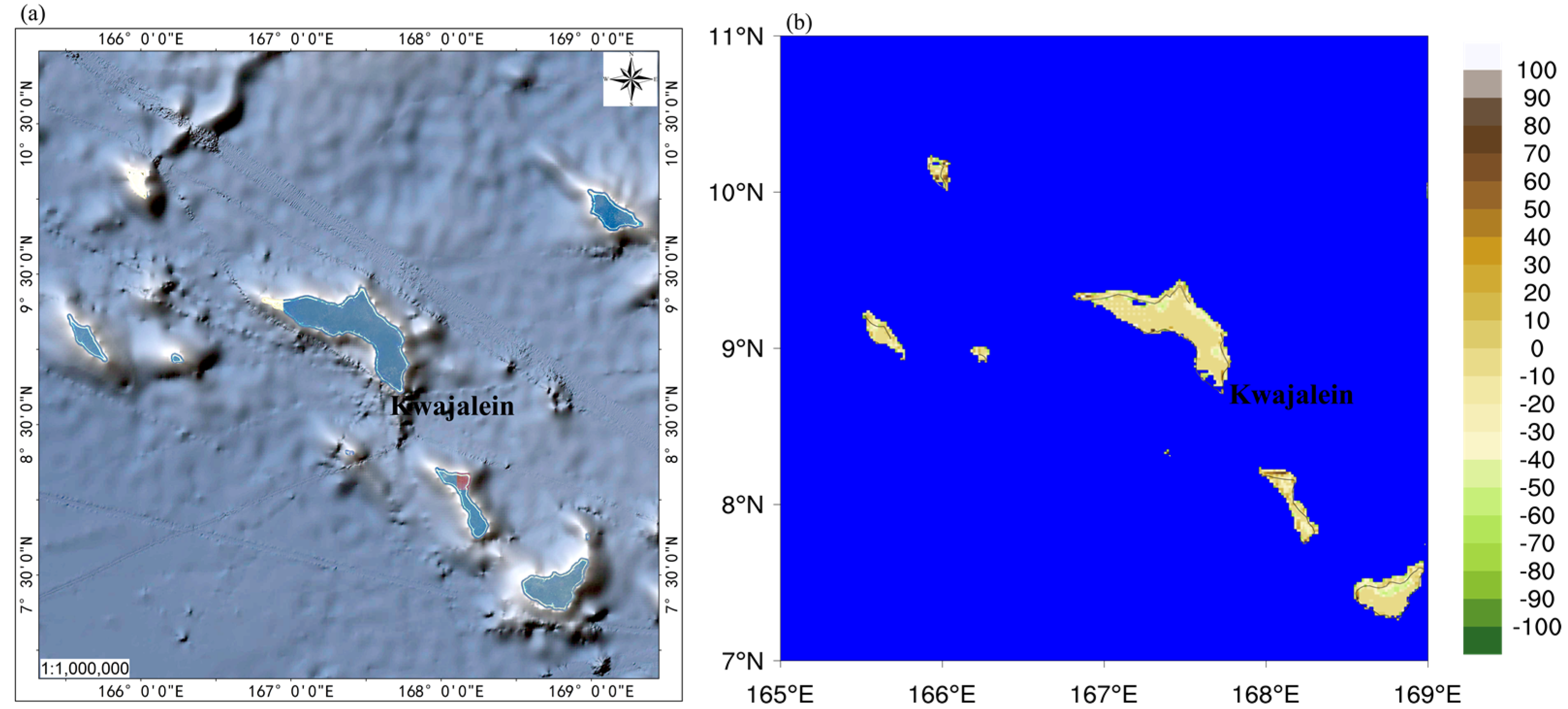
Figure 1. Kwajalein Island is located at 8.72°N and 167.73°E and is the largest island in the Kwajalein Atoll as Schumacher et al. [
50] and Cetrone and Houze [
51]. Kwajalein Island is located on the north side of the Intertropical Convergence Zone (ITCZ) in the western Pacific. The Kwajalein field experiment was conducted from 24 July to 15 September 1999 as showed in Schumacher et al. [
52], Schumacher et al. [
53], Sobel et al. [
54], and Li et al. [
55]. The total rainfall during this period decreased from south to north. Easterly winds and alternating weak northerly and southerly winds prevailed during KWAJEX. Ascending motion centers emerged on the last five days of July, the first ten days of August, and the first three days of September. Both the 2D and 3D simulations applied a wind component near the surface to calculate surface fluxes. The distinction was that spatial mean longitudinal winds were imposed during the 2D simulations, while the 3D simulations employed a time series of longitudinal winds. Linearly interpolated six-hourly large-scale forcing data were imposed in the model runs at each time step during model integration. The simulation domain was centered at 9°N and 167°E in both model runs. The simulations in this study were conducted with 2D and 3D CRM models covering the period from 24 July to 14 September 1999, with Shie et al. [
35] comparing those simulations with the observations and showing that the results suitably agreed with the observations. Hourly simulation data from 1100 local solar time (LST) on 24 July to 1100 LST on 13 September 1999 were considered in the following analyses. The following analysis in Figures 2–12 is domain averaged over the domain of 7–11°N and 165–169°E, as shown in
Figure 1.
The orography datasets used in this study in
Figure 1b were based on Earth topography five-minute grid (ETOPO5) data (Data Announcement 88-MGG-02: Digital relief of the Surface of the Earth; NOAA, National Geophysical Data Center, Boulder, Colorado, 1988). ETOPO5 was generated from a digital database of sea-floor and land elevations on a 5 min latitude/longitude grid. The detailed resolution of the gridded data generally varied from true 5 min data for the ocean floors, the USA, Japan, Europe, and Australia to 1 degree in the data-deficient parts of Asia, South America, northern Canada, and Africa. The ETOPO5 terrain datasets are also available by online searching at the following URL:
https://www.ngdc.noaa.gov/mgg/global/global.html (accessed on 1 July 2022).
Figure 1.
Map of Kwajalein area, which shows the geography of Kwajalein and the neighboring atolls. The left panel (
a) shows multi−spectral optical remote sensing images with four bands with a spatial resolution of 10 m on 3 and 14 December, provided by Sentinel−2 satellites. Data can be accessed at
https://scihub.copernicus.eu/dhus/#/home on 1 July 2022. The right panel (
b) shows the land/sea distribution around the Kwajalein and neighboring atolls.
The ice (liquid) water path (IWP, LWP) is a fundamental parameter for estimating ice and liquid water contents. To obtain the vertical profile for the IWP and LWP, the IWP (LWP) of each layer is obtained by conducting an integral of every two adjacent layers of the ice (liquid) water content, which can provide important information about clouds and precipitation. Following Equations (A1) and (A2) in
Appendix A, the vertical structures of the IWP and LWP depend on the depth of the layers. In this study, the IWP and LWP were calculated using 2D and 3D CRM-simulated data, and the convective and stratiform partition methods used in this study generally followed Sui et al. [
56] according to the IWP-to-LWP ratio, defined as the cloud ratio. In detail, grids were classified as convective grids when the ratio between the IWP and LWP was lower than 0.2. At a ratio between the IWP and LWP higher than 0.2, grids were classified as stratiform grids, while at an IWP-to-LWP ratio between 1.0 and 0.2, grids were classified as mixed rainfall grids, with the mixed rainfall grids included in convective grids in this study. The convective and stratiform grids were selected for each grid for each hourly output time. Considering that the mixed category could be regarded as a different type of rainfall and not robust stratiform [
56], in this study, we included the mixed category in the convective precipitation category. The cloud coverage was calculated as the number of cloudy grids divided by the total number of model grids. A given grid was denoted as a cloudy grid when the sum of the cloud water, raindrops, ice, snow, and graupel content exceeded 5 × 10
−3 g·m
−3.
In addition, Tropical Rainfall Measurement Mission (TRMM) Microwave Imager (TMI) 2A12 products were used to verify the simulation results. The cloud water, raindrops, ice, snow, and graupel mixing ratios retrieved from the TRMM 2A12 data were compared to the 2D and 3D CRM simulation results. From 1100 UTC on 23 July 1999 to 1100 UTC on 13 September 1999, the mixing ratios of cloud water, raindrops, ice, snow, and graupel from the TRMM 2A12 data were available in the domain between 7–11°N and 165–169°E, with the center located at 9°N, 167°E; the available domain is shown in
Figure 1. The comparison of the hydrometeor mixing ratio profiles between simulations and TRMM products are provided below.
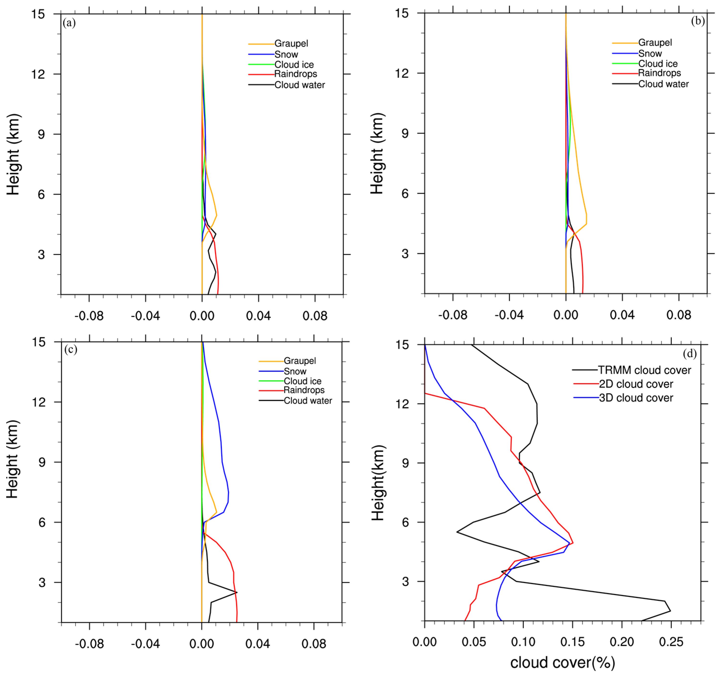
Figure 2 shows that the simulated hydrometeors were generally smaller than those in the TRMM 2A12 data. The CRM simulation results and TRMM data revealed similarities that raindrops were generally distributed below 5 km. The mean cloud water in the simulations and TRMM 2A12 data show similar magnitudes of approximately 0.02 g·m
−3 below 5 km; while the cloud water shows an obvious bump at 2.5 km in the TRMM 2A12 data, the bump was approximately half a size (0.01 g·m
−3) smaller in the 2D CRM simulation, with no bumps found in the 3D CRM simulation. The simulated cloud ice and snow in the 2D and 3D CRM simulation results exhibited similar vertical structures to those in the TRMM 2A12 data, with cloud ice and snow distributed above 6 km. The simulated raindrops and snow were smaller than those in the TRMM 2A12 data. The simulated cloud water exhibited similar magnitudes of 0.01 g·m
−3 between the 2D and 3D CRM simulation results. The simulated ice in the 2D and 3D CRM simulation results and the TRMM 2A12 data were approximately one order of magnitude smaller than the other hydrometeors. However, disparities occurred between the simulated hydrometeors and TRMM data. The simulated snow in the 2D and 3D CRM simulation results was much smaller than the retrieved snow in the TRMM 2A12 data; another difference was that the vertical structure of the cloud water in the TRMM 2A12 data exhibited a peak at a height of 2.5 km.
Figure 2d shows the results by comparing the observed and simulated cloud covers, with cloud cover calculated using the threshold value of 5 × 10
−3 g·m
−3. It shows that the 2D and 3D model simulations underestimate the cloud cover throughout the troposphere, while they overestimate the cloud cover at around 5 km. The underestimation of the ice content above the melting level in both the 2D and 3D CRM simulations may be associated with the underestimation of the cloud cover above the melting level.
Figure 2.
Domain mean profiles of the cloud water content, rain content, cloud ice content, snow content, and graupel content based on (a) the 2D and (b) 3D CRM simulations, (c) TRMM data, and (d) cloud cover for the 2D and 3D CRM simulations, as well as for the TRMM data. The domain ranges from 7−11°N and 165−169°E. Unit: g·m−3.
3. Results
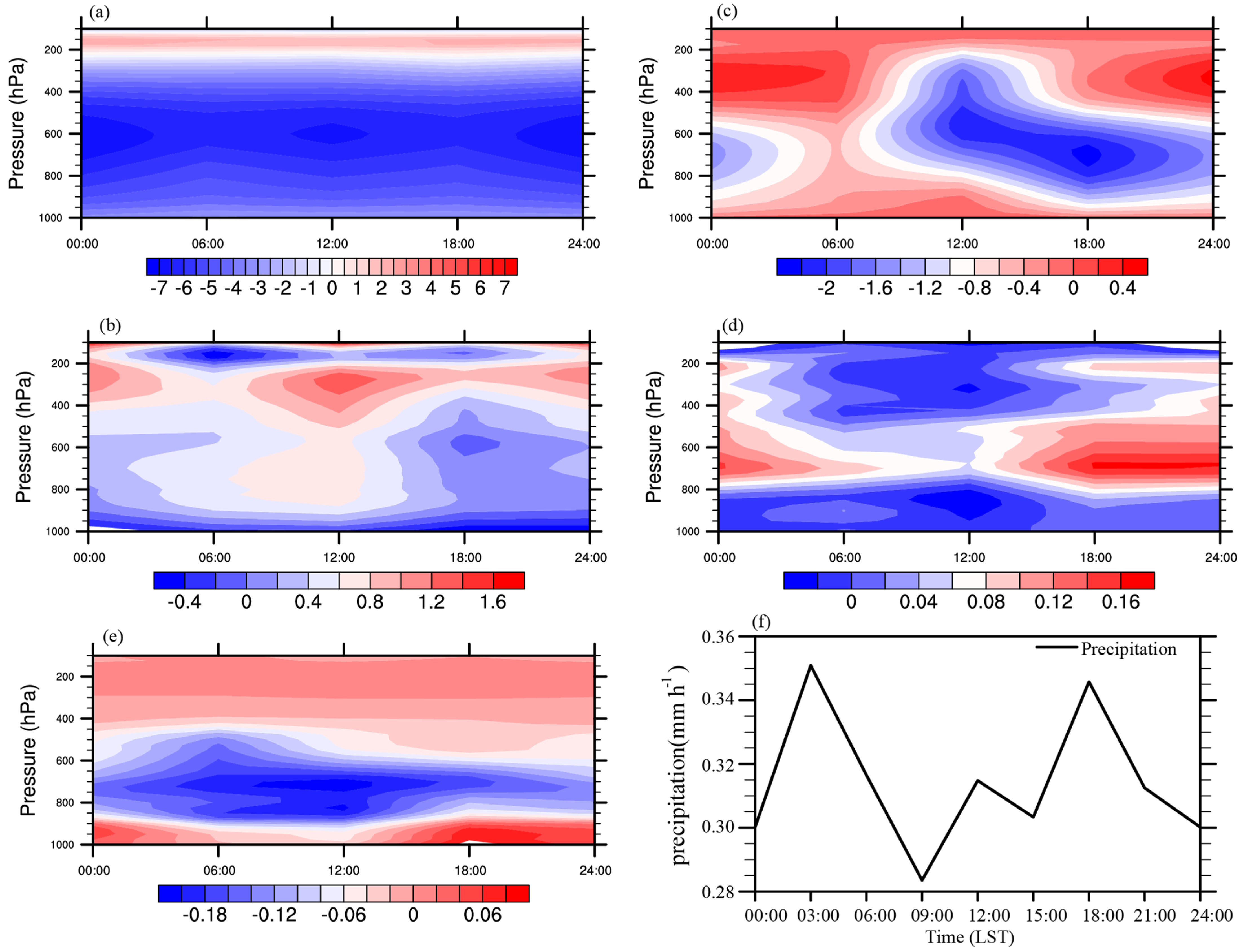
We conducted diurnal composites of vertical profiles of large-scale zonal, meridional, and vertical components of the velocity, horizontal temperature advection, and horizontal advection of the water vapor mixing ratio. Negative values of zonal winds denote easterly winds, positive values of meridional winds denote southerly winds, and negative values of vertical winds denote upward motions. The background used in the simulations showed that positive values of horizontal temperature advection and positive values of horizontal advection of the water vapor mixing ratio were related to warm and moist air with easterly winds. The diurnal composites of winds imposed in the simulations indicated prevailing easterly winds below 250 hPa, with maxima observed from 500 to 700 hPa between 2200 and 0400 LST and between 1100 and 1300 LST (
Figure 3a). Southerly winds generally occurred throughout the troposphere, with a maximum occurring at approximately 300 hPa at 1200 LST; in addition, the lower levels exhibited weak northerly winds (
Figure 3b). Upward motions generally prevailed throughout the troposphere (
Figure 3c). Strong upward motions started at 1200 LST in the middle-to-lower troposphere (400–800 hPa), then moved towards the lower troposphere (600–850 hPa) at midnight (2200 LST), and were maintained until 0300 LST. Warm horizontal advection started from 1200 LST in the middle-to-lower troposphere (400–800 hPa), whereas moist horizontal advection started at a similar time in the lower troposphere (1000–800 hPa). Both were continuous at 0600 LST in the early morning (
Figure 3d,e).
Figure 3.
Diurnal composite of the large-scale forcing variables in the KWAJEX data: (a) large−scale zonal (ms−1), (b) meridional (m s−1), and (c) vertical (hPa h−1) components of the velocity; (d) horizontal temperature advection (10−1 K h−1), and (e) horizontal advection of the water vapor mixing ratio (10−1 g kg−1 h−1); and (f) precipitation using the three−hourly rainfall (mm) from TRMM 3B42 data.
The TRMM 3B42 datasets are rain estimates with a horizontal resolution of 0.25 × 0.25 degrees and were obtained by integrating the passive microwave (TMI) 2A12 rain estimates and IR rain rates. For a detailed algorithm for the dataset, refer to Huffman et al. [
57,
58] and Huffman [
59]. TRMM 3B42 datasets were used to plot the diurnal cycle of rainfall during KWAJEX in
Figure 3f. Rainfall peaks occurred in the afternoon and at night (
Figure 3f).
The vertically integrated mixing ratios of snow, cloud ice, and graupel (IWP) and vertically integrated mixing ratios of cloud water and raindrops (LWP) were used to determine the rainfall intensity following Sui et al. [
56]. According to Heymsfield et al. [
60] and the National Center for Atmospheric Research Staff [
61], the IWP and LWP formulations are provided in
Appendix A.
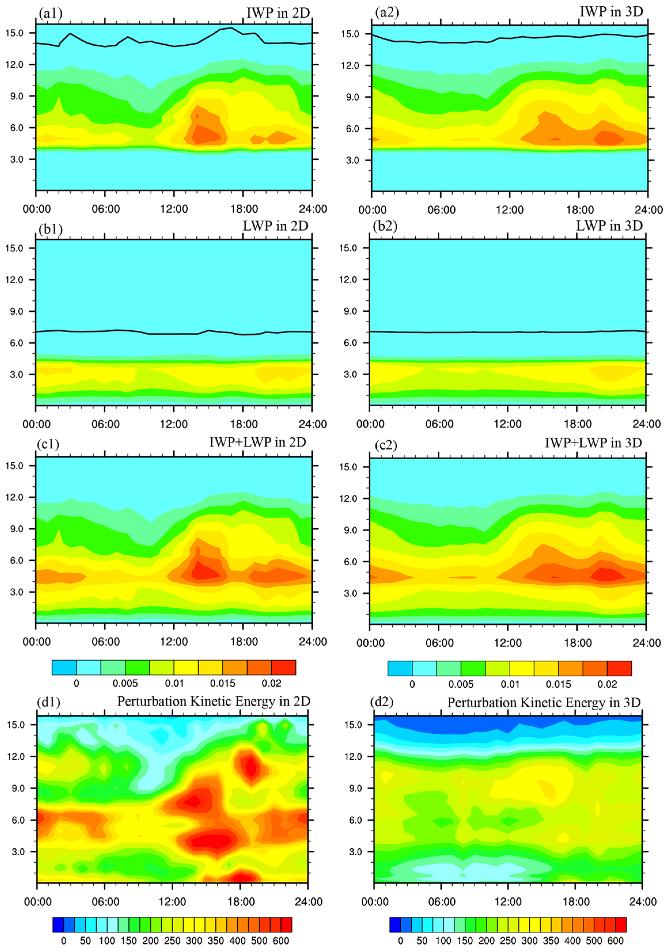
Figure 4 shows the diurnal cycles of IWP+LWP and PKE based on the 2D and 3D simulation results. The similarities in the diurnal cycle of the IWP and LWP between the 2D and 3D model runs indicated that (1) much higher values of IWP, LWP, and IWP+LWP were attained in the afternoon (1200–1800 LST) and at midnight (2000–0300 LST) than in the morning, and maxima occurred during the period from 1200 to 1800 LST at elevations ranging from 3 to 6 km; (2) the maximum IWP value occurred in the afternoon and the maximum LWP value occurred during the nighttime, leading to two IWP+LWP peaks in the afternoon (1300–1600 LST) and at night (1900–2200 LST) in the 2D model runs. In comparison, the maximum IWP and LWP values occurred during the nighttime, leading to an IWP+LWP peak at night (1900–2200 LST) in the 3D model runs; the simulated nighttime IWP+LWP peak may be associated with enhanced condensation due to constraint saturation specific humidity corresponding to radiative cooling as pointed out by Sui et al. [
62] and Gao and Li [
63]; (3) minimum IWP, LWP, and IWP+LWP values were obtained from the early morning until noon (0400–1200 LST). The differences revealed that the maximum IWP, LWP, and IWP+LWP values in the 2D simulation results occurred in the afternoon (1300–1600 LST), whereas the maximum values in the 3D simulation results occurred in the evening (1900–2200 LST). The midnight peaks are the same in the 2D and 3D simulations, but the late-afternoon peak in the 3D simulation seems delayed from the one in the 2D simulation. This may because clouds in the 2D CRM develop more quickly from shallow convection to deep convection than those in the 3D CRM, as indicated by other studies [
64,
65,
66].
Figure 4.
Diurnal composite of (a1) IWP, (b1) LWP, (c1) IWP+LWP, and (d1) perturbation kinetic energy in the 2D model runs and (a2) IWP, (b2) LWP, (c2) IWP+LWP, and (d2) perturbation kinetic energy in the 3D model runs. The units are mm for IWP+LWP and J m−2 for the perturbation kinetic energy. Black lines in (b1,b2) indicate liquid cloud tops, while those in (a1,a2) indicate ice cloud tops.
It was supposed that PKE could represent cloud development related to secondary circulations, and secondary circulations can be measured based on PKE [
49,
67]. The IWP+LWP value was closely correlated to PKE in the 3D and 2D simulation results, as shown by Xu and Li [
49].
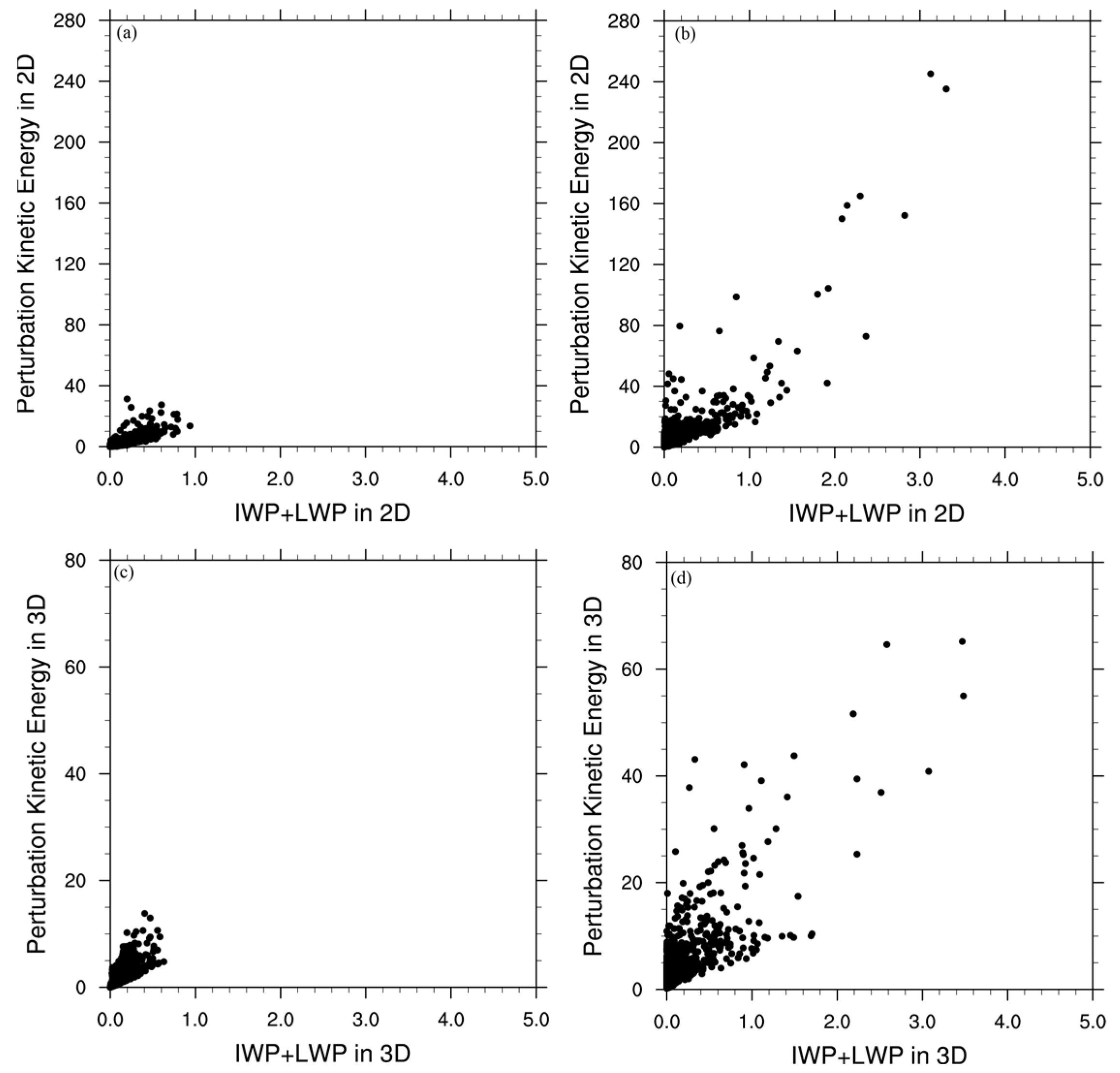
Figure 5 shows the scatterplots of the vertical sum of IWP+LWP versus PKE for both convective and stratiform regions in the 2D and 3D runs using hourly data (
Figure 5a–d). This shows that IWP+LWP and PKE in convective (stratiform) regions in the 2D CRM run are highly correlated, with a correlation coefficient of 0.80 (0.86); the correlation coefficient of IWP+LWP and PKE in convective (stratiform) regions in the 3D CRM run is 0.78 (0.78). The above correlation coefficients exceed the critical value (0.021) for the Student’s
t-test with 1222 degrees of freedom, indicating that the correlations of IWP+LWP and PKE in the 2D and 3D CRMs are significant at the 0.01 confidence levels. Thus, the diurnal cycle of clouds indicated by IWP+LWP can be further measured by PKE both in 2D and 3D CRM runs. Thus, the diurnal cycle of PKE was analyzed.
Figure 4(d1,d2) shows the diurnal variation in PKE. However, PKE in the 2D model is significantly larger than that in the 3D model. PKE in the 2D and 3D model runs revealed diurnal cycles with maxima in the afternoon and minima in the morning. PKE was characterized by large amplitudes in the middle troposphere and lower troposphere, with a peak continuing from noon to midnight (1200–0000 LST). The high-PKE area in the 2D CRM from 1200 LST to 2200 LST also extended from 2 km to 12 km. To determine the dominant physical processes of the diurnal cycle of PKE, the equation budget of PKE is further analyzed in the following section.
Figure 5.
Scatterplots of vertical sum of IWP+LWP versus PKE (unit: 103 J m−2) for (a) convective component from 2D CRM simulation, (b) stratiform component from 2D CRM simulation, (c) convective component from 3D CRM simulation, and (d) stratiform component from 3D CRM simulation.
Figure 5.
Scatterplots of vertical sum of IWP+LWP versus PKE (unit: 103 J m−2) for (a) convective component from 2D CRM simulation, (b) stratiform component from 2D CRM simulation, (c) convective component from 3D CRM simulation, and (d) stratiform component from 3D CRM simulation.
PKE budget equations were derived following Li et al. [
67], Xu and Li [
49], and Li and Li [
68]. Barotropic conversion and buoyancy sources generally exert nonnegligible effects on the development of convective systems. The diurnal cycle of cloud hydrometeors is closely related to PKE. Thus, we examined the tendency of the PKE budget to investigate the diurnal cycle characteristics of cloud hydrometeors.
Following Li et al. [
67], Xu and Li [
49], and Li and Li [
68], the PKE budget equation is given in
Appendix B. PKE was determined through barotropic and baroclinic conversions between the average kinetic energy and PKE in the PKE budget equation. Thus, the diurnal cycle of barotropic and baroclinic conversions was analyzed, as shown in
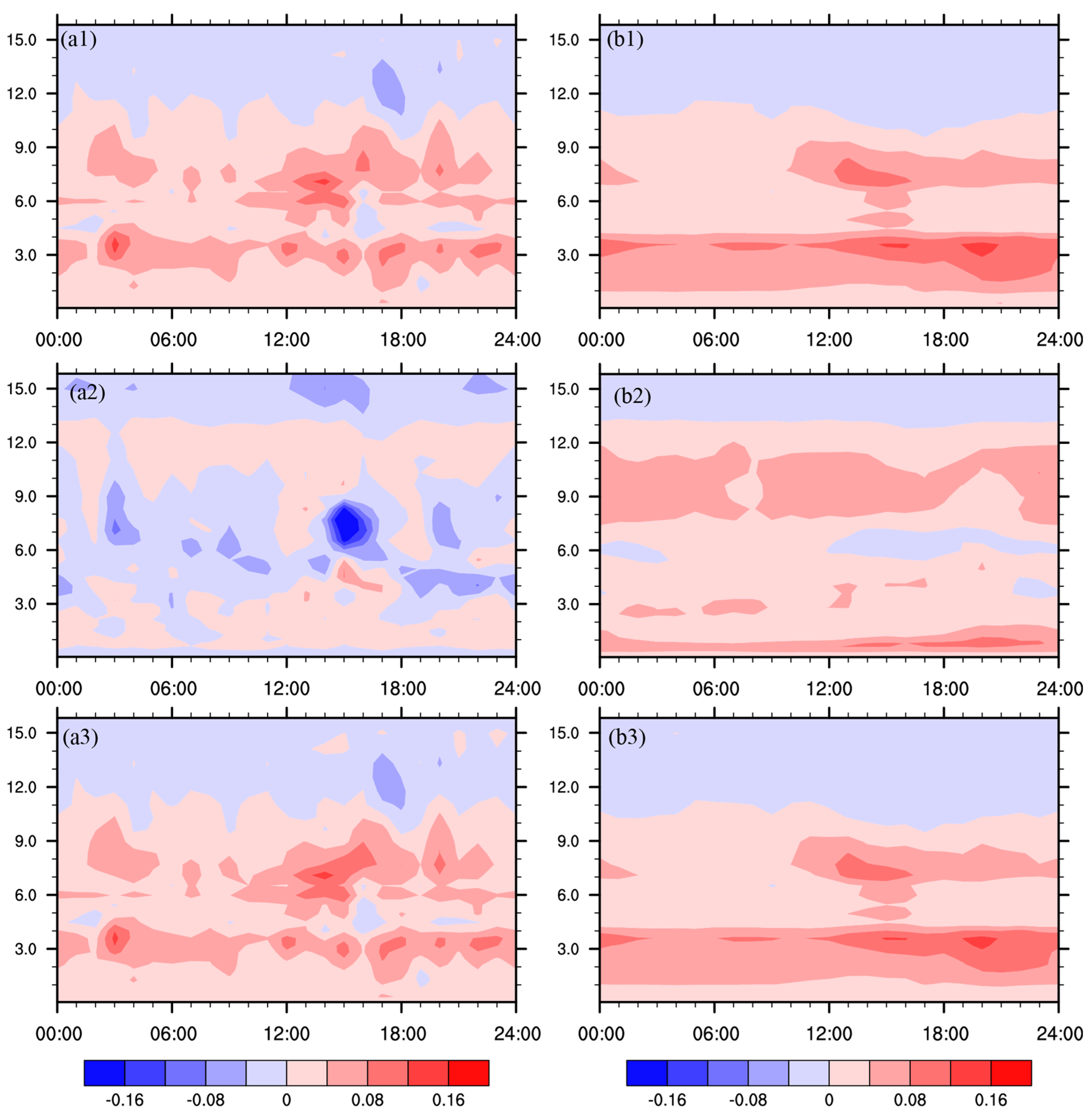
Figure 6. The maximum PKE value was generally associated with the maximum baroclinic conversion in the lower and upper troposphere. The minimum PKE value in the middle troposphere (4–6 km) was mainly related to the negative barotropic conversion in the 2D and 3D model simulations, and the negative barotropic conversion in the 2D simulations was much more significant than that in the 3D simulations (
Figure 6(a1,a2,b1,b2)). PKE in the 2D and 3D simulations revealed diurnal cycles with maxima in the afternoon and minima in the morning. Baroclinic conversion peaks were observed in the upper troposphere from the afternoon to the nighttime (1200–0000 LST), with maximum values emerging from 2 to 4 km and from 6 to 9 km (
Figure 6(a3,b3)). A negative barotropic conversion peak occurred in the middle troposphere in the afternoon (1500–1600 LST) in the 2D simulations.
Figure 6.
Diurnal composite of (a1) the tendency of the perturbation kinetic energy (), (a2) , and (a3) in the 2D model runs, and (b1) the tendency of the perturbation kinetic energy (), (b2), and (b3) in the 3D model runs. The units are 10−1 J m−2 s−1 for barotropic conversion and J m−2 s−1 for the other terms.
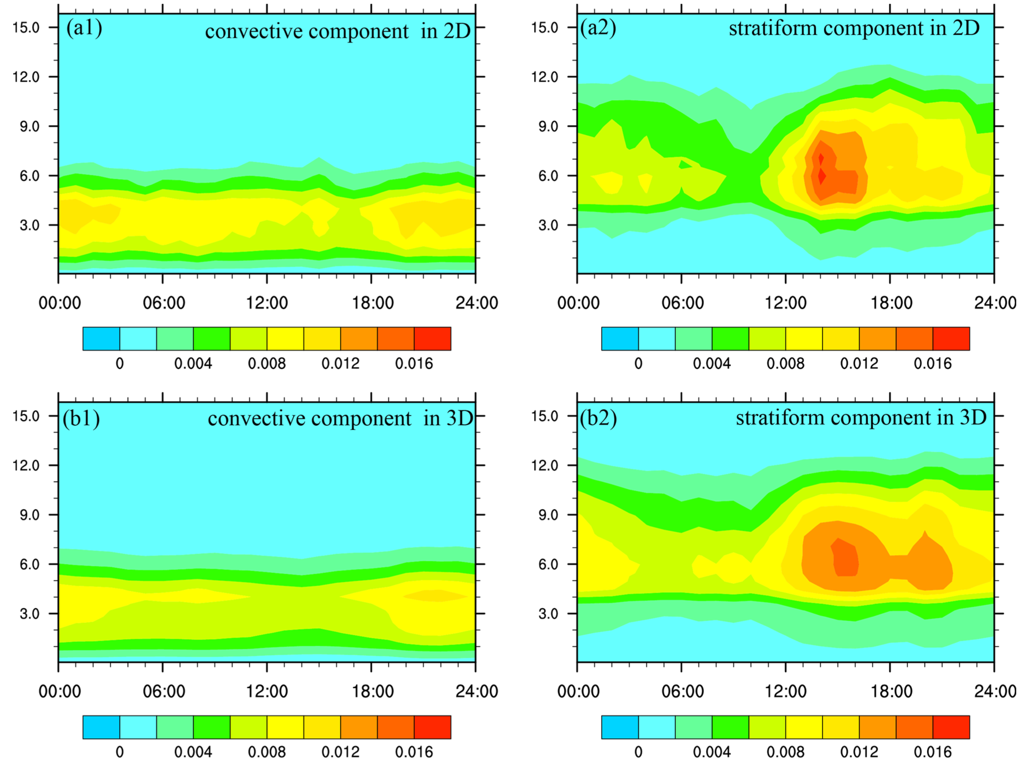
To investigate the impacts of stratiform and convective rainfall on diurnal cycles in the tropics, we separated IWP+LWP into convective and stratiform components and examined the diurnal variation in these components and PKE based on the 2D and 3D simulation results (
Figure 7 and
Figure 8). The similarities in the diurnal cycle of IWP+LWP between the 2D and 3D model results in convective and stratiform regions indicated that (1) much higher IWP+LWP and PKE values could be obtained in the stratiform regions in the afternoon than in the morning, while maxima occurred in the afternoon in the lower troposphere. The afternoon rainfall peak in the stratiform regions may be attributed to surface warming due to the absorption of shortwave solar radiation as a result of the unstable atmosphere associated with the accumulated unstable energy. (2) Much higher IWP+LWP and PKE values were attained in convective regions during the night than during the daytime, while maxima emerged at midnight in the middle troposphere and upper troposphere. The nighttime peak in the convective region could be attributed to surface cooling via the emission of longwave infrared radiation as a result of decreased saturation mixing ratios associated with increased water vapor mixing ratios [
62,
63,
69]. The differences revealed that the IWP+LWP and PKE values in stratiform regions were much lower in the 2D results than in the 3D results. In contrast, the values in convective regions were higher in the 2D simulation results than in the 3D simulation results.
Figure 7.
Diurnal composite of IWP+LWP (mm) in (a1) convective regions in the 2D model simulations and (a2) stratiform regions in the 2D model simulations, and diurnal composite of IWP+LWP (mm) in (b1) convective regions in the 3D model simulations and (b2) stratiform regions in the 3D model simulations.
Figure 8.
Diurnal cycle of the perturbation kinetic energy (J m−2) in the 2D model runs in (a1) convective regions and (a2) stratiform regions, and the perturbation kinetic energy in the 3D model runs in (b1) convective regions and (b2) stratiform regions.
Figure 8.
Diurnal cycle of the perturbation kinetic energy (J m−2) in the 2D model runs in (a1) convective regions and (a2) stratiform regions, and the perturbation kinetic energy in the 3D model runs in (b1) convective regions and (b2) stratiform regions.
The condensation and deposition related to the IWP and LWP can be determined by secondary circulation, whereas secondary circulation was quantitatively measured by PKE following Li et al. [
67], Xu and Li [
49], Peixoto and Oort [
70], and Barnes and Thompson [
71]. Thus, the diurnal cycle of the IWP and LWP can be measured by the diurnal variations of PKE, as showed in
Figure 9 and
Figure 10.
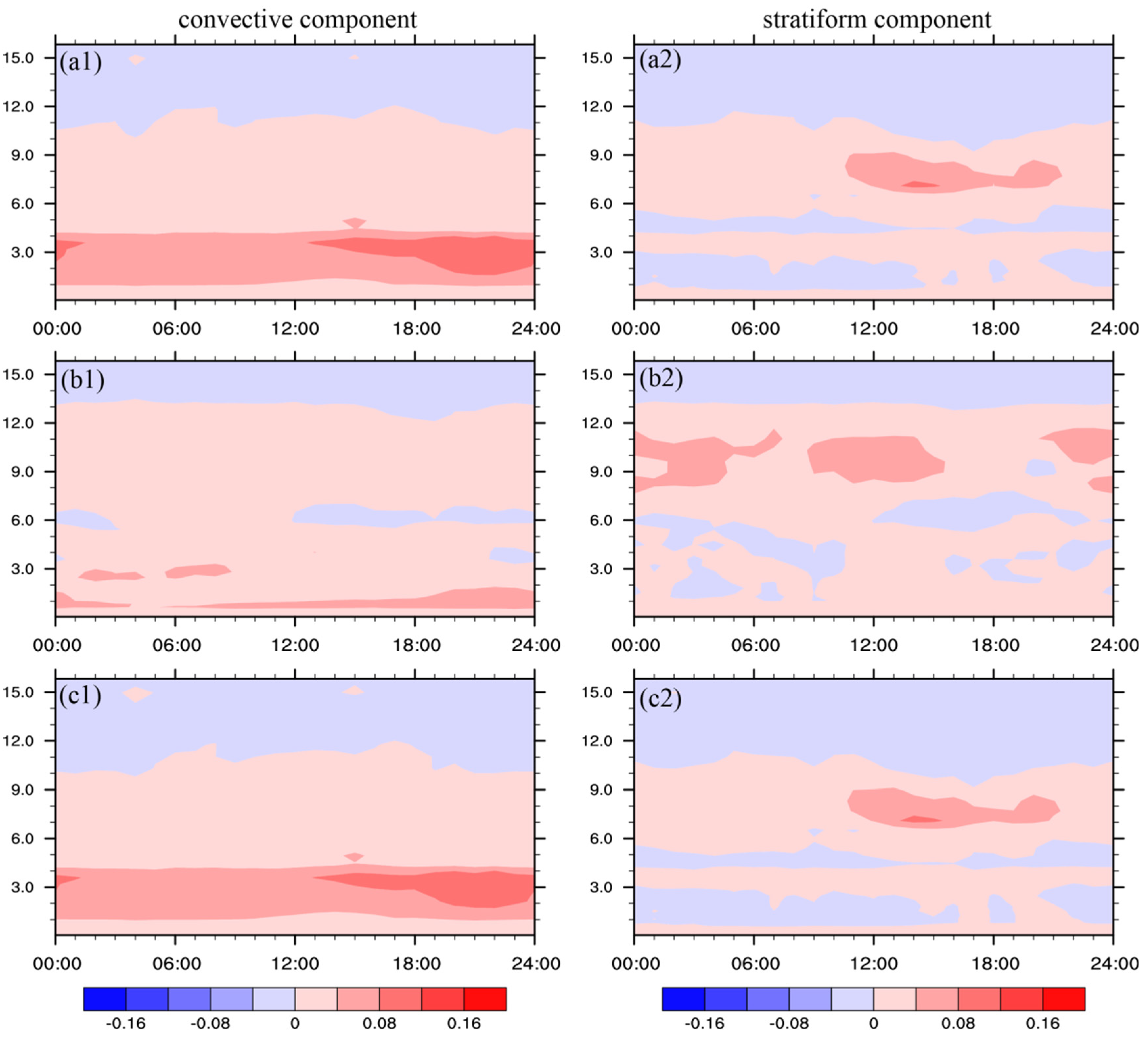
Figure 9 and
Figure 10 show diurnal cycle of (a) the tendency of the PKE, barotropic conversion, and baroclinic conversion in the 2D and 3D model runs in stratiform and convective regions. The maximum PKE in stratiform areas could be mainly linked to baroclinic conversion in the middle troposphere and upper troposphere. In convective regions, the maximum PKE was primarily linked to baroclinic conversion in the lower troposphere in both the 2D and 3D model results. These differences in the baroclinic conversion effects in convective (middle troposphere) and stratiform (upper troposphere) regions indicate that the maximum IWP+LWP and PKE values were more smoothly distributed in time and space in the 3D simulation results than in the 2D simulation results; the IWP+LWP values show more perturbations and vary less smoothly in time and space in the 2D simulations than in the 3D simulations (
Figure 4). They were also distributed over a larger range in the 2D simulations than in the 3D simulations (
Figure 5). The spatially and temporally scattered distribution of IWP+LWP and PKE support the conclusion that more notable physical fluctuations occurred in the 2D model results than in the 3D simulation results obtained by Zeng et al. [
41].
Figure 9.
Diurnal composite of (a1, a2) the tendency of the perturbation kinetic energy (), (b1,b2) barotropic term (), and (c1,c2) in the 3D model runs in (a1,b1,c1) convective regions and (a2,b2,c2) stratiform regions. The units are 10−1 J m−2s−1 for the barotropic conversion term and J m−2s−1 for the other terms.
Figure 10.
Diurnal composite of (a1,a2) the tendency of the perturbation kinetic energy (), (b1, b2) barotropic term (), and (c1, c2) in the 2D model runs in (a1,b1,c1) convective regions and (a2,b2,c2) stratiform regions. The units are 10−1 J m−2s−1 for the barotropic conversion term and J m−2s−1 for the other terms.
The previous analysis of IWP+LWP implies that the nighttime peak of IWP+LWP may be associated with IWP+LWP in both convective and stratiform regions, while the afternoon peak may be mainly related to that in stratiform regions. The nighttime IWP+LWP peak is associated with IWP+LWP in convective and stratiform regions, whereas the afternoon IWP+LWP peaks were mainly related to the IWP+LWP values in stratiform regions. This result is generally similar to that concluded by Sui et al. [
72]. Further water vapor mixing ratio and temperature analyses revealed that the high IWP+LWP and PKE values in the lower troposphere in the afternoon were associated with the high temperature and humidity in the lower layer of stratiform regions in both the 2D and 3D simulations (
Figure 11(b1,b2) and
Figure 12(b1,b2)); the afternoon peak may be associated with the enhancement of atmospheric instability in the afternoon in the stratiform region, as shown in
Figure 12(b1,b2). The typically shallow and warm mixed layer during the daytime shown in Yang and Slingo [
69], Sui et al. [
72], and Chen and Houze [
73] may be not be adequate enough to explain the afternoon peak. This high temperature and humidity in the afternoon may be associated with the increase in atmospheric instability at night in the convective regions, as shown in
Figure 12(a1,a2). The vertical transport of heat and moisture at the top of the planetary boundary layer mentioned by Wang et al. [
74] may not be adequate enough to explain the nighttime peak. The high IWP+LWP and PKE values in the lower troposphere at night were mainly associated with the high humidity and temperature in both 2D and 3D simulations and were the result of peak rainfall at night (
Figure 11(c1,c2) and
FIgure 12(c1,c2)). The nighttime rainfall regions are characterized by a warm and humid lower troposphere, since infrared radiation increases the cooling effect of a longwave infrared radiation release at the top, while the warming effect at the bottom of the atmosphere is attributed to the cloud trap in the lower layer during the nighttime, as indicated by other studies by Sui et al. [
62] and Sui et al. [
72].
Figure 11.
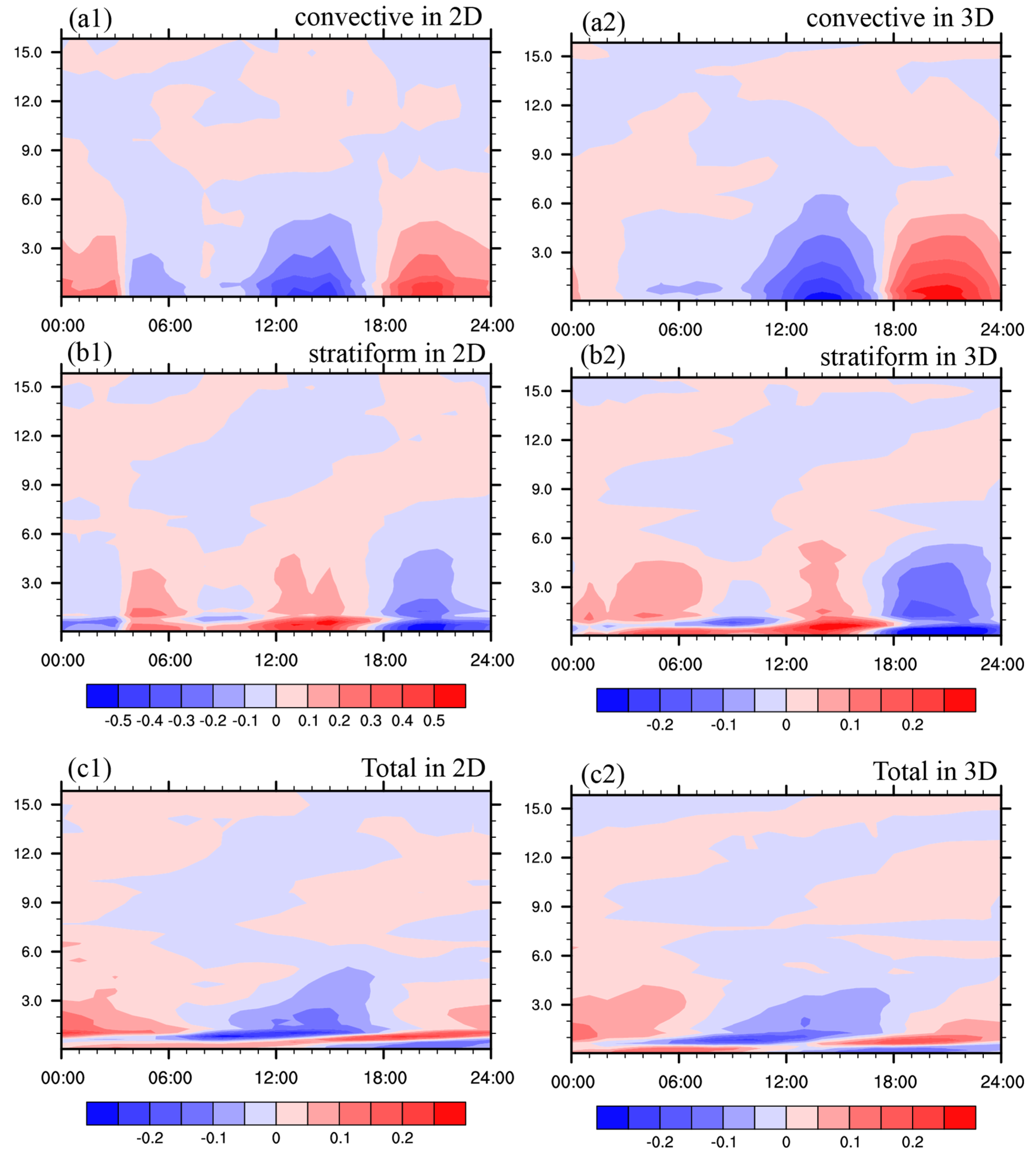
Diurnal composite of the perturbed water vapor mixing ratios (g kg−1) in the 2D (left panel) and 3D (right panel) model runs in (a1,a2) convective regions, (b1,b2) stratiform regions, and (c1,c2) the model domain. The perturbed values are calculated by subtracting the average water vapor mixing ratios.
Figure 12.
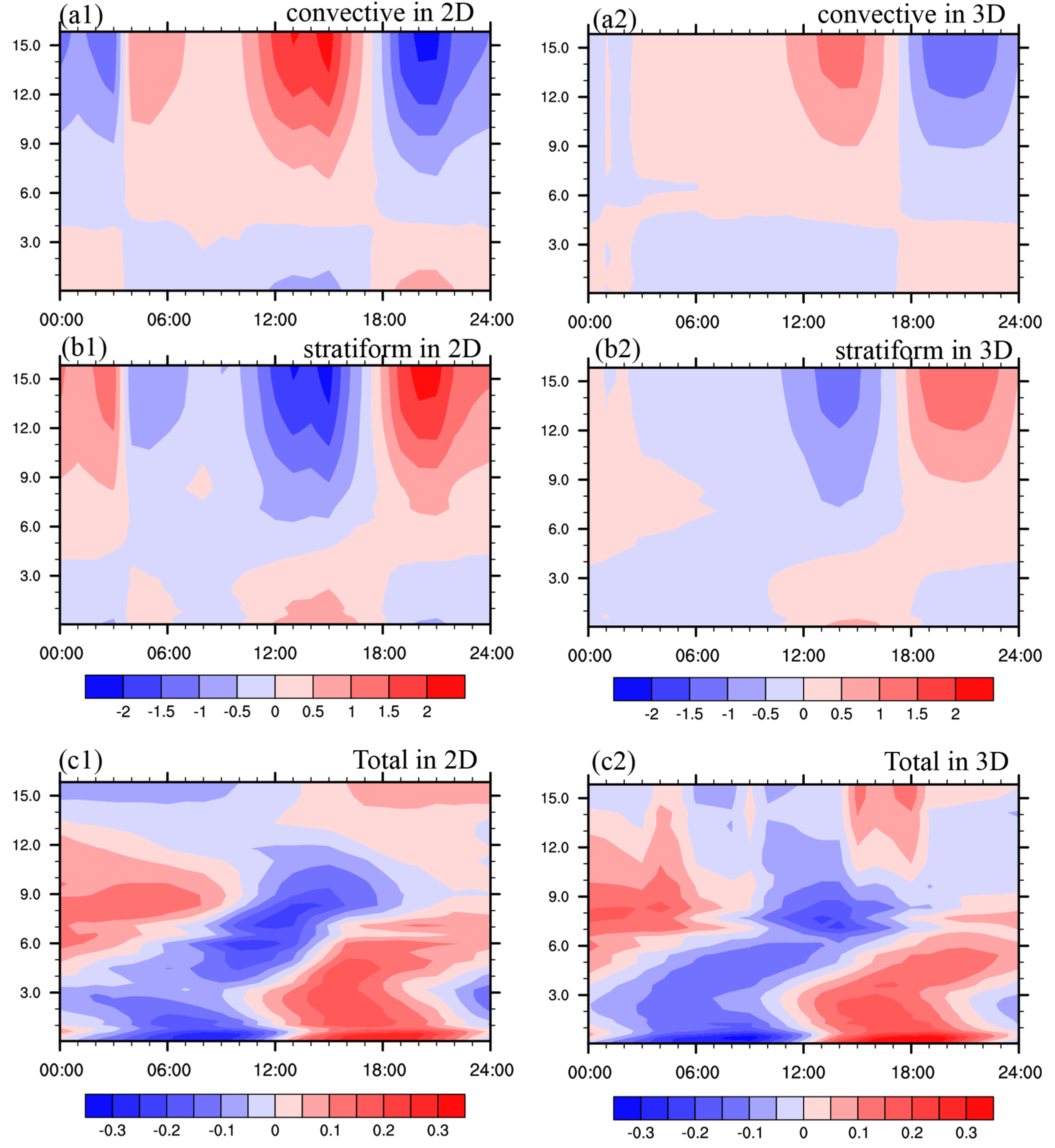
Diurnal composite of the perturbed temperature (°C) in the 2D (left panel) and 3D (right panel) model runs in (a1,a2) convective regions, (b1,b2) stratiform regions, and (c1,c2) the model domain. The perturbed values are calculated by subtracting the average temperature.
Figure 12.
Diurnal composite of the perturbed temperature (°C) in the 2D (left panel) and 3D (right panel) model runs in (a1,a2) convective regions, (b1,b2) stratiform regions, and (c1,c2) the model domain. The perturbed values are calculated by subtracting the average temperature.
4. Conclusions
The diurnal cycle of cloud processes was investigated based on the PKE budget using 2D and 3D CRMs during the KWAJEX period. The diurnal cycle in the 2D and 3D model results revealed similar variations. The analysis results indicated that much higher IWP+LWP and PKE values could be attained in the afternoon and at midnight than in the morning; this is consistent with the land-side regime in coastal areas showing rainfall propagation towards land with peaks continuing from noon to night, as reported by Kikuchi and Wang (2008) [
15]. The maximum IWP+LWP value in the 2D simulations occurred in the afternoon, whereas the maxima in the 3D simulations emerged at night.
The diurnal cycle of cloud processes revealed by IWP+LWP in the 2D CRM and 3D CRM simulations was impacted by the diurnal cycle of PKE. Mean background circulation can be quantitatively measured by mean kinetic energy, while secondary circulation can be measured by perturbation kinetic energy [
67,
68,
70,
75]. On the one hand, the conversion between background circulation and secondary circulation may affect convection in the tropics, as indicated by previous studies [
49,
71]; on the other hand, secondary circulation related to convection can be quantified by perturbation kinetic energy [
67,
76]. While the rainfall diurnal cycle in the tropics is generally characterized by early-morning peaks related to organized convection, afternoon convection is related to shallow convection and nocturnal convection is related to deep convection [
62,
69,
72]. Thus, the diurnal cycle of rainfall can be affected by convection associated with secondary circulation, which can be quantified by perturbation kinetic energy. Thus, PKE was also analyzed in this study.
Further PKE analysis demonstrated that PKE was predominantly determined by baroclinic conversion via the covariance between the perturbed vertical wind speed and water vapor, the temperature of dry air, and mixing ratios of cloud hydrometeors in the 3D and 2D model runs. Baroclinic conversion exhibited higher values in the afternoon and at midnight than in the morning. Maxima emerged in the afternoon, especially in the middle troposphere, leading to higher PKE values in the afternoon and at midnight than in the morning, with maxima occurring in the afternoon. Analysis of the convective and stratiform components of IWP+LWP and PKE exhibited similar trends. The maximum PKE value in stratiform regions was mainly associated with baroclinic conversion in the middle troposphere and upper troposphere in the afternoon and at night. The convective component was linked to baroclinic conversion in the lower troposphere during the nighttime in both the 2D and 3D model runs. The diurnal cloud cycle between the 3D and 2D model results revealed disparities. Further temperature and water vapor mixing ratio analysis revealed that the high IWP+LWP and PKE values in the lower troposphere at night were mainly associated with the high temperature and large relative humidity in convective regions at the bottom of the troposphere in both the 2D and 3D simulations. The warm and moist lower troposphere in convective regions could be explained as follows: the predominantly infrared radiation could facilitate top cooling and a warm lower troposphere in convective regions at night by Kikuchi and Wang [
15], Chen et al. [
77], and Al-Mutairi et al. [
78]. A warm and humid lower layer could lead to an unstable troposphere and stronger upward motions in convective regions at night.
The high values in the middle troposphere and upper troposphere in the afternoon in stratiform regions were linked to warm and humid conditions at lower levels and dry and cold conditions at higher levels in both the 2D and 3D simulations. Stratiform regions were characterized by a warm lower layer and cold high layer since solar radiation was trapped by the clouds, and longwave radiation was emitted from high clouds towards the surface and may have also included responses to the unstable atmosphere associated with accumulated unstable energy; these regions were also characterized by a humid lower layer, which may have occurred because of the vertical transport of heat and moisture due to turbulence mixing in the afternoon [
74]. Though the 2D and 3D CRM simulations show some similarities as above, there are still some differences.
This paper compared the diurnal cycle of clouds based on PKE budgets using 2D and 3D CRM simulations. The comparison between 2D and 3D CRM simulations is necessary to elaborate on differences and similarities. Presently, 2D CRMs are still used in many studies [
79,
80,
81,
82,
83,
84], and some of those studies consider that 2D and 3D CRM simulations are similar to each other and believe that 2D CRM results can represent 3D CRM results [
79,
82]. This study shows that the diurnal variations in PKE, baroclinic conversion, and IWP+LWP reveal scattered distributions in 2D CRM simulations. This suggests that ice water and liquid water fluctuated more frequently in both time and space in 2D simulations than in 3D simulations. In the 3D model runs, area-averaged kinetic energy was transformed into PKE. In the 2D model runs, PKE was more notably converted into area-averaged kinetic energy. PKE in 2D is significantly larger than that in 3D, because the convergence related to the upward motions can only occur horizontally in a zonal direction, leading to larger zonal winds and vertical upward motions [
49,
67,
76,
81]. The difference between the 2D and 3D CRM simulations may be associated with energy transfer with different scales [
85,
86] and buoyancy damping [
41]. The exclusion of longitudinal winds in the 2D model compared to the 3D model may account for the strong vertical oscillation in the 2D CRM simulations. The incorporation of longitudinal winds in the 3D model runs could lead to greater instability since a higher area-averaged kinetic energy was converted into PKE, indicating that the effect of the asymmetric structure of horizontal winds on the diurnal cycle of tropical clouds is essential. Two-dimensional CRM simulation shows more intense vertical oscillations than three-dimensional CRMs, and this may also affect clouds via microphysical processes [
41]. This is the result of more fluctuations in the clouds, revealed by the frequent variations in IWP+LWP in temporal and spatial distribution. Additionally, clouds in 2D CRM simulations may develop more quickly from shallow convection to deep convection [
64,
65,
66].
Special caution may be exercised when applying the results, since we draw the conclusions using the analyses of ice water and liquid water path from the simulations and TRMM results, whereas the comparison of hydrometeors between simulations and TRMM 2A12 data shows that snow content and cloud cover were underestimated above the melting level. This may imply that the numerical model may underestimate cloud cover above melting level, and it may not properly simulate the growth of snow from cloud ice. The underestimation of snow may lead to underestimation of ice water path (IWP) in both 2D and 3D CRM simulations [
60,
87,
88]. Another possibility is that the TRMM 2A12 datasets may not properly reproduce ice water contents due to the imperfect methods, as indicated by the other literature [
89,
90]. Further examinations of more observations should be used to validate and generalize the results from this study.
