Abstract
Glaciers are an important part of the cryosphere and important reservoirs of fresh water on Earth. Glaciers in the Gongga Mountains, located in the southeastern Tibetan Plateau, have been experiencing dramatic changes and substantially shrinking over the past two decades. We analyzed the glacier change over the Gongga Mountains using the Landsat data from 1994 to 2021 (interval of 4 or 5 years), with Gaofen-1 (GF-1) data to evaluate the uncertainty. The glacier shrinkage under different terrain conditions, including altitudes, slope, and slope direction, was further explored. Finally, we evaluated the response of glacier shrinkage to climate change using precipitation and temperature data for nearly 30 years. Results show that the glaciers in the Gongga Mountains are experiencing an accelerating ablation, with a glacier area of ~240 km2 in 1994 and ~212 km2 in 2021 (an average annual shrinkage rate of 1.04 km2/a). The shrinkage mainly occurs in areas with altitudes of 5000–5300 m and a slope of 30–40°. Moreover, the shrinkage is strongly related to the recent warming of the climate, with the warming rate being 0.19 °C/10a, while precipitation remains almost constant during 1978–2019. The results provide a scientific basis for water resources management, ecological environmental protection, and natural disaster protection in southeast Tibet for decision making.
1. Introduction
Glaciers are flowing bodies of ice formed by the accumulation of snowfall and other solid precipitation on the surface of polar or alpine regions. They are important components of the cryosphere and reservoirs of freshwater on Earth, which have seasonal and cyclical regulating effects on water resources, for example, regional runoff [1]. The rate of sea level would have risen about 0.74 ± 0.04 mm/a from 2000 to 2019 if all glacial meltwater flowed into the ocean [2]. By the end of this century, about 200 million people will live on land that is predicted to fall below the high-tide lines of rising sea levels [3]. Within the next 30 years, more than 1 billion people could face water scarcity and food shortages [4]. Considering global warming, glaciers, as one of the most sensitive indicators of climate change, are important to studies of climate change, surface water change, and glacial natural hazards.
Glacier boundary extraction is then critical to support these studies, which consists of two categories [5]. One is the visual interpretation with high accuracies, which is time-consuming and labor-intensive. The other is the automatic extraction by computer with high time efficiency and less labor effort, for example, the band ratio method [6] and supervised classification [7]. However, the latter one generates considerable errors and thus cannot effectively identify glaciers covered by snow, ice, and debris. Additionally, it has been limited to specific regions despite various research [8,9]. Combining automatic computer extraction and visual interpretation is then becoming a more effective way of extracting glacier boundaries.
Based on rapidly developing remote sensing technologies, the remotely sensed data are extensively used to support this method to analyze glacier area changes, such as Landsat Multispectral Scanner (MSS)/Thematic Mapper (TM)/Enhanced TM+ (ETM+)/Operational Land Imager (OLI) satellite data [10,11,12], Advanced Spaceborne Thermal Emission and Reflection Radiometer (ASTER), Advanced Land Observation Satellite (ALOS), Satellite pour l’observation de la Terre-5 (SPOT), Quickbird, IKONOS, China & Brazil Earth Resource Satellite (CBERS), and Sentinel series satellite data [13,14,15,16,17,18,19]. Gaofen (GF) satellite series is the high-resolution satellite for China’s High-resolution Earth Observation System (CHEOS) program [20]. The Gaofen-1 (GF-1) is the first satellite of the CHEOS program and was launched in 2013. The return period of the GF-1 satellite is 4 days, which compensates for the data window of Landsat (16 days). The higher spatial resolution of the GF-1 satellite (16 m) also allows for better visual interpretation. It can reach a width of 800 km which is the widest among international cameras with similar resolution, realizing the combination of resolution and large width [21]. Previous research offered remarkable examples using this data [22,23,24] that are highly recommended to be adopted.
The Gongga Mountains are the largest development center of the oceanic glacier group at the southeastern edge of the Tibetan Plateau, except for southeastern Tibet and the central-eastern part of the Nyingchi Tanggula Mountains [25]. The Gongga Glaciers are monsoonal-marine warm glaciers with plentiful glacial water resources as their high meltwater discharges are formed under the influence of a monsoonal-marine climate [26]. The glaciers in the Gongga Mountains have recently shown an apparent trend of retreating areas, rising snowline, and decreasing ice reserves. Since the last century, the glacial, meteorological, hydrological, and geological investigations and observations of the Gongga Mountains have been comprehensively analyzed [27,28,29,30,31,32,33,34,35]. Pan et al. [31] extracted glacier boundaries in the Gongga Mountains region based on remote sensing imagery for investigating their response to climate change in conjunction with GPS data. The results showed that the total glacier area of the Gongga Mountains decreased by 29.2 km2 from 1966 (257.7 km2) to 2009 (228.5 km2), accounting for 11.3% of the total area in 1966. The loss of the most severe glaciers is in areas with an elevation of 5100–5300 m and >5700 m and/or the slopes of 15°–20° and 35°–40°. Shi et al. [35] analyzed the relationship between the extracted glacier boundaries of the Gongga Mountain region and climate change using remote sensing imagery from 1989 to 2017. It concluded that the total glacier area decreased by 24.67 km2 from 1989 (238.39 km2) to 2017 (213.72 km2), accounting for 10.13% of the total area in 1989. The most severe glacier loss occurs in the southern slopes and 5100–5200 m elevation area, and/or with a slope of 30°.
Global glacier loss has been accelerating since the beginning of the 21st century due to global warming [2]. A spatially explicit understanding of the loss in the Gongga Mountain region remains to be extended despite previous research since the 21st century. Considering the vital role and superior performance of the Chinese GF-1 satellite in glacier monitoring [24,36], this paper used the GF-1 data to generate the glacier boundary and assess the uncertainty of the Landsat-derived boundary. The primary objectives of this work were: (1) extracting the glacier boundaries by combing the band ratio method and visual interpretation; (2) analyzing the glacier changes under different terrain characteristics in conjunction with the remotely sensed data and ASTER Global Digital Elevation Model (GDEM); (3) exploring the response of glacier shrinkage to climate change through meteorological data. The use of GF-1 data is expected to increase the accuracy of uncertainty evaluation of glacier area extraction and efficiently explore the long-term glacier change to achieve a comprehensive and broad view of glacier shrinkage characteristics over the Gongga Mountain region. Furthermore, this would be helpful to explore the response law of the glacier shrinkage and the climate change. The results as a scientific basis do not only potentially benefit decision making for water resources management, ecological environmental protection, and natural disaster protection in the southeast Tibetan Plateau, but also, support glacier change studies in similar regions.
2. Materials and Methods
2.1. Study Area
The Gongga Mountain region (29°20′–30°10′ N, 101°40′–102°15′ E) is located at the southeastern edge of the Tibetan Plateau. It has the highest peak in the Hengduan Mountains region at 7514 m above sea level and features 74 modern glaciers and a total area of 255.1 km2 in 1966 [37]. The region geologically belongs to the western edge of the connecting zone between the Qinghai-Tibet and Yangzi plates. Since the Quaternary period, active neotectonic movement and very strong uplifts of differential fault blocks occurred in the region. The huge mountain masses placed above the snow line (4800–5200 m) created conditions for the development of modern glaciers at low temperatures [38].
The Gongga glacier is a monsoon marine warm glacier with a temperature of nearly 0 °C. It is higher than the “cold glacier” (usually below −10°) formed under continental climate conditions. Its climate is mainly affected by the southwest monsoon, southeast monsoon, and high-altitude westerly winds [38]. The average annual temperature near the glacier snow line (4800–5000 m) on the eastern slope of the region is from −4.8 to −4.1 °C, while the average annual temperature near the glacier snow line (5000–5200 m) on the western slope is from −5.0 to −4.1 °C [34].
2.2. Data
The data (Table 1) includes remotely sensed data, Digital Elevation Model (DEM) data, meteorological data, and Randolph Glacier Inventory (RGI) 6.0 data. The remotely sensed data and the DEM data were used to analyze glacier change under different geographical features. The meteorological data were used to explore the response of the glacier to climate change. The RGI 6.0 data contributed to accurately extract the glacier boundary.

Table 1.
Detailed information on the data used in this study.
2.2.1. Remotely Sensed Data
Landsat data are vital to glacier research because of their long time series, easy access, and high accuracies [39,40,41]. GF-1 data has also been widely used due to its high resolution, short regression period, and wide coverage area [42,43]. Combining these two data could improve the extraction accuracy of the glacier boundary over the Gongga Mountains.
The Landsat products were acquired from Landsat5, Landsat7, and Landsat8, with the sensors TM, ETM+, and OLI, respectively. The data selection rule of low cloudiness and less snow is to be followed to reduce the influence of extraneous elements. Images at the end of the glacial ablation period are selected as much as possible. A total of 12 images of Landsat from 1994 to 2021 were selected and the detailed information is shown in Table 2.

Table 2.
Detailed information on Landsat images used in this study.
The GF-1 satellite is the first star in the space-based system of China’s high-resolution Earth observation system special project. The satellite carries two panchromatic (2 m resolution) multispectral cameras (8 m resolution) and four multispectral wide-width cameras (16 m resolution). The GF-1 data corresponding to the years of Landsat data were selected (Table 3). Moreover, to reduce the influence of snow and cloud on the extraction accuracy, priority was given to images with low cloudiness and at the end of the glacier ablation period. These image data are radiometrically corrected products (Class 1A products) with a spatial resolution of 16 m.

Table 3.
GF-1 image information list.
2.2.2. ASTER GDEM Data
The ASTER GDEM (https://search.earthdata.nasa.gov/search (accessed on 6 July 2022))) was generated by automating the acquisition of vertical and rear-view stereo images by an advanced optical sensor carried by NASA’s Terra satellite that was launched in December 1999. The data covers from 83° S to 83° N with a spatial resolution of 30 m [44]. The ASTER GDEM data has three versions so far, i.e., Version 1 (V1), Version 2 (V2), and Version 3 (V3). ASTER GDEM V1 was released on 29 June 2009. The newest V3 data was released on 5 August 2019. Compared with ASTER GDEM V1, the V3 data has been filling in blank areas and correcting for outliers in the waters. ASTER GDEM V3 was acquired from 1 March 2000 to 30 November 2013 and was used to extract the terrain attributes.
2.2.3. Meteorology Data
Earlier research reported that the increasing temperature was the root cause of glacier retreat [45,46,47], while changes in precipitation have greater impacts on glacier accumulation. To investigate the response of the glacier to climate change, the temperature and precipitation data were obtained.
The monthly temperature data at 1 km spatial resolution were generated by the Delta downscaling method based on the global 0.5° climate dataset published by using Climatic Research Unit (CRU) and the global high-resolution climate dataset published by WorldClim [48]. The CGDPA is developed by the China Meteorological Administration (CMA) that generates daily continuous precipitation using a climatological optimal interpolation algorithm and precipitation data from 2419 gauges [49]. These two gridded data with relatively higher accuracies have been previously validated and widely used in China [48,50].
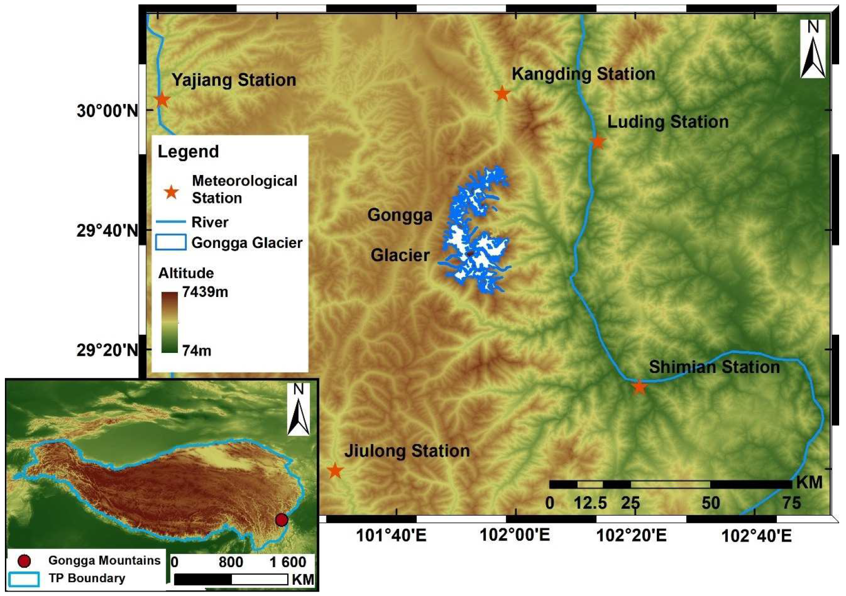
To further verify the reliability of the above gridded temperature and precipitation data, the daily gauge data (i.e., temperature and precipitation) during 1988–2017 from five stations (Table 4) near the Gongga Mountains region (Figure 1) were obtained from the China Meteorological Science Data Sharing Service. The gauge data were first assigned to the nearest grid cell. The values of each gridded precipitation and temperature data for the corresponding grid cell were then extracted [51]. The correlation coefficients (CC) for each station were calculated using gridded data and gauge data. Better performances of CGDPA (CC > 0.70) and temperature (CC > 0.75) demonstrated high suitability for using them to assess climate change (Figures S1 and S2 in the Supplementary Materials).

Table 4.
Information on meteorological observation sites.
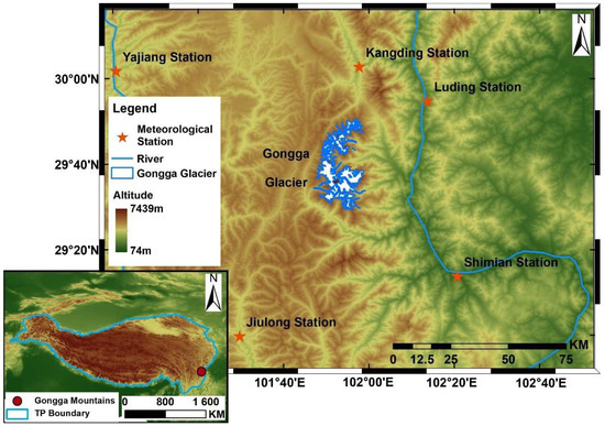
Figure 1.
Location of the study area and distribution of meteorological stations.
2.2.4. RGI Data
RGI was derived from the Global Land Ice Spatial Survey (GLIS) program launched in 1999, with a joint initiative of NASA and the U.S. Geological Survey (USGS). RGI is a global catalogue of glaciers, developed using Landsat and ASTER imagery as the primary remotely sensed data source to document glaciers worldwide. The RGI data is the only publicly available glacier inventory covering the entire Tibetan Plateau [52]. The latest version, RGI 6.0, was released in July 2017 (http://www.glims.org/RGI/ (accessed on 6 July 2022)) and included the second glacier cataloging data for China.
2.3. Methods
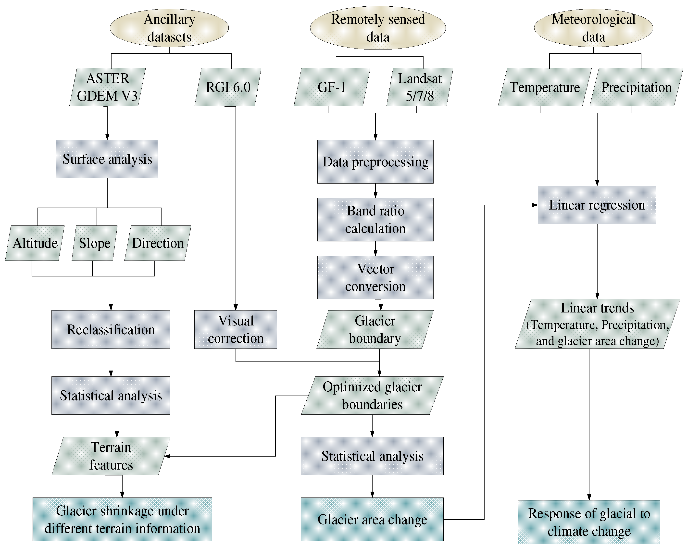
The research was conducted in three steps (Figure 2). First, the band ratio method was used to extract glacier boundaries from Landsat and GF-1 images after data preprocessing. Then, the images were optimized using RGI 6.0 data. Second, the elevation, slope, and slope direction were obtained from the ASTER GDEM V3 data and the glacier shrinkage under different terrain information was analyzed. Last, the response of the glacier to climate change was explored by using temperature and precipitation data.
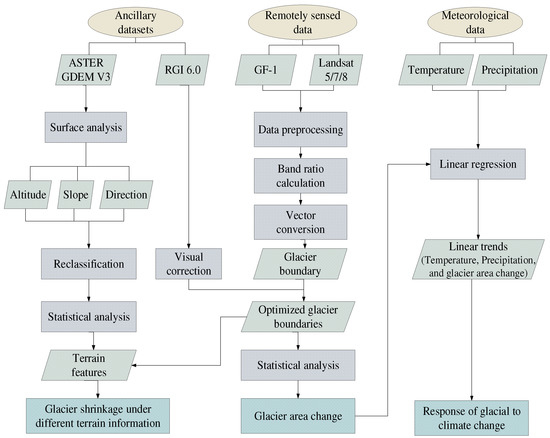
Figure 2.
The flow chart of this work.
2.3.1. Glacier Boundary Extraction
The determination of glacier boundaries is crucial to demonstrate the spatial and temporal characteristics of glacier variability. This paper used Landsat images, GF-1 images, and RGI glacier cataloging data to extract and optimize the glacier boundaries over the Gongga Mountain region. The images were first pre-processed by radiometric calibration, atmospheric correction, and geometric correction. Radiometric calibration was used to convert pixel values to reflectance values using conversion coefficients in the metadata file [53]. The fast line-of-sight atmosphere analysis of spectral hypercubes (FLAASH) model was used for the atmospheric correction [54]. Parameters required by the model were acquired from the header files of image data and the Litang station (29.976N, 100.262E) from the Aeronet network (e.g., aerosol optical depth). The GF-1 images were geometrically corrected based on the Landsat data at an accuracy of fewer than 0.5 pixels (root mean square error (RMSE)). The band ratio method was subsequently conducted to supervise the classification of the satellite images (i.e., Landsat and GF-1 data) into glaciers and non-glacier areas. The glacier boundaries were then optimized by visual interpretation aided by RGI glacier cataloging data.
The strong reflection of glaciers is in the red band (0.63–0.69 μm), while the strong absorption is in the short-wave infrared band (1.550–1.750 μm). The band ratio calculation was then conducted using Band 3 (red) and Band 5 (short-wave infrared) (i.e., Band 3/Band 5) for Landsat TM/ETM+ images, and Band 4 (red) and Band 6 (short-wave infrared) (i.e., Band 4/Band 6) for Landsat OLI images. The band ratio threshold was set as 2.25 since it has been extensively applied for glacier boundary extraction [55,56,57]. Note that the mean value of the range of 2.0 to 2.5 was used to distinguish glacial from non-glacial areas [58].
For the GF-1 image, the lack of a short-wave infrared band with strong glacier absorption hinges the traditional band ratio method. An earlier study showed that the blue band of the GF-1 satellite was the best for glacier identification [59]. The visible band (Band 1: 0.45–0.52 μm) and the near-infrared band (Band 4: 0.77–0.89 μm) were thus used to exact the glacier boundary [24]. The threshold value of the band ratio was set as 0.65, which could effectively distinguish between glacial areas including snow-covered areas (>0.65) and non-glacial areas (<0.65) [23,24,60].
The glacier boundary extracted from Landsat images contains the majority of glacier areas, while the boundary was rough and lost a lot of detail (Figure S3b). The GF-1 imagery, however, can better identify the debris-covered glaciers and obtain more detail of the glacier margin regions (Figure S3e). The RGI 6.0 data can provide the overall extent of the glacier but has a coarse spatial resolution (Figure S3c). A visual correction by manual editing of glacier boundaries was then performed to optimize the glacier boundary based on the Landsat-based glacier boundaries and RGI 6.0 data by eliminating the significantly protruding boundary and other typical contaminated areas (e.g., by clouds and snow) (Figure S3c). The GF-1 boundary was used to validate the Landsat-derived glacier boundary and assess its uncertainty. The high-precision glacier boundary (Figure S1f) was thus obtained to be used for the analyses.
2.3.2. Uncertainty of Glacier Boundary Extraction
The uncertainty of glacier boundary extraction comes from the quality and the spatial resolution of remotely sensed data, the error of visual correction, etc. [10]. Few factors (e.g., the visual interpretation error) are difficult to detect in order to be statistically analyzed. Assessing and combining all of the factors to determine the combined uncertainty value is then considerably complicated and almost impossible. To simplify the calculation, the uncertainties generated by the data quality and visual corrections could be neglected due to two reasons: (1) the satellite data were well processed before being released [61]; and (2) the visual corrections were performed by the same person to ensure consistent discrimination criteria for minimizing errors [62]. The uncertainty of glacier boundary extraction caused by the spatial resolution of remotely sensed images was then discussed according to the following formulas [63,64]:
where EAC is the glacier area change uncertainty; EA0 and EA1 are the uncertainties of the glacier area in two periods, which can be obtained as follows:
where EA is the glacier area uncertainty; N is the number of grid-cells passed by the glacier boundary of the images; and λ is the spatial resolution of the remote sensing image.
Furthermore, we have attributed the differences between Landsat and GF-1 images to the uncertainty of glacier boundary extraction. The final uncertainty of extracting glacier boundary from Landsat data (i.e., UF) can be obtained as follows:
where is the difference between the Landsat-derived glacier area and the GF-1-based glacier area. As the GF-1 data is available only in the partial period (from 2013 to 2021), not the whole period of the study (1994–2021), the mean value of the difference in the three years (i.e., 2013, 2017, and 2021) is used as the final value, which will be used to calculate the uncertainty for the study period.
2.3.3. Terrain Information Extraction and Trend Analysis
The ASTER GDEM data were used to extract the geomorphological features through the surface analysis function of the GIS platform, including the elevation, the slope, and the slope direction. The glacier shrinkage under different geographic features was then explored by combining geographic features and the change of glacier area.
The linear trend was estimated using a linear regression model, which can be expressed as follows:
where a is the regression coefficient; b is the regression constant; i is the serial number; is the time series data , i.e., temperature, precipitation, and glacier area data in this work. The coefficients of a and b can be estimated by a least square method as follows:
where n is the total number of data. The coefficient of a (i.e., slope) represents the linear trend, and a > 0 indicates an upward trend, while a < 0 means a downward trend. The magnitude of a reflects the rate of rises or falls trend. Combining the trend of glacier area change with the trends in precipitation and temperature, we explore the response of the glaciers to climate change.
3. Results and Discussion
3.1. Overall Evaluation of Glacier Change
Table 5 shows the glaciers’ change during 1994–2021 (interval of 4 or 5 years) over the region. The glaciers show a general decreasing trend from 1994 to 2021. The area was 240.10 ± 10.32 km2 (10.32 is the uncertainties as stated in Section 2.3.2, same hereinafter) in 1994 and shrank to 211.90 ± 14.70 km2 in 2021 (Figure S4 in the Supplementary Materials), with an average annual retreat of −1.04 ± 0.78 km2/a (F-test, p < 0.05). From 1999 to 2017, the glacier area shrunk by 18.51 ± 21.03 km2, with an average annual shrinkage rate of −1.03 ± 1.17 km2 (p < 0.05). This further confirms earlier results that the glacier area shrank by 17.03 km2 with an average annual change rate of −1.06 km2 during 2001–2017 [35]. Moreover, the glacier shrinkage rate shows a considerable increasing trend, especially in recent years (e.g., 2017 and 2021, see AASA in Table 5). During 2017–2021, the glacier retreat rate indeed reached a maximum of −1.71 ±5.20 km2/a, which is almost 3 times larger than the period from 1994–1999 (−0.55 km2/a). From 2013 to 2021, the total glacier area decreased by 13.09 ± 20.92 km2, with an average decrease rate of 1.64 ± 2.62 km2/a (p < 0.05).

Table 5.
Statistics of glacier area changes.
To further evaluate the glacier area extracted from Landsat data, we compared it with the area changes of GF-1 data in Table S1 in the Supplementary Materials. The GF-1-based glacier area is larger than the area generated by the Landsat data. The underestimation of Landsat data is mainly because the GF-1 imagery can better identify the debris-covered glaciers and obtain more details of the glacier margin regions. However, the annual absolute shrinking area rate (AASA) (e.g., −6.26/−5.81 of Landsat and GF-1, respectively) and absolute shrinking area (ASA) (e.g., 1.57/−1.45 of Landsat and GF-1, respectively) from the two data are similar. This demonstrates high confidence in using the Landsat data to explore the glacier change for later analysis. It should be noted that the large uncertainties for the ASA and the AASA (Table 5) are not astonishing, since the glacier area change in a short term (e.g., 4 or 5 years in this study) is relatively small and is not always larger than the uncertainties. This was confirmed by earlier studies [64,65,66,67,68,69,70,71].
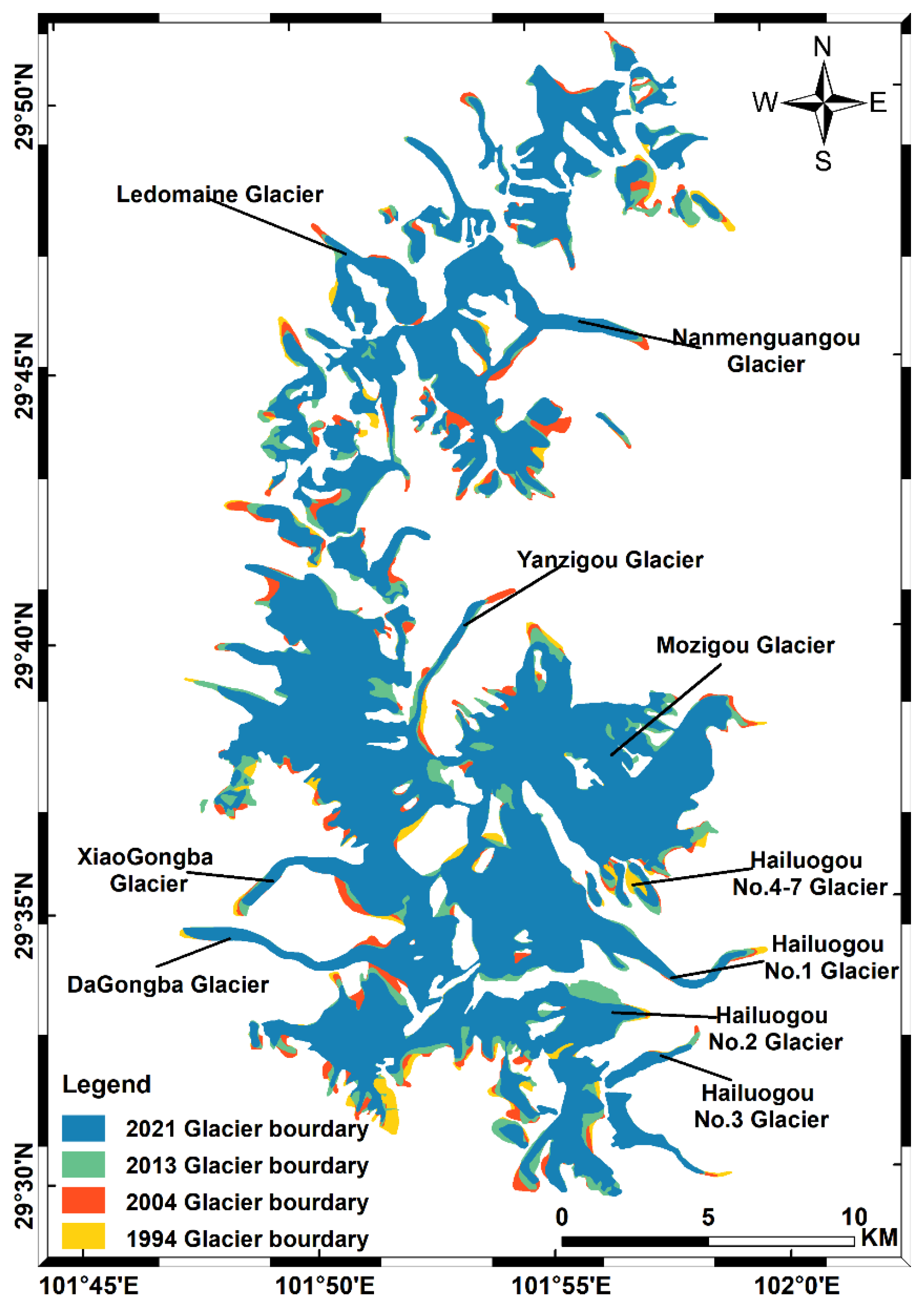
Figure 3 depicts glacier boundaries in 1994, 2004, 2013, and 2021. The reduction of glaciers generally occurred in all regions, e.g., in Hailuogou Glacier and Dagongba Glacier. From 2004 to 2013, the total shrinkage area of the Gongga Mountains glacier was 8.73 ± 21.16 km2, mainly occurring in the terminus of the glacier, like the Ledomaine, Nanmengguangou, Xiaogongba, and Yanzigou glaciers. The shrinkage also occurred in the interior and edge of the Mozigou and Hailuogou No. 2–3 glaciers. From 2013 to 2021, the glacier area shrank by a total of 13.09 ± 20.92 km2, including Mozigou, Xiaogongba, and Hailuogou No. 2–3 glaciers. In addition, Dagongba Glacier and Hailuogou No. 1 Glacier have remained nearly unchanged since shrinking from 1994 to 2004, while Hailuogou No. 4–7 Glacier shrank throughout the whole study period (i.e., 1994–2021).
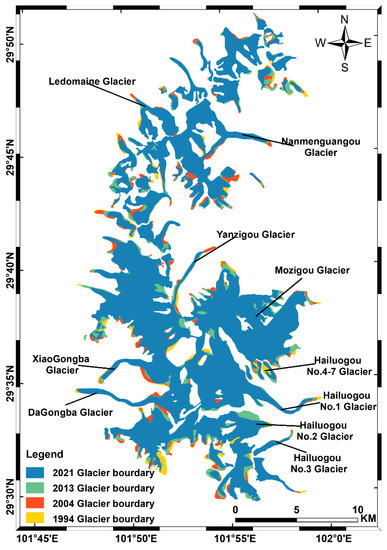
Figure 3.
The boundary of glaciers in 1994, 2004, 2013, and 2021.
3.2. Glacier Shrinkage under Different Terrain Conditions
3.2.1. Glacier Shrinkage at Different Altitudes
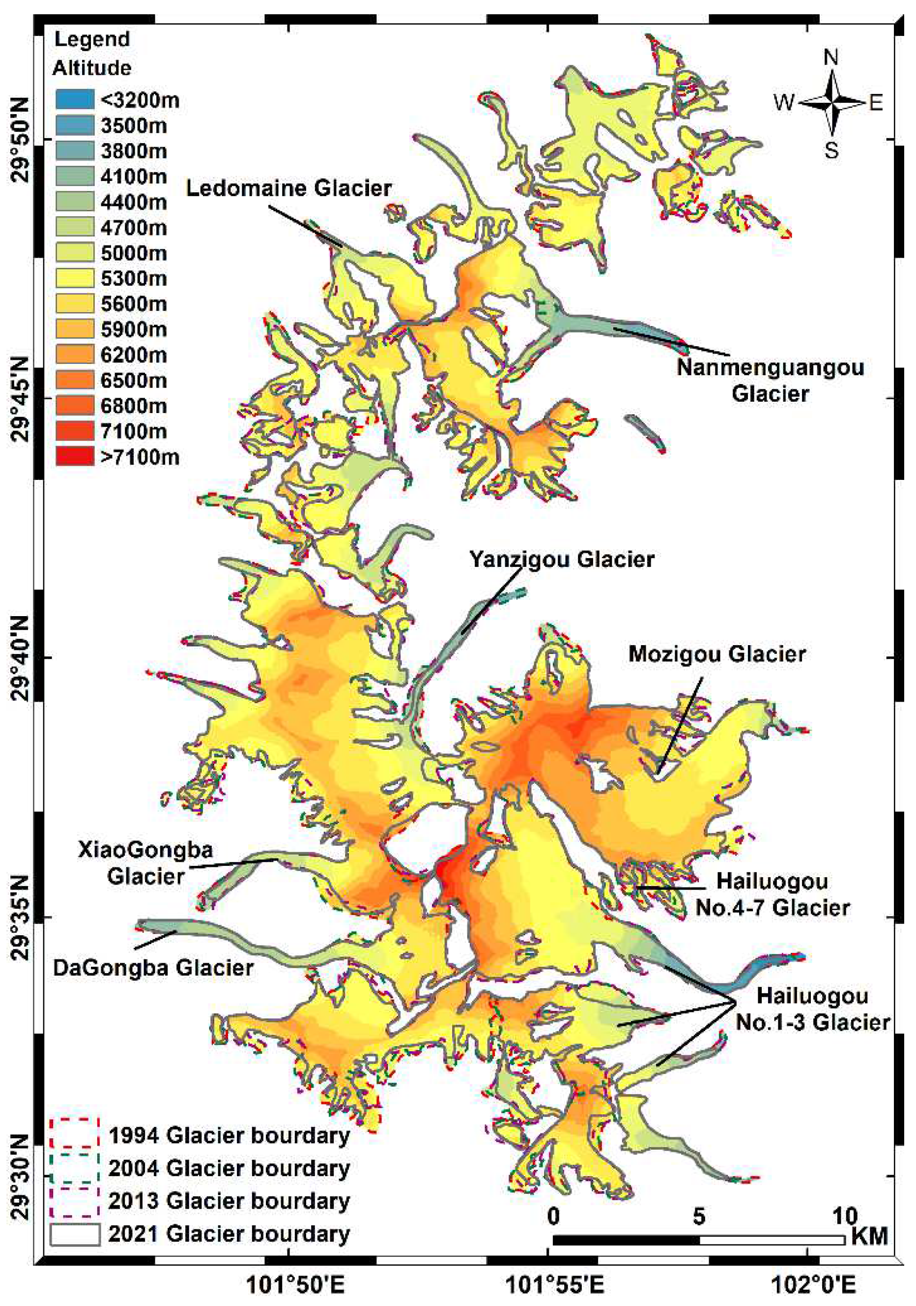
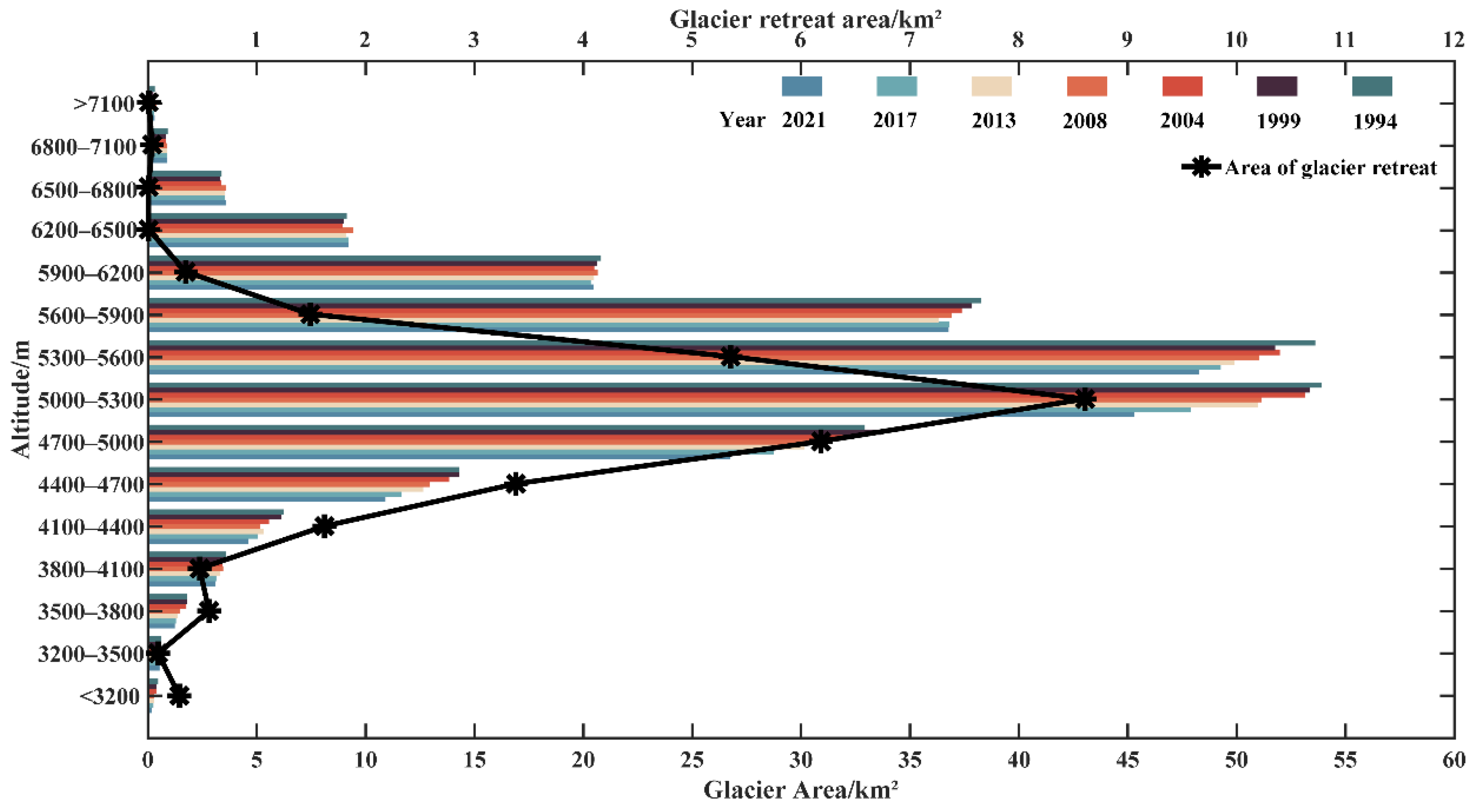
The DEM was divided into 15 elevation zonations at 300 m elevation intervals to comprehensively analyze the glacier shrinkage (Figure 4). The glaciers are generally located at altitudes ranging from 2940 m to 7473 m; however, most of them are located at altitudes lower than 6200 m over the Gongga Mountain region. The average elevation of glaciers in the southern area is higher than in the northern area. Additionally, the glacier’s shrinkage frequently occurs in areas below 5600 m altitude (e.g., the Dagongba Glacier and the Hailuogou Glacier), with the glacier area decreasing by 26.52 km2, accounting for 94.34% of the total glacier reduction (−28.11 km2 in Table 5) from 1994 to 2021.
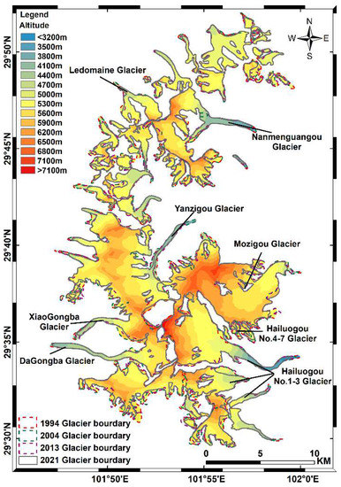
Figure 4.
Glacier distribution at different elevation zonations in 1994, 2004, 2013, and 2021.
The altitudinal distributions of glacier shrinkage highlight that the decline in Gongga glaciers is not obvious at high altitudes (over 5900 m). The average elevation of the glaciers on the west side of Mozigou Glacier is higher than in the east, while its shrinkage is not obvious. A small amount of shrinkage was detected in the marginal part of the area. Contrarily, the glacier shrinkage had a larger size at the middle (4400–5900 m) and low altitudes (below 4400 m) than that in high altitudes, like the terminus of the Hailuogou, Yanzigou, Daigongba, and Xiaogongba glaciers. This is because the snow line in the region is located at 4800–5200 m altitude [38] and the annual snowfall in the area below the snow line is less than the annual melting amount. As a result, the snowfall cannot compensate for glacier ablation and, therefore, a more obvious glacier shrinkage occurred in this region. Although glacial mass was transferred from the accumulation zone to the ablation zone in various ways, it was not enough to achieve a balance in the region. Moreover, the precipitation is impacted by the altitude. When the altitude reaches 3000 m, the precipitation decreases as the altitude rises, and then increases after reaching the altitude of around 5000 m [38]. The results demonstrated that the decrease in precipitation leads to a decrease in the accumulation rate of glaciers from 3000–5000 m altitude, which leads to more severe glacier shrinkage in the middle and low altitude areas to some extent.
Figure 5 shows the glacier area statistics at different elevation zonations in different years. The glaciers are mainly concentrated in the elevation range from 4700–5900 m, where the area accounts for more than 74% of the total glacier area from 1994 to 2021. Correspondingly, the area of glacier retreat peaks at 5000–5300 m altitude in the region, with a total retreat area of 8.61 km2 and accounting for 30.63% of the total glacier shrinkage area. At altitudes lower than 4100 m and higher than 6500 m, the glacier has the smallest area, accounting for about 4.50% of the total glacier. At elevations higher than 6200 m, the glacial area is less than 15 km2, and the shrinkage area is approaching 0. This is mainly because the lower temperatures at high altitudes are conducive to glacier accumulation. However, the glacier shrinkage is also not very obvious in areas with an altitude less than 4100 m (with a shrinkage area of 1.39 km2, accounting for 4.94% of the total shrinkage area). The potential reason is the presence of a large number of debris-covered glaciers in the area below 4100 m above sea level, resulting in the melting of glacier volume but little change in the area [72].
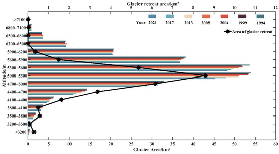
Figure 5.
The area of glacier distribution at different altitudes each year.
The glacier change is closely related to the terrain altitude, as stated in the above analysis and previous studies [73]. However, elevation changes do not directly affect glacier retreat, but climate change at different altitudes can cause glacier change. This would be further analyzed later.
3.2.2. Glacier Shrinkage at Different Slopes
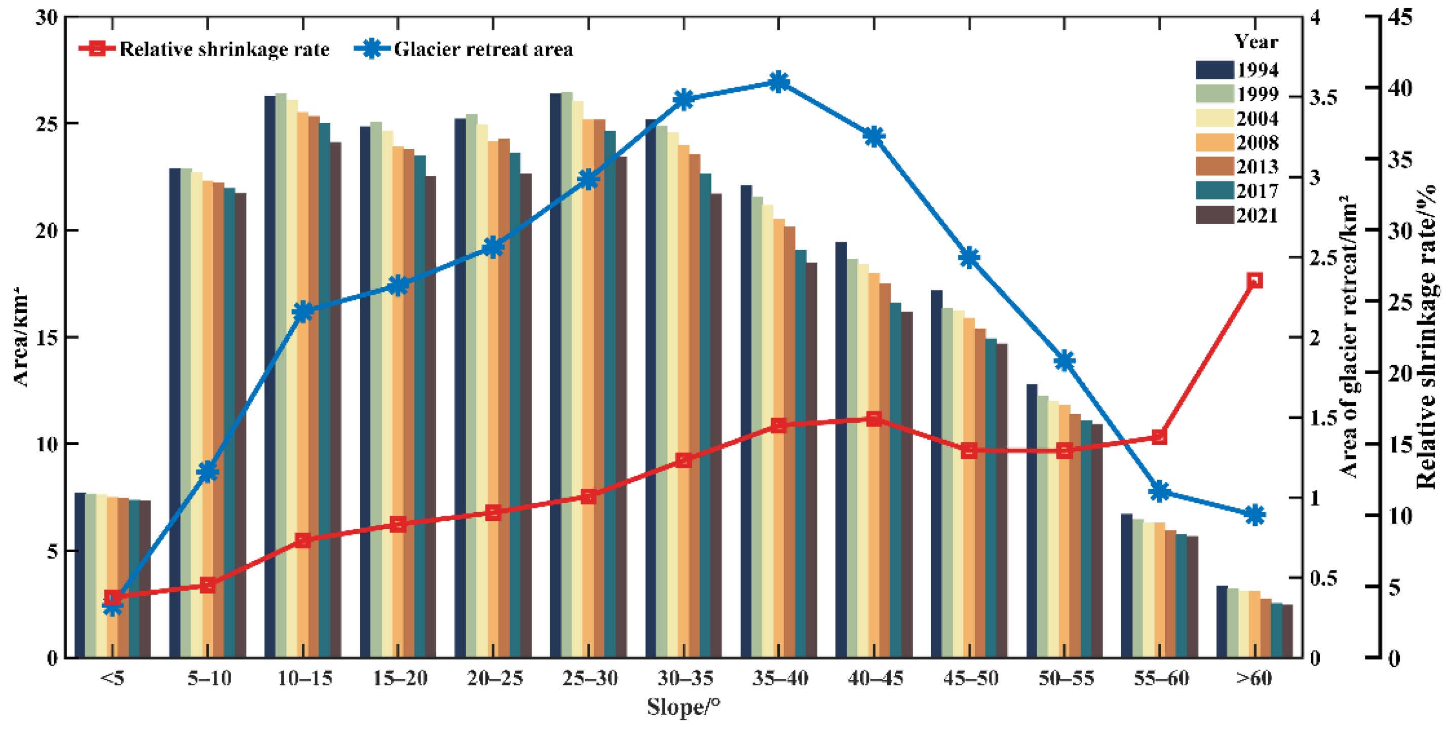
The slope of the Gongga Mountains was divided into 13 classes to analyze the glacier shrinkage (Figure 6). The time series of the glacier retreat area shows an approximately normal distribution. The glacier areas were similar in the regions with slopes of 5°–35°, then showed a decreasing trend in areas with slopes from 35° to 60°. The glacier covers the largest area (24.12 km2) in the range of 10°–15° slope. In 2021, the glaciers were mainly located in the area of slope ranging from 5° to 40°, with an area of 154.61 km2, accounting for 72.96% of the total glacier area.
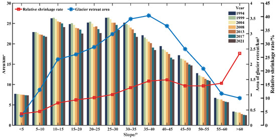
Figure 6.
The glacier shrinkage at different slope gradients in 1994, 1999, 2004, 2008, 2013, 2017, and 2021. The total area of glacier retreat (1994–2021) is shown in the blue line and the relative shrinkage rate is shown in the red line. The relative shrinkage rate (1994–2021) is obtained by the shrinking area divided by the glacier area at the beginning of the period.
From 1994 to 2021, the shrinkage of glaciers showed an increasing trend with an increasing slope, which is consistent with Shi et al. (2021) [35]. The maximum glacier shrinkage (3.59 km2) occurred in areas with a slope of 35°–40°. The minimum shrinkage of glaciers (~0.32 km2) occurred in areas with a slope less than 5°. The highest glacier shrinkage rate occurred in areas with a slope higher than 60°, with a relative shrinkage rate of 26.45%. Large-scale glaciers were mainly composed in areas with slopes less than 50°, while small-scale glaciers mainly distributed in regions with slopes above 50° over the Gongga Mountains [35]. Small glaciers respond more strongly to climate warming than large glaciers. This may lead to a higher glacier shrinkage rate in areas with higher slopes.
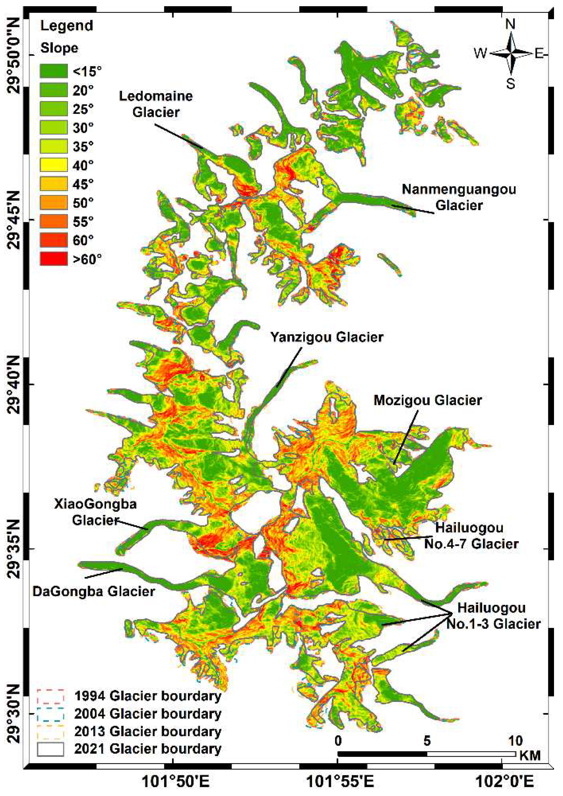
Figure 7 presents the spatial distribution of glacier change in different slope zones. The glacier’s shrinkage is mainly distributed in the area below the 45° slope, with about 21.84 km2 of the glacier having vanished, accounting for 77.67% of the total shrinkage area. The ice tongues of Ledomaine Glacier, Nanmenguangou Glacier, and Yanzigou Glacier in the area with a slope < 40° shrunk most severely between 1994 and 2021. In the south of Dagongba Glacier and Hailuogou Glacier, there is also a significant shrinkage, most of which is located in the slope range of 30°–50°. In the areas with slopes higher than 45°, the glacier shrinkage area is relatively small, with 6.28 km2 from 1994 to 2021, accounting for 22.33% of the total shrinkage area, such as the eastern part of the Xiaogongba Glacier and the southern part of the Nanmengguangou Glacier.
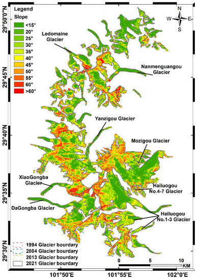
Figure 7.
Glaciers distribution at different slope gradients in 1994, 2004, 2013, and 2021.
3.2.3. Glacier Shrinkage in Different Slope Aspects
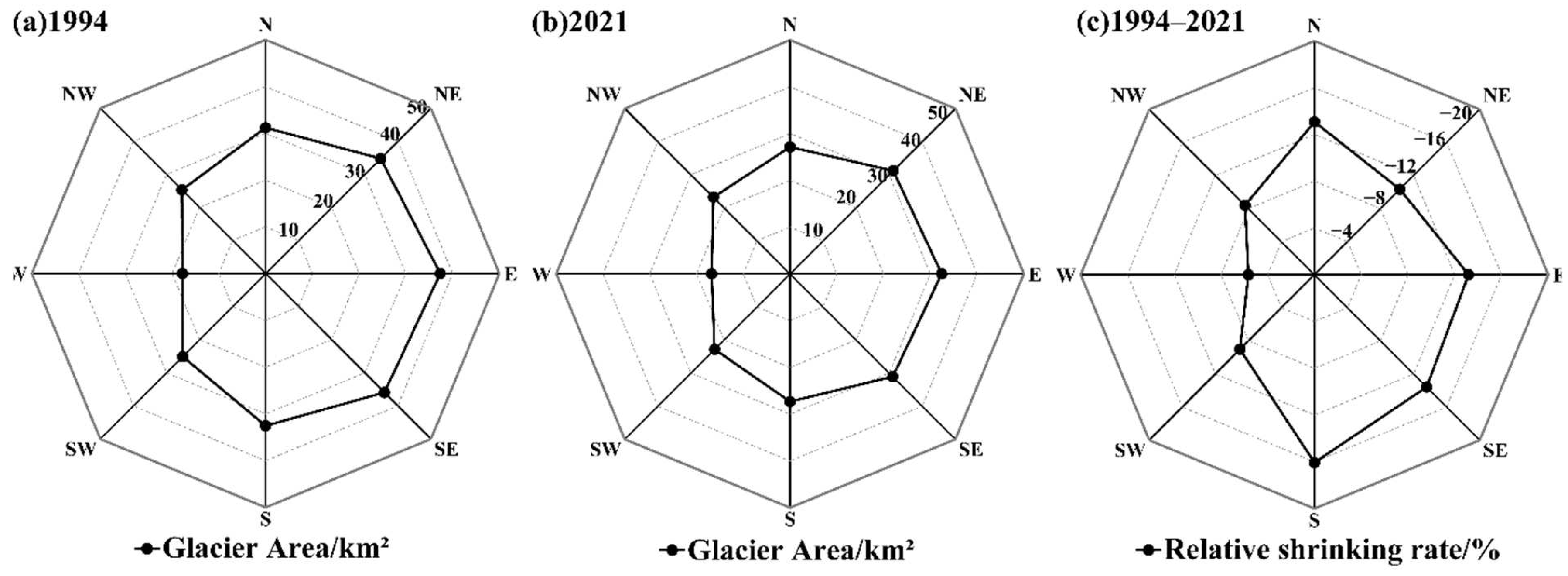
Table 6 shows the glacier area in eight slope aspects, i.e., north (N), northeast (NE), east (E), southeast (SE), south (S), southwest (SW), west (W), and northeast (NW). The glaciers distribute in all aspects over the Gongga Mountain region. The glaciers of the east aspects cover an area of 94.69 km2, accounting for 44.69% of the total glacier area in 2021, whose area is larger than the glacier in the west area (62.78 km2, accounting for 29.63% of the total glacier area) in the same year. This is mainly because the eastern slope area was influenced by the southeast monsoon and received more precipitation than the western slope, thus making the glaciers develop a larger size. In SW, W, and NW aspects, the glacier areas are almost similar from 1994 to 2021. While in other slope aspects (i.e., N, NE, E, SE, and S), the glaciers shrank obviously during 1994–2021. This is mostly because of the increased warming in the eastern area over the Gongga Mountains.

Table 6.
The area of glaciers in different slope aspects (unit: km2).
Figure 8 presents the glacier shrinkage in all slope aspects. The glacier area was exceptionally larger in 1994 (~240 km2, Figure 8a) than that in 2021 (~212 km2, Figure 8b). The glaciers shrank more significantly in the E, SE, and S slope aspects from 1994–2021 (Figure 8c). The largest shrinkage rate (16.05%) is in the south (S) aspect, with a total of 5.22 km2 of glaciers having disappeared, accounting for 18.57% of the total glacier shrinkage area (28.11 km2) from 1994 to 2021. This is consistent with the result of Shi et al. (2021) [35], which also showed the largest shrinkage rate (~29.6%) in the south slope aspect over the Gongga Mountains. This is mainly because of the strong sunshine on the south slope of the Gongga Mountains according to the previous study [35]. The glaciers in the west (W) aspect have the smallest shrinkage area (1.00 km2) accounting for 5.96% of the glacier area in the west slope aspect in 1994.
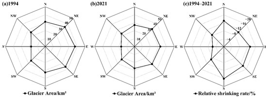
Figure 8.
Glacier shrinkage in all aspects of the Gongga Mountains, including the glacier area in 1994 (a), in 2021 (b), and the glacier shrinking rate from 1994 to 2021 (c).
3.3. Climate Change Impacts on Glacier Shrinkage
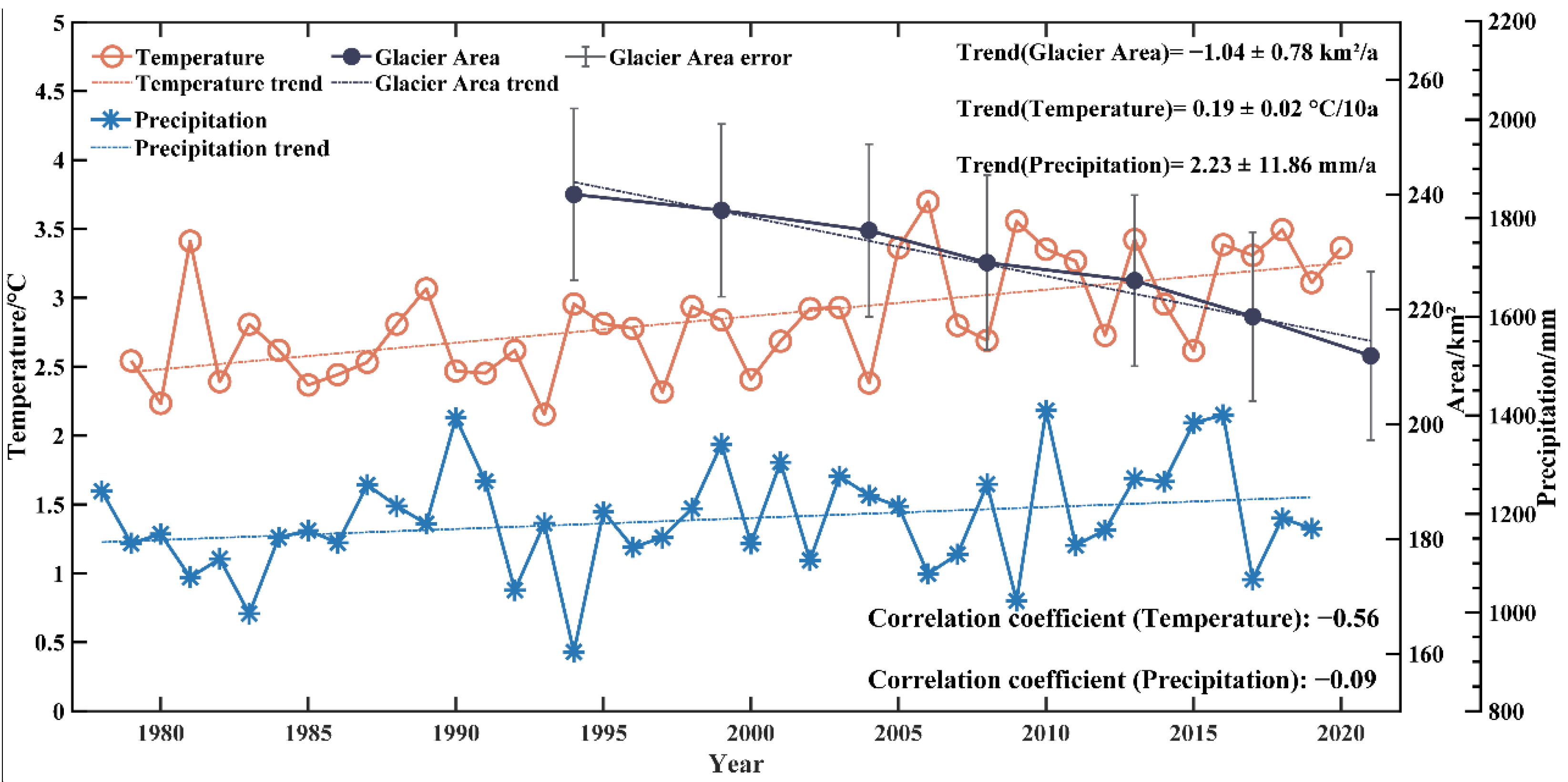
Temperature and precipitation together determine glacier type, development, and evolutionary change [74]. The average summer temperature has a strong influence on glacier melt, while the precipitation throughout the year determines the rate of glacier accumulation [75]. The yearly average summer temperature (from June to September) and the annual precipitation from 1978 to 2020 were calculated (Figure 9). Generally, the average summer temperature increases at a rate of 0.19 ± 0.02 °C/10a (0.02 is the uncertainties derived from the standard deviation of the linear regression as stated in Section 2.3.3, same hereinafter) (F-test, p < 0.05). The annual precipitation presents a weak increasing trend at a rate of 2.23 ± 11.86 mm/a (p < 0.1). The glacier areas of the Gongga Mountains show a remarkable decreasing trend (−1.04 ± 0.78 km2/a, p < 0.05) from 1994 to 2021. The accumulation of the glaciers is much less than the amount of glacier melt, which infers that the glacier shrinkage had a stronger response to the increase in temperature than to the increase in precipitation.
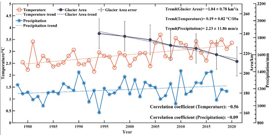
Figure 9.
Changes in temperature and precipitation in the Gongga Mountains region from 1978–2020 and changes in glacier area from 1994–2021. Error bars of the glacier area (gray line) refer to the uncertainties shown in Table 5.
Generally, glaciers have a time lag in responding to climate change [76]. Since small and medium-sized mountain glaciers have a shorter response time to short-term climate fluctuations than large glaciers as previously reported [77], we selected the temperature and precipitation data on the same date as the glacier area changes. The yearly average summer temperature ranges from 2 °C to 4 °C around the Gongga Mountains, reaching a maximum of 3.70 °C in 2006 and a minimum of 2.15 °C in 1993. The annual precipitation is about 1200 mm over the study area, reaching the lowest (920.2 mm) in 1994 and the highest (1410.2 mm) in 2010. The correlation coefficient between the glacier area and the temperature and precipitation are −0.56 (p = 0.25) and −0.09 (p = 0.87), respectively. A stronger correlation and increasing trend illustrate that the temperature plays a dominant role in glacier shrinkage comparing precipitation (increasing trend encouraging glacier accumulation) over the Gongga Mountains.
Braithwaite et al. [78] showed that a 20% increase in the annual precipitation would reduce the negative impact of a 1 °C increase in temperature on glaciers, while a decrease in precipitation would greatly enhance the negative impact of an increase in temperature on glaciers. A more accurate analysis of the relationship between glacier shrinkage and climate change (e.g., temperature and precipitation) requires a longer time series due to the time-lag response. Porter et al. [79] showed that temperate glaciers in low and mid-dimensional regions have a lag time of 10 years or less in response to climate. Pan et al. [31] also showed that the lag time for Hailuogou, Yanzigou, Mozigou, and Dagongba glaciers in the Gongga Mountains region was from 4 to 16 years. The glacier area of the region has been decreasing at a rate of ~1 km2/a (p < 0.05) during 1994 and 2021 (Figure 9). This is mainly influenced by the changes in temperature and precipitation in the early period before 1994. The study of the specific lag time of glacier shrinkage in response to climate change is not the objective of this study, and we will focus on it in future research.
4. Conclusions
The glacier area change and its shrinkage were analyzed under different terrain conditions using Landsat TM/ETM+/OLI imagery, GF-1 imagery, RGI 6.0 data, and ASTER GDEM data. Moreover, the glacier response to climate change in the Gongga Mountains region during 1994–2021 was explored. The results demonstrate that:
(1) The glacier area has a significant decreasing trend (an average annual change of -1.04 ± 0.78 km2/a) during 1994–2021 over the Gongga Mountains region, with the areas being 240.01 ± 14.97 km2 in 1994 but 211.90 ± 14.70 km2 in 2021.
(2) The glaciers on the eastern slopes are better developed than those on the western slopes, with a total area of 94.69 km2, accounting for 44.69% of the total area. The glaciers are mainly located in the area with an altitude ranging from 5000–5300 m and slopes from 5° to 40°. The maximum glacier retreat is in the area with a slope of 35°–40° (a decrease of 3.59 km2), and the minimum retreat is in the slope below 5° (a decrease of 0.32 km2).
(3) The overall summer temperature increases at a rate of 0.19 ± 0.02 °C/10a, while the annual precipitation presented an increasing trend (2.23 ± 11.86 mm/a). The temperature with stronger correlations (CC = −0.56) and increasing trend contributes much more to glacier shrinkage than precipitation does.
This work provides a comprehensive assessment of glacier shrinkage over the Gongga Mountains. It potentially extends our understanding of the various terrain conditions associated with the rapid shrinkage of marine glaciers and the mechanisms of glacier shrinkage responding to climate change. Moreover, this study provides a scientific basis for glacier change research in similar regions across the world, which potentially benefits the research of water resources and natural disaster protection in southeastern Tibet.
Supplementary Materials
The following supporting information can be downloaded at: https://www.mdpi.com/article/10.3390/rs14215397/s1, Figure S1: Comparison of precipitation derived from China Gauge-Based Daily Precipitation Analysis (CGDPA) (blue line) and gauge data (red line) in (a) Luding, (b) Kangding, (c) Shimian, (d) Yajiang, and (e) Jiulong station; Figure S2: Comparison of temperature derived from 1 km monthly mean temperature dataset for China (blue line) and gauge data (red line) in (a) Luding, (b) Kangding, (c) Shimian, (d) Yajiang, and (e) Jiulong station; Figure S3: Comparison of glacier boundaries extracted from Landsat and GF-1 images. (a) Landsat-8 OLI image (OLI432 band compositions, 2021.10.01); (b) band ratio result (band 4 / band 6) from Landsat image; (c) RGI 6.0 data; (d) GF-1 images (321 band compositions, 2021.11.05); (e) band ratio result (band 1 / band 4) from GF-1 image; and (f) the optimized glacier boundary from (b), and corrected by RGI 6.0 data (c); Figure S4: Comparison of Landsat-based glacier boundary in 1994 (first line: (a)-(d)) and 2021 (second line: (e)-(h)). (a) Landsat TM true color image; (b) Landsat TM false-color image (Band5-red, Band4-green, Band3-blue); (c) glacier boundary calculated by band ratio method from Landsat TM; (d) final glacier boundary extraction in 1994; (e) Landsat OLI true color image; (f) Landsat OLI false-color image (Band6-red, Band5-green, Band4-blue); (g) glacier boundary calculated by band ratio method from Landsat OLI; and (h) final glacier boundary extraction in 2021; and Table S1: Statistics of glacier area changes (Landsat and GF-1).
Author Contributions
Z.S. initiated the study and was responsible for the examination of the data and revision of the draft; S.Z. conducted the analysis, wrote the first draft, and revised the draft; Z.S. and S.Z. jointly completed the interpretation of data and plotting; P.S. contributed supervision, discussion, writing-editing, and the final version. All authors have read and agreed to the published version of the manuscript.
Funding
This research was funded by the Natural Science Foundation of Sichuan Province, grant number: 2022NSFSC1031 and was partially funded by the Special Scientific Research Project of the Education Department of Shaanxi Province, grant number: 19JK0837.
Data Availability Statement
Not applicable.
Acknowledgments
We are grateful to the Geospatial Data Cloud, China Resources Satellite Application Center, China Meteorological Center, National Tibetan Plateau Data Center, National Snow and Ice Data Center, and NASA for providing the data required for the study, as well as to the authors of the previous studies for helping our research. Reviewers’ and editors’ comments are also highly appreciated.
Conflicts of Interest
The authors declare no conflict of interest.
References
- Fanyu, Z.; Di, L.; Xingdong, L.; Qi, H.; Pengfei, H. Rapid glacier mass loss in the Southeastern Tibetan Plateau since the year 2000 from satellite observations. Remote Sens. Environ. 2022, 270, 112853. [Google Scholar]
- Hugonnet, R.; McNabb, R.; Berthier, E.; Menounos, B.; Nuth, C.; Girod, L.; Farinotti, D.; Huss, M.; Dussaillant, I.; Brun, F.; et al. Accelerated global glacier mass loss in the early twenty-first century. Nature 2021, 592, 726–731. [Google Scholar] [CrossRef] [PubMed]
- Kulp, S.A.; Strauss, B.H. Author Correction: New elevation data triple estimates of global vulnerability to sea-level rise and coastal flooding. Nat. Commun. 2019, 10, 5752. [Google Scholar] [CrossRef] [PubMed]
- IPCC. IPCC Special Report on the Ocean and Cryosphere in a Changing Climate; IPCC: Paris, France, 2019. [Google Scholar]
- Kaushik, S.; Joshi, P.K.; Singh, T. Development of glacier mapping in Indian Himalaya: A review of approaches. Int. J. Remote Sens. 2019, 40, 6607–6634. [Google Scholar] [CrossRef]
- Burns, P.; Nolin, A. Using atmospherically-corrected Landsat imagery to measure glacier area change in the Cordillera Blanca, Peru from 1987 to 2010. Remote Sens. Environ. 2014, 140, 165–178. [Google Scholar] [CrossRef]
- Pope, A.; Rees, W.G. Impact of spatial, spectral, and radiometric properties of multispectral imagers on glacier surface classification. Remote Sens. Environ. 2014, 141, 1–13. [Google Scholar] [CrossRef]
- Paul, F.; Huggel, C.; Kääb, A. Combining satellite multispectral image data and a digital elevation model for mapping debris-covered glaciers. Remote Sens. Environ. 2004, 89, 510–518. [Google Scholar] [CrossRef]
- Alifu, H.; Vuillaume, J.-F.; Johnson, B.A.; Hirabayashi, Y. Machine-learning classification of debris-covered glaciers using a combination of Sentinel-1/-2 (SAR/optical), Landsat 8 (thermal) and digital elevation data. Geomorphology 2020, 369, 107365. [Google Scholar] [CrossRef]
- Bolch, T.; Menounos, B.; Wheate, R. Landsat-based inventory of glaciers in western Canada, 1985–2005. Remote Sens. Environ. 2010, 114, 127–137. [Google Scholar] [CrossRef]
- Rastner, P.; Bolch, T.; Molg, N.; Machguth, H.; Le Bris, R.; Paul, F. The first complete inventory of the local glaciers and ice caps on Greenland. Cryosphere 2012, 6, 1483–1495. [Google Scholar] [CrossRef]
- Hagg, W.; Mayer, C.; Lambrecht, A.; Kriegel, D.; Azizov, E. Glacier changes in the Big Naryn basin, Central Tian Shan. Glob. Planet. Chang. 2013, 110, 40–50. [Google Scholar] [CrossRef]
- Quincey, D.J.; Richardson, S.D.; Luckman, A.; Lucas, R.M.; Reynolds, J.M.; Hambrey, M.J.; Glasser, N.F. Early recognition of glacial lake hazards in the Himalaya using remote sensing datasets. Glob. Planet. Chang. 2007, 56, 137–152. [Google Scholar] [CrossRef]
- Shukla, A.; Arora, M.K.; Gupta, R.P. Synergistic approach for mapping debris-covered glaciers using optical-thermal remote sensing data with inputs from geomorphometric parameters. Remote Sens. Environ. 2010, 114, 1378–1387. [Google Scholar] [CrossRef]
- Wan, W.; Li, H.; Xie, H.J.; Hong, Y.; Long, D.; Zhao, L.M.; Han, Z.Y.; Cui, Y.K.; Liu, B.J.; Wang, C.G.; et al. A comprehensive data set of lake surface water temperature over the Tibetan Plateau derived from MODIS LST products 2001–2015. Sci. Data 2017, 4, 10. [Google Scholar] [CrossRef]
- Shi, Y.L.; Liu, G.X.; Wang, X.W.; Liu, Q.; Zhang, R.; Jia, H.G. Assessing the Glacier Boundaries in the Qinghai-Tibetan Plateau of China by Multi-Temporal Coherence Estimation with Sentinel-1A InSAR. Remote Sens. 2019, 11, 25. [Google Scholar] [CrossRef]
- Jin, S.; Li, Z.Q.; Wang, Z.M.; Wang, F.T.; Xu, C.H.; Ai, S.T. Ice thickness distribution and volume estimation of Burqin Glacier No. 18 in the Chinese Altay Mountains. J. Arid Land 2020, 12, 905–916. [Google Scholar] [CrossRef]
- Xie, Z.Y.; Haritashya, U.K.; Asari, V.K.; Young, B.W.; Bishop, M.P.; Kargel, J.S. GlacierNet: A Deep-Learning Approach for Debris-Covered Glacier Mapping. IEEE Access 2020, 8, 83495–83510. [Google Scholar] [CrossRef]
- Brenning, A.; Long, S.L.; Fieguth, P. Detecting rock glacier flow structures using Gabor filters and IKONOS imagery. Remote Sens. Environ. 2012, 125, 227–237. [Google Scholar] [CrossRef]
- Chen, L.; Letu, H.; Fan, M.; Shang, H.; Tao, J.; Wu, L.; Zhang, Y.; Yu, C.; Gu, J.; Zhang, N.; et al. An Introduction to the Chinese High-Resolution Earth Observation System: Gaofen-1~7 Civilian Satellites. J. Remote Sens. 2022, 2022, 9769536. [Google Scholar] [CrossRef]
- Zhaoguang, B. Technical features of the Gaofen-1 satellite. Aerosp. China 2013, 8, 5–9. [Google Scholar]
- Fan, X.; Yan, L.; Xu, J.; Hao, X.; Li, H.; Wang, J.; Liu, D. Analysis of glacier change in Manas River basin in the last 50 years based on multi-source data. J. Glaciol. Geocryol. 2015, 37, 1188–1198. [Google Scholar]
- Yang, B.; Zhang, L.; Gao, Y.; Xiang, Y.; Mou, N.; Suolang, D. An integrated method of glacier length extraction based on Gaofen satellite data. J. Glaciol. Geocryol. 2016, 38, 1615–1623. [Google Scholar]
- Yan, L.; Gao, J.; Wang, J.; Hao, X. Glacier mapping based on GF-1 satellite remote sensing. J. Glaciol. Geocryol. 2020, 42, 1400–1406. [Google Scholar]
- Liu, Q.; Zhang, Y. Studies on the Dynamics of Monsoonal Temperate Glaciers in Mt. Gongga: A Review. Mt. Res. 2017, 35, 717–726. [Google Scholar]
- Li, J.J. Hengduan Mountain Glacier; Science Press: Beijing, China, 1996. [Google Scholar]
- Cui, Z.J. A Preliminary Observation of the Modern Glaciers of Gongga Mountain—Commemorating the comrades who died heroically to conquer Gongga Mountain. Acta Geogr. Sin. 1958, 24, 318–342. [Google Scholar]
- Zhen, S.; Orlov, A.B. The Preliminary Report on the Sino-Ussr Joint Glaciological Expedition to Gongga Shan. J. Glaciol. Geocryol. 1991, 13, 181–184. [Google Scholar]
- Xie, Z.; Su, Z.; Shen, Y.; Feng, Q. Mass Balance and Water Exchange of Hailuoguo Glacier in Mount Gongga and Their Influence on Glacial Melt Runoff. J. Glaciol. Geocryol. 2001, 23, 7–15. [Google Scholar]
- Qiao, L.I.U.; Shiyin, L.I.U.; Yong, Z.; Yingsong, Z. Surface Ablation Features and Recent Variation of the Lower Ablation Area of the Hailuogou Glacier, Mt. Gongga. J. Glaciol. Geocryol. 2011, 33, 227–236. [Google Scholar]
- Pan, B.T.; Zhang, G.L.; Wang, J.; Cao, B.; Geng, H.P.; Wang, J.; Zhang, C.; Ji, Y.P. Glacier changes from 1966–2009 in the Gongga Mountains, on the south-eastern margin of the Qinghai-Tibetan Plateau and their climatic forcing. Cryosphere 2012, 6, 1087–1101. [Google Scholar] [CrossRef]
- Zhang, Y.; Liu, S.Y.; Liu, Q. A dataset of glacier mass balance of Hailuogou catchment in Mount Gongga, southeastern Tibetan Plateau, during 1952–2009. China Sci. Data 2018, 3, 7–16. [Google Scholar]
- Cao, B.O.; Pan, B.; Guan, W.; Wen, Z.; Wang, J.I.E. Changes in glacier volume on Mt. Gongga, southeastern Tibetan Plateau, based on the analysis of multi-temporal DEMs from 1966 to 2015. J. Glaciol. 2019, 65, 366–375. [Google Scholar] [CrossRef]
- Xinru, H. Analysis of the Changes in the Surface Elevation and Mass Balance of the Gongga Mountain Glacier in the Past 50 Years Based on Multi-Temporal DEM. Master’s Thesis, Southwest Jiaotong University, Chengdu, China, 2021. [Google Scholar]
- Shi, X.; Dai, K.; Deng, J.; Zhong, D.; Liu, G.; Pirasteh, S.; Zhang, B.; Ali, Y.P.; He, Y.; Liang, R. Extracting the spatio-temporal evolution and geographical features of shrinking Gongga Mountain glacier group during 1989–2017. Adv. Space Res. 2021, 68, 1706–1718. [Google Scholar] [CrossRef]
- Zhou, J.; Zhang, X.; Liu, Z.; Li, Z. Extraction and analysis of mountain glacier movement from GF-1 satellite data. J. Remote Sens. 2021, 25, 530–538. [Google Scholar]
- Pu, J.C. China Glacier Catalog—Yangtze River System; Gansu Culture Press: Lanzhou, China, 1994. [Google Scholar]
- Su, Z.; Liang, D.L.; Hong, M. Developing Conditions, Amounts and Distributions of Glaciers in Gongga Mountains. J. Glaciol. Geocryol. 1993, 15, 551–558. [Google Scholar]
- Yavaşlı, D.D.; Tucker, C.J.; Melocik, K.A. Change in the glacier extent in Turkey during the Landsat Era. Remote Sens. Environ. 2015, 163, 32–41. [Google Scholar] [CrossRef]
- Ke, L.; Ding, X.; Zhang, L.E.I.; Hu, J.U.N.; Shum, C.K.; Lu, Z. Compiling a new glacier inventory for southeastern Qinghai–Tibet Plateau from Landsat and PALSAR data. J. Glaciol. 2016, 62, 579–592. [Google Scholar] [CrossRef]
- Sahu, R.; Gupta, R.D. Spatiotemporal variation in surface velocity in Chandra basin glacier between 1999 and 2017 using Landsat-7 and Landsat-8 imagery. Geocarto Int. 2019, 36, 1591–1611. [Google Scholar] [CrossRef]
- An, G.Y.; Han, L.; Huang, S.C.; Gu, Y.Q.; Zhi, R.R.; Guo, Z.C.; Tong, L.Q. Remote Sensing Survey of Glaciers Based on GF-1 Spectral Data in the Qinghai-Tibet Region. Geoscience 2018, 32, 584–594. [Google Scholar] [CrossRef]
- Zhang, J.; Jia, L.; Menenti, M.; Hu, G. Glacier Facies Mapping Using a Machine-Learning Algorithm: The Parlung Zangbo Basin Case Study. Remote Sens. 2019, 11, 452. [Google Scholar] [CrossRef]
- Frey, H.; Paul, F. On the suitability of the SRTM DEM and ASTER GDEM for the compilation of topographic parameters in glacier inventories. Int. J. Appl. Earth Obs. Geoinf. 2012, 18, 480–490. [Google Scholar] [CrossRef]
- Narama, C.; Kääb, A.; Duishonakunov, M.; Abdrakhmatov, K. Spatial variability of recent glacier area changes in the Tien Shan Mountains, Central Asia, using Corona (~1970), Landsat (~2000), and ALOS (~2007) satellite data. Glob. Planet. Chang. 2010, 71, 42–54. [Google Scholar] [CrossRef]
- Loibl, D.; Lehmkuhl, F.; Grießinger, J. Reconstructing glacier retreat since the Little Ice Age in SE Tibet by glacier mapping and equilibrium line altitude calculation. Geomorphology 2014, 214, 22–39. [Google Scholar] [CrossRef]
- Racoviteanu, A.E.; Arnaud, Y.; Williams, M.W.; Manley, W.F. Spatial patterns in glacier characteristics and area changes from 1962 to 2006 in the Kanchenjunga–Sikkim area, eastern Himalaya. Cryosphere 2015, 9, 505–523. [Google Scholar] [CrossRef]
- Peng, S.Z.; Ding, Y.X.; Liu, W.Z.; Li, Z. 1 km monthly temperature and precipitation dataset for China from 1901 to 2017. Earth Syst. Sci. Data 2019, 11, 1931–1946. [Google Scholar] [CrossRef]
- Shen, Y.; Xiong, A.Y. Validation and comparison of a new gauge-based precipitation analysis over mainland China. Int. J. Climatol. 2016, 36, 252–265. [Google Scholar] [CrossRef]
- Sun, Z.L.; Long, D.; Hong, Z.K.; Hamouda, M.A.; Mohamed, M.M.; Wang, J.H. How China's Fengyun Satellite Precipitation Product Compares with Other Mainstream Satellite Precipitation Products. J. Hydrometeorol. 2022, 23, 785–806. [Google Scholar] [CrossRef]
- Sun, A.Y.; Scanlon, B.R.; Zhang, Z.Z.; Walling, D.; Bhanja, S.N.; Mukherjee, A.; Zhong, Z. Combining Physically Based Modeling and Deep Learning for Fusing GRACE Satellite Data: Can We Learn From Mismatch? Water Resour. Res. 2019, 55, 1179–1195. [Google Scholar] [CrossRef]
- Lu, J.Y. Analysis of the Distribution of Lakes in the Tibetan Plateau Based on Multiple Data Sources. Master’s Thesis, Hunan University of Science and Technology, Xiangtan, China, 2020. [Google Scholar]
- Roy, D.P.; Wulder, M.A.; Loveland, T.R.; Woodcock, C.E.; Allen, R.G.; Anderson, M.C.; Helder, D.; Irons, J.R.; Johnson, D.M.; Kennedy, R.; et al. Landsat-8: Science and product vision for terrestrial global change research. Remote Sens. Environ. 2014, 145, 154–172. [Google Scholar] [CrossRef]
- Matthew, M.W.; Adler-Golden, S.M.; Berk, A.; Richtsmeier, S.C.; Levine, R.Y.; Bernstein, L.S.; Acharya, P.K.; Anderson, G.P.; Felde, G.W.; Hoke, M.L.; et al. Status of Atmospheric Correction Using a MODTRAN4-Based Algorithm; Shen, S.S., Descour, M.R., Eds.; Society of Photo-OpticalInstrumentation Engineers (SPIE): Bellingham, WA, USA, 2000; pp. 199–207. [Google Scholar]
- Li, C.; Jing, Z.; He, X. Remote sensing monitoring of glacier variation in Geladandong, source regions of the Yangtze River from 1986 to 2015. J. Glaciol. Geocryol. 2021, 43, 405–416. [Google Scholar]
- Liu, K.; Wang, N.; Bai, X. Variation of glaciers in the Nubra basin, Karakoram Mountains, revealed by remote sensing images during 1993–2015. J. Glaciol. Geocryol. 2017, 39, 710–719. [Google Scholar]
- Ou, J.; Xu, L.; Pu, T. Glacier change and its response to climate change in the Que'er Mountains,1987–2016. J. Glaciol. Geocryol. 2021, 43, 36–48. [Google Scholar]
- Zhang, W. Research on Glacier Extraction Methods Based on Multi-Source Remote Sensing Data. Master’s Thesis, Lanzhou Jiaotong University, Lanzhou, China, 2016. [Google Scholar]
- Xiao, P.; Feng, X.; Xie, S.; Du, J. Research progresses of high-resolution remote sensing of snow in Manasi River Basin in Tianshan Mountains, Xinjiang Province. J. Nanjing University. Nat. Sci. 2015, 51, 909–920. [Google Scholar]
- Xi, Z.C. Comparative Study on the Extraction Algorithms of Glacier and Lake from the Tibetan Plateau Based on the GF-1 Satellite—A Case Study of the Zangser Kangri. Master’s Thesis, Shandong University of Science and Technology, Qingdao, China, 2018. [Google Scholar]
- Guo, W.; Liu, S.; Xu, J.; Wei, J.; Ding, L. Monitoring Recent Surging of the Yulinchuan Glacier on North Slopes of Muztag Range by Remote Sensing. J. Glaciol. Geocryol. 2012, 34, 765–774. [Google Scholar]
- Bolch, T.; Buchroithner, M.; Pieczonka, T.; Kunert, A. Planimetric and volumetric glacier changes in the Khumbu Himal, Nepal, since 1962 using Corona, Landsat TM and ASTER data. J. Glaciol. 2008, 54, 592–600. [Google Scholar] [CrossRef]
- Liu, S.; Yao, X.; Guo, W.; Xu, J.; Shangguan, D.; Wei, J.; Bao, W.; Wu, L. The contemporary glaciers in China based on the Second Chinese Glacier Inventory. Acta Geogr. Sin. 2015, 70, 3–16. [Google Scholar]
- Zhang, Z.; Liu, S.; Zhang, Y.; Wei, J.; Jiang, Z.; Wu, K. Glacier variations at Aru Co in western Tibet from 1971 to 2016 derived from remote-sensing data. J. Glaciol. 2018, 64, 397–406. [Google Scholar] [CrossRef]
- Beedle, M.J.; Menounos, B.; Wheate, R. Glacier change in the Cariboo Mountains, British Columbia, Canada (1952–2005). Cryosphere 2015, 9, 65–80. [Google Scholar] [CrossRef]
- Chand, P.; Sharma, M.C. Glacier changes in the Ravi basin, North-Western Himalaya (India) during the last four decades (1971–2010/13). Glob. Planet. Chang. 2015, 135, 133–147. [Google Scholar] [CrossRef]
- Pieczonka, T.; Bolch, T. Region-wide glacier mass budgets and area changes for the Central Tien Shan between similar to 1975 and 1999 using Hexagon KH-9 imagery. Glob. Planet. Chang. 2015, 128, 1–13. [Google Scholar] [CrossRef]
- Ye, Q.H.; Zong, J.B.A.; Tian, L.D.; Cogley, J.G.; Song, C.Q.; Guo, W.Q. Glacier changes on the Tibetan Plateau derived from Landsat imagery: Mid-1970s-2000-13. J. Glaciol. 2017, 63, 273–287. [Google Scholar] [CrossRef]
- Wang, Y.T.; Hou, S.G.; Huai, B.J.; An, W.L.; Pang, H.X.; Liu, Y.P. Glacier anomaly over the western Kunlun Mountains, Northwestern Tibetan Plateau, since the 1970s. J. Glaciol. 2018, 64, 624–636. [Google Scholar] [CrossRef]
- Huang, L.; Li, Z.; Zhou, J.M.; Zhang, P. An automatic method for clean glacier and nonseasonal snow area change estimation in High Mountain Asia from 1990 to 2018. Remote Sens. Environ. 2021, 258, 13. [Google Scholar] [CrossRef]
- Cai, X.R.; Li, Z.Q.; Xu, C.H. Glacier wastage and its vulnerability in the Qilian Mountains. J. Geogr. Sci. 2022, 32, 117–140. [Google Scholar] [CrossRef]
- Liao, H.; Liu, Q.; Zhong, Y.; Lu, X. Supraglacial debris-cover change and its spatial heterogeneity in the Mount Gongga, 1990–2019. Acta Geogr. Sin. 2021, 76, 2647–2659. [Google Scholar]
- Pętlicki, M.; Sziło, J.; MacDonell, S.; Vivero, S.; Bialik, R. Recent Deceleration of the Ice Elevation Change of Ecology Glacier (King George Island, Antarctica). Remote Sens. 2017, 9, 520. [Google Scholar] [CrossRef]
- Shi, Y.F. Concise Chinese Glacier Catalogue; Shanghai Science Popularization Press: Shanghai, China, 2005. [Google Scholar]
- Ren, J.W.; Qin, D.H.; Kang, S.C.; Hou, S.G.; Pu, J.C.; Jin, Z.F. Glacier changes and climate warming and drying characteristics in the middle Himalayas. Chin. Sci. Bull. 2003, 23, 2478–2482. [Google Scholar]
- Qin, D.H. Introduction to Climate Change Science; Science Press: Beijing, China, 2018. [Google Scholar]
- Li, J.J.; Su, Z. Glacier in Hengduan Mountains; Science Press: Beijing, China, 1996. [Google Scholar]
- Braithwaite, R.J.; Zhang, Y. Sensitivity of mass balance of five Swiss glaciers to temperature changes assessed by tuning a degree-day model. J. Glaciol. 2000, 46, 7–14. [Google Scholar] [CrossRef]
- Porter, S.C. Pattern and Forcing of Northern Hemisphere Glacier Variations During the Last Millennium. Quat. Res. 1986, 26, 27–48. [Google Scholar] [CrossRef]
Publisher’s Note: MDPI stays neutral with regard to jurisdictional claims in published maps and institutional affiliations. |
© 2022 by the authors. Licensee MDPI, Basel, Switzerland. This article is an open access article distributed under the terms and conditions of the Creative Commons Attribution (CC BY) license (https://creativecommons.org/licenses/by/4.0/).

