Technical Note

Feasibility Analysis of GPS L2C Signals for SSV Receivers on SBAS GEO Satellites

1
Department of Electrical and Computer Engineering, Inha University, Incheon 22212, Korea
2
Korea Aerospace and Research Institute, Daejeon 34133, Korea
*
Author to whom correspondence should be addressed.
Remote Sens. 2022, 14(21), 5329; https://doi.org/10.3390/rs14215329
Submission received: 7 September 2022 / Revised: 20 October 2022 / Accepted: 21 October 2022 / Published: 25 October 2022
(This article belongs to the Special Issue Multi-GNSS: Methods, Challenges, and Applications)

Abstract

:
This paper analyzes the feasibility of Global Positioning System (GPS) L2C signals for use with the space service volume (SSV) receiver on satellite-based augmentation system (SBAS) geostationary orbit (GEO) satellites equipped with L1 and L5 band signal transmitters. Augmentation signals transmitted at L1 and L5 bands from SBAS GEO satellites may interfere with the same bands of SSV GPS-receiving antennas. Therefore, the use of L1 and L5 band signals for the GPS SSV receiver on SBAS GEO satellites is prohibited, and the GPS L2C signal is selected. Unlike ground systems, the various constraints of space exploration in GEO should be considered. Therefore, signal feasibility analysis is essential before considering the use of new global navigation satellite system (GNSS) signals in GEO. This paper presents satellite visibility, dilution of precision, and navigation solution error when the GPS L2C signal is used in GEO satellites through numerical simulation.

1. Introduction

The global navigation satellite system (GNSS) is widely used to obtain continuous navigation solutions in various fields such as ground, maritime, and aviation systems. Over the last few decades, there have been many studies on the use of the GNSS in space missions, which can achieve continuous navigation solutions at a relatively low cost. The National Aeronautics and Space Administration (NASA) of the United States defined an altitude of 3000 km to 36,000 km as the space service volume (SSV) and summarized the characteristics of the Global Positioning System (GPS) signal reception environment according to altitude [1]. With the development of various GNSSs such as GLONASS, Galileo, and the BeiDou System (BDS), several studies have been conducted on how to use multiple GNSSs in the SSV [2,3]. In particular, the International Committee on GNSS Working Group B published a booklet titled “The Interoperable Global Navigation Systems Space Service Volume” [4], where they presented a signal reception performance analysis in various space mission scenarios such as low Earth orbit (LEO), medium Earth orbit (MEO), geostationary orbit (GEO), high Earth orbit (HEO), and lunar missions, in terms of satellite visibility, signal power, geometric dilution of precision (GDOP), etc., when using multiple GNSSs.
Considering only the main lobe of a GNSS signal, LEO satellites can observe more than four satellites most of the time, similar to ground users, such that conventional signal processing schemes can be used, except for the advanced signal acquisition method with a wider Doppler search range. In upper SSVs such as MEO, GEO, HEO, and lunar missions, as shown in Figure 1, since the signal must be received from the opposite side of the Earth, which leads to an area blocked by the Earth’s shadow, most of the main-lobe signals cannot be received, and the signal power is reduced due to the increase in free-space loss. This leads to the use of an effective high-gain antenna at the SSV receiver with an efficient weak signal processing scheme in signal tracking [4].
As a method to improve GNSS performance in the upper SSV, use of the side-lobe signal has been proposed. If the side-lobe signal is used, the signals in the third area shown in Figure 1 can additionally be used. Because additional signals are available, the number of visible satellites and the GDOP performance are improved but with a lower C/N0 in comparison to the main-lobe signal case. It was verified by a flight test that side-lobe signals with a low carrier-to-noise ratio could be tracked in the high-altitude environment of HEO during the AO-40 satellite mission [5]. In the Chang’E 5T mission, China’s HEO mission analyzed on-board GPS measurements in HEO such as visible satellites, position DOP, code measurement errors, and orbit determination results [6]. In addition, the GOES-R mission, a geostationary orbit satellite belonging to NASA, analyzed the signal performance using raw measurement data from the GPS L1 C/A signal [7].
Some simulation results using side-lobe signals have been presented in the literature. The signal feasibility when using the side lobe of multi-constellation GNSS signals over the Korean peninsula was analyzed [8]. The GNSS receiver performance for a new satellite navigation system was analyzed by simulation without considering the interference between the transmission and reception bands [9]. In China, the performance when using the BDS side-lobe signal was analyzed using the precise three-dimensional antenna pattern of the BDS satellite [10].
Numerous studies have analyzed the L1 and L5 band signals commonly transmitted by multiple GNSSs for civilian use with interoperability, as well as for actual missions. However, it was remarked in satellite-based augmentation system (SBAS) GEO satellites, which are equipped with a transmitter broadcasting an augmentation signal at the L1 and L5 bands of the GNSS [11,12,13], that the L1 and L5 band signal transmission antennas may strongly interfere with the GNSS receiver mounted close to the transmitter. Therefore, the use of L1 and L5 band GNSS signals by the SSV receiver on SBAS GEO satellites may be limited. As an alternative, the use of GPS L2C, which is a second civilian signal broadcast in the L2 band, may be considered.
This paper analyzes the feasibility of using GPS L2C signals in SBAS GEO satellites. Before the feasibility analysis, Section 2 analyzes whether SBAS signal transmitters in the L1 band can suppress the interference of receiving antennas in isolation. Section 3 presents the simulation conditions and methods for determining the number of visible satellites, user equivalent range error (UERE), link budget, GDOP, and navigation solution error using real GPS L2C transmitting antenna gain patterns to analyze the feasibility of GPS L2C signals for SBAS GEO satellites. Section 4 provides the corresponding simulation results. Section 5 presents the discussion and conclusions.

2. Assumption of Isolation between GNSS and SBAS signals

Since the SBAS correction signal has a transmit signal power of about 40 W, which is much stronger than the received GNSS signal, with an intensity of approximately −160 dB·W on the ground, isolation is required to suppress the interference from the transmitted signal. The required isolation performance in the L1 band is 202 dB. Table 1 summarizes the required isolation performance and the theoretically calculated isolation performance. Specifically, it consists of 62 dB by transmitting effective isotropic radiated power (EIRP) and 130 dB by receiving signal power compensation, with a 10 dB margin for receiver operation. Isolation of the transmitting and receiving antennas can be divided into isolation by spatial arrangement and isolation by frequency. Transmitting and receiving antennas using the same band can only be used for isolation by spatial arrangement. Isolation by spatial arrangement of the transmitting and receiving antennas using the L1 band signal can be achieved through antenna isolation, antenna directivity isolation, physical shielding, or antenna polarization.
The theoretically expected isolation performance by spatial arrangement is 152.4 dB, which does not satisfy the required isolation performance of 202 dB. Therefore, it is necessary to use a signal of a different band that can be isolated using a bandpass filter. SBAS GEO satellites with the function of transmitting signals in L1 and L5 bands have restrictions on using GNSSs in L1 and L5 bands. Thus, the use of GPS L2C signals broadcasted in another frequency band should be considered.

3. Feasibility Analysis

This section presents the feasibility analysis of the GPS L2C signal in the SSV. The feasibility analysis in this paper was conducted by assessing various figures of merit for GPS SSV receiver performance through simulation, such as satellite visibility, C/N0, GDOP, and navigation error using real GPS L2C transmitting antenna gain patterns. For a comparison according to the receiver performance target, C/N0 thresholds of 18 dB·Hz, 20 dB·Hz, and 23 dB·Hz were used for the analysis. The threshold was selected to 18 dB·Hz by phase and delay lock loop filter thresholds with a little margin [14]. Both 20 and 23 dB·Hz were set for analysis based on the number of available side-lobe signals. For the side-lobe signal, the received signal power intensity is up to 23 dB·Hz, so if the C/N0 threshold is set to 23 dB-Hz, most side-lobe signals will not be available; if the C/N0 threshold set to 20 dB·Hz, it will be able to use a moderate number of side-lobe signals.

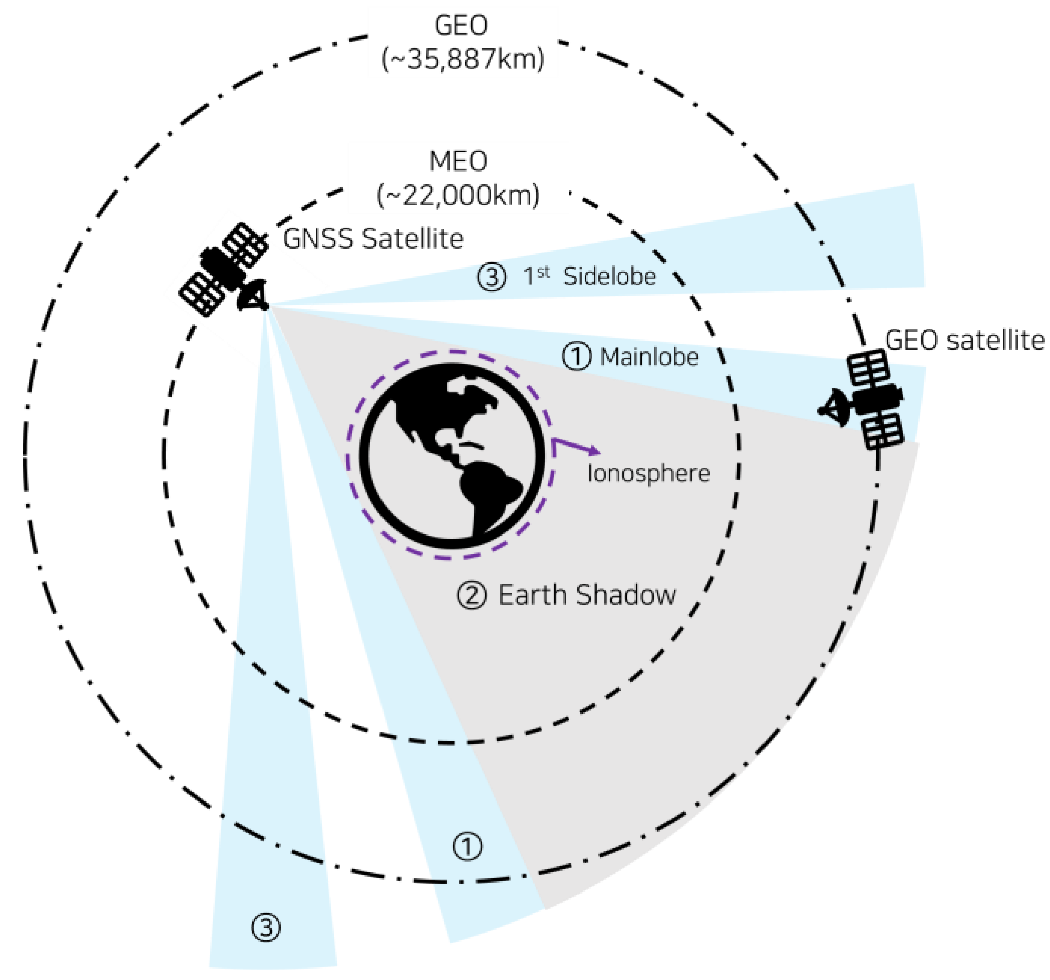
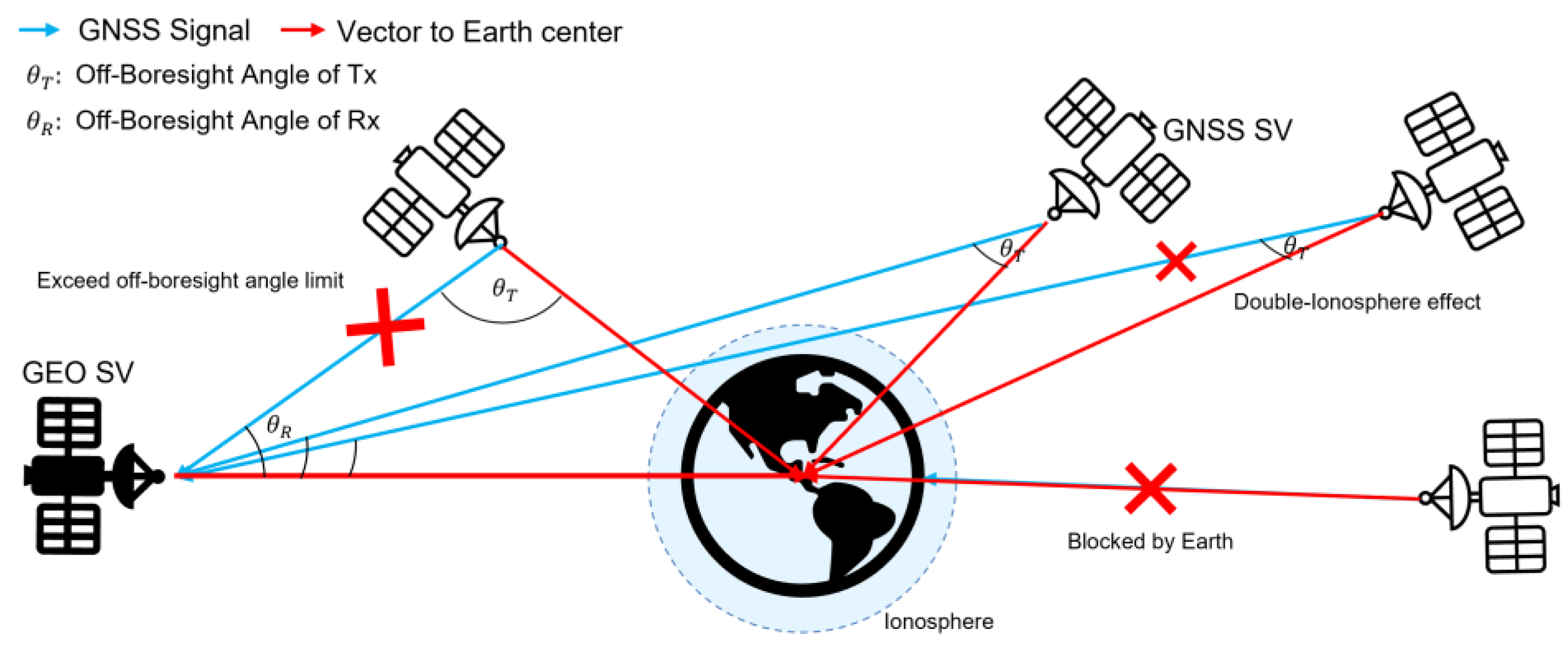
3.1. Satellite Visibility Analysis

Satellite visibility analysis is the process of identifying visible satellites, and the results are derived by analyzing the geometrical arrangement of satellites and the GPS signal power. Visible satellites are GPS satellites that satisfy several conditions. Firstly, the satellites signals should not be obscured by the Earth’s shadow. Secondly, satellites should not exceed the off-boresight angle limit of the transmitting antenna. Thirdly, the calculated received signal power of the satellite should be above the C/N0 threshold.
The geometry of the GPS satellites is calculated through orbital parameters. The simulation in this paper used the Yuma almanac on 25 July 2021 as the orbital parameter of the satellite [15]. Table 2 shows the block type and PRN numbers of satellite operation in July 2021 [16]. Among the 31 GPS satellites in operation, the satellites that broadcast GPS L2C signals were 23 satellites after block IIR-M. In the simulation in this paper, two scenarios were considered: the current scenario, in which 23 satellites broadcast signals, and a future scenario assuming that all block IIR satellites are replaced with GPS III/IIIF satellites, such that all GPS satellites broadcast signals in the full bands.
The GPS L2C signal uses a line-of-sight signal from the GPS satellite to the GEO satellite, and it is assumed that both the transmitting and the receiving antennas face the center of the Earth and are at the center of gravity of each satellite position. The received signal power uses the C/N0 calculated from the link budget as shown in Equations (1)–(3) [17].
P R , d B = P T , d B + G T , d B 20 log 10 R 11 L A , d B   dBW / m 2 ,
P R , d B = A E , d B + P R , d B   dBW ,   where   A E = λ 4 π ,
C / N 0 = P R , d B + G R , d B L R , d B N 0 F R , d B T A   dB · Hz ,
where P R , d B is the received signal’s power spatial density. The received signal power can be obtained by adding the effective area A E , d B to P R , d B . λ is the wavelength of the carrier wave. P T , G T , and L A represent the transmit signal strength, transmitting antenna gain, and atmospheric loss in watts, respectively, and subscript dB represents the logarithmic scale. R represents the distance between the transmitting antenna and the receiving antenna, and 20 log 10 R 11   represents the free-space loss. Figure 2 shows the transmitting antenna gain ( G T ) and the receiving antenna gain ( G R ) for each off-boresight angle. For G T , gain data for each off-boresight angle published by Lockheed Martin were used [18]. For G R , the receiving antenna gain for each off-boresight angle of a high-gain antenna with a maximum gain of 9 dB was used. The off-boresight angle is calculated as the angle between the vector from the GPS satellite to the center of the earth and the vector from the GPS satellite to the GEO satellite, as shown in Figure 3. In addition, according to the GPS interface control document (ICD) [19], the minimum received signal power strength of the GPS III satellite is 1.5 dBW stronger than that of the block IIR-M/IIF satellite. Therefore, to reflect this, the transmit signal strength of the GPS III satellite was set slightly higher. This is summarized in Table 3.

3.2. GDOP and Navigation Error

GDOP is a figure of merit indicating the geometrical distribution of GNSS satellites over the user and affecting navigation accuracy, as shown in Equations (4) to (6).
C o v Δ x Δ b = C o v x ^ b ^ = σ U E R E 2 G T G 1 = σ U E R E 2 H ,
G = x s , 1 x u R 1 y s , 1 y u R 1 z s , 1 z u R 1 1 x s , 2 x u R 2 y s , 2 y u R 2 z s , 2 z u R 2 1 x s , n x u R n y s , n y u R n z s , 1 z u R 1 1 ,
GDOP = H 11 + H 22 + H 33 + H 44 ,
where x = x   y   z is the position in Earth-centered and Earth-fixed coordinates, and b is the clock bias. The covariance matrix of the estimated value is equal to the product of the pseudo-range error component σ U E R E and H, where H can be calculated through the G matrix as shown in Equation (4). The G matrix is a part of the linearized pseudo-range equation. It is an n × 4 matrix calculated from the position of the visible satellite x s , y s , z s , the distance R from the visible satellite, and the position of the GEO satellite x u , y u , z u . The GDOP is expressed as the square root term of the sum of the diagonal components of the H matrix computed through G [14].
In this study, for simplicity, the three-dimensional root-mean-square (RMS) navigation solution error of the GNSS is computed by the covariance propagation rule of least-squares estimation in each time epoch as shown in Equations (7)–(9) assuming zero-mean uncorrelated and non-identically distributed UERE. The UERE can be divided into signals of the space range error that occurs at the GNSS satellite and the user equipment error (UEE) that occurs at the receiver. Therefore, for simplicity, in this paper, σ U E R E is calculated as the DLL thermal noise of the receiver σ t D L L , as shown in Equation (8) [20,21], where c is speed of light in m/s, B n is the DLL noise bandwidth in Hz, and S s f is the power spectral density of the signal, which can be calculated using Equation (9), where B f e is the double-sided front-end bandwidth in Hz, and T c is the chip period.
GNSS   3 D   RMS   position   error   = σ U E R E   GDOP .
σ U E R E = σ t D L L = c B n B f e / 2 B f e / 2 S s f sin 2 π f D T c d f 2 π 2 C / N 0 B f e 2 B f e 2 f S s f sin π f D T c d f 2 × 1 + B f e / 2 B f e / 2 S s f cos 2 π f D T c d f T C / N 0 B f e 2 B f e 2 S s f cos π f D T c d f 2 .
S s f = T c sin c 2 π f T c .

4. Results

Table 4 shows the simulation parameters such as simulation time, user location, receiving antenna, receiver parameters, and ionosphere height. The simulation was performed at GEO over the Korean peninsula for 12 h. The current and future scenarios were described in Section 3.1. The iono-excluded scenario is a scenario in which signals delayed through an area up to 400 km are excluded from visible satellites. The iono-free scenario is a scenario eliminating the influence of the ionosphere on external data. For satellite visibility analysis according to receiver sensitivity, C/N0 thresholds were analyzed at 18, 20, and 23 dB·Hz.

4.1. Satellite Visibility

Figure 4 presents graphs of the number of visible satellites for each scenario, while Table 5 shows the average number of visible satellites and the ratio for the three C/N0 threshold cases when the number of visible satellites was larger than four for point-positioning. The difference in the average number of visible satellites between the iono-excluded scenario and the iono-free scenario with ionosphere correction was about 0.1, which is very small. In addition, since the average number of visible satellites in all future scenarios was four or more, point-positioning would be possible most of the time. In future scenarios, if the C/N0 threshold was less than 20 dB·Hz, point-positioning would always be possible. When the C/N0 threshold was lowered from 23 dB·Hz to 18 dB·Hz, more satellite signals could be received; hence, the average number of visible satellites increased.

4.2. GDOP

Figure 5 GDOP graphs are shown for each scenario, while Table 6 shows the average GDOP and the time ratio of the GDOP < 100(%) which means the ratios of time when the GDOP value is less than 100. When the C/N0 threshold is 18 dB·Hz, the GDOP is always less than 100 and the average GDOP ranges from 6.34 to 11.01. When the C/N0 threshold is 20 dB·Hz or higher, the GDOP exceeds 100 for 6 to 80 % of the 12 hours. The average GDOP ranges from 16.03 to 79.18 which is higher than the 18 dB·Hz case. The iono-excluded scenario has a larger GDOP value and less time ratio of GDOP < 100 than the iono-free scenario because of its poor visibility.

4.3. Navigation Error

The simulated navigation errors for each scenario are shown in Figure 6. Since the navigation error was calculated as the product of GDOP and σ U E R E , there were no values where the number of visible satellites was <4. Table 7 shows a summary of the average values of range error ( σ U E R E ) and navigation error. As the C/N0 threshold was lowered, the range error increased due to the inclusion of many low C/N0 signals in the side-lobe region; however, since the decrease in the GDOP was much larger, the navigation error decreased from approximately 300 m to 85 m. The precision of navigation error results can be improved by many other algorithms such as SPP with Kalman filtering or precise orbit determination [22].

5. Discussion and Conclusions

This paper analyzed the GPS L2C signal feasibility for SBAS GEO satellites equipped with L1 and L5 band signal transmitters; however, L1 and L5 band signals are not available due to interference. Through simulation, 12 h of data were generated at 5 min intervals to calculate satellite visibility, GDOP, UERE, and navigation error. Because the entire GPS constellation does not broadcast the GPS L2C signal, it was assumed that all GPS constellations will broadcast the GPS L2C signal in the future, and we compared this scenario with the current broadcasting conditions. In the case of GEO satellites, and because the GNSS signal must be received from the other side of the Earth, the ionosphere delay occurs twice, and the effect must be eliminated through dual-frequency signal processing. Therefore, a comparison was made assuming that the ionosphere correction was performed using external data, and the signal passing through the ionosphere was excluded. To analyze the effect of receiver sensitivity, three C/N0 threshold cases were analyzed.
In the future scenario, the number of satellites broadcasting the GPS L2C signal was increased by eight; correspondingly, the average number of visible satellites increased by one to three or more. When it was assumed that ionosphere correction was performed using external data, the average number of visible satellites was reduced by about 0.1 less than the case where the signal passing through the ionosphere was excluded. When the C/N0-threshold was 23 dB·Hz, there were more than four visible satellites for about 40 to 80% of the time, the average of the GDOP < 100 was as high as 60 to 70, and the mean estimated navigation error was 85.3 to 132 m. However, when the C/N0 threshold was 18 dB·Hz, and because the number of visible satellites was always four or more in all the scenarios, it was possible to derive the navigation solution through point-positioning using only GPS L2C signals. In that case, the average GDOP was about 6.3 to 11, the mean range error was about 13 m, and the mean estimated navigation error was about 85.3 to132 m. In general, as the range error increased, the navigation error increased; however, since the decrease in the GDOP was larger, the navigation error tended to decrease with the C/N0 threshold.

Author Contributions

Conceptualization, H.-B.L., K.-H.K., and J.-H.W.; methodology, H.-B.L., K.-H.K., and J.-H.W.; software, H.-B.L.; validation, H.-B.L. and J.-H.W.; formal analysis, H.-B.L.; investigation, H.-B.L.; writing—original draft preparation, H.-B.L.; writing—review and editing, J.-H.W.; visualization, H.-B.L.; supervision, J.-H.W.; project administration, J.-H.W. All authors have read and agreed to the published version of the manuscript.

Funding

This research was supported by the “Space Pioneer Program” grant funded by the Ministry of Science and ICT, Republic of Korea, grant number NRF-2021M1A3B9096364.

Conflicts of Interest

The authors declare no conflict of interest.

References

  1. Bauer, F.H.; Moreau, M.C.; Dahle-Melsaether, M.E.; Petrofski, W.P.; Stanton, B.J.; Thomason, S.; Harris, G.A.; Sena, R.P.; Parker, T., III. The GPS space service volume. In Proceedings of the 19th International Technical meeting of the Satellite Division of the Institute of Navigation (ION GNSS 2006), Fort Worth, TX, USA, 26–29 September 2006. [Google Scholar]
  2. Park, Y.; Kwon, K.-H.; Won, J.-H. Performance analysis of multi-constellation and multi-frequency GNSS receivers in deep space. In Proceedings of the 30th International Technical meeting of the Satellite Division of the Institute of Navigation (ION GNSS+ 2017), Portland, OR, USA, 25–29 September 2017; pp. 1127–1132. [Google Scholar]
  3. Enderle, W.; Gini, F.; Boomkamp, H.; Parker, J.J.; Ashman, B.W.; Welch, B.W.; Koch, M.; Sands, O.S. Space user visibility benefits of the multi-GNSS Space Service Volume: An internationally-coordinated, global and mission-specific analysis. In Proceedings of the 31st International Technical Meeting of the Satellite Division of the Institute of Navigation (ION GNSS+ 2018), Miami, FL, USA, 24–28 September 2018; pp. 1191–1207. [Google Scholar]
  4. United Nations. The Interoperable Global Navigation Satellite Systems Space Service Volume; United Nations Office for Outer Space Affairs: Vienna, Austria, 2018. [Google Scholar]
  5. Moreau, M.C.; Davis, E.P.; Carpenter, J.; Russell, K.; David, D.; George, W.; Axelrad, P. Results from the GPS Flight Experiment on the High Earth Orbit AMSAT OSCAR-40 Spacecraft. In Proceedings of the 15th International Technical Meeting of the Satellite Division of The Institute of Navigation (ION GPS 2002), Portland, OR, USA, 24–27 September 2002. [Google Scholar]
  6. Su, X.; Geng, T.; Li, W.; Zhao, Q.; Xie, X. Chang’E-5T orbit determination using onboard GPS observations. Sensors 2017, 17, 1260. [Google Scholar] [CrossRef] [PubMed] [Green Version]
  7. Winkler, S.; Ramsey, G.; Frey, C.; Chapel, J.; Chu, D.; Freesland, D.; Krimchansky, A.; Concha, M. GPS receiver on-orbit performance for the GOES-R spacecraft. In Proceedings of the 10th International ESA Conference on Guidance, Navigation & Control Systems, Salzburg, Austria, 29 May–2 June 2017. [Google Scholar]
  8. Ji, G.-H.; Kwon, K.-H.; Won, J.-H. GNSS signal availability analysis in SSV for geostationary satellites utilizing multi-GNSS with first side lobe signal over the Korean Region. Remote Sens. 2021, 13, 3852. [Google Scholar] [CrossRef]
  9. Ji, G.-H.; Shin, H.; Won, J.-H. Analysis of multi-constellation GNSS receiver performance utilizing 1-st side-lobe signal on the use of SSV for KPS satellites. IET Radar Sonar Navig. 2021, 15, 485–499. [Google Scholar] [CrossRef]
  10. Lin, K.; Zhan, X.; Yang, R.; Shao, F.; Huang, J. BDS Space Service Volume characterizations considering side-lobe signals and 3D antenna pattern. Aerosp. Sci. Technol. 2020, 106, 106071. [Google Scholar] [CrossRef]
  11. Bunce, D. Wide area augmentation system (WAAS) status and history. In Proceedings of the 27th International Technical Meeting of the Satellite Division of the Institute of Navigation (ION GNSS+ 2014), Tampa, FL, USA, 8–12 September 2014. [Google Scholar]
  12. European Union Agency for the Space Programme. Available online: https://www.euspa.europa.eu/european-space/egnos/egnos-system (accessed on 4 May 2022).
  13. GAGAN Redefining Navigation. Available online: https://gagan.aai.aero/gagan/content/gagan-working (accessed on 4 May 2022).
  14. Kaplan, E.D.; Hegarty, C.J. Understanding GPS/GNSS Principles and Applications, 3rd ed.; Artech House: Norwood, MA, USA, 2017; pp. 662–668. [Google Scholar]
  15. CelesTrak, GPS Yuma Almanacs. Available online: https://celestrak.com/GPS/almanac/Yuma/ (accessed on 4 May 2022).
  16. GPS.gov. Available online: https://www.gps.gov/systems/gps/space/ (accessed on 4 May 2022).
  17. Misra, P.; Enge, P. Global Positioning System: Signals, Measurements, and Performance, 2nd ed.; Ganga-Jamuna Press: Lincoln, MA, USA, 2006; ISBN 9780970954411. [Google Scholar]
  18. Marquis, W.A.; Reigh, D.L. The GPS Block IIR and IIR-M Broadcast L-band Antenna Panel: Its Pattern and Performance. Navig. J. Inst. Navig. 2015, 62, 329–347. [Google Scholar] [CrossRef]
  19. Dunn, M.J. NAVSTAR GPS Space Segment/Navigation User Interfaces, IS-GPS-200M; U.S. Space Force: Washington, DC, USA, 2021; pp. 15–17. [Google Scholar]
  20. Betz, J.W.; Kolodziejski, K.R. Generalized theory of GPS code tracking accuracy with an Early-Late discriminator. IEEE Trans. Aerosp. Electron. Syst. 2009, 45, 1538–1564. [Google Scholar] [CrossRef]
  21. Betz, J.W.; Kolodziejski, K.R. Extended theory of Early-Late code tracking for a bandlimited GPS receiver. J. Inst. Navig. 2000, 47, 211–226. [Google Scholar] [CrossRef]
  22. Jiang, K.; Li, M.; Wang, M.; Zhao, Q.; Li, W. TJS-2 geostationary satellite orbit determination using onboard GPS measurements. GPS Solut. 2018, 22, 87. [Google Scholar] [CrossRef]
Figure 1. Signal reception geometry in GEO satellites.
Remotesensing 14 05329 g001
Figure 2. Antenna gain patterns: (a) gain pattern of GPS IIR-M/IIF transmitting antenna [16]; (b) gain pattern of high-gain GNSS receiving antenna.
Remotesensing 14 05329 g002
Figure 3. Satellite visibility analysis.
Remotesensing 14 05329 g003
Figure 4. GPS L2C satellite visibility over 12 h in geostationary orbit for each scenario: (a) C/N0 threshold = 23 dB·Hz; (b) C/N0 threshold = 20 dB·Hz; (c) C/N0 threshold = 18 dB·Hz.
Remotesensing 14 05329 g004
Figure 5. GDOP over 12 h in geostationary orbit for each scenario: (a) C/N0 threshold = 23 dB·Hz; (b) C/N0 threshold = 20 dB·Hz; (c) C/N0 threshold = 18 dB·Hz.
Remotesensing 14 05329 g005
Figure 6. Estimated navigation error over 12 h in geostationary orbit for each scenario: (a) C/N0 threshold = 23 dB·Hz; (b) C/N0 threshold = 20 dB·Hz; (c) C/N0 threshold = 18 dB·Hz.
Remotesensing 14 05329 g006
Table 1. Required isolation performance and theoretical maximum isolation performance in the L1 band.
Required Isolation Performance (dB)
EIRPReceiving
Signal Power
Compensation
MarginTotal
6213010202
Theoretical Maximum Isolation Performance (dB)
Antenna
Isolation
Antenna
Directivity
Isolation
Antenna
Polarization
Physical ShieldingTotal
42.4602030152.4
Table 2. Block type of each GPS satellite [16].
Block TypePRN
IIR2, 13, 16, 19, 20, 21, 22, 28
IIR-M5, 7, 12, 15, 17, 29, 31
IIF1, 3, 6, 8, 9, 10, 24, 25, 26, 27, 30, 32
III4, 14, 18, 23
Table 3. Minimum received power of GPS L2C signal [19].
Block TypeMinimum Received Power
IIR-M/IIF−160.0 dB·W
III−158.5 dB·W
Table 4. Simulation parameters.
ParameterConfiguration
Simulation time12 h, time epoch: 300 s (5 min)
GPS constellationCurrent/future
User positionGEO (over the Korean peninsula, 128 °E, 36,000 km)
Rx antennaHigh-gain antenna (up to 9 dBi)
Ionosphere height400 km (iono-excluded)/0 km (iono-free)
Receiver parametersC/N0 threshold18/20/23 dB·Hz
DLL noise bandwidth ( B n )1 Hz
Frond-end bandwidth ( B f e )4 MHz
Early–late correlator spacing (D)0.1 chips
Coherent integration time (T)20 ms
Code chip width ( T c )1/0.5115 µs
Table 5. Satellite visibility analysis results.
C/N0 Threshold
(dB·Hz)
CurrentFuture
Iono-FreeIono-ExcludedIono-FreeIono-Excluded
Average number of visible SV233.593.514.524.44
205.165.087.477.39
188.228.1511.8311.75
Visible SV > 4 (%)2347.9243.7584.0381.94
2097.9297.92100100
18100100100100
Table 6. GDOP results. Average GDOP is calculated when GDOP is less than 100.
C/N0 Threshold
(dB·Hz)
CurrentFuture
Iono-FreeIono-ExcludedIono-FreeIono-Excluded
Average GDOP2375.8879.1864.5965.85
2036.1936.5216.0316.25
1810.9411.016.346.37
Time ratio of GDOP < 100 (%)2325.0021.5353.4751.39
2085.4284.7293.7593.75
18100100100100
Table 7. Block type of each satellite.
C/N0 Threshold
(dB·Hz)
CurrentFuture
Iono-FreeIono-ExcludedIono-FreeIono-Excluded
Mean range error234.594.664.474.81
207.707.798.828.90
1812.6512.7613.5113.60
Mean navigation error (m)23293.89317.86302.79315.47
20263.97273.39136.33139.44
18130.21132.1685.3586.35
Publisher’s Note: MDPI stays neutral with regard to jurisdictional claims in published maps and institutional affiliations.

