Article

Forest Height Retrieval Based on the Dual PolInSAR Images

1
Iranian Space Research Institute, Tehran 14597-77511, Iran
2
Faculty of Geodesy and Geomatics, K. N. Toosi University of Technology, Tehran 19667-15433, Iran
3
Wood Environment & Infrastructure Solutions, Inc., Ottawa, ON K2E 7L5, Canada
*
Author to whom correspondence should be addressed.
Remote Sens. 2022, 14(18), 4503; https://doi.org/10.3390/rs14184503
Submission received: 8 July 2022 / Revised: 25 August 2022 / Accepted: 30 August 2022 / Published: 9 September 2022
(This article belongs to the Special Issue Polarimetric Remote Sensing)

Abstract

:
A new algorithm for forest height estimation based on dual polarimetric interferometric SAR data is presented in this study. The main objective is to consider the efficiency of the dual-polarization data compared to the full polarimetric images with respect to forest height retrieval. Accordingly, the forest height estimation based on the random volume over the ground model is examined using a geometrical procedure named the three-stage method. An exhaustive search polarization optimization technique is also applied to improve the results by employing the efficiency of all the polarization bases based on the four-dimensional lexicographic PolInSAR vector. The repeat-pass experimental SAR (ESAR) images, which include both L- and P-band full polarimetric data, are employed for the accuracy assessment of the dual PolInSAR data and the newly proposed method for forest height estimation. The experimental results on the L-band PolInSAR data show the ability of the dual PolInSAR data for forest height estimation with an average root mean square error (RMSE) of 4.97 m against Lidar data based on the conventional three-stage method. Additionally, the proposed method results in an accuracy of 2.95 m for forest height estimation, indicating its high potential for tree height retrieval.

1. Introduction

Forest biomass is one of the most important structural parameters of forests that should be accurately determined for environmental and climatic applications. This parameter directly depends on the carbon cycle [1]. However, in general, direct biomass estimation methods do not have an acceptable accuracy. Alternatively, the forest biomass can effectively be measured as the forest height function according to the allometric equation [2,3,4]. However, a reliable estimation of the forest height is still a challenge.
Remote-sensing technology is regarded as a desirable tool for gathering information on forests. This might be due to the vastness of forested areas and the natural barriers of forests [5]. In this regard, the interferometric SAR (InSAR) technique, which can estimate the phase center of a signal in each pixel, has been specially considered as a useful tool for extracting forest parameters [6,7]. However, InSAR measures the phase center in a specific polarization state and is therefore unable to analyze the phase centers in the vertical direction. To resolve this problem, the polarimetric SAR interferometry (PolInSAR) technique is employed. The PolInSAR technique enables the generation of interferograms for arbitrary polarization states that ultimately leads to the differentiation of the phase centers of the vertical structure in a pixel [8]. In fact, the PolInSAR technique has recently been assessed as a powerful technique for structural studies [9,10,11]. In this framework, a forest’s biophysical parameters, such as height, biomass, and crown size, can be derived using the PolInSAR techniques [12,13,14,15].
Thus far, several studies have demonstrated the capability of PolInSAR techniques for the estimation of forest parameters. For instance, Papathanassiou and Cloude [16] examined the application of the single baseline PolInSAR data to measure the volume thickness over a forest area. In their study, a straightforward forest height estimation method was introduced based on the phase difference corresponding to particular polarization bases and the surface- and volume-only polarization basis. However, the proposed method underestimated the forest height due to its assumption about the surface- and volume-only polarization basis [9]. The above-mentioned study also introduced a random volume over ground model, called the RVoG model, as a physical model to interpret the electromagnetic signal over the volume structure on impermeable ground. The RVoG model has been used on many occasions due to the its suitable physical interpretation of the SAR signals in forest areas [15]. Papathanassiou and Cloude also proposed a six-dimensional optimization method to invert the RVoG model [9]. In the proposed method, the volume layer thickness, the average forest extinction coefficient, and the underlying topography phase were estimated from single-baseline fully PolInSAR data based on the complex coherence value in at least three polarization bases. It was reported that the performance of the inversion algorithm depended on the choice of the three selected polarizations, and the results were also sensitive to the initial values of the unknown parameters because of the nonlinear nature of the six-dimensional optimization method. Cloude and Papathanassiou [17] also demonstrated the efficiency of the fully PolInSAR data for the retrieval of forest vertical structures based on the RVoG model by introducing a geometrical method, namely, the three-stage inversion method. Owing to its simplicity and speed, the three-stage method has widely been used for forest height estimation based on the RVoG model [14,18,19]. Multiple studies also developed several improved methods based on the three-stage approach to invert other physical models, such as the random volume over ground with volume temporal decorrelation model, named RVoG + VTD [20]; the varied extinction RVoG model, named the VERVoG model [21]; and the random motion over ground model, named RMoG model [22]. As another example, Managhebi et al. [23] developed a novel geometrical algorithm for forest height estimation based on the repeat pass PolInSAR data, which is affected by temporal decorrelation. The proposed method estimates the volume thickness based on the random volume over ground with a volume temporal decorrelation (RVoG + VTD) model. Furthermore, the use of the three-stage method to estimate the forest height based on the compact interferometric SAR data was considered, which showed the effectiveness of this method for forest height estimation [11].
The majority of forest height estimations using PolInSAR methods are based on the full polarimetric SAR data and comparatively few studies have dealt with dual PolInSAR data. For example, emphasizing the fact that the penetration depth of the X-band strongly depends on the forest density and the dielectric coefficient of the forest mass, Kugler et al. [24] employed dual polarization Tandem-X data to estimate the height of the boreal forest. However, the authors did not address the issue of dual polarization data. The main focus of their study was only on the ability of the X-band data to penetrate the boreal and tropical forests and the signal penetration changes in the forest stands at the beginning of autumn and at the end of winter [24]. Moreover, Fu et al. [25] examined the efficiency of dual polarization data for forest height estimation based on the RVoG model. The higher efficiency that was achieved was due to the advantage of a higher resolution and wider swath-width of the dual pol spaceborne SAR images compared to the quad pol data. In this framework, forest height retrieval was attempted by employing dual PolInSAR images using L-band spaceborne dual PolInSAR data. To this end, the optimal channels were generated to find the maximum coherence amplitude. Then, the RVoG retrieval was performed using a limited number of polarization bases, including HH, HV, and two optimal bases. Thus, the RVoG model can not only be applied to full PolInSAR data, but also to dual PolInSAR data as well. Despite the advantages mentioned in this work, the assumptions made in retrieving the RVoG model based on the three-stage method have not been considered. One of the important assumptions that has a significant effect on the accuracy of the results in solving the RVoG model based on the three-stage method is the assumption of selecting the HV channel as a volume-only channel. Wenxue et al. [5] also employed the dual PolInSAR data to estimate the forest height based on the three-stage method to show the potential of the HH and HV channels for forest height estimation. They have extended the three-stage method by finding the volume-only coherence on the ambiguous line segment based on a least squares method. Overall, the above studies have employed the dual polarization data for the RVoG model retrieval, and the results demonstrated that the use of the dual polarization data was valid. However, the determination of the surface to volume scattering ratio for both observed polarization states, HH and HV, was a challenging task in their proposed methods.
Due to the limited number of studies on forest height estimation using dual SAR data, this study explicitly focuses on the dual PolInSAR. As mentioned earlier, a dual polarization image usually contains a higher spatial resolution and wider swath width compared to full polarimetric data. However, the lack of the polarimetric information compared to the quad pol data is an issue that makes these data less effective for forest height estimation. Thus, the main novelty of this study is its transcendence of the limitations of the dual polarization data for forest height estimation by expanding the number of polarization bases used in the inverting procedure. To this end, the proposed method searches all polarization bases to find the optimum one as the volume-only polarization basis.

2. Materials and Methods

The PolInSAR dataset and the test site are presented in this section. Then, the underlying theory and the proposed method are discussed in detail.

2.1. Study Area and PolInSAR Data

The Remningstorp test site (58°80′N, 13°38′E) is located in Southern Sweden. The Remningstorp test site is overlaid with the forest stand’s boundaries, which cover about 1200 ha of the test site. The topography is relatively flat and varies slightly between 120 and 145 m above mean sea level.
For the performance analysis of the dual PolInSAR data for forest height estimation, the repeat-pass experimental SAR (ESAR) images over the above-mentioned test site were employed. These datasets, which belong to BioSAR 2007 campaign, consist of both L- and P-band full polarimetric data. Additionally, forested parts in the Remningstorp test site have been divided into about 340 forest stands. Large efforts have been made to collect the forest inventory data, including height, stem volume, and forest species at the above-mentioned test site. Additionally, a digital surface model with a spatial resolution of 0.5 m based on helicopter-borne lidar measurements was made available to appraise the results. More recently, several studies have been conducted to estimate the forest parameters based on the C-, L-, and P-band observations from the Remningstorp test site [26]. In this paper, the tests are examined in this study area. Since the main objective of this study is to estimate the forest height, the PolInSAR L-band data was utilized.
In this research, a pair of fully polarimetric airborne L-band datasets with a spatial baseline of 8 m were employed to evaluate the results. These datasets were acquired on 2 May 2007 with spatial resolutions of 0.74 m and 1.5 m in the range and azimuth directions, respectively. The SAR data corresponding to the Pauli basis is shown in Figure 1.

2.2. Random Volume over Ground Model

PolInSAR is a powerful technique used to estimate the physical parameters of the forest area based on the SAR data. However, the experimental results have shown that PolInSAR is not very successful when estimating the biomass directly. To cope with this limitation, a biomass estimation based on the allometric equation, which is defined as a function of the forest height, has been proposed. In this framework, the task of biomass estimation becomes the problem of estimating the forest height. Accordingly, there have been different solutions to more accurately estimate the height based on the PolInSAR data. A particularly efficient and widely used model, which defines the forest as a volume layer with homogeneous particles on a non-penetrable ground, is the random volume over ground model, named the RVoG model [27,28].
The RVoG model uses an exponential structure function to interpret the forest structure as [28]
f ( Z ) = e 2 σ z c o s θ
where f ( Z ) is the structure function, θ is the incidence angle, Z refers to the vertical direction in the volume layer, and σ denotes the mean extinction coefficient, which is usually assumed to be constant along the vertical construction. The RVoG model assumes no ground decorrelation, which leads to a straight line equation for the complex coherence as follows [9]
γ ( w ) = e i φ 0 ( γ v + L ( w ) ( 1 γ v ) )     .       L ( w ) = μ ( w ) 1 + μ ( w )
where γ ( w ) is the complex coherence of the arbitrary polarization basis vector, w , for a selected pixel in the forest area; φ 0 is the phase corresponding to the underlying flat ground; μ ( w ) is defined as the effective ground to volume scattering ratio, which is dependent on the polarization basis and can have any value between 0 for the volume-only polarization basis and 1 for the ground-only polarization basis; and L ( w ) is a real nonnegative polarization-dependent parameter. This parameter can have values between 0 and 1, with limits occurring at one end for pure volume scattering and at the other for pure surface scattering, and γ v represents the volume-only coherence, which is modeled as [9]
γ v = 2 σ c o s θ ( e 2 σ h v c o s θ 1 ) 0 h v e i k z Z e 2 σ Z c o s θ d Z
in which the volume thickness is represented by h v , and k z is the vertical wave number. Nowadays, RVoG is claimed as one of the most popular models for forest height estimation using the PolInSAR technique because of its suitable interpretation of signal interactions in the volume layer. In this framework, several extensions of the basic model were examined to model more parameters, such as temporal decorrelation [17], volume temporal decorrelation [20], and random motion along the forest structure [22]. The basic model includes four unknown parameters in each pixel: mean extinction coefficient, forest height, ground underlying phase, and ground to volume scattering ratio.

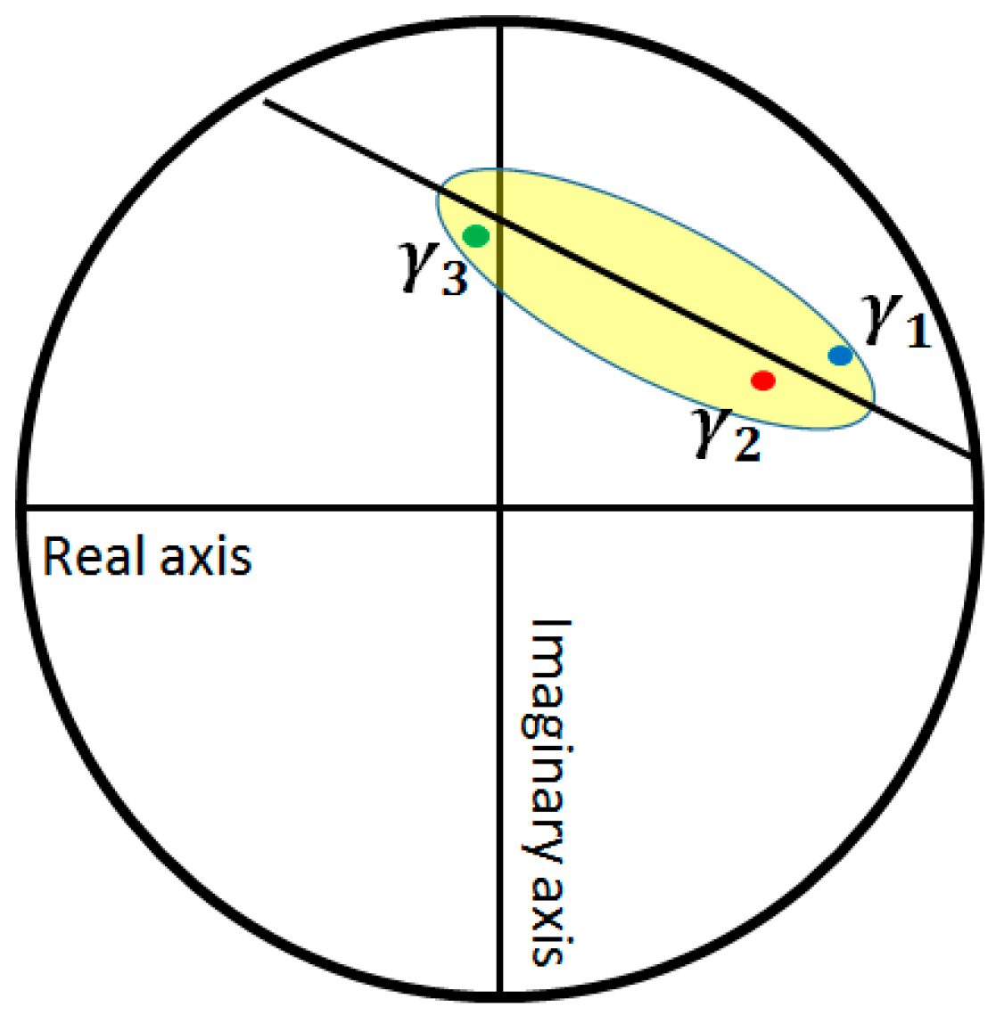
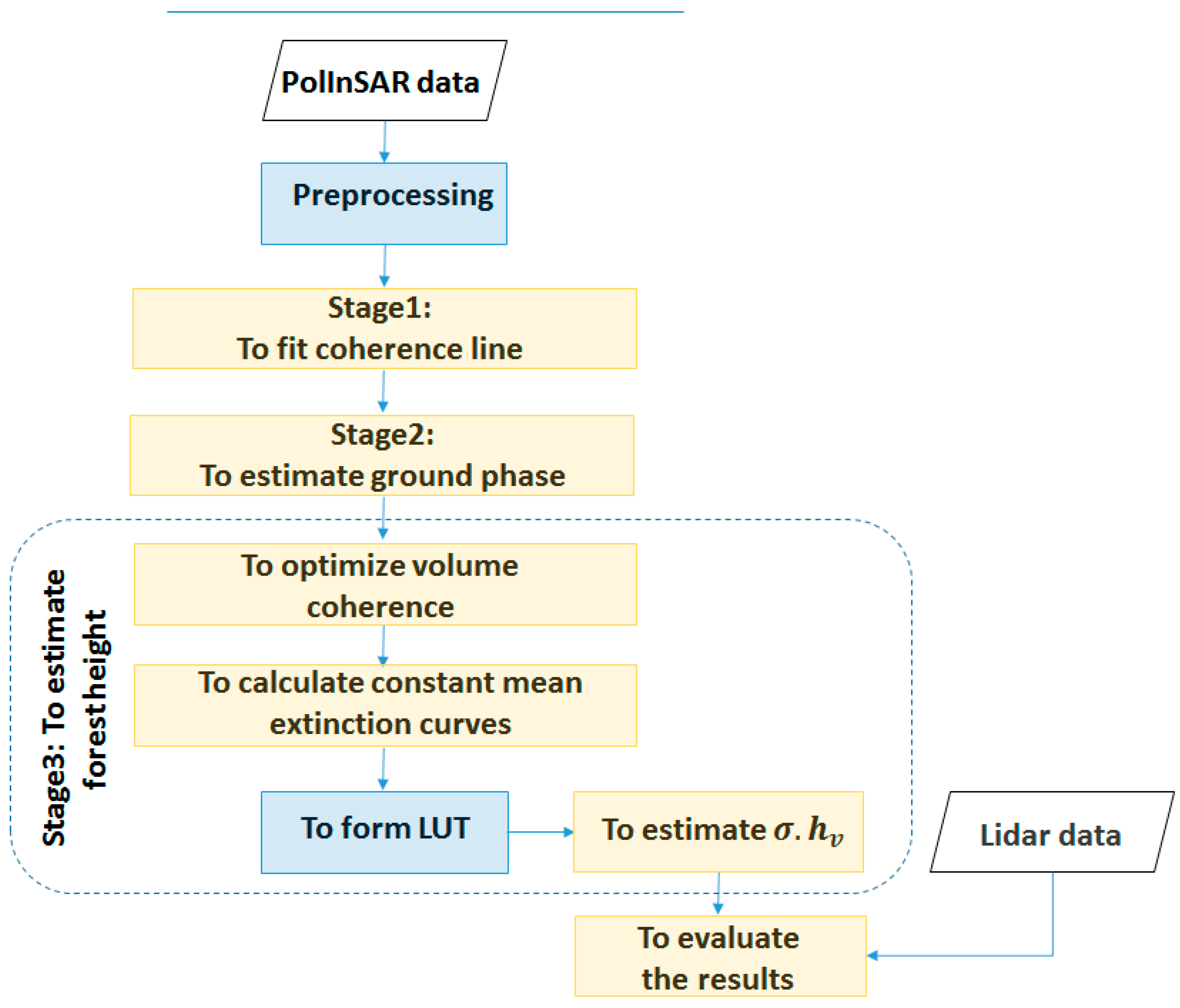
2.3. Three-Stage Method

Owing to the non-linear nature of the RVoG model, the forest height retrieval problem is challenging, and currently, no solid solution is available based on the usual iterative method [9]. In order to overcome the weaknesses of the iterative procedures, such as the initial value selection and long processing time, a simple geometric solution was proposed to invert the RVoG model, called the three-stage method [17]. The widely applied three-stage method decomposes the solution set into three separate steps: finding the coherence line in the complex unit circle (CUC), ground-underlying-phase estimation, and evaluation of the forest height and mean extinction coefficient.
Standard InSAR presents a single complex interferometric coherence for each pixel, whereas Polarimetric SAR interferometry (POLINSAR) provides a polarization-dependent coherence function whose range is called the coherence region [29]. The shape of the coherence region, in the CUC, is formed by changing over the complete set of polarization combinations [8]. Flynn et al. proposed a method for sampling the outer boundary of the coherence region by finding the minimum and maximum eigenvalues and corresponding eigenvectors in an eigenvalue problem as in [29]
T 1 [ Ω H ] w = λ w         { [ Ω H ] = 1 2 ( k 1 k 2 * e i φ + ( k 1 k 2 * ) * e i φ ) T = 1 2 ( k 1 k 1 * + k 2 k 2 * )
where w is the complex unitary projection vector, k 1 and k 2 are the Pauli vectors corresponding to the two polarimetric images,   * denotes the transposed conjugate operator, and φ is the selected phase, which changes between 0 and π . For each pixel, all parameters in Equation (4) are fixed except φ , which changes between 0 and π . In other words, for each change of angle φ in Equation (4), with a specified step (e.g., π 20 ) and in the range from 0 to 180, two points are obtained from the coherence region.
Figure 2 shows a schematic representation of the coherence region for a sample dataset. According to the Equation (2), the coherence region of a pixel in the volume layer is approximated as a straight line. In this framework, the fitting of the coherence line, in the first stage of the three-stage method, is performed using coherence values that are at least in the polarization tripod, as shown in Figure 2. Traditionally, this step is accomplished based on the Pauli vector polarization basis (i.e., γ H H + V V , γ H H V V , and γ H V ).
The ground phase is estimated in the second stage based on the fitted coherence line. As shown in Figure 2, the fitted line intersects the unit circle at two points where the coherence amplitude is maximal. Both intersection points are the ground coherence candidates, and the goal of the second stage is to specify the reliable ground coherence. It is reasonable to assume that the phase centers of the complex coherence corresponding to the surface and double-bounce backscattering mechanisms are close to the ground and the phase center of the cross-polarization basis is close to the top of the canopy. Based on this argument, the intersection point close to the co-polarization basis was selected as the underlying ground coherence in the second stage of the three-stage method—the second intersection point has no physical significance. The last stage focuses on the forest height and the mean extinction coefficient estimations based on Equation (3). The cross-polarization state, HV, is selected as the observed volume-only coherence in the conventional three-stage method.
As mentioned before, the three-stage method utilizes a simple geometrical solution to invert Equation (3) and estimates the forest height without the need for an iterative optimization method. In Figure 3, the colored curves are the calculated volume-only coherence loci based on Equation (3). The mean extinction coefficient is constant in each calculated volume-only coherence curve, and h v changes step by step within the forest height range in the study area. In other words, the volume coherences are calculated by setting two unknown parameters (i.e., h v and σ ) and forming the fixed extinction curves in the CUC. This process continues until the closest calculated volume coherence to the assumed observed volume coherence, γ H V , is found. Eventually, the σ and h v corresponding to the calculated volume-only coherence are the inversion solution couple. Figure 3 demonstrates a schematic representation of the third stage.

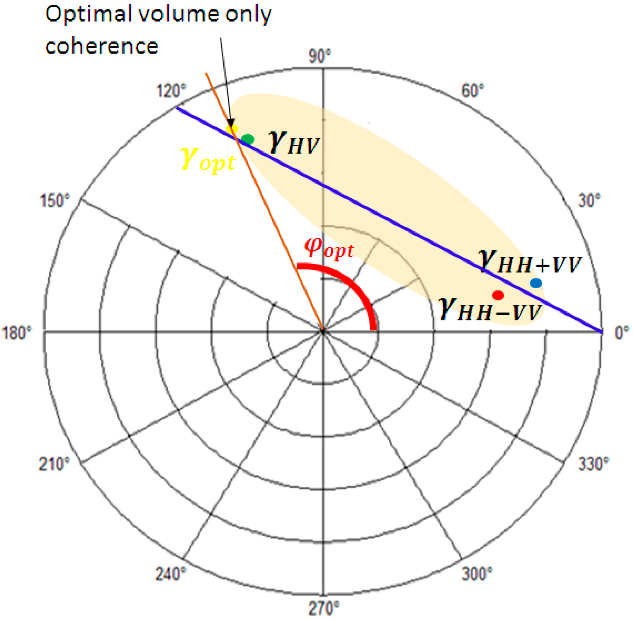
2.4. Optimized Three-Stage Method

The three-stage algorithm estimates the forest height based on Equation (3). In the classical three-stage method, HV is selected as the observed volume-only polarization basis based on the assumption that HV contains no ground-backscattering information. Since the efficiency of the three-stage method is affected by the choice of the observed volume-only coherence, it needs to be addressed. Thus, the main objective of this study is to retrieve the complex volume-only coherence values.
The three-stage inversion method generally overestimates the volume thickness because the phase center of the HV channel is not on the top of the canopy in reality. In order to mitigate this challenge, Managhebi et al. [30] proposed a volume optimization method to estimate the forest height more accurately based on an optimal volume coherence. The proposed method employs an exhaustive search polarization optimization (ESPO) method to find the upper phase center on the coherence line based on the generalization vector expression for the interferometric complex coherence, which is written as [16,31]
γ ( w 1 · w 2 ) = w 1 * k 1 * k 2 w 2 w 1 * k 1 * k 1 w 1 w 2 * k 2 * k 2 w 2 w = [ c o s α s i n α c o s β e i ε s i n α s i n β e i ψ ] T
where w 1 _ and w 2 _ are the complex unitary projection vectors, k 1 and k 2 are the Pauli vectors corresponding to the two polarimetric images, γ ( w 1 · w 2 ) refers to the complex coherence in the selected polarization basis and finally, and   T denotes the transpose operator. According to the parametrization of the w _ ( α , β , ε , ψ ) , all possible complex coherences are calculated and a look-up table is formed based on a simple condition as follows.
φ c a l c > p h a s e ( γ H V )
Finally, the optimal volume-only coherence, φ o p t , is achieved by searching the upper phase center in the LUT. Figure 4 represents the geometrical procedure to find the optimal volume-only coherence.
As represented in Figure 4, the optimal volume coherence is the intersection point of the coherence line and φ = φ o p t . In this framework, the ESPO method characterizes a more reliable observed volume-only coherence to develop the three-stage inversion results.

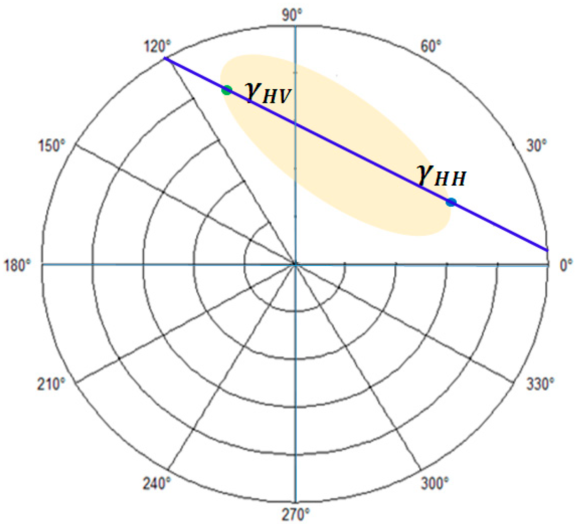
2.5. Forest Height Estimation Based on the Dual PolInSAR Data
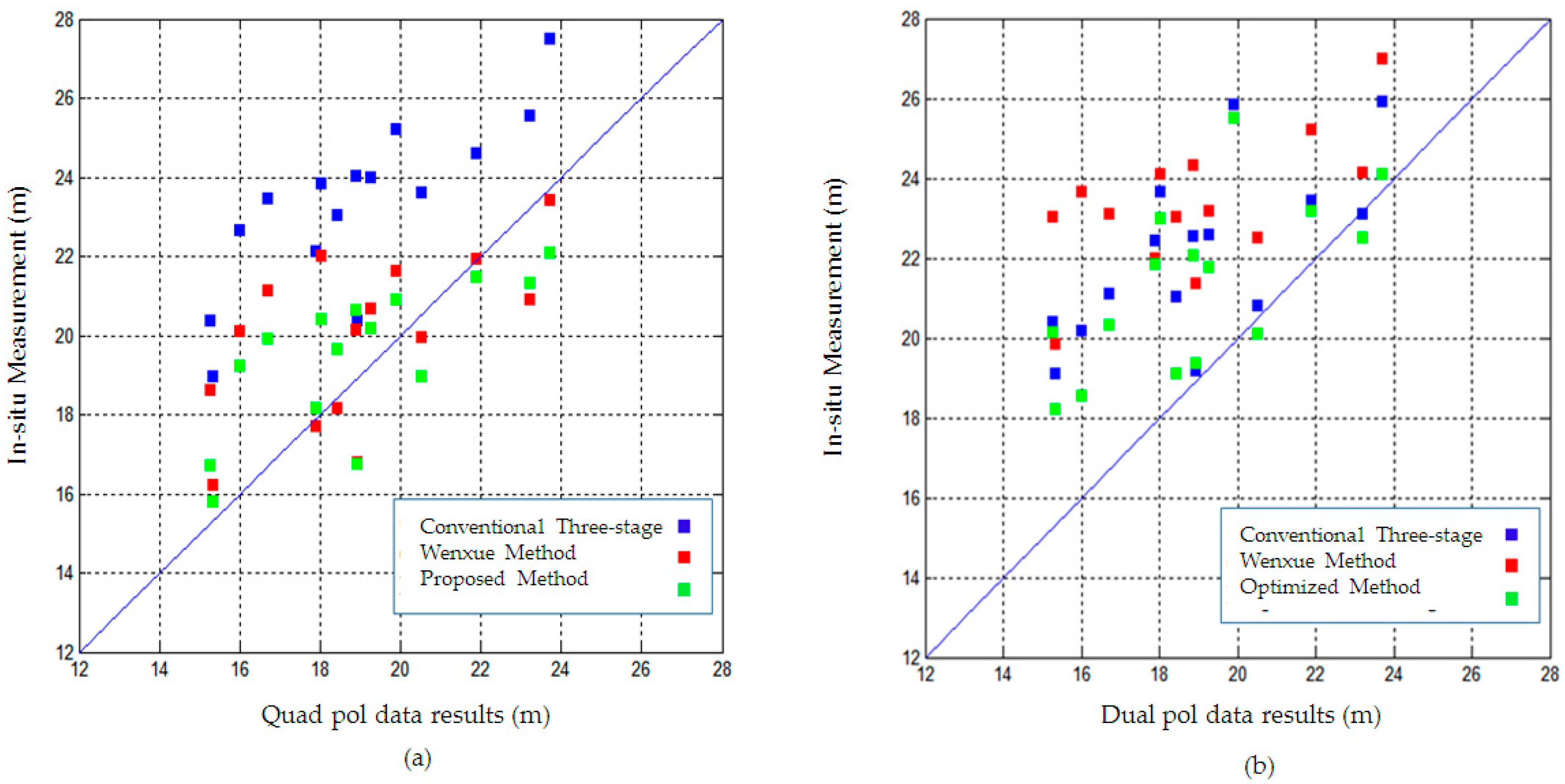
Traditionally, the RVoG retrieval method is applied to the fully polarized data for forest height estimation. However, an optimization method can be used to mitigate the impact of observed polarizations in the dual data and, thus, to improve the results. In this study, the modified three-stage method was exercised for forest height estimation using dual PolInSAR data. It should be noted that the inadequacy of the observed polarization basis in dual data can be compensated if it contains at least both co- and cross-polarization bases in order to have the longest visible line in the CUC. In other words, a combination of HH and VV bases is not a suitable combination for implementing a PolInSAR technique in the forest. Consequently, we used the HH and HV as the co- and cross-polarization bases in this study, respectively.
The dual PolInSAR observation is represented in a four-dimensional cross-Lexicographic PolInSAR vector and, therefore, on the polarimetric interferometry matrix as follows.
L = [ l 1 l 2 ] = [ H H 1 H V 1 H H 2 H V 2 ] T ,   C 4 = L L * = [ C 11 Γ 12 Γ 21 C 22 ]
where superscripts * and   T denote the transpose conjugate and transpose operator, respectively; L is the cross lexicographic vector; C 11 and C 22 are the polarimetric covariance matrices; l 1 and l 2 are the lexicographic vectors; and Γ 12 and Γ 21 are the polarimetric interferometry covariance matrices. In this framework, the boundary of the coherence region can be determined as
C 1 [ C H ] w = λ w         { [ C H ] = 1 2 ( l 1 l 2 * e i φ + ( l 1 l 2 * ) * e i φ ) C = 1 2 ( l 1 l 1 * + l 2 l 2 * )
Based on Equation (8), the coherence region in the dual PolInSAR data is formed as shown in Figure 5.
As expected, the coherence loci in the dual PolInSAR data are more limited because of the inadequate accessible polarization basis compared to the full polarized data. As is clear in Figure 4 and Figure 5, the coherence line; thus, the estimated ground phase based on the dual and quad polarization datasets are also different. However, as illustrated in Figure 3, the coherence curves originate from the estimated ground phase. Thus, the height estimation based on the RVoG model depends on the visible line length, which is a section of the fitted coherence line between ground coherence and volume-only coherence. In this framework, the volume-only coherence selection is one of the most important challenges in the three-stage method. Therefore, the goal of this study is to find a more reliable volume-only coherence based on the dual PolInSAR data; thus, all possible visible polarization bases are searched using the generalization vector expression in dual form. The generalization vector expression for the interferometric complex coherence in the dual form is defined as
γ ( w 1 . w 2 ) = w 1 * Γ 12 w 2 w 1 * C 11 w 1 w 2 * C 22 w 2 w = [ c o s α s i n α e i ψ ] T     .       { 0 α π 2 π ψ π
Equation (9) is the basic equation to employ the exhaustive search polarization optimization method based on the dual PolInSAR data. In this framework, the optimization method employs the polarimetric information to find the optimized volume-only coherence to estimate the forest height more accurately. Figure 6 is the flowchart of the proposed method.
As illustrated in Figure 6, the complex unitary vector should be updated to calculate the new polarization basis. In this regard, the complex unitary projection vector, w _ , is calculated by changing α and ψ based on Equation (9). Afterwards, all observable complex coherences are generated based on Equation (9) by assuming the equal scattering-mechanism scenario ( w 1 = w 2 ). Since the purpose of this search is to achieve the nearest phase center to the top of the canopy, a phase look-up table is formed by isolating the coherence phases more than φ H V as in Equation (6). Finally, the upper phase center in the LUT is selected as φ o p t . In other words, the most reliable observed phase center is the furthest one away from the estimated ground phase in the LUT. Eventually, the optimal observed volume-only coherence is on the coherence line on the one hand, and on the other hand, it is on the φ = φ o p t . In this framework, the optimal volume-only coherence is obtained as the intersection point between the coherence line and φ = φ o p t as illustrated in Figure 7.
Figure 4 and Figure 7 show the volume-only coherence optimization in a particular pixel based on the dual pol and quad pol data, respectively. As expected, the phase center of the optimized volume-only coherence is higher than the phase center of the HV in both datasets. In this framework, the optimized volume coherence, which is the furthest point from the ground coherence on the coherence line, is the most reliable volume-only coherence. Additionally, Figure 4 and Figure 7 depict the performance of the optimization method with respect to increasing the visible line length in the CUC for both dual pol and quad pol data. It is important to note that the ESPO method, though not the quickest, searches all possible polarization bases to find the most dependable volume-only coherence, and that is exactly why we employed this optimization method—on account of its good performance.
Figure 8 illustrates the flowchart of the proposed algorithm for the forest height estimation based on the dual PolInSAR data. In the preprocessing step, the co-registered SAR image pair is used to generate the polarimetric interferometry coherency matrix and the polarimetric interferometry covariance matrix. Subsequently, the flat-earth phase was removed. Finally, the coherency matrix was calculated using a boxcar filter.
As shown in Figure 8, the first two steps of the proposed method are quite similar to the three-stage method, except that here the least squares’ line fitting and the ground phase estimation are performed based on the dual PolInSAR data. As mentioned before, the novelty of the proposed method is in improving the accuracy based on employing an optimization method in the third stage to find the optimum volume-only coherence value. To this end, the third stage is performed based on the optimal volume-only coherence in each pixel, which has been determined according to Figure 7. Based on the proposed optimization method, a pair of α and ψ for each pixel can be obtained, which leads to the best volume polarization basis possessing the higher phase center. In this step, exactly as what was extensively described in Section 2.3 for the conventional three-stage method, the values of h v and σ will be estimated using a geometric method without the need for initial values of the unknown parameters, but this time based on the optimal volume-only coherence.

3. Results

In this study, the L-band ESAR data, which were introduced in Section 2.1, were used in both quad and dual polarization forms to evaluate the efficiency of the dual PolInSAR data compared to the full polarimetric data for forest height estimation. It is worth noting that HH as the co-pol basis and HV as the cross-pol basis were used to allow the dual PolInSAR data formation to have the longest visible line in the complex unit circle. Moreover, all the processing steps were applied to the 15 particular stands. The delineation of the selected forest stands is represented in Figure 1.
First, the flat earth removal was applied to the interferograms. To this end, the polarimetric interferometry coherency matrix and the polarimetric interferometry covariance matrix were generated for each pixel, and a 11 × 11 boxcar filter was applied to reduce the speckle in both matrices’ elements. The processing steps were performed according to the flowchart demonstrated in Figure 8.
The results of this study are compared with the method presented by Wenxue et al. [5] (hereinafter referred to as the Wenxue method) and the conventional three-stage method [17] to evaluate the capabilities of the proposed method (see Table 1). As is clear, the three-stage method estimates that the forest height is 24.6 m based on the quad pol data and 25.7 m based on the dual pol data, whereas the observed height in the selected pixel is 21.6 m. Thus, the estimation error is 3 and 4.1 m for the quad pol and dual pol data, respectively, based on the conventional three-stage method. In fact, the ground component that unavoidably exists in the HV channel causes the error in the forest height estimation. A closer look at Table 1 reveals that the results obtained according to the Wenxue method for the mentioned pixel are the values of 24.4 and 25.3 m for the quad pol and dual pol data, respectively. In fact, the ESPO method represents the best results, i.e., 23.8 and 24.9 m for the quad pol and dual pol data, respectively. Figure 4 and Figure 7 illustrate the efficiency of the proposed method for determining the more reliable volume-only coherence in a pixel for both dual and quad polarization forms. As seen in Figure 7, the estimated ground phase based on the dual PolInSAR data is lower than the estimated ground phase based on the quad PolInSAR data (Figure 4). This is estimate more reliable due to employing the double bounce and surface-scattering polarization bases, HH − VV and HH + VV, in the quad PolInSAR data.
It has been found that branch orientation and size have a critical effect on the volume-only channel backscattering. Branch parameters are in turn strongly dependent on species, so a dependence of species on the backscattering would be expected. For this reason, forest height estimation is generally performed in stands that are as pure as possible in terms of species type [26]. Figure 9 shows the pixel-wise height estimation results by performing the coherence model inversion exclusively from dual PolInSAR data without ground information. It is worth stressing that all the inversion methods were performed on the pixels with a height more than 10 m. As shown in Figure 9, the upper limit of the height range in the conventional three-stage method is higher than the corresponding limit in the Lidar measurement. However, according to Figure 9, the overall pattern in the pixel-wise height map for all three estimation methods is consistent with that obtained from the Lidar measurement.
It is evident that the PolInSAR coherence is influenced not only by the vegetation height but also by the structural or dielectric properties. Therefore, an evaluation of the stands can be performed to properly address solely the height estimation performance. In this framework, all the processing steps were applied to the 15 particular stands that were represented in Figure 1. Figure 10 illustrates the mean estimated forest height in 15 particular stands based on the quad and dual PolInSAR data using the conventional, Wenxue, and proposed three-stage algorithms (horizontal axis) against the Lidar measurement (vertical axis). Based on the results, the conventional three-stage method overestimates the forest height in all 15 stands. However, the overestimation has been modified using both the Wenxue and proposed methods. This improvement is due to the fact that both methods focus on the disadvantage of the conventional three-stage method in selecting the HV channel as the volume-only polarimetric basis.
The root mean square error (RMSE) index was used to evaluate the results and to compare the different methods of height estimation as
R M S E = i = 1 n ( h c a l c h o b s ) 2 n
where n is the is the number of pixels in the desired stand and h o b s and h c a l c are the observed and calculated heights, respectively. Therefore, the Lidar measurement is the reference height, and all the results are compared with these data as the in situ measurement.
The improvement of the forest height estimation using the proposed method is clearly demonstrated in Table 2. As shown in Table 2, the RMSE for all 15 stands decreases more than 2 m using the proposed method in both the quad and dual PolInSAR data. Additionally, the proposed method is more accurate compared to the Wenxue three-stage algorithm. This is mainly because the proposed method investigates all polarization bases to find the most dependable volume-only coherence and since the third stage of the three-stage method is performed based on the optimal volume coherence. However, the Wenxue method calculates the volume-only coherence based on the least-squared method according to Equation (2) and only for two observed polarization bases.
Table 3 presents the number of pixels of each stand and estimated heights’ standard deviation.
As mentioned before, the assessment of the results was performed for the stands to properly address solely the height estimation performance. As shown in Table 3, the standard deviation of the estimated height in the stands is lower than 3.2 m, which is less than RMSE, as shown in Table 2.

4. Discussion

The compilation of polarimetry and interferometry leads to overcoming the limitations of both techniques. This combination is especially valuable in the study of vegetated land cover, where the target is distributed along the vertical direction [8]. In fact, with the PolInSAR technique, we can study a target by generating the interferograms for all the polarization states. Since the phase center changes with the choice of polarization, the vertical information of the targets can be extracted. Therefore, the PolInSAR technique has emerged as a powerful method for volume-related structural studies, e.g., for studying forest area. Furthermore, several retrieval models have been widely used to estimate the volume target parameters using PolInSAR data [9,20,21,22]. In this study, we focused on the RVoG model retrieval, a physical model, which interprets the radar signal along a volume layer above a non-penetrative ground, with the aim of forest height estimation. As detailed in the introduction, most researchers in this field have concentrated on the use of quad PolInSAR data [23,32,33,34] and limited research has been conducted on the use of dual PolInSAR data. The dual polarization data have relatively limited observed polarization states (two polarization states against four polarization states in the full polarimetric data), which caused the more limited coherence region compared to the quad pol data. This drawback has rendered the dual pol data less applicable for forest height estimation. However, this research focused on the dual PolInSAR data’s efficiency for forest height estimation due to their higher spatial resolution and wider swath width in comparison with the full polarimetric images. In this framework, the purpose of this paper was to overcome the limitation of the dual polarization data for forest height estimation by determining a method to expand the number of polarization bases that are used to invert the RVoG model.
The experimental results show the efficiency of the volume optimization method for improving the inversion accuracy. As mentioned in Section 3, the optimization method finds the upper phase center and estimates the unknown parameters based on the optimized volume-only coherence as a more reliable volume coherence. In this study, a new polarization basis was identified between the observed polarization bases. This point was made to emphasize that the new polarization state was not obtained solely on the basis of a geometric process. Thus, the optimized method improves the results of the dual pol data by more than 2 m.
The PolInSAR technique along with the SAR data with different frequencies (e.g., P-band, L-band, and X-band) have extensively been utilized for forest height estimation. In addition, different models such as RMoG, RVoG + TD, RVoG + VTD, and VERVoG can be employed, depending on the forest parameters. In this respect, we suggest investigating the efficiency of the dual PolInSAR data according to other physical models and other optimization methods.

5. Conclusions

The efficiency of the RVoG model and the three-stage inversion algorithm for forest height estimation have previously been argued. Moreover, most studies on forest height estimation have focused on the full polarimetric images with a relatively small coverage. However, although dual polarimetric data have a relatively higher resolution and wider swath width, they have rarely used for forest height estimation. In this respect, the primary purpose of this study was to enhance the dual PolInSAR’s ability for forest height estimation. The formal three-stage method utilizes the HV channel as the volume-only coherence. Thus, the conventional three-stage supposes that the HV has the upper phase center between all polarization bases. A closer look at the results shows that the three-stage method overestimates the forest height due to the inaccurate γ v selection. It should be noted that in the case of a vertical structure combined with temporal decorrelation, the RVoG model overestimates the volume thickness [17,22]. Additionally, the short length of the visible line, which depends on the volume-only coherence selection, has a direct effect on the overestimation of the results [14]. In this regard, using all the polarimetric information to optimize the volume-only coherence selection is the main advantage of the proposed method, which increases the visible line length and, thus, reduces the overestimation error. Based on the results of the proposed method (see Table 2 and Figure 10), we could reduce the overestimation error. Apparently, the ESPO optimization method was used to improve the results according to the volume-only coherence selection in this study. In order to find the optimal volume-only coherence, the ESPO searches all the possible polarizations with a predetermined step and finds the upper phase center by computing the complex coherency in all the polarization bases. In this study, ESPO has been used to find a set of α and ψ for each pixel to calculate an optimal volume-only coherence that has the upper phase center near the top of the canopy. As expected, the proposed method improved the accuracy of the dual pol results by more than two meters.

Author Contributions

Conceptualization, T.M. and Y.M.; methodology, software, T.M.; validation, T.M.; formal analysis, T.M., Y.M. and M.A.; investigation, T.M., Y.M. and M.A.; writing—original draft preparation, T.M.; writing—review & editing, T.M., Y.M. and M.A.; supervision, Y.M. and M.A.; project administration, Y.M. All authors have read and agreed to the published version of the manuscript.

Funding

This research received no external funding.

Acknowledgments

The authors acknowledge the European Space Agency for providing valuable images and field data in the BioSAR 2007 campaign.

Conflicts of Interest

The authors declare no conflict of interest.

References

  1. Le Toan, T.; Quegan, S.; Woodward, I.; Lomas, M.; Delbart, N.; Picard, G. Relating radar remote sensing of biomass to modelling of forest carbon budgets. Clim. Chang. 2004, 67, 379–402. [Google Scholar] [CrossRef]
  2. Blujdea, V.; Pilli, R.; Dutca, I.; Ciuvat, L.; Abrudan, I. Allometric biomass equations for young broadleaved trees in plantations in Romania. For. Ecol. Manag. 2012, 264, 172–184. [Google Scholar] [CrossRef]
  3. Zhou, X.; Yang, M.; Liu, Z.; Li, P.; Xie, B.; Peng, C. Dynamic allometric scaling of tree biomass and size. Nat. Plants 2021, 7, 42–49. [Google Scholar] [CrossRef] [PubMed]
  4. Mette, T.; Papathanassiou, K.; Hajnsek, I.; Pretzsch, H.; Biber, P. Applying a common allometric equation to convert forest height from Pol-InSAR data to forest biomass. In Proceedings of the IGARSS 2004, 2004 IEEE International Geoscience and Remote Sensing Symposium, Anchorage, AK, USA, 20–24 September 2004. [Google Scholar]
  5. Wenxue, F.; Huadong, G.; Xinwu, L.; Bangsen, T.; Zhongchang, S. Extended three-stage polarimetric SAR interferometry algorithm by dual-polarization data. IEEE Trans. Geosci. Remote Sens. 2015, 54, 2792–2802. [Google Scholar] [CrossRef]
  6. Graham, L.C. Synthetic interferometer radar for topographic mapping. Proc. IEEE 1974, 62, 763–768. [Google Scholar] [CrossRef]
  7. Zebker, H.A.; Goldstein, R.M. Topographic mapping from interferometric synthetic aperture radar observations. J. Geophys. Res. Solid Earth 1986, 91, 4993–4999. [Google Scholar] [CrossRef]
  8. Cloude, S.R. Pol-InSAR training course. Radio Sci. 2005. Available online: http://sar.kangwon.ac.kr/polsar/Tutorial/Part2_PolarimetricSARInterferometry/1_Pol-InSAR_Training_Course.pdf (accessed on 7 July 2022).
  9. Papathanassiou, K.P.; Cloude, S.R. Single-baseline polarimetric SAR interferometry. IEEE Trans. Geosci. Remote Sens. 2001, 39, 2352–2363. [Google Scholar] [CrossRef]
  10. Neumann, M.; Ferro-Famil, L.; Reigber, A. Estimation of forest structure, ground, and canopy layer characteristics from multibaseline polarimetric interferometric SAR data. IEEE Trans. Geosci. Remote Sens. 2009, 48, 1086–1104. [Google Scholar] [CrossRef]
  11. Aghabalaei, A.; Ebadi, H.; Maghsoudi, Y. Forest height estimation by means of Compact PolInSAR data. Remote Sens. Appl. Soc. Environ. 2021, 23, 100552. [Google Scholar] [CrossRef]
  12. Neumann, M.; Saatchi, S.S.; Ulander, L.M.; Fransson, J.E. Parametric and non-parametric forest biomass estimation from PolInSAR data. In Proceedings of the 2011 IEEE International Geoscience and Remote Sensing Symposium, Vancouver, BC, Canada, 24–29 July 2011; pp. 420–423. [Google Scholar]
  13. Ni, W.; Sun, G.; Ranson, K.J.; Zhang, Z.; He, Y.; Huang, W.; Guo, Z. Model-based analysis of the influence of forest structures on the scattering phase center at L-band. IEEE Trans. Geosci. Remote Sens. 2013, 52, 3937–3946. [Google Scholar]
  14. Managhebi, T.; Maghsoudi, Y.; Zoej, M.J.V. An improved three-stage inversion algorithm in forest height estimation using single-baseline polarimetric sar interferometry data. IEEE Geosci. Remote Sens. Lett. 2018, 15, 887–891. [Google Scholar] [CrossRef]
  15. Romero-Puig, N.; Lopez-Sanchez, J.M.; Ballester-Berman, J.D. Estimation of RVoG scene parameters by means of PolInSAR with TanDEM-X data: Effect of the double-bounce contribution. IEEE Trans. Geosci. Remote Sens. 2020, 58, 7283–7304. [Google Scholar] [CrossRef]
  16. Cloude, S.R.; Papathanassiou, K.P. Polarimetric SAR interferometry. IEEE Trans. Geosci. Remote Sens. 1998, 36, 1551–1565. [Google Scholar] [CrossRef]
  17. Cloude, S.; Papathanassiou, K. Three-stage inversion process for polarimetric SAR interferometry. IEE Proc.-Radar Sonar Navig. 2003, 150, 125–134. [Google Scholar] [CrossRef]
  18. Xie, Q.; Zhu, J.; Wang, C.; Fu, H.; Lopez-Sanchez, J.M.; Ballester-Berman, J.D. A modified dual-baseline PolInSAR method for forest height estimation. Remote Sens. 2017, 9, 819. [Google Scholar] [CrossRef]
  19. Wu, C.; Wang, C.; Shen, P.; Zhu, J.; Fu, H.; Gao, H. Forest height estimation using PolInSAR optimal normal matrix constraint and cross-iteration method. IEEE Geosci. Remote Sens. Lett. 2019, 16, 1245–1249. [Google Scholar] [CrossRef]
  20. Papathanassiou, K.P.; Cloude, S.R. The effect of temporal decorrelation on the inversion of forest parameters from Pol-InSAR data. In Proceedings of the International Geoscience and Remote Sensing Symposium, Toulouse, France, 21–15 July 2003; Volume 3, pp. 1429–1431. [Google Scholar]
  21. Garestier, F.; Le Toan, T. Forest modeling for height inversion using single-baseline InSAR/Pol-InSAR data. IEEE Trans. Geosci. Remote Sens. 2009, 48, 1528–1539. [Google Scholar] [CrossRef]
  22. Lavalle, M.; Hensley, S. Extraction of structural and dynamic properties of forests from polarimetric-interferometric SAR data affected by temporal decorrelation. IEEE Trans. Geosci. Remote Sens. 2015, 53, 4752–4767. [Google Scholar] [CrossRef]
  23. Managhebi, T.; Maghsoudi, Y.; Valadan Zoej, M.J. Four-Stage Inversion Algorithm for Forest Height Estimation Using Repeat Pass Polarimetric SAR Interferometry Data. Remote Sens. 2018, 10, 1174. [Google Scholar] [CrossRef]
  24. Kugler, F.; Hajnsek, I.; Papathanassiou, K. Dual Pol-InSAR forest height estimation by means of TanDEM-X data. In Proceedings of the IEEE international Geoscience and Remote Sensing Symposium (IGARSS), Munich, Germany, 22–27 July 2012; pp. 1–4. [Google Scholar]
  25. Fu, W.; Guo, H.; Xie, C.; Lu, Y.; Li, X. Forest height inversion using dual-pol polarimetric SAR interferometry. In Proceedings of the 35th International Symposium on Remote Sensing of Environment (ISRSE35), Beijing, China, 22–26 April 2013; IOP Conference Series: Earth and Environmental Science. IOP Publishing: Bristol, UK, 2014; p. 012072. [Google Scholar]
  26. Hajnsek, I.; Scheiber, R.; Lee, S.; Ulander, L.; Gustavsson, A.; Tebaldini, S.; Monte Guarnieri, A. BIOSAR 2007: Technical Assistance for the Development of Airborne SAR and Geophysical Measurements during the BioSAR 2007 Experiment; ESA-ESTEC: Noordwijk, The Netherlands, 2008. [Google Scholar]
  27. Treuhaft, R.N.; Moghaddam, M.; van Zyl, J.J. Vegetation characteristics and underlying topography from interferometric radar. Radio Sci. 1996, 31, 1449–1485. [Google Scholar] [CrossRef]
  28. Treuhaft, R.N.; Siqueira, P.R. Vertical structure of vegetated land surfaces from interferometric and polarimetric radar. Radio Sci. 2000, 35, 141–177. [Google Scholar] [CrossRef] [Green Version]
  29. Flynn, T.; Tabb, M.; Carande, R. Coherence region shape extraction for vegetation parameter estimation in polarimetric SAR interferometry. In Proceedings of the IEEE International Geoscience and Remote Sensing Symposium, Toronto, ON, Canada, 24–28 June 2002; pp. 2596–2598. [Google Scholar]
  30. Managhebi, T.; Maghsoudi, Y.; Zoej, M.J.V. A volume optimization method to improve the three-stage inversion algorithm for forest height estimation using PolInSAR data. IEEE Geosci. Remote Sens. Lett. 2018, 15, 1214–1218. [Google Scholar] [CrossRef]
  31. Cloude, S.R.; Pottier, E. A review of target decomposition theorems in radar polarimetry. IEEE Trans. Geosci. Remote Sens. 1996, 34, 498–518. [Google Scholar] [CrossRef]
  32. Lu, H.; Suo, Z.; Guo, R.; Bao, Z. S-RVoG model for forest parameters inversion over underlying topography. Electron. Lett. 2013, 49, 618–620. [Google Scholar] [CrossRef]
  33. Fu, W.; Guo, H.; Song, P.; Tian, B.; Li, X.; Sun, Z. Combination of PolInSAR and LiDAR techniques for forest height estimation. IEEE Geosci. Remote Sens. Lett. 2017, 14, 1218–1222. [Google Scholar] [CrossRef]
  34. Aghabalaei, A.; Ebadi, H.; Maghsoudi, Y. Forest height estimation based on the RVoG inversion model and the PolInSAR decomposition technique. Int. J. Remote Sens. 2020, 41, 2684–2703. [Google Scholar] [CrossRef]
Figure 1. E-SAR pseudo color image on a Pauli basis (HH + VV, HH − VV, and HV are represented by blue, red, and green, respectively) and the fifteen selected stands that are indicated by colorful polygons (red, yellow, green, light blue, blue, orange, purple, violet, dark green, brown, pink, barberry, navy blue, dark red, and Turquoise).
Remotesensing 14 04503 g001
Figure 2. A schematic representation of the first step of the three-stage method: least-squared line fitting. The yellow region is the practical coherence region and γ 1 , γ 2 , and γ 3 are the selected complex coherence values for the line-fitting step.
Remotesensing 14 04503 g002
Figure 3. A schematic representation of the last step of the three-stage method. The blue line is the coherence line and the complex coherences on the Pauli basis are represented by blue, red, and green circles.
Remotesensing 14 04503 g003
Figure 4. A schematic representation of the improved three-stage method based on the quad pol data. The blue line is the coherence line and the complex coherences on the Pauli basis are represented by blue, red, and green circles. The optimal volume-only coherence is shown by a yellow circle.
Remotesensing 14 04503 g004
Figure 5. The coherence region in the CUC for a dual-polarization pixel.
Remotesensing 14 04503 g005
Figure 6. The flowchart of the volume coherence optimization method in the dual PolInSAR data.
Remotesensing 14 04503 g006
Figure 7. The volume coherence optimization using ESPO method for a dual polarization pixel.
Remotesensing 14 04503 g007
Figure 8. The flowchart of the proposed algorithm for forest height estimation based on the dual PolInSAR data.
Remotesensing 14 04503 g008
Figure 9. The pixel-wise height estimation results obtained by performing RVoG inversion according to the (a) conventional three-stage and (b) Wenxue methods as well as the proposed method based on the (c) dual PolInSAR data and (d) Lidar measurement.
Remotesensing 14 04503 g009
Figure 10. Comparison between LiDAR measurement (vertical axis) and forest height estimation based on the conventional, Wenxue method, and ESPO method (horizontal axis) using (a) quad pol images and (b) dual pol images.
Remotesensing 14 04503 g010
Table 1. The forest height estimation in a randomly selected pixel using different methods applied to dual and quad pol datasets.
In Situ Measurement (m)Dual Pol/Three-Stage (m)Dual Pol/Wenxue Method (m)Dual Pol/Proposed Method (m)Quad Pol/Three-Stage (m)Quad Pol/Wenxue Method (m)Quad Pol/Optimized Method (m)
21.625.725.324.924.624.423.8
Table 2. RMSE in meters of the forest height estimation for the dual and quad PolInSAR data using conventional, Wenxue, and ESPO methods.
Dual Pol/Three-Stage (m)Dual Pol/Wenxue Method (m)Dual Pol/Proposed Three-Stage (m)Quad Pol/Three-Stage (m)Quad Pol/Wenxue Method (m)Quad Pol/Optimized Method (m)
4.973.662.954.482.311.97
Table 3. The number of pixels of each stand and the standard deviations of the estimated forest heights based on the proposed method.
Stand No.Number of PixelsQuad Pol/Standard Deviation of Estimated Height (m)Quad Pol Estimated Height (m)Dual Pol/Standard Deviation of Estimated Height (m)Dual Pol Estimated Height (m)
193872.1215.81.9518.21
218963.1618.163.1921.83
324932.1618.953.0120.09
495891.1816.711.0220.13
559382.0516.731.8119.35
612581.9721.31.8522.51
729281.1419.912.1720.32
833752.0220.392.9122.98
965922.6019.623.1019.11
1013071.5119.211.9818.55
1118,4841.7822.093.1424.11
1224963.0121.461.9223.16
1342371.4520.191.5621.76
1413461.9920.622.7122.04
1542322.3120.883.1925.5
Publisher’s Note: MDPI stays neutral with regard to jurisdictional claims in published maps and institutional affiliations.

