Technical Note

Examining the Role of UAV Lidar Data in Improving Tree Volume Calculation Accuracy

1
Wuyi Mountain National Meteorological Observatory, Wuyishan 354200, China
2
Fujian Institute of Meteorological Sciences, Fuzhou 350008, China
3
Fujian Provincial Key Laboratory for Subtropical Resources and Environment, Fujian Normal University, Fuzhou 350007, China
4
Institute of Geography, Fujian Normal University, Fuzhou 350007, China
5
Baisha State Forest Farm, Shanghang County, Longyan City 364200, China
*
Author to whom correspondence should be addressed.
Remote Sens. 2022, 14(17), 4410; https://doi.org/10.3390/rs14174410
Submission received: 24 July 2022 / Revised: 19 August 2022 / Accepted: 2 September 2022 / Published: 5 September 2022
(This article belongs to the Special Issue UAV Applications for Forest Management: Wood Volume, Biomass, Mapping)

Abstract

:
Traditional forest inventories are based on field surveys of established sample plots, which involve field measurements of individual trees within a sample plot and the selection of proper allometric equations for tree volume calculation. Thus, accurate field measurements and properly selected allometric equations are two crucial factors for providing high-quality tree volumes. One key problem is the difficulty in accurately acquiring tree height data, resulting in high uncertainty in tree volume calculation when the diameter at breast height (DBH) alone is used. This study examined the uncertainty of tree height measurements using different means and the impact of allometric models on tree volume estimation accuracy. Masson pine and eucalyptus plantations in Fujian Province, China, were selected as examples; their tree heights were measured three ways: using an 18-m telescopic pole, UAV Lidar (unmanned aerial vehicle, light detection and ranging) data, and direct measurement of felled trees, with the latest one as a reference. The DBH-based and DBH–height-based allometric equations corresponding to specific tree species were used for the calculations of tree volumes. The results show that (1) tree volumes calculated from the DBH-based models were lower than those from the DBH–height-based models. On average, tree volumes were underestimated by 0.018 m3 and 0.117 m3 for Masson pine and eucalyptus, respectively, while the relative root-mean-squared errors (RMSEr) were 24.04% and 33.90%, respectively, when using the DBH-based model; (2) the tree height extracted from UAV Lidar data was more accurate than that measured using a telescopic pole, because the pole measurement method generally underestimated the tree height, especially when the trees were taller than the length of the pole (18 m in our study); (3) the tree heights measured using different methods greatly impacted the accuracies of tree volumes calculated using the DBH–height model. The telescopic-pole-measured tree heights resulted in a relative error of 9.1–11.8% in tree volume calculations. This research implies that incorporation of UAV Lidar data with DBH field measurements can effectively improve tree volume estimation and could be a new direction for sample plot data collection in the future.

1. Introduction

Forests play important roles in maintaining global carbon cycling and biodiversity. Regular forest inventories at certain time intervals are the main approach to quantifying forest resources and monitoring their dynamics. Generally, forest inventory involves the field measurement of individual trees within preset plots based on sampling theory. The sample plot is a basic unit for providing information on both individual tree levels and forest stand levels [1]. In recent years, remote sensing technology has been widely applied in forest surveys across large areas, and a variety of remotely sensed data including optical, radar, and Lidar with different modeling approaches from simple linear regression to complicated deep learning have been used to estimate forest attributes [2,3,4,5,6]. No matter what remotely sensed data or algorithms are used, sample plot data aggregated from single trees are required for both model development and model validation [7]. By building relationships between remote sensing-derived variables and forest attributes of in situ plots, the continuous distribution of the forest attributes in a study area can be predicted [6,8]. Therefore, accurate measurements of sample plots are crucial for both traditional forest inventories and remote sensing-based modeling approaches.
Forest stock volume is a main element of a forest inventory. The total forest stock volume for a given area is estimated based on the volumes of a large number of representative sample plots, while the forest volume of a sample plot is the sum of the volumes of all individual trees within the plot, expressed as the volume per area unit. The individual-tree volume is calculated using species-specific allometric equations based on tree diameter at breast height (DBH) or the combination of DBH and tree height, which are measured in the field. Thus, the measurement precision of tree parameters and the choice of allometric equations highly affect the data quality of sample plots. Generally, there are two broad categories of allometric equations: single-entry equations with DBH alone as predictor (DBH-based) and double-entry equations with both DBH and tree height as predictors (DBH–height-based).
Current national forest inventories in China uniformly use DBH-based volume tables to calculate tree volumes for easy comparison between consecutive surveys. These DBH-based volume tables are specific to a province or local area and are derived from the standard DBH–height-based volume tables according to the local site conditions and forest growth situations [9,10]. Studies have shown that the accuracy of a stem volume estimated from a DBH–height-based model is generally higher than that from a DBH-based model when only considering the uncertainty caused by the allometric models [11,12]. A comparison of the volume estimates using DBH-based and DBH–height-based models for Masson pine (Pinus massoniana) and Chinese fir (Cunninghamia lanceolata) indicated that the relative errors were between 40% and 60% at tree level [13]. In addition to the estimation accuracy, the variance in volume estimates using a DBH–height-based model is smaller than that using a DBH-based model, indicating a higher stability of volume estimation [14]. However, when tree height is added into an allometric equation, the uncertainty of volume estimates caused by height measurements is much higher than that caused by DBH alone. There have been reports showing more accurate volume estimates using a DBH-based model than using a DBH–height-based model due to the high uncertainty in height measurements [15]. This is due to the fact that measuring DBH is much easier and more precise than measuring tree height in the field. Therefore, obtaining accurate tree height is crucial when using a DBH–height-based model to calculate tree volume. However, it is not easy to measure the heights of standing trees accurately in forests, especially in mountainous regions.
Common methods to used measure tree heights involve the use of instruments such as telescopic poles, laser altimeters, clinometers, and hypsometers [16], among which the telescopic pole is the easiest to operate just by lifting the top of a pole to the same level as the top of the tree. This method is suitable for small trees because of the limited pole length (18 m in our study). When the tree height is higher than the pole length, the tree height measurement may have large errors. Moreover, it is hard to judge whether the top of a pole is at the same level as the top of a tree in dense forests. Another common method is to use a laser altimeter, which is based on the triangulation relationship between the distances from the altimeter to the tree base and treetop [17]. However, using a laser altimeter is also a challenge in a forest site due to the complex and dense canopy structures, especially in sites with steep slopes in mountainous regions.
Lidar techniques, particularly airborne Lidar, with their powerful capability of capturing accurate 3-dimensional (3D) information of ground features, are proven to be important means for providing accurate vertical forest structures, and are widely used to assist traditional in-situ forest inventories [18,19] or to estimate various forest structure parameters, including tree height [17], canopy height [20], canopy density [20,21], species diversity [22], above-ground biomass [23], and stock volume [6]. Unmanned aerial vehicles (UAVs), as an alternative remote sensing platform, have advantages over manned aircrafts or satellites in real-time applications, such as easy operation and low costs [24]. UAVs equipped with precise GPS fly at remarkably low altitudes, offer very high-spatial resolution optical images or high-density Lidar point clouds, from which different tree attributes are retrieved accurately [25,26]. In particular, UAV Lidar with a high point density can accurately depict the 3-D structure of individual trees and has been regarded as an important data source for extracting tree height in recent years [27,28]. For instance, Dalla Corte et al. [27] analyzed the correlation between direct tree height measurements and Lidar-derived tree heights at the individual tree level, and obtained a correlation coefficient of 0.91 and a relative root mean square error of 7.9%; Cunha Neto et al. [29] examined the impact of Lidar point densities on height extraction accuracies of Araucaria angustifolia trees in an urban Atlantic rain forest, and found no significant differences when the point density was greater than 25 point/m2. Those studies demonstrated the potential of UAV Lidar systems for measuring forest plantations, reducing field workloads, and providing an important tool to assist in decision making for forest management.
The importance of incorporating tree height with DBH for tree volume calculation is recognized, but rarely has research examined the uncertainty between using or not using tree height in the allometric equations for calculating volume. Therefore, this research aimed to (1) improve the understanding of using UAV Lidar in extracting tree height through comparative analysis with tree height measurements using a telescopic pole and direct measurement of felled trees; (2) understand the effects of using accurate tree height measurements on tree volume calculations; (3) understand the necessity of using DBH–height-based allometric equations by comparing them with DBH-based ones in providing high-quality tree volume data.

2. Materials and Methods

2.1. Study Area

Two experimental sites—Yuanling Forest Farm in Yunxiao County and Baisha Forest Farm in Shanghang County, Fujian Province, China (Figure 1)—were selected. This region has a subtropical monsoon climate with an average annual temperature of 19–21 °C and average annual precipitation of 1730 mm. These two sites have undulating terrains with elevations between 34 and 730 m and slopes between 15 and 50 degrees. Eucalyptus is the dominant tree species in the Yuanling Forest Farm, and Masson pine and Chinese fir are the dominant tree species in the Baisha Forest Farm.

2.2. Field Measurements of Individual Trees

Field surveys were conducted in July and August 2021. One eucalyptus plot and one Manson pine plot measuring 20 m × 20 m each were set up. The geographic coordinates of each corner of the plots were precisely located using real-time kinematic (RTK) global positioning system (GPS). Topographic characteristics such as elevation, slope, and aspect were also described. The DBH of each tree within a plot was measured using a diameter tape, while the heights of the selected trees were measured using an 18-m telescopic pole before cutdown. For trees taller than 18 m, the portions above 18 m were estimated visually. The location of each tree was recorded using RTK GPS; the sketch of tree positions relative to one another was drawn in the field, and the precise tree spatial distribution map, based on the RTK records, was created later in the laboratory. After trees were felled, the heights of all felled trees (used as reference data) were measured again using an adequately long tape. Table 1 presents counts of all trees within plots, number of trees measured using the telescopic pole, and numbers of felled trees, as well as the ranges of DBH and height of the felled trees for each species.

2.3. Collection of UAV Lidar Data and Extraction of Individual Tree Heights

UAV Lidar data were acquired in July and August 2021. The RT470 multirotor UAV carrying the R1350 Lidar system flew at a height of 150 m over predesignated areas in Yuanling and Baisha Forest Farms. Point clouds with a density of 40–80 pts/m2 covering a total area of about 18 km2 were obtained for these sites (Figure 1). The major process of the UAV Lidar point clouds included filtering, denoising, normalizing, and generating canopy-height model (CHM) data [30]. The data providers classified Lidar point clouds into ground and nonground points by a filtering process. Denoising included removal of low points, air noise, and isolated points. Meanwhile, we manually identified power lines and deleted them from the Lidar data. Based on ground and nonground points, DEMs (digital elevation models) and DSMs (digital surface models) at different pixel sizes (0.3–1.0 m) were generated using inverse-distance-weighted interpolation, and the CHMs were obtained by subtracting DEM from DSM.
In order to extract individual tree heights from Lidar data, one critical step was to generate a single-tree crown image through a proper segmentation approach. Commonly, there are two approaches used for single-tree segmentation based on point clouds and in Lidar-derived CHM [31,32,33,34]. The CHM-based method is to identify single trees through a pixel growth algorithm; it is fast and efficient. However, during the process of generating CHM, some information is lost, leading to missing trees beneath the canopy [35]. The segmentation based on Lidar point cloud data adopts a local-maximum method and produces a tree crown based on seed points, avoiding the loss of data. Corresponding to the segmentation methods for individual trees, there are two ways to extract individual tree height: the maximum CHM data within each segment or the maximum point clouds within the same tree crown [36]. Of the various segmentation algorithms, such as marker-controlled watershed, mean-shift clustering, graph-cut segmentation, and the tree-crown boundary-transformation method based on fishing net dragging, the marker-controlled watershed method based on CHM has been widely used in single-tree crown segmentation [37,38,39]. Thus, we also used it in this research. In addition, different cell sizes were tested, and an optimal resolution of 0.4 m was identified for CHM segmentation. The maximum value of the CHM within a segmented tree crown was taken as the height of that tree. For the understory trees, the crowns of which could not be detected by tree segmentation, treetop positions were determined by visually examining the normalized Lidar point clouds from different views around the tree locations recorded by RTK on the tree distribution map. Once the treetop positions were identified, the tree heights were determined, which were equal to the values of normalized Lidar points at the treetop positions.

2.4. Evaluation of Tree Height Measurement Results

The felled-tree height measurements were used as reference data, and the tree height values obtained using a telescopic pole and UAV Lidar were evaluated through comparative analysis of the assessment factors—Pearson correlation coefficient (r), bias (bias), relative deviation (bias%), root mean square error (RMSE), and relative root mean square error (RMSEr) [16]. For this purpose, the tree heights measured from 17 felled eucalyptus trees and 30 felled Masson pine were used as validation samples because only those trees were measured using all three height-measuring methods.

2.5. Calculation of Tree Volumes for Different Tree Species

The objective of accurately measuring DBH and height is to calculate tree volume using a suitable allometric equation for a specific tree species. In general, the allometric equations can be based on DBH alone or on the combination of DBH and height. Previous research has shown that the DBH–height-based equations produce higher accuracies and more reliable results than the DBH-based ones if the tree height is accurately measured [12,40]. In order to understand the uncertainty caused by using or not using the tree height variable in the allometric equations, this research selected the following two equations to calculate volume for eucalyptus and Masson pine, respectively:
V = a × Db
V = a × Db × Hc,
where V is the single-tree volume, D and H are DBH in cm and tree height in m; a, b, and c are model parameters for specific tree species as summarized in Table 2.

2.6. Impacts of Tree Height on Tree Volume Calculation

In order to examine the impact of tree height on volume calculation, we designed different scenarios, as summarized in Table 3. The individual-tree volumes calculated using the DBH–height-based allometric equations based on the tree heights from the felled trees were used as volume reference data. Bias and RMSE were used to evaluate the accuracy of single-tree volume results based on DBH alone, or tree heights from the telescopic pole and Lidar data.

3. Results

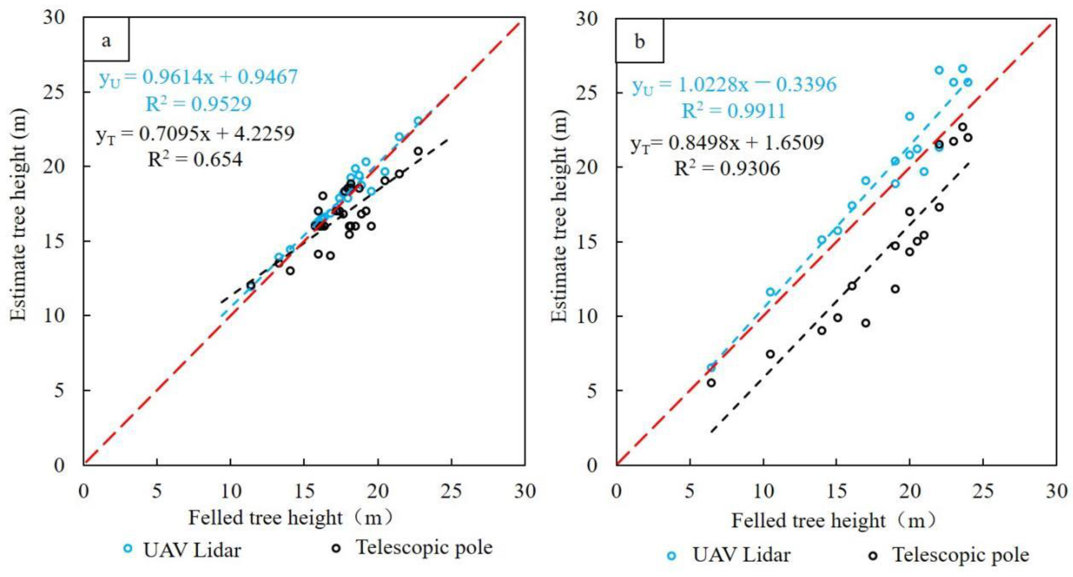
3.1. Comparative Analysis of Tree Heights Measured Using Different Approaches

The comparative analysis of tree heights from different measurement methods indicated that the Lidar-derived tree heights were much closer to the reference heights than the measurements using the telescopic pole. As shown in Figure 2, the Lidar-derived tree height had an R2 value of 0.95 compared with only 0.65 using the telescopic pole for Masson pine, and 0.99 vs. 0.93 for eucalyptus, implying the advantage of using UAV Lidar over a telescopic pole. One important finding shown in Figure 2 is that underestimation was obvious using the telescopic pole as the tree height increased, especially when the tree height was greater than 18 m (the maximum length of the telescopic pole), implying that the individual-tree volume was underestimated when using the conventional tree height measurement method, while using UAV Lidar data could avoid this problem.
Quantitative comparison of bias and RMSE (Table 4) indicated that the tree height using a telescopic pole was underestimated by 4.8% for Masson pine and 6.7% for eucalyptus, while the tree height using UAV Lidar was slightly overestimated by 1.6% and 0.6%, respectively. Overall, the RMSE was 1.6 m for Masson pine and 2.0 m for eucalyptus using a telescopic pole, while the RMSE was reduced to approximately half a meter for both tree species using UAV Lidar. The results imply the advantage in using UAV Lidar over a traditional tree height measurement approach. Table 4 also indicates that eucalyptus had higher measurement errors than Masson pine using a telescopic pole, but the inverse was true using Lidar data, implying that the crown sizes and shapes of different tree species may have affected the measurement accuracy, depending on the methods used.
The tree height was another factor influencing measurement accuracy. When trees taller than the length of a telescopic pole were measured, the uncertainty of the height was much higher than that of the shorter trees using a telescopic pole; however, the Lidar-based method provided robust tree height measurement with no significant difference in uncertainty between tall and short trees, as shown in Table 5. This situation implies the advantage in using Lidar data over a telescopic pole (Tepo in Table 5), especially for tall trees.

3.2. Impacts of Different Allometric Equations on Calculation Accuracies of Single-Tree Volumes

Because double-entry models usually produce more accurate volumes than single-entry models, we took the volumes from the DBH–height-based models as references for comparisons (Table 6). The results show that the DBH-based models underestimated the tree volumes by 0.071 m3 for Masson pine and 0.034 m3 for eucalyptus; the corresponding relative errors were 21.18% and 23.86%, while the RMSEr were 24% and 33.9%, respectively. This situation implies the preference for using DBH–height-based models for tree volume calculation.
The comparison of individual-tree volumes indicates that the volumes from the DBH-based and DBH–height-based models had a strong linear relationship for both species (Figure 3), but the volumes from the DBH-based model were lower than those from the DBH–height-based models, and the discrepancies became larger as the volume increased, especially when the volume was greater than 0.45 m3 for Masson pine (Figure 3). The strongly linear relationship in Figure 3 indicates that a simple linear regression model can be developed to calibrate the tree volume resulting from the DBH-based model, as expressed in Equations (3) and (4).
Ymp =1.1748x + 0.0249,  r2 = 0.96
Yeu = 1.3119x + 0.0002,  r2 = 0.99,
where Ymp and Yeu are the calibrated volume values of Masson pine and eucalyptus, and x is the volume from the DBH-based model. When the volume was relatively small, for instance, less than 0.45 m3, the simple regression model could effectively calibrate the underestimation problem caused by the DBH-based model. However, when the volume was higher, here greater than 0.45 m3, as shown in Figure 3, the calibration effect became poor because of the high variation in volumes. This implies the need to use DBH–height-based models for tall-tree volume estimation.

3.3. Impacts of Tree Height Measurement Approaches on the Calculation Accuracies of Tree Volumes

Comparison of individual-tree volumes calculated using DBH–height-based model and the heights measured by different approaches (Table 7) indicates that the single-tree volume was underestimated by 4.9% for Masson pine and 6.7% for eucalyptus using the tree height from a telescopic pole, but it was overestimated by 1.4% and 0.9%, respectively, using the tree height from the Lidar data. Overall, the RMSEr was 9.1% and 11.8% for Masson pine and eucalyptus, respectively, using a telescopic pole, but it decreased to only 3.4% and 2.4% using the Lidar-derived tree height, implying that the improved tree height measurement accuracy could considerably reduce tree volume estimation errors.
When the telescopic pole was used for measuring tree height, tall trees had much higher volume estimation errors than shorter trees (e.g., lower than the length of the telescopic pole) (see Table 8), but the Lidar-based height did not have this problem, implying the advantage of using Lidar technology to estimate tree volumes over the conventional tree height measurement method.

4. Discussion

4.1. The Importance of Obtaining Accurate Tree Heights

Tree height and DBH are two critical factors used in allometric equations, thus, their measurement accuracies directly affect the calculation accuracy of single-tree volumes. In general, DBH can be measured accurately in the field, but tree height measurement is challenging, especially for tall trees with large crown sizes and in dense tree canopies in mountainous regions [43]. Conventional tree height measurement using a telescopic pole can provide accurate height values when trees are relatively short [44,45]. However, when trees are taller than the measuring tool, the estimated height values may have large uncertainties, as shown in our research: the RMSEr was over 10% when the tree heights were greater than 18 m. In addition, using a telescopic pole to measure tree height in the field is time-consuming and labor-intensive, especially in mountainous regions with dense canopies and steep slopes. The crown sizes and shapes of different tree species also affect measurement accuracy using a telescopic pole because of the difficulty in judging treetops from the ground. Alternatively, UAV Lidar data provide much more accurate tree height values, especially in sites where field measurements are difficult to implement. The top-down measurement makes up for the disadvantages of the conventional tree measurement method. Lidar data can quantitatively and accurately determine the sizes of individual treetops.
Our research shows that UAV Lidar data provided tree heights with an RMSE of 0.54–0.56 m, relatively high errors compared to what some previous research reported [46,47]. The main reason includes the DEM quality and identification accuracy of individual trees due to the point cloud density. A point cloud density of about 40 pt/m² can effectively estimate the tree height of a single tree but may not be sufficient for obtaining precise DEM for sites with dense understories. A high density of point clouds may be needed for dense forests to accurately capture DEM. Another reason may be the underestimated heights of felled trees due to ignoring the stump height and the broken treetops for some felled trees.
We have shown that UAV Lidar data can accurately and effectively measure tree heights and has advantages over the conventional telescopic pole method; for instance, it is not affected by different kinds of tree species with various crown sizes and shapes. However, measuring tree DBH, which is critical for volume estimation, is difficult with UAV Lidar [48]. The synergy of UAV Lidar and terrestrial laser scanning (TLS) data may provide a new way to obtain the parameters of individual trees, because TLS can accurately measure tree DBH, while UAV Lidar can provide more accurate tree heights, especially for tall trees. The adoption of UAV and TLS in forest inventory can facilitate the rapid and accurate retrieval of forest parameters and reduce fieldwork but may raise the cost due to the expensive Lidar equipment. More research is needed to explore the integration of UAV Lidar and TLS data to accurately extract single-tree attributes.

4.2. The Importance of Using DBH–Height-Based Allometric Equations to Improve Tree Volume Calculation Accuracy

Forest inventories based on sample plots generally use a DBH-based model to calculate the tree volume because of the difficulty in measuring tree height in forest sites [10]. Previous research has indicated that the use of improper allometric equations for biomass or growing stock volume estimation may account for 30–70% of the total uncertainty, and is the primary error source [49,50]. For instance, using a DBH-based model to estimate Chinese fir volume yields a relative error between 32% and 60% for individual trees, and between 34% and 34% for sample forest stock volume [13]. Our research also confirmed this big difference between using DBH-based and DBH–height-based models and indicated the necessity of using DBH–height-based models if accurate tree height data are available.
The relationship between DBH and volume is closely related to tree characteristics such as species, age, and density in a unit and external factors such as soil and terrain conditions, all of which affect tree growth. Different sites have various influences on DBH and height growth. For instance, two trees of a specific tree type with the same DBH could have different height growths due to one growing on a mountain ridge or summit and the other one growing in a valley or at the foot of the mountain. Because of the difference in site indices in a large area, the same DBH-based model may produce high uncertainties if it is applied directly to different regions. However, the DBH–height-based model can considerably reduce this problem because of the improved relationship between volume and DBH-height. In reality, DBH–height-based models have not been extensively employed for tree volume calculation. The major reason is the difficulty in precisely measuring tree height in forested regions, in addition to the intense labor requirement and high measurement errors. As UAV technology is gradually being used more in forest inventories, tree height can be more precisely and easily obtained than with conventional tree measurement approaches; thus, the use of DBH–height-based models will be common in the future. Our research indicates the necessity of using the DBH–height-based models, in particular, when individual-tree volume is relatively high.

5. Conclusions

This research selected two typical sites in a subtropical region of China to examine the impacts of tree heights and allometric equations on tree volume calculation accuracy for Masson pine and eucalyptus. The tree height measurements of felled trees were used as reference data to evaluate the measurement accuracy of a telescopic pole and UAV Lidar data, indicating the importance of using UAV Lidar technology to obtain accurate tree height. In particular, UAV technology has advantages over telescopic poles in forest sites with complex forest stand structures. The comparison of the DBH-based and DBH–height-based allometric equations showed the necessity of using a DBH–height-based model for tree volume calculation, especially for tall trees. This research shows that the DBH-based model underestimated tree volume by 23.77% for Masson pine and 33.84% for eucalyptus. UAV technology provides a new tool for reducing this uncertainty, which is a critical data source for forest biomass and carbon studies. More research is needed in combining TLS and UAV Lidar data to accurately extract tree parameters without the onus of in-field measurements.

Author Contributions

Conceptualization, D.L. (Dengsheng Lu) and K.L.; methodology, D.L. (Dengsheng Lu), D.L. (Dengqiu Li) and Y.L.; software and validation, Y.L. and B.Z.; formal analysis, Y.L. and D.L. (Dengsheng Lu); investigation, Y.L., B.Z. and D.L. (Dengqiu Li); resources and data curation, Y.L. and K.L.; writing—original draft preparation, Y.L. and D.L. (Dengsheng Lu); writing—review and editing, D.L. (Dengsheng Lu), D.L. (Dengqiu Li), K.L. and B.Z.; visualization, Y.L.; supervision, project administration, and funding acquisition, D.L. (Dengsheng Lu) and K.L. All authors have read and agreed to the published version of the manuscript.

Funding

This research was financially supported by the National Key R&D Program of China (2021YFD2200400102).

Data Availability Statement

Due to confidentiality agreements, supporting data can only be made available to bona fide researchers subject to a nondisclosure agreement. Details of the data and how to request access are available from Professor Dengsheng Lu at Fujian Normal University.

Acknowledgments

The authors thank Xiandie Jiang, Kai Jian, Ruoqi Wang, Yi Zhang, and Dongguang Fu for their help during the fieldwork.

Conflicts of Interest

The authors declare no conflict of interest. The funders had no role in the design of the study; in the collection, analyses, or interpretation of data; in the writing of the manuscript; or in the decision to publish the results.

References

  1. Mayamanikandan, T.; Reddy, S.; Fararoda, R.; Thumaty, K.C.; Praveen, M.S.S.; Rajashekar, G.; Gummapu, J.; Jha, C.S.; Das, I.C. Quantifying the Influence of Plot-Level Uncertainty in Above Ground Biomass Up Scaling Using Remote Sensing Data in Central Indian Dry Deciduous Forest. Geocarto Int. 2020, 37, 3489–3503. [Google Scholar] [CrossRef]
  2. González-Jaramillo, V.; Fries, A.; Zeilinger, J.; Homeier, J.; Paladines-Benitez, J.; Bendix, J. Estimation of Above-Ground Biomass in a Tropical Mountain Forest in Southern Ecuador Using Airborne Lidar Data. Remote Sens. 2018, 10, 660. [Google Scholar] [CrossRef]
  3. Schlund, M.; Davidson, M. Aboveground Forest Biomass Estimation Combining L- and P-Band SAR Acquisitions. Remote Sens. 2018, 10, 1151. [Google Scholar] [CrossRef]
  4. Tello, M.; Cazcarra-Bes, V.; Pardini, M.; Papathanassiou, K. Forest Structure Characterization from SAR Tomography at L-Band. IEEE J. Sel. Top. Appl. Earth Obs. Remote Sens. 2018, 11, 3402–3414. [Google Scholar] [CrossRef]
  5. Chen, B.; Pang, Y.; Li, Z.; North, P.; Rosette, J.; Sun, G.; Lu, H.; Suárez, J.; Bye, I. Potential of Forest Parameter Estimation Using Metrics from Photon Counting Lidar Data in Howland Research Forest. Remote Sens. 2019, 11, 856. [Google Scholar] [CrossRef]
  6. Lin, W.; Lu, Y.; Li, G.; Jiang, X.; Lu, D. A Comparative Analysis of Modeling Approaches and Canopy Height-Based Data Sources for Mapping Forest Growing Stock Volume in A Northern Subtropical Ecosystem of China. GIsci. Remote Sens. 2022, 59, 568–589. [Google Scholar] [CrossRef]
  7. Schepaschenko, D.; Chave, J.; Phillips, O.L.; Lewis, S.L.; Davies, S.J.; Réjou-Méchain, M.; Sist, P.; Scipal, K.; Perger, C.; Herault, B.; et al. The Forest Observation System, Building A Global Reference Dataset for Remote Sensing of Forest Biomass. Sci. Data 2019, 6, 198. [Google Scholar] [CrossRef] [PubMed]
  8. Hu, Y.; Xu, X.; Wu, F.; Sun, Z.; Xia, H.; Meng, Q.; Xiao, X.; Huang, W.; Zhou, H.; Gao, J.; et al. Estimating Forest Stock Volume in Hunan Province, China, by Integrating In Situ Plot Data, Sentinel-2 Images, and Linear and Machine Learning Regression Models. Remote Sens. 2020, 12, 186. [Google Scholar] [CrossRef]
  9. Chang, K. Conversion of Double-Entry Tree Volume Table to Single-Entry Volume Table. Forest Resour. Manag. 1977, 1, 1–10. (In Chinese) [Google Scholar]
  10. Zeng, W. Discussion on Volume Estimation in Continuous Forest Inventory in China. Cent. South For. Invent. Plan. 2007, 2, 1–3+6. (In Chinese) [Google Scholar]
  11. Li, Q. Developing Stand-Level Model of Stock Volume, Total Biomass and Carbon Storage for Larch Plantations in Heilongjiang Province. For. Res. Manag. 2017, 74–77. [Google Scholar]
  12. Liu, J.; Feng, Z.; Mannan, A.; Khan, T.U.; Cheng, Z. Comparing Non-Destructive Methods to Estimate Volume of Three Tree Taxa in Beijing, China. Forests 2019, 10, 92. [Google Scholar] [CrossRef]
  13. Zeng, W.; Yang, X.; Chen, X. Comparison on prediction precision of one-variable and two-variable volume models on tree-level and stand-level. Cent. South For. Invent. Plann. 2017, 36, 1–6. (In Chinese) [Google Scholar]
  14. He, C. The Key Technology for Precision Measurement in Forest Surveying. Ph.D. Dissertation, Beijing Forestry University, Beijing, China, 2013. [Google Scholar]
  15. Phalla, T.; Ota, T.; Mizoue, N.; Kajisa, T.; Yoshida, S.; Vuthy, M.; Heng, S. The Importance of Tree Height in Estimating Individual Tree Biomass While Considering Errors in Measurements and Allometric Models. AGRIVITA, J. Agric. Sci. 2017, 40, 131–140. [Google Scholar] [CrossRef] [Green Version]
  16. Jurjević, L.; Liang, X.; Gašparović, M.; Balenović, I. Is Field-Measured Tree Height as Reliable as Believed–Part II, A Comparison Study of Tree Height Estimates from Conventional Field Measurement and Low-Cost Close-Range Remote Sensing in A Deciduous Forest. ISPRS J. Photogramm. Remote Sens. 2020, 169, 227–241. [Google Scholar] [CrossRef]
  17. Sibona, E.; Vitali, A.; Meloni, F.; Caffo, L.; Dotta, A.; Lingua, E.; Garbarino, M.; Motta, R. Direct Measurement of Tree Height Provides Different Results on the Assessment of Lidar Accuracy. Forests 2016, 8, 7. [Google Scholar] [CrossRef]
  18. Queinnec, M.; Coops, N.C.; White, J.C.; McCartney, G.; Sinclair, I. Developing A Forest Inventory Approach Using Airborne Single Photon Lidar Data: From Ground Plot Selection to Forest Attribute Prediction. For. Int. J. For. Res. 2022, 95, 347–362. [Google Scholar] [CrossRef]
  19. White, J.C.; Tompalski, P.; Vastaranta, M.; Wulder, M.A.; Saarinen, N.; Stepper, C.; Coops, N.C. A Model Development and Application Guide for Generating an Enhanced Forest Inventory Using Airborne Laser Scanning Data and an Area-Based Approach; Information Report FI-X-018; Natural Resources Canada, Canadian Forest Service, Canadian Wood Fibre Centre: Victoria, BC, Canada, 2017. [Google Scholar]
  20. Latifi, H.; Heurich, M.; Hartig, F.; Müller, J.; Krzystek, P.; Jehl, H.; Dech, S. Estimating Over- and Understorey Canopy Density of Temperate Mixed Stands by Airborne LiDAR Data. For. Int. J. For. Res. 2016, 89, 69–81. [Google Scholar] [CrossRef]
  21. Mielcarek, M.; Stereńczak, K.; Khosravipour, A. Testing and Evaluating Different Lidar-Derived Canopy Height Model Generation Methods for Tree Height Estimation. Int. J. Appl. Earth Obs. 2018, 71, 132–143. [Google Scholar] [CrossRef]
  22. Hernández-Stefanoni, J.L.; Dupuy, J.M.; Johnson, K.D.; Birdsey, R.; Tun-Dzul, F.; Peduzzi, A.; López-Merlín, D. Improving Species Diversity and Biomass Estimates of Tropical Dry Forests Using Airborne LiDAR. Remote Sens. 2014, 6, 4741–4763. [Google Scholar] [CrossRef]
  23. Jiang, X.; Li, G.; Lu, D.; Chen, E.; Wei, X. Stratification-Based Forest Aboveground Biomass Estimation in a Subtropical Region Using Airborne Lidar Data. Remote Sens. 2020, 12, 1101. [Google Scholar] [CrossRef]
  24. Chianucci, F.; Disperati, L.; Guzzi, D.; Bianchini, D.; Nardino, V.; Lastri, C.; Rindinella, A.; Corona, P. Estimation of Canopy Attributes in Beech Forests Using True Colour Digital Images from a Small Fixed-Wing UAV. Int. J. Appl. Earth Obs. Geoinf. 2016, 47, 60–68. [Google Scholar] [CrossRef]
  25. Dainelli, R.; Toscano, P.; Di Gennaro, S.F.; Matese, A. Recent Advances in Unmanned Aerial Vehicle Forest Remote Sensing—A Systematic Review. Part I: A General Framework. Forests 2021, 12, 327. [Google Scholar] [CrossRef]
  26. Dainelli, R.; Toscano, P.; Di Gennaro, S.F.; Matese, A. Recent Advances in Unmanned Aerial Vehicles Forest Remote Sensing—A Systematic Review. Part II: Research Applications. Forests 2021, 12, 397. [Google Scholar] [CrossRef]
  27. Dalla Corte, A.P.; Rex, F.E.; Almeida, D.R.; Sanquetta, C.R.; Silva, C.A.; Moura, M.M.; Wilkinson, B.; Zambrano, A.M.A.; da Cunha Neto, E.M.; Veras, H.F.P.; et al. Measuring Individual Tree Diameter and Height Using GatorEye High-Density UAV-Lidar in an Integrated Crop-Livestock-Forest System. Remote Sens. 2020, 12, 863. [Google Scholar] [CrossRef]
  28. Hartley, R.J.; Leonardo, E.M.; Massam, P.; Watt, M.S.; Estarija, H.J.; Wright, L.; Pearse, G.D.; Melia, N. An Assessment of High-Density UAV Point Clouds for the Measurement of Young Forestry Trials. Remote Sens. 2020, 12, 4039. [Google Scholar] [CrossRef]
  29. Cunha Neto, E.M.; Rex, F.E.; Veras, H.F.P.; Moura, M.M.; Sanquetta, C.R.; Käfer, P.S.; Sanquetta, M.N.I.; Zambrano, A.M.A.; Broadbent, E.N.; Corte, A.P.D. Using high-density UAV-LiDAR for deriving tree height of Araucaria Angustifolia in an Urban Atlantic Rain Forest. Urban For. Urban Green. 2021, 63, 127197. [Google Scholar] [CrossRef]
  30. Chen, Q.; Wang, X.; Hang, M.; Li, J. Research on the Improvement of Single Tree Segmentation Algorithm Based on Airborne Lidar Point Cloud. Open Geosci. 2021, 13, 705–716. [Google Scholar] [CrossRef]
  31. Hu, B.; Li, J.; Jing, L.; Judah, A. Improving the Efficiency and Accuracy of Individual Tree Crown Delineation from High-Density Lidar Data. Int. J. Appl. Earth. Obs. 2014, 26, 145–155. [Google Scholar] [CrossRef]
  32. Dai, W.; Yang, B.; Dong, Z.; Shaker, A. A New Method for 3D Individual Tree Extraction Using Multispectral Airborne Lidar Point Clouds. ISPRS J. Photogramm. Remote Sens. 2018, 144, 400–411. [Google Scholar] [CrossRef]
  33. Holmgren, J.; Lindberg, E. Tree Crown Segmentation Based on A Tree Crown Density Model Derived from Airborne Laser Scanning. Remote Sens. Lett. 2019, 10, 1143–1152. [Google Scholar] [CrossRef]
  34. Liu, H.; Dong, P.; Wu, C.; Wang, P.; Fang, M. Individual Tree Identification Using A New Cluster-Based Approach with Discrete-Return Airborne Lidar Data. Remote Sens. Environ. 2021, 258, 112382. [Google Scholar] [CrossRef]
  35. Man, Q.; Dong, P.; Yang, X.; Wu, Q.; Han, R. Automatic Extraction of Grasses and Individual Trees in Urban Areas Based on Airborne Hyperspectral and Lidar Data. Remote Sens. 2020, 12, 2725. [Google Scholar] [CrossRef]
  36. Peng, X.; Zhao, A.; Chen, Y.; Chen, Q.; Liu, H. Tree Height Measurements in Degraded Tropical Forests Based on UAV-Lidar Data of Different Point Cloud Densities: A Case Study on Dacrydium pierrei in China. Forests 2021, 12, 328. [Google Scholar] [CrossRef]
  37. Chen, Q.; Baldocchi, D.; Gong, P.; Kelly, M. Isolating Individual Trees in a Savanna Woodland Using Small Footprint Lidar Data. Photogramm. Eng. Remote Sens. 2006, 72, 923–932. [Google Scholar] [CrossRef]
  38. Guo, Y.S.; Liu, Q.S.; Liu, G.H.; Huang, C. Individual Tree Crown Extraction of High Resolution Image Based on Marker-Controlled Watershed Segmentation Method. J. Geogr. Inf. Sci. 2016, 18, 1259–1266. [Google Scholar]
  39. Huang, H.; Li, X.; Chen, C. Individual Tree Crown Detection and Delineation from Very-High-Resolution UAV Images Based on Bias Field and Marker-Controlled Watershed Segmentation Algorithms. IEEE J. Sel. Top. Appl. Earth Obs. Remote Sens. 2018, 11, 2253–2262. [Google Scholar] [CrossRef]
  40. Gimenez, B.O.; Dos Santos, L.T.; Gebara, J.; Celes, C.H.S.; Durgante, F.M.; Lima, A.J.N.; Dos Santos, J.; Higuchi, N. Tree Climbing Techniques and Volume Equations for Eschweilera (Matá-Matá), a Hyperdominant Genus in the Amazon Forest. Forests 2017, 8, 154. [Google Scholar] [CrossRef]
  41. Liao, Z. Studies of the Volume Table and Stocking Table Compilations of Eucalyptus Plantations. J. Fujian For. Sci. Tech. 2005, 2, 17–20. (In Chinese) [Google Scholar]
  42. LY/T 2263-2104; Tree Biomass Models and Related Parameters to Carbon Accounting for Pinus Massoniana (The Forestry Industry Standards of the People’s Republic of China). Standards Press of China: Beijing, China, 2014.
  43. Stereńczak, K.; Mielcarek, M.; Wertz, B.; Bronisz, K.; Zajączkowski, G.; Jagodziński, A.M.; Skorupski, M.; Ochał, W. Factors Influencing the Accuracy of Ground-Based Tree-Height Measurements for Major European Tree Species. J. Environ. Manag. 2019, 231, 1284–1292. [Google Scholar] [CrossRef]
  44. Howe, G.T.; Adams, W.T. Clinometer Versus Pole Measurement of Tree Heights in Young Douglas-fir Progeny Tests. West J. Appl. For. 1988, 3, 86–88. [Google Scholar] [CrossRef]
  45. Bell, J.F.; Gourley, R. Assessing the Accuracy of a Sectional Pole, Haga Altimeter, and Alti-Level for Determining Total Height of Young Coniferous Stands. South J. Appl. For. 1980, 4, 136–138. [Google Scholar] [CrossRef]
  46. Ganz, S.; Käber, Y.; Adler, P. Measuring Tree Height with Remote Sensing—A Comparison of Photogrammetric and Lidar Data with Different Field Measurements. Forests 2019, 10, 694. [Google Scholar] [CrossRef]
  47. Wang, Y.; Lehtomäki, M.; Liang, X.; Pyörälä, J.; Kukko, A.; Jaakkola, A.; Hyyppä, J.; Liu, J.; Feng, Z.; Chen, R. Is Field-Measured Tree Height as Reliable as Believed—A Comparison Study of Tree Height Estimates from Field Measurement, Airborne Laser Scanning and Terrestrial Laser Scanning in a Boreal Forest. ISPRS J. Photogramm. Remote Sens. 2019, 147, 132–145. [Google Scholar] [CrossRef]
  48. Xu, D.; Wang, H.; Xu, W.; Luan, Z.; Xu, X. Lidar Applications to Estimate Forest Biomass at Individual Tree Scale: Opportunities, challenges and future perspectives. Forests 2021, 12, 550. [Google Scholar] [CrossRef]
  49. Moundounga Mavouroulou, Q.; Ngomanda, A.; Engone Obiang, N.L.; Lebamba, J.; Gomat, H.; Mankou, G.S.; Picard, N.; Loumeto, J.; Iponga, D.M.; Ditsouga, F.K.; et al. How to Improve Allometric Equations to Estimate Forest Biomass Stocks? Some Hints from A Central African Forest. Can. J. For. Res 2014, 44, 685–691. [Google Scholar] [CrossRef]
  50. Vorster, A.G.; Evangelista, P.H.; Stovall, A.E.; Ex, S. Variability and Uncertainty in Forest Biomass Estimates from the Tree to Landscape Scale: The Role of Allometric Equations. Carbon Balance Manag. 2020, 15, 1–20. [Google Scholar] [CrossRef]
Figure 1. Locations of the experimental sites: Baisha (upper right) and Yuanling (lower right). CHM represents canopy-height model data generated from UAV Lidar.
Remotesensing 14 04410 g001
Figure 2. Relationship between reference data and estimated heights using Lidar and a telescopic pole for Masson pine (a) and Eucalyptus (b).
Remotesensing 14 04410 g002
Figure 3. Comparative analysis of single-tree volumes from different allometric equations.
Remotesensing 14 04410 g003
Table 1. Plot characteristics of eucalyptus and Masson pine.
Plot Number of
All Trees within the Plot
Number of Trees Measured with
the Telescopic Pole
Number of Felled TreesDBH of
Felled Trees
(cm)
Height of Felled Trees (m)
Eucalyptus5117505.1–25.26.5–26.6
Masson pine37303513.1–27.611.4–22.8
Note: DBH, diameter at breast height.
Table 2. Coefficients of the allometric equations for different tree species.
Tree SpecieAllometric EquationabcReference
EucalyptusDBH-based0.000198542.35261
DBH–height-based0.0000717481.8979440.839915[41]
Masson pineDBH-based0.000138812.48492
DBH–height-based0.0000669371.9411400.90485[42]
Note: DBH, diameter at breast height; a, b, and c are model parameters for specific tree species.
Table 3. Scenarios of examining the role of the tree height variable in calculation of single-tree volume.
Role of HeightAllometric EquationDescription
Using height or notDBH-based equation vs. DBH–height-based equation by using reference heightUnderstanding the role of tree height variable in improving calculation accuracy of single-tree volume
Using the measurement methods to obtain tree height
(1)
DBH–height-based equation by using a telescopic pole vs. using reference height
(2)
DBH–height-based equation by using Lidar-derived height vs. using reference height
Understanding the impacts of different tree height measurement methods on calculation accuracy of single-tree volume
Note: DBH, diameter at breast height.
Table 4. Evaluation of measured tree heights using different methods.
Forest
Type
Number of TreesTelescopic Pole vs. Felled TreeLidar vs. Felled Tree
Bias (m)
(Bias%)
RMSE (m)
(RMSEr%)
Bias (m)
(Bias%)
RMSE (m)
(RMSEr%)
Masson pine30−0.84
(−4.8%)
1.57
(9.0%)
0.27
(1.6%)
0.56
(3.2%)
Eucalyptus17−1.31
(−6.7%)
1.96
(9.9%)
0.11
(0.6%)
0.54
(2.7%)
Note: Bias%, relative deviation; RMSE, root mean square error; RMSEr, relative root mean square error.
Table 5. Evaluation of measured tree height results based on different height ranges.
Height Range
(m)
Masson PineEucalyptus
Lidar vs. Felled TreeTepo vs. Felled TreeLidar vs. Felled TreeTepo vs. Felled Tree
RMSE
(m)
RMSEr
(%)
RMSE
(m)
RMSEr
(%)
RMSE
(m)
RMSEr
(%)
RMSE
(m)
RMSEr
(%)
≤180.332.1%1.056.6%0.302.28%0.967.26%
>180.763.9%2.0610.7%0.612.70%2.2510.0%
Note: RMSE, root mean square error; RMSEr, relative root mean square error; Tepo, telescopic pole.
Table 6. Comparison of single-tree volumes based on different allometric equations.
Forest TypeNumber of TreesBias (m3)
(Bias%)
RMSE (m3)
(RMSEr (%))
Masson pine35−0.071
(−21.18%)
0.081
(24.04%)
Eucalyptus50−0.034
(−23.86%)
0.048
(33.90%)
Note: Bias%, relative deviation; RMSE, root mean square error; RMSEr, relative root mean square error.
Table 7. Evaluation of single-tree volume results based on different tree height measurement methods.
Forest TypeNumber of TreesTelescopic Pole vs. Felled TreeLidar vs. Felled Tree
Bias (m3)
(Bias%)
RMSE (m3)
(RMSEr%)
Bias (m3)
(Bias%)
RMSE (m3)
(RMSEr%)
Pine30−0.014
(−4.9%)
0.025
(9.13%)
0.004
(1.36%)
0.010
(3.40%)
Eucalyptus17−0.012
(−6.66%)
0.021
(11.81%)
0.002
(0.86%)
0.004
(2.35%)
Table 8. Evaluation of single-tree volume results based on different height ranges.
Height Range
(m)
Masson PineEucalyptus
Lidar vs. Felled TreeTepo vs. Felled TreeLidar vs. Felled TreeTepo vs. Felled Tree
RMSE
(m3)
RMSEr
(%)
RMSE
(m3)
RMSEr
(%)
RMSE
(m3)
RMSEr
(%)
RMSE
(m3)
RMSEr
(%)
≤180.0052.31%0.0115.14%0.0012.19%0.0036.82%
>180.0133.59%0.0369.9%0.0052.12%0.02410.70%
Note: RMSE, root mean square error; RMSEr, relative root mean squatter error; Tepo. telescopic pole.
Publisher’s Note: MDPI stays neutral with regard to jurisdictional claims in published maps and institutional affiliations.

