Abstract
Covering the full texts of all papers published in MDPI’s Remote Sensing between 2009 and 2021, in-depth scientometric analyses were conducted. Trends in publications show an increase in the overall number of papers. A relative increase in papers using SAR sensors and a relative decrease in papers using optical remote sensing can also be seen. The full-text analyses reveal distinctive styles and writing patterns for papers from different sub-fields of remote sensing and for different countries and even cities. While a slight increase in the readability of abstracts is detected over time, the overall readability of papers is decreasing. Institutional co-authorship analysis reveals the ongoing ‘scientific decoupling’ between China and the USA in remote sensing. Using scientometric full-text analysis, current trends and developments are revealed.
1. Introduction
In today’s science, publishing is an integral part of being a scientist [1]. This practice is the fundament of our modern understanding of science and dates back to the 17th century, when institutionalized structures of modern science emerged, including the publication of results in scientific journals and peer review [2]. Since then, science and scientific publications have experienced strong growth. This has already been shown in one of the first works on scientometric analysis, presenting the dynamic, exponential growth of science [1,3].
Bibliometric methods are used to provide quantitative analyses of written publications [4], and scientometrics is a sub-field of bibliometrics [5]. These analyses typically include geographical [6] or institutional aspects [7], as well as temporal trends [4]. Bibliometrics can provide accessible information on current research directions [8] and on the development of scientific disciplines [9].
Such analyses are conducted in this paper to improve the understanding of current trends and publication practices in the field of remote sensing. To this end, papers published in Remote Sensing, an MDPI open-access journal, are analyzed, starting from the first volume of Remote Sensing, which was published in 2009, until the end of 2021. As an open-access journal, Remote Sensing offers free access to the articles, allowing for full-text analysis.
Typical scientometric analyses rely on the use of databases and meta-information. Three central databases are used for scientometrics: Google Scholar, Scopus, and Web of Science. While Google Scholar has the most entries, Scopus and Web of Science provide relatively similar results [10]. On average, Google Scholar’s unique citations have a much lower scientific impact than citations that are also found by Web of Science and Scopus [11], which can be seen as a qualitative advantage of those.
Using these databases gives a complete view of the indexed publications, but limits the use of information available to meta-information for analysis. A full-text analysis allows for more detailed and extensive analyses of a subset of the articles. Previous works using full-text analysis for scientometric analyses are limited. Some cover just a few papers [12]. More extended full-text analyses focus on the frequency of keywords in the text to determine trends [13]. In contrast, database-based scientometric analyses rely on keywords saved in the database to identify current research topics and trends [14].
As full-text analyses are based on a subset of the available publications, the representativeness of this subset is an issue. Including all papers published in one of the leading journals in the field of remote sensing gives a certain representability. However, each journal has a specific personality and attracts different papers, authors, and readers, so an analysis only focusing on papers published in Remote Sensing is limited.
The open-access and author-centric business model of MDPI’s Remote Sensing also impacts the representativity of the analysis. Not all authors can or want to afford the article publication fees, so papers that would fit well into the scope and ‘personality’ of Remote Sensing may be submitted elsewhere.
Scientometric analyses are also commonly criticized for being overused and often problematic, especially if misused for university or scientist rankings [15]. Scientometrics play a critical role in the publish-or-perish culture of today’s science. Most criticism is about the overuse of citations, especially with the misuse of citations as a quality indicator. For this reason, analyses in this paper use citations only sparsely. Readers should be aware of the limited validity of citations as a quality indicator and even as an impact indicator.
Although to be considered carefully, citations are nevertheless an indicator of a paper’s impact and the relevance of a journal. In Table 1, the five most cited articles in the field of remote sensing are shown, and in Table 2, the five most cited articles in MDPI’s Remote Sensing are shown.

Table 1.
Five most cited articles in the field of remote sensing published between 2010 and 2021 according to the Web of Science (accessed on 20 June 2022).
Table 2.
Five most cited articles in Remote Sensing according to the Web of Science (accessed on 20 June 2022).
As can be seen from Table 1 and Table 2, review papers are commonly found under highly cited papers, cannibalizing original research [26]. It can also be seen that the most cited articles in Remote Sensing have significantly fewer citations than the overall most cited articles in Remote Sensing.
The analyses in this paper focus on quantitative analyses of current research trends in remote sensing, the style and readability of articles, and the spatio-temporal patterns of co-authorship.
Co-authorship is a common theme in scientometrics. For example, Narin et al. [27] showed that internationally co-authored papers are cited twice as often as papers from authors of a single country. However, typically authorship is analyzed topologically or within organizational patterns (countries, universities, etc.), while detailed geographical patterns are ignored. Using textual analysis and geo-location tools, a detailed geographical analysis is presented in this paper for the first time for remote sensing.
With a full-text analysis, additional information is available. This allows for a look into the common structure of papers and regional, temporal, and research-area-related differences in paper structure and the readability of papers published in Remote Sensing.
Based on the papers published in Remote Sensing, current trends and relevant topics are analyzed for their temporal and spatial distributions. Using the available full texts of the papers, differences in paper structures are analyzed to derive spatial and temporal patterns, which can help to better understand and measure the structure of the remote sensing science from a different viewpoint that goes beyond authorship and keyword analyses.
Structural inequalities are affecting science. Remote sensing requires relatively large investments, and financial constrains are a major source of inequality. Another inequality is related to the use of English in scientific publications [28]. Being able to publish in English is essential, as 98% of publications in science are written in English, establishing English as the lingua franca of science [29]. In this paper, readability is analyzed with respect to differences in readability for different countries and sub-disciplines, where readability and structure are proxies for measuring the use of the English language. Analyzing these can help to better understand the influence of English as a barrier in remote sensing, a scientific field where the majority of contributions come from non-English speakers.
2. Materials and Methods
The analysis in this paper is based on the full text of 19,289 Remote Sensing articles downloaded from MDPI, which is the complete set of articles published in Remote Sensing between 2009 and 2021. The texts from the papers’ HTML versions were organized in a database for more accessible analysis. Based on the structure of the HTML files, the texts were separated into sections, which were saved separately in the database. Accordingly, keywords, author information, and references were derived and saved for each article. All of this information was used in subsequent analyses. Keywords were used for classification, affiliations for location-based analysis, and references for examining the number of references per paper.
In this paper, Remote Sensing is used for papers published in the Remote Sensing journal, while remote sensing is used for the field of remote sensing. Analyses covering the whole field of remote sensing are based on a database analysis using the ‘Science Citation Index (SCI)’ of the Web of Science. Search queries in the Web of Science use the topic “Remote Sensing” (SU = ‘Remote Sensing’) to identify articles published in the field of remote sensing.
2.1. Text and Keyword Classification
Common bibliometrics focus on the keywords selected by the authors for content classification. In this paper, keywords are used for a preliminary analysis of content and for identifying classes and themes for the subsequent classifications. For this purpose, the keywords are visualized as word clouds, and their annual average growth rates are analyzed.
The complete full texts of all 19,289 articles published between 2009 and 2021 in Remote Sensing are analyzed. This allows for the analysis of the structure of articles, including differences in sections concerning, for example, the number of words.
The full-text classification was supported by the natural language processing framework Spacy [30]. Based on this, key nouns were separated and classified if they belonged to a particular class. The number of words classified to a specific class was weighted by the section in the text, with higher weights given to the title and abstract. For an article to be classified, the class assigned must significantly outweigh the other classes to guarantee unambiguous classification and to ensure that one article is only attributed to one class. Of the 19,289 articles, 73% were classified into one of the five classes for sensors, and 71% were classified for applications.
2.2. Article Readability Analysis
Readability is vital in scientific communication. Ultimately, a publication needs to be understood to make any impact. With most scientists publishing in the field of remote sensing not being native English speakers, good readability is even more important to get the message across. Readability can be automatically measured, at least to some degree. Several approaches are commonly used for this. One of the first formulas for estimating readability is the Flesch Reading Ease score, which was published in 1948 [31]. The score is calculated with
where ASL is the average sentence length and ASW is the average word length in syllables. The Flesch Reading Ease score ranges from 0–100, although higher values and values below 0 are possible. Values between 30 and 50 are college-level reading; texts between 10 and 30 are very difficult to read, but can be understood by university graduates, while values below 10 are extremely difficult to read. Flesch Reading Ease scores between 20 and 50 are, therefore, considered suitable. Certain readability scores (often >48 points) are mandatory for many official documents in various countries [32].
In addition, in 1948, Dale and Chall published their readability index [33]:
where PDW is the percentage of difficult words not on the Dale–Chall word list and ASL is the average sentence length. The values of the Dale–Chall score roughly correspond to grade levels. A score between 8.0 and 8.9 should be easily understood by an average 11th–12th grade student, and a college student should easily understand a score of 9.0–9.9. In contrast to the Flesch Reading Ease score, lower values are better in the Dale–Chall scoring system.
2.3. Affiliation and Location Analysis
The study of research collaboration based on co-authorship is a common practice [7]. According to Melin and Persson [7], a scientific document is co-authored if it has more than one author and institutionally co-authored if it has more than one author address. This paper focuses on institutionally co-authored papers, which are defined here as having more than one affiliation. In the analysis of countries or cities of origin of a paper analyzed using the papers from Remote Sensing, only the country or city of the first affiliation is used in the analysis. This approach gives more focus on the main contributor of a paper in the affiliation-based analyses.
In Remote Sensing, affiliations are well formatted. The country information can be derived automatically, as it is the last part of the affiliation information in the format used on the website of MDPI. Country information can also be diverse, with different writing and abbreviations used. However, the country names are well formatted in the case of Remote Sensing.
Information about the universities, research institutes, and other authors’ affiliations is often tricky due to ambiguities in writing, abbreviations used, etc. For a less ambiguous analysis, cities are used for the spatial analysis below the country level. City information is often less ambiguous than affiliation names, but there are still large variations in names and writing.
City names are derived from their position in the affiliation formatting. The strings supposedly containing city information are then cleaned—e.g., numbers, which are often PO codes, are removed. There remain a rather large number of errors and problems. To identify city names, the natural language processing (NLP) framework Spacy [30] was used, looking for location names. Afterward, the thus-identified city (or location) names were geocoded with the geolocator of Microsoft Bing. Only affiliation locations that could be identified and geocoded with the above-mentioned methods were used for the spatial analysis below the country level described in Section 3.4.
3. Results
Within the general trend of the exponential increase in the number of scientific publications [1], the overall number of articles published in the field of remote sensing increased between the years of 2009 and 2021, as shown in Figure 1.
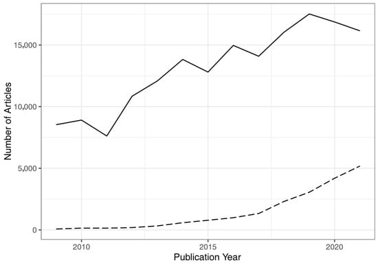
Figure 1.
Articles published from 2009 to 2021 in the field of remote sensing according to the ‘Web of Science’ (solid line) and articles published in Remote Sensing (dashed line).
The overall number of publications in the field of remote sensing is shown as a solid line in Figure 1, while the articles published in Remote Sensing are shown as a dashed line. The increase in articles published in Remote Sensing is relatively faster than the general trend, pointing to the increasing relevance of Remote Sensing in the field. With a share of about 32% of articles published in the field of remote sensing in 2021, analyzing articles from Remote Sensing can be considered somewhat representative for the research field, at least in recent years. Biases can be expected with respect to the open-access publishing model and the resulting article processing charges, as well as due to differences in recognizing Remote Sensing as a scientific venue.
In Figure 2, the development of the publications for the four countries with the most publications in Remote Sensing is shown. Figure 2 shows the development of publications in the field of remote sensing according to the Web of Science on the left side, and the articles published per country in Remote Sensing can be seen on the right side of Figure 2.
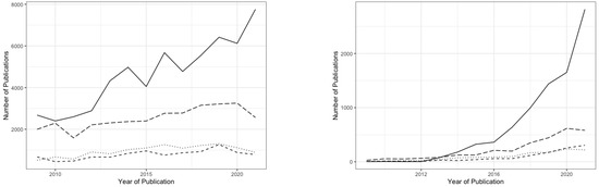
Figure 2.
Articles published in the field of remote sensing (left) and in Remote Sensing from 2009 to 2021 by country (China = solid line; USA = long dashed line; Germany = dotted line; Italy = dashed line).
However, there is a difference between the precise meanings of the numbers on the left and right sides of Figure 2. The statistics from all publications published in the field of remote sensing on the left side include all papers with one affiliation to a country, so one paper can be counted several times in these statistics. On the right side of Figure 2, only the country of the first affiliation is counted for articles published in Remote Sensing.
The trends in Figure 2 are similar for the left and right sides. A stronger increase in publications from China published in Remote Sensing with respect to the overall trend in the field of remote sensing can be seen. Remarkable is the decreasing trend of numbers of publications in 2020 and 2021 in many countries, presumably due to the strain on science from the pandemic.
3.1. Research Topics and Research Trends in Remote Sensing
Analyzing trends in research is one of the main goals of scientometrics. For a first analysis, the keywords of articles published in Remote Sensing and their changing frequencies over time are analyzed. To visualize the keywords, word cloud images are shown in Figure 3.
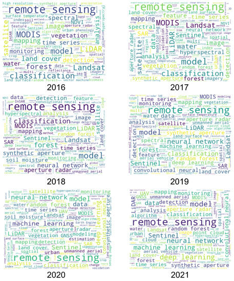
Figure 3.
Word clouds derived from keywords of articles published in Remote Sensing between 2016 and 2021.
Figure 3 shows word cloud images derived from keywords of articles published in Remote Sensing between 2016 and 2021. The changing importance of keywords over time can be seen, as in a word cloud image, the size of the shown words depends on the frequency of their appearance. Over the years, the most prominent term is ‘remote sensing’, which is no surprise.
The word cloud images give us a first look into changing trends. Changing trends in sensors, with MODIS and Landsat being prominent in the first years, while Sentinel has recently become more frequently mentioned, can be seen. Methods changed as well, with ‘classification’ being prominent in 2016, while terms like ‘machine learning’ and ‘neural network’ were more prominent in 2020 and 2021.
Different applications can also be identified in Figure 3, for example, from terms such as ‘water’, ‘land cover’, or ‘urban’.
For a more detailed analysis, the keywords are ranked by their overall appearance between 2009 and 2021 and by their average annual growth rate for the last three years in Table 3 and Table 4. As some keywords are written or abbreviated differently, such differences were edited. For example, for SAR, ‘SAR’ and ‘Synthetic Aperture Radar’ were combined. Similarly, ‘UAV’ and ‘unmanned aerial vehicle’, as well as ‘Convolutional Neural Network’ and ‘Convolutional Neural Networks’, were merged.
Table 3.
Number of times that keywords are used in articles published in Remote Sensing and average growth rate for the last three years sorted by the number of keywords.
Table 4.
Number of times that keywords are used in articles published in Remote Sensing and average growth rate for the last three years sorted by the average growth rate.
The most used keyword is ‘Remote Sensing’. Many of the often-used keywords refer to sensors. The fastest growing keywords shown in Table 4 refer to methods, with ‘Deep Learning’ and ‘Convolutional Neural Network’ being the fastest growing keywords. In terms of future research trends, the trend toward deep learning is clearly shown. Further trends are shown in the rise of UAVs and the Sentinel satellites, with Sentinel-1 and SAR showing strong numbers and growth. Using the ‘Google Earth Engine’ is becoming more popular as well. Interestingly, GNSS, GIS, and photogrammetry also are highly trending keywords in Remote Sensing.
In Figure 4, the trends of selected keywords over the years are shown using the most common keywords: ‘Remote Sensing’, ‘SAR’, ‘MODIS’, ‘Deep Learning’, and ‘LIDAR’. Additionally, ‘Google Earth Engine’ has been added as a fast-growing keyword.
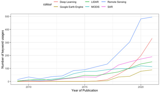
Figure 4.
Number of selected keywords used in articles published in Remote Sensing between 2009 and 2021.
As we can see in Figure 4, ‘Deep Learning’ is growing very quickly as a keyword in Remote Sensing. ‘MODIS’, on the other hand, is stagnating. However, the analysis of keywords is limited, as it misses context. Using the full-text analysis of the freely available Remote Sensing articles allows for a better understanding of the actual trends over time. For this purpose, the analysis is separated into sensors and applications. The selection of the relevant groups is based on the keyword analyses shown above, as well as a subjective interpretation of the most common sensors/platforms and applications.
The five most common sensor and platform types were optical sensors, SAR sensors, LiDAR, UAV, and hyperspectral sensors, which were then selected for the full-text analysis, which looked for relevant keywords and weighted their appearance. Only articles that showed a clear and dominant sensor or application were analyzed in the following results. This approach ignored articles that did not show a clear categorization to avoid misclassification, but unfortunately also ignored any multi-sensor or multi-application approaches, which is a limiting factor for the results shown below.
In Figure 5, the results of this analysis for the given sensor/platform types are shown, with the absolute number of articles published in Remote Sensing that could be clearly classified on the left side of Figure 5 and the relative fraction on the right side of Figure 5.
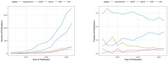
Figure 5.
Number of articles published in Remote Sensing using a given sensor (left) and fraction of articles published in Remote Sensing using a given sensor (right).
The fraction of articles shown on the right side of Figure 5 is more relevant for the analysis. The majority of articles are concerned with optical remote sensing, but this is declining, with a relatively strong increase in articles using SAR data. LiDAR is relatively declining as well, while articles using UAVs are rising over time.
The availability and accessibility of data play an important role here. SAR data are becoming increasingly available, and the increase in papers published about SAR in 2016, as shown in Figure 5, indicates the importance of the Sentinel-1 mission for this. This is in contrast to previous publications that saw the fraction of radar-related papers in the field of remote sensing as relatively constant [34]. The trend towards more SAR-related research might be attributed to the more available SAR data, as the increase is related in time to the launch of Sentinel-1, and similar increases in InSAR-related research are, for example, shown in [34] for the year 2008 after the launch of COSMO-SkyMed and TerraSAR-X.
Not only sensors and platforms are of interest, but also the applications for which the data are being used, as well as changing trends. In Figure 6, the changes in articles published for a specific application are shown over time. The applications included in the analysis are agriculture, water, the cryosphere, disasters, and the urban field.
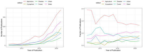
Figure 6.
Number of articles published in Remote Sensing for a given application (left) and fraction of articles published in Remote Sensing for a given application (right).
Again, the relative trends shown on the right side of Figure 6 are more relevant for the analysis of trends in remote sensing. The most common application in remote sensing is agriculture. However, agriculture is showing a relatively declining trend, as is urban remote sensing, which was even the second most used application until 2016 and dropped down to the fourth place, behind water and the cryosphere, with both becoming increasingly important. Remote sensing for disaster mitigation remains important, but relatively stable in its relative fraction of articles published in the field.
The analysis of the changing trends in remote sensing over time is only one side of the picture. The spatial distribution is also of interest. In Figure 7, the relative fraction of articles using different sensors is shown for China, the USA, Germany, and Italy. These are the four countries with the most publications in Remote Sensing.
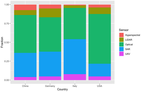
Figure 7.
Fractions of articles published in Remote Sensing using a specific sensor by selected countries.
Figure 7 shows that the USA has the largest percentage of articles using optical sensors, while Italy has the largest fraction of articles using SAR. Germany is relatively strong in LiDAR research, while China is balanced and has the largest fraction of hyperspectral articles.
In Figure 8, the relative fractions of articles for a certain application are shown for China, USA, Germany, Italy, and Brazil.
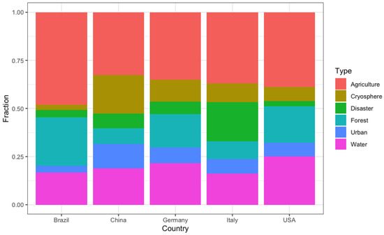
Figure 8.
Fractions of articles published in Remote Sensing using a specific application by selected countries.
China shows the largest fraction of articles published for applications in the cryosphere and urban fields, as shown in Figure 8. Italy, on the other hand, has a large fraction of articles in the field of disaster mitigation, while Brazil has a large fraction of articles in forestry. Brazil has been included in this figure as an additional example to demonstrate that the local needs and requirements of different countries play a role in the research undertaken.
3.2. Properties of an Average Remote Sensing Paper
For the analysis of the properties of different sections in a Remote Sensing paper, the relatively fixed structure of Remote Sensing papers is used. These sections are: Introduction, Methods, Results, and Discussion. Because the Conclusion section is optional in the standard format of papers in Remote Sensing, the Conclusion section is ignored in the analysis. From the 19,289 papers analyzed, 9799 fit into the narrow automatic analysis requirements that allow the matching of the sections of a paper into these categories, which is to say that about half of the papers strictly follow this IMRD(C) schema. Other papers have often just a slightly different structure—for example, they have an extra section for the literature review. To allow for clear comparison, only the 9799 papers fitting into this narrow schema are analyzed in this section.
In Table 5, the average word count and average number of equations per sections are shown. The overall word count of a complete paper is greater than the sum of the word counts of the introduction, method, result, and discussion section because, in addition to these sections, many papers include conclusions, acknowledgements, annexes, abstracts, etc.
Table 5.
Average word counts and average numbers of equations per article section.
Based on the results shown in Table 5, it can be seen that, on average, the Introduction is the largest section, with the vast majority of equations—4.9 on average per paper—in a Remote Sensing article. This is followed by the Methods section, with an average of only 0.5 equations per article.
As can be seen in Figure 9, in the first years of Remote Sensing, articles tended to be longer, while in recent years, the average number of words per article tended to be below 7000 words. The average number of equations shows an increasing trend. A detailed overview of the fractions of words per article over time is shown in Table 6.
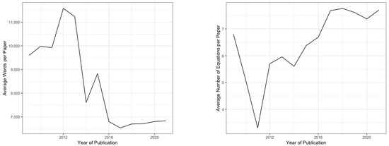
Figure 9.
Average number of words (left) and average number of equations (right) per article published between 2009 and 2021 in Remote Sensing.
Table 6.
Average fraction of words per article section between 2014 and 2021.
Table 6 shows the development of the relative sizes of the different sections in Remote Sensing papers from 2014 to 2021. Overall, a slight increase in the relative size of the Introduction and Method sections over time can be seen, with the exception of the year 2015, which showed a huge spike in the relative size of the Methods sections and relatively small Introduction sections. With comparatively few papers published in the early years, outliers were more common, which was also the reason for the table to start in the year 2014, as from 2014 onwards, far more than 100 papers were published per year, which ensures more reliable results.
Regional differences can be found in the structures of the papers. As shown in Figure 10, the wordiest papers in Remote Sensing are found in papers with first affiliations from Germany, while East Asian papers seem to have, on average, fewer words but more equations per paper. These structural differences are also reflected in the relative sizes of the sections shown in Table 7.
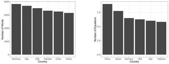
Figure 10.
Average numbers of words (left) and average numbers of equations (right) for selected countries of first affiliations of articles published in Remote Sensing.
Table 7.
Average fraction of words per article section of selected countries.
As can be seen from Table 7, there are significant differences in the article properties between countries. Three main groups of papers can be distinguished. There is the US style, which has long introductions covering >28% of the words in an article. This style can also be found in other anglophone countries, such as the UK and Australia, but also in other countries such as Japan and Brazil. It seems to be the most common style. Distinctive from the US style, the Chinese style has a longer Methods section. Papers from South Korea are relatively similar to this style. The third main style is the European style, which is mainly represented by Germany and Italy, but is also found in, for example, France and Spain, with longer Results and Discussion sections. Smaller distinctive styles can also be found, such as that of Pakistan, with a very long Methods section on average. In detail, more local differences can even be found. The Chinese style is, for example, more distinct in the cities of Wuhan (25.6% Methods section and 9.7 equations per paper) or Hefei (30.1% Methods section and 9.0 equations per paper) in contrast to Beijing (24.6% Methods section and 8.7 equations per paper).
Distinctive stylistic differences are not only seen between countries, but also between the sub-domains of remote sensing. In Figure 11, the average number of words per article (left) and the average number of equations per article (right) for articles concerning different sensors/platforms are shown.
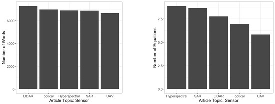
Figure 11.
Average numbers of words (left) and average numbers of equations (right) for selected sensors discussed in articles published in Remote Sensing.
Articles using SAR sensors show significantly lower average numbers of words and a relatively high number of average equations. The highest number of equations can be found in papers dealing with hyperspectral sensors, while papers using UAVs show far fewer equations per paper. SAR articles have the relatively largest Methods and Discussion sections, as shown in Table 8. SAR articles, on the other hand, have the shortest introductions, while LiDAR articles have the longest introductions, and articles using UAVs have the largest Results sections.
Table 8.
Average fraction of words per article section of articles using the main remote sensing sensors.
The stylistic differences between the different sub-domains of remote sensing are also inter-connected with the stylistic differences in the different countries shown above. Different countries have different research emphases; therefore, an ‘Italian style’ of writing will influence the average ‘SAR style’ of articles, and vice-versa.
3.3. Article Readability
Readability is important for successful scientific communication. High levels of readability should be achieved, making the work understandable without compromising on precise language. To analyze and understand the results from the Dale–Chall and Flesch Reading Ease scores, the abstracts with the best and worst Dale–Chall and Flesch Reading Ease scores from 2018 are analyzed. This allows for a qualitative comparison of the results. According to Dale–Chall, the most readable abstract in 2018 was [35]:
“The thickness of oil spills on the sea is an important but poorly studied topic. Means to measure slick thickness are reviewed. More than 30 concepts are summarized. Many of these are judged not to be viable for a variety of scientific reasons ... One of the difficulties is that ground truthing and verification methods are generally not available for most thickness measurement methods.” [35](Dale–Chall: 9.6, Flesch: 35.6)
The following abstract was the least readable in 2018 according to the Dale–Chall score [36]:
“Dictionary pruning step is often employed prior to the sparse unmixing process to improve the performance of library aided unmixing. This paper presents a novel recursive PCA approach for dictionary pruning of linearly mixed hyperspectral data motivated by the low-rank structure of a linearly mixed hyperspectral image ... Extensive simulated and real image experiments exhibit the efficacy of the proposed algorithm in terms of its accuracy, computational complexity and noise performance.” [36](Dale–Chall: 15.5, Flesch: 14.2)
The extreme examples are not identical when looking at the Flesch Reading Ease score, though. According to Flesch Reading Ease score, the most readable abstract in 2018 was [37]:
“The present-day kinematic features of the different segments of the Altyn Tagh Fault (ATF) have been well-studied using geodetic data. However, on the eastern segment of the ATF at 91.5–95°E, high spatial resolution deformation has not been previously reported. Here, we processed 185 interferometric synthetic aperture radar (InSAR) images from three descending tracks of the C band ERS-1/2 and Envisat satellites spanning 1995–2011 and obtained the average deformation velocity field ... Our InSAR observations support the undeformed blocks model of the Indo-Eurasian collisional mechanism at the northern margin of the Tibetan plateau.” [37](Dale–Chall: 13.5, Flesch: 55.6)
Interestingly, the Dale–Chall score is 13.5, which is not very good for this abstract. The least readable abstract in 2018 according to the Flesch Reading Ease score was [38]:
“Ice velocity is one of the products associated with the Ice Sheets Essential Climate Variable. This paper describes the intercomparison and validation of ice-velocity measurements carried out by several international research groups within the European Space Agency Greenland Ice Sheet Climate Change Initiative project, based on space-borne Synthetic Aperture Radar (SAR) data. The goal of this activity was to survey the best SAR-based measurement and error characterization approaches currently in practice ... This allows several recommendations to be formulated, in particular concerning procedures which can reduce the impact of analyst decisions, and which are often found to be the cause of sub-optimal algorithm performance.” [38](Dale-Chall: 14.6, Flesch: −26.4)
These examples show that the Dale–Chall score and Flesch Reading Ease score are related, but the results differ. In the author’s subjective opinion, the Dale–Chall score provides more reliable results, as the abstracts considered to be the best are subjectively more readable.
Using the 9799 papers published in Remote Sensing between 2009 and 2021 that allowed the automated identification of the Abstract, Introduction, Methods, Results, and Discussion sections, the readability of the different sections was analyzed using the Flesch Reading Ease [31] and Dale–Chall scores [33]. The average readability scores are shown in Table 9.
Table 9.
Average readability scores of different sections of papers published in Remote Sensing.
As can be seen from Table 9, the scores and their interpretations differ between the readability metrics. Both show very low readability for the abstracts that are measured to be the most difficult to read by the Dale–Chall score. Methods sections are generally much more readable and score the highest with the Flesch Reading Ease score. Results are considered the most readable when using the Dale–Chall score, while they are, on average, considered much less readable when using the Flesch Reading Ease score.
The large differences between the scores leave room for interpretation. Generally, abstracts seem far less readable than the majority of the parts of the texts, with the Methods and Results sections being, on average, the most readable parts of a paper in Remote Sensing.
To analyze the readability differences in papers from different countries, the four countries with the most publications in Remote Sensing, China, USA, Germany, and Italy, are analyzed in Table 10 using the Dale–Chall score and in Table 11 using the Flesch Reading Ease score.
Table 10.
Average Dale–Chall scores of article sections from selected countries.
Table 11.
Average Flesch Reading Ease scores of article sections from selected countries.
Again, the results of the Dale–Chall and Flesch Reading Ease scores were quite different, as shown in Table 10 and Table 11. According to the Dale–Chall score, the most readable papers were written by authors from Germany, which had the most readable abstracts and introductions. The worst abstracts were from Italy, and the least readable introductions were written by authors from China. In contrast, according to the Flesch Reading Ease score, the most readable abstracts and introductions were written by authors from China, and the least readable were from Italy.
Both scores agree on the weak readability of abstracts from Italy. However, the comparably good scores of abstracts and introductions of authors from China with the Flesch Reading Ease score are certainly discussable and are in contrast to the author’s intuition. The Dale–Chall scoring is intuitively more correct, at least in the subjective opinion of the author.
Significant differences can not only be identified between countries, but also in countries and relatively culturally homogenous areas. On average, articles from Wuhan in China show the best readability of abstracts in China (Dale–Chall score of 12.97), but the second worst Introduction sections (Dale–Chall score of 13.50); only Xi’An scored worse (Dale–Chall score of 13.64). Papers from Beijing, on the other hand, have significantly more readable introductions (Dale–Chale score of 13.18). Such differences also hint at significant readability differences between rather technical papers and more application-oriented papers. As a side note, the most readable abstracts are found to be from Oberpfaffenhofen/Wessling, Germany and London, UK.
Such significant writing differences in style, readability, and form between countries and between the sub-disciplines of the field of remote sensing are not surprising. The significance of the differences and the clear appearance of distinct styles in writing are interesting. Most surprising, at least for the author, are the differences between cities—for example, between a Beijing style and a Wuhan/Hefei style of writing. Similar differences can be found in other countries as well. However, due to the more significant number of papers from China, more samples exist for each city, making the analysis more robust. In this respect, analyses focusing on cities suffer from well-known problems in scientometrics, with different address formats, names, abbreviations, etc., which can hinder the automated aggregation of papers from a specific city. An excellent example of this effect in this study would be the German Aerospace Center (DLR), with papers attributed to Oberpfaffenhofen and Wessling. Additionally, Wessling is sometimes written as the original German Weßling, further complicating the analysis. Nevertheless, a particular DLR style can be found, especially in terms of the above-average readability of their papers.
Analyzing readability based on the countries of the first affiliation of a paper is not the only result of interest. Another aspect is the development of readability over time. For this, the Dale–Chall readability scores of abstracts and introductions published in Remote Sensing between 2014 and 2021 are shown in Figure 12.
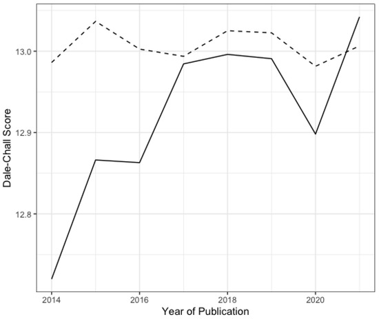
Figure 12.
Dale–Chall readability scores for abstracts (dashed line) and introductions (solid line) between 2014 and 2021.
The readability of introductions has decreased over time. While abstracts show less readability in general, there was a slight trend toward improving their readability between 2014 and 2021. The overall trend of decreasing readability in introductions reflects a trend of decreasing readability of the overall papers published in Remote Sensing, which might be a larger trend in the field of remote sensing, engineering, or academic publishing in general.
3.4. Scientific Cooperation and Connectivity
Scientific cooperation and communication are important drivers for progress. A way of measuring scientific cooperation and connectivity is to look at the number of authors and the number of affiliations per paper. In Figure 13, the average numbers of authors (left) and affiliations (right) of articles published in Remote Sensing are shown.
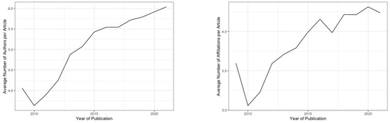
Figure 13.
Average numbers of authors (left) and average numbers of affiliations (right) for articles published in Remote Sensing from 2009 to 2021.
Figure 13 shows increasing trends for the average numbers of authors and affiliations for papers published in Remote Sensing. The overall increase in authors and affiliations per paper is a trend that is generally seen in scientific publications [1]. Similarly to the trend of increasing authors and affiliations per paper, the number of cited references can also be seen as a form of communication. In Figure 14, this is shown as a development in time and for selected countries.
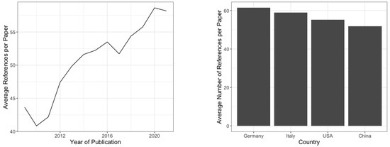
Figure 14.
Average number of references per paper shown per year (left) and for selected countries (right) for papers published in Remote Sensing from 2009 to 2021.
As can be seen in Figure 14, the number of cited references is also continuously increasing. However, on average, the number of cited references also differs between countries, as shown in Figure 14.
The temporal as well as spatial properties of these trends are of interest. To learn more about the spatial connectivity of scientists publishing in Remote Sensing, the affiliations’ locations were analyzed to identify cities. The cities were then geocoded to establish a location for each given affiliation. Affiliations where the cities or their geolocations were not identified correctly are ignored in the following analysis. However, errors in finding cities and their geolocation are not distributed equally. Affiliations in smaller cities and some non-English speaking countries are more affected by this. Inconsistencies can, furthermore, arise from differences in identifying an affiliation’s city. Such inconsistencies affect the following analysis.
In Figure 15, the connection of papers with the first affiliation inside China to the other affiliations of the same paper are shown.
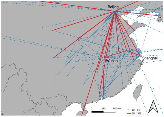
Figure 15.
Connections of affiliations of articles published in Remote Sensing with an affiliation in China.
As shown in Figure 15, there are many connections between affiliations inside of China, as well as relatively strong connectivities to the USA and Europe. The overall connectivity shows the centralistic structure of China’s research environment, with most connections leading to Beijing, as well as strong connections between Wuhan and Nanjing and between Shanghai and Nanjing.
In Figure 16, the connections between affiliations with papers with the first affiliation from the USA are shown.
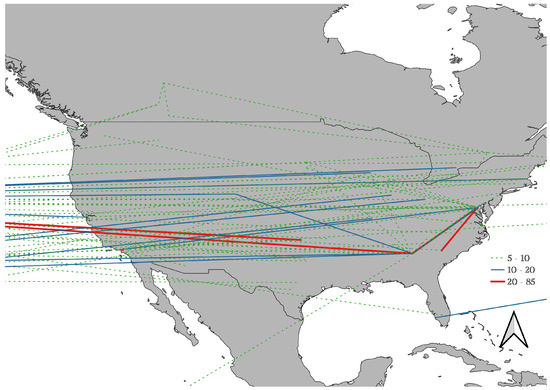
Figure 16.
Connections of affiliations of articles published in Remote Sensing with an affiliation in the USA.
The connectivity patterns in the USA, as shown in Figure 16, are quite different from those in China. There is no visibly centralistic connectivity pattern. Furthermore, a large amount of international interconnectivity can be seen for papers published in Remote Sensing with a first affiliation in the USA. The connectivity patterns in Europe are again different, as shown in Figure 17, showing the connectivity of articles with first affiliations in countries from the EU and the UK.
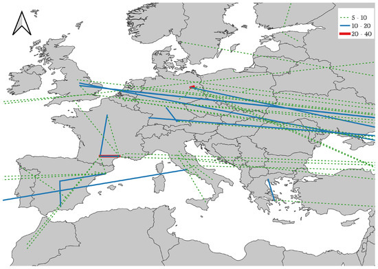
Figure 17.
Connections of affiliations of articles published in Remote Sensing with an affiliation in the EU and the UK.
There is no distinct inter-European connectivity to be seen for articles published in Remote Sensing. Connections are seen in separate countries, for example, inside France, Spain, and Germany, but very few are seen between European countries. More connectivity with countries outside Europe than intra-European connections can be seen. Europe’s lack of widespread interconnectivity is of concern. Narin et al. [27] already showed in 1991 that cooperation in Europe mainly follows linguistic and cultural factors. This still seems to be the case for papers published in Remote Sensing today.
Similarly, the connectivity between African countries is very limited, as shown in Figure 18. Most of the connections between affiliations of articles from Africa are with countries outside of Africa.
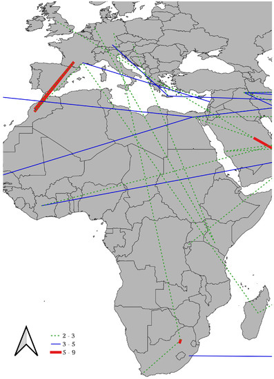
Figure 18.
Connections of affiliations of articles published in Remote Sensing with an affiliation in Africa.
The overall trend of scientific connections is not only influenced by scientific necessities, but also by the overall political situation. Increased tensions can hamper international cooperation in science. To analyze the influence of geo-politics on scientific cooperation, papers from international cooperations from the USA and China are shown in Figure 19.
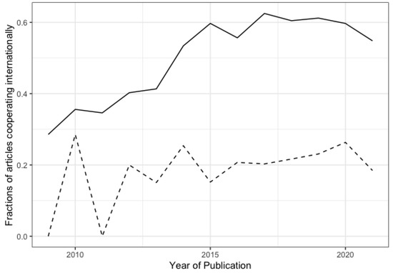
Figure 19.
Fraction of articles from the USA (solid line) and China (dashed line) published in Remote Sensing between 2009 and 2021 in cooperation with other countries.
The USA showed a much greater international connectivity than that of China. Overall, an increasing trend in international connectivity can be seen for both countries in Figure 19, but this trend has seemed to stagnate in the USA since about 2015 and declined in 2021 for both countries.
The effect of geo-political tensions on scientific publications can be seen more clearly when looking at papers with co-authors from the USA and China, as shown in Figure 20.
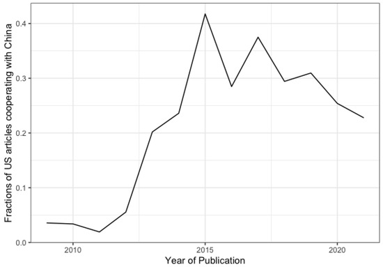
Figure 20.
Fraction of articles from the USA with co-authors from China published in Remote Sensing between 2009 and 2021.
The strong increase in the number of joint publications between China and the USA since 2011 came to a stop and showed a declining trend after 2015, as shown in Figure 20. This is a clear indication of an ongoing ‘scientific decoupling’ between the USA and China in remote sensing.
4. Discussion
Scientometrics allow decision-makers and other stakeholders to identify patterns and trends in science based on the analysis of scientific publications. By analyzing trends in keywords between 2009 and 2021 in papers published in Remote Sensing, an increase in the relative importance of SAR can be seen. A vital element of this increase is the broader availability of SAR data with the launch of Sentinel-1 and the open-data policy of the Sentinels, which is also reflected in the temporal increase in SAR publications after 2014 and in the high frequency with which Sentinel-1 itself occurs as a keyword in Remote Sensing. Similar increases were seen with the launch of COSMO-SkyMed and TerraSAR-X [34].
A key element of this increase is the accessibility of the data. Accessibility is crucial, and this is also the main reason for the substantial increase in the use of the Google Earth Engine, as it offers high accessibility not only in terms of data, but also in terms of ease of use. The widespread use of Landsat and MODIS data is due to the good accessibility to the data, and other sensors are only catching up. As shown by Zhao et al. [39], the lack of accessibility hinders the broader use of Chinese satellite data, leading to a relatively small number of papers. These results demonstrate the effectiveness of open-data policies [40] and the need to further improve ease of access, which is part of the success of the Google Earth Engine.
Major trends in papers published in Remote Sensing are deep learning and convolutional neural networks. With a significant fraction of papers now using these techniques, questioning this trend seems heretical.
However, do the results justify this tremendous increase, or are we witnessing another bubble in artificial intelligence [41]? At least in the author’s opinion, it is too early to say, but signs of herd mentality driving the trend are visible. Unfortunately, scientometric analyses further increase trends toward herd mentality in science. Especially if scientometrics are misused as a tool for personal evaluation, it can be beneficial for a researcher to follow trends, as scientific fields with a high number of publications lead, in general, to higher citation numbers. Furthermore, decision makers using scientometrics to decide on hot topics for additional financial support can also lead to a further concentration of research topics.
Artificial intelligence is a hot research topic, and not only in remote sensing. The importance that it is given exceeds the scientific and technological field and influences geo-political decisions. Technological anxieties are driving factors, although not the only factors, for deepening tensions between the USA and China. China has shown tremendous progress in scientific development [42], and remote sensing is a field in which China invests heavily. China’s interests in remote sensing are driven by its vast size and a desire for scientific and trustworthy data collection within a constant conflict between the center and the periphery.
Remote sensing is also related to security interests. With security applications and a tendency towards artificial intelligence, geo-political tensions also affect scientists in the field. Science is not conducted in a vacuum, and our ivory towers are situated in a world of rising tensions. The trend of decoupling [43,44,45] is visible in the results presented in this paper. The reduced cooperation between Chinese and US institutions indicates the influence of socioeconomic and political changes on scientific structures.
Political, socioeconomic, and environmental factors influence science and the selection of research topics. The analyses show this for topics over time and per country. Socioeconomic factors also influence the structure of scientific cooperation. The strongly centralized structure in China can be identified. Similarly, the structures of institutional co-authorship in the EU reflect problems in the integration of European research, as was already identified by Narin et al. [27].
The structure of institutional co-authorship in Africa is typical for scientific structures in the Global South. A weak interconnection between the African countries and increased connectivity to partners in the Global North can be seen, which can be interpreted as an indicator of neo-colonialism [46]. Due to the article processing charges [47], these structures might be more substantial in papers published in Remote Sensing. However, including co-authors from well-known institutions can also be used as a strategy to help in the review process [28], as well as a way to improve the use of English in a research paper to ensure publication of the results.
English is often identified as a barrier in scientific publishing [28,48]. This view is supported by statistical analyses—for example, that shown in Figure 21.
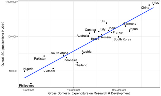
Figure 21.
Papers published in 2019 in relation to the gross domestic expenditure on research and development in 2019 for selected countries (sources: United Nations Statistics Division and the Web of Science).
Figure 21 shows the relation between research expenditure and research output in the form of publications. As we can see, many English-speaking countries are above the linear regression line and are, therefore, getting a higher return on investment, whereas many non-English-speaking countries are below the line. This is an indication of the advantages that English-speaking countries may have due to the use of English as a lingua franca in today’s science [29]. However, there are notable exceptions to the rule, such as China and Italy.
The analyses shown in this paper also do not support the notion of English as a major barrier to scientific publication in remote sensing. Taking readability as a proxy for English-language writing capabilities, no clear relationship between the number of publications and readability is visible. This indicates that the English language is not the main problem for publication success [49,50].
However, the assumption that the understandability of a paper is only a factor of the English language or even that a reading index can measure understandability is a strong simplification. A paper’s structure guiding the readers’ thoughts is similarly important. Unfortunately, structures of thoughts and logic are not uniform and differ within groups based on age, culture, language, etc. Language drives the thinking process and structure. Further scientific questions can be derived from this. Is the more significant number of equations in papers from China an expression of more mathematical thinking or of language problems that are overcome by mathematical expressions?
The analysis of the structure of scientific papers is, therefore, of great interest. The hypothesis is that different factors influence the structure of a paper. Three factors of interest are the influence of the author’s cultural and linguistic background, the discipline’s scientific culture, and the paper’s typology. Papers describing a new methodology may be differently structured from applications or case studies. This could lead to a further refinement of scientometric analyses.
From the analyses shown in this paper, structural differences in papers can be identified on a regional basis and based on the scientific sub-discipline. These results can be the basis for further analyses that can help answer questions on the relation between paper structure and the structure of the scientific environment.
Scientometrics are concerned with measuring science and analyzing structures in science. Structures of scientific papers can be an additional instrument in scientometric analyses. However, they have to be taken with care to avoid over-interpretation. Care should generally be taken for scientometric analyses, as they often tend to simplify, which is, for example, well discussed in the over-emphasis on using citations as a measurement for quality [51].
5. Conclusions
Scientometric analyses can provide insight into recent developments in specific scientific fields. By analyzing the full texts of 19,289 Remote Sensing articles downloaded from MDPI, ongoing trends are identified. An increase in the fraction of papers concerned with SAR sensors can be seen, as well as an increase in papers working on applications with ‘water’ and the ‘cryosphere’. On the other hand, a relative decrease in publications using optical and LiDAR remote sensing and applications in agriculture can be seen. This relative increase in SAR papers is in contrast to the findings of previous publications that saw the fraction of papers using radar sensors in the field of remote sensing to be relatively constant.
A detailed spatio-temporal analysis of institutional co-authorship revealed exciting patterns in the research structures of different regions, especially the centralized research structure in China. The ‘scientific decoupling’ between China and the USA is a worrisome trend that can clearly be identified from the analysis of international co-authorship.
Using the full-text analysis, a more detailed view of trends in structures and paper writing is possible. This allows for the identification of different styles for different countries and even cities and the identification of clear differences between sub-fields of remote sensing. Equation-heavy papers using hyperspectral sensors, long Methods sections in papers concerned with SAR, and longer Results sections for papers using optical remote sensing and UAVs are examples of the influence of the scientific sub-field on paper structures. Furthermore, the analysis of the readability of papers showed differences and a worrisome trend of decreased readability over time. Overall, using such a large set of full-text papers for scientometric analysis gives a deep insight into the field. Papers from Remote Sensing are only a subset of those in the remote sensing field, though. Certain biases in the analysis are, therefore, unavoidable. Further studies should include different journals.
Funding
This research received support from Wuhan University (WHU-GJZDZX-RC17).
Data Availability Statement
This study is based on articles published in Remote Sensing, which are open access.
Conflicts of Interest
The authors declare no conflict of interest.
References
- Bornmann, L.; Mutz, R. Growth rates of modern science: A bibliometric analysis based on the number of publications and cited references. J. Assoc. Inf. Sci. Technol. 2015, 66, 2215–2222. [Google Scholar] [CrossRef]
- Bornmann, L. Scientific peer review. Annu. Rev. Inf. Sci. Technol. 2011, 45, 197–245. [Google Scholar] [CrossRef]
- De Solla Price, D.J. Networks of Scientific Papers. Science 1965, 149, 510–515. [Google Scholar] [CrossRef]
- Ellegaard, O.; Wallin, J.A. The bibliometric analysis of scholarly production: How great is the impact? Scientometrics 2015, 105, 1809–1831. [Google Scholar] [CrossRef]
- Bar-Ilan, J. Informetrics at the beginning of the 21st century—A review. J. Inf. 2008, 2, 1–52. [Google Scholar] [CrossRef]
- Lin, W.Y.C. Research status and characteristics of library and information science in Taiwan: A bibliometric analysis. Scientometrics 2012, 92, 7–21. [Google Scholar] [CrossRef]
- Melin, G.; Persson, O. Studying research collaboration using co-authorships. Scientometrics 1996, 36, 363–377. [Google Scholar] [CrossRef]
- Romanelli, J.P.; Gonçalves, M.C.P.; de Abreu Pestana, L.F.; Soares, J.A.H.; Boschi, R.S.; Andrade, D.F. Four challenges when conducting bibliometric reviews and how to deal with them. Environ. Sci. Pollut. Res. 2021, 28, 60448–60458. [Google Scholar] [CrossRef]
- Romanelli, J.P.; Fujimoto, J.T.; Ferreira, M.D.; Milanez, D.H. Assessing ecological restoration as a research topic using bibliometric indicators. Ecol. Eng. 2018, 120, 311–320. [Google Scholar] [CrossRef]
- Harzing, A.W.; Alakangas, S. Google Scholar, Scopus and the Web of Science: A longitudinal and cross-disciplinary comparison. Scientometrics 2016, 106, 787–804. [Google Scholar] [CrossRef]
- Martín-Martín, A.; Orduna-Malea, E.; Thelwall, M.; Delgado López-Cózar, E. Google Scholar, Web of Science, and Scopus: A systematic comparison of citations in 252 subject categories. J. Inf. 2018, 12, 1160–1177. [Google Scholar] [CrossRef]
- Glenisson, P.; Glänzel, W.; Janssens, F.; De Moor, B. Combining full text and bibliometric information in mapping scientific disciplines. Inf. Process. Manag. 2005, 41, 1548–1572. [Google Scholar] [CrossRef]
- Song, M.; Kim, S.Y. Detecting the knowledge structure of bioinformatics by mining full-text collections. Scientometrics 2013, 96, 183–201. [Google Scholar] [CrossRef]
- Su, H.N.; Lee, P.C. Mapping knowledge structure by keyword co-occurrence: A first look at journal papers in Technology Foresight. Scientometrics 2010, 85, 65–79. [Google Scholar] [CrossRef]
- Van Raan, A.F.J. Fatal attraction: Conceptual and methodological problems in the ranking of universities by bibliometric methods. Scientometrics 2005, 62, 133–143. [Google Scholar] [CrossRef]
- Gorelick, N.; Hancher, M.; Dixon, M.; Ilyushchenko, S.; Thau, D.; Moore, R. Google Earth Engine: Planetary-scale geospatial analysis for everyone. Remote Sens. Environ. 2017, 202, 18–27. [Google Scholar] [CrossRef]
- Blaschke, T. Object based image analysis for remote sensing. ISPRS J. Photogramm. Remote Sens. 2010, 65, 2–16. [Google Scholar] [CrossRef]
- Friedl, M.A.; Sulla-Menashe, D.; Tan, B.; Schneider, A.; Ramankutty, N.; Sibley, A.; Huang, X. MODIS Collection 5 global land cover: Algorithm refinements and characterization of new datasets. Remote Sens. Environ. 2010, 114, 168–182. [Google Scholar] [CrossRef]
- Belgiu, M.; Drăguţ, L. Random forest in remote sensing: A review of applications and future directions. ISPRS J. Photogramm. Remote Sens. 2016, 114, 24–31. [Google Scholar] [CrossRef]
- Mountrakis, G.; Im, J.; Ogole, C. Support vector machines in remote sensing: A review. ISPRS J. Photogramm. Remote Sens. 2011, 66, 247–259. [Google Scholar] [CrossRef]
- Hu, F.; Xia, G.S.; Hu, J.; Zhang, L. Transferring Deep Convolutional Neural Networks for the Scene Classification of High-Resolution Remote Sensing Imagery. Remote Sens. 2015, 7, 14680–14707. [Google Scholar] [CrossRef]
- Pinzon, J.E.; Tucker, C.J. A Non-Stationary 1981–2012 AVHRR NDVI3g Time Series. Remote Sens. 2014, 6, 6929–6960. [Google Scholar] [CrossRef]
- Zhu, Z.; Bi, J.; Pan, Y.; Ganguly, S.; Anav, A.; Xu, L.; Samanta, A.; Piao, S.; Nemani, R.R.; Myneni, R.B. Global Data Sets of Vegetation Leaf Area Index (LAI)3g and Fraction of Photosynthetically Active Radiation (FPAR)3g Derived from Global Inventory Modeling and Mapping Studies (GIMMS) Normalized Difference Vegetation Index (NDVI3g) for the Period 1981 to 2011. Remote Sens. 2013, 5, 927–948. [Google Scholar] [CrossRef]
- Watts, A.C.; Ambrosia, V.G.; Hinkley, E.A. Unmanned Aircraft Systems in Remote Sensing and Scientific Research: Classification and Considerations of Use. Remote Sens. 2012, 4, 1671–1692. [Google Scholar] [CrossRef]
- Atzberger, C. Advances in Remote Sensing of Agriculture: Context Description, Existing Operational Monitoring Systems and Major Information Needs. Remote Sens. 2013, 5, 949–981. [Google Scholar] [CrossRef]
- McMahan, P.; McFarland, D.A. Creative Destruction: The Structural Consequences of Scientific Curation. Am. Sociol. Rev. 2021, 86, 341–376. [Google Scholar] [CrossRef]
- Narin, F.; Stevens, K.; Whitlow, E.S. Scientific co-operation in Europe and the citation of multinationally authored papers. Scientometrics 1991, 21, 313–323. [Google Scholar] [CrossRef]
- Ramírez-Castañeda, V. Disadvantages in preparing and publishing scientific papers caused by the dominance of the English language in science: The case of Colombian researchers in biological sciences. PLoS ONE 2020, 15, e0238372. [Google Scholar]
- Gordon, M.D. Scientific Babel. How Science Was Done before and after Global English; University of Chicago Press: Chicago, IL, USA, 2015. [Google Scholar]
- Honnibal, M.; Montani, I. spaCy 2: Natural language understanding with Bloom embeddings, convolutional neural networks and incremental parsing. Appear 2017, 7, 411–420. [Google Scholar]
- Flesh, R. A new readability yardstick. J. Appl. Psychol. 1948, 32, 221–233. [Google Scholar] [CrossRef]
- McClure, G.M. Readability formulas: Useful or useless? IEEE Trans. Prof. Commun. 1987, PC-30, 12–15. [Google Scholar] [CrossRef]
- Dale, E.; Chall, J.S. A Formula for Predicting Readability. Educ. Res. Bull. 1948, 27, 11–28. [Google Scholar]
- Liao, M.; Balz, T.; Rocca, F.; Li, D. Paradigm Changes in Surface-Motion Estimation From SAR: Lessons From 16 Years of Sino-European Cooperation in the Dragon Program. IEEE Geosci. Remote Sens. Mag. 2020, 8, 8–21. [Google Scholar] [CrossRef]
- Fingas, M. The Challenges of Remotely Measuring Oil Slick Thickness. Remote Sens. 2018, 10, 319. [Google Scholar] [CrossRef]
- Das, S.; Routray, A.; Deb, A.K. Fast Semi-Supervised Unmixing of Hyperspectral Image by Mutual Coherence Reduction and Recursive PCA. Remote Sens. 2018, 10, 1106. [Google Scholar] [CrossRef]
- Liu, C.; Ji, L.; Zhu, L.; Zhao, C. InSAR-Constrained Interseismic Deformation and Potential Seismogenic Asperities on the Altyn Tagh Fault at 91.5–95°E, Northern Tibetan Plateau. Remote Sens. 2018, 10, 943. [Google Scholar] [CrossRef]
- Merryman Boncori, J.P.; Langer Andersen, M.; Dall, J.; Kusk, A.; Kamstra, M.; Bech Andersen, S.; Bechor, N.; Bevan, S.; Bignami, C.; Gourmelen, N.; et al. Intercomparison and Validation of SAR-Based Ice Velocity Measurement Techniques within the Greenland Ice Sheet CCI Project. Remote Sens. 2018, 10, 929. [Google Scholar] [CrossRef]
- Zhao, Q.; Yu, L.; Du, Z.; Peng, D.; Hao, P.; Zhang, Y.; Gong, P. An Overview of the Applications of Earth Observation Satellite Data: Impacts and Future Trends. Remote Sens. 2022, 14, 1863. [Google Scholar] [CrossRef]
- Zuiderwijk, A.; Janssen, M. Open data policies, their implementation and impact: A framework for comparison. Gov. Inf. Q. 2014, 31, 17–29. [Google Scholar] [CrossRef]
- Ridley, M. How Innovation Works: Serendipity, Energy and the Saving of Time; Fourth Estate: Notting Hill, UK, 2020. [Google Scholar]
- Brainard, J.; Normile, D. China rises to first place in one key metric of research impact. Science 2022, 377, 799. [Google Scholar] [CrossRef]
- Lee, J. Decoupling the US Economy from China after COVID-19; Hudson Institute: Washington, DC, USA, 2020. [Google Scholar]
- Wyne, A. How to Think about Potentially Decoupling from China. Wash. Q. 2020, 43, 41–64. [Google Scholar] [CrossRef]
- Mervis, J. More Restrictive U.S. Policy on Chinese Graduate Student Visas Raises Alarm. Science. 2018. Available online: https://www.science.org/content/article/more-restrictive-us-policy-chinese-graduate-student-visas-raises-alarm (accessed on 20 July 2022).
- Majhanovich, S. English as a Tool of Neo-Colonialism and Globalization in Asian Contexts. In Critical Perspectives on International Education; Hébert, Y., Abdi, A.A., Eds.; Sense Publishers: Rotterdam, The Netherlands, 2013; pp. 249–261. [Google Scholar] [CrossRef]
- Solomon, D.J.; Björk, B.C. Publication fees in open access publishing: Sources of funding and factors influencing choice of journal. J. Am. Soc. Inf. Sci. Technol. 2012, 63, 98–107. [Google Scholar] [CrossRef]
- Hanauer, D.I.; Sheridan, C.L.; Englander, K. Linguistic Injustice in the Writing of Research Articles in English as a Second Language: Data From Taiwanese and Mexican Researchers. Writ. Commun. 2019, 36, 136–154. [Google Scholar] [CrossRef]
- Tardy, C. The role of English in scientific communication: Lingua franca or Tyrannosaurus rex? J. Engl. Acad. Purp. 2004, 3, 247–269. [Google Scholar] [CrossRef]
- Hyland, K. Academic publishing and the myth of linguistic injustice. J. Second Lang. Writ. 2016, 31, 58–69. [Google Scholar] [CrossRef]
- Aksnes, D.W.; Langfeldt, L.; Wouters, P. Citations, Citation Indicators, and Research Quality: An Overview of Basic Concepts and Theories. SAGE Open 2019, 9, 2158244019829575. [Google Scholar] [CrossRef] [Green Version]
Publisher’s Note: MDPI stays neutral with regard to jurisdictional claims in published maps and institutional affiliations. |
© 2022 by the author. Licensee MDPI, Basel, Switzerland. This article is an open access article distributed under the terms and conditions of the Creative Commons Attribution (CC BY) license (https://creativecommons.org/licenses/by/4.0/).