Article

No-Till Soil Organic Carbon Sequestration Patterns as Affected by Climate and Soil Erosion in the Arable Land of Mediterranean Europe

by
Giorgio Baiamonte
1,*,
Luciano Gristina
1,
Santo Orlando
1,
Salvatore Samuel Palermo
1 and
Mario Minacapilli
2
1
Department of Agricultural, Food and Forest Science (SAAF), University of Palermo, Viale delle Scienze, Bldg. 4, 90128 Palermo, Italy
2
Department of Engineering, University of Palermo, Viale delle Scienze, Bldg. 8, 90128 Palermo, Italy
*
Author to whom correspondence should be addressed.
Remote Sens. 2022, 14(16), 4064; https://doi.org/10.3390/rs14164064
Submission received: 14 July 2022 / Revised: 16 August 2022 / Accepted: 17 August 2022 / Published: 19 August 2022
(This article belongs to the Special Issue Remote Sensing for Soil Organic Carbon Mapping and Monitoring)

Abstract

:
No-tillage (NT) has been considered an agronomic tool to sequester soil organic carbon (SOC) and match the 4p1000 initiative requirements of conservative soil management. Recently, some doubts have emerged about the NT effect on SOC sequestration, often because observations and experimental data vary widely depending on climate and geographic characteristics. Therefore, a suitable SOC accounting method is needed that considers climate and morphology interactions. In this study, the yearly ratio between SOC in NT and conventional tillage (CT) (RRNT/CT) collected in a previous study for flat (96 samples) and sloping (44 samples) paired sites was used to map the overestimation of SOC sequestration. It was assumed that there would be an overestimation of NT capacity in sloping fields due to lower erosion processes with respect to CT. Towards this aim, Geographical Information System (GIS) techniques and an extensive input database of high spatial resolution maps were used in a simplified procedure to assess the overestimation of SOC stocks due to the sloping conditions and spatial variability of the Aridity Index (AI). Moreover, this also made it possible to quantify the effects of adopting NT practices on soil carbon sequestration compared to CT practices. The method was applied to the arable lands of five Mediterranean countries (France, Greece, Italy, Portugal and Spain) ranging between the 35° and 46° latitude. The results showed an overestimation of SOC sequestration, when the AI and soil erosion were considered. The average overestimation rate in the studied Mediterranean areas was 0.11 Mg ha−1 yr−1. Carbon stock overestimation ranged from 34 to 1417 Gg for Portugal and Italy, respectively. Even if overestimation is considered, 4p1000 goals are often reached, especially in the more arid areas. The findings of this research allowed us to map the areas suitable to meet the 4p1000 that could be achieved by adopting conservative practices such as NT.

Graphical Abstract

1. Introduction

At the 21st Conference of Parties (COP21) of the United Nations Framework Convention on Climate Change (UNFCCC), The Paris Agreement and the 4p1000 initiative (http://4p1000.org (accessed on 13 July 2022)) were proposed with the aim of increasing soil organic carbon (SOC) stocks through the adoption of agricultural best management practices (BMP). When adopting these BMP targets, an annual increase in the 4p1000 of SOC at the 0–40 cm soil depth must be achieved to contribute to climate change mitigation [1,2]. However, there has been some criticism and debate regarding the 4p1000 initiative. Some scholars have defined this initiative as idealistic [3,4], whereas other research has suggested that the goal is achievable under sustainable soil management techniques [5,6].
Importantly, no-tillage (NT) and, more generally, conservative soil management has been considered the most operative agronomic tool to sequester SOC and match the 4p1000 initiative requirements. In fact, during the past few years, a fair amount of experimental evidence has shown the potentiality of NT soil management to promote SOC sequestration. Results from extensive literature show that SOC sequestration under NT conditions widely varies with management practices and site characteristics [5,7]. West and Post [8] estimated a SOC sequestration potential of 0.57 Mg C ha−1 yr−1 for NT systems worldwide, and several studies on United States agriculture reported SOC sequestration values ranging from 0.40 to 0.45 Mg C ha−1 yr−1 and from −0.07 to 0.30 Mg C ha−1 yr−1 in the southern and the northern areas, respectively [9,10,11]. In European Mediterranean countries, it has been estimated that NT can increase SOC stock by 0.85 and 0.77 Mg ha−1 yr−1 in Spain and Italy, respectively [12], but lower values were estimated by Alvaro-Fuentes and Cantero-Martinez [13] that indicated a SOC increase of 0.23 Mg ha−1 yr−1 and by Aguilera et al. [14] of about 0.44 Mg ha−1 yr−1. In southern Italy, in a long-term trial spanning two decades, an average 0.13 Mg ha−1 yr−1 SOC sequestration was observed [15]. In contrast, Luo et al. [16] showed that the conversion from conventional tillage to NT significantly increased topsoil SOC (3.15 Mg C ha−1 at 0–10 cm) but did not enrich the total SOC stock in the whole soil profile.
The findings of surveys carried out by Poeplau and Don [17] showed a wide variability of SOC sequestration by NT from 4.94 Mg C ha−1 yr−1 to −11.0 Mg C ha−1 yr−1. The contribution of NT to SOC sequestration is determined by climate and, generally, a high NT ability in dry areas [18,19,20] is found due to the high relative carbon input production by NT [21]. Some doubts are emerging and, recently, various meta-analyses have shown that it is necessary to establish the role of NT in SOC sequestration, while also considering the climate and soil type that determine wide variability and site-specific responses [22,23,24,25,26]. These doubts are often justified by methodological constraints that lead to incorrect assessments of the carbon sequestration capacity attributable to NT land management, creating false expectations of NT as a mitigation tool [11,27]. These constraints are caused by a lack of bulk density measurements as well as by considering different soil layers. The commonly used “paired sites comparison” approach may relax those constrains, providing more suitable SOC accounting, especially when the relative ratio (RRNT/CT) between SOC in NT and SOC in CT is calculated [28,29].
The paired sites approach in the sloping areas affected by soil erosion certainly influences the SOC RRNT/CT because NT-managed land has a different soil carbon erosion control ability with respect to CT-managed land. Indeed, NT practices have a significant effect on soil erosion control due to the residues retained on the soil surface [30,31], limiting SOC redistribution and losses [32].
Little has been attempted to address this aspect as a cause of an overestimation of SOC sequestration, mainly when paired sites comparisons are carried out without baseline data [11,33]. Yang et al. [34] showed that the positive effect of CT on SOC was only reliable in severely eroded soils or steeply sloping farmland, and it was not evident in flat areas.
Recently, in a specific extensive paired sites long-term survey, Novara et al. [7] demonstrated the important influence of slope [35] and the AI [19] on the SOC RRNT/CT evaluation in durum wheat within the Mediterranean climatic belt. Specifically, the average yearly SOC RRNT/CT was 0.008 in 140 paired sites, ranging between 0.0061 and 0.012 for flat and sloping conditions, respectively. It was hypothesized that a paired sites comparison would result in an overestimation of NT capacity in sloping areas due to losses by erosion processes. Because of the influence of climate on the SOC RRNT/CT, a large-scale spatial analysis of the AI could be useful in detecting the feasibility of the national 4p1000 initiatives.
Freely available remote sensing data from satellite sensors with large spatial coverage have become available in the last decades, and they can be used to determine advantages over the large-scale mapping with flexibility, efficiency, and low operating cost. A recent Remote Sensing Special Issue “CORINE Land Cover System: Limits and Challenges for Territorial Studies and Planning” interestingly focused on the limitations and possible solutions related to the use of CORINE data. Thanks to these tools, we addressed the objectives of this work that can be summarized as follows:
  • Detecting the feasibility of achieving 4p1000 targets in European Mediterranean arable land, considering the effects of climate and slope on the spatial SOC RRNT/CT computation;
  • Calculating and mapping the overestimation of SOC sequestration due to soil erosion processes;
  • Investigating NT practices’ actual ability to match the 4p1000 goal.

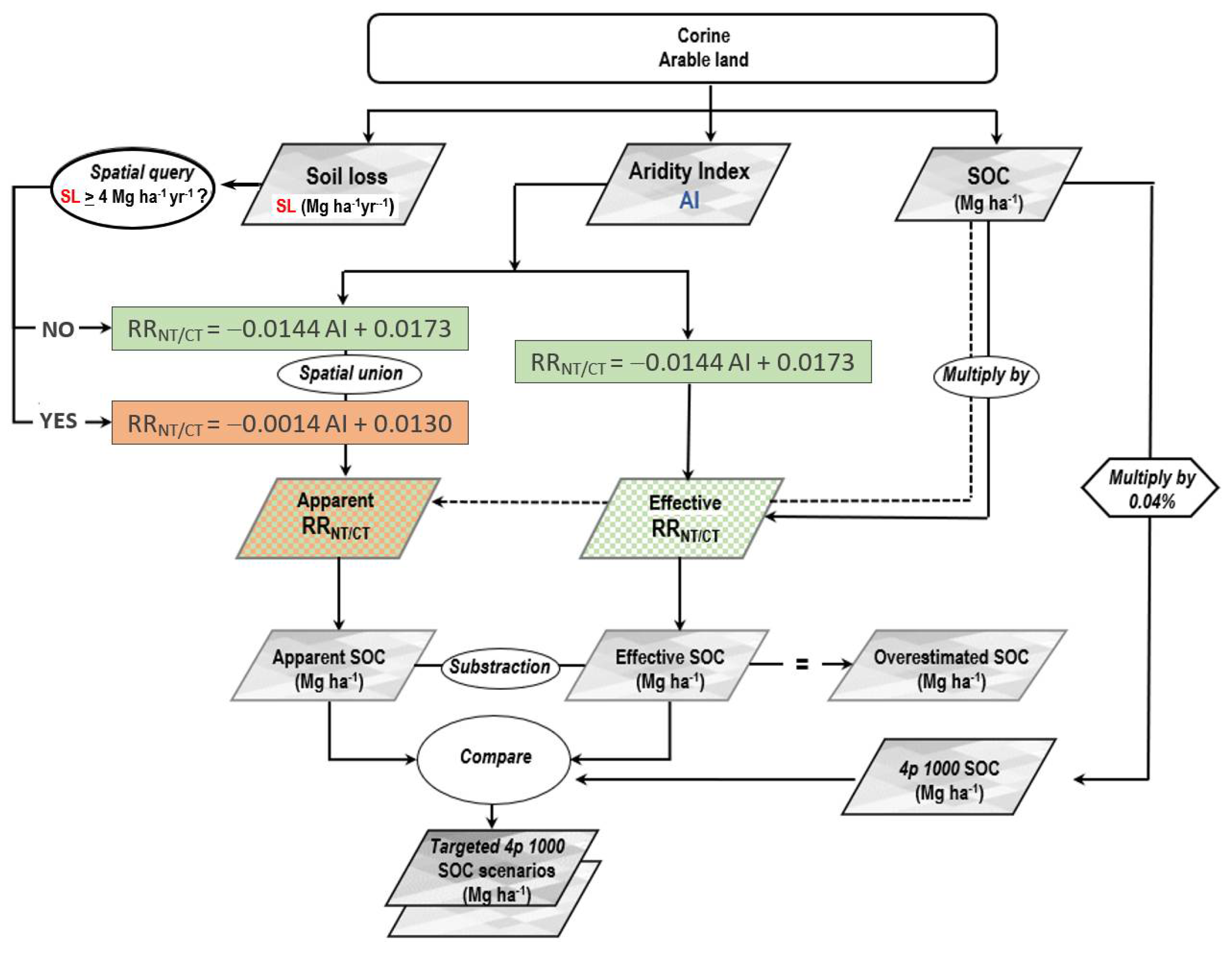
2. Materials and Methods

The analysis was performed for Mediterranean arable lands, including five countries (France, Greece, Italy, Portugal and Spain), all overlooking the Mediterranean Sea, located at latitudes between 35–46° and characterized by a very different morphology and climate, and where durum wheat is mostly cultivated.
In flat areas (FA) with no erosion risk, the SOC relative ratio (RRNT/CT) only depends on the carbon input (C) and on the soil’s ability to stabilize biomass inputs. Therefore, the SOC relative ratio (RRNT/CT) is a valuable indicator of the effective SOC sequestration under NT with respect to CT. RRNT/CT values higher than zero indicate that NT has sequestered more C through biomass inputs than CT or that over time NT has decreased the mineralization rate of the organic matter, reducing SOC stock losses in comparison to CT.
In sloping areas (SA), SOC sequestration explained by the RRNT/CT values must be considered an apparent sequestration because NT SOC sequestration is overestimated due to the higher C erosion with CT than with NT. Conceptually, in areas characterized by similar climate conditions, C sequestration/depletion can be considered almost equal in FA and SA; consequently, the differences between apparent and effective C sequestration/depletion can be attributed to C erosion reduction in NT, according to the following relationship:
apparent SOC sequestration = effective SOC sequestration + SOC losses by erosion
where the apparent SOC sequestration is the RRNT/CT in SA, the effective SOC sequestration/depletion is the RRNT/CT in FA and C losses by erosion is the specific contribution of the erosion processes on RRNT/CT dependent on the differences in SOC erosion control ability by NT and CT (estimated at 1:4 by Panagos et al. [36]). Of course, in FA where no erosion processes occur, apparent SOC sequestration is equal to effective SOC sequestration.
Using 140 paired sites, located at latitudes between 35° and 45°, almost matching the latitude range investigated in the present work, Novara et al. [7] studied the relationship between the RRNT/CT and Aridity Index (AI) independently for sloping areas (SA) and flat areas (FA), showing different behaviour according to topographic conditions. In particular, Novara et al. [7] derived the following linear regressions:
RR   NT / CT = 0.0144   AI + 0.0173   for   FA
RR   NT / CT = 0.0014   AI + 0.0130   for   SA
where RRNT/CT indicates the yearly relative ratio between SOC in NT and CT, whereas the AI [37] is a climatic variable able to explain the relative ratio (RR NT/CT) of crop productivity and SOC sequestration under NT management [7,21,38].
Equations (2) and (3) were derived at a local scale through data from 140 paired sites. In this paper, before upscaling them to the investigated area for the two equations, an ANOVA was carried out. The analysis was performed for FA (Table 1) to determine whether the explanatory variable (AI) contributes significant information (null hypothesis H0) to Equation (2) and to know whether Equation (2) is valid to provide the mean to describe the whole population, or if the information brought by the AI is of value or not.
Given the fact that the probability corresponding to the F value is lower than 0.001, we would be taking a lower than 0.1% risk in assuming that the null hypothesis (no effect of the AI) is wrong. Therefore, we can conclude with confidence that the AI does contribute a significant amount of information in explaining the RRNT/CT. Statistical parameters (Table 2), show that the 95% confidence range of the AI parameter and the one for the intercept are very narrow.
For FA, Figure 1 shows the data together with the regression line, the prediction band (black lines) and the confidence interval (dotted lines) on its mean for a given AI value. Figure 1 clearly shows that there is a linear trend, although variability around the line occurs, and that the 3 observations that are outside the [−1.96, 1.96] interval (the value of the 97.5 percentile point of the standard normal distribution) are outside the second confidence interval as well. An analysis of variance was not performed for the sloping areas, since the regression line is almost horizontal (very low angular coefficient −0.0014, F = 0.033).
Considering that the SA regression line lies outside of the of the FA confidence region, we can conclude that the two datasets (FA and SA) belong to different populations and can be separately analysed, and the differences between the two regression lines can be attributed to the soil erosion processes.
The methodological framework is summarized in the flowchart of Figure 2 where input and output data flow are reported. For the apparent RRNT/CT determination, a spatial query according to an erosion threshold (discussed later) made it possible to identify FA and SA areas where Equation (2) or Equation (3) were applied, respectively. The apparent and the effective SOC sequestration (Mg ha−1) were calculated by multiplying the RRs maps for the SOC map obtained by Lugato et al. [39] and compared to 4p1000 SOC (Mg ha−1).
The input data used in this paper were obtained from different geographical databases developed to support the scientific community and to focus on the arable lands of Mediterranean countries (France, Greece, Italy, Portugal and Spain), which are where annual cereals can potentially be cultivated.
The Copernicus Global Land Service (CGLS) CORINE land use map of the European 182 Community was used to obtain the spatial distribution of arable land in the study area [40]. The CGLS inventory was initiated in 1990 and updates have been produced in 2000, 2006, 2012 and 2018. It consists of an inventory of land cover in 44 classes. CLC uses a Minimum Mapping Unit (MMU) of 25 hectares (ha) for areal phenomena and a minimum width of 100 m for linear phenomena. The CLC is produced by the visual interpretation of high-resolution satellite imagery combined with semi-automatic satellite image processing as well as GIS integration. In our study we used the 2018 version of CGLS that was the first version based on Sentinel-2 and Landsat-8 satellite image products with an MMU of 100 m. In particular, the 211 class CORINE legend was chosen to identify arable land with a resolution of 100 m × 100 m. The climate database for Europe (ClimateEU) was used to map two key meteorological variables [41]: yearly rainfall, Ra, yearly reference evapotranspiration and ET0 [37]. Both were retrieved using a 1 km × 1 km spatial resolution. The European Soil Database (ESDAC) has been used as a source of high spatial resolution (100 m × 100 m) of soil erosion rates and SOC stocks of agricultural soils. In particular, the European Soil erosion map produced by Panagos et al. [36] was used to identify erosive and non-erosive areas, whereas the European SOC stock map of agricultural soils developed by Lugato et al. [39] was used to estimate the 4p1000 target and effective and apparent SOC sequestration as well as possible overestimations [30,31]. A threshold value of 1.4 Mg ha−1 yr−1 was chosen to discriminate the erosive areas (values higher than 1.4 Mg ha−1 yr−1) as sloping areas and flat areas (values lower than 1.4 Mg ha−1 yr−1). The threshold value of 1.4 Mg ha−1 yr−1 was determined in relation to tolerable soil erosion, as suggested by Verheijen et al. [42].
Considering that the SOC stock values obtained by Lugato et al. [39] refer to the 0–30 cm depth, whereas the 4p1000 strategy refers to a 0–40 cm depth, in this study the SOC stock data obtained by Lugato et al. [39] were adjusted according to Poulton et al.’s [3] suggestion for most of the topsoil data to give an increase of 5%. The input data was managed using standard Geographical Information System (GIS) techniques. Specifically, the data were stored in a raster format (geotiff) and were projected in a unique geographical system (ETRS89 Lambert Azimuthal Equal Area). In this way, raster map-algebra techniques were used to overlap all raster data and to calculate outputs following the flowchart of Figure 2.

3. Results

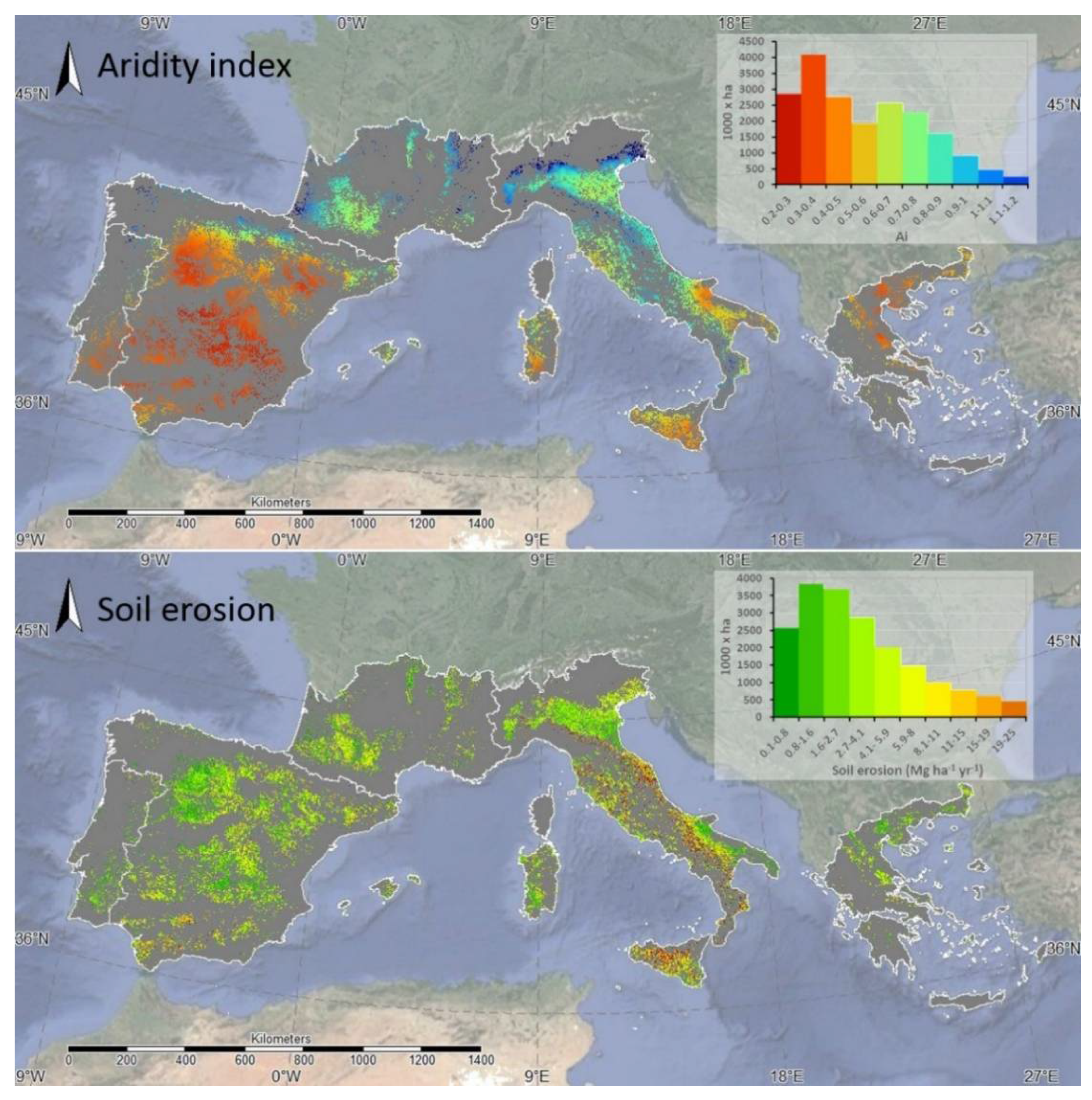
3.1. Climate and Soil Erosion

In the studied area, the climate described in terms of the Aridity Index (AI) shows an average value of 0.57 (from 0.2 to 1.2), with significant differences among the studied countries, ranging from 0.43 to 0.82 for Greece and France, respectively. Considerable uniformity was found for Spain, Portugal, France and Greece; in contrast, Italy showed significant AI differences from the north to the south and the largest standard deviation (Table 3, Figure 3).
The average value of soil erosion in the study area was 3.9 Mg ha−1 yr−1 (from 0.1 to 19.1 Mg ha−1 yr−1) and ranged from 2.20 Mg ha−1 yr−1 in Portugal to 7.18 Mg ha−1 yr−1 in Italy, where the highest variability was observed (Table 3, Figure 3).

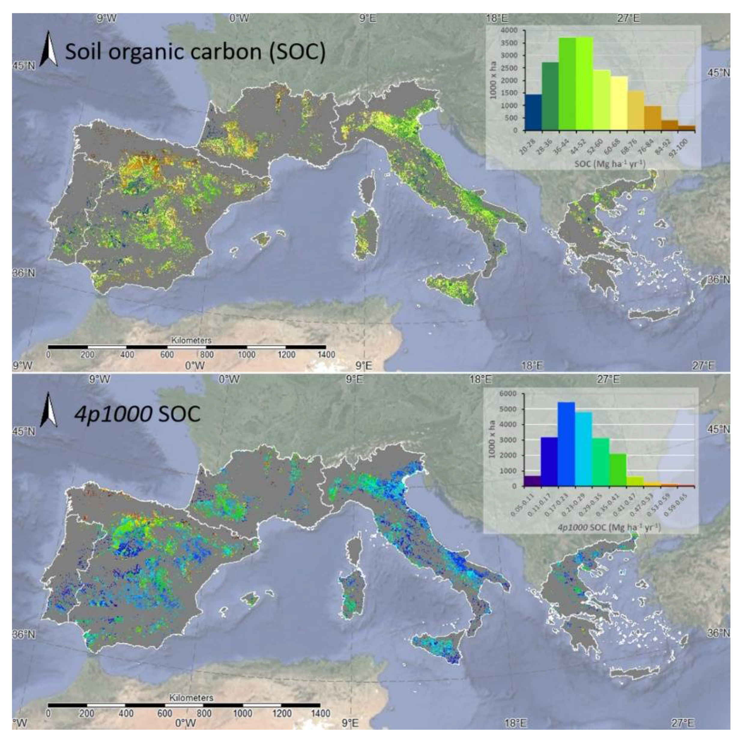
3.2. Soil Organic Carbon in Arable Land and the 4p1000 Target

In European Mediterranean countries, the potential areas for NT management cover a total of 21,917 (ha × 1000) (Table 4).
The SOC map analysis indicates that the soil of the arable land in the Mediterranean areas considered in this study store close to 1,110,120 Gg of C in the upper 40 cm (Figure 4), ranging between 20 and 100 Mg ha−1. The highest SOC values were recorded in France, followed by Spain, Greece, Italy and Portugal, with an average ranging from 59.9 Mg ha−1 to 38.2 Mg ha−1. Due to the large arable land area, Spain stores about 532,633 Gg of SOC. Only 25,307 Gg of SOC is stored in Portugal (Table 4).
Based on this estimation of total SOC stocks, 5552 Gg of SOC (0.24 Mg ha−1) per year should be sequestered in the arable land soils of the studied areas to achieve the 4p1000 goal (Table 4). In relation to the NT potential area, 2662 Gg are needed for Spain and only 127 Gg for Portugal. The SOC sequestration rate to achieve the 4p1000 goal is higher for France and Spain (0.30 and 0.27 Mg ha−1 yr−1) and lower for Italy and Portugal (0.22 and 0.19 Mg ha−1 yr−1, respectively).
Figure 4 shows that the SOC sequestration needed to achieve 4p1000 lies in a range from 0.05 to 0.65 Mg ha−1 yr−1, and that it is strongly influenced by SOC stocks and is also correlated with the AI trend from the north to the south.

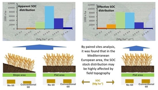
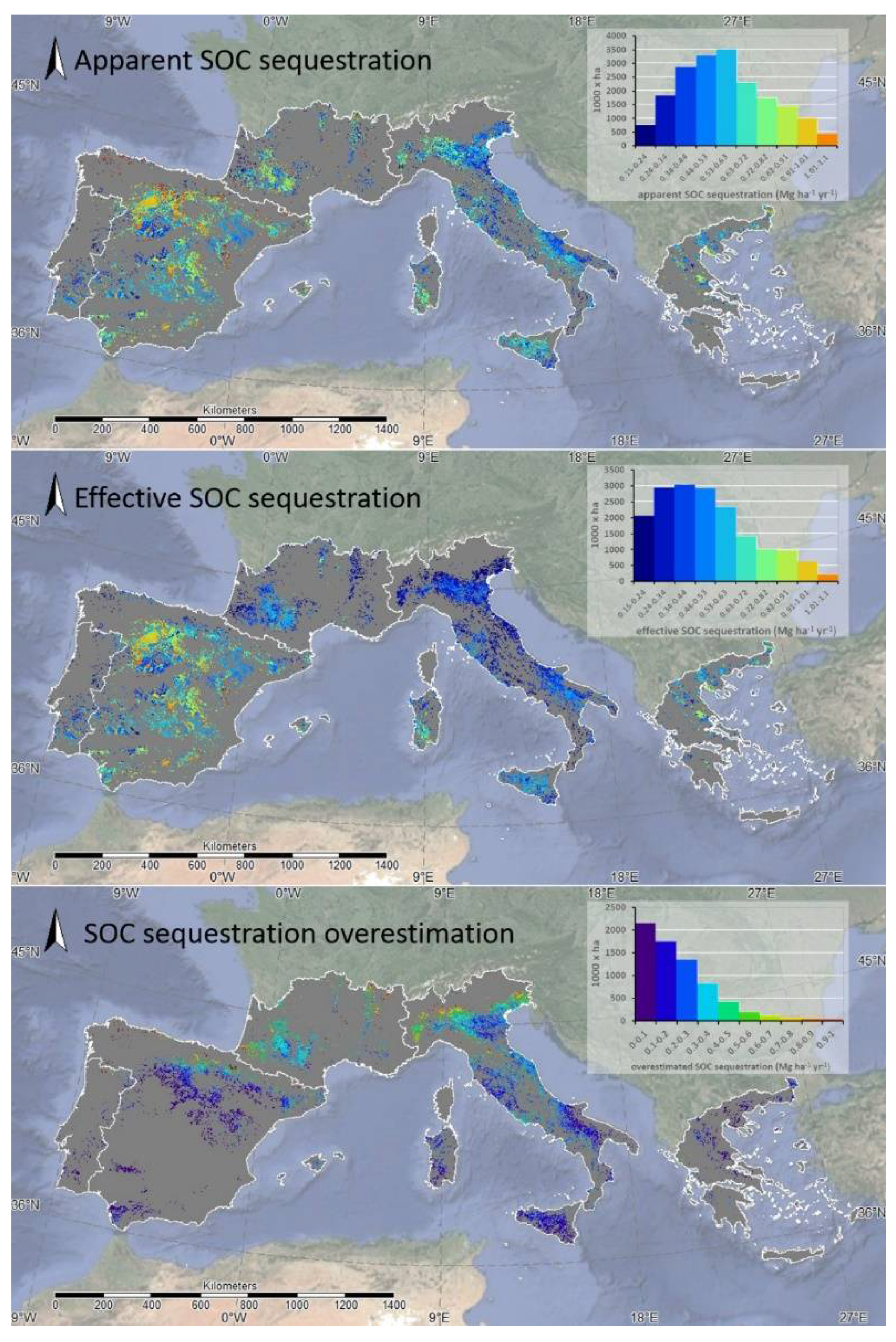
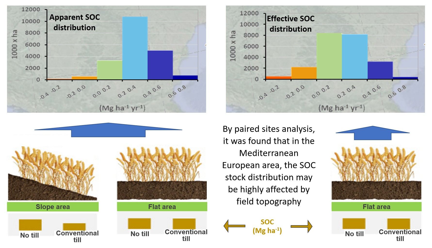
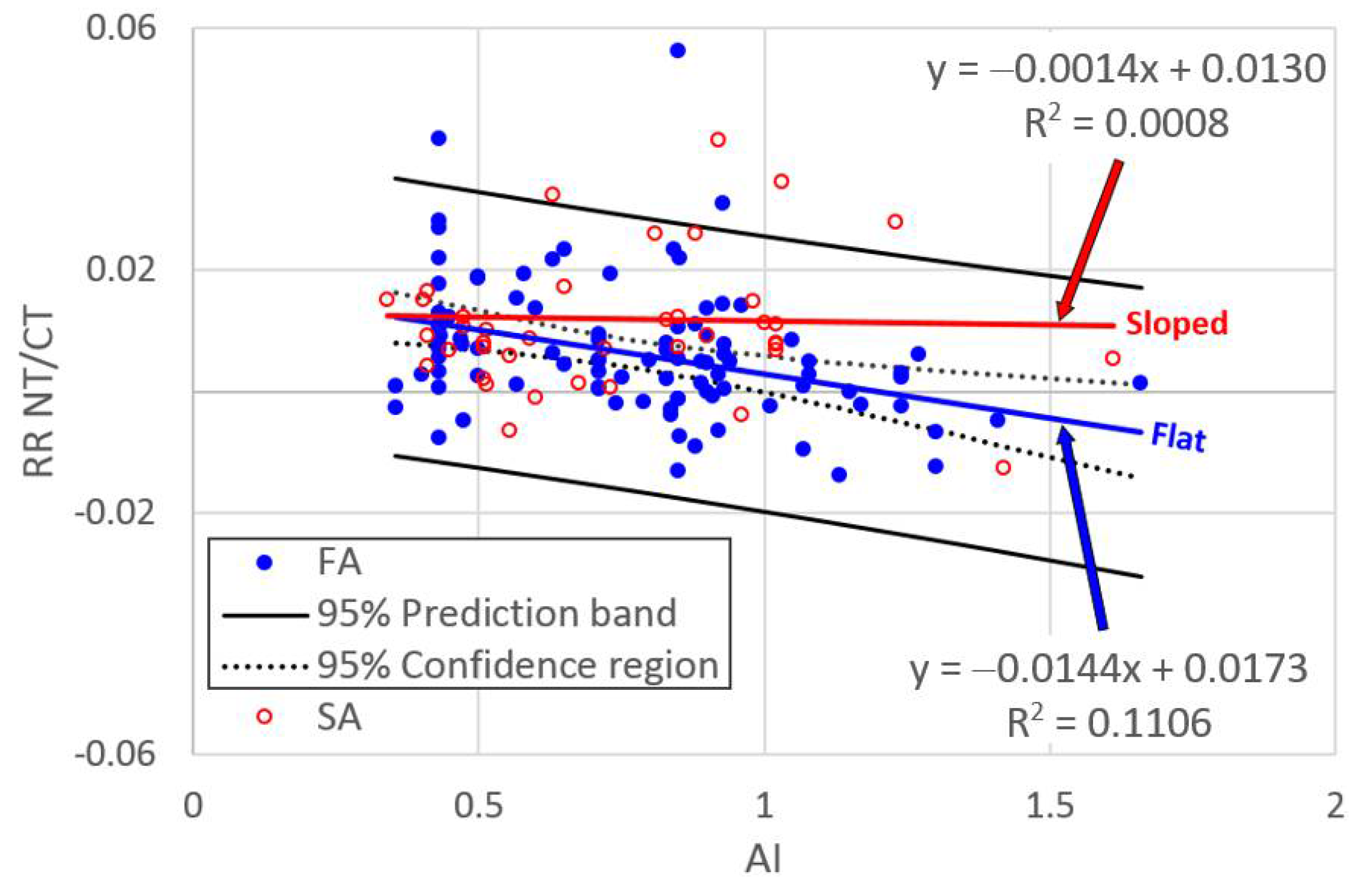
3.3. Apparent, Effective SOC Sequestration and Overestimation, in the Mediterranean Arable Land

According to the flowchart reported in Figure 2, to estimate the apparent and effective SOC sequestration, Equations (2) and (3) were applied in a spatially distributed way over flat areas (no erosion processes) and sloping areas (erosion processes), respectively. As reported in Table 5, 12,585 Gg resulted in the apparent potential SOC sequestration through NT practices, with a total of 4443 Gg representing the SOC overestimation (Table 5). The different Mediterranean areas showed a variable overestimation, because of the interaction between the slope and AI effects but also due to the original SOC stock, ranging from 34 to 1417 Gg for Portugal and Italy, respectively.
The average overestimation rate was 0.11 Mg ha−1 yr−1, with a large variability among the studied Mediterranean areas (Table 5). The distributions of the apparent and effective SOC sequestration rates (Figure 5) showed the effect of the interactions between the AI and slope in determining the SOC sequestration overestimation. The lowest values of SOC overestimation arose in the most arid areas, such as Sicily, despite evident soil erosion processes, and in central Spain and Greece. The ratio between the apparent and effective SOC sequestration (A/E) was 1.33 on average but was strongly variable among the Mediterranean areas, only 1.08 and 1.09 for Spain and Greece, and up to 1.62 and 1.73 for Italy and France, respectively (Table 5).

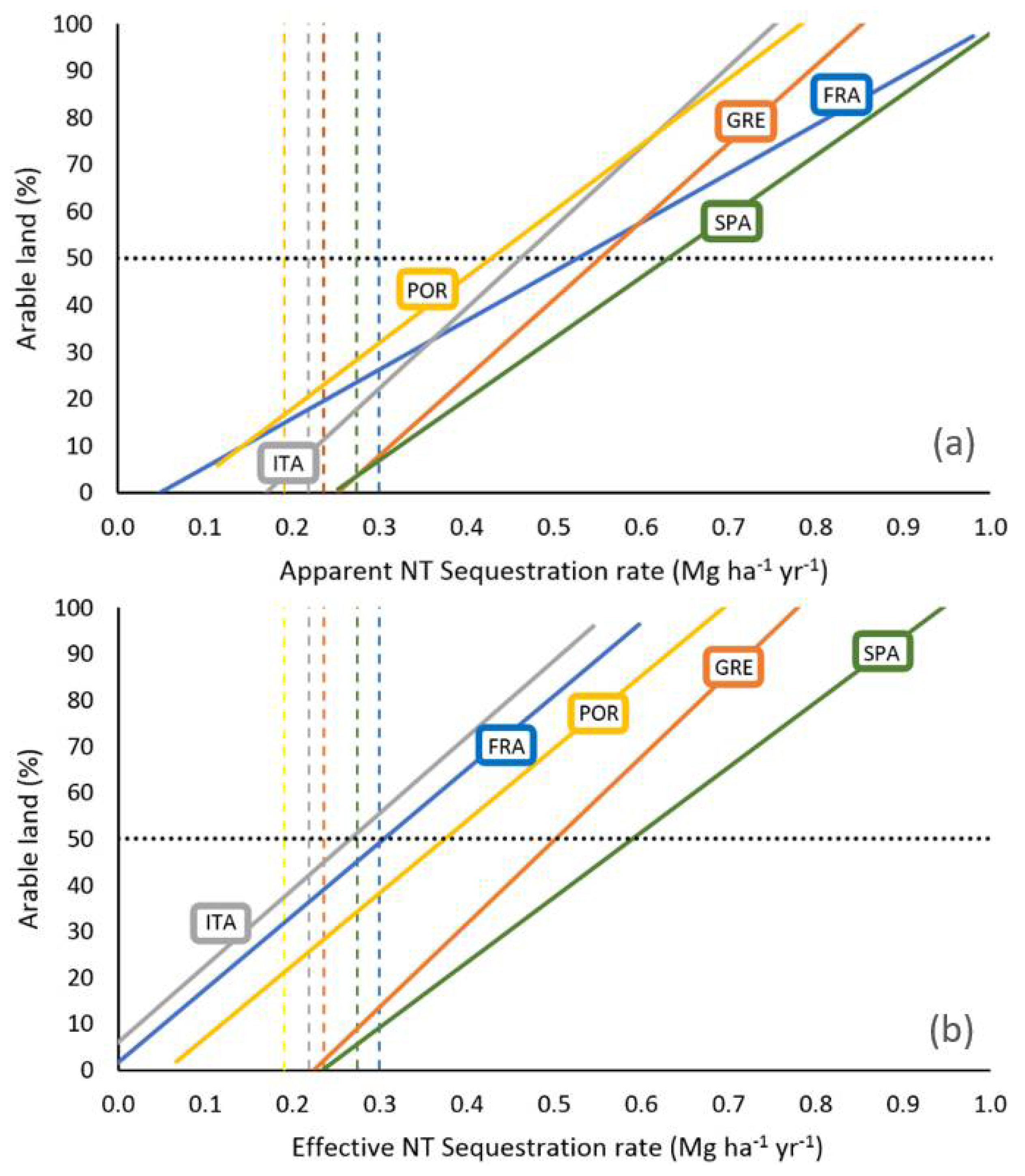
3.4. Matching the 4p1000 Goal

The percentage of arable land area (%) in which NT management introduction can meet 4p1000 goals is shown in Figure 6 separately for the apparent (Figure 6a) and effective SOC sequestration rates (Figure 6b). The percentage of the arable land area and the relative NT SOC sequestration capacity make it possible to identify the percentage of arable lands suitable to match the 4p1000 initiative through NT introduction.
In each country, the SOC sequestration rate varied widely from apparent to effective. When apparent SOC sequestration is considered, the average values ranged from 0.45 to 0.65 in Portugal and Spain, respectively. Considering the effective SOC sequestration, a larger interval was found (0.25 and 0.55 in Italy and Spain, respectively) (Figure 6).
Changes in SOC sequestration from apparent to effective are related to the areas considered and mainly depend on the AI variability and arable land morphology. In Spain and Greece, where the lowest AI values are present, areas not able to reach the 4p1000 threshold are very low for both apparent and effective SOC sequestration (Figure 6). For the other countries, the percentage of arable land not suitable to match the 4p1000 ranged between 9% and 27% when the apparent SOC sequestration rate is considered and from 22% to 50% when the effective SOC sequestration is considered.
For both apparent and effective SOC sequestration, the distribution of the potential 4p1000 matching areas was elaborated as the difference between the SOC sequestration rate and the 4p1000 SOC map. No differences were found between the apparent and effective SOC sequestration rate in Spain and Greece (Figure 7a,b). More consistent differences were found for all of the other countries, mainly in the more arid parts of Italy (islands and southern Italy).

4. Discussion

The objective of this study was to suggest a reliable estimate of SOC sequestration attributable to the application of NT management practices in relation to (i) the high variability of climate in European Mediterranean regions and (ii) the evident effect of soil erosion on SOC losses.
Using spatialized input data (raster maps) and two simplified relationships derived from an extensive survey, the proposed approach made it possible to obtain a set of output maps of SOC sequestration under NT driven by two spatial input factors (AI and soil erosion).
The European Conservation Agriculture Federation (ECAF) reported that SOC sequestered by the application of NT management practices would easily reach the set targets by 2030 [12]. This analysis considers the sequestration rate under NT very homogeneous among the considered countries except for France, around 0.8 Mg ha−1 yr−1.
The ECAF data show a very high potential to match 4p1000 targets by NT, but this result should be viewed critically since its analysis is based on a single long-term experiment that generally leads to uncorrected estimates (overestimation) of NT SOC sequestration when applied to larger areas.
For Spain, Portugal, Italy and Greece, the average sequestration rates under NT, showed in the ECAF report, were higher than those estimated in this study, both in the case of apparent and effective rates (0.54 and 0.43 Mg ha−1 yr−1, respectively). A mere 0.20 Mg ha−1 yr−1 is reported for France, but this rate probably comes from Atlantic trials and is not appropriate for Mediterranean areas. In Spain, where several studies have been carried out in different areas, Gonzales-Sanchez et al. [43] found an average SOC sequestration by NT equal to 0.72 Mg ha−1 yr−1 but observed a large variability between 0.09 and 2.01 Mg ha−1 yr−1 in relation to climate. Furthermore, by upscaling the same data to study the effect of NT applications on SOC, Moreno-García et al. [44] found an average SOC sequestration of 0.43 Mg ha−1 yr−1 and an almost similar variability.
The spatial approach proposed in this study made it possible to determine a value of 0.6 Mg ha−1 yr−1 (on average for all of Spain) in between the range 0.43 and 0.72 Mg ha−1 yr−1. Furthermore, 0.41 Mg ha−1 yr−1 and 0.34 Mg ha−1 yr−1 were estimated using data retrieved from Moreno-Garcia et al. [44], for apparent and effective SOC sequestration, respectively, by also applying the approach developed in this study.
This paper’s analysis showed lower SOC sequestration than that proposed by González-Sánchez [43], but in any case, the latter suggests that there is a greater potential for the 4p1000 initiative, even if effective SOC sequestration is considered, especially when and where agricultural intensification and climatic conditions (low AI) have determined a reduction in carbon stock content.
In fact, the SOC content generally depends on climatic and edaphic conditions, but also on agricultural management [45,46]. Moreover, the introduction of conservative agricultural practices is very powerful when soils have been subjected to long-term stress, such as deep plowing, inversion and frequent tillage [44]. Determining the separate influences of two driving factors, the AI and the role of soil erosion processes, on SOC overestimation allows for the determination of a more accurate and site-specific response of NT.
In conclusion, the need to adopt different agro-environment policies in relation to different contexts to support and improve the spread and farmers’ acceptance of NT should be advisable. A diversified policy approach should also consider economic and competitive aspects as well as environmental benefits of NT. For the farmers, benefits would lay in incentives, whereas the environmental benefits would have to be considered site by site.

5. Conclusions

This paper presents a spatial approach to verify the opportunity of NT to match the national objectives of SOC sequestration in relation to the 4p1000 goal. Specifically, the potential effect of the application of NT on cereal crops has been studied in European Mediterranean areas, also considering the overestimation, which may determine errors in SOC accounting, such as that determined by soil erosion processes. The suggested approach made it possible to identify the potential of applying NT practices to meet the 4p1000 initiative by introducing the idea of apparent SOC sequestration, driven by soil erosion processes, and an effective NT sequestration ability.
The analysis showed that arable land has considerable potential to increase SOC storage rates above the 4p1000 target in the Mediterranean climate, also due to the relatively low SOC stock levels. The results demonstrated that NT management could increase SOC stocks, often at rates higher than 4p1000 per year (in the 0–40 cm depth), but its effectiveness is strongly site-specific despite the proven overestimation. Of course, any contribution to mitigating climate change is welcome, if considering that even a small increase in SOC has a large impact on several physical properties of soil [3], and any initiative aimed at increasing SOC, such as the 4p1000, should be promoted [2]. In this context, we believe that the proposed methodology can be considered an example of an initiative that can provide an opportunity to link policy and research interests, connecting potential soil carbon storage and the need to improve the adoption of sequestration measures at large scales as suggested by Pozza and Field [47].
In fact, adopting NT management practices in areas subjected to erosion will reduce soil loss due to the protection of the soil surface and will maintain productivity and SOC when compared to areas under conventional tillage. In any case, the adoption of NT on erodible sites may positively affect food security as well reduce other negative effects of erosion on SOC storage across landscapes, even if particular attention must be paid to correct SOC accountability [19].
Considering the interest for the 4p1000 initiative in the European Mediterranean areas, it is essential to encourage NT management as an alternative to CT to increase SOC sequestration and contribute to climate change mitigation by using incentive payments as well as other means.
Given the importance of NT for environmental sustainability, economic incentives must be adopted to support this management strategy. For these reasons, the proposed approach can be considered as a helpful decision tool for farmers and policymakers to target incentives in relation to the effective ability to sequester atmospheric CO2 or SOC loss reduction by NT.
In the same way, support granted to farmers to shift from conventional to conservation agriculture provided in Italy by agri-environmental climate compensation payments, to be more effective, should consider a more reliable SOC sequestration account under shifting soil management techniques while also supporting cooperation for innovation.
This study shows the need to adopt different agro-environment policies in relation to different contexts to support and improve the spread and farmers’ acceptance of NT. A diversified policy approach must also consider economic and competitive aspects as well as the environmental benefits of NT according to the second pillar of the common agricultural policy.
Finally, it should be noted that the study performed here is of course affected by uncertainties that lay in the large-scale applications of the literature dataset that was considered to derive the study maps.

Author Contributions

Conceptualization, G.B., L.G. and M.M.; methodology, G.B., L.G. and M.M.; software, G.B., L.G. and M.M.; validation, G.B., L.G. and M.M.; formal analysis, S.O., S.S.P. and M.M.; investigation, G.B., L.G. and M.M.; resources, G.B., L.G. and M.M.; data curation, M.M.; writing—original draft preparation, G.B., L.G. and M.M.; writing—review and editing, G.B., L.G., S.O., S.S.P. and M.M.; visualization, G.B. and M.M.; supervision, G.B., L.G. and M.M. All authors have read and agreed to the published version of the manuscript.

Funding

This research received no external funding.

Data Availability Statement

The data presented in this study are available upon request from the corresponding author.

Acknowledgments

The authors wish to thank the anonymous reviewers for their helpful comments and their careful reading of the manuscript during the revision stage.

Conflicts of Interest

The authors declare no conflict of interest.

References

  1. Demenois, J.; Torquebiau, E.; Arnoult, M.H.; Eglin, T.; Masse, D.; Assouma, M.H.; Blanfort, V.; Chenu, C.; Chapuis-Lardy, L.; Medoc, J.M.; et al. Barriers and Strategies to Boost Soil Carbon Sequestration in Agriculture. Front. Sustain. Food Syst. 2020, 4, 37. [Google Scholar] [CrossRef]
  2. Rumpel, C.; Amiraslani, F.; Chenu, C.; Cardenas, M.G.; Kaonga, M.; Koutika, L.S.; Ladha, J.; Madari, B.; Shirato, Y.; Smith, P.; et al. The 4p1000 initiative: Opportunities, limitations and challenges for implementing soil organic carbon sequestration as a sustainable development strategy. Ambio 2020, 49, 350–360. [Google Scholar] [CrossRef]
  3. Poulton, P.; Johnston, J.; Macdonald, A.; White, R.; Powlson, D. Major limitations to achieving “4 per 1000” increases in soil organic carbon stock in temperate regions: Evidence from long-term experiments at Rothamsted Research, United Kingdom. Glob. Change Biol. 2018, 24, 2563–2584. [Google Scholar] [CrossRef] [PubMed]
  4. Van Groenigen, K.J.; Osenberg, C.W.; Terrer, C.; Carrillo, Y.; Dijkstra, F.A.; Heath, J.; Nie, M.; Pendall, E.; Phillips, R.P.; Hungate, B.A. Faster turnover of new soil carbon inputs under increased atmospheric CO2. Glob. Change Biol. 2017, 23, 4420–4429. [Google Scholar] [CrossRef]
  5. Francaviglia, R.; Di Bene, C.; Farina, R.; Salvati, L.; Vicente-Vicente, J.L. Assessing “4 per 1000” soil organic carbon storage rates under Mediterranean climate: A comprehensive data analysis. Mitig. Adapt. Strateg. Glob. Change 2019, 24, 795–818. [Google Scholar] [CrossRef]
  6. Valkama, E.; Kunypiyaeva, G.; Zhapayev, R.; Karabayev, M.; Zhusupbekov, E.; Perego, A.; Schillaci, C.; Sacco, D.; Moretti, B.; Grignani, C.; et al. Can conservation agriculture increase soil carbon sequestration? A modelling approach. Geoderma 2020, 369, 114298. [Google Scholar] [CrossRef]
  7. Novara, A.; Sarno, M.; Gristina, L. No till soil organic carbon sequestration could be overestimated when slope effect is not considered. Sci. Total Environ. 2021, 757, 143758. [Google Scholar] [CrossRef]
  8. West, T.O.; Post, W.M. Soil Organic Carbon Sequestration Rates by Tillage and Crop Rotation. Soil Sci. Soc. Am. J. 2002, 66, 1930–1946. [Google Scholar] [CrossRef]
  9. Doraiswamy, P.C.; McCarty, G.W.; Hunt, E.R.; Yost, R.S.; Doumbia, M.; Franzluebbers, A.J. Modeling soil carbon sequestration in agricultural lands of Mali. Agric. Syst. 2007, 94, 63–74. [Google Scholar] [CrossRef]
  10. Franzluebbers, A.J.; Causarano, H.J.; Norfleet, M.L. Soil conditioning index and soil organic carbon in the Midwest and Southeastern United States. J. Soil Water Conserv. 2011, 66, 178–182. [Google Scholar] [CrossRef]
  11. Olson, K.R. Impacts of tillage, slope, and erosion on soil organic carbon retention. Soil Sci. 2010, 175, 562–567. [Google Scholar] [CrossRef]
  12. Gonzalez-Sanchez, E.; García, M.; Kassam, A.; Cabrera, A.; Triviño-Tarradas, P.; Carbonell, R.; Pisante, M.; Veroz-Gonzalez, O.; Basch, G. Conservation Agriculture: Making Climate Change Mitigation and Adaptation Real in Europe; European Conservation Agriculture Federation (ECAF): Brussels, Belgium, 2017. [Google Scholar] [CrossRef]
  13. Alvaro-Fuentes, J.; Cantero-Martinez, C. Short communication. Potential to mitigate anthropogenic CO2 emissions by tillage reduction in dryland soils of Spain. Span. J. Agric. Res. 2010, 8, 1271–1276. [Google Scholar] [CrossRef]
  14. Aguilera, E.; Lassaletta, L.; Gattinger, A.; Gimeno, B.S. Managing soil carbon for climate change mitigation and adaptation in Mediterranean cropping systems: A meta-analysis. Agric. Ecosyst. Environ. 2013, 168, 25–36. [Google Scholar] [CrossRef]
  15. Barbera, V.; Poma, I.; Gristina, L.; Novara, A.; Egli, M. Long-term cropping systems and tillage management effects on soil organic carbon stock and steady-state level of C sequestration rates in a semiarid environment. Land Degrad. Develop. 2012, 23, 82–91. [Google Scholar] [CrossRef]
  16. Luo, Z.; Wang, E.; Sun, O.J. Can no-tillage stimulate carbon sequestration in agricultural soils? A meta-analysis of paired experiments. Agric. Ecosyst. Environ. 2010, 139, 224–231. [Google Scholar] [CrossRef]
  17. Poeplau, C.; Don, A. Carbon sequestration in agricultural soils via cultivation of cover crops—A meta-analysis. Agric. Ecosyst. Environ. 2015, 200, 33–41. [Google Scholar] [CrossRef]
  18. Pellerin, S.; Bamière, L.; Launay, C.; Martin, R.; Schiavo, M.; Angers, D.; Augusto, L.; Balesdent, J.; Basile-Doelsch, I.; Bellassen, V. Stocker du Carbone Dans les Sols Français. Quel Potentiel au Regard de L’objectif 4 Pour 1000 et à Quel Coût? Ph.D. Thesis, Institut National de la Recherche Agronomique, Paris, France, 2020. [Google Scholar]
  19. Ogle, S.M.; Alsaker, C.; Baldock, J.; Bernoux, M.; Breidt, F.J.; McConkey, B.; Regina, K.; Vazquez-Amabile, G.G. Climate and Soil Characteristics Determine Where No-Till Management Can Store Carbon in Soils and Mitigate Greenhouse Gas Emissions. Sci. Rep. 2019, 9, 11665. [Google Scholar] [CrossRef]
  20. Powlson, D.S.; Stirling, C.M.; Jat, M.L.; Gerard, B.G.; Palm, C.A.; Sanchez, P.A.; Cassman, K.G. Limited potential of no-till agriculture for climate change mitigation. Nat. Clim. Change 2014, 4, 678–683. [Google Scholar] [CrossRef]
  21. Gristina, L.; Keesstra, S.; Novara, A. No-till durum wheat yield success probability in semi arid climate: A methodological framework. Soil Tillage Res. 2018, 181, 29–36. [Google Scholar] [CrossRef]
  22. Corbeels, M.; Marchão, R.L.; Neto, M.S.; Ferreira, E.G.; Madari, B.E.; Scopel, E.; Brito, O.R. Evidence of limited carbon sequestration in soils under no-tillage systems in the Cerrado of Brazil. Sci. Rep. 2016, 6, 21450. [Google Scholar] [CrossRef]
  23. Corsi, S.; Friedrich, T.; Kassam, A.; Pisante, M.; Sà, J.d.M. Soil Organic Carbon Accumulation and Greenhouse Gas Emission Reductions from Conservation Agriculture: A Literature Review; Food and Agriculture Organization of the United Nations (FAO): Rome, Italy, 2012; ISBN 9789251071878. [Google Scholar]
  24. Powlson, D.S.; Stirling, C.M.; Thierfelder, C.; White, R.P.; Jat, M.L. Does conservation agriculture deliver climate change mitigation through soil carbon sequestration in tropical agro-ecosystems? Agric. Ecosyst. Environ. 2016, 220, 164–174. [Google Scholar] [CrossRef]
  25. VandenBygaart, A.J. The myth that no-till can mitigate global climate change. Agric. Ecosyst. Environ. 2016, 216, 98–99. [Google Scholar] [CrossRef]
  26. Wang, X.; Wu, H.; Dai, K.; Zhang, D.; Feng, Z.; Zhao, Q.; Wu, X.; Jin, K.; Cai, D.; Oenema, O.; et al. Tillage and crop residue effects on rainfed wheat and maize production in northern China. Field Crop. Res. 2012, 132, 106–116. [Google Scholar] [CrossRef]
  27. Olson, K.R.; Al-Kaisi, M.M.; Lal, R.; Lowery, B. Experimental Consideration, Treatments, and Methods in Determining Soil Organic Carbon Sequestration Rates. Soil Sci. Soc. Am. J. 2014, 78, 348–360. [Google Scholar] [CrossRef]
  28. Baker, J.M.; Ochsner, T.E.; Venterea, R.T.; Griffis, T.J. Tillage and soil carbon sequestration—What do we really know? Agric. Ecosyst. Environ. 2007, 118, 1–5. [Google Scholar] [CrossRef]
  29. Snyder, C.S.; Bruulsema, T.W.; Jensen, T.L.; Fixen, P.E. Review of greenhouse gas emissions from crop production systems and fertilizer management effects. Agric. Ecosyst. Environ. 2009, 133, 247–266. [Google Scholar] [CrossRef]
  30. Panagos, P.; Borrelli, P.; Meusburger, K. A New European Slope Length and Steepness Factor (LS-Factor) for Modeling Soil Erosion by Water. Geosciences 2015, 5, 117–126. [Google Scholar] [CrossRef]
  31. Panagos, P.; Borrelli, P.; Meusburger, K.; Alewell, C.; Lugato, E.; Montanarella, L. Estimating the soil erosion cover-management factor at the European scale. Land Use Policy 2015, 48, 38–50. [Google Scholar] [CrossRef]
  32. Jia, S.; He, X.; Wei, F. Soil organic carbon loss under different slope gradients in loess hilly region. Wuhan Univ. J. Nat. Sci. 2007, 12, 695–698. [Google Scholar] [CrossRef]
  33. Mchunu, C.N.; Lorentz, S.; Jewitt, G.; Manson, A.; Chaplot, V. No-Till Impact on Soil and Soil Organic Carbon Erosion under Crop Residue Scarcity in Africa. Soil Sci. Soc. Am. J. 2011, 75, 1503–1512. [Google Scholar] [CrossRef]
  34. Yang, X.M.; Zhang, X.P.; Deng, W.; Fang, H.J. Black soil degradation by rainfall erosion in Jilin, China. Land Degrad. Dev. 2003, 14, 409–420. [Google Scholar] [CrossRef]
  35. Haddaway, N.R.; Hedlund, K.; Jackson, L.E.; Kätterer, T.; Lugato, E.; Thomsen, I.K.; Jørgensen, H.B.; Isberg, P.-E. How does tillage intensity affect soil organic carbon? A systematic review. Environ. Evid. 2017, 6, 30. [Google Scholar] [CrossRef]
  36. Panagos, P.; Liedekerke, M.V.; Jones, A.; Montanarella, L. European Soil Data Centre: Response to European policy support and public data requirements. Land Use Policy 2012, 29, 329–338. [Google Scholar] [CrossRef]
  37. Allen, R.G.; Pereira, L.S.; Raes, D.; Smith, M. Crop Evapotranspiration: Guidelines for Computing Crop Water Requirements; FAO Irrigation and Drainage Paper No. 56; FAO: Rome, Italy, 1998; p. 300. [Google Scholar]
  38. Sun, W.; Canadell, J.G.; Yu, L.; Yu, L.; Zhang, W.; Smith, P.; Fischer, T.; Huang, Y. Climate drives global soil carbon sequestration and crop yield changes under conservation agriculture. Glob. Change Biol. 2020, 26, 3188–3189. [Google Scholar] [CrossRef]
  39. Lugato, E.; Bampa, F.; Panagos, P.; Montanarella, L.; Jones, A. Potential carbon sequestration of European arable soils estimated by modelling a comprehensive set of management practices. Glob. Change Biol. 2014, 20, 3557–3567. [Google Scholar] [CrossRef]
  40. Büttner, G.; Kosztra, B.; Soukup, T.; Sousa, A.; Langanke, T. CLC2018 Technical Guidelines; Technical Report No. 17/2007; European Environment Agency: Copenhagen, Denmark, 2017; Available online: https://land.copernicus.eu/user-corner/technical-library/clc2018technicalguidelines_final.pdf (accessed on 23 November 2021).
  41. Hamann, A.; Wang, T.; Spittlehouse, D.L.; Murdock, T.Q. A comprehensive, high-resolution database of historical and projected climate surfaces for western North America. Bull. Am. Meteorol. Soc. 2013, 94, 1307–1309. [Google Scholar] [CrossRef]
  42. Verheijen, F.G.A.; Jones, R.J.A.; Rickson, R.J.; Smith, C.J. Tolerable versus actual soil erosion rates in Europe. Earth Sci. Rev. 2009, 94, 23–38. [Google Scholar] [CrossRef]
  43. González-Sánchez, E.J.; Ordóñez-Fernández, R.; Carbonell-Bojollo, R.; Veroz-González, O.; Gil-Ribes, J.A. Meta-analysis on atmospheric carbon capture in Spain through the use of conservation agriculture. Soil Tillage Res. 2012, 122, 52–60. [Google Scholar] [CrossRef]
  44. Moreno-García, M.; Torres, M.Á.R.-R.; González-Sánchez, E.J.; Ordóñez-Fernández, R.; Veroz-González, Ó.; Carbonell-Bojollo, R.M. Methodology for estimating the impact of no tillage on the 4perMille initiative: The case of annual crops in Spain. Geoderma 2020, 371, 114381. [Google Scholar] [CrossRef]
  45. Batjes, N.H. Soil organic carbon stocks under native vegetation—Revised estimates for use with the simple assessment option of the Carbon Benefits Project system. Agric. Ecosyst. Environ. 2011, 142, 365–373. [Google Scholar] [CrossRef]
  46. Baiamonte, G. Simplified model to predict runoff generation time for well-drained and vegetated soils. J. Irrig. Drain. Eng. 2016, 142, 04016047. [Google Scholar] [CrossRef]
  47. Pozza, L.E.; Field, D.J. The science of Soil Security and Food Security. Soil Secur. 2020, 1, 100002. [Google Scholar] [CrossRef]
Figure 1. Regression lines for FA and SA and corresponding data. For FA, the prediction band and confidence region are also reported (modified with permission from ref. [7], Copyright 2021, Elsevier (Amsterdam, The Netherlands).
Remotesensing 14 04064 g001
Figure 2. Flowchart of the proposed procedure. Linear regressions refer to the relationship between RRNT/CT and Aridity Index, AI, and for slope and flat areas [7].
Remotesensing 14 04064 g002
Figure 3. Distribution of Aridity Index within the study area (https://sites.ualberta.ca/~ahamann/data/climateeu.html, accessed on 1 September 2020) and soil erosion (Mg ha−1 yr−1) (Panagos et al. [36], (https://doi.org/10.1016/j.landusepol.2011.07.003, accessed on 1 September 2020).
Remotesensing 14 04064 g003
Figure 4. Distribution of SOC (Mg ha−1) needed to achieve the 4p1000 target (Mg ha−1).
Remotesensing 14 04064 g004
Figure 5. Distribution of apparent, effective and overestimation of SOC sequestration (Mg ha−1 yr−1).
Remotesensing 14 04064 g005
Figure 6. The cumulative frequency distribution of apparent (a) and effective (b) SOC sequestration rate under NT management in relation to arable land percentage area. For each country, vertical lines represent the average SOC sequestration rates to match the 4p1000 target. The horizontal line is the average SOC sequestration rate.
Remotesensing 14 04064 g006
Figure 7. Distribution of apparent (a) and effective (b) differences between SOC sequestration rate and 4p1000 SOC target.
Remotesensing 14 04064 g007
Table 1. Regression analysis of variance for the 96 FA data (RRNT/CT).
SourceDFSum of SquaresMean SquaresFPr > F
Model10.002 10.00211.8150.001
Error950.0120.000
Corrected total960.014
1 Computed against the model Y = Mean (Y).
Table 2. Model parameters for the 96 FA data (RRNT/CT).
SourceValueStandard ErrortPr > |t|Lower Bound (95%)Upper Bound (95%)
Intercept0.01730.0035.022<0.00010.0100.024
AI−0.01440.004−3.4370.001−0.023−0.006
Table 3. Analysis of variance (RRNT/CT).
CountryAridity Index (AI)St. Dev.Soil Erosion
(Mg ha−1 yr−1)
St. Dev.
France 10.820.173.664.16
Greece0.430.103.063.42
Italy0.720.227.188.17
Portugal0.460.202.202.79
Spain0.390.163.604.24
Average0.57 3.90
1 Only the Mediterranean area is considered (see Figure 2).
Table 4. Soil organic carbon stocks in the arable lands of five Mediterranean countries.
CountrySOC Stored4p1000 Target
(Gg)(Mg ha−1)St. Dev.SOC to be Stored
(Gg yr−1)
Sequestration Rate
(Mg ha−1 yr−1)
Potential NT
Area
(1000 ha)
France 1161,12259.922.18060.302692
Greece53,90547.315.22700.241141
Italy337,15443.813.316860.227702
Portugal25,30738.219.11270.19663
Spain532,63354.821.726630.279719
1,110,12048.8 55520.2421,917
1 Only the Mediterranean area is considered (see Figure 2); the average in bold; the sum in italics.
Table 5. Apparent and effective soil organic carbon sequestration and overestimation in the arable land of five countries. A/E is the ratio between apparent and effective SOC sequestration.
CountrySOC Stored4p1000 Target
ApparentEffectiveOver
Estimation
ApparentEffectiveOver
Estimation
A/E
France 1154589510090.570.330.241.73
Greece645592940.570.520.051.09
Italy3708229217870.480.300.181.62
Portugal288254900.430.380.051.13
Spain6399595014630.660.610.051.08
12,585998344430.540.430.111.33
1 Only the Mediterranean area is considered (see Figure 2); the average in bold; the sum in italics.
Publisher’s Note: MDPI stays neutral with regard to jurisdictional claims in published maps and institutional affiliations.

