
Remote Sensing of Riparian Ecosystems

 , , ,
, , ,  and
and
Abstract
:
1. Introduction
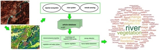
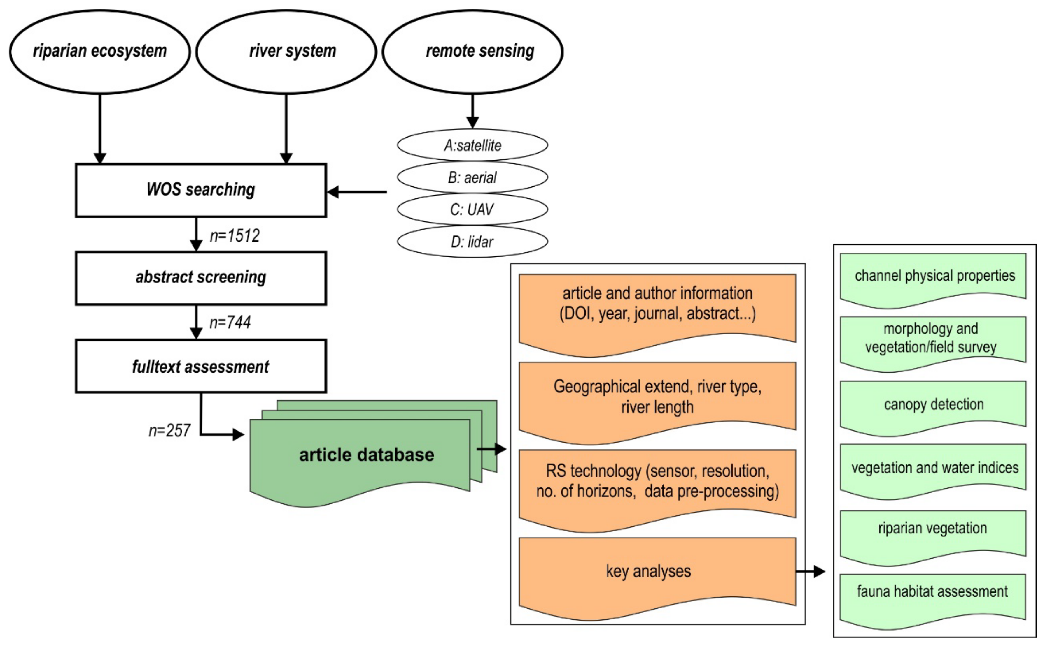
2. Database Processing
- The first group included articles related to the riparian ecosystem: “riparia*”, “floodplain*”, “ecosys*”, “vegeta*”, “change”, “success*”, “biogeo*”, and “ecol*”.
- The second group focused on river system specification: “river*”, “channel*”, “fluvial*”, “hydromorph*”, “hydro*”, “planform*”, and “morpho*”. To refine the results, we used the operation NOT with topics such as “estuary” OR “coast” to focus primarily on river systems.
- The third group was related to the remote sensing methods used in the article. In this case, we separated four basic types of sensors: (A) satellites, “satellite*”, “remote*”, “Landsat”, “sentinel”, and “image*”; (B) aerial images, “remote*”, “aerial*“, “photogra*”, and “image*”; (C) UAVs (unmanned aerial vehicles), “uav”, “drone*”, “uas”, “SfM”, “*motion”, and “raps”; and (D) airborne lidars (“lidar*”), with the NOT operator and the other word groups used to decrease noise within the search.
3. Quantitative Analysis of the WOS Database
3.1. Search Results
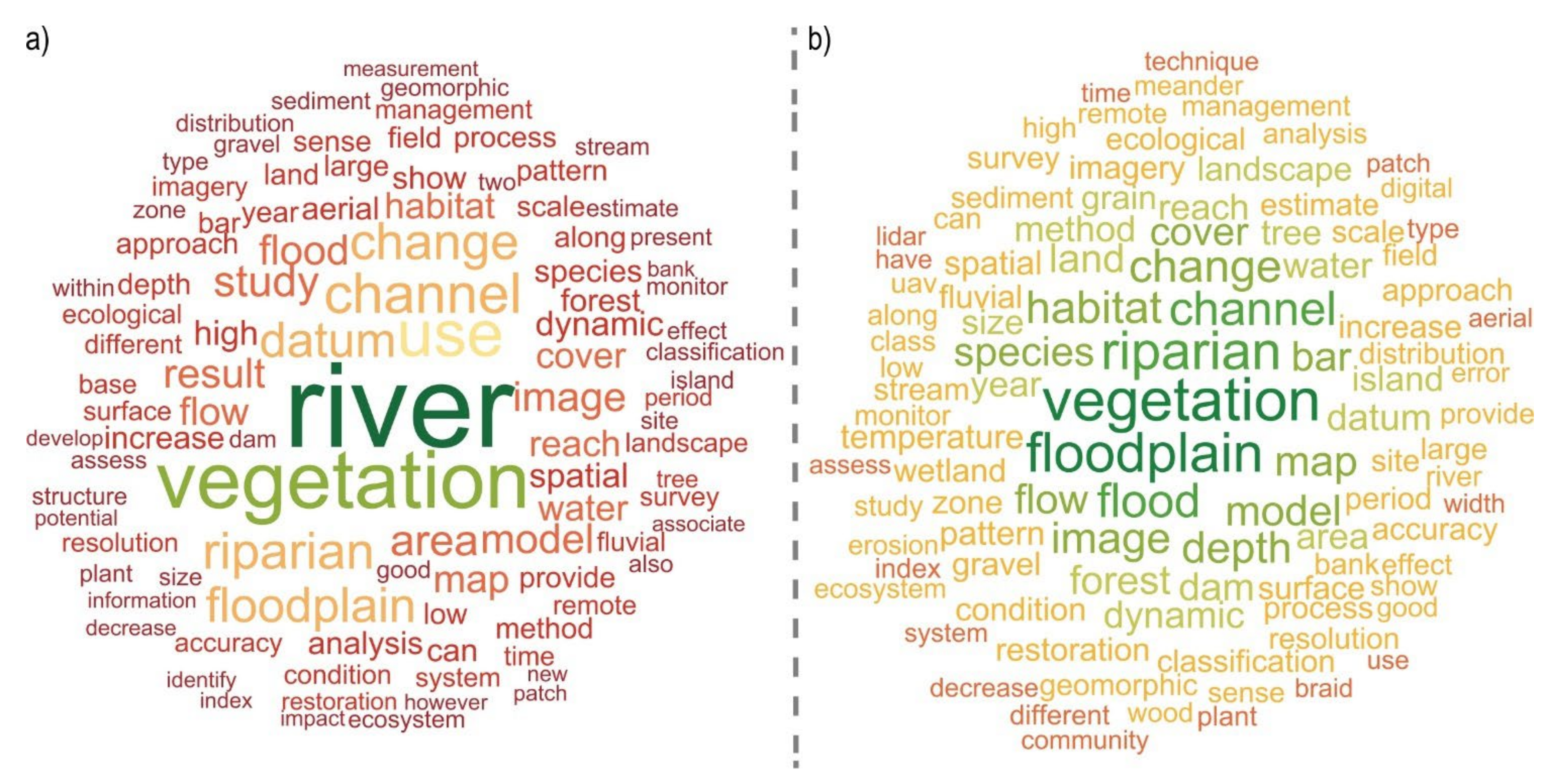
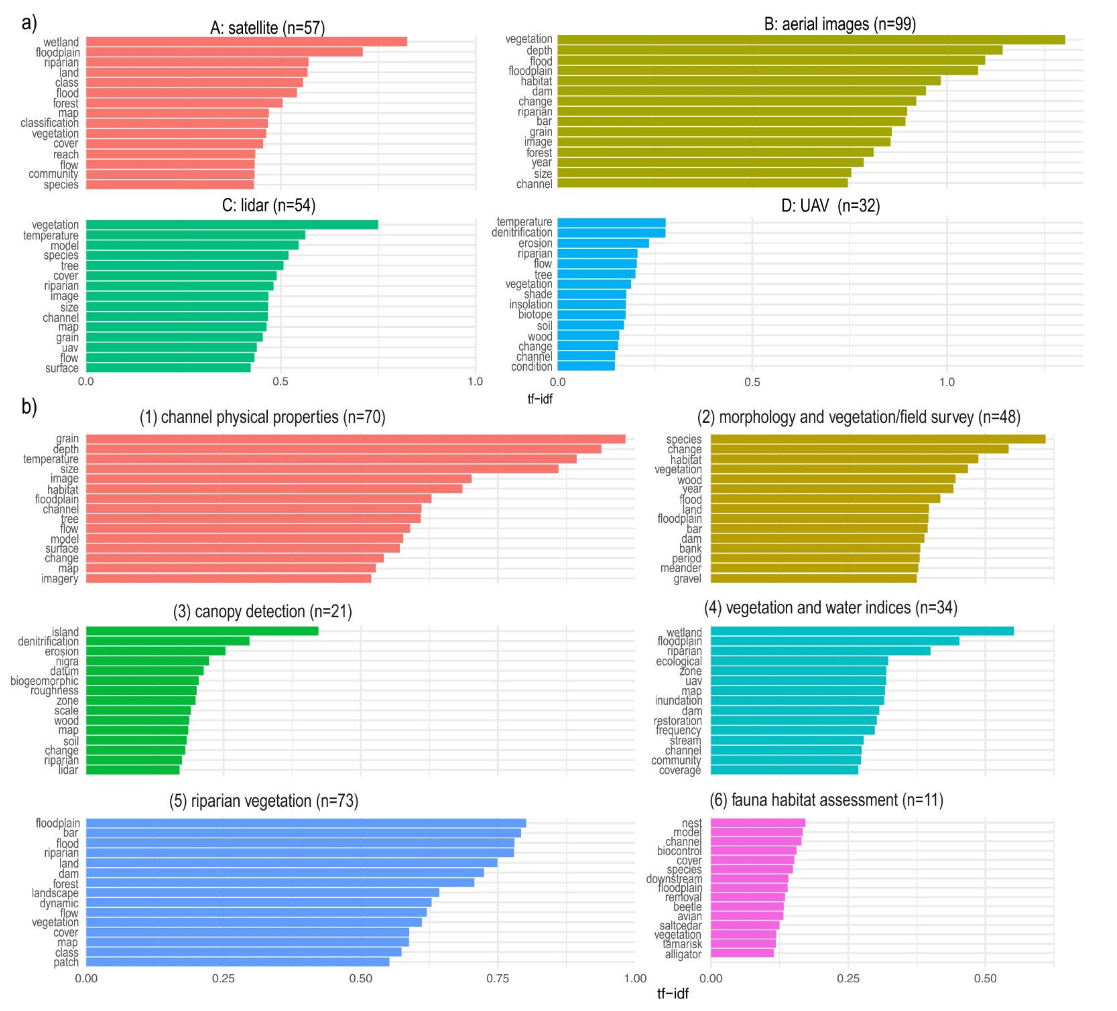
3.2. Abstract Term Analysis
- Channel physical properties: “grain”, “depth”, “temperature”, etc.;
- Morphology and vegetation or field survey: “species”, “change”, “habitat”, etc.;
- Canopy detection: “island”, “denitrification”, “erosion”, etc.;
- Application of vegetation and water indices: “wetland”, “floodplain”, “riparial”, etc.;
- Riparian vegetation: “floodplain”, “bar”, “flood”, etc.;
- Fauna habitat assessment: “nest”, “model”, “channel”, etc.
4. Remote Sensing Application in River System Research
4.1. Physical Properties of a River Channel Detected by Remote Sensing

| Feature | Description | Sensor (Data) | References |
|---|---|---|---|
| Grain size | Detecting the textural variations (image semivariance, entropy) and optical granulometry | Aerial images/non-metric camera from helicopter survey | [39,40,41,57] |
| Hyperspectral images | [58] | ||
| UAV (digital camera) | [59,60,61] | ||
| Point cloud properties (roughness) related to grain size | UAV (digital camera) | [42,43] | |
| Bathymetry | Optical bathymetry: channel topography | Satellite (WorldView-2) | [62] |
| Multispectral/hyperspectral | [27,63,64] | ||
| Aerial images/non-metric camera | [65,66,67,68] | ||
| UAV (digital camera) | [69,70,71,72] | ||
| Optical bathymetry: sensor comparison | Multispectral WorldView-3, Airborne hyperspectral CASI, UAS-based hyperspectral, Bathymetric LiDAR | [73] | |
| Optical bathymetry: absence of field data | Satellite (WorldView-2)/aerial images | [74,75] | |
| Optical bathymetry: effect of morphology | Hyperspectral | [76] | |
| Optical bathymetry: depth-reflectance relations | Hyperspectral | [77] | |
| Optical bathymetry: illumination correction | Aerial non-metric camera | [78] | |
| Optical bathymetry: field sampling distribution | Hyperspectral | [79] | |
| Light refraction correction (digital photogrammetry) | Aerial images | [80,81] | |
| Light refraction correction (water refraction correction for SfM) | UAV | [44,45,82,83] | |
| Surface flow velocity | Application of image velocimetry algorithms for flow velocity detection | UAV | [46,84,85,86,87,88,89,90] |
| River temperature | River temperature mapping | UAV and thermal imaging camera | [91,92,93] |
| Data for a river temperature model | UAV and thermal imaging camera | [94,95,96] | |
| Aerial lidar | [97] | ||
| Riparian shading on direct and diffuse solar radiation | Aerial lidar | [98,99,100] | |
| Habitat mapping | In-stream habitats classification and mapping | Hyperspectral/multispectral | [47,48,49,54] |
| UAV | [50,51,52,53] | ||
| Habitat conditions (stream condition index) | Lidar/multispectral | [101] | |
| DEM (bathymetry) and hydraulic modelling (velocity) for habitat detection | Hyperspectral | [55] | |
| UAV | [56,102] | ||
| Lidar | [103,104,105] | ||
| Riparian zone morphology | Floodplain 3D | Aerial images | [106,107] |
4.2. Floodplain and River Morphology Related to Vegetation and Field Survey
| Feature | Description | Sensor (Data) | References |
|---|---|---|---|
| Floodplain habitat | Habitat detection (combined with LC classification, vegetation survey) | Lidar/multispectral | [108] |
| Lidar | [109] | ||
| Lidar/aerial | [137,138] | ||
| Aerial images | [139,140,141] | ||
| LWD | LWD detection (related to the field survey, channel morphology or application of supervised classification) | Aerial images | [142] |
| Aerial images/lidar | [110] | ||
| UAV | [111,143] | ||
| Morphology and vegetation relationship + field data | Environmental controls on vegetation dynamics (relation morphology with vegetation survey and bed material sampling) | Aerial images | [112,113,114,144,145] |
| Aerial images/UAV | [146] | ||
| UAV (digital camera) | [30] | ||
| Flow regime changes and flooding on vegetation dynamics (relation morphology with field survey) | Satellite | [118] | |
| Aerial images | [115,116,117,119,147] | ||
| Environmental controls on vegetation dynamics (forest canopy metrics) | Aerial lidar | [120] | |
| Morphology + vegetation detection and classification (LC) | River morphology (bar age, channel pattern) with vegetation classification | Satellite | [121,122,148] |
| Aerial images | [123,124,125,126,127,128,149,150,151,152,153,154] | ||
| Effect of floods on river morphology and vegetation | Aerial images | [27,130,131] | |
| UAV (digital camera) | [129] | ||
| Effect of post-dam hydro alteration | Aerial images/satellite | [133] | |
| Aerial images | [132,134] | ||
| River restoration | UAV (digital camera) | [135] | |
| Floodplain roughness | Automated floodplain roughness parameterisation by assessing the vegetation spectral properties and field survey | Satellite (SPOT-5) | [136] |
4.3. Canopy Detection from RS
| Feature | Description | Sensor (Data) | References |
|---|---|---|---|
| Canopy height model (CHM) generation | Relation of CHM (tree height), vegetation survey (species, density, and diameter), and channel morphology | Aerial lidar | [158,161,167,174,175,176] |
| Aerial images | [164] | ||
| Aerial lidar/aerial images | [160,162,163] | ||
| Aerial lidar/satellite images | [177] | ||
| Using CHM for vegetation classification | Aerial images | [168] | |
| UAV (digital camera) | [169] | ||
| Direct relation CHM and biophysical properties of vegetation | Aerial lidar | [166] | |
| UAV (digital camera) | [165] | ||
| Compare stereophotogrammetry and Structure-from-Motion (SfM) for CHM generation | Aerial images/UAV | [170] | |
| CHM and floodplain roughness parameterisation (vegetation height) | Roughness impact in hydrodynamic modelling | Aerial lidar | [171,172] |
| Regression model for roughness from tree heights, spectral properties, and field survey | Multispectral/aerial lidar | [173,178] | |
| Vegetation and riverbank erosion | Generation of CHM and hydraulic modelling in HecRAS | Aerial lidar | [179] |
4.4. Application of Vegetation and Water Indices in Riparian Zone Assessment
| Feature | Description | Sensor (Data) | References |
|---|---|---|---|
| Vegetation and LC classification | Identification of vegetation cover and LC classification | Satellite | [182,183,184,185,187,212] |
| Satellite + UAV | [186,188] | ||
| Combination of vegetation indices and Field survey (biophysical parameters) for model parametrisation and vegetation classification | Satellite + lidar | [189] | |
| Satellite | [190,191] | ||
| Vegetation classification and succession phase assessment | Satellite | [192,193] | |
| UAV | [180] | ||
| Vegetation impact to changes in hydrology regime | Vegetation classification and effect of hydrology alterations (damming) | Satellite | [194] |
| Satellite + UAV | [181] | ||
| Relationships between NDVI and the groundwater depth | Satellite | [213] | |
| Floodplain LC and inundation frequency | Satellite | [195,196,197] | |
| Inundation detection | Inundated areas by classification images based on the water area frequency (WAF) index | Satellite | [198] |
| Hydrogeomorphic dynamics | Relationship between NDVI patterns and floodplain dynamics | Satellite | [199] |
| Ecological indicators | Assessment ecological condition of riparian zone based on VI | Satellite | [200,201,202,203] |
| Biomass | Mapping of aboveground biomass | Satellite | [204,206,207] |
| carbon stock estimations | UAV (multispectral images) | [205] | |
| Restoration | Using VI for restoration monitoring | Satellite | [208] |
| UAV (digital camera) | [209] | ||
| Management | Vegetation (VI) response to shifting management activities | Satellite | [210,211] |
4.5. Riparian Vegetation Analyses and Assessment
| Feature | Description | Sensor (Data) | References |
|---|---|---|---|
| Riparian vegetation detection | LC and vegetation classification in the riparian zone | Satellite | [216,219] |
| Aerial images/(satellite) | [218] | ||
| Aerial images | [215,217,220,268] | ||
| UAV (multispectral/digital camera) | [26,221,269] | ||
| Effect of floods on the vegetation LC and vegetation recruitment | Satellite | [222] | |
| Effect of damming on the vegetation LC | Satellite | [226] | |
| Aerial images | [223,224,225] | ||
| Disturbances and pressures on the vegetation LC | Aerial images | [227,229,230] | |
| Google Earth images | [228] | ||
| Changes in vegetation LC and landscape metrics calculation | Satellite | [231,232,233] | |
| Aerial images | [234,235,270] | ||
| Vegetation LC for ecological indicators assessment | Satellite | [271,272] | |
| Aerial images | [273] | ||
| Structure of LC for management plans | Satellite | [274] | |
| Aerial images | [275,276,277] | ||
| Vegetation dynamics simulation | Aerial images | [278] | |
| Vegetation variable from field survey and RS data | Multispectral | [279] | |
| Vegetation succession | Biogeomorphic succession supported with vegetation survey (dendrochronology) | Aerial images | [245,246] |
| Vegetation phase dynamics for identification of vegetation establishment (biogeomorphic phases) | Satellite | [243,280] | |
| Aerial images/satellite | [237,241] | ||
| Aerial images | [236,239,242,281] | ||
| Aerial images/lidar | [244,282] | ||
| UAV (digital camera) | [240] | ||
| Biogeomorphic phases detection and landscape metrics | Aerial images | [247,248,249] | |
| Vegetation colonisation and encroachment | Aerial images | [155,250] | |
| Multispectral/lidar | [283] | ||
| UAV (digital camera) | [251] | ||
| Vegetation communities/species classification | Manual classification of riparian vegetation | Aerial images/satellite | [252,284] |
| Aerial images | [254,255] | ||
| UAV (digital camera) | [253] | ||
| Unsupervised (ISODATA) classification of riparian vegetation | Hyperspectral/lidar | [256] | |
| Supervised classification | Satellite | [257,259,260] | |
| Hyperspectral | [258] | ||
| Invasive riparian vegetation | Manual classification | Satellite/aerial non-metric camera | [285] |
| Aerial images | [264,265] | ||
| Supervised classification | Multispectral | [263] | |
| UAV (RGB, multispectral camera) | [261,262] | ||
| Aquatic vegetation | Manual classification | UAV (digital camera) | [266,267] |
| Supervised classification | UAV (digital camera) | [33] |
4.6. Fauna Habitat Assessment in the Riparian Zone
| Feature | Description | Sensor (Data) | References |
|---|---|---|---|
| Fish habitat detection | Habitat complexity assessment and distribution | Satellite | [288] |
| Aerial images | [287,289,290] | ||
| Aerial lidar | [286] | ||
| Habitat sustainability | Fish habitat preference | Satellite | [291] |
| Satellite/lidar | [292] | ||
| Suitability index for alligator/caiman | Satellite | [294] | |
| Satellite/lidar | [293] | ||
| Insect habitat prediction based on VI | Satellite | [295,296] | |
| Predictive models for avian abundance and species richness | Satellite | [297] |
5. Remote Sensing in the Riparian Zone: Global Challenges and Opportunities
- -
- Knowledge transfer between the evolution of remote sensing processing and river scientists or managers;
- -
- The technical availability of user-friendly methods and its routine application in river research;
- -
- The effectiveness of RS techniques for information mining;
- -
- The transfer of pixel data to processes and the integration of quantitative and qualitative information;
- -
- Near real-time monitoring;
- -
- Data mining;
- -
- Open data repositories and policies.
6. Conclusions
Author Contributions
Funding
Acknowledgments
Conflicts of Interest
References
- Škarpich, V.; Hradecký, J.; Dušek, R. Complex transformation of the geomorphic regime of channels in the forefield of the Moravskoslezské Beskydy Mts.: Case study of the Morávka River (Czech Republic). CATENA 2013, 111, 25–40. [Google Scholar] [CrossRef]
- Liébault, F.; Piégay, H. Causes of 20th century channel narrowing in mountain and piedmont rivers of southeastern France. Earth Surf. Process. Landf. 2002, 27, 425–444. [Google Scholar] [CrossRef]
- Scorpio, V.; Rosskopf, C.M. Channel adjustments in a Mediterranean river over the last 150 years in the context of anthropic and natural controls. Geomorphology 2016, 275, 90–104. [Google Scholar] [CrossRef]
- Ziliani, L.; Surian, N. Evolutionary trajectory of channel morphology and controlling factors in a large gravel-bed river. Geomorphology 2012, 173–174, 104–117. [Google Scholar] [CrossRef]
- Zawiejska, J.; Wyżga, B. Twentieth-century channel change on the Dunajec River, southern Poland: Patterns, causes and controls. Geomorphology 2010, 117, 234–246. [Google Scholar] [CrossRef]
- Wyżga, B.; Zawiejska, J.; Radecki-Pawlik, A. Impact of channel incision on the hydraulics of flood flows: Examples from Polish Carpathian rivers. Geomorphology 2016, 272, 10–20. [Google Scholar] [CrossRef]
- Naiman, R.J.; Décamps, H. The Ecology of Interfaces: Riparian Zones. Annu. Rev. Ecol. Syst. 1997, 28, 621–658. [Google Scholar] [CrossRef] [Green Version]
- Naiman, R.J.; Décamps, H.; McClain, M.E.; Likens, G.E. Riparia; Elsevier: Amsterdam, The Netherlands, 2005; ISBN 9780126633153. [Google Scholar]
- Gregory, S.V.; Swanson, F.J.; McKee, W.A.; Cummins, K.W. An Ecosystem Perspective of Riparian Zones. Bioscience 1991, 41, 540–551. [Google Scholar] [CrossRef]
- Brierley, G.J.; Fryirs, K.A. (Eds.) Geomorphology and River Management; Blackwell Publishing: Malden, MA, USA, 2004; ISBN 9780470751367. [Google Scholar]
- Scorpio, V.; Zen, S.; Bertoldi, W.; Surian, N.; Mastronunzio, M.; Dai Prá, E.; Zolezzi, G.; Comiti, F. Channelization of a large Alpine river: What is left of its original morphodynamics? Earth Surf. Process. Landf. 2018, 43, 1044–1062. [Google Scholar] [CrossRef]
- Rădoane, M.; Obreja, F.; Cristea, I.; Mihailă, D. Changes in the channel-bed level of the eastern Carpathian rivers: Climatic vs. human control over the last 50 years. Geomorphology 2013, 193, 91–111. [Google Scholar] [CrossRef]
- Brierley, G.J.; Mum, C.P. European impacts on downstream sediment transfer and bank erosion in Cobargo catchment, New South Wales, Australia. CATENA 1997, 31, 119–136. [Google Scholar] [CrossRef]
- James, L.A. Channel incision on the Lower American River, California, from streamflow gage records. Water Resour. Res. 1997, 33, 485–490. [Google Scholar] [CrossRef]
- Hooke, J.M. Variations in flood magnitude–effect relations and the implications for flood risk assessment and river management. Geomorphology 2015, 251, 91–107. [Google Scholar] [CrossRef]
- Kijowska-Strugała, M.; Wiejaczka, Ł.; Gil, E.; Bochenek, W.; Kiszka, K. The impact of extreme hydro-meteorological events on the transformation of mountain river channels (Polish Flysch Carpathians). Z. Für Geomorphol. 2017, 61, 75–89. [Google Scholar] [CrossRef]
- Gorczyca, E.; Krzemień, K.; Wrońska-Wałach, D.; Sobucki, M. Channel Changes due to Extreme Rainfalls in the Polish Carpathians. In Geomorphological Impacts of Extreme Weather; Springer: Dordrecht, The Netherlands, 2013; pp. 23–35. [Google Scholar]
- Bendix, J.; Hupp, C.R. Hydrological and geomorphological impacts on riparian plant communities. Hydrol. Process. 2000, 14, 2977–2990. [Google Scholar] [CrossRef]
- Hupp, C.R.; Bornette, G. Vegetation as a Tool in the Interpretation of Fluvial Geomorphic Processes and Landforms in Humid Temperate Areas. In Tools in Fluvial Geomorphology; John Wiley & Sons, Ltd.: Chichester, UK, 2005; pp. 269–288. ISBN 9780470868331. [Google Scholar]
- Parsons, M.; Thoms, M.C. Hierarchical patterns of physical–biological associations in river ecosystems. Geomorphology 2007, 89, 127–146. [Google Scholar] [CrossRef]
- Francis, R.A.; Corenblit, D.; Edwards, P.J. Perspectives on biogeomorphology, ecosystem engineering and self-organisation in island-braided fluvial ecosystems. Aquat. Sci. 2009, 71, 290–304. [Google Scholar] [CrossRef]
- Corenblit, D.; Steiger, J.; Gurnell, A.M.; Tabacchi, E.; Roques, L. Control of sediment dynamics by vegetation as a key function driving biogeomorphic succession within fluvial corridors. Earth Surf. Process. Landf. 2009, 34, 1790–1810. [Google Scholar] [CrossRef]
- Hestir, E.L.; Brando, V.E.; Bresciani, M.; Giardino, C.; Matta, E.; Villa, P.; Dekker, A.G. Measuring freshwater aquatic ecosystems: The need for a hyperspectral global mapping satellite mission. Remote Sens. Environ. 2015, 167, 181–195. [Google Scholar] [CrossRef] [Green Version]
- Tomsett, C.; Leyland, J. Remote sensing of river corridors: A review of current trends and future directions. River Res. Appl. 2019, 35, 779–803. [Google Scholar] [CrossRef]
- Merritt, D.M.; Scott, M.L.; Leroy Poff, N.; Auble, G.T.; Lytle, D.A. Theory, methods and tools for determining environmental flows for riparian vegetation: Riparian vegetation-flow response guilds. Freshw. Biol. 2010, 55, 206–225. [Google Scholar] [CrossRef]
- Carbonneau, P.E.; Dugdale, S.J.; Breckon, T.P.; Dietrich, J.T.; Fonstad, M.A.; Miyamoto, H.; Woodget, A.S. Adopting deep learning methods for airborne RGB fluvial scene classification. Remote Sens. Environ. 2020, 251, 112107. [Google Scholar] [CrossRef]
- Bryant, R.G.; Gilvear, D.J. Quantifying geomorphic and riparian land cover changes either side of a large flood event using airborne remote sensing: River Tay, Scotland. Geomorphology 1999, 29, 307–321. [Google Scholar] [CrossRef]
- Hestir, E.L.; Greenberg, J.A.; Ustin, S.L. Classification trees for aquatic vegetation community prediction from imaging spectroscopy. IEEE J. Sel. Top. Appl. Earth Obs. Remote Sens. 2012, 5, 1572–1584. [Google Scholar] [CrossRef]
- Notaro, M.; Emmett, K.; O’Leary, D. Spatio-temporal variability in remotely sensed vegetation greenness across Yellowstone National Park. Remote Sens. 2019, 11, 798. [Google Scholar] [CrossRef] [Green Version]
- Davis, J.; Blesius, L.; Slocombe, M.; Maher, S.; Vasey, M.; Christian, P.; Lynch, P. Unpiloted aerial system (UAS)-supported biogeomorphic analysis of restored sierra nevada montane meadows. Remote Sens. 2020, 12, 1828. [Google Scholar] [CrossRef]
- Liang, L.; Qin, Z.; Zhao, S.; Di, L.; Zhang, C.; Deng, M.; Lin, H.; Zhang, L.; Wang, L.; Liu, Z. Estimating crop chlorophyll content with hyperspectral vegetation indices and the hybrid inversion method. Int. J. Remote Sens. 2016, 37, 2923–2949. [Google Scholar] [CrossRef]
- Legleiter, C.J.; Roberts, D.A. A forward image model for passive optical remote sensing of river bathymetry. Remote Sens. Environ. 2009, 113, 1025–1045. [Google Scholar] [CrossRef]
- Flynn, K.; Chapra, S. Remote Sensing of Submerged Aquatic Vegetation in a Shallow Non-Turbid River Using an Unmanned Aerial Vehicle. Remote Sens. 2014, 6, 12815–12836. [Google Scholar] [CrossRef] [Green Version]
- Dufour, S.; Rodríguez-González, P.M.; Laslier, M. Tracing the scientific trajectory of riparian vegetation studies: Main topics, approaches and needs in a globally changing world. Sci. Total Environ. 2019, 653, 1168–1185. [Google Scholar] [CrossRef]
- Poledniková, Z.; Galia, T. Ecosystem Services of Large Wood: Mapping the Research Gap. Water 2021, 13, 2594. [Google Scholar] [CrossRef]
- Feinerer, I.; Hornik, K.; Meyer, D. Text Mining Infrastructure in R. J. Stat. Softw. 2008, 25, 1–17. [Google Scholar] [CrossRef] [Green Version]
- Rajaraman, A.; Ullman, J.D. Data Mining. In Mining of Massive Datasets; Cambridge University Press: Cambridge, UK, 2011; pp. 1–17. [Google Scholar]
- Wolman, M.G. A method of sampling coarse river-bed material. Trans. Am. Geophys. Union 1954, 35, 951–956. [Google Scholar] [CrossRef]
- Dugdale, S.J.; Carbonneau, P.E.; Campbell, D. Aerial photosieving of exposed gravel bars for the rapid calibration of airborne grain size maps. Earth Surf. Process. Landf. 2010, 35, 627–639. [Google Scholar] [CrossRef]
- Carbonneau, P.E.; Lane, S.N.; Bergeron, N.E. Catchment-scale mapping of surface grain size in gravel bed rivers using airborne digital imagery. Water Resour. Res. 2004, 40, W07202. [Google Scholar] [CrossRef] [Green Version]
- Verdú, J.M.; Batalla, R.J.; Martínez-Casasnovas, J.A. High-resolution grain-size characterisation of gravel bars using imagery analysis and geo-statistics. Geomorphology 2005, 72, 73–93. [Google Scholar] [CrossRef]
- Woodget, A.S.; Austrums, R. Subaerial gravel size measurement using topographic data derived from a UAV-SfM approach. Earth Surf. Process. Landf. 2017, 42, 1434–1443. [Google Scholar] [CrossRef]
- Woodget, A.S.; Fyffe, C.; Carbonneau, P.E. From manned to unmanned aircraft: Adapting airborne particle size mapping methodologies to the characteristics of sUAS and SfM. Earth Surf. Process. Landf. 2018, 43, 857–870. [Google Scholar] [CrossRef]
- Woodget, A.S.; Carbonneau, P.E.; Visser, F.; Maddock, I.P. Quantifying submerged fluvial topography using hyperspatial resolution UAS imagery and structure from motion photogrammetry. Earth Surf. Process. Landf. 2015, 40, 47–64. [Google Scholar] [CrossRef] [Green Version]
- Dietrich, J.T. Bathymetric Structure-from-Motion: Extracting shallow stream bathymetry from multi-view stereo photogrammetry. Earth Surf. Process. Landf. 2017, 42, 355–364. [Google Scholar] [CrossRef]
- Pearce, S.; Ljubičić, R.; Peña-Haro, S.; Perks, M.; Tauro, F.; Pizarro, A.; Dal Sasso, S.; Strelnikova, D.; Grimaldi, S.; Maddock, I.; et al. An Evaluation of Image Velocimetry Techniques under Low Flow Conditions and High Seeding Densities Using Unmanned Aerial Systems. Remote Sens. 2020, 12, 232. [Google Scholar] [CrossRef] [Green Version]
- Marcus, W.A.; Legleiter, C.J.; Aspinall, R.J.; Boardman, J.W.; Crabtree, R.L. High spatial resolution hyperspectral mapping of in-stream habitats, depths, and woody debris in mountain streams. Geomorphology 2003, 55, 363–380. [Google Scholar] [CrossRef]
- Marcus, W.A. Mapping of stream microhabitats with high spatial resolution hyperspectral imagery. J. Geogr. Syst. 2002, 4, 113–126. [Google Scholar] [CrossRef]
- Lorang, M.S.; Whited, D.C.; Hauer, F.R.; Kimball, J.S.; Stanford, J.A. Using airborne multispectral imagery to evaluate geomorphic work across floodplains of gravel-bed rivers. Ecol. Appl. 2005, 15, 1209–1222. [Google Scholar] [CrossRef] [Green Version]
- Woodget, A.S.; Visser, F.; Maddock, I.P.; Carbonneau, P.E. The Accuracy and Reliability of Traditional Surface Flow Type Mapping: Is it Time for a New Method of Characterizing Physical River Habitat? River Res. Appl. 2016, 32, 1902–1914. [Google Scholar] [CrossRef] [Green Version]
- Kalacska, M.; Lucanus, O.; Sousa, L.; Vieira, T.; Arroyo-Mora, J. Freshwater Fish Habitat Complexity Mapping Using Above and Underwater Structure-From-Motion Photogrammetry. Remote Sens. 2018, 10, 1912. [Google Scholar] [CrossRef] [Green Version]
- Casado, M.; Gonzalez, R.; Kriechbaumer, T.; Veal, A. Automated Identification of River Hydromorphological Features Using UAV High Resolution Aerial Imagery. Sensors 2015, 15, 27969–27989. [Google Scholar] [CrossRef] [Green Version]
- Woodget, A.S.; Austrums, R.; Maddock, I.P.; Habit, E. Drones and digital photogrammetry: From classifications to continuums for monitoring river habitat and hydromorphology. Wiley Interdiscip. Rev. Water 2017, 4, e1222. [Google Scholar] [CrossRef] [Green Version]
- Konrad, C.P.; Black, R.W.; Voss, F.; Neale, C.M.U. Integrating remotely acquired and field data to assess effects of setback levees on riparian and aquatic habitat in glacial-melt water rivers. River Res. Appl. 2008, 24, 355–372. [Google Scholar] [CrossRef]
- Hauer, F.R.; Lorang, M.S. River regulation, decline of ecological resources, and potential for restoration in a semi-arid lands river in the western USA. Aquat. Sci. 2004, 66, 388–401. [Google Scholar] [CrossRef]
- Tamminga, A.; Hugenholtz, C.; Eaton, B.; Lapointe, M. Hyperspatial Remote Sensing of Channel Reach Morphology and Hydraulic Fish Habitat Using an Unmanned Aerial Vehicle (UAV): A First Assessment in the Context of River Research and Management. River Res. Appl. 2015, 31, 379–391. [Google Scholar] [CrossRef]
- Carbonneau, P.E.; Bergeron, N.; Lane, S.N. Automated grain size measurements from airborne remote sensing for long profile measurements of fluvial grain sizes. Water Resour. Res. 2005, 41, 1–9. [Google Scholar] [CrossRef] [Green Version]
- Black, M.; Carbonneau, P.; Church, M.; Warburton, J. Mapping sub-pixel fluvial grain sizes with hyperspatial imagery. Sedimentology 2014, 61, 691–711. [Google Scholar] [CrossRef] [Green Version]
- Lang, N.; Irniger, A.; Rozniak, A.; Hunziker, R.; Wegner, J.D.; Schindler, K. GRAINet: Mapping grain size distributions in river beds from UAV images with convolutional neural networks. Hydrol. Earth Syst. Sci. 2021, 25, 2567–2597. [Google Scholar] [CrossRef]
- Langhammer, J.; Lendzioch, T.; Miřijovský, J.; Hartvich, F. UAV-Based Optical Granulometry as Tool for Detecting Changes in Structure of Flood Depositions. Remote Sens. 2017, 9, 240. [Google Scholar] [CrossRef] [Green Version]
- Carbonneau, P.E.; Bizzi, S.; Marchetti, G. Robotic photosieving from low-cost multirotor sUAS: A proof-of-concept. Earth Surf. Process. Landf. 2018, 43, 1160–1166. [Google Scholar] [CrossRef] [Green Version]
- Legleiter, C.J.; Overstreet, B.T. Mapping gravel bed river bathymetry from space. J. Geophys. Res. Earth Surf. 2012, 117, F04024. [Google Scholar] [CrossRef]
- Legleiter, C.J. Mapping River Depth from Publicly Available Aerial Images. River Res. Appl. 2013, 29, 760–780. [Google Scholar] [CrossRef]
- Legleiter, C.J. Inferring river bathymetry via Image-to-Depth Quantile Transformation (IDQT). Water Resour. Res. 2016, 52, 3722–3741. [Google Scholar] [CrossRef] [Green Version]
- Flener, C. Estimating deep water radiance in shallow water: Adapting optical bathymetry modelling to shallow river environments. Boreal Environ. Res. 2013, 18, 488–502. [Google Scholar]
- Westaway, R.M.; Lane, S.N.; Hicks, D.M. Remote survey of large-scale braided, gravel-bed rivers using digital photogrammetry and image analysis. Int. J. Remote Sens. 2003, 24, 795–815. [Google Scholar] [CrossRef]
- Brasington, J.; Langham, J.; Rumsby, B. Methodological sensitivity of morphometric estimates of coarse fluvial sediment transport. Geomorphology 2003, 53, 299–316. [Google Scholar] [CrossRef]
- Williams, R.D.; Brasington, J.; Vericat, D.; Hicks, D.M. Hyperscale terrain modelling of braided rivers: Fusing mobile terrestrial laser scanning and optical bathymetric mapping. Earth Surf. Process. Landf. 2014, 39, 167–183. [Google Scholar] [CrossRef]
- Javernick, L.; Brasington, J.; Caruso, B. Modeling the topography of shallow braided rivers using Structure-from-Motion photogrammetry. Geomorphology 2014, 213, 166–182. [Google Scholar] [CrossRef]
- Flener, C.; Vaaja, M.; Jaakkola, A.; Krooks, A.; Kaartinen, H.; Kukko, A.; Kasvi, E.; Hyyppä, H.; Hyyppä, J.; Alho, P. Seamless Mapping of River Channels at High Resolution Using Mobile LiDAR and UAV-Photography. Remote Sens. 2013, 5, 6382–6407. [Google Scholar] [CrossRef] [Green Version]
- Lejot, J.; Delacourt, C.; Piégay, H.; Fournier, T.; Trémélo, M.-L.; Allemand, P. Very high spatial resolution imagery for channel bathymetry and topography from an unmanned mapping controlled platform. Earth Surf. Process. Landf. 2007, 32, 1705–1725. [Google Scholar] [CrossRef]
- Legleiter, C.J.; Kinzel, P.J. Improving Remotely Sensed River Bathymetry by Image-Averaging. Water Resour. Res. 2021, 57, e2020WR028795. [Google Scholar] [CrossRef]
- Legleiter, C.J.; Harrison, L.R. Remote Sensing of River Bathymetry: Evaluating a Range of Sensors, Platforms, and Algorithms on the Upper Sacramento River, California, USA. Water Resour. Res. 2019, 55, 2142–2169. [Google Scholar] [CrossRef]
- Legleiter, C.J. Calibrating remotely sensed river bathymetry in the absence of field measurements: Flow REsistance Equation-Based Imaging of River Depths (FREEBIRD). Water Resour. Res. 2015, 51, 2865–2884. [Google Scholar] [CrossRef]
- Fonstad, M.A.; Marcus, W.A. Remote sensing of stream depths with hydraulically assisted bathymetry (HAB) models. Geomorphology 2005, 72, 320–339. [Google Scholar] [CrossRef]
- Legleiter, C.J.; Roberts, D.A. Effects of channel morphology and sensor spatial resolution on image-derived depth estimates. Remote Sens. Environ. 2005, 95, 231–247. [Google Scholar] [CrossRef] [Green Version]
- Legleiter, C.; Fosness, R. Defining the Limits of Spectrally Based Bathymetric Mapping on a Large River. Remote Sens. 2019, 11, 665. [Google Scholar] [CrossRef] [Green Version]
- Carbonneau, P.E.; Lane, S.N.; Bergeron, N. Feature based image processing methods applied to bathymetric measurements from airborne remote sensing in fluvial environments. Earth Surf. Process. Landf. 2006, 31, 1413–1423. [Google Scholar] [CrossRef]
- Legleiter, C.; Overstreet, B.; Kinzel, P. Sampling Strategies to Improve Passive Optical Remote Sensing of River Bathymetry. Remote Sens. 2018, 10, 935. [Google Scholar] [CrossRef] [Green Version]
- Westaway, R.M.; Lane, S.N.; Hicks, D.M. Remote Sensing of Clear-Water, Shallow, Gravel-Bed Rivers Using Digital Photogrammetry. Photogramm. Eng. Remote Sens. 2001, 67, 1271–1281. [Google Scholar]
- Westaway, R.M.; Lane, S.N.; Hicks, D.M. The development of an automated correction procedure for digital photogrammetry for the study of wide, shallow, gravel-bed rivers. Earth Surf. Process. Landf. 2000, 25, 209–226. [Google Scholar] [CrossRef]
- Kasvi, E.; Salmela, J.; Lotsari, E.; Kumpula, T.; Lane, S.N. Comparison of remote sensing based approaches for mapping bathymetry of shallow, clear water rivers. Geomorphology 2019, 333, 180–197. [Google Scholar] [CrossRef]
- Woodget, A.S.; Dietrich, J.T.; Wilson, R.T. Quantifying Below-Water Fluvial Geomorphic Change: The Implications of Refraction Correction, Water Surface Elevations, and Spatially Variable Error. Remote Sens. 2019, 11, 2415. [Google Scholar] [CrossRef] [Green Version]
- Kinzel, P.; Legleiter, C. sUAS-Based Remote Sensing of River Discharge Using Thermal Particle Image Velocimetry and Bathymetric Lidar. Remote Sens. 2019, 11, 2317. [Google Scholar] [CrossRef] [Green Version]
- Eltner, A.; Bertalan, L.; Grundmann, J.; Perks, M.T.; Lotsari, E. Hydro-morphological mapping of river reaches using videos captured with UAS. Earth Surf. Process. Landforms 2021, 46, 2773–2787. [Google Scholar] [CrossRef]
- Eltner, A.; Sardemann, H.; Grundmann, J. Technical Note: Flow velocity and discharge measurement in rivers using terrestrial and unmanned-aerial-vehicle imagery. Hydrol. Earth Syst. Sci. 2020, 24, 1429–1445. [Google Scholar] [CrossRef] [Green Version]
- Strelnikova, D.; Paulus, G.; Käfer, S.; Anders, K.-H.; Mayr, P.; Mader, H.; Scherling, U.; Schneeberger, R. Drone-Based Optical Measurements of Heterogeneous Surface Velocity Fields around Fish Passages at Hydropower Dams. Remote Sens. 2020, 12, 384. [Google Scholar] [CrossRef] [Green Version]
- Tauro, F.; Porfiri, M.; Grimaldi, S. Surface flow measurements from drones. J. Hydrol. 2016, 540, 240–245. [Google Scholar] [CrossRef] [Green Version]
- Perks, M.T.; Dal Sasso, S.F.; Hauet, A.; Jamieson, E.; Le Coz, J.; Pearce, S.; Peña-Haro, S.; Pizarro, A.; Strelnikova, D.; Tauro, F.; et al. Towards harmonisation of image velocimetry techniques for river surface velocity observations. Earth Syst. Sci. Data 2020, 12, 1545–1559. [Google Scholar] [CrossRef]
- Pizarro, A.; Dal Sasso, S.F.; Manfreda, S. Refining image-velocimetry performances for streamflow monitoring: Seeding metrics to errors minimization. Hydrol. Process. 2020, 34, 5167–5175. [Google Scholar] [CrossRef]
- Kuhn, J.; Casas-Mulet, R.; Pander, J.; Geist, J. Assessing stream thermal heterogeneity and cold-water patches from UAV-based imagery: A matter of classification methods and metrics. Remote Sens. 2021, 13, 1379. [Google Scholar] [CrossRef]
- Dugdale, S.J.; Kelleher, C.A.; Malcolm, I.A.; Caldwell, S.; Hannah, D.M. Assessing the potential of drone-based thermal infrared imagery for quantifying river temperature heterogeneity. Hydrol. Process. 2019, 33, 1152–1163. [Google Scholar] [CrossRef]
- Tonolla, D.; Wolter, C.; Ruhtz, T.; Tockner, K. Linking fish assemblages and spatiotemporal thermal heterogeneity in a river-floodplain landscape using high-resolution airborne thermal infrared remote sensing and in-situ measurements. Remote Sens. Environ. 2012, 125, 134–146. [Google Scholar] [CrossRef]
- Dugdale, S.J.; Hannah, D.M.; Malcolm, I.A. An evaluation of different forest cover geospatial data for riparian shading and river temperature modelling. River Res. Appl. 2020, 36, 709–723. [Google Scholar] [CrossRef]
- Dugdale, S.J.; Malcolm, I.A.; Hannah, D.M. Drone-based Structure-from-Motion provides accurate forest canopy data to assess shading effects in river temperature models. Sci. Total Environ. 2019, 678, 326–340. [Google Scholar] [CrossRef]
- Willis, A.; Holmes, E. Eye in the Sky: Using UAV imagery of seasonal riverine canopy growth to model water temperature. Hydrology 2019, 6, 6. [Google Scholar] [CrossRef] [Green Version]
- Seixas, G.B.; Beechie, T.J.; Fogel, C.; Kiffney, P.M. Historical and Future Stream Temperature Change Predicted by a Lidar-Based Assessment of Riparian Condition and Channel Width. J. Am. Water Resour. Assoc. 2018, 54, 974–991. [Google Scholar] [CrossRef]
- Kałuza, T.; Sojka, M.; Wrózyński, R.; Jaskuła, J.; Zaborowski, S.; Hämmerling, M. Modeling of river channel shading as a factor for changes in hydromorphological conditions of small lowland rivers. Water 2020, 12, 527. [Google Scholar] [CrossRef] [Green Version]
- Loicq, P.; Moatar, F.; Jullian, Y.; Dugdale, S.J.; Hannah, D.M. Improving representation of riparian vegetation shading in a regional stream temperature model using LiDAR data. Sci. Total Environ. 2018, 624, 480–490. [Google Scholar] [CrossRef]
- Greenberg, J.A.; Hestir, E.L.; Riano, D.; Scheer, G.J.; Ustin, S.L. Using LiDAR Data Analysis to Estimate Changes in Insolation Under Large-Scale Riparian Deforestation. J. Am. Water Resour. Assoc. 2012, 48, 939–948. [Google Scholar] [CrossRef]
- Johansen, K.; Grove, J.; Denham, R.; Phinn, S. Assessing stream bank condition using airborne LiDAR and high spatial resolution image data in temperate semirural areas in Victoria, Australia. J. Appl. Remote Sens. 2013, 7, 073492. [Google Scholar] [CrossRef] [Green Version]
- Timm, R.K.; Caldwell, L.; Nelson, A.; Long, C.; Chilibeck, M.B.; Johnson, M.; Ross, K.; Muller, A.; Brown, J.M. Drones, hydraulics, and climate change: Inferring barriers to steelhead spawning migrations. WIREs Water 2019, 6, e1379. [Google Scholar] [CrossRef]
- Entwistle, N.; Heritage, G.; Milan, D. Ecohydraulic modelling of anabranching rivers. River Res. Appl. 2019, 35, 353–364. [Google Scholar] [CrossRef] [Green Version]
- Wyrick, J.R.; Pasternack, G.B. Geospatial organization of fluvial landforms in a gravel–cobble river: Beyond the riffle–pool couplet. Geomorphology 2014, 213, 48–65. [Google Scholar] [CrossRef] [Green Version]
- Hauer, C.; Mandlburger, G.; Schober, B.; Habersack, H. Morphologically related integrative management concept for reconnecting abandoned channels based on airborne lidar data and habitat modelling. River Res. Appl. 2014, 30, 537–556. [Google Scholar] [CrossRef]
- Hajdukiewicz, M.; Wyżga, B.; Hajdukiewicz, H.; Mikuś, P. Photogrammetric reconstruction of changes in vertical river position using archival aerial photos: Case study of the Czarny Dunajec River, Polish Carpathians. Acta Geophys. 2019, 67, 1–17. [Google Scholar] [CrossRef] [Green Version]
- Poole, G.C.; Stanford, J.A.; Frissell, C.A.; Running, S.W. Three-dimensional mapping of geomorphic controls on flood-plain hydrology and connectivity from aerial photos. Geomorphology 2002, 48, 329–347. [Google Scholar] [CrossRef]
- Hicks, D.M.; Shankar, U.; Duncan, M.J.; Rebuff, M.; Aberle, J. Use of Remote-Sensing with Two-Dimensional Hydrodynamic Models to Assess Impacts of Hydro-Operations on a Large, Braided, Gravel-Bed River: Waitaki River, New Zealand. In Braided Rivers; Blackwell Publishing Ltd.: Oxford, UK, 2009; pp. 311–326. [Google Scholar]
- Nuhlíčková, S.; Svetlík, J.; Šibíková, M.; Jarolímek, I.; Zuna-Kratky, T. Current distribution, microhabitat requirements and vulnerability of the Keeled Plump Bush-cricket (Isophya costata) at the north-western periphery of its range. J. Insect Conserv. 2021, 25, 65–76. [Google Scholar] [CrossRef]
- Ulloa, H.; Iroumé, A.; Mao, L.; Andreoli, A.; Diez, S.; Lara, L.E. Use of Remote Imagery to Analyse Changes in Morphology and Longitudinal Large Wood Distribution in the Blanco River After the 2008 Chaitén Volcanic Eruption, Southern Chile. Geogr. Ann. Ser. A Phys. Geogr. 2015, 97, 523–541. [Google Scholar] [CrossRef]
- MacVicar, B.J.; Piégay, H.; Henderson, A.; Comiti, F.; Oberlin, C.; Pecorari, E. Quantifying the temporal dynamics of wood in large rivers: Field trials of wood surveying, dating, tracking, and monitoring techniques. Earth Surf. Process. Landf. 2009, 34, 2031–2046. [Google Scholar] [CrossRef]
- Gurnell, A.M.; Bickerton, M.; Angold, P.; Bell, D.; Morrissey, I.; Petts, G.E.; Sadler, J. Morphological and ecological change on a meander bend: The role of hydrological processes and the application of GIS. Hydrol. Processes 1998, 12, 981–993. [Google Scholar] [CrossRef]
- Gilvear, D.; Willby, N. Channel dynamics and geomorphic variability as controls on gravel bar vegetation; River Tummel, Scotland. River Res. Appl. 2006, 22, 457–474. [Google Scholar] [CrossRef]
- Angiolini, C.; Nucci, A.; Frignani, F.; Landi, M. Using multivariate analyses to assess effects of fluvial type on plant species distribution in a Mediterranean river. Wetlands 2011, 31, 167–177. [Google Scholar] [CrossRef]
- Tiegs, S.D.; O’leary, J.F.; Pohl, M.M.; Munill, C.L. Flood disturbance and riparian species diversity on the Colorado River Delta. Biodivers. Conserv. 2005, 14, 1175–1194. [Google Scholar] [CrossRef] [Green Version]
- Choi, S.U.; Yoon, B.; Woo, H. Effects of dam-induced flow regime change on downstream river morphology and vegetation cover in the Hwang River, Korea. River Res. Appl. 2005, 21, 315–325. [Google Scholar] [CrossRef]
- Birken, A.S.; Cooper, D.J. Processes of tamarix invasion and floodplain development along the lower green river, Utah. Ecol. Appl. 2006, 16, 1103–1120. [Google Scholar] [CrossRef]
- Townsend, P.A. Relationships between vegetation patterns and hydroperiod on the Roanoke River floodplain, North Carolina. Plant Ecol. 2001, 156, 43–58. [Google Scholar] [CrossRef]
- Polzin, M.L.; Rood, S.B. Effective disturbance: Seedling safe sites and patch recruitment of riparian cottonwoods after a major flood of a mountain river. WETLANDS 2006, 26, 965–980. [Google Scholar] [CrossRef]
- Cienciala, P.; Nelson, A.D.; Haas, A.D.; Xu, Z. Lateral geomorphic connectivity in a fluvial landscape system: Unraveling the role of confinement, biogeomorphic interactions, and glacial legacies. Geomorphology 2020, 354, 107036. [Google Scholar] [CrossRef]
- Yousefi, S.; Pourghasemi, H.R.; Hooke, J.; Navratil, O.; Kidová, A. Changes in morphometric meander parameters identified on the Karoon River, Iran, using remote sensing data. Geomorphology 2016, 271, 55–64. [Google Scholar] [CrossRef] [Green Version]
- Bhunia, G.S.; Shit, P.K.; Pal, D.K. Channel dynamics associated with land use/cover change in Ganges river, India, 1989–2010. Spat. Inf. Res. 2016, 24, 437–449. [Google Scholar] [CrossRef]
- Yousefi, S.; Moradi, H.R.; Pourghasemi, H.R.; Khatami, R. Assessment of floodplain landuse and channel morphology within meandering reach of the Talar River in Iran using GIS and aerial photographs. Geocarto Int. 2018, 33, 1367–1380. [Google Scholar] [CrossRef]
- Michalková, M.; Piégay, H.; Kondolf, G.M.; Greco, S.E. Lateral erosion of the Sacramento River, California (1942–1999), and responses of channel and floodplain lake to human influences. Earth Surf. Process. Landf. 2011, 36, 257–272. [Google Scholar] [CrossRef]
- Segura-Beltrán, F.; Sanchis-Ibor, C. Assessment of channel changes in a Mediterranean ephemeral stream since the early twentieth century. The Rambla de Cervera, eastern Spain. Geomorphology 2013, 201, 199–214. [Google Scholar] [CrossRef]
- Llena, M.; Vericat, D.; Martínez-Casasnovas, J.A.; Smith, M.W. Geomorphic adjustments to multi-scale disturbances in a mountain river: A century of observations. CATENA 2020, 192, 104584. [Google Scholar] [CrossRef]
- Surian, N.; Ziliani, L.; Comiti, F.; Lenzi, M.A.; Mao, L. Channel adjustments and alteration of sediment fluxes in gravel-bed rivers of North-Eastern Italy: Potentials and limitations for channel recovery. River Res. Appl. 2009, 25, 551–567. [Google Scholar] [CrossRef]
- Greco, S.E.; Fremier, A.K.; Larsen, E.W.; Plant, R.E. A tool for tracking floodplain age land surface patterns on a large meandering river with applications for ecological planning and restoration design. Landsc. Urban Plan. 2007, 81, 354–373. [Google Scholar] [CrossRef]
- Rusnák, M.; Sládek, J.; Pacina, J.; Kidová, A. Monitoring of avulsion channel evolution and river morphology changes using UAV photogrammetry: Case study of the gravel bed Ondava River in Outer Western Carpathians. Area 2019, 51, 549–560. [Google Scholar] [CrossRef]
- Surian, N.; Barban, M.; Ziliani, L.; Monegato, G.; Bertoldi, W.; Comiti, F. Vegetation turnover in a braided river: Frequency and effectiveness of floods of different magnitude. Earth Surf. Process. Landf. 2015, 40, 542–558. [Google Scholar] [CrossRef]
- Philipsen, L.J.; Romuld, M.A.; Rood, S.B. Floodplain forest dynamics: Half-century floods enable pulses of geomorphic disturbance and cottonwood colonization along a prairie river. River Res. Appl. 2021, 37, 64–77. [Google Scholar] [CrossRef]
- Sanchis-Ibor, C.; Segura-Beltrán, F.; Navarro-Gómez, A. Channel forms and vegetation adjustment to damming in a Mediterranean gravel-bed river (Serpis River, Spain). River Res. Appl. 2019, 35, 37–47. [Google Scholar] [CrossRef] [Green Version]
- Casado, A.; Peiry, J.L.; Campo, A.M. Geomorphic and vegetation changes in a meandering dryland river regulated by a large dam, Sauce Grande River, Argentina. Geomorphology 2016, 268, 21–34. [Google Scholar] [CrossRef] [Green Version]
- Magdaleno, F.; Fernández, J.A. Hydromorphological alteration of a large Mediterranean river: Relative role of high and low flows on the evolution of riparian forests and channel morphology. River Res. Appl. 2011, 27, 374–387. [Google Scholar] [CrossRef]
- Marteau, B.; Vericat, D.; Gibbins, C.; Batalla, R.J.; Green, D.R. Application of Structure-from-Motion photogrammetry to river restoration. Earth Surf. Process. Landf. 2017, 42, 503–515. [Google Scholar] [CrossRef] [Green Version]
- Forzieri, G.; Degetto, M.; Righetti, M.; Castelli, F.; Preti, F. Satellite multispectral data for improved floodplain roughness modelling. J. Hydrol. 2011, 407, 41–57. [Google Scholar] [CrossRef]
- Choné, G.; Biron, P.M. Assessing the Relationship between River Mobility and Habitat. River Res. Appl. 2016, 32, 528–539. [Google Scholar] [CrossRef]
- Frazier, P.; Ryder, D.; Mcintyre, E.; Stewart, M. Understanding riverine habitat inundation patterns: Remote sensing tools and techniques. Wetlands 2012, 32, 225–237. [Google Scholar] [CrossRef]
- White, M.S.; Tavernia, B.G.; Shafroth, P.B.; Chapman, T.B.; Sanderson, J.S. Vegetative and geomorphic complexity at tributary junctions on the Colorado and Dolores Rivers: A blueprint for riparian restoration. Landsc. Ecol. 2018, 33, 2205–2220. [Google Scholar] [CrossRef]
- Doering, M.; Blaurock, M.; Robinson, C.T. Landscape transformation of an Alpine floodplain influenced by humans: Historical analyses from aerial images. Hydrol. Process. 2012, 26, 3319–3326. [Google Scholar] [CrossRef]
- Hohensinner, S.; Jungwirth, M.; Muhar, S.; Schmutz, S. Spatio-temporal habitat dynamics in a changing Danube River landscape 1812-2006. River Res. Appl. 2011, 27, 939–955. [Google Scholar] [CrossRef]
- MacNally, R.; Parkinson, A.; Horrocks, G.; Young, M. Current loads of coarse woody debris on southeastern Australian floodplains: Evaluation of change and implications for restoration. Restor. Ecol. 2002, 10, 627–635. [Google Scholar] [CrossRef]
- Rusnák, M.; Sládek, J.; Kidová, A.; Lehotský, M. Template for high-resolution river landscape mapping using UAV technology. Measurement 2018, 115, 139–151. [Google Scholar] [CrossRef]
- Shields, F.D. Woody vegetation and riprap stability along the sacramento river mile 84.5–119. J. Am. Water Resour. Assoc. 1991, 27, 527–536. [Google Scholar] [CrossRef]
- Cline, S.P.; McAllister, L.S. Plant succession after hydrologic disturbance: Inferences from contemporary vegetation on a chronosequence of bars, Willamette River, Oregon, USA. River Res. Appl. 2012, 28, 1519–1539. [Google Scholar] [CrossRef]
- Ikeda, H.; Iimura, K.; Komura, S.; Kawashima, C.; Sato, W. Vegetation transition and coarse sediment movement after gravel bar restoration with two meandering lanes in a steep river. J. Hydro-Environ. Res. 2020, 30, 25–34. [Google Scholar] [CrossRef]
- Kamisako, M.; Sannoh, K.; Kamitani, T. Does understory vegetation reflect the history of fluvial disturbance in a riparian forest? Ecol. Res. 2007, 22, 67–74. [Google Scholar] [CrossRef]
- Hazarika, N.; Das, A.K.; Borah, S.B. Assessing land-use changes driven by river dynamics in chronically flood affected Upper Brahmaputra plains, India, using RS-GIS techniques. Egypt. J. Remote Sens. Sp. Sci. 2015, 18, 107–118. [Google Scholar] [CrossRef] [Green Version]
- Kondolf, G.M.; Piégay, H.; Landon, N. Changes in the riparian zone of the lower Eygues River, France, since 1830. Landsc. Ecol. 2007, 22, 367–384. [Google Scholar] [CrossRef]
- Bertalan, L.; Novák, T.; Németh, Z.; Rodrigo-Comino, J.; Kertész, Á.; Szabó, S. Issues of Meander Development: Land Degradation or Ecological Value? The Example of the Sajó River, Hungary. Water 2018, 10, 1613. [Google Scholar] [CrossRef] [Green Version]
- García de Jalón, D.; Martínez-Fernández, V.; Fazelpoor, K.; González del Tánago, M. Vegetation encroachment ratios in regulated and non-regulated Mediterranean rivers (Spain): An exploratory overview. J. Hydro-Environ. Res. 2020, 30, 35–44. [Google Scholar] [CrossRef]
- Magdaleno, F.; Anastasio Fernández, J.; Merino, S. The Ebro River in the 20th century or the ecomorphological transformation of a large and dynamic Mediterranean channel. Earth Surf. Process. Landf. 2012, 37, 486–498. [Google Scholar] [CrossRef]
- Cadol, D.; Rathburn, S.L.; Cooper, D.J. Aerial photographic analysis of channel narrowing and vegetation expansion in Canyon De Chelly National Monument, Arizona, USA, 1935–2004. River Res. Appl. 2011, 27, 841–856. [Google Scholar] [CrossRef]
- Reid, H.E.; Brierley, G.J. Assessing geomorphic sensitivity in relation to river capacity for adjustment. Geomorphology 2015, 251, 108–121. [Google Scholar] [CrossRef]
- Kleinhans, M.; Douma, H.; Addink, E.A. Fate of pioneering vegetation patches in a dynamic meandering river. Earth Surf. Process. Landf. 2019, 44, 1618–1632. [Google Scholar] [CrossRef]
- Corenblit, D.; Steiger, J.; González, E.; Gurnell, A.M.; Charrier, G.; Darrozes, J.; Dousseau, J.; Julien, F.; Lambs, L.; Larrue, S.; et al. The biogeomorphological life cycle of poplars during the fluvial biogeomorphological succession: A special focus on Populus nigra L. Earth Surf. Process. Landf. 2014, 39, 546–563. [Google Scholar] [CrossRef]
- Corenblit, D.; Tabacchi, E.; Steiger, J.; Gurnell, A.M. Reciprocal interactions and adjustments between fluvial landforms and vegetation dynamics in river corridors: A review of complementary approaches. Earth-Sci. Rev. 2007, 84, 56–86. [Google Scholar] [CrossRef]
- Bertoldi, W.; Gurnell, A.M.; Welber, M. Wood recruitment and retention: The fate of eroded trees on a braided river explored using a combination of field and remotely-sensed data sources. Geomorphology 2013, 180–181, 146–155. [Google Scholar] [CrossRef]
- Bertoldi, W.; Gurnell, A.; Surian, N.; Tockner, K.; Zanoni, L.; Ziliani, L.; Zolezzi, G. Understanding reference processes: Linkages between river flows, sediment dynamics and vegetated landforms along the Tagliamento River, Italy. River Res. Appl. 2009, 25, 501–516. [Google Scholar] [CrossRef]
- Bertoldi, W.; Gurnell, A.M.; Drake, N.A. The topographic signature of vegetation development along a braided river: Results of a combined analysis of airborne lidar, color air photographs, and ground measurements. Water Resour. Res. 2011, 47, W06525. [Google Scholar] [CrossRef]
- Gurnell, A.M.; Bertoldi, W. Extending the conceptual model of river island development to incorporate different tree species and environmental conditions. River Res. Appl. 2020, 36, 1730–1747. [Google Scholar] [CrossRef]
- Picco, L.; Mao, L.; Rainato, R.; Lenzi, M.A. Medium-term fluvial island evolution in a disturbed gravel-bed river (piave river, northeastern italian alps). Geogr. Ann. Ser. A, Phys. Geogr. 2014, 96, 83–97. [Google Scholar] [CrossRef]
- Bertoldi, W.; Gurnell, A.M. Physical engineering of an island-braided river by two riparian tree species: Evidence from aerial images and airborne lidar. River Res. Appl. 2020, 36, rra.3657. [Google Scholar] [CrossRef]
- Corenblit, D.; Steiger, J.; Charrier, G.; Darrozes, J.; Garófano-Gómez, V.; Garreau, A.; González, E.; Gurnell, A.M.; Hortobágyi, B.; Julien, F.; et al. Populus nigra L. establishment and fluvial landform construction: Biogeomorphic dynamics within a channelized river. Earth Surf. Process. Landf. 2016, 41, 1276–1292. [Google Scholar] [CrossRef]
- Van Iersel, W.; Straatsma, M.; Addink, E.; Middelkoop, H. Monitoring height and greenness of non-woody floodplain vegetation with UAV time series. ISPRS J. Photogramm. Remote Sens. 2018, 141, 112–123. [Google Scholar] [CrossRef]
- Farid, A.; Goodrich, D.C.; Sorooshian, S. Using Airborne Lidar to Discern Age Classes of Cottonwood Trees in a Riparian Area. West. J. Appl. For. 2006, 21, 149–158. [Google Scholar] [CrossRef] [Green Version]
- Johansen, K.; Arroyo, L.A.; Armston, J.; Phinn, S.; Witte, C. Mapping riparian condition indicators in a sub-tropical savanna environment from discrete return LiDAR data using object-based image analysis. Ecol. Indic. 2010, 10, 796–807. [Google Scholar] [CrossRef]
- Picco, L.; Tonon, A.; Ravazzolo, D.; Rainato, R.; Lenzi, M.A. Monitoring river island dynamics using aerial photographs and lidar data: The tagliamento river study case. Appl. Geomat. 2015, 7, 163–170. [Google Scholar] [CrossRef]
- Woellner, R.; Wagner, T.C. Saving species, time and money: Application of unmanned aerial vehicles (UAVs) for monitoring of an endangered alpine river specialist in a small nature reserve. Biol. Conserv. 2019, 233, 162–175. [Google Scholar] [CrossRef]
- Hortobágyi, B.; Corenblit, D.; Vautier, F.; Steiger, J.; Roussel, E.; Burkart, A.; Peiry, J.L. A multi-scale approach of fluvial biogeomorphic dynamics using photogrammetry. J. Environ. Manag. 2017, 202, 348–362. [Google Scholar] [CrossRef] [PubMed]
- Abu-Aly, T.R.; Pasternack, G.B.; Wyrick, J.R.; Barker, R.; Massa, D.; Johnson, T. Effects of LiDAR-derived, spatially distributed vegetation roughness on two-dimensional hydraulics in a gravel-cobble river at flows of 0.2 to 20 times bankfull. Geomorphology 2014, 206, 468–482. [Google Scholar] [CrossRef] [Green Version]
- Hoyle, J.; Brooks, A.; Spencer, J. Modelling reach-scale variability in sediment mobility: An approach for within-reach prioritization of river rehabilitation works. River Res. Appl. 2012, 28, 609–629. [Google Scholar] [CrossRef] [Green Version]
- Forzieri, G.; Guarnieri, L.; Vivoni, E.R.; Castelli, F.; Preti, F. Spectral-ALS data fusion for different roughness parameterizations of forested floodplains. River Res. Appl. 2011, 27, 826–840. [Google Scholar] [CrossRef]
- Gurnell, A.M.; Bertoldi, W.; Francis, R.A.; Gurnell, J.; Mardhiah, U. Understanding processes of island development on an island braided river over timescales from days to decades. Earth Surf. Process. Landforms 2018, 44, 624–640. [Google Scholar] [CrossRef]
- Harms, T.K.; Wentz, E.A.; Grimm, N.B. Spatial heterogeneity of denitrification in semi-arid floodplains. Ecosystems 2009, 12, 129–143. [Google Scholar] [CrossRef]
- Young, J.; Welsch, D.; Deacon, S. Assessing the hydrologic impact of historical railroad embankments on wetland vegetation response in Canaan Valley, West Virginia: The value of high-resolution data. Restor. Ecol. 2020, 28, 51–62. [Google Scholar] [CrossRef]
- Johansen, K.; Phinn, S.; Witte, C. Mapping of riparian zone attributes using discrete return LiDAR, QuickBird and SPOT-5 imagery: Assessing accuracy and costs. Remote Sens. Environ. 2010, 114, 2679–2691. [Google Scholar] [CrossRef]
- Straatsma, M.W.; Baptist, M.J. Floodplain roughness parameterization using airborne laser scanning and spectral remote sensing. Remote Sens. Environ. 2008, 112, 1062–1080. [Google Scholar] [CrossRef]
- McMahon, J.M.; Olley, J.M.; Brooks, A.P.; Smart, J.C.R.; Stewart-Koster, B.; Venables, W.N.; Curwen, G.; Kemp, J.; Stewart, M.; Saxton, N.; et al. Vegetation and longitudinal coarse sediment connectivity affect the ability of ecosystem restoration to reduce riverbank erosion and turbidity in drinking water. Sci. Total Environ. 2020, 707, 135904. [Google Scholar] [CrossRef] [PubMed]
- Laslier, M.; Hubert-Moy, L.; Corpetti, T.; Dufour, S. Monitoring the colonization of alluvial deposits using multitemporal UAV RGB-imagery. Appl. Veg. Sci. 2019, 22, 561–572. [Google Scholar] [CrossRef]
- Lan, D.; Rui-Hong, Y. New grassland riparian zone delineation method for calculating ecological water demand to guide management goals. River Res. Appl. 2020, 36, 1838–1851. [Google Scholar] [CrossRef]
- Henshaw, A.J.; Gurnell, A.M.; Bertoldi, W.; Drake, N.A. An assessment of the degree to which Landsat TM data can support the assessment of fluvial dynamics, as revealed by changes in vegetation extent and channel position, along a large river. Geomorphology 2013, 202, 74–85. [Google Scholar] [CrossRef]
- Park, E.; Latrubesse, E.M. The hydro-geomorphologic complexity of the lower Amazon River floodplain and hydrological connectivity assessed by remote sensing and field control. Remote Sens. Environ. 2017, 198, 321–332. [Google Scholar] [CrossRef]
- Jia, M.; Mao, D.; Wang, Z.; Ren, C.; Zhu, Q.; Li, X.; Zhang, Y. Tracking long-term floodplain wetland changes: A case study in the China side of the Amur River Basin. Int. J. Appl. Earth Obs. Geoinf. 2020, 92, 102185. [Google Scholar] [CrossRef]
- Rabanaque, M.P.; Martínez-Fernández, V.; Calle, M.; Benito, G. Basin-wide hydromorphological analysis of ephemeral streams using machine learning algorithms ‡. Earth Surf. Process. Landf. 2022, 47, 328–344. [Google Scholar] [CrossRef]
- Daryaei, A.; Sohrabi, H.; Atzberger, C.; Immitzer, M. Fine-scale detection of vegetation in semi-arid mountainous areas with focus on riparian landscapes using Sentinel-2 and UAV data. Comput. Electron. Agric. 2020, 177, 105686. [Google Scholar] [CrossRef]
- Johansen, K.; Coops, N.C.; Gergel, S.E.; Stange, Y. Application of high spatial resolution satellite imagery for riparian and forest ecosystem classification. Remote Sens. Environ. 2007, 110, 29–44. [Google Scholar] [CrossRef]
- Morgan, B.E.; Chipman, J.W.; Bolger, D.T.; Dietrich, J.T. Spatiotemporal analysis of vegetation cover change in a large ephemeral river: Multi-sensor fusion of unmanned aerial vehicle (uav) and landsat imagery. Remote Sens. 2021, 13, 51. [Google Scholar] [CrossRef]
- Arroyo, L.A.; Johansen, K.; Armston, J.; Phinn, S. Integration of LiDAR and QuickBird imagery for mapping riparian biophysical parameters and land cover types in Australian tropical savannas. For. Ecol. Manag. 2010, 259, 598–606. [Google Scholar] [CrossRef]
- Johansen, K.; Phinn, S. Mapping Structural Parameters and Species Composition of Riparian Vegetation Using IKONOS and Landsat ETM+ Data in Australian Tropical Savannahs. Photogramm. Eng. Remote Sens. 2006, 72, 71–80. [Google Scholar] [CrossRef]
- Cunningham, S.C.; Mac Nally, R.; Read, J.; Baker, P.J.; White, M.; Thomson, J.R.; Griffioen, P. A robust technique for mapping vegetation condition across a major river system. Ecosystems 2009, 12, 207–219. [Google Scholar] [CrossRef]
- Bertoldi, W.; Drake, N.A.; Gurnell, A.M. Interactions between river flows and colonizing vegetation on a braided river: Exploring spatial and temporal dynamics in riparian vegetation cover using satellite data. Earth Surf. Process. Landf. 2011, 36, 1474–1486. [Google Scholar] [CrossRef]
- Han, M.; Brierley, G.; Li, B.; Li, Z.; Li, X. Impacts of flow regulation on geomorphic adjustment and riparian vegetation succession along an anabranching reach of the Upper Yellow River. CATENA 2020, 190, 104561. [Google Scholar] [CrossRef]
- Ablat, X.; Liu, G.; Liu, Q.; Huang, C. Application of Landsat derived indices and hydrological alteration matrices to quantify the response of floodplain wetlands to river hydrology in arid regions based on different dam operation strategies. Sci. Total Environ. 2019, 688, 1389–1404. [Google Scholar] [CrossRef]
- Deng, F.; Wang, X.; Cai, X.; Li, E.; Jiang, L.; Li, H.; Yan, R. Analysis of the relationship between inundation frequency and wetland vegetation in Dongting Lake using remote sensing data. Ecohydrology 2014, 7, 717–726. [Google Scholar] [CrossRef]
- Hopkinson, C.; Fuoco, B.; Grant, T.; Bayley, S.E.; Brisco, B.; Macdonald, R. Wetland hydroperiod change along the upper columbia river floodplain, canada, 1984 to 2019. Remote Sens. 2020, 12, 4084. [Google Scholar] [CrossRef]
- Broich, M.; Tulbure, M.G.; Verbesselt, J.; Xin, Q.; Wearne, J. Quantifying Australia’s dryland vegetation response to flooding and drought at sub-continental scale. Remote Sens. Environ. 2018, 212, 60–78. [Google Scholar] [CrossRef]
- Chen, L.; Wu, Y.; Xu, Y.J.; Zhang, G. Alteration of flood pulses by damming the Nenjiang River, China—Implication for the need to identify a hydrograph-based inundation threshold for protecting floodplain wetlands. Ecol. Indic. 2021, 124, 107406. [Google Scholar] [CrossRef]
- Marchetti, Z.Y.; Ramonell, C.G.; Brumnich, F.; Alberdi, R.; Kandus, P. Vegetation and hydrogeomorphic features of a large lowland river: NDVI patterns summarizing fluvial dynamics and supporting interpretations of ecological patterns. Earth Surf. Process. Landf. 2020, 45, 694–706. [Google Scholar] [CrossRef]
- Saha, D.; Das, D.; Dasgupta, R.; Patel, P.P. Application of ecological and aesthetic parameters for riparian quality assessment of a small tropical river in eastern India. Ecol. Indic. 2020, 117, 106627. [Google Scholar] [CrossRef]
- Langat, P.K.; Kumar, L.; Koech, R.; Ghosh, M.K. Characterisation of channel morphological pattern changes and flood corridor dynamics of the tropical Tana River fluvial systems, Kenya. J. African Earth Sci. 2020, 163, 103748. [Google Scholar] [CrossRef]
- Zhang, H.; Xue, L.; Wei, G.; Dong, Z.; Meng, X. Assessing Vegetation Dynamics and Landscape Ecological Risk on the Mainstream of Tarim River, China. Water 2020, 12, 2156. [Google Scholar] [CrossRef]
- Nagler, P.L.; Barreto-Muñoz, A.; Borujeni, S.C.; Nouri, H.; Jarchow, C.J.; Didan, K. Riparian area changes in greenness and water use on the lower Colorado river in the USA from 2000 to 2020. Remote Sens. 2021, 13, 1332. [Google Scholar] [CrossRef]
- Güneralp, İ.; Filippi, A.M.; Randall, J. Estimation of floodplain aboveground biomass using multispectral remote sensing and nonparametric modeling. Int. J. Appl. Earth Obs. Geoinf. 2014, 33, 119–126. [Google Scholar] [CrossRef]
- Fernandes, M.R.; Aguiar, F.C.; Martins, M.J.; Rico, N.; Ferreira, M.T.; Correia, A.C. Carbon Stock Estimations in a Mediterranean Riparian Forest: A Case Study Combining Field Data and UAV Imagery. Forests 2020, 11, 376. [Google Scholar] [CrossRef] [Green Version]
- Wang, Y.; Shen, X.; Jiang, M.; Tong, S.; Lu, X. Spatiotemporal change of aboveground biomass and its response to climate change in marshes of the Tibetan Plateau. Int. J. Appl. Earth Obs. Geoinf. 2021, 102, 102385. [Google Scholar] [CrossRef]
- Shen, X.; Jiang, M.; Lu, X.; Liu, X.; Liu, B.; Zhang, J.; Wang, X.; Tong, S.; Lei, G.; Wang, S.; et al. Aboveground biomass and its spatial distribution pattern of herbaceous marsh vegetation in China. Sci. China Earth Sci. 2021, 64, 1115–1125. [Google Scholar] [CrossRef]
- Silverman, N.L.; Allred, B.W.; Donnelly, J.P.; Chapman, T.B.; Maestas, J.D.; Wheaton, J.M.; White, J.; Naugle, D.E. Low-tech riparian and wet meadow restoration increases vegetation productivity and resilience across semiarid rangelands. Restor. Ecol. 2019, 27, 269–278. [Google Scholar] [CrossRef] [Green Version]
- Langhammer, J. UAV Monitoring of Stream Restorations. Hydrology 2019, 6, 29. [Google Scholar] [CrossRef] [Green Version]
- Petrakis, R.; van Leeuwen, W.; Villarreal, M.L.; Tashjian, P.; Dello Russo, R.; Scott, C. Historical Analysis of Riparian Vegetation Change in Response to Shifting Management Objectives on the Middle Rio Grande. Land 2017, 6, 29. [Google Scholar] [CrossRef] [Green Version]
- Piedelobo, L.; Taramelli, A.; Schiavon, E.; Valentini, E.; Molina, J.-L.; Nguyen Xuan, A.; González-Aguilera, D. Assessment of Green Infrastructure in Riparian Zones Using Copernicus Programme. Remote Sens. 2019, 11, 2967. [Google Scholar] [CrossRef] [Green Version]
- Betz, F.; Lauermann, M.; Cyffka, B. Open source riverscapes: Analyzing the corridor of the Naryn River in Kyrgyzstan based on open access data. Remote Sens. 2020, 12, 2533. [Google Scholar] [CrossRef]
- Wu, J.; Tang, D. The influence of water conveyances on restoration of vegetation to the lower reaches of Tarim River. Environ. Earth Sci. 2010, 59, 967–975. [Google Scholar] [CrossRef]
- Huylenbroeck, L.; Laslier, M.; Dufour, S.; Georges, B.; Lejeune, P.; Michez, A. Using remote sensing to characterize riparian vegetation: A review of available tools and perspectives for managers. J. Environ. Manag. 2020, 267, 110652. [Google Scholar] [CrossRef]
- Schmitz, D.; Blank, M.; Ammondt, S.; Patten, D.T. Using historic aerial photography and paleohydrologic techniques to assess long-term ecological response to two Montana dam removals. J. Environ. Manag. 2009, 90, S237–S248. [Google Scholar] [CrossRef]
- Wu, X.; Cai, Y. Land cover changes and landscape dynamics assessment in lower reaches of Tarim River in China. Chinese Geogr. Sci. 2004, 14, 28–33. [Google Scholar] [CrossRef]
- Miklín, J.; Hradecký, J. Confluence of the Morava and Dyje Rivers: A century of landscape changes in maps. J. Maps 2016, 12, 630–638. [Google Scholar] [CrossRef] [Green Version]
- Demissie, B.; Nyssen, J.; Billi, P.; Haile, M.; Vaneetvelde, V.; Frankl, A. Land-use/cover changes in relation to stream dynamics in a marginal graben along the northern Ethiopian Rift Valley. Phys. Geogr. 2019, 40, 71–90. [Google Scholar] [CrossRef]
- Basumatary, H.; Devi, H.S.; Borah, S.B.; Das, A.K. Land cover dynamics and their driving factors in a protected floodplain ecosystem. River Res. Appl. 2021, 37, 627–643. [Google Scholar] [CrossRef]
- Hooke, J.; Chen, H. Evidence of increase in woody vegetation in a river corridor, Northwest England, 1984–2007. J. Maps 2016, 12, 484–491. [Google Scholar] [CrossRef] [Green Version]
- Milani, G.; Volpi, M.; Tonolla, D.; Doering, M.; Robinson, C.; Kneubühler, M.; Schaepman, M. Robust quantification of riverine land cover dynamics by high-resolution remote sensing. Remote Sens. Environ. 2018, 217, 491–505. [Google Scholar] [CrossRef]
- Gumrukcuoglu, M.; Goodin, D.G.; Martin, C. Landuse change in upper Kansas river floodplain: Following the 1993 flood. Nat. Hazards 2010, 55, 467–479. [Google Scholar] [CrossRef]
- Ceschin, S.; Tombolini, I.; Abati, S.; Zuccarello, V. The effect of river damming on vegetation: Is it always unfavourable? A case study from the River Tiber (Italy). Environ. Monit. Assess. 2015, 187, 1–12. [Google Scholar] [CrossRef]
- Garófano-Gómez, V.; Martínez-Capel, F.; Bertoldi, W.; Gurnell, A.; Estornell, J.; Segura-Beltrán, F. Six decades of changes in the riparian corridor of a mediterranean river: A synthetic analysis based on historical data sources. Ecohydrology 2013, 6, 536–553. [Google Scholar] [CrossRef]
- Dykaar, B.B. Floodplain Formation and Cottonwood Colonization Patterns on the Willamette River, Oregon, USA. Environ. Manag. 2000, 25, 87–104. [Google Scholar] [CrossRef]
- Fu, Y.; Dong, Y.; Xie, Y.; Xu, Z.; Wang, L. Impacts of regional groundwater flow and river fluctuation on floodplain wetlands in the middle reach of the Yellow river. Water 2020, 12, 1922. [Google Scholar] [CrossRef]
- Solins, J.P.; Thorne, J.H.; Cadenasso, M.L. Riparian canopy expansion in an urban landscape: Multiple drivers of vegetation change along headwater streams near Sacramento, California. Landsc. Urban Plan. 2018, 172, 37–46. [Google Scholar] [CrossRef]
- Gurnell, A.M.; Grabowski, R.C. Vegetation-Hydrogeomorphology Interactions in a Low-Energy, Human-Impacted River. River Res. Appl. 2016, 32, 202–215. [Google Scholar] [CrossRef]
- Parsons, H.; Gilvear, D. Valley floor landscape change following almost 100 years of flood embankment abandonment on a wandering gravel-bed river. River Res. Appl. 2002, 18, 461–479. [Google Scholar] [CrossRef]
- Picco, L.; Comiti, F.; Mao, L.; Tonon, A.; Lenzi, M.A. Medium and short term riparian vegetation, island and channel evolution in response to human pressure in a regulated gravel bed river (Piave River, Italy). Catena 2017, 149, 760–769. [Google Scholar] [CrossRef]
- Bao, A.; Huang, Y.; Ma, Y.; Guo, H.; Wang, Y. Assessing the effect of EWDP on vegetation restoration by remote sensing in the lower reaches of Tarim River. Ecol. Indic. 2017, 74, 261–275. [Google Scholar] [CrossRef]
- Gaur, T. Dynamics of landscape change in a mountainous river basin: A case study of the Bhagirathi river, western himalaya. Appl. Ecol. Environ. Res. 2019, 17, 8271–8289. [Google Scholar] [CrossRef]
- Zhou, T.; Ren, W.; Peng, S.; Liang, L.; Ren, S.; Wu, J. A riverscape transect approach to studying and restoring river systems: A case study from southern China. Ecol. Eng. 2014, 65, 147–158. [Google Scholar] [CrossRef]
- Miller, J.R.; Schulz, T.T.; Hobbs, N.T.; Wilson, K.R.; Schrupp, D.L.; Baker, W.L. Changes in the landscape structure of a southeastern Wyoming riparian zone following shifts in stream dynamics. Biol. Conserv. 1995, 72, 371–379. [Google Scholar] [CrossRef]
- Dufour, S.; Rinaldi, M.; Piégay, H.; Michalon, A. How do river dynamics and human influences affect the landscape pattern of fluvial corridors? Lessons from the Magra River, Central–Northern Italy. Landsc. Urban Plan. 2015, 134, 107–118. [Google Scholar] [CrossRef]
- Corenblit, D.; Vautier, F.; González, E.; Steiger, J. Formation and dynamics of vegetated fluvial landforms follow the biogeomorphological succession model in a channelized river. Earth Surf. Process. Landf. 2020, 45, 2020–2035. [Google Scholar] [CrossRef]
- Caponi, F.; Koch, A.; Bertoldi, W.; Vetsch, D.F.; Siviglia, A. When Does Vegetation Establish on Gravel Bars? Observations and Modeling in the Alpine Rhine River. Front. Environ. Sci. 2019, 7, 124. [Google Scholar] [CrossRef]
- Garofano-Gomez, V.; Metz, M.; Egger, G.; Diaz-Redondo, M.; Hortobagyi, B.; Geerling, G.; Corenblit, D.; Steiger, J. Processus de succession végétale et dynamique luviale d’un écosystème riverain mobile en zone tempérée: Le bas Allier (France). Geomorphol. Reli. Process. Environ. 2017, 23, 187–202. [Google Scholar]
- Geerling, G.W.; Ragas, A.M.J.; Leuven, R.S.E.W.; van den Berg, J.H.; Breedveld, M.; Liefhebber, D.; Smits, A.J.M. Succession and Rejuvenation in Floodplains along the River Allier (France). Hydrobiologia 2006, 565, 71–86. [Google Scholar] [CrossRef]
- Hervouet, A.; Dunford, R.; Piégay, H.; Belletti, B.; Trémélo, M.-L. Analysis of Post-flood Recruitment Patterns in Braided-Channel Rivers at Multiple Scales Based on an Image Series Collected by Unmanned Aerial Vehicles, Ultra-light Aerial Vehicles, and Satellites. GIScience Remote Sens. 2011, 48, 50–73. [Google Scholar] [CrossRef]
- Mossa, J.; Chen, Y.-H.; Kondolf, G.M.; Walls, S.P. Channel and vegetation recovery from dredging of a large river in the Gulf coastal plain, USA. Earth Surf. Process. Landf. 2020, 45, 1926–1944. [Google Scholar] [CrossRef]
- Belletti, B.; Dufour, S.; Piégay, H. What is the Relative Effect of Space and Time to Explain the Braided River Width and Island Patterns at a Regional Scale? River Res. Appl. 2015, 31, 1–15. [Google Scholar] [CrossRef]
- Harezlak, V.; Geerling, G.W.; Rogers, C.K.; Penning, W.E.; Augustijn, D.C.M.; Hulscher, S.J.M.H. Revealing 35 years of landcover dynamics in floodplains of trained lowland rivers using satellite data. River Res. Appl. 2020, 36, rra.3633. [Google Scholar] [CrossRef]
- Vautier, F.; Corenblit, D.; Hortobágyi, B.; Fafournoux, L.; Steiger, J. Monitoring and reconstructing past biogeomorphic succession within fluvial corridors using stereophotogrammetry. Earth Surf. Process. Landf. 2016, 41, 1448–1463. [Google Scholar] [CrossRef]
- Kollmann, J.; Vieli, M.; Edwards, P.J.; Tockner, K.; Ward, J.V. Interactions between vegetation development and island formation in the Alpine river Tagliamento. Appl. Veg. Sci. 1999, 2, 25–36. [Google Scholar] [CrossRef]
- Bätz, N.; Colombini, P.; Cherubini, P.; Lane, S.N. Groundwater controls on biogeomorphic succession and river channel morphodynamics. J. Geophys. Res. Earth Surf. 2016, 121, 1763–1785. [Google Scholar] [CrossRef]
- Aguiar, F.C.; Martins, M.J.; Silva, P.C.; Fernandes, M.R. Riverscapes downstream of hydropower dams: Effects of altered flows and historical land-use change. Landsc. Urban Plan. 2016, 153, 83–98. [Google Scholar] [CrossRef]
- Corenblit, D.; Steiger, J.; Tabacchi, E. Biogeomorphologic succession dynamics in a Mediterranean river system. Ecography 2010, 33, 1136–1148. [Google Scholar] [CrossRef]
- Tonolla, D.; Geilhausen, M.; Doering, M. Seven decades of hydrogeomorphological changes in a near-natural (Sense River) and a hydropower-regulated (Sarine River) pre-Alpine river floodplain in Western Switzerland. Earth Surf. Process. Landf. 2021, 46, 252–266. [Google Scholar] [CrossRef]
- Asaeda, T.; Sanjaya, K. The effect of the shortage of gravel sediment in midstream river channels on riparian vegetation cover. River Res. Appl. 2017, 33, 1107–1118. [Google Scholar] [CrossRef]
- Räpple, B.; Piégay, H.; Stella, J.C.; Mercier, D. What drives riparian vegetation encroachment in braided river channels at patch to reach scales? Insights from annual airborne surveys (Drôme River, SE France, 2005–2011). Ecohydrology 2017, 10, e1886. [Google Scholar] [CrossRef]
- Hudon, C.; Gagnon, P.; Jean, M. Hydrological factors controlling the spread of common reed (Phragmites australis) in theSt. Lawrence River (Québec, Canada). Écoscience 2005, 12, 347–357. [Google Scholar] [CrossRef]
- Morgan, B.E.; Bolger, D.T.; Chipman, J.W.; Dietrich, J.T. Lateral and longitudinal distribution of riparian vegetation along an ephemeral river in Namibia using remote sensing techniques. J. Arid Environ. 2020, 181, 104220. [Google Scholar] [CrossRef]
- Peinetti, H.R.; Kalkhan, M.A.; Coughenour, M.B. Long-term changes in willow spatial distribution on the elk winter range of Rocky Mountain National Park (USA). Landsc. Ecol. 2002, 17, 341–354. [Google Scholar] [CrossRef]
- Shafroth, P.B.; Stromberg, J.C.; Patten, D.T. Riparian Vegetation Response to Altered Disturbance and Stress Regimes. Ecol. Appl. 2002, 12, 107. [Google Scholar] [CrossRef]
- Hall, R.K.; Watkins, R.L.; Heggem, D.T.; Jones, K.B.; Kaufmann, P.R.; Moore, S.B.; Gregory, S.J.; Watkins, R.L.; Heggem, D.T.; Jones, K.B.; et al. Quantifying structural physical habitat attributes using LIDAR and hyperspectral imagery. Environ. Monit Assess 2009, 159, 63–83. [Google Scholar] [CrossRef]
- Zhu, X.; Yuan, G.; Yi, X.; Du, T. Quantifying the impacts of river hydrology on riparian vegetation spatial structure: Case study in the lower basin of the Tarim River, China. Ecohydrology 2017, 10, e1887. [Google Scholar] [CrossRef]
- Rodríguez-González, P.M.; Albuquerque, A.; Martínez-Almarza, M.; Díaz-Delgado, R. Long-term monitoring for conservation management: Lessons from a case study integrating remote sensing and field approaches in floodplain forests. J. Environ. Manag. 2017, 202, 392–402. [Google Scholar] [CrossRef] [PubMed]
- Townsend, P. A Quantitative Fuzzy Approach to Assess Mapped Vegetation Classifications for Ecological Applications. Remote Sens. Environ. 2000, 72, 253–267. [Google Scholar] [CrossRef]
- Townsend, P.A.; Walsh, S.J. Remote sensing of forested wetlands: Application of multitemporal and multispectral satellite imagery to determine plant community composition and structure in southeastern USA. Plant Ecol. 2001, 157, 129–149. [Google Scholar] [CrossRef]
- Michez, A.; Piégay, H.; Jonathan, L.; Claessens, H.; Lejeune, P. Mapping of riparian invasive species with supervised classification of Unmanned Aerial System (UAS) imagery. Int. J. Appl. Earth Obs. Geoinf. 2016, 44, 88–94. [Google Scholar] [CrossRef]
- Kedia, A.C.; Kapos, B.; Liao, S.; Draper, J.; Eddinger, J.; Updike, C.; Frazier, A.E. An Integrated Spectral–Structural Workflow for Invasive Vegetation Mapping in an Arid Region Using Drones. Drones 2021, 5, 19. [Google Scholar] [CrossRef]
- Bedford, A.; Sankey, T.T.; Sankey, J.B.; Durning, L.; Ralston, B.E. Remote sensing of tamarisk beetle (Diorhabda carinulata) impacts along 412 km of the Colorado River in the Grand Canyon, Arizona, USA. Ecol. Indic. 2018, 89, 365–375. [Google Scholar] [CrossRef]
- Caruso, B.S.; Pithie, C.; Edmondson, L. Invasive riparian vegetation response to flow regimes and flood pulses in a braided river floodplain. J. Environ. Manag. 2013, 125, 156–168. [Google Scholar] [CrossRef]
- Caruso, B.S.; Edmondson, L.; Pithie, C. Braided river flow and invasive vegetation dynamics in the southern Alps, New Zealand. Environ. Manag. 2013, 52, 1–18. [Google Scholar] [CrossRef]
- VonBank, J.A.; Casper, A.F.; Yetter, A.P.; Hagy, H.M. Evaluating a Rapid Aerial Survey for Floating-Leaved Aquatic Vegetation. Wetlands 2017, 37, 753–762. [Google Scholar] [CrossRef]
- Husson, E.; Hagner, O.; Ecke, F. Unmanned aircraft systems help to map aquatic vegetation. Appl. Veg. Sci. 2014, 17, 567–577. [Google Scholar] [CrossRef]
- Northcott, K.; Andersen, D.C.; Cooper, D.J. The influence of river regulation and land use on floodplain forest regeneration in the semi-arid upper Colorado River Basin, USA. River Res. Appl. 2007, 23, 565–577. [Google Scholar] [CrossRef]
- Saarinen, N.; Vastaranta, M.; Vaaja, M.; Lotsari, E.; Jaakkola, A.; Kukko, A.; Kaartinen, H.; Holopainen, M.; Hyyppä, H.; Alho, P. Area-Based Approach for Mapping and Monitoring Riverine Vegetation Using Mobile Laser Scanning. Remote Sens. 2013, 5, 5285–5303. [Google Scholar] [CrossRef] [Green Version]
- Freeman, R.E.; Stanley, E.H.; Turner, M.G. Analysis and conservation implications of landscape change in the wisconsin river floodplain, USA. Ecol. Appl. 2003, 13, 416–431. [Google Scholar] [CrossRef]
- Tormos, T.; Kosuth, P.; Durrieu, S.; Villeneuve, B.; Wasson, J.G. Improving the quantification of land cover pressure on stream ecological status at the riparian scale using High Spatial Resolution Imagery. Phys. Chem. Earth 2011, 36, 549–559. [Google Scholar] [CrossRef] [Green Version]
- Hamilton, S.K.; Kellndorfer, J.; Lehner, B.; Tobler, M. Remote sensing of floodplain geomorphology as a surrogate for biodiversity in a tropical river system (Madre de Dios, Peru). Geomorphology 2007, 89, 23–38. [Google Scholar] [CrossRef]
- Bocchi, S.; La Rosa, D.; Pileri, P. Agro-ecological analysis for the eu water framework directive: An applied case study for the river contract of the Seveso basin (Italy). Environ. Manag. 2012, 50, 514–529. [Google Scholar] [CrossRef]
- Wiens, J.; Sutter, R.; Anderson, M.; Blanchard, J.; Barnett, A.; Aguilar-Amuchastegui, N.; Avery, C.; Laine, S. Selecting and conserving lands for biodiversity: The role of remote sensing. Remote Sens. Environ. 2009, 113, 1370–1381. [Google Scholar] [CrossRef] [Green Version]
- Martínez-Fernández, V.; González, E.; López-Almansa, J.C.; González, S.M.; García de Jalón, D. Dismantling artificial levees and channel revetments promotes channel widening and regeneration of riparian vegetation over long river segments. Ecol. Eng. 2017, 108, 132–142. [Google Scholar] [CrossRef] [Green Version]
- Sawtschuk, J.; Delisle, M.; Mesmin, X.; Bernez, I. How past riparian management practices can affect composition and structure of vegetation for headwater ecological restoration projects. Acta Bot. Gallica: Bot. Lett. 2014, 161, 309–320. [Google Scholar] [CrossRef]
- González, E.; González-Sanchis, M.; Cabezas, Á.; Comín, F.A.; Muller, E. Recent changes in the riparian forest of a large regulated mediterranean river: Implications for management. Environ. Manag. 2010, 45, 669–681. [Google Scholar] [CrossRef]
- Toda, Y.; Zhou, Y.; Sakai, N. Modeling of riparian vegetation dynamics and its application to sand-bed river. J. Hydro-Environ. Res. 2020, 30, 3–13. [Google Scholar] [CrossRef]
- Callow, J.N. Understanding patterns of vegetation degradation at meaningful scales within saline landscapes. Ecohydrology 2011, 4, 841–854. [Google Scholar] [CrossRef]
- Han, M.; Brierley, G. Channel geomorphology and riparian vegetation interactions along four anabranching reaches of the Upper Yellow River. Prog. Phys. Geogr. Earth Environ. 2020, 44, 898–922. [Google Scholar] [CrossRef]
- Corenblit, D.; Garófano-Gómez, V.; González, E.; Hortobágyi, B.; Julien, F.; Lambs, L.; Otto, T.; Roussel, E.; Steiger, J.; Tabacchi, E.; et al. Niche construction within riparian corridors. Part II: The unexplored role of positive intraspecific interactions in Salicaceae species. Geomorphology 2018, 305, 112–122. [Google Scholar] [CrossRef]
- Lallias-Tacon, S.; Liébault, F.; Piégay, H. Use of airborne LiDAR and historical aerial photos for characterising the history of braided river floodplain morphology and vegetation responses. CATENA 2017, 149, 742–759. [Google Scholar] [CrossRef]
- Rood, S.B.; Kaluthota, S.; Philipsen, L.J.; Slaney, J.; Jones, E.; Chasmer, L.; Hopkinson, C. Camo-maps: An efficient method to assess and project riparian vegetation colonization after a major river flood. Ecol. Eng. 2019, 141, 105610. [Google Scholar] [CrossRef]
- Girel, J.; Garguet-Duport, B.; Pautou, G. Landscape Structure and Historical Processes along Diked European Valleys: A Case Study of the Arc/Isè re Confluence (Savoie, France). Environ. Manag. 1997, 21, 891–907. [Google Scholar] [CrossRef]
- Nagler, P.; Glenn, E.P.; Hursh, K.; Curtis, C.; Huete, A. Vegetation mapping for change detection on an arid-zone river. Environ. Monit. Assess. 2005, 109, 255–274. [Google Scholar] [CrossRef]
- Dakin Kuiper, S.; Coops, N.C.; Tompalski, P.; Hinch, S.G.; Nonis, A.; White, J.C.; Hamilton, J.; Davis, D.J. Characterizing stream morphological features important for fish habitat using airborne laser scanning data. Remote Sens. Environ. 2022, 272, 112948. [Google Scholar] [CrossRef]
- Piegay, H.; Thevenet, A.; Kondolf, G.; Landon, N. Physical and human factors influencing potential fish habitat distribution along a mountain river, france. Geogr. Ann. Ser. A Phys. Geogr. 2000, 82, 121–136. [Google Scholar] [CrossRef]
- Whited, D.C.; Kimball, J.S.; Lorang, M.S.; Stanford, J.A. Estimation of juvenile salmon habitat in pacific rim rivers using multiscalar remote sensing and geospatial analysis. River Res. Appl. 2013, 29, 135–148. [Google Scholar] [CrossRef]
- Tomlinson, M.J.; Gergel, S.E.; Beechie, T.J.; McClure, M.M. Long-term changes in river–floodplain dynamics: Implications for salmonid habitat in the Interior Columbia Basin, USA. Ecol. Appl. 2011, 21, 1643–1658. [Google Scholar] [CrossRef] [PubMed]
- Keller, D.L.; Laub, B.G.; Birdsey, P.; Dean, D.J. Effects of Flooding and Tamarisk Removal on Habitat for Sensitive Fish Species in the San Rafael River, Utah: Implications for Fish Habitat Enhancement and Future Restoration Efforts. Environ. Manag. 2014, 54, 465–478. [Google Scholar] [CrossRef] [PubMed]
- Arantes, C.C.; Winemiller, K.O.; Petrere, M.; Castello, L.; Hess, L.L.; Freitas, C.E.C. Relationships between forest cover and fish diversity in the Amazon River floodplain. J. Appl. Ecol. 2018, 55, 386–395. [Google Scholar] [CrossRef]
- Mollot, L.A.; Bilby, R.E. The use of geographic information systems, remote sensing, and suitability modeling to identify conifer restoration sites with high biological potential for anadromous fish at the cedar river municipal watershed in Western Washington, U.S.A. Restor. Ecol. 2008, 16, 336–347. [Google Scholar] [CrossRef]
- Van der Most, M.; Hudson, P.F. The influence of floodplain geomorphology and hydrologic connectivity on alligator gar (Atractosteus spatula) habitat along the embanked floodplain of the Lower Mississippi River. Geomorphology 2018, 302, 62–75. [Google Scholar] [CrossRef]
- Villamarín, F.; Marioni, B.; Thorbjarnarson, J.B.; Nelson, B.W.; Botero-Arias, R.; Magnusson, W.E. Conservation and management implications of nest-site selection of the sympatric crocodilians Melanosuchus niger and Caiman crocodilus in Central Amazonia, Brazil. Biol. Conserv. 2011, 144, 913–919. [Google Scholar] [CrossRef] [Green Version]
- Lafage, D.; Secondi, J.; Georges, A.; Bouzillé, J.-B.; Pétillon, J. Satellite-derived vegetation indices as surrogate of species richness and abundance of ground beetles in temperate floodplains. Insect Conserv. Divers. 2014, 7, 327–333. [Google Scholar] [CrossRef]
- Bateman, H.L.; Nagler, P.L.; Glenn, E.P. Plot- and landscape-level changes in climate and vegetation following defoliation of exotic saltcedar (Tamarix sp.) from the biocontrol agent Diorhabda carinulata along a stream in the Mojave Desert (USA). J. Arid Environ. 2013, 89, 16–20. [Google Scholar] [CrossRef]
- Mcfarland, T.M.; Van Riper, C.; Johnson, G.E. Evaluation of NDVI to assess avian abundance and richness along the upper San Pedro River. J. Arid Environ. 2012, 77, 45–53. [Google Scholar] [CrossRef]
- Surian, N.; Rinaldi, M. Morphological response to river engineering and management in alluvial channels in Italy. Geomorphology 2003, 50, 307–326. [Google Scholar] [CrossRef]
- Kidová, A.; Lehotský, M.; Rusnák, M. Geomorphic diversity in the braided-wandering Belá River, Slovak Carpathians, as a response to flood variability and environmental changes. Geomorphology 2016, 272, 137–149. [Google Scholar] [CrossRef]
- Marchese, E.; Scorpio, V.; Fuller, I.; McColl, S.; Comiti, F. Morphological changes in Alpine rivers following the end of the Little Ice Age. Geomorphology 2017, 295, 811–826. [Google Scholar] [CrossRef]
- Liro, M. Gravel-bed channel changes upstream of a reservoir: The case of the Dunajec River upstream of the Czorsztyn Reservoir, southern Poland. Geomorphology 2015, 228, 694–702. [Google Scholar] [CrossRef]
- Reinhardt, L.; Jerolmack, D.; Cardinale, B.J.; Vanacker, V.; Wright, J. Dynamic interactions of life and its landscape: Feedbacks at the interface of geomorphology and ecology. Earth Surf. Process. Landf. 2010, 35, 78–101. [Google Scholar] [CrossRef]
- James, M.R.; Chandler, J.H.; Eltner, A.; Fraser, C.; Miller, P.E.; Mills, J.P.; Noble, T.; Robson, S.; Lane, S.N. Guidelines on the use of structure-from-motion photogrammetry in geomorphic research. Earth Surf. Process. Landf. 2019, 44, 2081–2084. [Google Scholar] [CrossRef]
- James, M.R.; Robson, S. Mitigating systematic error in topographic models derived from UAV and ground-based image networks. Earth Surf. Process. Landf. 2014, 39, 1413–1420. [Google Scholar] [CrossRef] [Green Version]
- Sanz-Ablanedo, E.; Chandler, J.H.; Ballesteros-Pérez, P.; Rodríguez-Pérez, J.R. Reducing systematic dome errors in digital elevation models through better UAV flight design. Earth Surf. Process. Landf. 2020, 45, 2134–2147. [Google Scholar] [CrossRef]
- Piégay, H.; Arnaud, F.; Belletti, B.; Bertrand, M.; Bizzi, S.; Carbonneau, P.; Dufour, S.; Liébault, F.; Ruiz-Villanueva, V.; Slater, L. Remotely sensed rivers in the Anthropocene: State of the art and prospects. Earth Surf. Process. Landf. 2020, 45, 157–188. [Google Scholar] [CrossRef]
- Roux, C.; Alber, A.; Bertrand, M.; Vaudor, L.; Piégay, H. “FluvialCorridor”: A new ArcGIS toolbox package for multiscale riverscape exploration. Geomorphology 2015, 242, 29–37. [Google Scholar] [CrossRef]
- Mckean, J.; Nagel, D.; Tonina, D.; Bailey, P.; Wright, C.W.; Bohn, C.; Nayegandhi, A. Remote Sensing Remote Sensing of Channels and Riparian Zones with a Narrow-Beam Aquatic-Terrestrial LIDAR. Remote Sens 2009, 1, 1065–1096. [Google Scholar] [CrossRef] [Green Version]
- Wheaton, J.M.; Brasington, J.; Darby, S.E.; Sear, D.A. Accounting for uncertainty in DEMs from repeat topographic surveys: Improved sediment budgets. Earth Surf. Process. Landf. 2009, 35, 136–156. [Google Scholar] [CrossRef]
- Piégay, H.; Chabot, A.; Le Lay, Y.-F. Some comments about resilience: From cyclicity to trajectory, a shift in living and nonliving system theory. Geomorphology 2018, 367, 106527. [Google Scholar] [CrossRef]
- Eltner, A.; Bressan, P.O.; Akiyama, T.; Gonçalves, W.N.; Marcato Junior, J. Using Deep Learning for Automatic Water Stage Measurements. Water Resour. Res. 2021, 57, e2020WR027608. [Google Scholar] [CrossRef]

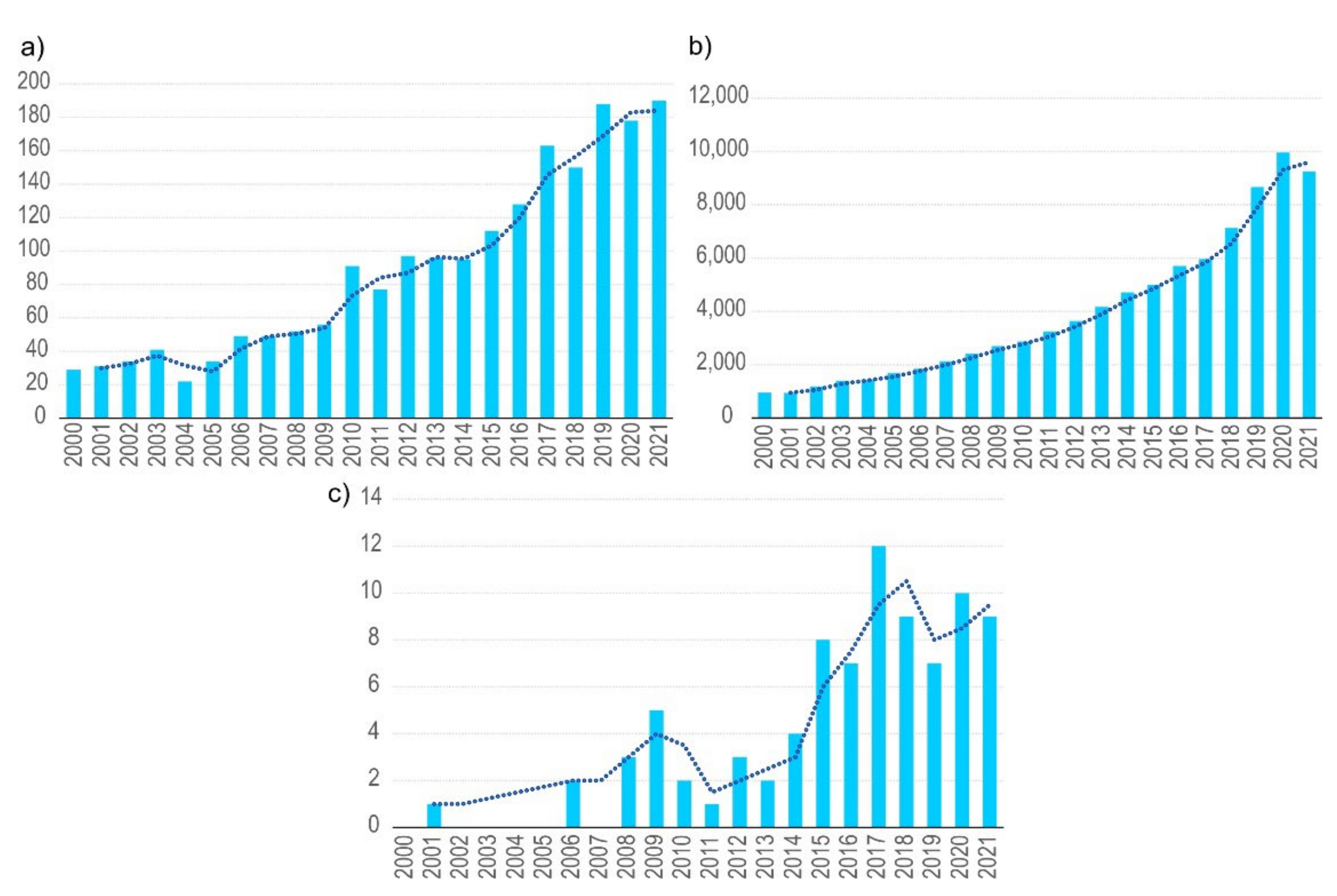

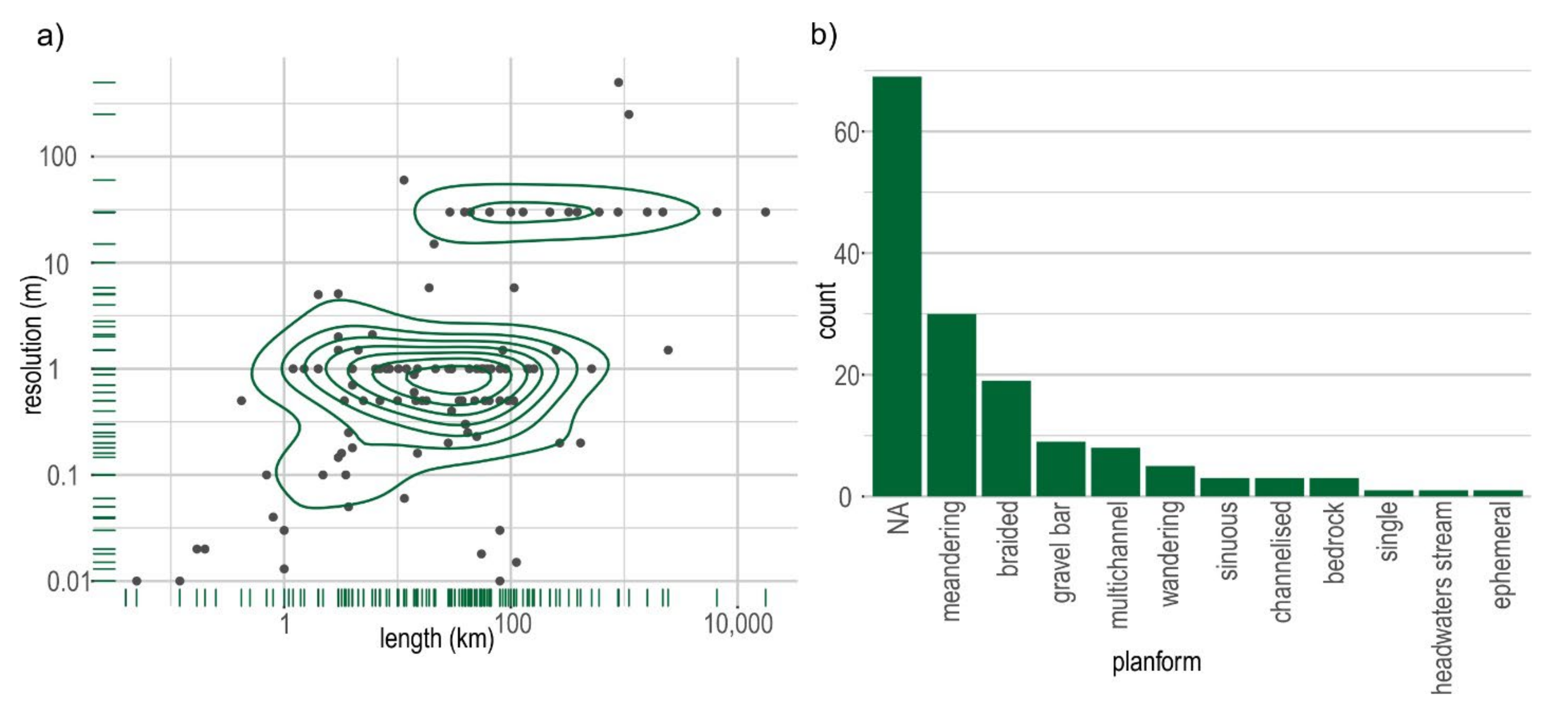


Publisher’s Note: MDPI stays neutral with regard to jurisdictional claims in published maps and institutional affiliations. |
© 2022 by the authors. Licensee MDPI, Basel, Switzerland. This article is an open access article distributed under the terms and conditions of the Creative Commons Attribution (CC BY) license (https://creativecommons.org/licenses/by/4.0/).
Share and Cite
Rusnák, M.; Goga, T.; Michaleje, L.; Šulc Michalková, M.; Máčka, Z.; Bertalan, L.; Kidová, A. Remote Sensing of Riparian Ecosystems. Remote Sens. 2022, 14, 2645. https://doi.org/10.3390/rs14112645
Rusnák M, Goga T, Michaleje L, Šulc Michalková M, Máčka Z, Bertalan L, Kidová A. Remote Sensing of Riparian Ecosystems. Remote Sensing. 2022; 14(11):2645. https://doi.org/10.3390/rs14112645
Chicago/Turabian StyleRusnák, Miloš, Tomáš Goga, Lukáš Michaleje, Monika Šulc Michalková, Zdeněk Máčka, László Bertalan, and Anna Kidová. 2022. "Remote Sensing of Riparian Ecosystems" Remote Sensing 14, no. 11: 2645. https://doi.org/10.3390/rs14112645
APA StyleRusnák, M., Goga, T., Michaleje, L., Šulc Michalková, M., Máčka, Z., Bertalan, L., & Kidová, A. (2022). Remote Sensing of Riparian Ecosystems. Remote Sensing, 14(11), 2645. https://doi.org/10.3390/rs14112645