Article

Application of Geophysical Methods in Archaeological Survey of Early Medieval Fortifications

1
Department of Archaeology and Museology, Faculty of Arts, Masaryk University, Arna Nováka 1/1, 602 00 Brno, Czech Republic
2
Archaeological Institute, Slovak Academy of Sciences, Akademická 2, 949 21 Nitra, Slovakia
*
Author to whom correspondence should be addressed.
Remote Sens. 2022, 14(10), 2471; https://doi.org/10.3390/rs14102471
Submission received: 13 April 2022 / Revised: 16 May 2022 / Accepted: 17 May 2022 / Published: 20 May 2022

Abstract

:
As powerful economic and cultural centers, fortified sites played an important role in early medieval society. In Central Europe, early medieval fortified site research has been an essential topic for several generations. However, gradual changes in the landscape are a threat to these cultural heritage monuments. The main task of this paper was to compare the previous results from archaeological excavations with new data acquired by geophysical methods. The presented study is based on the three methods widely used in archaeology: magnetometry, ground-penetrating radar, and electrical resistivity tomography. New surveys provide information about the internal structure and the state of preservation of the fortifications in a non-destructive way. Comparison of the results encourages the evaluation of archaeological excavation and helps determine the suitability and effectiveness of geophysical methods in specific natural conditions.

Graphical Abstract

1. Introduction

In archaeology, the investigation of fortified sites has a long tradition. Especially in Central Europe, early medieval fortified sites were one of the main topics of archaeological research for several decades. In former Czechoslovakia, they are closely connected with the origin and development of the Great Moravian Empire, which was in the political and scientific circles of the then communist regime, understood as the first common state of Czechs and Slovaks. Therefore, research on the Great Moravian fortifications as centres of power was generously supported financially, launching large-scale field research in the 1950s; which was one of the largest of its time in Europe [1].
For a long time, a geophysical survey has been a complementary method in the service of archaeological research. However, recent systematic incorporation of archaeogeophysics into several research projects has demonstrated that this method can provide more than just background data for archaeological projects. As a non-destructive approach archaeogeophysics can independently address topics related to the scope, nature, and state of preservation of past anthropogenic activities and remains in the landscape [2,3,4].
Today, we have a large amount of archaeological information regarding early medieval forts. These include data on fortifications, which demonstrate to contemporaries the importance of sites, as well as found evidence of how the structures acted as a defence against enemy forces. Almost all knowledge about the structure of ramparts came from archaeological excavations. So, what kind of new information, as well as additional benefits, can geophysical research bring to this topic? Firstly, it is possible to quickly examine individual segments of fortifications at incomparably low financial costs. Secondly, individual geophysical methods can monitor various physical properties of an investigated structure. We consider that the conclusions we reached in our research are valid for Early Medieval fortifications in the central Danube region and might also be applicable on a broader scale. These research results consist of a combination of wood, earth, stone, and techniques encountered in various parts of Europe from the Bronze Age to the High Middle Ages [5,6,7]. Therefore, our conclusions are valid for the presented sample sites from the Early Medieval times but can find application in different periods and regions where such fortifications occur.
There are two basic models of Early Medieval hillforts based on their position in the landscape: fortified hilltop settlements and fortified settlements situated on slightly elevated places in swampy areas in the floodplains of rivers. We do not know what led the builders to choose the location. Sometimes we find both types of forts close to each other (for example, Ducové and Pobedim in the valley of the river Váh in western Slovakia). The location of the fortified settlements on hilltops or in floodplains depends on environmental parameters, but can also reflect cultural choices ([8], pp. 63–66). From the point of view of our current research, two preliminary conclusions were drawn, which had to be verified: (i) Hillforts situated in a hilly environment have ramparts rich in stone material, and, at the same time, are relatively well preserved; (ii) On the other hand, hillforts situated in a lowland environment have ramparts that consist mainly of a wood-earth construction with a smaller number of stones. Due to agricultural activity, these sites tend to be, in principle, less preserved.
When classifying early medieval fortifications in Central Europe, we rely on Rudolf Procházka, who distinguishes two basic fortifications: simple and composed of several materials ([9], pp. 10–18, Figure 1). The first includes a moat, a rampart and a palisade. The second type has a combined wall consisting of wood, earth and sometimes stone elements, which can be interconnected or have various combinations. In the area of interest, we distinguish between the timber-laced and box rampart in terms of the wooden structure of the wall body. The most widespread types were walls with a front stone wall and a rear wooden wall, which were examined, for example, in Mikulčice [10], Břeclav-Pohansko [11], Majcichov [12], as well as in other sites. The widths of the fortifications range from one to nine m. In the case of ramparts with a front stone wall, most cases fit in the range of four to six m. The height of the ramparts ranged between 3.5 to 4.5 m ([9], p. 263). Today, we find remains of banks at the sites of such fortifications, which are often only a secondary manifestation of the destruction of the original ramparts. It is, therefore, necessary to distinguish between the terms rampart and bank: the first term generally refers to fortifications, while the second term can refer to both the original fortification and the destroyed rampart, which can be observed in the country in the form of a terrain ridge [13]. The question of how geophysical research can contribute to the knowledge of well or less well preserved remains of early medieval fortifications in the country will be addressed in this studyl generally summarising the results of intensive field research from 2018 to 2020, as well as numerous older findings.

2. Materials and Methods

In the purpose of examining the fortifications of early medieval hillforts by geophysical methods, we selected 10 sites which had been archaeologically studied in the past: Bíňa, Bojná, Břeclav-Pohansko, Brno-Staré Zámky, Dolní Věsonice-Vysoká zahrada, Majcichov, Mikulčice, Nejdek, Pobedim and Svätý Jur-Neštich (Figure 1, Table 1). Results of our geophysical prospections on three sites: Brno-Staré Zámky, Dolní Věsonice-Vysoká zahrada and Svätý Jur-Neštich have already been published in detail as case studies [14,15,16]. The remaining sites are presented here for the first time. The sites are situated in mountainous terrain as well as in the valley floodplains of rivers. According to reports from archaeological excavations the fortification walls were built only of earth and wood, as well as stone walls. There are hillforts, having walls which are still well preserved and traceable in the field, as well as hillforts that have been largely destroyed. Our task was to find out how these variable aspects are reflected in the results of individual geophysical methods. We applied three geophysical methods: electrical resistivity tomography (ERT), ground-penetrating radar (GPR), and magnetometry. Each method has its advantages and limitations, depending on the environment and the type of structure examined [17]. Combining various geophysical methods allows following a broader spectrum of physical properties of individual fortifications. All geophysical surveys were carried out close to areas that have been archaeologically explored in the past (Figure 2). This fact is an important advantage that enables us to compare the results from the geophysical survey with results from previous archaeological excavations.

2.1. Electrical Resistivity Tomography

The method of electrical resistivity measurement is the oldest geophysical method used in archaeological prospecting. The basic knowledge and procedures developed by geologist Conrad Schlumberger and physicist Frank Wenner in the early twentieth century are still used today [18]. Since the 1940s, after its first successful application in detecting archaeological structures, it has been used in the entire spectrum of archaeological research [3,19]. The electrical resistivity in a rocky environment is influenced by several factors, such as mineralogical composition, porosity, and water saturation. When searching for archaeological objects, the appropriate choice of electrode arrangement is also important. The Wenner, Schlumberger, and double dipole configurations are most commonly used for most archaeological applications [2,20]. For deeper research of buried archaeological objects, the application of measurement by electrical resistivity tomography (ERT) is applied [21,22,23]. A large number of electrodes is used in a line to obtain a cross-sectional image in the measured environment when performing ERT measurements. The measurement result is a 2D ERT profile representing the distribution of apparent electrical resistivity (Ωm) on the profile in horizontal and vertical directions [23,24].
Electrical resistivity tomography measurements at selected localities were performed with the ARES GF instrument (GF INSTRUMENTS) with a multi-electrode resistivity meter with 48 electrodes. In most cases, the lengths of the measured profiles were 47 m, in some cases 36 m and 73 m long. The spacing between the electrodes was 1 m, in some cases 0.5 m. The ERT survey was conducted in February 2019 at the end of the winter session when the moisture condition of the soil is convenient for the application of this method. All the ERT profiles were oriented outward of the fortified area. The beginning (zero) was always set on the inner side of the fortification. By comparison, measurements were performed in Wenner, Schlumberger and dipole-dipole configurations. The recorded ERT data were processed using the RES2DINV programme (Geotomo Inc., Houston, TX, USA) by applying the robust least-squares optimisation, using the standard least-square inversion methods and finite elements. The measured data were checked, and any extreme values were removed. The measured values of the apparent resistivity were converted to the actual values of the electrical resistivity by inversion. A topographic correction was applied. The final model represents the actual distribution of the measured apparent resistivity on the pseudo section.

2.2. Ground-Penetrating Radar

Ground-penetrating radar has long been one of the most commonly used geophysical methods for identifying subsurface structures in archaeology [25,26,27,28,29,30]. It belongs to the group of active geoelectric or electromagnetic methods. It is based on the repeated transmission of high-frequency electromagnetic pulses (up to 100,000/s) (from 10 MHz to 4 GHz) to the investigated environment and the feedback of their responses. It works on the principle of monitoring changes in physical quantities of the measured environment, i.e., material differences of the subsoil (permittivity) and specific resistances of individual layers (inhomogeneities).
For the GPR survey of the remains of the fortification elements, X3M Ramac georadar (Geoscience AB Malå) and two shielded antennae with a centre frequency of 250 and 500 MHz were used. The measured GPR profiles overlapped ERT profiles and had the same orientations. The interval of measured points was set to 0.1 m. Velocity was set on an average value of 0.1 m/ns suggested by the apparatus manual for unknown conditions. The lines of measurement were always situated perpendicular to the ramparts in the same places as the profiles examined using the ERT method. At all measured profiles, topographic data were collected by a total station at 1 m intervals. The data were processed in Rad Explorer software (Geoscience AB Malå). The standard and generally recommended processing steps were applied: subtraction mean (de-wow) filter, time-zero corrections, bandpass frequency filtering, gain adjustment, background removal and topography correction were calculated on the whole profile length. Bandpass frequency filtering, gain adjustment and background removal settings were chosen according to the needs of the individual case studies, and were adapted to give the best results for each individual measurement.

2.3. Magnetic Survey

Magnetometry is one of the most widely used geophysical methods for detecting and mapping archaeological sites [17]. Since the late 50s and the successful detection of burned structures in England [31,32], magnetometry has become a backbone of archaeogeophysical prospection. Magnetic survey is based on monitoring local variations of the Earth’s magnetic field. These inhomogeneities (magnetic anomalies) are caused by different ratios of ferromagnetic materials in monitored features and enclosing soil matrices [33,34,35,36]. The contrasts are generally associated with subsurface structures of various, but mainly geological, pedological, or anthropogenic, origins. Human activity in the environment would have caused either material accumulation or magnetisation. The most frequent magnetisation type is thermoremanent magnetisation, during which magnetically weak material becomes strongly magnetic. Based on this effect, archaeological features, such as kilns, ovens, furnaces, or objects filled with burned material, can be detected. The distinction between burned and unburned wall segments was also one of the main tasks of magnetic research.
Magnetic surveys on selected case studies were conducted with several types of magnetometers. Different setups of sensor arrays were implemented, based on the instruments’ availability and accessibility regarding the prospected areas. Surveys in Břeclav-Pohansko were conducted with a caesium magnetometer SM-5 Navmag (SCINTREX) in a vertical gradiometer configuration. The spatial resolution of collected data was 1 m (transect separation) by approximately 0.25 m (in-line). Magnetometers with three up to ten Ferex CON650 (FOERSTER) probes were used at the remaining locations. The horizontal separation of the probes was set up to 0.5 m. Data were collected every 0.25 m along with each measured profile. Data were processed and gridded in Eastern Atlas LEAD2 software or using the in-house developed script and Surfer 7 (Golden Software). Raw data were normalised with a median filter and drift correction was performed. Results of every magnetometry survey were interpolated in a 0.25 × 0.25 m raster. Interpretation and final visualisation were produced in ArcGIS 10.7 (ESRI).
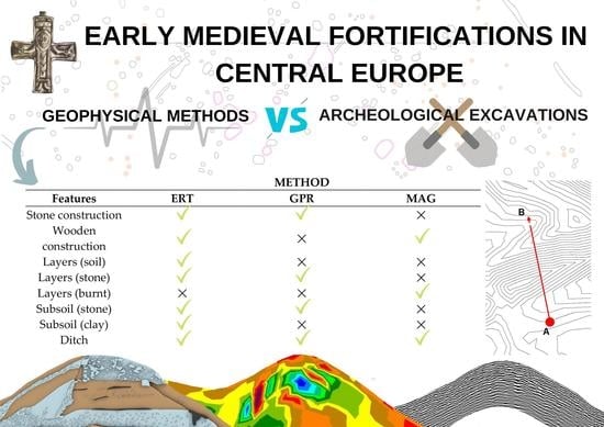
3. Results

3.1. Bíňa

With its area of 107 ha, the Bíňa hillfort was the largest fortified settlement of its time in Central Europe. It is exceptional and differs from other examined sites in terms of its fortifications’ size and character. The hillfort was protected by three simple loose ramparts of considerable dimensions. At the base, their width is around 16 to 28 m, with a height of around 8 to 9 m. The ramparts do not contain any internal structures that would hold the body of the embankment. The embankment material was obtained by digging a ditch. Therefore, the rampart’s core consists mainly of surface humus and the remaining part of sterile loess, which alternates irregularly with obliquely laid thin layers of sprinkled humus. A wooden palisade was probably placed on top of the rampart. The ditch is situated immediately in front of the rampart. It is partially clogged with soil from a gradually deteriorating rampart. Its bottom has a slightly rounded shape. It reaches a width of 10 to 22 m and its original depth was approximately 2 to 4 m (Figure 3A) [37].
GPR and ERT surveys were performed at the remains of the middle rampart. The GPR profile appears to be relatively homogeneous (Figure 3C). Only a few indistinct layers were captured, which can be interpreted as individual soil layers in the rampart’s bank (Figure 3D). The GPR profile shows that part of the bank has slid down into the ditch (Figure 3(Cb)). On the outside of the moat of the rampart, a smaller soil bank is visible, which has also partially slid into the ditch (Figure 3(Ca)).
The results of ERT show that the lowest central part of the rampart exhibits higher electrical resistivity values (Figure 3(Ba)). It is a material from the upper part of the original terrain from the ditch area in front of the rampart. This core is covered with a layer of low electrical resistivity values (Figure 3(Bb)), which makes most of the building material of the rampart. It was extracted from deeper layers composed of clay soil. The top layer of the rampart has higher electric resistivity values (Figure 3(Bc)). It is formed by sandy loess, which was extracted from the deepest layers of the frontal ditch. In addition to the main rampart, the remains of a less distinctive bank in front of the ditch are also visible (Figure 3(Bd)).
Due to the bushy vegetation, most of the rampart is inaccessible for magnetic research. The investigated segment on the eastern side of the outer rampart turned out to be significantly contaminated with recent iron scrap (broken wire fence). The wall itself showed low magnetic values. It consists of accumulated loess without internal stone or wooden structures that would succumb to heat. The finding fully corresponds to the results of older archaeological research [37].

3.2. Bojná I

Hillfort Bojná I (Valy), with about 12 ha, is situated on a forested promontory surrounded on three sides by steep slopes. To this day, the rampart remains exceed the surrounding terrain by about 6 m. A soil bank forms the outer line of the rampart, and it is preserved at the height of 90 to 100 cm and a width of 280 cm. The main fortification was separated by an excavated 380 cm wide ditch dug into the bedrock. The ditch was filled in two phases: at the bottom lay the remains of burnt wood and burnt stones, which collapsed at the time of the wall fire. The massive destruction in the upper part of the ditch backfill comes from the stone front wall that partially slid down to the ditch. The rampart was founded directly on a levelled bedrock and built of wooden log boxes filled with clay and stones. The boxes were laced with wooden grates. The front and back of the rampart were formed by a wall woven from branches held by a pair of wooden columns. A stone wall was built at the front of the rampart. A thick layer of large stones also covered the top of today’s preserved wall body. This layer originates from the crumbled frontal wall as well as from the top of the rampart’s surface (Figure 4A) ([38], pp. 20–23).
The GPR and ERT surveys were conducted in the northeastern part of the hillfort. On the outside of the rampart, the remains of the front stone wall could not be safely identified. Unfortunately, the GPR survey did not show any other interpretable anomalies.
In the results of ERT data, high electrical resistivity values in the lower layers of the central part of the wall body were detected (Figure 4(Ba)). This part is formed by stones surrounded by layers with lower resistivity values (Figure 4(Bb)). These values indicate that the soil consists of clay mixtures, which probably filled the space between wooden structures. The outer layer of the rampart shows higher resistivity (Figure 4(Bc)) and represents a layer with a high stone content. Anterior to the front ditch, which served as a source of building material during the construction of the rampart, a faint smaller soil bank is visible (Figure 4(Bd)).
As part of the project, no new magnetometric survey was performed on the Bojná site. For the project, the results of an older survey were used ([39], pp. 205–206), which was focused only on the inner space in front of the rampart in the northeastern part of the site. We can observe increased magnetic values related to burnt material in the magnetic data, especially stone, clay, and probably also partly wood.

3.3. Břeclav-Pohansko

Hillfort Pohansko is situated in the floodplain forest of the confluence of the Morava and Dyje rivers. The hillfort is divided into three primary areas. There is a central fortified part with an area of 28 ha and two baileys adjacent to it from the southwest and the northeast side. The rampart remains have been preserved in the shape of a bank around the main part of the hillfort. Numerous archaeological excavations have proved that the original rampart structure remained intact inside the bank up to a height of 2 m. The rampart was built of stone, clay, and wood. It was built on levelled original terrain and was about 7 m wide. On the outer side of the rampart was a sandstone face wall 1 to 1.5 m wide. Behind the stone wall remained the inner part of the clay wall reinforced with a wooden structure, mostly grate. It leaned against a rear wooden wall, secured by double pillars. On the top of the rampart a wooden walkway could be found. Traces of fire were recorded in places. According to the volume of destructed mass, the original height of the wall was estimated at up to 6 m. Today, the remains of the preserved rampart reach a height of about 2.5 m (Figure 5A) [11].
In the southern part of the hillfort, a place was selected for the research. The GPR survey succeeded in revealing the internal structure of the fortification body in the form of several inhomogeneous layers (Figure 5C,D). These are visible inside the rampart and on its outer side; probably the remains of a destruction layer of a front stone wall. However, the front stone wall itself cannot be unequivocally recognised.
In the results of ERT measurements, the rampart remains were manifested by alternating several layers with different electrical resistivity values. The lower central part of the rampart and its top layer was formed by a clayey filling, manifested by low electrical resistivity values (Figure 5(Ba)). The upper front part is characterised by higher electrical resistivity values (Figure 5(Bb)). This is soil with an admixture of stone and the remains of the front stone wall.
Compared to the surroundings, the fortification showed only slightly increased magnetic values (0.2–3 nT/m) on the magnetic map. It is not visible at all due to recent contamination by interfering elements. However, significant magnetic anomalies were also localised, reaching values above 250 nT/m (Figure 6A). During the surface inspection, several pieces of burnt daub were found, which document the local places of the fire.

3.4. Brno-Staré Zámky

The hillfort, with an area of about 13 ha, is situated on a distinctive rocky promontory. It consists of the central acropolis located in the southeast with two baileys attached on the northwest side. The object of interest of geophysical prospecting was the fortification of the acropolis. Today, the rampart is almost completely eroded and has the shape of a low terrain wave. In archaeological research, foundations of a stone wall approximately 1 m wide were documented. A substantial part of it collapsed down the slope. Log boxes filled with clay were adjoined from the inner side of the rampart. A ramp made of piled-up clay was also connected to the structure from its inner side. The construction of the fortification dates to the 9th century. At the beginning of the 10th century, the foundation of a dry-laid stone wall, which forms a part of the younger wall, was embedded in the then destroyed fortification (Figure 7A) ([9], pp. 152, 155, Figure 95).
The main task of the GPR and the ERT was to ascertain the state of preservation of today’s almost invisible fortification in the field. The GPR survey captured homogeneous layers that can be interpreted as remains of the body of the wall (Figure 7C,D). No stone structures could be identified in the GPR results. The anomaly with higher electrical resistivity values measured with ERT represents the remnants of the original stone-rich fortification (Figure 7(Ba)). At the same time, it is possible to observe the destruction layer spread down the slope (Figure 7(Bb)). Therefore, the ERT survey fully corresponded with the results obtained from archaeological research.
In the magnetic data, the rampart remains visible as a linear anomaly with high magnetic values (20–100 nT/m), indicating high heat (Figure 6B). This fully corresponds with the findings from archaeological excavations, which showed that at the turn of the 9th and 10th centuries, the perimeter wall of the acropolis experienced a large fire, and in some places it was utterly destroyed. This is evidenced by burnt wooden grates as well as a layer of burnt clay up to 1 m thick ([9], p. 155, [40], 155, [41], p. 201).

3.5. Dolní Věstonice—Vysoká zahrada

The Dolní Věstonice—Vysoká zahrada hillfort (1.3 ha) is located in the lowlands on the former left bank of the Dyje river. Archaeological research has shown a complex profile in which strongly fired layers alternated with unfired clays. Between these layers, the burnt wood from the log boxes of the wooden wall structure was observed. Also, in the burnt state, a massive wooden wall from the back wall of the fortification was preserved. The finding makes it possible to reconstruct the original wall of a wooden structure filled with clay. Scattered stone material was also found in small amounts. The front stone wall was not documented during the archaeological excavations (Figure 8A) [42].
GPR and ERT surveys were done on the north side of the hillfort’s fortification. Inhomogeneous layers, probably formed only by soil, were identified on the GPR profile along its entire length. A noticeable homogeneous layer can also be found on the outer side of the rampart remains, which falls downwards and could be related to the rampart’s destruction (Figure 8C,D). The GPR survey did not identify the remains of the ditch, possibly due to soil humidity.
In ERT measurements, the bank’s upper and front parts have higher electrical resistivity values (Figure 8(Ba)) than the central and lower parts of the rampart. This is probably due to sandy soil with a possible mixture of stone. In the lower part, the area is made of a material with very low resistance values (Figure 8(Bb)). These may be remnants of the original timber structure filled with clay.
Compared to its surroundings, the rampart has higher magnetic values (around 200 nT/m) on the magnetic map (Figure 6C). It is proof that the wall was subjected to the destructive effects of fire, probably in its entirety and not only in the section examined by archaeological excavation. Equally high magnetic values were shown in the area in front of the fortification, where we can expect layers of the destroyed rampart. The surrounding terrain showed low magnetic values (0–0.2 nT/m).

3.6. Majcichov

With an area of 6.6 ha, this lowland hillfort is located on long-term and agriculturally managed fields near the confluence of the Dudváh and Trnávka rivers. Archaeological research of the fortification has documented the existence of a ditch and a wooden box rampart filled with clay and a stone wall in the front ([12], pp. 222–225). From the edge of the ditch, the lower part of the wall is formed by a base grate, consisting of approximately 5 m long logs, laid side by side perpendicularly to the course of the rampart. Above the grate was an approximately 20 cm thick layer of clayey soil on which the front stone wall was built. It consisted of dry-laid stones and reached a width of 0.85 to 1.1 m. The captured widths and lengths of the wooden boxes are from about 3.8 m to 4.9 m. From the inside, the structure was strengthened by massive wooden pillars. The inner filling of the wooden boxes was made of clayey soil originating from an excavated ditch (Figure 9A).
GPR and ERT surveys were carried out on the remains of the rampart on the northwest side of the fortified settlement. Unfortunately, the rampart remains were almost entirely plowed and leveled with the surrounding terrain due to intensive agricultural activity. This situation was significantly reflected in the results of the GPR survey. On the measured profile it was possible to identify several significant inhomogeneous layers in the places of the fortification, which can be related to the body of the rampart. However, it is not possible to distinguish the remains of stone structures in the results (Figure 9C,D).
In the ERT profiles, the rampart remains are visible, with a width of approximately 10–15 m. Low electrical resistivity values (Figure 9(Ba)) were measured at the rampart base. This area is probably a manifestation of the original base grate with a clay layer. The rampart bank has medium to higher values (Figure 9(Bb)) compared to its surroundings. It is made of soil and subsoil material, such as gravel and stones. The ditch, dug into the subsoil, had the lowest electrical resistivity values, and is located in front of the rampart (Figure 9(Bc)).
The rampart remains are very well observable on the magnetic map. As a result of the fortification having burned down, the wooden box structure is distinguished by its high magnetic values (10–300 nT/m), while the clay soils from the inner filling of the boxes and the remnants of the stone front wall show slightly lower magnetic values (Figure 6D). The ditch into which the burnt rampart collapsed also shows high magnetic values. The rampart and ditch appear only as parallel lines with low magnetic values (0.1 nT/m) in parts where the wall did not burn.

3.7. Mikulčice-Valy

The fortified settlement Mikulčice is located in a lowland area of floodplain forests on the right side of the Morava River. The fortified area is approximately 10 ha and consists of the central acropolis and one bailey on the northwest. The main fortification of the acropolis in Mikulčice consisted of a 1.5–2 m wide stone wall and a reinforcement of a one-way grate made of layers of densely laid logs at intervals of 0.5–0.7 m. Wooden pillars held the rear wooden wall. The inner filling consisted mainly of clay. The total width of the rampart was about 7 m. The height of the rampart can be estimated at 4–4.5 m, based on the volume of rubble. The preserved rampart has a height of about 2.5 m, while the intact front wall is preserved to a height of about 0.4 m. In many places, the rampart has been disturbed by the later removal of stone. Archaeological excavations proved that the fortification system in Mikulčice ingeniously used the natural protection of the Morava watercourse. In front of the wall, 1 m lower and 3 m further, a stone wall was supported by rows of wooden pillars. Adjacent to the face of the wall were flood soils and clays, on which the destruction of stones from the upper wall was resting (Figure 10A) [43].
GPR and ERT surveys of the fortification remains were performed in the southwestern part of the acropolis. The GPR survey revealed a sequence of inhomogeneous layers forming the internal structure of the rampart (Figure 10C,D). Unfortunately, the front stone wall remains cannot be recognised in the obtained radarogram. It is evident in the profile that part of the bank has fallen into a terrain depression outside of the rampart, which could be interpreted as an extinct river arm (Figure 10D).
In ERT results, the upper part of the rampart has higher electrical resistivity values for the most part (Figure 10(Ba)), representing sandy soil with stones, which are a manifestation of the stone filling, the remains of the front wall and its destruction. Under it is a layer of low resistivity values, due to a material made of clay (Figure 10(Bb)). An interruption is visible on the inside of the rampart in approximately one-third of the bank (Figure 10(Bc)). It may be a sign of the original wooden grate structure.
Some parts of the wall did not show up at all in the magnetic data. Where the fortification is visible on the magnetic map, the rampart’s core appears as a negative magnetic band approximately 5 m wide. It is lined on both sides with magnetically positive lines (Figure 6E). We could interpret the identified structures as remains of a front and rear wall (stone and wooden construction) with positive magnetic values and a core formed by a compact clay backfill with slightly negative values. The wooden structural elements inside the bank did not show any effect during the magnetic survey. The total thickness of the wall on the magnetic map is 7 to 8 m.

3.8. Nejdek

This lowland hillfort of an approximate area of 6 ha lies in the floodplain forest surrounded by distributary channels of the river Dyje. It consists of the main fortified area and two additional ramparts in the south and the east. Today, the rampart destruction in the shape of a bank is about 15 m wide and 2 to 3 m high. Previous excavation proved that a clay modification with a thickness of 0.2–0.5 m, which exceeded the ramparts on both sides, was placed on the soil horizon. Above it, it was possible to distinguish between a core 5.5 m wide (originally 4 m) and, in the front part, a block of stones 2.3 m wide (originally 1.7 m) and 0.7 to 0.8 m high, mixed with clay. The original height of the wall is estimated at 3.5 m. In the Middle Ages or modern times, stone mining significantly disturbed the rampart (Figure 11A) [44,45].
GPR and ERT surveys focused on the rampart in the northwestern part of the central area. The GPR results showed inhomogeneous layers related to the rampart’s internal structure (Figure 11C,D). The character of the layers identified on the outside of the rampart could indicate the presence of stone destruction (Figure 11(Ca)). The already silted outer ditch remains were also visible (Figure 11(Cb)).
In ERT results, higher electrical resistivity values were measured in the outer upper part of the rampart (Figure 11(Ba)). It is a soil material with a stone content. The layer below it has lower resistance values (Figure 11(Bb)). It probably consists of a clay layer, the original base of the rampart. In the inner third of the bank, a narrower vertical anomaly is visible (Figure 11(Bc)), the origin of which is unknown to us. It could signify the original wooden construction in this part of the rampart. In front of the rampart, a shallower indistinct ditch with a filling with lower electrical resistivity values is visible (Figure 11(Bd)).
A magnetometry survey, which could provide information on the structure and the extinction of the wall, could not be carried out due to the dense vegetation on the site. One measured profile indicates slightly increased magnetic values in the bank area, which do not show traces of fire.

3.9. Pobedim

This two-part hillfort is situated in lowland, long-term agricultural fields in the Nive valley between the Dudváh and Dubová rivers. The fortification was formed by a wooden box rampart filled with clay, which defined an area of about 8 ha. The individual wooden boxes reach a side width of 3 to 4 m. The inner wooden wall of the rampart was secured with obliquely recessed pillar abutments. The outer wall was made of dry-laid stones. In front of the rampart was another defensive element—a ditch. Due to intensive ploughing, the rampart has been preserved only in its lowest part. Thus, only the foundation parts of the front stone wall and the wooden box structure were archaeologically examined (Figure 12A) [46].
The GPR and ERT surveys were carried out on the rampart separating the acropolis from the bailey. An inhomogeneous layer about 6 m wide was identified on the GPR radarogram, probably the remains of a rampart (Figure 12(C,Da)). The GPR survey did not identify the remains of the ditch. The results of the ERT measurement did not detect any apparent anomaly that would indicate the presence of a rampart. Only a slight appearance is present in the data (Figure 12B). The situation resulted from intensive agricultural activity, which significantly disrupted the rampart’s original construction.
On the magnetic map, individual burnt wooden boxes manifested themselves as a lattice structure with negative magnetic values, and ditches filled with material with higher magnetic values are visible in some places (Figure 6F). Most of the fortification shows only slightly positive magnetic values.

3.10. Svätý Jur—Neštich

The hillfort is located on the forested mountain promontory of the Little Carpathians. It consists of the main castle to which two baileys (I and II) adjoin from the northwest. The total area of the fort is 8.5 ha.

3.10.1. Fortification of the Main Castle

The fortification of the site is well preserved. The height of the rampart is 11 m in some places. A ditch surrounds the hillfort on the outer and inner sides, while the outer side was designed to increase defence effectiveness, and the inner side was created as a secondary element in the construction of ramparts. The wall construction consisted of 3.5–4 m long transverse beams stacked in four layers between 0.9 m and 2.5 m deep. This structure was covered with clay with an admixture of stones. The whole construction was connected to the frontal stone wall (Figure 13A) ([4], pp. 70,88,91).
GPR and ERT measurements were performed in the northwestern part of the acropolis. GPR research identified a significant formation connected to the rampart body. Horizontal layers illustrate the parts where the original rampart is still preserved (Figure 13(C,Da)). Significant reflections were also documented on the front side of the rampart (Figure 13(C,Db)) and inside the ditches (Figure 13(C,Dc)). They indicate that stone, as a building material, is significantly present in the rampart structure.
In ERT data, the whole rampart is manifested by higher electrical resistivity, while on its central and frontal side, anomalies consist of a material with the highest resistivity values (above 10,000 Ωm). The high resistivity values represent the stone filling in the rampart construction (Figure 13(Ba)). The high resistivity in the lower level of the frontal part of the rampart can be interpreted as a destroyed section of the frontal stone wall of the rampart (Figure 13(Bb)). A high number of stones is also present in the filling of the frontal ditch (Figure 13(Bc)), which also exhibits a significantly higher resistance value. The filling of the ditch behind the wall does not exhibit such high values (Figure 13(Bd)). It was filled by the destruction of the back wall of the rampart, which was not a stone wall. The survey results also show that both ditches reach the subsoil (Figure 13(Be)).
Magnetic measurements on the rampart were not performed, due to the unavailability of the terrain for the area surveyed.

3.10.2. Fortification of Bailey II

The rampart on bailey II has a different internal structure than the main hillfort wall and was built in a slightly later period. It manifests itself only as a low elevation running parallel to the moat located immediately in front of it. Archaeological research has shown that the fortification of bailey II was only a simple rampart without any inner construction elements (Figure 14A) ([48], pp. 55–59).
The GPR and ERT surveys were conducted in the northeast part of the bailey. Several horizontal layers can be recognised in the vertical GPR time/depth slices. The rampart itself appears to be covered by a thick clay layer of a few tens of centimetres (Figure 14(C,Da)). There are no significant anomalies visible inside the rampart body. GPR survey shows that the ditch itself is probably filled with less contrastive material than its surroundings—for example, only soil (Figure 14(C,Db)).
The results of the ERT survey confirmed the results of the GPR research. Higher electrical resistivity values were detected in the upper part of the outer half of the rampart (Figure 14(Ba)), which might be a result of a more extensive amount of stone debris present in the area. However, the investigated rampart consists of clay soil excavated mainly from the outer ditch.
Magnetic measurements covered a small segment of the fortification in its eastern part. Only slightly increased magnetic values were recorded, which fully correspond to the fact that the rampart was a simple bank.

4. Discussion

The range of basic geophysical measurements, which were used for the first time to such an extent to solve the specific archaeological problems of the early medieval ramparts, offers many topics for discussion. Although we work with physically measurable quantities and the results of measurements can be expressed in the form of precisely defined values, factors such as short-term or long-term climatic conditions significantly affect the final interpretation [49,50,51], as well as the experience and knowledge of the surveyor [4,35], or the instruments and software used [52,53]. Archaeological interpretation of geophysical data is therefore never entirely objective. Nevertheless, given the quantity of available data, it is possible to monitor trends that could be described as generally valid (Table 2).
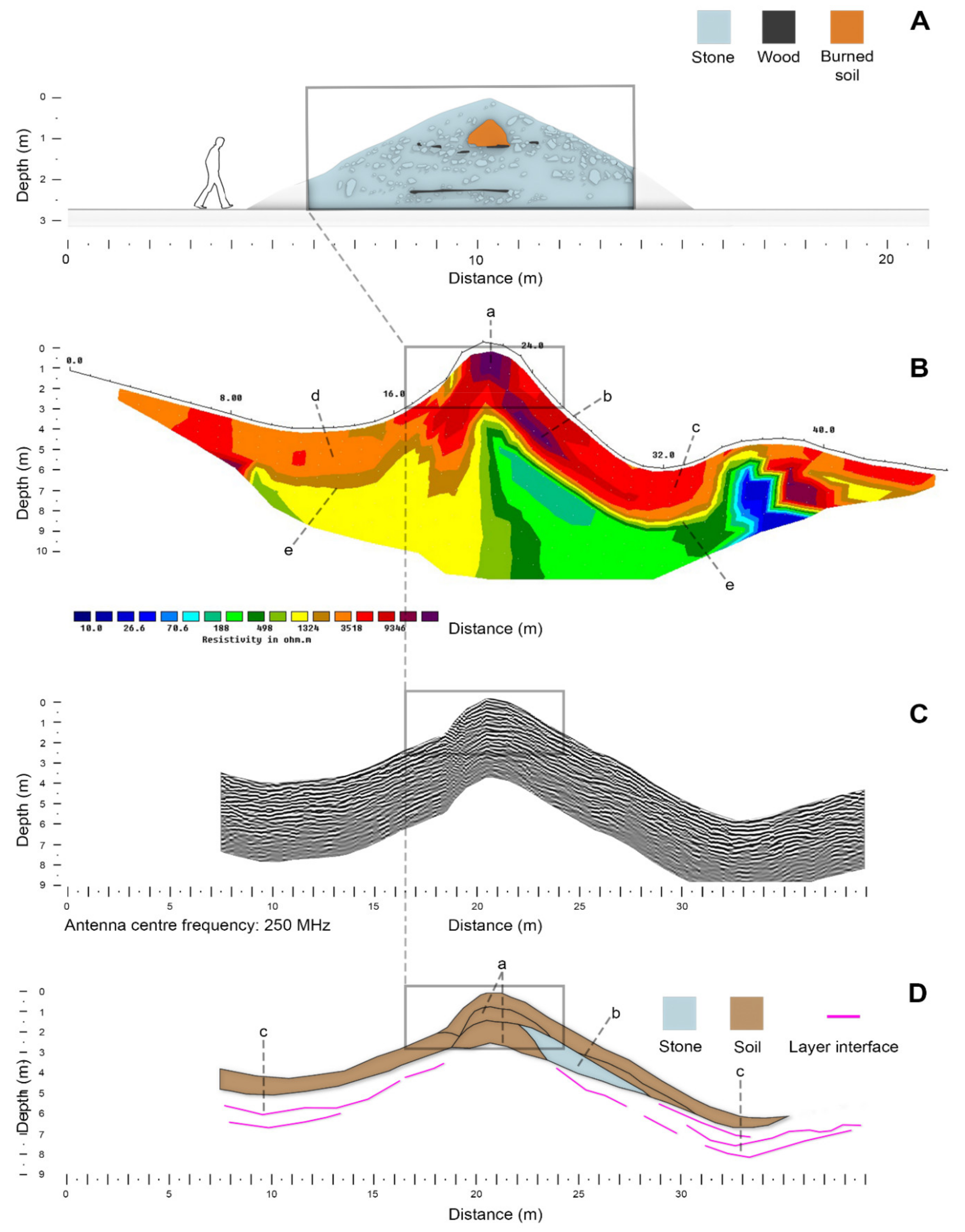
In determining the materials of which the examined ramparts consist, ERT was the most effective of all three methods implemented. The recorded results of ERT measurements often offer a surprisingly detailed picture of the internal structure of the rampart and ditch fillings. The measured values of the ERT data reflected the type of construction material used, which depended on local resources. There is apparent difference between fortified hillfort and lowland settlements. Based on the electrical resistivity values (1000 Ωm and more), the stone features of the ramparts were clearly recognisable. The largest share of the stone component is shown by the remains of the fortifications at the Svätý Jur—Neštich (Figure 13B) and Bojná (Figure 4B) hillforts. Both sites are located in a mountainous environment; therefore, the stone did not have to be imported. During the process of digging a ditch, a large amount of stone was mined, which was subsequently used not only for building the front wall but also as a filling of the rampart’s bodies. In particular, the Neštich hillfort is an excellent example, with a compact structure in the central part and on the front side of the rampart, which is a manifestation of the rich representation of stone rubble in the filling of the rampart’s body and the destruction layer coming out from the front stone wall. The ERT measurements at both sites fully correspond to the results of archaeological research ([38], pp. 20–23, [54], pp. 70–91). The ability of ERT to detect frontal stone walls in ramparts with wooden structures filled with soil can also be described as successful. In accordance with the results of archaeological excavations ([10], pp. 128–131, [
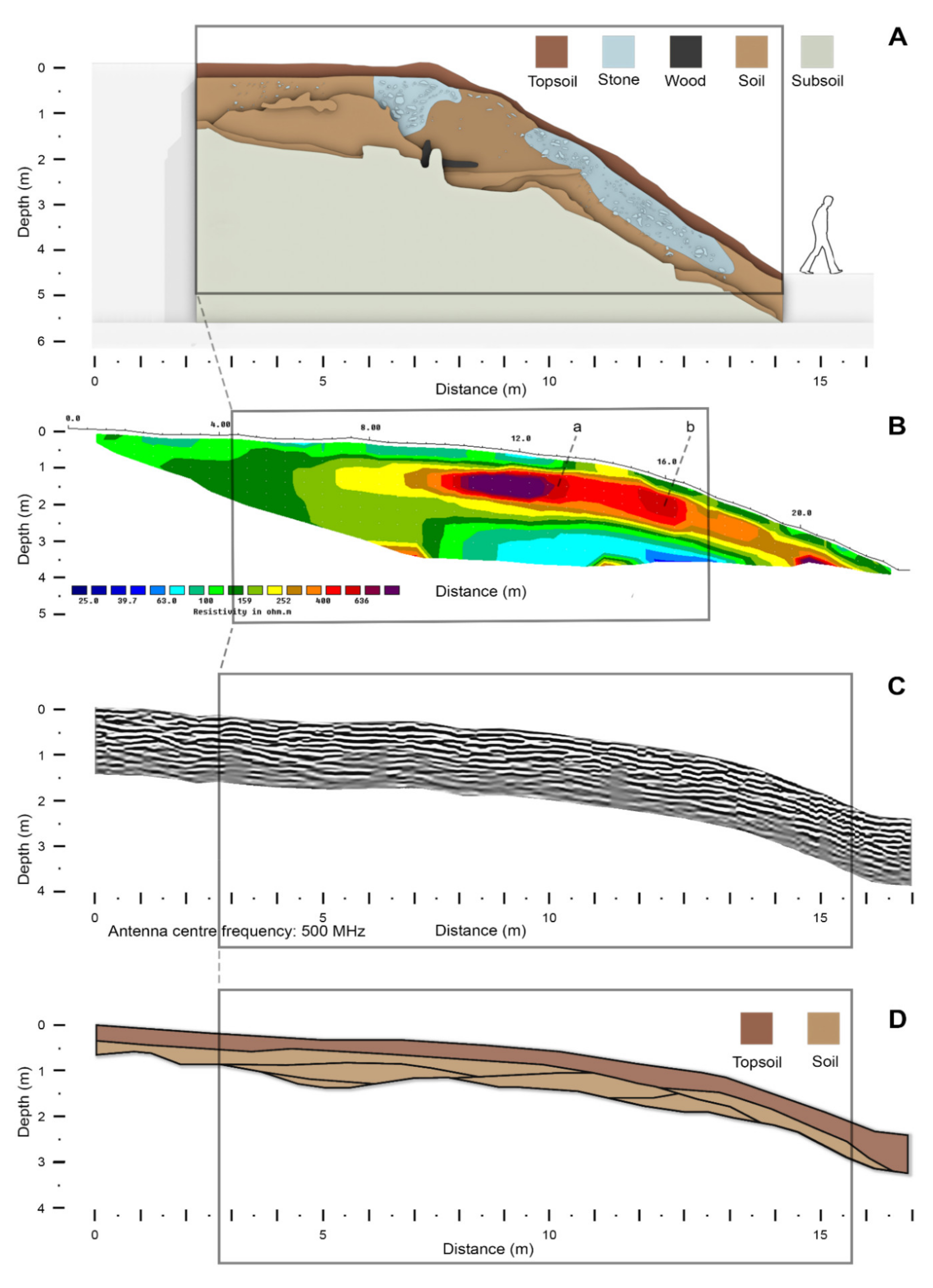
11]), the remains of the frontal stone walls were identified based on higher values of electrical resistance (approx. 300 Ωm—in comparison with the surroundings, characterised by values of approx. 30 to 50 Ωm) and their destruction layers at the hillforts of Břeclav-Pohansko (Figure 5B) and Mikulčice (Figure 10B).
GPR is generally considered an ideal method for detecting stone structures [26,27,28]. In this case, we assumed its high informative value in identifying the stone features of the ramparts. However, the reality was different. The results of GPR surveys did not provide as differentiated an image of the internal structure of the ramparts as we expected. Numerous inhomogeneities, proving a high proportion of stone, were observed at the site of Svätý Jur—Neštich (Figure 13C,D) and Bojná (Figure 4C,D). Also, on the radarograms ditch fillings that contained stone material were quite visible. However, the distinction of individual archaeological structures from the geological subsoil was relatively complicated at both sites. Nevertheless, it was impossible to fully distinguish the stone component even in Břeclav-Pohansko (Figure 5C,D) and Mikulčice (Figure 10C,D), where the front walls and their destruction are surrounded mainly by clay backfill.
The magnetic survey recorded zero success in detecting stone elements of fortifications. It should be noted that the magnetic survey was only marginally done on the sites with stone-rich ramparts, such as Bojná and Svätý Jur—Neštich. The front stone wall could not be detected anywhere—not even on the sites where it is well preserved, such as in Břeclav-Pohansko (Figure 6A). The reason is the character of the material used for construction. In our conditions, it is limestone, which does not differ significantly from its surrounding magnetic values. Usually, objects built of limestone appear as magnetically negative structures. However, this is not the case with the examined early medieval ramparts. This phenomenon occurs due to the stone walls being significantly destroyed, and even in cases where their parts are intact, they are surrounded by destroyed clay-stone layers. The same results have been reached in the surrounding regions [55,56].
Geophysical methods also point to differences in the ramparts’ soil composition, particularly in the results of the GPR surveys, which indicates two indistinct layers in otherwise homogenous radarograms. The differences in soil composition in the results of ERT measurements are most significant. For example, in the remains of ramparts in Bíňa (Figure 3B) and Dolní Věstonice (Figure 8B), it was possible to distinguish the humus layers from the loess layers or the sandy outer layer from the clay core. In Bíňa, it was also possible to rule out the occurrence of stone in the backfill. Magnetic research has not brought new knowledge to this issue.
An essential structural element of fortifications is their wooden features in the form of log boxes or gratings. Their detection by GPR or ERT is problematic due to the poor state of their preservation. Their presence can only be demonstrated indirectly. Anomalous zones point them out with low values of electrical resistivity, related to the fillings of wooden structures—observed in Bojná, Dolní Věstonice, Majcichov, Nejdek, and Svätý Jur. However, it should be emphasised that our interpretation of geophysical data would not be so clear without knowing of the presence of wooden structural elements in the ramparts.
The best results were obtained by magnetometry, especially in ramparts where wooden structures were located near the surface. The existence of a rear supporting wooden wall of the rampart was found in Břeclav-Pohansko (Figure 6A). It was well detected in the data because the wall burned down. Several significant magnetic anomalies were also located here, reaching values above 250 nT/m. We can follow traces of fire here, which engulfed the original wood-clay rampart in the given segments. Archaeological research also documented wooden tunnels inside the rampart to ascend to the gallery ([11], pp. 104–106; Figures 117–121). Interestingly, such anomalies occur at regular 15 to 20 m intervals on the magnetic map. Therefore, we can assume that these are evenly spaced wooden reinforcements of the tunnel system.
Since the fortification burned down, the wooden chamber construction excelled with its high magnetic values (10–300 nT/m) in Majcichov (Figure 6D) and Pobedim (Figure 6F). Interestingly, in some sections of these two hillforts, it was possible to distinguish individual wooden boxes, even in the unburned parts of the rampart. We can observe very weak negative anomalies in the magnetic data, interpreted as the front and rear walls and partitions of wooden boxes. The ramparts did not burn here, and the inner wooden box structures, and the soil with which the boxes were filled, were not permanently magnetised. The opposite effect was observed with the parts of the rampart that were subject to fire. The wooden structures here gradually fell apart. The clay material used to build the rampart and the filling of wooden boxes naturally show slightly higher magnetic values than the wooden parts of the fortification. These can then be observed as slightly negative anomalies (−0.1 nT/m). In both cases, the survey results coincide with the findings of previous archaeological research [12,46].
From geophysical data, we can determine one way the functionality of the ramparts was extinguished, even in cases where the fortification burns down. As mentioned above, traces of an intense fire in the wooden structures of the ramparts were detected in several investigated sites (Břeclav-Pohansko, Majcichov, Pobedim). Traces of fire in the form of burnt wood-clay banks (Bojná, Brno-Staré Zámky, Dolní Věstonice) were also registered on other sites. It turns out that destructive flames affected most of the early medieval hillforts in the central Danube region. This finding confirms and expands existing knowledge from archaeological research [57]. At the same time, it has been shown that magnetometry can provide the best indications for research into this phenomenon.
The natural environment and terrain conditions are important factors in assessing the results of geophysical surveys. Individual methods can be challenged by the conditions of forest versus open landscape. The advantage of open terrain applies to all methods. The electrical method has the smallest deficit in the forest environment, while dense growth is an obstacle in geo-radar survey and magnetometry. The same conclusion applies when taking into account complex topographic relief. While in the magnetic and geo-radar survey inaccuracies in the measurement results must be taken into account, despite postprocessing of the data, in ERT, this phenomenon did not manifest itself, due to the secondary application of field corrections (this is especially true for measurements with Wenner and Schlumberger configurations).
The rock character of the subsoil and the material composition of the rampart has a more significant influence, than the character of terrain, on measurement results [2,58]. The most suitable measuring media for ERT and GPR methods is generally composed of contrasting and well-distinguishable materials. In the survey of early medieval hillforts, it was possible to apply these methods well to those ramparts for which stone was used as one of the building materials. Thanks to its different physical properties, it can be well distinguished from the surrounding clay soils. In these cases, it is mainly a matter of detecting the destruction of front stone walls. In our case, the magnetometric measurements were not significantly affected by the rocky environment. However, in the lowlands, where the environment is composed of river sediments, the sections of the ramparts (untouched by fire) are less pronounced than in sites located in higher positions, where the ramparts are made of more magnetic rock materials.
The informative value of the geophysical survey significantly depends on the preservation of the fortification, which is closely linked to the location of the site and the activities that took place on it. The state of preservation of the fortifications is most reflected in long-term intensive agricultural activity, which in most cases is mainly related to sites in the lowlands. The destructive layers have a negative effect on the readability of the data, especially in GPR surveys. On the contrary, magnetometry can benefit from poor rampart preservation. For example, on relatively intact ramparts, it is impossible to monitor the ramparts’ internal structures in detail, and definitely not as much as is possible on the largely ploughed and surface-exposed structures in the Majcichov and Pobedim sites. Even though it was not the task of the presented research, we can say in general that the main advantages of magnetometry include the ability to quickly and accurately detect invisible, or hard to recognise, fortifications in the field, such as palisade troughs, clogged ditches, or wholly destroyed ramparts. On the contrary, the geophysical survey contributes to important findings concerning preservation of the fortifications on individual sections of the ramparts. This plays a vital role in planning field archaeological work or monument conservation cases [59].
An important parameter in any survey is the correctly chosen methodology. The methodology chosen by us has its weaknesses in evaluating and comparing the obtained data. We relied on surveys based on individual profiles with ERT and GPR methods, but it would be more appropriate to focus on surveys based on whole areas. However, due to the dense vegetation and challenging terrain, such surveys could not be carried out in most of the studied sites. Despite the chosen methodology, both methods enabled vertical penetration into the ramparts’ cores and, in comparison with magnetometry, brought a whole range of information. On the contrary, magnetometry proved to be highly effective in area measurements, where it was possible to observe spatial relationships at the horizontal level.
Regarding the complexity of measurements and the financial and time factors, what type of method should be implement in the case of research into early medieval fortifications in the future? A straightforward answer to such a question cannot be given. It always depends on many variables, among other things on research tasks, state of sites, and parameters of the available technical equipment. However, we have concluded that ERT appears to be the optimal method for well-preserved remains of fortifications. Thus, we were able to record situations (layers and destructions inside the bodies of the ramparts, the level of the subsoil, ditches) in all surveyed sites, which corresponded to the findings from archaeological excavations. The GPR survey—especially by individual profiles—is more time-saving in the preparation and measurement process. While it takes a few minutes to measure one GPR profile, it takes approximately one hour to measure one ERT profile. However, the interpretation of the GPR data turned out to be significantly more complicated and, at the same time, less convincing. The advantage of magnetometry is less complexity in performing measurements and interpreting data. However, magnetometry did not provide any essential information, other than the ability to identify burnt-out parts of the ramparts on well-preserved ramparts.
On the contrary, with significantly levelled fortifications, it was possible to record the internal wooden structures on the unburned parts by magnetometry. However, it was possible to reach the given results only by areal magnetometric surveys. Last but not least, the possibility of potential contamination of the investigated areas with recent disturbing elements should be mentioned. These can negatively affect the magnetic survey results, as was the case, for example, at the Bíňa fortified settlement. In such cases, ERT and geo-radar surveys are less affected by the environment. Therefore, if possible, it is advisable to use a combination of at least two methods.

5. Conclusions

Ten early medieval hillforts were selected to examine fortifications by geophysical survey. Three of the most used methods in archaeogeophysics were applied: electrical resistivity tomography (ERT), ground-penetrating radar (GPR), and magnetometry. Overall, we can say that the range of results achieved on individual ramparts is well above expectations. Several structural features were identified in detail in several ramparts by combining individual methods.
The ERT method documented numerous inhomogeneities at individual fortifications, which point to different construction materials, different intensities of their use, and the state of preservation of the ramparts. In several cases, it was possible to determine the original levels of the terrain, the stone and clay cores of the ramparts, and the extent of the destruction of the stone walls.
The GPR method is generally suitable for identifying stone structures and determining different materials and layers. Nevertheless, a survey of the early medieval ramparts did not yield the expected results. With a high degree of reliability, it was possible to identify ditches and their differentiated backfill. Some structural features inside the ramparts, especially their stone parts, were only identified thanks to our knowledge of specific situations from past archaeological excavations.
Magnetometry has proven to be an ideal method for researching fortifications preserved by torsion. Here, it was mainly possible to identify the wooden parts of the walls and identify the areas affected by fire.
The results of the performed geophysical surveys have not been verified by archaeological research. Nevertheless, we consider our interpretations to be highly credible. All surveys were carried out in the vicinity of past archaeological excavations. Geophysics and archaeology could therefore be directly confronted and compared. Another important fact is that the conclusions we reached in our research are not only valid for early medieval fortifications in the central Danube region. Fortifications built with a combination of wood, earth, and stone represent a supra-regional phenomenon, evidenced in different periods. Therefore, the findings presented in this study can be used to study a wide range of fortifications, taking into account local conditions.

Author Contributions

Conceptualisation, P.M., M.V., T.T. and I.M.; methodology, P.M., M.V., T.T. and I.M.; software, P.M., M.V., T.T. and I.M.; validation, P.M., M.V., T.T. and I.M.; formal analysis, P.M.; investigation, P.M., M.V., T.T. and I.M.; resources, P.M.; data curation, P.M., M.V., T.T. and I.M.; writing—original draft preparation, P.M., M.V., T.T. and I.M.; writing—review and editing, P.M. and M.V.; visualisation, P.M., M.V., T.T. and I.M.; supervision, P.M.; project administration, P.M.; funding acquisition, P.M. All authors have read and agreed to the published version of the manuscript.

Funding

This research was funded by the Czech Science Foundation (GA CR) under Grant No. 18-16153S “Early Medieval hillforts in the light of non-destructive investigation”.

Data Availability Statement

The data presented in this study are available on request from the corresponding author.

Conflicts of Interest

The authors declare no conflict of interest.

References

  1. Staňa, Č. Mährische Burgwälle im 9. Jahrhundert. In Die Bayern und Ihre Nachbarn 2; Friesinger, H., Daim, F., Eds.; Verlag der Österreichischen Akademie der Wissenschaften: Vienna, Austria, 1985; pp. 157–200. [Google Scholar]
  2. Clark, A. Seeing Beneath the Soil. Prospecting Methods in Archaeology, 2nd ed.; Routledge: London, UK, 1996. [Google Scholar]
  3. David, A. Overview—The Role and Practice of Archaeological Prospection. In Handbook of Archaeological Sciences; Brothwell, D.R., Pollard, A.M., Eds.; John Wiley: New York, NY, USA, 2001. [Google Scholar]
  4. Telford, W.M.; Gledart, L.P.; Sheriff, R.E. Applied Geophysics, 2nd ed.; Cambridge University Press: Cambridge, UK, 1990. [Google Scholar]
  5. Czebreszuk, J.; Kadrow, S.; Müller, J. Defensive Structures from Central Europe to the Aegean in the 3rd and 2nd Millennia BC; Dr. Rudolf Habelt GmbH Verlag: Poznań-Bonn, Poland, 2008; Volume 5. [Google Scholar]
  6. Delfino, D.; Coimbra, F.; Cardoso, D.; Cruz, G. Late Prehistoric Fortifications in Europe: Defensive, Symbolic and Territorial Aspects from the Chalcolithic to the Iron Age: Proceedings of the International Colloquium ‘FortMetalAges’, Guimarães, Portugal, 10–12 November 2017; Archaeopress Publishing Ltd.: Oxford, UK, 2020. [Google Scholar]
  7. Christie, N.; Herold, H. Fortified Settlements in Early Medieval Europe: Defended Communities of the 8th–10th Centuries; Oxbow Books: Oxford, UK, 2016. [Google Scholar]
  8. Herold, H. Fortified Settlements of the 9th and 10th Centuries ad in Central Europe: Structure, Function and Symbolism. Mediev. Archaeol. 2012, 56, 60–84. [Google Scholar] [CrossRef] [PubMed] [Green Version]
  9. Procházka, R. Vývoj Opevňovací Techniky na Moravě a v Českém Slezsku v Raném Středověku; Archeologický ústav Akademie věd České Republiky: Brno, Czech Republic, 2009; Volume 38. [Google Scholar]
  10. Mazuch, M.; Hladík, M. Island Stronghold. In Great Moravian Elites from Mikulčice; Poláček, L.E.A., Ed.; Czech Academy of Sciences, Institute of Archaeology: Brno, Czech Republic, 2020; pp. 121–137. [Google Scholar]
  11. Dresler, P. Opevnění Pohanska u Břeclavi; Masarykova Univerzita: Brno, Czech Republic, 2011. [Google Scholar]
  12. Fottová, E.; Henning, J.; Ruttkay, M. Archeologický výskum včasnostredovekého hradiska v Majcichove. Archäologische Grabung eines frühmittelaltrelichen Burgwalls in Majcichov. In Bojná. Hospodárské a Politické Centrum Nitrianskeho Kniežatstva. Bojná. Wirtschaftliches und Politisches Zentrum Nitraer Fürstentums; Pieta, K., Ruttkay, A.T., Ruttkay, M., Eds.; Archaeologia Slovaca Monographiae: Nitra, Slovakia, 2007; Volume IX, pp. 217–236. [Google Scholar]
  13. Bubeník, J. K terminologii a problematice rozpoznávání opevněných sídlišť našeho raného středověku. Archeol. Středních Čech. 2000, 4, 391–395. [Google Scholar]
  14. Milo, P.; Tencer, T.; Vágner, M.; Prišťáková, M.; Murín, I. Geophysical Survey of the Hillfort Staré Zámky near Brno-Líšeň, Czech Republic. Interdiscip. Archaeol. Nat. Sci. Archaeol. 2020, XI, 183–195. [Google Scholar] [CrossRef]
  15. Milo, P.; Vavák, J.; Vágner, M.; Prišťáková, M.; Murín, I.; Tencer, T. Svätý Jur-Hillfort Neštich—New insights on the settlement and fortification of the early medieval hillfort. Študijné Zvesti Archeol. Ust. SAV 2020, 67, 103–127. [Google Scholar] [CrossRef]
  16. Milo, P.; Prišťáková, M.; Tencer, T.; Vágner, M.; Murín, I. Dolní Věstonice—Vysoká zahrada: An Integrated Geophysical Survey of an Early Medieval Fortified Settlement. Interdiscip. Archaeol. Nat. Sci. Archaeol. 2022, 13, 53–61. [Google Scholar] [CrossRef]
  17. Gaffney, C. Detecting trends in the prediction of the buried past: A review of geophysical techniques in archaeology. Archaeometry 2008, 50, 313–336. [Google Scholar] [CrossRef]
  18. Burger, H.R. Exploration Geophysics of the Shallow Subsurface; Prentice Hall PTR: Hoboken, NJ, USA, 1992. [Google Scholar]
  19. Atkinson, R.J.C. Field Archaeology, 2nd ed.; Methuen: London, UK, 1953. [Google Scholar]
  20. Linford, N. The application of geophysical methods to archaeological prospection. Rep. Prog. Phys. 2006, 69, r04. [Google Scholar] [CrossRef]
  21. Papadopoulos, N.G.; Tsourlos, P.; Tsokas, G.N.; Sarris, A. Two dimensional and three-dimensional resistivity imaging in archaeological site investigation. Archaeol. Prospect. 2006, 13, 163–181. [Google Scholar] [CrossRef]
  22. Drahor, M.G.; Kurtulmuş, T.Ö.; Berge, M.A.; Hartmann, M.; Speidel, M.A. Magnetic imaging and electrical resistivity tomography studies in a Roman Military installation found in Satala archaeological site from northeastern of Anatolia, Turkey. J. Archaeol. Sci. 2008, 35, 259–271. [Google Scholar] [CrossRef]
  23. Tsokas, G.N.; Tsourlos, P.I.; Papadopoulos, N. Electrical Resistivity Tomography: A Flexible Technique in Solving Problems of Archaeological Research. In Seeing the Unseen. Geophysics and Landscape Archaeology; Campana, S., Piro, S., Eds.; CRC Press: London, UK, 2009; pp. 83–104. [Google Scholar]
  24. Waddell, J.; Fenwick, J.; Barton, K. Rathcroghan: Archaeological and Geophysical Survey in a Ritual Landscape; Wordwell: Dublin, Ireland, 2009. [Google Scholar]
  25. Conyers, L.B.; Goodman, D. Ground Penetrating Radar: An Introduction for Archaeologist; AltaMira Press: Walnut Creek, CA, USA, 1997. [Google Scholar]
  26. Conyers, L.B. Ground Penetrating Radar for Archaeology; AltaMira Press: Walnut Creek, CA, USA, 2004. [Google Scholar]
  27. Conyers, L.B. Interpreting Ground-Penetrating Radar for Archaeology; Left Coast Press: Walnut Creek, CA, USA, 2012. [Google Scholar]
  28. Neubauer, W.; Eder-Hinterleitner, A.; Seren, S.; Melichar, P. Georadar in the Roman civil town Carnuntum/Austria: An approach on archaeological interpretation of GPR data. Archaeol. Prospect. 2020, 9, 135–156. [Google Scholar] [CrossRef]
  29. Trinks, I.; Johansson, B.; Gustavsson, J.; Emilsson, J.; Friborg, J.; Gustavsson, C.; Nissen, J.; Hinterleitner, A. Efficient, large-scale archaeological prospection using a true three-dimensional ground penetrating Radar Array system. Archaeol. Prospect. 2010, 17, 175–186. [Google Scholar] [CrossRef]
  30. Vaughan, C.J. Ground-penetrating radar surveys used in archaeological investigations. Geophysics 1986, 51, 595–604. [Google Scholar] [CrossRef]
  31. Belshé, J.C. Recent magnetic investigations at Cambridge University. Adv. Phys. 1957, 6, 192–193. [Google Scholar] [CrossRef]
  32. Aitken, M.; Webster, J.G.; Rees, A. Magnetic prospecting. Antiquity 1958, 32, 270–271. [Google Scholar]
  33. Le Borgne, E. Influence du feu sur les propriétés magnétiques du sol et sur celles du schiste et du granite. Annal. Géophys. 1960, 16, 159–195. [Google Scholar]
  34. Fassbinder, J.W.E.; Stanjek, H. Occurrence of bacterial magnetite in soils from archaeological sites. Archaelogia Pol. 1993, 31, 117–128. [Google Scholar]
  35. Dalan, R.A. A review of the role of magnetic susceptibility in archaeogeophysical studies in the USA: Recent developments and prospects. Archaeol. Prospect. 2008, 15, 1–31. [Google Scholar] [CrossRef]
  36. Fassbinder, J.W.E. Seeing beneath the farmland, steppe and desert soil: Magnetic prospecting and soil magnetism. J. Archaeol. Sci. 2015, 56, 85–95. [Google Scholar] [CrossRef]
  37. Habovštiak, A. K otázke datovania hradiska v Bíni. Slov. Archeológia 1966, 14, 439–486. [Google Scholar]
  38. Pieta, K. Včasnostredoveké mocenské centrum Bojná—Výskumy v rokoch 2007−2013. In Bojná 2. Nové Výsledky Výskumov Včasnostredovekých Hradísk; Pieta, K., Robak, Z., Eds.; Archaeologia Slovaca Monographiae: Nitra, Slovakia, 2017; Volume 20, pp. 11–51. [Google Scholar]
  39. Pieta, K.; Haruštiak, J.; Jakubčinová, M.; Vangľová, T. Výskum včasnostredovekého hradiska Bojná I v rokoch 2007 a 2008. Archeol. Výskumy Nálezy Slov. 2011, 2008, 205–211. [Google Scholar]
  40. Staňa, Č. Velkomoravské hradiště Staré Zámky u Líšně. Stavební vývoj. Monum. Tutela Ochr. Pamiat. 1972, 8, 100–159. [Google Scholar]
  41. Staňa, Č. Pronikání Boleslava II. na Brněnsko ve světle archeologických objevů. In Přemyslovský Stát Kolem Roku 1000. Na Paměť Knížete Boleslava II. (+ 7. února 999); Polanský, L., Sláma, J., Třeštík, D., Eds.; Nakladatelství Lidové Noviny: Praha, Czech Republic, 2000; pp. 197–208. [Google Scholar]
  42. Novotný, B. K problematice způsobu výstavby opevnění nížinného hradiště Strachotína—Vysoké Zahrady u Dolních Věstonic na Moravě. Archaeol. Hist. 1982, 7, 325–334. [Google Scholar]
  43. Poláček, L.; Marek, O. Grundlagen der Topographie des Burgwalls vom Mikulčice. Die Grabungsflächen 1954–1992. In Studien zum Burgwall von Mikulčice; Poláček, L., Ed.; Spisy Archeologického Ustavu AV ČR: Brno, Czech Republic, 2005; Volume VII, pp. 9–358. [Google Scholar]
  44. Novotný, B. Výzkum velkomoravského hradiště “Pohanska“ u Nejdku na lednickém ostrově. Památky Archeol. 1963, LIV, 3–40. [Google Scholar]
  45. Havlíček, P.; Procházka, R. K vývoji a osídlení údolní nivy Dyje v prostoru slovanského hradiště Pohansko u Nejdku (okr. Břeclav). Jižní Morava 1991, 27, 272–280. [Google Scholar]
  46. Bialeková, D. Zur Bautechnik der Befestigungsmauer des Burgwalls in Pobedim, Bez. Trenčín. In Proceedings of the Frühmittelalterlicher Burgenbau in Mittel- und Osteuropa, Nitra, Slovakia, 7–10 October 1996; pp. 383–390. [Google Scholar]
  47. Bialeková, D. Výskum a rekonštrukcia fortifikácie na slovanskom hradisku v Pobedime. Slov. Archeológia 1978, 26, 149–177. [Google Scholar]
  48. Vavák, J. Pevnosť v Malých Karpatoch. Vznik, Význam a Úloha Výšinného Centra vo Svätom Jure; Malokarpatské Múzeum v Pezinku: Pezinok, Slovakia, 2019. [Google Scholar]
  49. Gabler, M.; Trinks, I.; Nau, E.; Hinterleitner, A.; Paasche, K.; Gustavsen, L.; Kristiansen, M.; Tonning, C.; Schneidhofer, P.; Kucera, M.; et al. Archaeological Prospection with Motorised Multichannel Ground-Penetrating Radar Arrays on Snow-Covered Areas in Norway. Remote Sens. 2019, 11, 2485. [Google Scholar] [CrossRef] [Green Version]
  50. Schmidt, A.; Fry, R.; Parkyn, A.; Bonsall, J.; Gaffney, C. When the time is right: The impact of weather variations on the contrast in earth resistance data. In Proceedings of the AP2017—12th International Conference of Archaeological Prospection, Bradford, UK, 12–16 September 2017; pp. 218–219. [Google Scholar]
  51. Schneidhofer, P.; Jennings, B.; Gaffney, C.; Sparrow, T.; Gaffney, S. Investigating the influence of seasonal changes on high-resolution GPR data: The Borre Monitoring Project. In Proceedings of the AP2017—12th International Conference of Archaeological Prospection, Bradford, UK, 12–16 September 2017; pp. 224–226. [Google Scholar]
  52. Garcia-Garcia, E.; de Prado, G.; Principal, J. Working with Buried Remains at Ullastret (Catalonia): Proceedings of the 1st MAC International Workshop of Archaeological Geophysics; Museu d’Arqueologia de Catalunya: Barcelona, Spain, 2016. [Google Scholar]
  53. Trinks, I.; Hinterleitner, A.; Neubauer, W.; Nau, E.; Locker, K.; Wallner, M.; Gabler, M.; Filzwieser, R.; Wilding, J.; Schiel, H.; et al. Large-area high-resolution ground-penetrating radar measurements for archaeological prospection. Archaeol. Prospect. 2018, 25, 171–195. [Google Scholar] [CrossRef]
  54. Kraskovská, Ľ. Veľkomoravské hradisko v Jure pri Bratislave (výskumy na hradisku). Sborník Slov. Národného Múzea 1963, 57, 67–103. [Google Scholar]
  55. Křivánek, R. The Application of Non-Destructive Geophysical Measurments for Mapping and Surveying the Hillforts in the Czech Republic. Archaeol. Litu. 2018, 19, 62–77. [Google Scholar] [CrossRef]
  56. Rodak, S.; Wroniecki, P. Badania nieinwazyjne grodzisk wczesnośredniowiecznych NW części Dolnego Śląska. In Współczesne Metody Badań Wczesnośredniowiecznych Grodów Europy Środkowo-Wschodniej; Chrzan, K., Moździoch, S., Rodak, S., Eds.; Instytut Archeologii i Etnologii PAN: Wrocław, Poland, 2019; pp. 117–130. [Google Scholar]
  57. Dresler, P.; Mazuch, M. (Eds.) Mikulčice a Pohansko—Zánik Velkomoravských Center na Dva Způsoby; Archeologický ústav Slovenskej Akademie Vied: Nitra, Slovakia, 2019; pp. 165–177. [Google Scholar]
  58. Scollar, I.; Tabbagh, A.; Hesse, A.; Herzog, I. Archaeological Prospecting and Remote Sensing; Cambridge University Press: Cambridge, UK, 1990. [Google Scholar]
  59. Bonsal, J.; Gaffney, C.; Armit, I. Preparing for the Future: A Reappraisal of Archaeo-Geophysical Surveying on Irish National Road Schemes 2001–2010; University of Bradford: Bradford, UK, 2014. [Google Scholar]
Figure 1. Locations of the surveyed sites.
Remotesensing 14 02471 g001
Figure 2. Layout plans of the fortified settlements with locations of archaeological trenches and ERT and GPR profiles are discussed in the text.
Remotesensing 14 02471 g002
Figure 3. Bíňa. (A): Profile of the hillfort’s fortification based on the results of archaeological excavation ([37], Figure 15). (B): Electrical resistivity tomography model in Wenner configuration. (C): GPR vertical time/depth radarogram from an antenna with 250 MHz centre frequency. (D): Interpretation of the GPR data.
Remotesensing 14 02471 g003
Figure 4. Bojná I. (A): Profile of the hillfort’s fortification based on the results of archaeological excavation ([38], Figure 7). (B): Electrical resistivity tomography model in Wenner configuration. (C): GPR vertical time/depth radarogram from an antenna with 500 MHz centre frequency. (D): Interpretation of the GPR data.
Remotesensing 14 02471 g004
Figure 5. Břeclav-Pohansko. (A): Profile of the hillfort’s fortification based on the results of archaeological excavation ([11], Figure 33). (B): Electrical resistivity tomography model in Schlumberger configuration. (C): GPR vertical time/depth radarogram from an antenna with 500 MHz centre frequency. (D): Interpretation of the GPR data.
Remotesensing 14 02471 g005
Figure 6. Results of magnetic prospection of fortifications. (A): Břeclav-Pohansko; (B): Brno-Staré Zámky; (C): Dolní Věsonice-Vysoká zahrada; (D): Majcichov; (E): Mikulčice; (F): Pobedim.
Remotesensing 14 02471 g006
Figure 7. Brno-Staré Zámky. (A): Profile of the hillfort’s fortification based on the results of archaeological excavation ([9], Figure 95). (B): Electrical resistivity tomography model in Wenner configuration. (C): GPR vertical time/depth radarogram from an antenna with 500 MHz centre frequency. (D): Interpretation of the GPR data.
Remotesensing 14 02471 g007
Figure 8. Dolní Věsonice-Vysoká zahrada. (A): Profile of the hillfort’s fortification based on the results of archaeological excavation ([9], Figure 77). (B): Electrical resistivity tomography model in double dipole configuration. (C): GPR vertical time/depth radarogram from an antenna with 500 MHz centre frequency. (D): Interpretation of the GPR data.
Remotesensing 14 02471 g008
Figure 9. Majcichov. (A): Profile of the hillfort’s fortification based on the results of archaeological excavation ([12], Figure 7). (B): Electrical resistivity tomography model in Schlumberger configuration. (C): GPR vertical time/depth radarogram from an antenna with 500 MHz centre frequency. (D): Interpretation of the GPR data.
Remotesensing 14 02471 g009
Figure 10. Mikulčice-Valy. (A): Profile of the hillfort’s fortification based on the results of archaeological excavation ([9], Figure 106). (B): Electrical resistivity tomography model in double dipole configuration. (C): GPR vertical time/depth radarogram from an antenna with 500 MHz centre frequency. (D): Interpretation of the GPR data.
Remotesensing 14 02471 g010
Figure 11. Nejdek. (A): Profile of the hillfort’s fortification based on the results of archaeological excavation ([9], Figure 114). (B): Electrical resistivity tomography model in double dipole configuration of the surveyed fortification of the hillfort’s acropolis. (C): GPR vertical time/depth radarogram from an antenna with 500 MHz centre frequency. (D): Interpretation of the GPR data.
Remotesensing 14 02471 g011
Figure 12. Pobedim. (A): Profile of the hillfort’s fortification based on the results of archaeological excavation ([47], Figure 5). (B): Electrical resistivity tomography model in Wenner configuration of the surveyed fortification. (C): GPR vertical time/depth radarogram from antenna with 500 MHz centre frequency. (D): Interpretation of the GPR data.
Remotesensing 14 02471 g012
Figure 13. Svätý Jur-Neštich—Main castle. (A): Profile of the hillfort’s fortification based on the results of archaeological excavation ([15], Figure 4). (B): Electrical resistivity tomography model in Schlumberger configuration. (C): GPR vertical time/depth radarogram from an antenna with 250 MHz centre frequency. (D): Interpretation of the GPR data.
Remotesensing 14 02471 g013
Figure 14. Svätý Jur-Neštich—bailey II. (A): Profile of the hillfort’s fortification based on the results of archaeological excavation ([15], Figure 11). (B): Electrical resistivity tomography model in Schlumberger configuration. (C): GPR vertical time/depth radarogram from an antenna with 500 MHz centre frequency. (D): Interpretation of the GPR data.
Remotesensing 14 02471 g014
Table 1. Overview of conditions during individual surveys.
SiteSurvey Period
ERT/GPR
GeologySoil ConditionTopographyVegetationPosition
BíňaFeb-19loessdryslopeshrub vegetationfloodplain
BojnáFeb-19granitedry/partly frozenslopeforesthilltop
Břeclav-PohanskoFeb-19/Jul-19fluvial sediments/eolian sanddrysloperiparian woodlandfloodplain
Brno-Staré ZámkyFeb-19conglomeratedryslopeforesthilltop
Dolní VěstoniceFeb-19fluvial sedimentsdrysloperiparian woodlandfloodplain
MajcichovFeb-19fluvial sedimentsdryflatfield (agriculture)floodplain
Mikulčice-ValyFeb-19/Apr-19fluvial sediments/eolian sanddrysloperiparian woodlandfloodplain
NejdekFeb-19fluvial sedimentsdrysloperiparian woodlandfloodplain
PobedimFeb-19fluvial sedimentsdryflatfield (agriculture)floodplain
Svätý JurFeb-19granitedryslopeforesthilltop
Table 2. Comparison of magnetometry, GPR, and ERT methods concerning identifying individual features within the surveyed ramparts: ✓—identified; ✕—not identified.
METHOD
FeaturesERTGPRMAG
Stone construction
Wooden construction
Layers (soil)
Layers (stone)
Layers (burnt)
Subsoil (stone)
Subsoil (clay)
Ditch
Publisher’s Note: MDPI stays neutral with regard to jurisdictional claims in published maps and institutional affiliations.

