Abstract
Seagrass meadows are undergoing significant decline locally and globally from human and climatic impacts. Seagrass decline also impacts seagrass-dependent macrofauna benthic activity, interrupts their vital linkage with adjacent habitats, and creates broader degradation through the ecosystem. Seagrass variability (gain and loss) is a driver of marine species diversity. Still, our understanding of macrofauna benthic activity distribution and their response to seagrass variability from remotely sensed drone imagery is limited. Hence, it is critical to develop fine-scale seasonal change detection techniques appropriate to the scale of variability that will apply to dynamic marine environments. Therefore, this research tested the performance of the VIS and VIS+NIR sensors from proximal low altitude remotely piloted aircraft system (RPAS) to detect fine-scale seasonal seagrass variability using spectral indices and a supervised machine learning classification technique. Furthermore, this research also attempted to identify and quantify macrofauna benthic activity from their feeding burrows and their response to seagrass variability. The results from VIS (visible spectrum) and VIS+NIR (visible and near-infrared spectrum) sensors produced a 90–98% classification accuracy. This accuracy established that the spectral indices were fundamental in this study to identify and classify seagrass density. The other important finding revealed that seagrass-associated macrofauna benthic activity showed increased or decreased abundance and distribution with seasonal seagrass variability from drone high spatial resolution orthomosaics. These results are important for seagrass conservation because managers can quickly detect fine-scale seasonal changes and take mitigation actions before the decline of this keystone species affects the entire ecosystem. Moreover, proximal low-altitude, remotely sensed time-series seasonal data provided valuable contributions for documenting spatial ecological seasonal change in this dynamic marine environment.
1. Introduction
New Zealand and the southern parts of Australia have only one indigenous species of seagrass, Zostera muelleri [1]. In New Zealand, these meadows are recognized to provide a diverse range of ecological services which includes, (1) nutrient recycling [2], (2) primary productivity to detrital micro-organisms, and grazing marine fauna, (3) dissipate wave energy [3], (4) stabilize and trap sediment flow [4], and (5) increase species [5]. In addition, most juvenile fish utilize seagrass beds as a nursery and prey on small organisms living within seagrass meadows [6]. It is an important habitat for juvenile fisheries of snappers for recreational and commercial fisheries [7]. In addition, seagrass meadows are exceptional bio-indicators of ecosystem conditions for monitoring the impacts of human activities and global climate seasonal change [4,8,9].
Furthermore, Zostera muelleri is primarily an intertidal species but extends into subtidal zones where water clarity and quality are high [10]. However, the spatial distribution and occurrence of seagrass meadows along the nearshore marine environments makes them highly vulnerable to anthropogenic activities such as (1) increased sedimentation from coastline modification and developments, (2) increased nutrient overload from septic tank leachate, allowing overgrowth of algae, and increased suspended solids concentration (SSC), reducing water clarity and quality [11,12]. In particular, New Zealand seagrass meadows are also vulnerable to natural impacts from (1) intensive grazing by black swans in both the Waitemata Harbour [13] and Tauranga Harbour [12], (2) vulnerable to diseases such as the slime mold (Labyrinthula zosterae) [14], and (3) are vulnerable to increased temperatures and sea-level rise from climate seasonal change impacts [15].
Moreover, the conservation status of seagrass in New Zealand is “At Risk of Declining” [16]. This seagrass decline affects associated species and their vital linkage with the adjacent habitats, igniting a broader degradation and long-lasting impacts on other habitats and biodiversity dependent on seagrass within the ecosystem [17]. Moreover, the possibility of identifying subtle fine-scale seasonal change goes undetected and undocumented [15]. Therefore, a flexible and repetitive technique to inventory seagrass meadows is in high demand [18,19]. To supplement data collection and detect fine-scale seasonal change that would otherwise go undetected and undocumented, a holistic perspective of an ecosystem provides a comprehensive understanding of seasonal system change [9,20]. Conventionally, passive remote sensing provided by satellite imagery was used to provide regional to global observational datasets for applications at regular intervals [21]. However, oblique views, cloud cover, tidal variations, and the costs for high spatial and spectral resolution datasets are problems that satellite imagery struggles to overcome [22]. In addition, historical airplane captured aerial imagery was also used extensively for seagrass research; however, this imagery is expensive to procure, the spatial resolution is not sufficient to discriminate fine-scale features, and it cannot record multiple bands [23]. The transition to autonomous remotely piloted aircraft systems (RPAS) or drones and commercially available miniaturized sensors has solved many challenges associated with satellite and airplane captured aerial imagery datasets. RPAS allows aerial surveys (1) at low-altitude with (2) high spatial resolution, (3) cloud-free remotely sensed imagery, (4) at the researcher’s desired timeframe, and (5) most importantly, increased sampling frequency within the tidal range [13,24,25].
In addition, there have been attempts at mapping and monitoring seagrass meadows using RPAS with different classification techniques reported [13,19,24,26,27,28,29,30,31]. In New Zealand, Martin et al. [32] assessed an in-situ survey technique for measuring seagrass density seasonal change in Wharekawa Harbour using a multi-rotor RPAS with Parrot Sequoia sensor. While different RPAS mapping and monitoring techniques have been applied for seagrass research, there is a gap to simultaneously test VIS (visible spectrum) and VIS+NIR (visible and near-infrared spectrum) domains to detect fine-scale seasonal seagrass change in a dynamic nearshore marine environment. This gap may be related to applying this technology to detect a fine-scale seasonal change and the need for imagery to develop robust models for the classification of seagrass in a nearshore ecosystem to be captured at the optimal time allow classification techniques to be applied.
Therefore, this research will test the performance of VIS and VIS+NIR sensors to detect fine-scale time-series seagrass seasonal change in a dynamic nearshore marine environment using spectral indices and a supervised machine learning classification technique. Moreover, macrofauna benthic activity is directly associated with habitat diversity. The loss of structurally intricate habitats such as seagrass is a significant threat to the marine environment that would subsequently interrupt typical ecosystem functioning [33]. In addition, researchers from in situ surveys determined that well-established seagrass beds translated into an increased abundance in macrofauna benthic activity compared to unvegetated areas [34]. Moreover, researchers investigated the impacts of seagrass on benthic fauna diversity based on comparative surveys between vegetated seagrass beds and unvegetated areas [35]. However, no attempt has been made to identify and quantify the abundance and distribution of marine macrofauna benthic activity from proximal low altitude remotely sensed drone imagery. Hence, this research tested whether macrofauna benthic activity abundance and distribution amongst seagrass meadows can be determined from proximal low altitude remotely sensed drone aerial imagery. Therefore, this study also aimed to identify and quantify the abundance and distribution of macrofauna benthic activity through their feeding burrows across the time-series seasonal imagery within the study area. We also investigated the effect of seagrass gain and loss on the abundance and distribution of macrofauna benthic activity.
2. Materials and Methods
2.1. Study Site
The study site, Cox’s Bay, is located on the intertidal mudflat on the eastern side of Motions Creek and Te Tokaroa Meola intertidal rocky reef along the Waitemata Harbour (36°50′45″ S, 174°43′02″ E) (Figure 1). This estuary is 36% intertidal, with a semidiurnal tidal regime ranging between 1.9 m during neap tides and 2.9 m during spring tides [36]. Mostly exposed during low tides, the seagrass beds have expanded to more than 40 hectares [34]. Reproduction of Zostera muelleri is primarily vegetative as flowering and seed production is rare in New Zealand. As a result, the patch dynamics are gradual [5,37]. The general trend of Zostera muelleri is that it attains the highest biomass during austral summer to autumn, and most declines are during winter, reaching a minimum cover in early spring [32,37].
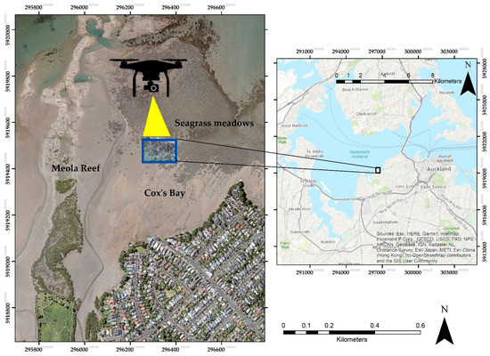
Figure 1.
Location of the study site, North Island of New Zealand. Seagrass meadows are spatially located adjacent to the Meola intertidal reef, where wild oyster reefs and mangroves dominate. Base imagery source: Land Information New Zealand (LINZ), 2019 [39].
In addition, Cox’s Bay is ~6 km from Auckland, one of New Zealand’s largest cities, and the port of Auckland and this bay have been increasingly influenced by urban expansion, pollution, forestry, and over-fishing, altering the dynamics of marine biodiversity and the ecosystem [36]. In wider Waitemata Harbour, the Research and Evaluation Unit (RIMU) of the Auckland Council has identified an increase in sediment concentration levels [12]. Increased sedimentation has been implicated as a primary reason for declining seagrass density by smothering and obstructing sunlight [38]. In addition, a water quality report from a nearby Motions Creek (a primary freshwater creek upstream of the seagrass bed) indicates an increasing concentration in extractable metal content such as copper, lead, and zinc [34].
2.2. Data Collection
The seasonal RPAS imagery was collected using a DJI Phantom 4 Pro during summer, autumn, and winter of 2019. Figure 2 displays a very high-resolution VIS (true-color) and VIS+NIR (false-color) orthomosaics of the study area created using Pix4D® mapper [40] and structure from motion (SfM) photogrammetry technique (Pix4D). The SfM photogrammetry technique estimates extrinsic and intrinsic camera parameters from overlapping imagery [41]. The high quality of the orthomosaics produced is dependent on appropriate flight planning, the flight altitude, aircraft speed, and the sensor’s field of view [25]. For data collection, two sensors were integrated on the same aircraft (1) a DJI 1/2.3″ (Complementary Metal Oxide Semiconductor) CMOS sensor with VIS (red (564–580 nm), green (535–545 nm), and blue (420–440 nm) bands) with a ground sampling distance of approximately 1.35 cm/pixel (Figure 2a) and (2) a MicaSense RedEdge-M sensor with VIS+NIR, green (475 nm), blue (560 nm), red (668 nm), RedEdge (717 nm), and near infrared (840 nm) bands and a ground sampling distance of approximately 3.47 cm/pixel from an altitude of 50 m (Figure 2b). The VIS+NIR images were radiometrically corrected using the MicaSense Calibration panel and correction values for each band.
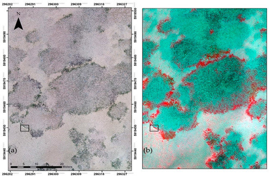
Figure 2.
(a) VIS true-color image composite and (b) VIS+NIR false-color image composite. The black square in both imageries reveals one of the ground control points from the ten used for geometric correction.
2.3. On-Site Survey and Classification Schema
All the seasonal time-series orthomosaics were orthorectified (geometric corrected) using respective Global Position System (GPS) logs of camera positions and ten ground control points (GCPs) distributed across the site. A sample of the ground control point is shown in Figure 2. These GCPs were checkerboard style printed on an A3 paper and laminated to identify the target’s center accurately, and all the GCP’s were surveyed using a high accuracy RTK-GNSS system, Septentrio®. During the image process in Pix4D, these GCPs were identified in the dense point cloud and their surveyed waypoints to enhance the positional accuracy. The orthorectification process ensures that both orthomosaics are well aligned to show the same features on the ground and attain high positional accuracy. A classification schema was created based on a US geological survey seagrass classification schema that recommends a simple system has a better chance of reliability and enhanced accuracy during the mapping results [42]. The purpose of the classification schema is to describe the morphology of the seagrass present as absent, low density, medium density, and high density in the defined spatial extent, not the shoots per square meter (biomass density) (Figure 3).
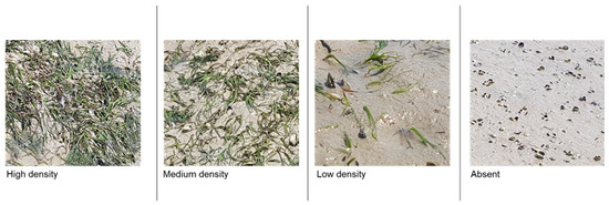
Figure 3.
The classification schema to map seagrass density and distribution across the study area. Seagrass density on the ground is referred to absent as 0%, low as 1–40%, medium as 40–70% and high density as 70–100%. Seagrass images courtesy of Kavita Prasad.
2.4. Identification of Macrofauna Benthic Activity from Their Feeding Burrows
The following species were observed in the study area during ground-truthing: Aricidea sp. (polychaetes), Boccardia syrtis (polychaetes), Heteromastus filiformis (polychaetes), Prionopsio aucklandica, Austrovenus stutchburyi (cockle), Linucula hartvigiana (clam), Macomona liliana (clam), Colurostylis lemurum, Notoacmea scapha (limpet), and Diloma subrostrate (snail). In addition, we observed and photographed many feeding burrows in the study area centered among seagrass meadows and unvegetated areas (Figure 4). We did not know which species was responsible for the feeding burrows, so we dug up a minimum of 20 burrows and mostly found Heteromastus filiformis (polychaetes) in the study area. These polychaetes were unharmed and returned safely to their habitats. In the drone aerial imagery, these feeding burrows were identifiable as dark-colored spots with low reflectance among seagrass meadows and unvegetated sediment (Figure 5). Moreover, the location of each feeding burrow in the study area was manually digitized in ArcMap (version 10.8) from the VIS and VIS+NIR time-series seasonal imagery to evaluate the trend of increase or decline.
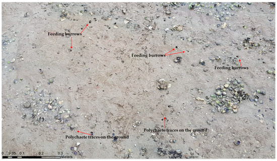
Figure 4.
A ground truthing image shows macrofauna benthic activity from feeding burrows and traces of polychaetes crawling in the sediment.
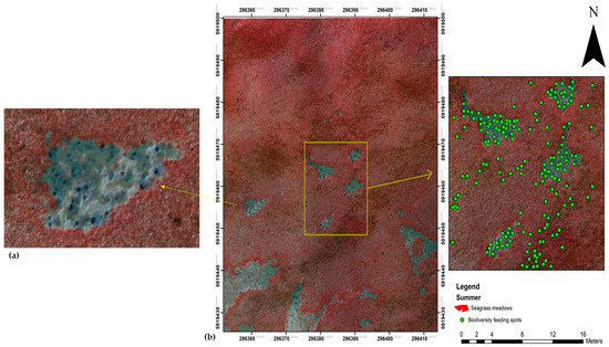
Figure 5.
(a) A zoomed-in section from the summer aerial imagery showing an example of feeding burrows. (b) Digitized feeding burrows symbolized as green dots in ArcMap.
2.5. Vegetation Indices for Supervised Classification
Vegetation indices are derivatives calculated from VIS and VIS+NIR spectral bands to identify multiple vegetation classes and densities [43]. The VIS+NIR spectral bands from the MicaSense RedEdge-M sensor were used to compute and test indices for seagrass detection. The vegetation indices evaluated were (1) normalized difference vegetation index (NDVI) [44], (2) green normalized difference vegetation index (GNDVI) [45], (3) difference vegetation index (DVI) [46], and (4) enhanced vegetation index (EVI) [47]. After evaluation, NDVI, with its normalized difference formula from reflectance and highest absorption in chlorophyll-a, makes it robust over other indices. Moreover, the VIS spectral band from the DJI sensor was used to compute (1) visible atmospherically resistant index (VARI) [48] and sum green index (SGI) [49]. For the VIS sensor, the SGI was used as this is one of the most detailed vegetation indices used to detect the seasonal change in vegetation greenness reflected across the 500 nm to 600 nm spectrum.
2.6. Support Vector Machine Classification
ArcGIS Pro v2.7 software was used for pixel-based supervised classification and accuracy assessments after assessing binary encoding, Mahalanobis distance, maximum likelihood, minimum distance, spectral angle mapper, and support vector machine classifiers [50]. For pixel-based supervised classification, both orthomosaics were classified with a support vector machine (SVM) learning classifier. This SVM classifier is less susceptible to noise and needs fewer training samples. Spectral reflectance signature files for both imageries were generated by collecting pure training samples in the Training Sample Manager Toolbox. The assigned feature class schemas were absent, low density, medium density, and high density. Using an equalized stratified random sampling strategy, fifty random samples were taken across the study area based on the features pixel spectral for every class. These samples were polygons selected around the seagrass classes containing several hundred pixels. The classification model was repeated for the time-series imagery to determine the different densities of seagrass meadows.
2.7. Accuracy Assessment
A confusion matrix was utilized as the quantitative technique for characterizing the image classification accuracy assessments [50]. The results presented the correspondence between the classification result and a reference image [51]. The results of the pixel-based supervised classification of the seasonal time-series VIS and VIS+NIR orthomosaics were assessed for accuracy using randomly generated referenced points in the high-resolution multispectral orthomosaic. For accuracy assessments, 500 random points were used, and an equalized stratified random sampling strategy was applied so that each class would have an equal number of random points. Accuracy assessments were conducted for VIS and VIS+NIR orthomosaics to produce a confusion matrices table. The confusion matrix included: an overall accuracy (defined as the percentage of all correctly classified values), a Kappa coefficient (measured the agreement between ground truth values and classification), producer’s accuracy (defined as the likelihood that an assigned class was correctly classified), and user’s accuracy (defined as the likelihood that a predicted value in a specific class is truly that class) [51].
2.8. Habitat Maps: Post Classification Detecting Seasonal Change
A technique for seasonal change detection between multi-temporal remotely sensed images uses multivariate alteration detector (MAD) transformation. This technique for pixel-based seasonal change detection is based on the theory of canonical correction analysis (CCA) to transform the data into new images with layers corresponding to each canonical variate [52]. The CCA was developed to improve image differencing techniques by making the images similar or correlated before taking their difference [52]. Images were transformed into new images with layers representing each canonical variate. The primary variate represented a linear combination containing the most correlation in the image, with successive layers containing decreasing correlations. The theory behind the MAD transformation is that by conducting this linear transformation on seasonal time-series imagery, the difference between two or more embodiments will highlight areas of seasonal change in the image. The MAD transformation analysis for seasonal change detection was executed in Geospatial Free and Open-Source Software (GFOSS) using Orfeo Toolbox, available in the QGIS environment through the Processing Toolbox. The seasonal change maps were computed based on the general growth and decline trend of Zostera muelleri in New Zealand by subtracting time-series raster imageries to show growth from summer to autumn and loss of seagrass meadows from autumn to winter.
3. Results
The VIS+NIR sensor produced a 3.5 cm/pixel spatial resolution orthomosaic, in contrast to 1.3 cm/pixel spatial resolution orthomosaic from the VIS sensor. Although both sensors had a finer spatial resolution, detecting the different densities of seagrass meadows directly from the orthomosaics was technically challenging due to spectral mixing and difference in the length of seagrass blades. Hence, the spectral indices technique was applied to solve this challenge and achieved consistent classification accuracy from VIS and VIS+NIR sensors, as the results (Table 1) attest. Moreover, for proximal low-altitude aerial surveys of seagrass meadows in the study area, winter was identified as the best season because of consistent lighting conditions and less spectral reflection from the land cover.

Table 1.
The accuracy assessment of seasonal time-series seagrass classification for VIS and VIS+NIR orthomosaic, including the user accuracy “U-acc” and producer accuracy “P-acc,” and the overall accuracy for the classified features versus referenced data (“Overall Accuracy”) and the Kappa coefficient. Kappa coefficient estimates of zero indicate a random association and increasing values towards one showing an increasingly no-random result.
3.1. VIS Classification
SVM classification produced an average overall class accuracy of 93% and an average Kappa of 0.90. The absent feature class scored an average user accuracy of 0.98 (Table 1). Low seagrass density cover achieved an average user class accuracy of 0.79. At the same time, the medium-density seagrass cover scored an average user class accuracy of 0.72. High seagrass density cover achieved an average user accuracy of 0.97. The average high-density class established that high-density seagrass coverage was easy to detect and less susceptible to spectral mixing compared to other classes.
VIS+NIR Classification
SVM classification produced an average overall class accuracy of 95% and an average Kappa of 0.93. The absent feature class scored an average user accuracy of 1 (Table 1). Low seagrass density cover achieved an average user class accuracy of 0.73. In contrast, the medium density seagrass cover scored an average user class accuracy of 0.69. Furthermore, the high seagrass density cover scored an average user class accuracy of 0.98. In addition, the high-density seagrass class coverage achieved a better classification accuracy than other classes because of their unique spectral reflection in the NIR region, increasing their ability to be distinguished effectively from other features classes, for example, in Figure 2.
3.2. Identification of Macrofauna Benthic Activity from Their Feeding Burrows
The analysis of abundance and distribution of feeding burrows from remotely sensed imagery showed a high abundance of macrofauna benthic activity during summer (Figure 5). However, as seagrass meadows started to decline towards autumn, macrofauna benthic activity simultaneously decreased. The quantified statistical results show that the transition from autumn to winter significantly affected the macrofauna benthic activity, with a significant decrease in macrofauna benthic activity feeding burrows (Figure 6). These statistical results of macrofauna benthic activity from their feeding burrows are directly related to seagrass abundance and distribution (Figure 7).
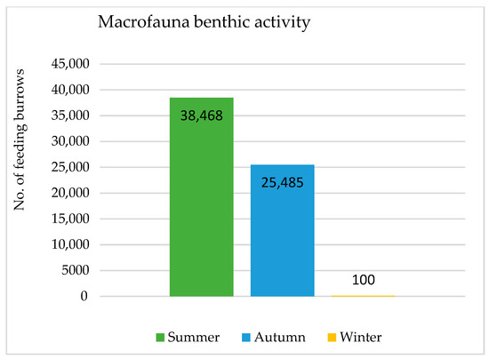
Figure 6.
Graph showing macrofauna benthic activity from their feeding burrows from the time-series seasonal imagery.
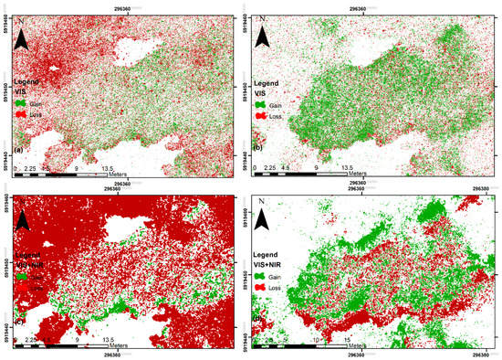
Figure 7.
Time-series density seasonal change in seagrass meadows. Using VIS orthomosaic (a) gain and loss of seagrass across summer to autumn and (b) gain and loss across autumn to winter. Using VIS+NIR orthomosaic (c) gain and loss of seagrass from summer to autumn, (d) gain and loss across autumn to winter.
3.3. Habitat Maps: Post Classification Seasonal Change Detection
The supervised classification model applied to the seasonal time-series imageries revealed distinct absent, low-density, medium-density, and high-density seagrass coverage areas across summer towards winter. Furthermore, the calculated difference between the classified maps illustrated seagrass gain and loss areas across the study area in the seasonal time series imagery, Figure 7. The quantitative seasonal change analysis revealed a trend of overall loss across summer to autumn and gain in abundance and distribution from autumn to winter, Figure 8. Although the quantitative values calculated from VIS and VIS+NIR sensors produced different results, loss and gain trends across summer to autumn and autumn to winter were consistent. This result means that an average loss across summer to autumn was 17%, and an average gain was 15% from the VIS imagery. In contrast, the VIS+NIR revealed a loss across summer to winter of 39% and an average gain of 12%.
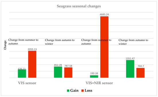
Figure 8.
Graph of time-series density seasonal change in seagrass meadows using VIS and VIS+NIR orthomosaic from summer to autumn and autumn to winter.
4. Discussion
Seagrass meadows are a crucial part of many marine ecosystems [53,54]. However, seagrass loss from anthropogenic pressure such as discharge of sediments and pollutants from local runoffs and global climate seasonal change are concerns that need to be mitigated to protect this critical resource. Hence, this study tested the performance of VIS and VIS+NIR sensors to detect fine-scale time-series seagrass seasonal change in a dynamic nearshore marine environment using spectral indices and a supervised classification technique. In addition, we aimed to answer the following ecological question: What effect does seagrass gain and loss have on the abundance and distribution of macrofauna benthic activity by quantifying an increase or decrease in macrofauna benthic activity feeding burrows from drone imagery?
The quantitative analysis of macrofauna benthic activity from the drone imagery showed a direct linkage between the seasonal variation of seagrass and the abundance and distribution of macrofauna benthic activity. The results established that macrofauna benthic activity is impacted and decreases when the abundance and distribution of seagrass meadows are low, for example, in winter. This finding is important because the loss of keystone species such as seagrass could affect the normal ecosystem functioning and ignite a broader scale degradation as the linkage between associated species is fragmented. In addition, this research has built on previous knowledge and advanced on the following: (1) achieved a consistent technique for mapping and monitoring dynamic seasonal change in seagrass density along the intertidal zone during low tide, (2) established the efficacy of a cost-effective VIS sensor and compared a VIS+NIR sensor for mapping fine-scale seagrass density seasonal change, (3) ability to quantify fine-scale density seasonal change in an open-source geoprocessing software, QGIS, and (4) achieved a repeatable technique for quantitative ecological assessments and monitoring with high spatial resolution and revisit positional accuracy.
4.1. The Performance of the Sensors and the SVM Classifier
Although the VIS imagery had a finer spatial resolution, the VIS+NIR imagery had a better spectral resolution of five spectral bands. Seagrass meadows highly reflect the NIR spectrum, which was fundamental in identifying different densities of seagrass meadows in this study. However, the VIS orthomosaic provided a better ground sampling distance than the VIS+NIR orthomosaic. Furthermore, the results from the ground truth datasets were 99% in agreement with the VIS+NIR sensor compared to 90% from the VIS sensor. Moreover, the classification accuracies are attributed to the training of the classification model, SGI vegetation index, and NDVI spectral index. In addition, the application of a machine learning classifier SVM performed better with these spectral indices and produced a high classification accuracy. Other researchers had also established that advanced machine learning classifiers like SVM are more trusted algorithms for coastal remote sensing [55,56].
Furthermore, in a related study for mapping seagrass Zostera marina with a VIS sensor, the classification accuracy was higher for dense seagrass cover [28]. Similarly, researchers using Parrot Sequoia multispectral sensor in the Coromandel Peninsula in New Zealand for seasonal change seagrass detection achieved high classification accuracy with dense seagrass than other classes [32]. Moreover, this research achieved similar results, showing higher classification accuracy with dense seagrass than other classes. The primary reason for achieving high classification accuracy results is spectral unmixing, which increases the ability of the classification model to predict high-density seagrass successfully while avoiding false positive and false negative pixel classification.
VIS+NIR Classification Analysis
The VIS+NIR sensor produced an orthomosaic of 3.5 cm/pixel spatial resolution. In addition, the positional accuracy in longitude and latitude for the georectified orthomosaics was 0.02 m. The VIS+NIR imagery achieved an overall classification accuracy of 92% in summer, 94% in autumn, and 98% in winter (Table 1). Sediment feature class and high-density feature class with the supervised classification technique scored well, achieving user’s accuracy scores ranging from 0.96 to 1. These results indicate that the SVM classification technique successfully predicted sediment and high-density training polygons while avoiding false positive and false negative pixels during classification. In contrast, low and medium density classes with the supervised classification technique scores were satisfactory, achieving user’s accuracy scores ranging from 0.66 to 0.90. These results indicate that the SVM classification technique had errors in successfully predicting medium- and low-density training polygons while excluding true-positive and true-negative pixels during classification.
Furthermore, winter was the optimum season for aerial surveys of seagrass meadows in the study area. In addition, the high density of seagrass meadows across the time-series seasonal achieved high classification accuracy. Moreover, the results achieved from this study are harmonized with other studies [13,28,30,31] that showed that low altitude proximal remote sensing with RPAS is a valuable tool for identifying seasonal change and for monitoring of intertidal seagrass meadows.
4.2. Identification of Macrofauna Benthic Activity Feeding Burrows
Researchers have established that to understand the importance of landscape patterns on seagrass meadows, it is essential to comprehend the connection between seagrass distribution dynamics and the abundance of macrofauna benthic activity [5,57]. Hence, this research also aimed to answer the question: What is the effect of seagrass gain and loss on the abundance and distribution of macrofauna benthic activity? The results from time-series imagery showed that the abundance of macrofauna benthic activity feeding burrows during summer was higher than in autumn. This abundance is associated with the high abundance and distribution of seagrass meadows during summer. This high benthic activity was more centralized among the seagrass meadows than other locations because seagrass meadows protect macrofauna species from predators and are a food source. This statement is justified by quantifying benthic activity and its association with seagrass gain and loss from the high spatial resolution orthomosaics.
During autumn, the abundance and distribution of seagrass meadows were low, mainly from black swans grazing on seagrass beds during their molting season. As a result, the macrofauna species lost protection and the benthic activity began to decline as attested by quantifying the high spatial resolution orthomosaic. Furthermore, during winter, the abundance and distribution of seagrass meadows were very low, with seagrass meadows regenerating in the study area. As a result of the abundance of macrofauna benthic activity, feeding burrows were highly impacted and reduced to a hundred as attested and quantified from the high spatial resolution drone orthomosaic.
Furthermore, researchers have used in situ datasets and satellite aerial imagery to map Zostera’s expansion of seagrass meadows associated with an abundance of macrofauna benthic activity diversity [34]. Similar conclusions were made by [14,58,59,60,61]. These studies have highlighted more diversity and abundance of macrofauna and various functional groups within Zostera beds than the neighboring unvegetated sediments in New Zealand estuaries. Other macrofauna studies (e.g., oysters, mussels, clams, and cockles) benthic activity among seagrass beds in Manukau Harbour have also supported the spatial density of seagrass at landscape scales. For example, patch isolation and fractal dimension can influence community structure [5]. These studies revealed the importance of landscape variation patterns on seagrass meadows. Hence, researchers need to comprehend seagrass dynamics and spatial distribution for monitoring and mapping seasonal change in an estuary. However, complexity in mapping and monitoring seagrass habitats arises when they are collectively impacted by anthropogenic and climate seasonal change [4,11]. Furthermore, the meadows’ reaction to these impacts may not have been anticipated, and the response may differ spatially, making detecting seasonal change challenging. Therefore, this research could be a frontier to expedite many challenges associated with mapping and monitoring seagrass meadows in dynamic marine environments.
4.3. Habitat Maps: Post Classification Seasonal Change Detection
Apart from the techniques used, high spatial information of the drone orthomosaics was a critical factor for detecting seagrass meadows in the study area. Hence, the results achieved from the classification model showed an overall loss of seagrass meadows across summer towards autumn, Figure 7a,c and overall gain, abundance, and distribution across autumn towards winter, Figure 7b,d. Moreover, both VIS and VIS+NIR achieved high classification accuracy, but the VIS+NIR sensor showed high accuracy during ground-truthing. This sensor is more dependable because of the availability of a NIR wavelength that the seagrass meadows highly reflect. However, the result from the VIS cannot be dismissed as the difference was not significant during ground-truthing, and the advantage of this sensor was a very high spatial resolution orthomosaic for fine-scale ground sampling. In addition, this study established a repeatable technique for the spatial assessment of seagrass meadows in a dynamic marine environment in the study area.
Furthermore, as established from this study, time-series seasonal change detection enables resource managers to take counteractive action to mitigate further deterioration quickly. Such subtle seasonal change identified included: (1) a shift in species density, richness, and distribution, (2) identification of wasting disease, (3) sudden decline in distribution and abundance of macrofauna benthic activity, and (4) rapid monitoring allowing resource managers to evaluate and amend policies that avoid adverse effects to an ecosystem from the loss a ketone species. Moreover, marine ecologists and executives can use repeatable high-resolution datasets to extract invaluable information on seagrass ecology and, consequently, determine ecosystem health [1]. This continuous information flow will improve understanding of seagrass dynamics, associate macrofauna benthic activity movement within the ecosystem, and, most importantly, is applicable for conservation and planning [34]. For example, early detection of fine-scale seasonal change allows and prepares resource managers to quickly take remedial actions to mitigate further loss and deterioration of habitat and adapt management practices for conservation and planning.
Moreover, identifying drivers of seasonal change is essential for marine managers to establish a connection between natural and environmental conditions [1,12]. However, method limitations for this study included aerial survey datasets restricted for a year due to COVID-19 lockdowns and were limited to a single seagrass species. Hence, future studies should monitor and quantify seagrass density fluctuations and trends for two years or more to establish a direction in seasonal density change. In addition, the following research question needs to be answered: Are seagrass abundance and distribution seasonal changes related to environmental or natural elements? For example, seagrass bed size may reduce after heavy rainfall inundated with coastal erosion sediment and simultaneously flooded with sewage waste discharge [12].
5. Conclusions
This research used VIS and VIS+NIR sensors to detect fine-scale time-series seagrass seasonal change in a dynamic nearshore marine environment using spectral indices and a supervised classification technique. The supervised classification results showed a high level of accuracy from both sensors. The VIS sensor achieved an overall accuracy of 90–98%, while the VIS+NIR sensor achieved 92–98%. Furthermore, the classification model was used to detect time-series seasonal change detection. The time-series seasonal change detection results showed an overall loss of seagrass meadows across summer towards autumn, whereas an overall gain in abundance and distribution across autumn towards winter. In addition, both sensors, VIS and VIS+NIR, show consistent results, i.e., loss across summer to autumn and gain from autumn to winter in the abundance and distribution of seagrass meadows. Moreover, the abundance and distribution of macrofauna benthic activity feeding burrows were higher during summer as they are associated with the high abundance and distribution of seagrass meadows. Using time-series RPAS imagery combined with supervised machine learning, this analysis demonstrated valuable contributions to documenting spatial ecological seasonal change in a dynamic marine environment.
Author Contributions
Conceptualization, S.C.; Data curation, S.C.; Formal analysis, S.C.; Funding acquisition, B.B.; Investigation, S.C.; Methodology, S.C.; Resources, B.B.; Software, B.B.; Supervision, B.B.; Validation, S.C., and B.B.; Visualization, S.C.; Writing—original draft, S.C.; Writing—review & editing, S.C., and B.B. All authors have read and agreed to the published version of the manuscript.
Funding
This research received no external funding.
Acknowledgments
Here we would like to take the opportunity to thank Ashray Doshi and Len Gillman from the AUT Drone lab for RPAS equipment, specialist software, and support. In addition, thanks to The School of Science at Auckland University of Technology for the PhD student research funding that made this research possible. We would also like to thank Evan Brown, AUT Senior Technician at School of Science, for his time and effort in taking us out in the boat for high-tide aerial surveys and Seechi disk measurements. Lastly, we greatly appreciate and thank Kavita Prasad for her continual support during the fieldwork and drone surveys.
Conflicts of Interest
The authors declare no conflict of interest.
References
- Anderson, T.J.; Morrison, M.; Macdiarmid, A.B.; Clark, M.R.; Archino, R.D.; Tracey, D.M.; Wadhwa, S. Review of New Zealand’s Key Biogenic Habitats; Report; The National Institute of Water and Atmospheric Research (NIWA): Auckland, New Zealand, 2019; p. 190. Available online: https://environment.govt.nz/assets/Publications/Files/NZ-biogenic-habitat-review.pdf (accessed on 15 June 2021).
- Matheson, F.; Wadhwa, S. Seagrass in Porirua Harbour: Preliminary Assessment of Restoration Potential; NIWA Report for Greater Wellington Regional Council; Unpublished Report; Greater Wellington Regional Council: Masterton, New Zealand, 2012; 35p.
- Calleja, F.; Galván, C.; Silio-Calzada, A.; Juanes, J.A.; Ondiviela, B. Long-term analysis of Zostera noltei: A retrospective approach for understanding seagrasses’ dynamics. Mar. Environ. Res. 2017, 130, 93–105. [Google Scholar] [CrossRef] [PubMed]
- Duarte, C.M.; Losada, I.; Hendriks, I.E.; Mazarrasa, I.; Marbà, N. The role of coastal plant communities for climate change mitigation and adaptation. Nat. Clim. Chang. 2013, 3, 961–968. [Google Scholar] [CrossRef] [Green Version]
- Turner, S.; Schwarz, A.M. Management and conservation of seagrass in New Zealand: An introduction. Sci. Conserv. 2006, 264, 1–90. [Google Scholar]
- Attrill, M.J.; Strong, J.A.; Rowden, A.A. Are macroinvertebrate communities influenced by seagrass structural complexity? Ecography 2000, 23, 114–121. [Google Scholar] [CrossRef]
- Grech, A.; Chartrand, K.; Erftemeijer, P.; Fonseca, M.; McKenzie, L.; Rasheed, M.; Taylor, H.; Coles, R. A comparison of threats, vulnerabilities and management approaches in global seagrass bioregions. Environ. Res. Lett. 2012, 7, 024006. [Google Scholar] [CrossRef]
- Lin, H.; Sun, T.; Zhou, Y.; Gu, R.; Zhang, X.; Yang, W. Which genes in a typical intertidal Seagrass (Zostera japonica) indicate pollution? Front. Plant Sci. 2018, 9, 1545. [Google Scholar] [CrossRef] [PubMed] [Green Version]
- Orth, R.J.; Carruthers, T.J.; Dennison, W.C.; Duarte, C.M.; Fourqurean, J.W.; Heck, K.L.; Hughes, A.R.; Kendrick, G.A.; Kenworthy, W.J.; Olyarnik, S.; et al. A Global Crisis for Seagrass Ecosystems. Bioscience 2006, 56, 987–996. [Google Scholar] [CrossRef] [Green Version]
- Morrison, M.A.; Lowe, M.L.; Grant, C.M.; Smith, P.J.; Carbines, G.; Reed, J.; Bury, S.J.; Brown, J. Seagrass Meadows as Species and Productivity Hot Burrows New Zealand Aquatic Environment and Species Report No 137, Volume 6480, Issue 137. 2014. Available online: http://fs.fish.govt.nz (accessed on 15 June 2021).
- Fourqurean, J.W.; Duarte, C.M.; Kennedy, H.; Marbà, N.; Holmer, M.; Mateo, M.A.; Apostolaki, E.T.; Kendrick, G.A.; Krause-Jensen, D.; McGlathery, K.J.; et al. Seagrass ecosystems as a globally significant carbon stock. Nat. Geosci. 2012, 5, 505–509. [Google Scholar] [CrossRef]
- Matheson, F.E.; Reed, J.; Dos Santos, V.M.; Mackay, G.; Cummings, V. Seagrass rehabilitation: Successful transplants and evaluation of methods at different spatial scales. N. Z. J. Mar. Freshw. Res. 2017, 51, 96–109. [Google Scholar] [CrossRef]
- Chand, S.; Bollard, B. Low altitude spatial assessment and monitoring of intertidal seagrass meadows beyond the visible spectrum using a remotely piloted aircraft system. Estuar. Coast. Shelf Sci. 2021, 255, 107299. [Google Scholar] [CrossRef]
- Inglis, G.J. The seagrasses of New Zealand. In World Atlas of Seagrasses; Green, E.P., Short, F.T., Eds.; University of California Press: Berkeley, CA, USA, 2003; pp. 148–157. [Google Scholar]
- Kettles, H.; Bell, R. Estuarine ecosystems. In Freshwater Conservation under a Changing Climate, Proceedings of the Workshop Hosted by the Department of Conservation, Wellington, New Zealand, 10–11 December 2013; Robertson, H., Bowie, S., White, R., Death, R., Collins, D., Eds.; Department of Conservation: Christchurch, New Zealand, 2016; pp. 24–30. [Google Scholar]
- de Lange, P.J.; Rolfe, J.R.; Barkla, J.W.; Courtney, S.P.; Champion, P.D.; Perrie, L.R.; Beadel, S.M.; Ford, K.A.; Breitwieser, I.; Schönberger, I.; et al. Conservation status of New Zealand indigenous vascular plants, 2017. New Zealand Threat Classification Series 2017, 22. 82p. Available online: https://www.doc.govt.nz/documents/science-and-technical/nztcs22entire.pdf (accessed on 15 June 2021).
- Waycott, M.; Duarte, C.M.; Carruthers, T.J.B.; Orth, R.J.; Dennison, W.C.; Olyarnik, S.; Calladine, A.; Fourqurean, J.W.; Heck, K.L., Jr.; Hughes, A.R.; et al. Accelerating loss of seagrasses across the globe threatens coastal ecosystems. Proc. Natl. Acad. Sci. USA 2009, 106, 12377–12381. [Google Scholar] [CrossRef] [PubMed] [Green Version]
- Ha, N.-T.; Manley-Harris, M.; Pham, T.-D.; Hawes, I. Detecting Multi-Decadal Changes in Seagrass Cover in Tauranga Harbour, New Zealand, Using Landsat Imagery and Boosting Ensemble Classification Techniques. ISPRS Int. J. Geo-Inf. 2021, 10, 371. [Google Scholar] [CrossRef]
- Hobley, B.; Arosio, R.; French, G.; Bremner, J.; Dolphin, T.; Mackiewicz, M. Semi-Supervised Segmentation for Coastal Monitoring Seagrass Using RPA Imagery. Remote Sens. 2021, 13, 1741. [Google Scholar] [CrossRef]
- Unsworth, R.K.F.; McKenzie, L.J.; Collier, C.J.; Cullen-Unsworth, L.C.; Duarte, C.M.; Eklöf, J.S.; Jarvis, J.C.; Jones, B.L.; Nordlund, L.M. Global challenges for seagrass conservation. AMBIO 2018, 48, 801–815. [Google Scholar] [CrossRef] [Green Version]
- Johnston, D.W. Unoccupied Aircraft Systems in Marine Science and Conservation. Annu. Rev. Mar. Sci. 2019, 11, 439–463. [Google Scholar] [CrossRef] [PubMed] [Green Version]
- Anderson, K.; Gaston, K.J. Lightweight unmanned aerial vehicles will revolutionize spatial ecology. Front. Ecol. Environ. 2013, 11, 138–146. [Google Scholar] [CrossRef] [Green Version]
- Hossain, M.; Bujang, J.; Zakaria, M.; Hashim, M. Application of Landsat images to seagrass areal cover change analysis for Lawas, Terengganu and Kelantan of Malaysia. Cont. Shelf Res. 2015, 110, 124–148. [Google Scholar] [CrossRef]
- Duffy, J.; Pratt, L.; Anderson, K.; Land, P.; Shutler, J.D. Spatial assessment of intertidal seagrass meadows using optical imaging systems and a lightweight drone. Estuar. Coast. Shelf Sci. 2018, 200, 169–180. [Google Scholar] [CrossRef]
- Joyce, K.E.; Duce, S.; Leahy, S.M.; Leon, J.; Maier, S.W. Principles and practice of acquiring drone-based image data in marine environments. Mar. Freshw. Res. 2018, 70, 952–963. [Google Scholar] [CrossRef]
- Chayhard, S.; Manthachitra, V.; Naulchawee, K.; Buranapratheprat, A. Multitemporal mapping of seagrass distribution by using integrated remote sensing data in Kung Kraben Bay (KKB), Chanthaburi Province, Thailand. Int. J. Agric. Technol. 2018, 14, 161–170. [Google Scholar]
- Konar, B.; Iken, K. The use of unmanned aerial vehicle imagery in intertidal monitoring. Deep. Sea Res. Part II 2018, 147, 79–86. [Google Scholar] [CrossRef]
- Nahirnick, N.K.; Hunter, P.; Costa, M.; Schroeder, S.; Sharma, T. Benefits and Challenges of UAS Imagery for Eelgrass (Zostera marina) Mapping in Small Estuaries of the Canadian West Coast. J. Coast. Res. 2019, 35, 673–683. [Google Scholar] [CrossRef]
- Riniatsih, I.; Ambariyanto, A.; Yudiati, E.; Redjeki, S.; Hartati, R. Monitoring the seagrass ecosystem using the unmanned aerial vehicle (UAV) in coastal water of Jepara. IOP Conf. Ser. Earth Environ. Sci. 2021, 674, 012075. [Google Scholar] [CrossRef]
- Ventura, D.; Bonifazi, A.; Gravina, M.F.; Belluscio, A.; Ardizzone, G. Mapping and Classification of Ecologically Sensitive Marine Habitats Using Unmanned Aerial Vehicle (UAV) Imagery and Object-Based Image Analysis (OBIA). Remote Sens. 2018, 10, 1331. [Google Scholar] [CrossRef] [Green Version]
- Yang, B.; Hawthorne, T.L.; Searson, H.; Duffy, E. High-Resolution UAV Mapping for Investigating Eelgrass Beds along the West Coast of North America. In Proceedings of the IGARSS 2020—2020 IEEE International Geoscience and Remote Sensing Symposium, Waikoloa, HI, USA, 26 September–2 October 2020; pp. 6317–6320. [Google Scholar] [CrossRef]
- Martin, R.; Ellis, J.; Brabyn, L.; Campbell, M. Seasonal change-mapping of estuarine intertidal seagrass (Zostera muelleri) using multispectral imagery flown by remotely piloted aircraft (RPA) at Wharekawa Harbour, New Zealand. Estuar. Coast. Shelf Sci. 2020, 246, 107046. [Google Scholar] [CrossRef]
- Rodil, I.F.; Lohrer, A.M.; Attard, K.M.; Hewitt, J.E.; Thrush, S.F.; Norkko, A. Macrofauna communities across a seascape of seagrass meadows: Environmental drivers, species patterns and conservation implications. Biodivers. Conserv. 2021, 30, 3023–3043. [Google Scholar] [CrossRef]
- Lundquist, C.J.; Jones, T.C.; Parkes, S.M.; Bulmer, R.H. Seasonal change in benthic community structure and sediment characteristics after natural recolonization of the seagrass Zostera muelleri. Sci. Rep. 2018, 8, 13250. [Google Scholar] [CrossRef] [PubMed]
- Micheli, F.; Bishop, M.J.; Peterson, C.H.; Rivera, J. Alteration of seagrass species composition and function over two decades. Ecol. Monogr. 2008, 78, 225–244. [Google Scholar] [CrossRef]
- Foley, M.M.; Shears, N.T. Te Tokaroa Meola Reef Intertidal Reef Ecological Monitoring Programme: 2001 to 2017. Auckland Council Technical Report, New Zealand, TR2019/004. 2019. Available online: https://knowledgeauckland.org.nz/media/1061/tr2019-004-tokaroa-meola-reef-intertidal-monitoring-2001-to-2017.pdf (accessed on 15 June 2021).
- Turner, S.J. Growth and productivity of intertidal Zostera capricorni in New Zealand estuaries. N. Z. J. Mar. Freshw. Res. 2007, 41, 77–90. [Google Scholar] [CrossRef]
- Saunders, M.I.; Atkinson, S.; Klein, C.J.; Weber, T.; Possingham, H.P. Increased sediment loads cause non-linear decreases in seagrass suitable habitat extent. PLoS ONE 2017, 12, e0187284. [Google Scholar] [CrossRef] [Green Version]
- LINZ Land Information New Zealand. Available online: https://www.linz.govt.nz/ (accessed on 1 November 2020).
- Pix4D. Available online: www.Pix4D.com (accessed on 30 April 2020).
- Cunliffe, A.M.; Brazier, R.E.; Anderson, K. Ultra-fine grain landscape-scale quantification of dryland vegetation structure with drone-acquired structure-from-motion photogrammetry. Remote Sens. Environ. 2016, 183, 129–143. [Google Scholar] [CrossRef] [Green Version]
- Hanlon, D. APPENDIX 1: Pohnpeian Clans. In Upon a Stone Altar: A History of the Island of Pohnpei to 1890; University of Hawai’i Press: Honolulu, HI, USA, 1988; p. 211. [Google Scholar] [CrossRef]
- Xue, J.; Su, B. Significant Remote Sensing Vegetation Indices: A Review of Developments and Applications. J. Sens. 2017, 2017, 1353691. [Google Scholar] [CrossRef] [Green Version]
- LeBourgeois, V.; Bégué, A.; Labbé, S.; Mallavan, B.; Prévot, L.; Roux, B. Can commercial digital cameras be used as multispectral sensors? A crop monitoring test. Sensors 2008, 8, 7300–7322. [Google Scholar] [CrossRef] [PubMed]
- Gitelson, A.A.; Merzlyak, M.N. Remote sensing of chlorophyll concentration in higher plant leaves. Adv. Space Res. 1998, 22, 689–692. [Google Scholar] [CrossRef]
- Tucker, C.J. Red and photographic infrared linear combinations for monitoring vegetation. Remote Sens. Environ. 1979, 8, 127–150. [Google Scholar] [CrossRef] [Green Version]
- Huete, A.; Didan, K.; Miura, T.; Rodriguez, E.P.; Gao, X.; Ferreira, L.G. Overview of the radiometric and biophysical performance of the MODIS vegetation indices. Remote Sens. Environ. 2002, 83, 195–213. [Google Scholar] [CrossRef]
- Gitelson, A.A.; Kaufman, Y.J.; Stark, R.; Rundquist, D. Novel algorithms for remote estimation of vegetation fraction. Remote Sens. Environ. 2002, 80, 76–87. [Google Scholar] [CrossRef] [Green Version]
- Lobell, D.; Asner, G. Hyperion Studies of Crop Stress in Mexico. In Proceedings of the 12th Annual JPL Airborne Earth Science Workshop, Pasadena, CA, USA, 24–28 February 2003. [Google Scholar]
- Environment System Research Institute (ESRI). Accuracy Assessment for Image Classification. 2019. Available online: https://desktop.arcgis.com/en/arcmap/latest/manage-data/raster-and-images/accuracy-assessment-for-image-classification.htm (accessed on 15 June 2021).
- Foody, G.M. Status of land cover classification accuracy assessment. Remote Sens. Environ. 2002, 80, 185–201. [Google Scholar] [CrossRef]
- Nielsen, A.A.; Conradsen, K.; Simpson, J.J. Multivariate Alteration Detection (MAD) and MAF Postprocessing in Multispectral, Bitemporal Image Data: New Approaches to Seasonal change Detection Studies. Remote Sens. Environ. 1998, 64, 1–19. [Google Scholar] [CrossRef] [Green Version]
- Lamb, J.B.; van de Water, J.A.J.M.; Bourne, D.G.; Altier, C.; Hein, M.Y.; Fiorenza, E.A.; Abu, N.; Jompa, J.; Harvell, C.D. Seagrass ecosystems reduce exposure to bacterial pathogens of humans, fishes, and invertebrates. Science 2017, 355, 731–733. [Google Scholar] [CrossRef]
- Wernberg, T.; Bennett, S.; Babcock, R.C.; de Bettignies, T.; Cure, K.; Depczynski, M.; Dufois, F.; Fromont, J.; Fulton, C.J.; Hovey, R.K.; et al. Climate-driven regime shift of a temperate marine ecosystem. Science 2016, 353, 169–172. [Google Scholar] [CrossRef] [PubMed] [Green Version]
- Mountrakis, G.; Im, J.; Ogole, C. Support vector machines in remote sensing: A review. ISPRS J. Photogramm. Remote Sens. 2011, 66, 247–259. [Google Scholar] [CrossRef]
- Traganos, D.; Reinartz, P. Interannual seasonal change detection of mediterranean seagrasses using RapidEye image time series. Front. Plant Sci. 2018, 9, 96. [Google Scholar] [CrossRef] [PubMed] [Green Version]
- Hughes, A.R.; Williams, S.L.; Duarte, C.M.; Heck, K.L.; Waycott, M. Associations of concern: Declining seagrasses and threatened dependent species. Front. Ecol. Environ. 2009, 7, 242–246. [Google Scholar] [CrossRef] [Green Version]
- Alderson, S.L. The Analysis of Ecological Experiments in Which Overdispersion Is Present. Unpublished. Master’s Thesis, University of Auckland, Auckland, New Zealand, 1997. [Google Scholar]
- Bell, S.; Hicks, G. Marine landscapes and faunal recruitment: A field test with seagrasses and copepods. Mar. Ecol. Prog. Ser. 1991, 73, 61–68. [Google Scholar] [CrossRef]
- Berkenbusch, K.; Rowden, A.; Probert, P.K. Temporal and spatial variation in macrofauna community composition imposed by ghost shrimp Callianassa filholi bioturbation. Mar. Ecol. Prog. Ser. 2000, 192, 249–257. [Google Scholar] [CrossRef]
- Van Houte-Howes, K.S.S.; Turner, S.J.; Pilditch, C.A. Spatial differences in macroinvertebrate communities on intertidal sand flats: A comparison between seagrass habitats and unvegetated sediment in three estuaries on the Coromandel Peninsula, New Zealand. Estuaries 2004, 27, 945–957. [Google Scholar] [CrossRef]
Publisher’s Note: MDPI stays neutral with regard to jurisdictional claims in published maps and institutional affiliations. |
© 2021 by the authors. Licensee MDPI, Basel, Switzerland. This article is an open access article distributed under the terms and conditions of the Creative Commons Attribution (CC BY) license (https://creativecommons.org/licenses/by/4.0/).