Analysis of Activity in an Open-Pit Mine by Using InSAR Coherence-Based Normalized Difference Activity Index
Abstract
1. Introduction
2. Materials and Methods
2.1. Study Area
2.2. Data
2.2.1. SRTM and TanDEM-X DEM
2.2.2. Sentinel-1 SAR
2.3. Methods
2.3.1. Subtraction of DEMs
2.3.2. InSAR Coherence
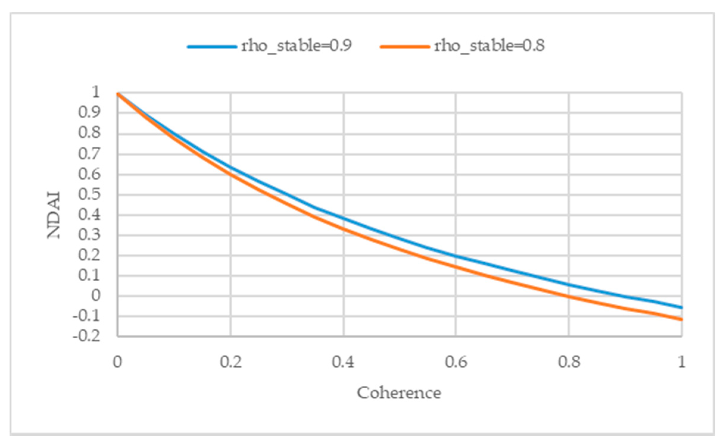
2.3.3. Normalized Difference Activity Index (NDAI)
2.3.4. Change Detection by RGB Composite of NDAIs
3. Results
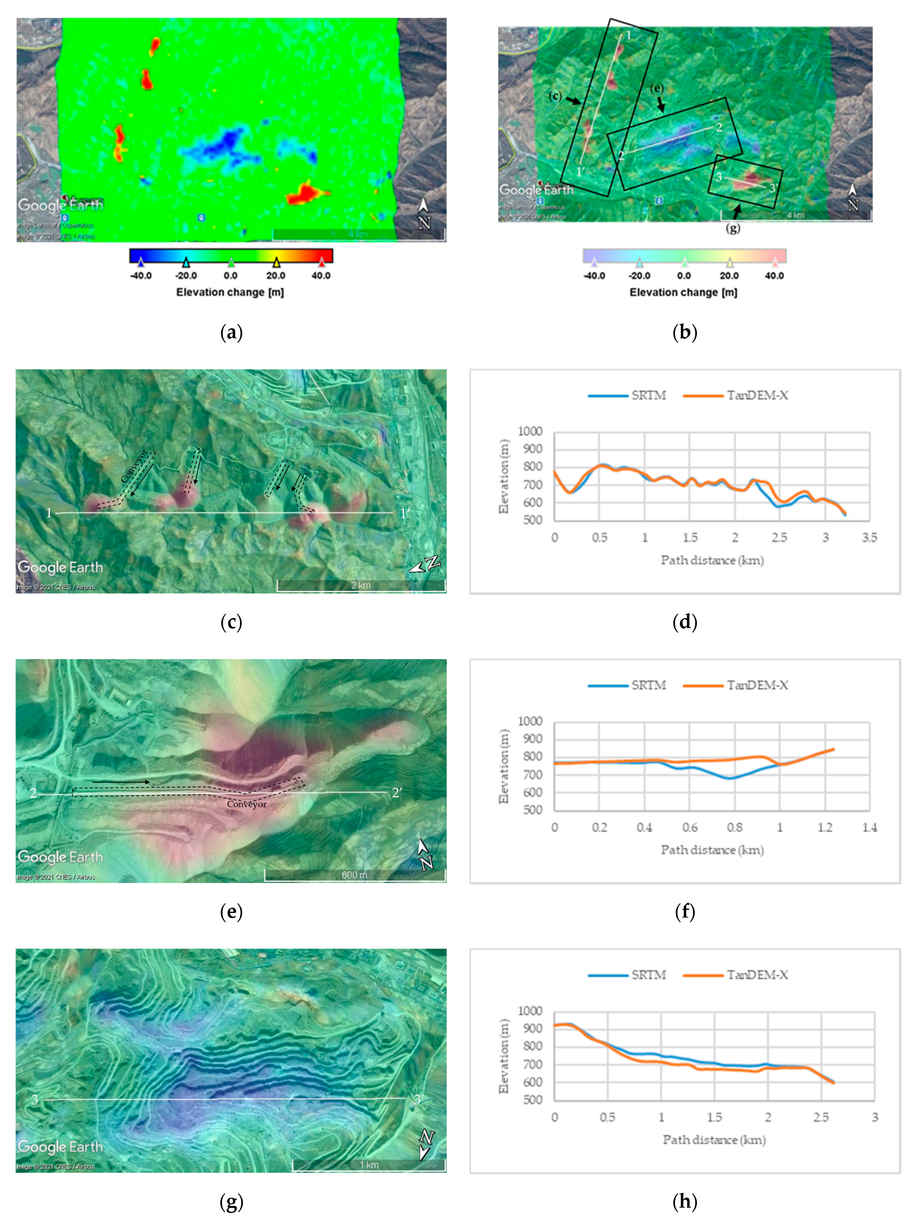
3.1. InSAR DEM Change (2000–2015)
3.2. Averaged NDAI Map (2015–2020)
3.3. RGB Composite of Annually Averaged NDAI Maps (R: 2019, G: 2018, and B: 2017)
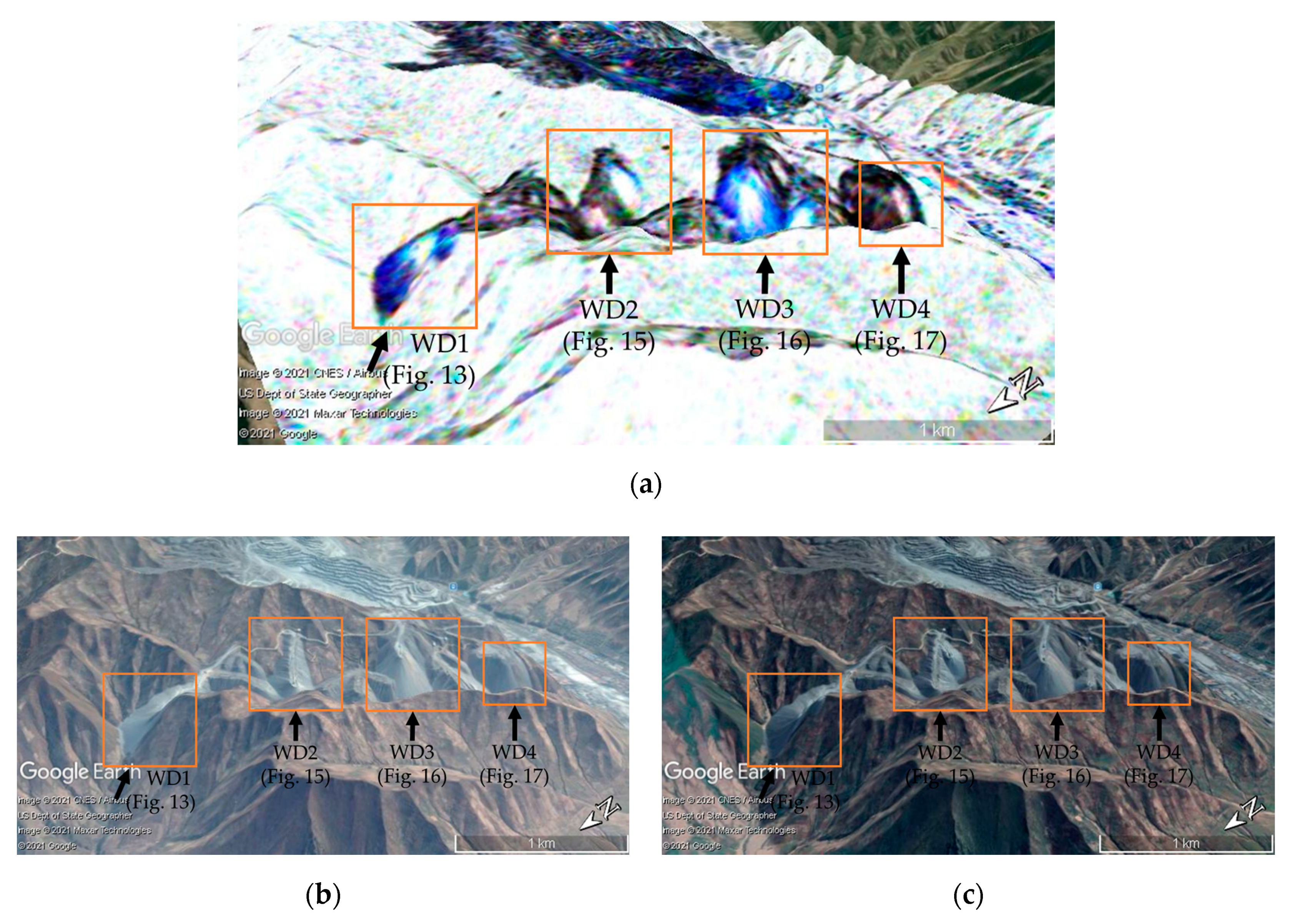
3.3.1. West Dumping Area
3.3.2. East Dumping Area
3.3.3. Excavation Site
4. Discussion
5. Conclusions
Author Contributions
Funding
Institutional Review Board Statement
Informed Consent Statement
Data Availability Statement
Conflicts of Interest
References
- Yang, H.; Kang, S.; Seonwoo, C.; Jang, M.; Jeong, S.; Cho, S. Surface Mining Engineering; CIR: Seoul, Korea, 2016; pp. 5–292. [Google Scholar]
- Kobayashi, H.; Watando, H.; Kakimoto, M. A global extent site-level analysis of land cover and protected area overlap with mining activities as an indicator of biodiversity pressure. J. Clean. Prod. 2014, 84, 459–468. [Google Scholar] [CrossRef]
- Murguía, D.I.; Bringezu, S.; Schaldach, R. Global direct pressures on biodiversity by large-scale metal mining: Spatial distribution and implications for conservation. J. Environ. Manag. 2016, 180, 409–420. [Google Scholar] [CrossRef] [PubMed]
- Moreno-de Las Heras, M.; Merino-Martín, L.; Nicolau, J.M. Effect of vegetation cover on the hydrology of reclaimed mining soils under Mediterranean-Continental climate. Catena 2009, 77, 39–47. [Google Scholar] [CrossRef]
- Chen, W.T.; Li, X.J.; Wang, L.Z. Fine Land Cover Classification in an Open Pit Mining Area Using Optimized Support Vector Machine and WorldView-3 Imagery. Remote Sens. 2020, 12, 82. [Google Scholar] [CrossRef]
- Beighley, R.E.; Moglen, G.E. Trend assessment in rainfall-runoff behavior in urbanizing watersheds. J. Hydrol. Eng. 2002, 7, 27–34. [Google Scholar] [CrossRef]
- Simmons, J.A.; Currie, W.S.; Eshleman, K.N.; Kuers, K.; Monteleone, S.; Negley, T.L.; Pohland, B.R.; Thomas, C.L. Forest to reclaimed mine land use change leads to altered ecosystem structure and function. Ecol. Appl. 2008, 18, 104–118. [Google Scholar] [CrossRef]
- Townsend, P.A.; Helmers, D.P.; Kingdon, C.C.; McNeil, B.E.; de Beurs, K.M.; Eshleman, K.N. Changes in the extent of surface mining and reclamation in the Central Appalachians detected using a 1976–2006 Landsat time series. Remote Sens. Environ. 2009, 113, 62–72. [Google Scholar] [CrossRef]
- LaJeunesse Connette, K.J.; Connette, G.; Bernd, A.; Phyo, P.; Aung, K.H.; Tun, Y.L.; Thein, Z.M.; Horning, N.; Leimgruber, P.; Songer, M. Assessment of mining extent and expansion in Myanmar based on freely-available satellite imagery. Remote Sens. 2016, 8, 912. [Google Scholar] [CrossRef]
- Julzarika, A. Mining land identification in Wetar Island using remote sensing data. J. Degrad. Min. Lands Manag. 2018, 6, 1513–1518. [Google Scholar] [CrossRef]
- Lobo, F.D.L.; Souza-Filho, P.W.M.; Novo, E.M.L.d.M.; Carlos, F.M.; Barbosa, C.C.F. Mapping Mining Areas in the Brazilian Amazon Using MSI/Sentinel-2 Imagery (2017). Remote Sens. 2018, 10, 1178. [Google Scholar] [CrossRef]
- Ross, M.R.V.; McGlynn, B.L.; Bernhardt, E.S. Deep impact: Effects of mountaintop mining on surface topography, bedrock structure, and downstream waters. Environ. Sci. Technol. 2016, 50, 2064–2074. [Google Scholar] [CrossRef] [PubMed]
- Lee, H. Application of KOMPSAT-5 SAR Interferometry by using SNAP software. Korean J. Remote Sens. 2017, 33, 1215–1221. [Google Scholar]
- Farr, T.G.; Rosen, P.A.; Caro, E.; Crippen, R.; Duren, R.; Hensley, S.; Kobrick, M.; Paller, M.; Rodriguez, E.; Roth, L.; et al. The shuttle radar topography mission. Rev. Geophys. 2007, 45, RG2004. [Google Scholar] [CrossRef]
- Wu, Q.; Song, C.; Liu, K.; Ke, L. Integration of TanDEM-X and SRTM DEMs and Spectral Imagery to Improve the Large-Scale Detection of Opencast Mining Areas. Remote Sens. 2020, 12, 1451. [Google Scholar] [CrossRef]
- Wang, S.; Lu, X.; Chen, Z.; Zhang, G.; Ma, T.; Jia, P.; Li, B. Evaluating the feasibility of illegal open-pit mining identification using insar coherence. Remote Sens. 2020, 12, 367. [Google Scholar] [CrossRef]
- Cenni, N.; Fiaschi, S.; Fabris, M. Monitoring of Land Subsidence in the Po River Delta (Northern Italy) Using Geodetic Networks. Remote Sens. 2021, 13, 1488. [Google Scholar] [CrossRef]
- Iasio, C.; Novali, F.; Corsini, A.; Mulas, M.; Branzanti, M.; Benedetti, E.; Giannico, C.; Tamburini, A.; Mair, V. COSMO SkyMed high frequency—High resolution monitoring of an alpine slow landslide, corvara in Badia, Northern Italy. In Proceedings of the IEEE International Geoscience and Remote Sensing Symposium (IGARSS), Munich, Germany, 22–27 July 2012; pp. 7577–7580. [Google Scholar]
- Tarighat, F.; Foroughnia, F.; Perissin, D. Monitoring of Power Towers’ Movement Using Persistent Scatterer SAR Interferometry in South West of Tehran. Remote Sens. 2021, 13, 407. [Google Scholar] [CrossRef]
- Matikainen, L.; Lehtomäki, M.; Ahokas, E.; Hyyppä, J.; Karjalainen, M.; Jaakkola, A.; Kukko, A.; Heinonen, T. Remote sensing methods for power line corridor surveys. ISPRS J. Photogramm. Remote Sens. 2016, 119, 10–31. [Google Scholar] [CrossRef]
- Cando Jácome, M.; Martinez-Graña, A.M.; Valdés, V. Detection of Terrain Deformations Using InSAR Techniques in Relation to Results on Terrain Subsidence (Ciudad de Zaruma, Ecuador). Remote Sens. 2020, 12, 1598. [Google Scholar] [CrossRef]
- Lee, H. Investigation of SAR Systems, technologies and application fields by a statistical analysis of SAR-related journal papers. Korean J. Remote Sens. 2006, 22, 153–174. [Google Scholar]
- Khalil, R.Z.; Saad-ul-Haque. InSAR coherence-based land cover classification of Okara, Pakistan. Egypt. J. Remote Sens. Space Sci. 2018, 21, S23–S28. [Google Scholar] [CrossRef]
- Korean Statistical Information Service. Available online: https://kosis.kr/index/index.do (accessed on 10 February 2021).
- Choi, K. The Mining Industry of North Korea. Korean J. Defense Anal. 2011, 23, 211–230. [Google Scholar]
- Bae, S.; Yu, J.; Koh, S.M.; Heo, C.H. 3D Modeling Approaches in Estimation of Resource and Production of Musan Iron Mine, North Korea. Econ. Environ. Geol. 2015, 48, 391–400. [Google Scholar] [CrossRef]
- Koh, S.M.; Lee, G.J.; Yoon, E. Status of Mineral Resources and Mining Development in North Korea. Econ. Environ. Geol. 2013, 46, 291–300. [Google Scholar] [CrossRef][Green Version]
- Kim, N.; Koh, S.M.; Lee, B.H. Geological Comparison Between Musan Iron Deposit in North Korea and Iron Deposits in Anshan-Benxi Area in China. J. Miner. Soc. Korea 2018, 31, 215–225. [Google Scholar] [CrossRef]
- Yoon, S.; Jang, H.; Yun, S.T.; Kim, D.M. Investigating the Status of Mine Hazards in North Korea Using Satellite Pictures. J. Korean Soc. Miner. Energy Resour. Eng. 2018, 55, 564–575. [Google Scholar] [CrossRef]
- Oh, M.; Yang, A.; Koo, Y.H.; Park, H.D. Assessment and comparison of landslide susceptibility at open-pit mines in North Korea using GIS. IOP Conf. Ser. Earth Environ. Sci. 2020, 509, 012041. [Google Scholar]
- Oh, M.; Son, J.; Park, H.D. Photovoltaic Energy Assessment near the Musan Iron Mine, North Korea, to Supply Energy. In Proceedings of the 2020 Annual Spring Meeting of the Korean Society for New & Renewable Energy, Seoul, Korea, 24–25 August 2020. [Google Scholar]
- Kim, S.M.; Suh, J.; Oh, M.; Yang, A.; Song, J.; Park, H.D. GIS-based Network Analysis of North Korea’s Transportation Infrastructure for the Trade of Mineral Resources in North Korea. J. Korean Soc. Miner. Energy Resour. Eng. 2020, 57, 159–167. [Google Scholar] [CrossRef]
- Park, J.; Joung, E. Study on North Koreas iron ore trade toward China: Focusing on the Development Situation of Musan mine. J. Northeast Asian Stud. 2017, 85, 73–98. [Google Scholar] [CrossRef]
- Kim, K.H. Reserves 5.2 billion ton(Fe 24%) of World-class open-pit mine: Clough Engineering Ltd. and Mitsui Mineral Development Engineering Co. Ltd. make a report together <First report about the present condition and investment opportunity of Musan Iron mine>. Minjog21 2002, 10, 108–113. [Google Scholar]
- Yoon, E. Status of Future of the North Korean Minerals Sector. Korean J. Defense Anal. 2011, 23, 191–210. [Google Scholar]
- Chung, J. The Mineral Industry of North Korea. Miner. Yearb. 2016, 3, 14.1–14.5. [Google Scholar]
- Nam, S.Y. Development of iron ore from North Korea and Inter-Korean Cooperation. Korean J. Unification Aff. 2014, 26, 75–113. [Google Scholar]
- Krieger, G.; Moreira, A.; Fiedler, H.; Hajnsek, I.; Werner, M.; Younis, M.; Zink, M. TanDEM-X: A satellite formation for high-resolution SAR interferometry. IEEE Trans. Geosci. Remote Sens. 2007, 45, 3317–3341. [Google Scholar] [CrossRef]
- Krieger, G.; Zink, M.; Bachmann, M.; Bräutigam, B.; Schulze, D.; Martone, M.; Rizzoli, P.; Steinbrecher, U.; Walter Antony, J.; de Zan, F.; et al. TanDEM-X: A radar interferometer with two formation-flying satellites. Acta Astronaut. 2013, 89, 83–98. [Google Scholar] [CrossRef]
- Zink, M.; Bachmann, M.; Bräutigam, B.; Fritz, T.; Hajnsek, I.; Krieger, G.; Moreira, A.; Wessel, B. TanDEM-X: The New Global DEM Takes Shape. IEEE GRSM 2014, 2, 8–23. [Google Scholar] [CrossRef]
- Rizzoli, P.; Martone, M.; Gonzalez, C.; Wecklich, C.; Tridon, D.B.; Bräutigam, B.; Bachmann, M.; Schulze, D.; Fritz, T.; Huber, M.; et al. Generation and performance assessment of the global TanDEM-X digital elevation model. ISPRS J. Photogramm. Remote Sens. 2017, 132, 119–139. [Google Scholar] [CrossRef]
- Geudtner, D.; Torres, R.; Snoeij, P.; Davidson, M.; Rommen, B. Sentinel-1 system capabilities and applications. In Proceedings of the 2014 IEEE International Geoscience and Remote Sensing Symposium (IGARSS), Quebec City, QC, Canada, 13–18 July 2014; pp. 1457–1460. [Google Scholar]
- Torres, R.; Snoeij, P.; Geudtner, D.; Bibby, D.; Davidson, M.; Attema, E.; Potin, P.; Rommen, B.; Floury, N.; Brown, M.; et al. GMES Sentinel-1 mission. Remote Sens. Environ. 2012, 120, 9–24. [Google Scholar] [CrossRef]
- Copernicus Open Access Hub. Available online: https://scihub.copernicus.eu/ (accessed on 15 March 2021).
- Alaska Satellite Facility (ASF). Available online: https://www.asf.alaska.edu/ (accessed on 15 March 2021).
- SNAP. Available online: https://step.esa.int/main/toolboxes/snap/ (accessed on 15 March 2021).
- Zebker, H.A.; Villasenor, J. Decorrelation in interferometric radar echoes. IEEE Trans. Geosci. Remote Sens. 1992, 30, 950–959. [Google Scholar] [CrossRef]
- Hoen, E.W.; Zebker, H.A. Penetration depths inferred from interferometric volume decorrelation observed over the Greenland Ice Sheet. IEEE Trans. Geosci. Remote Sens. 2000, 38, 2571–2583. [Google Scholar]
- Hanssen, R.F. Radar Interferometry: Data Interpretation and Error Analysis; Springer Science & Business Media: Dordrecht, The Netherlands, 2001; Volume 2. [Google Scholar]
- Ferretti, A.; Monti-Guarnieri, A.; Prati, C.; Rocca, F.; Massonet, D. InSAR Principles: Guideline for SAR Interferometry Processing and Interpretation; ESA Publication: Noordwijk, The Netherlands, 2007. [Google Scholar]




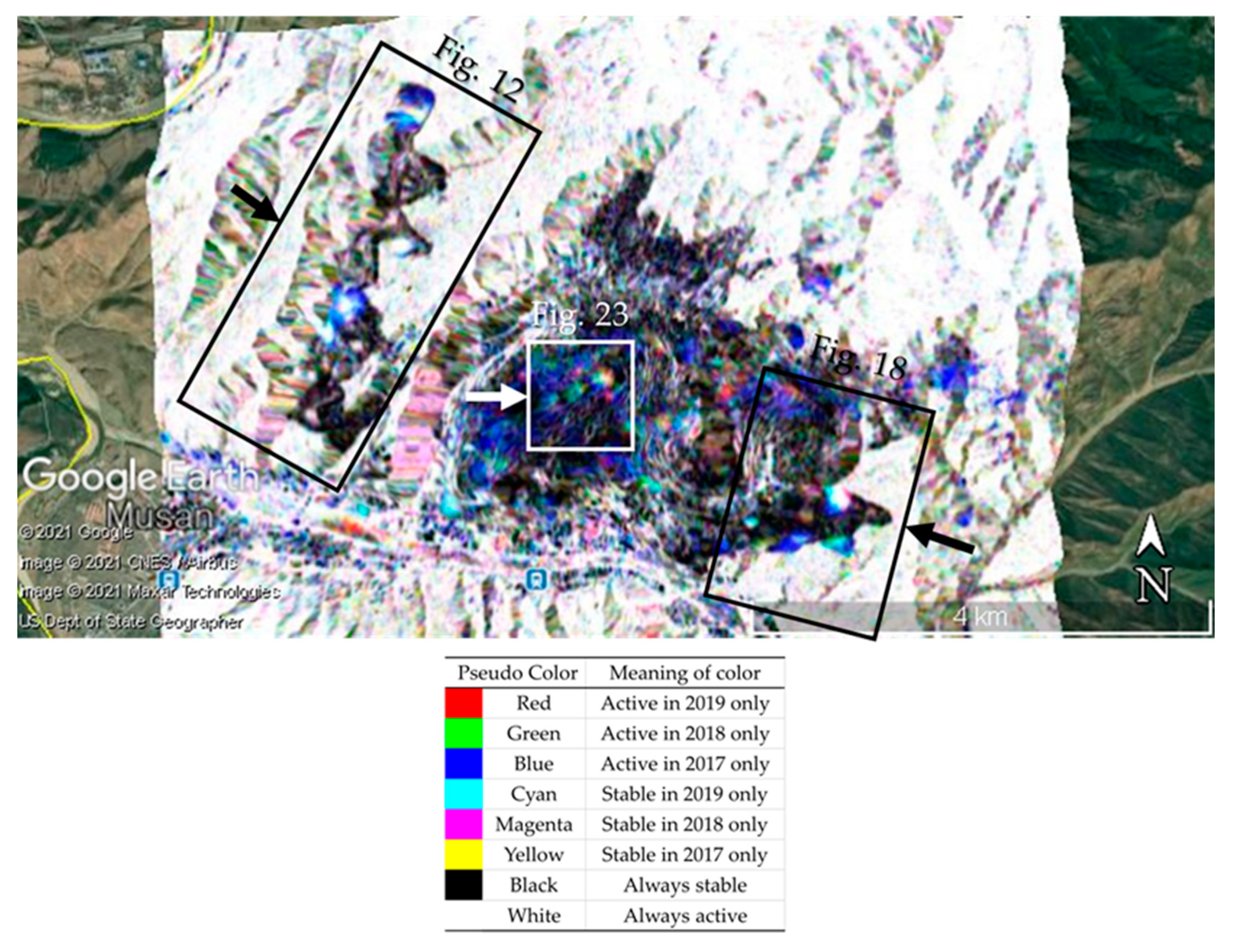

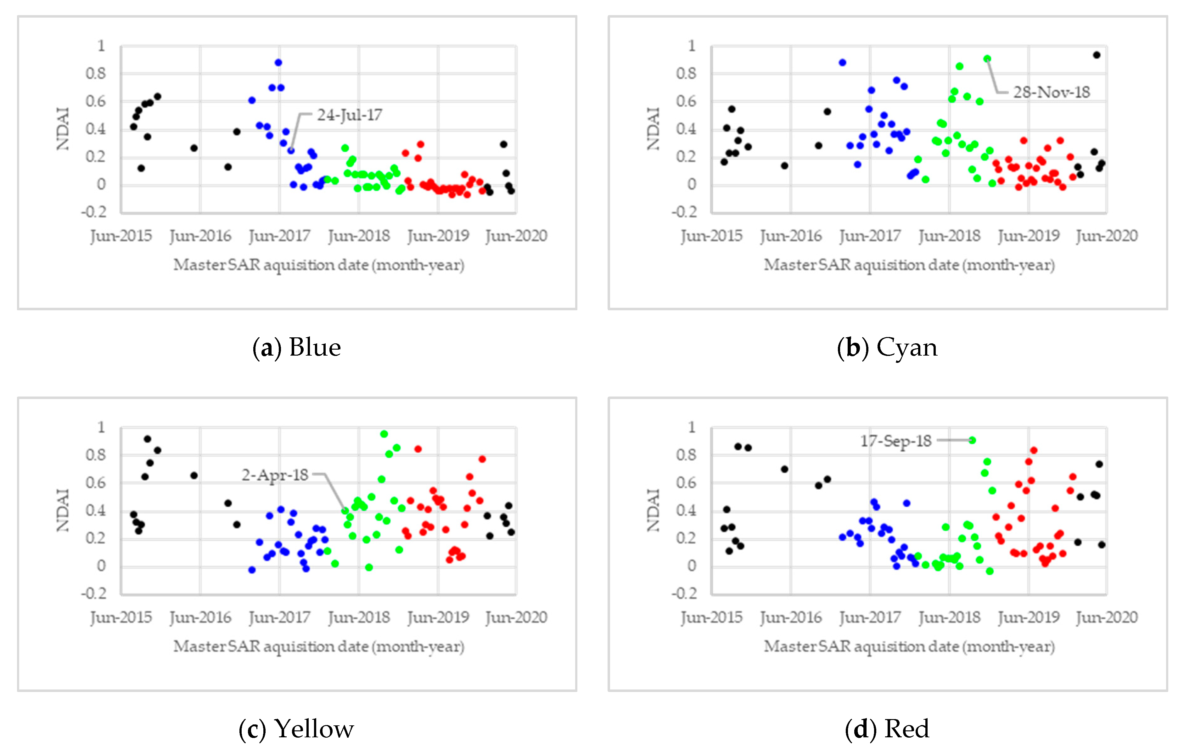


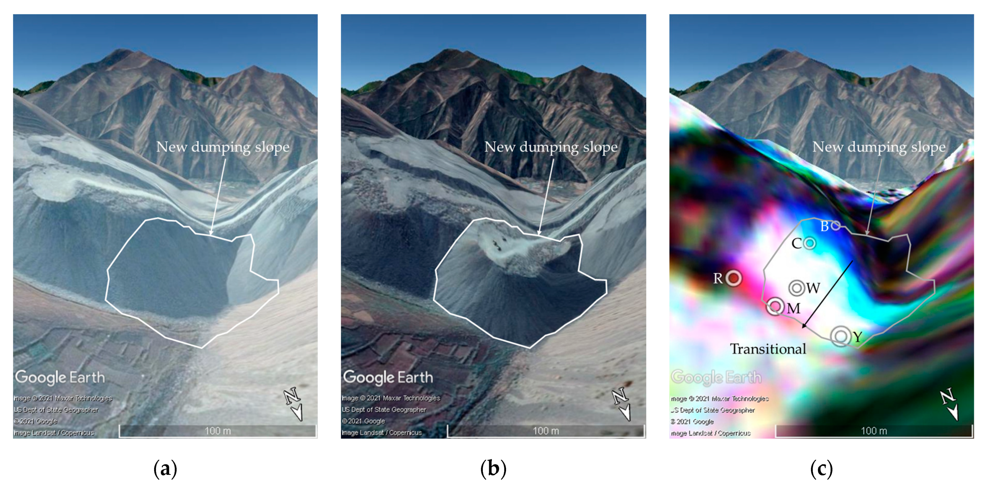


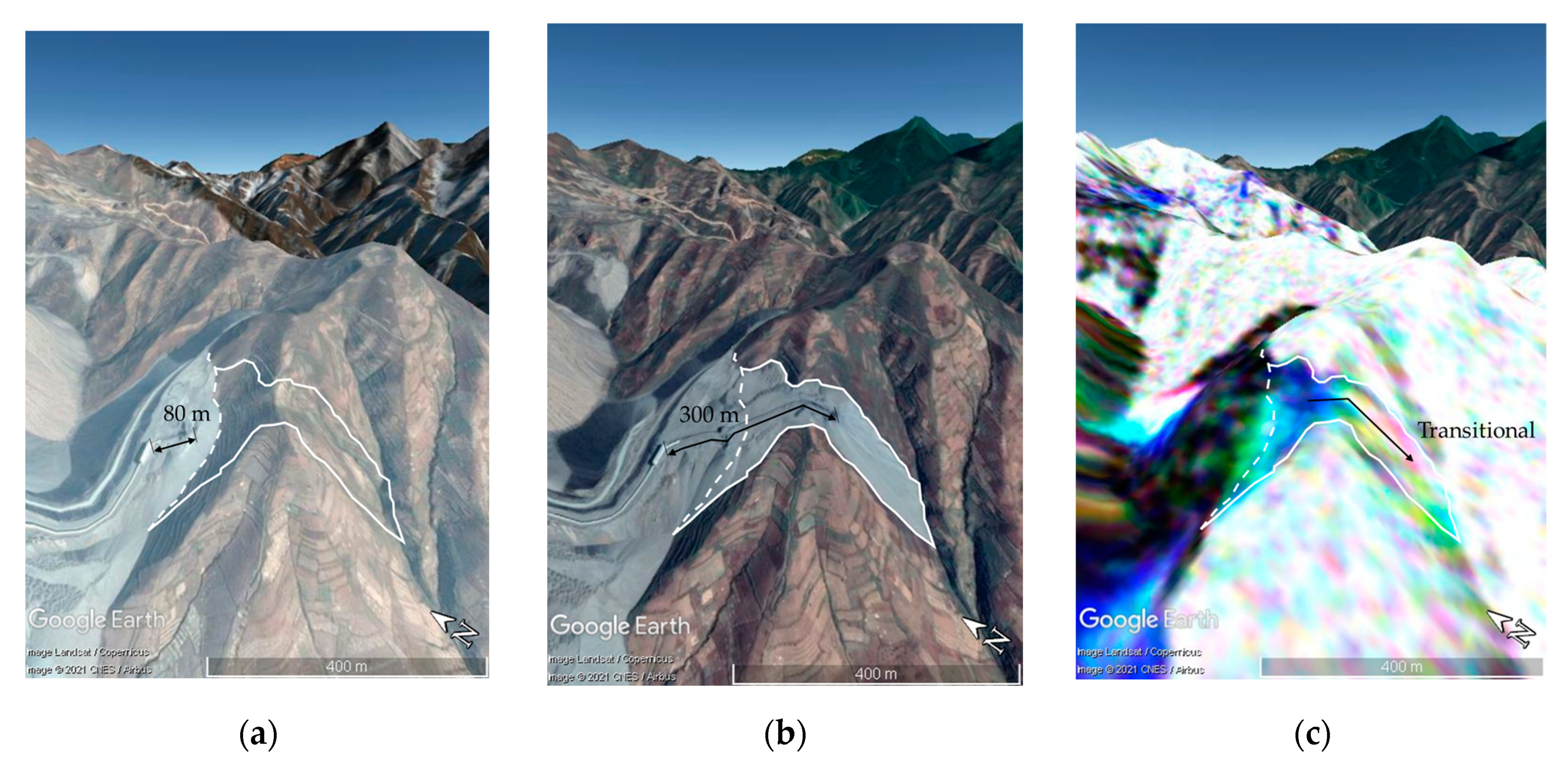
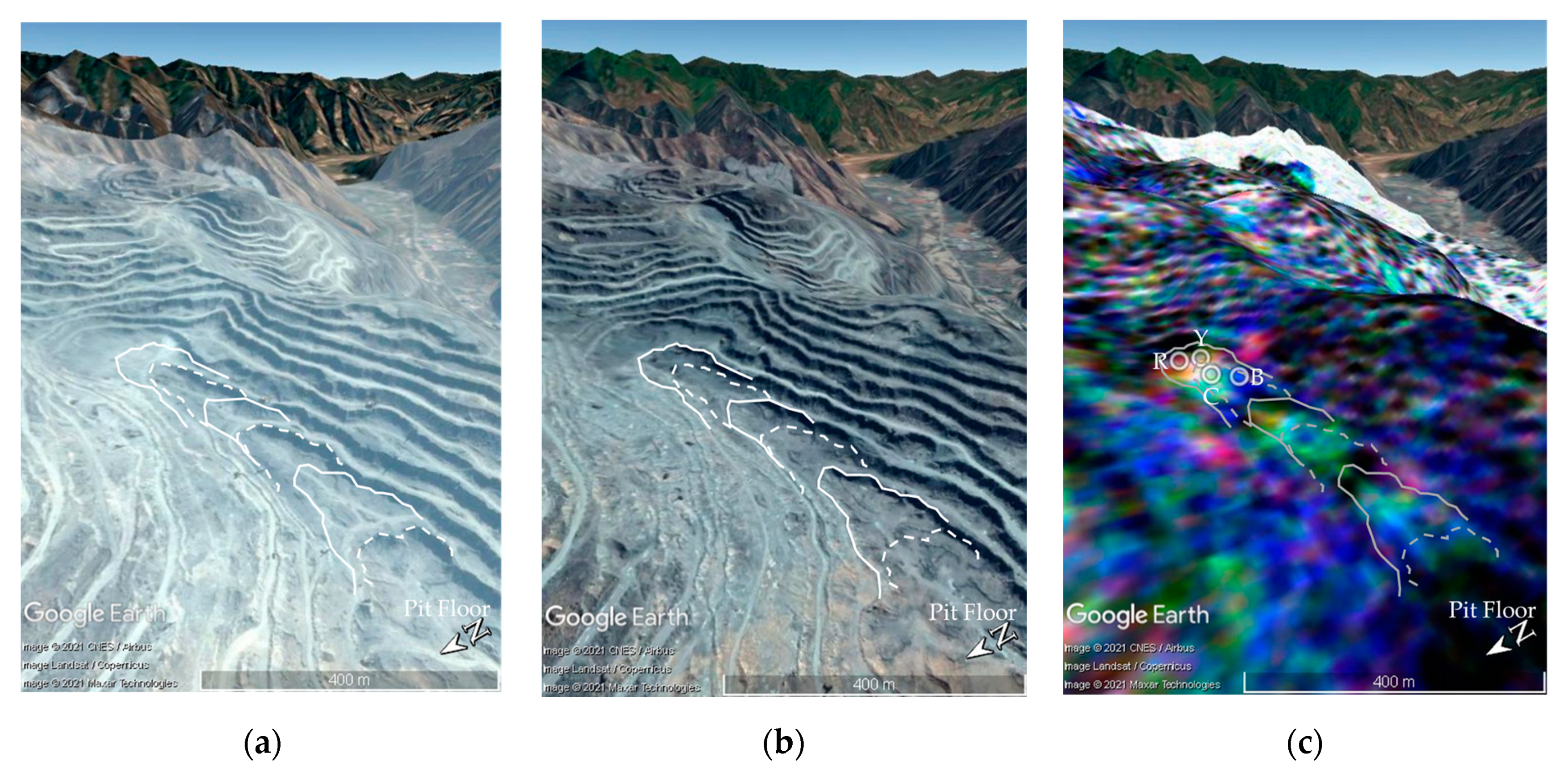

| Activity | Pseudo-Color | Meaning of Color | ||
|---|---|---|---|---|
| B: 2017 | G: 2018 | R: 2019 | ||
| Low | Low | High | Red | Active in 2019 only |
| Low | High | Low | Green | Active in 2018 only |
| High | Low | Low | Blue | Active in 2019 only |
| High | High | Low | Cyan | Stable in 2019 only |
| High | Low | High | Magenta | Stable in 2018 only |
| Low | High | High | Yellow | Stable in 2017 only |
| Low | Low | Low | Black | Always stable |
| High | High | High | White | Always active |
Publisher’s Note: MDPI stays neutral with regard to jurisdictional claims in published maps and institutional affiliations. |
© 2021 by the authors. Licensee MDPI, Basel, Switzerland. This article is an open access article distributed under the terms and conditions of the Creative Commons Attribution (CC BY) license (https://creativecommons.org/licenses/by/4.0/).
Share and Cite
Moon, J.; Lee, H. Analysis of Activity in an Open-Pit Mine by Using InSAR Coherence-Based Normalized Difference Activity Index. Remote Sens. 2021, 13, 1861. https://doi.org/10.3390/rs13091861
Moon J, Lee H. Analysis of Activity in an Open-Pit Mine by Using InSAR Coherence-Based Normalized Difference Activity Index. Remote Sensing. 2021; 13(9):1861. https://doi.org/10.3390/rs13091861
Chicago/Turabian StyleMoon, Jihyun, and Hoonyol Lee. 2021. "Analysis of Activity in an Open-Pit Mine by Using InSAR Coherence-Based Normalized Difference Activity Index" Remote Sensing 13, no. 9: 1861. https://doi.org/10.3390/rs13091861
APA StyleMoon, J., & Lee, H. (2021). Analysis of Activity in an Open-Pit Mine by Using InSAR Coherence-Based Normalized Difference Activity Index. Remote Sensing, 13(9), 1861. https://doi.org/10.3390/rs13091861


