
Sentinel-2 Exposed Soil Composite for Soil Organic Carbon Prediction


Abstract
1. Introduction
2. Materials and Methods
2.1. Study Site and Sample Collection
2.2. Remote Sensing Data
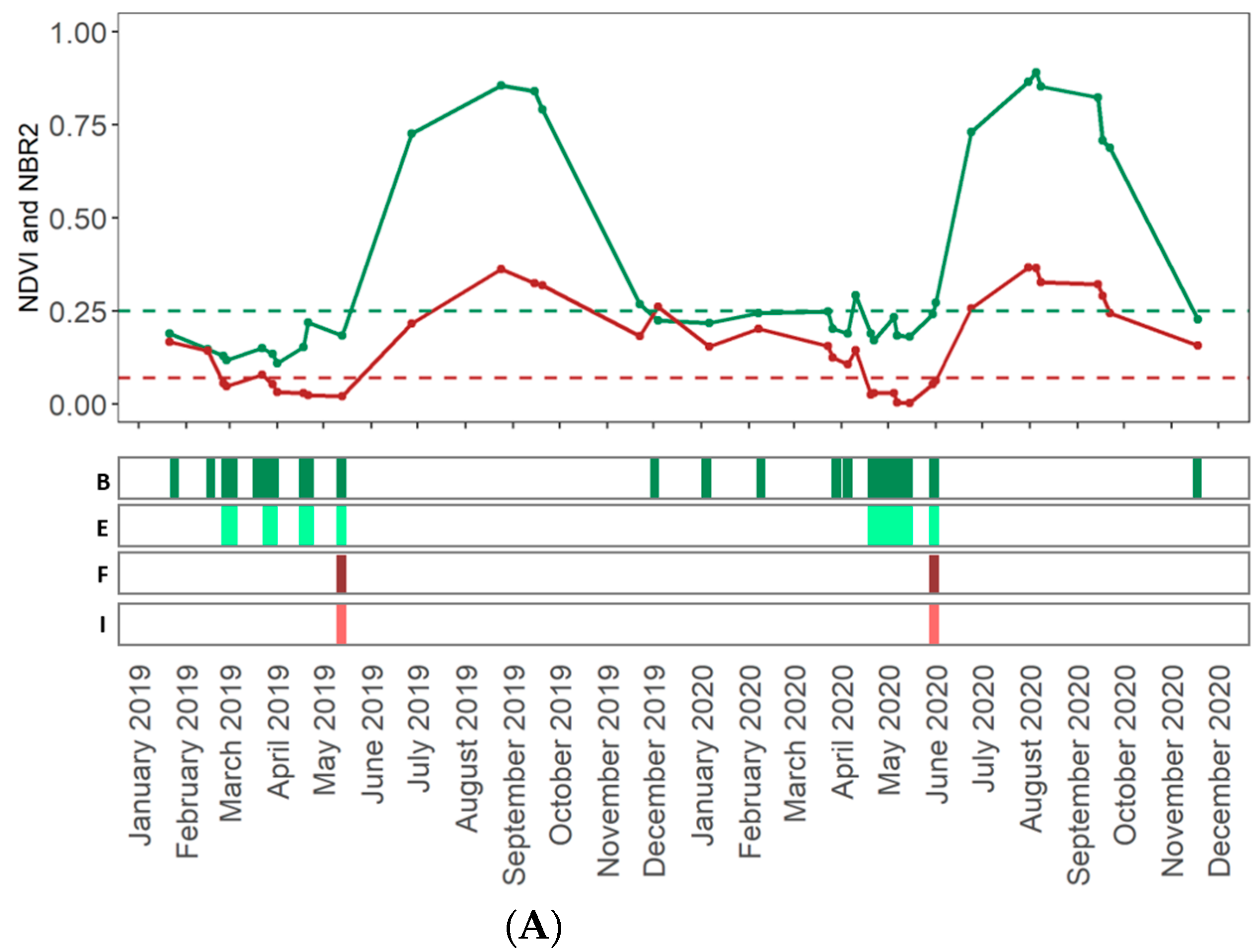
2.3. Spectral Indices
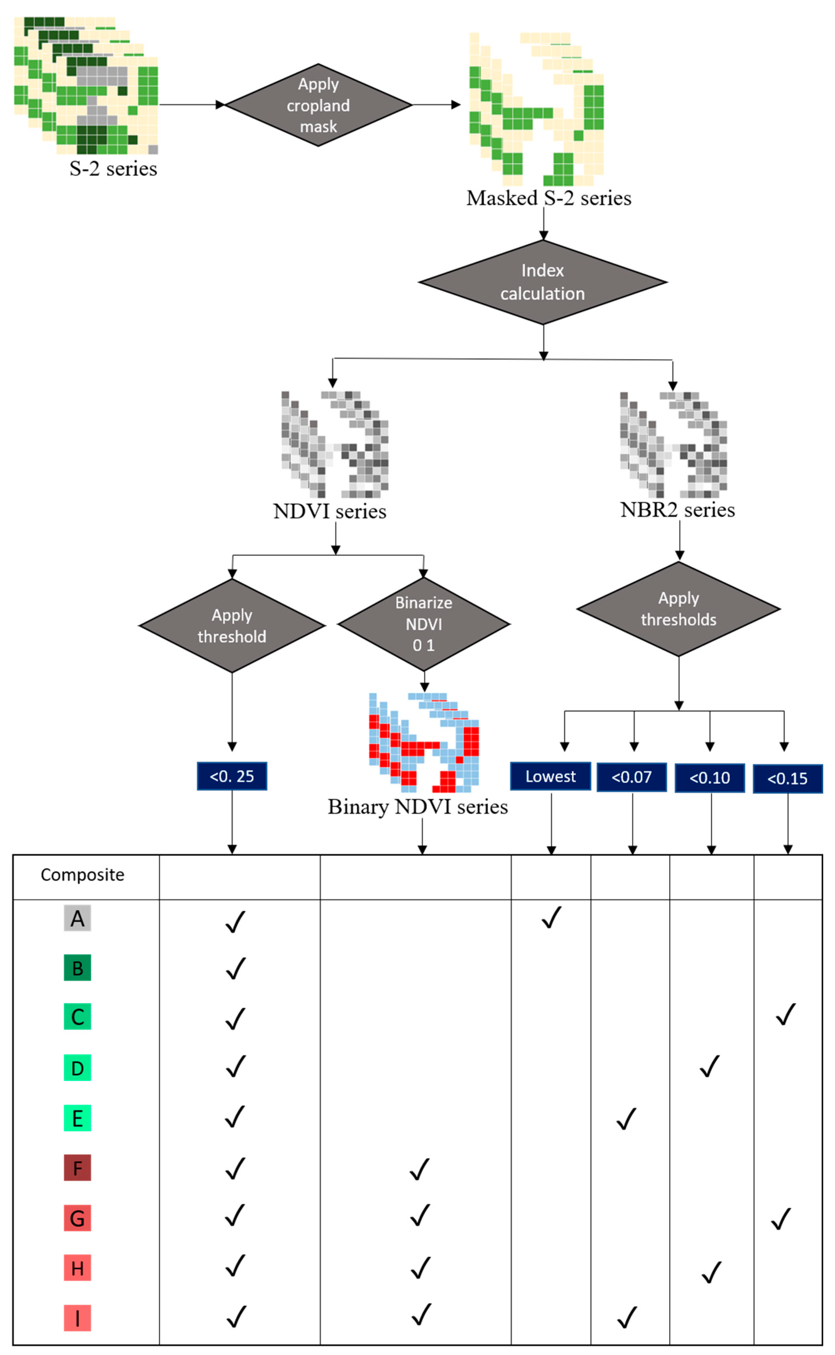
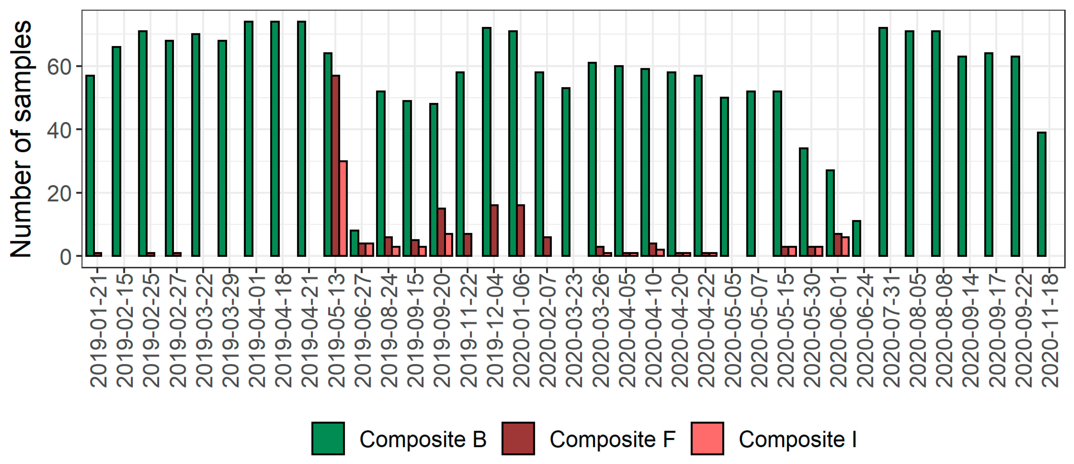
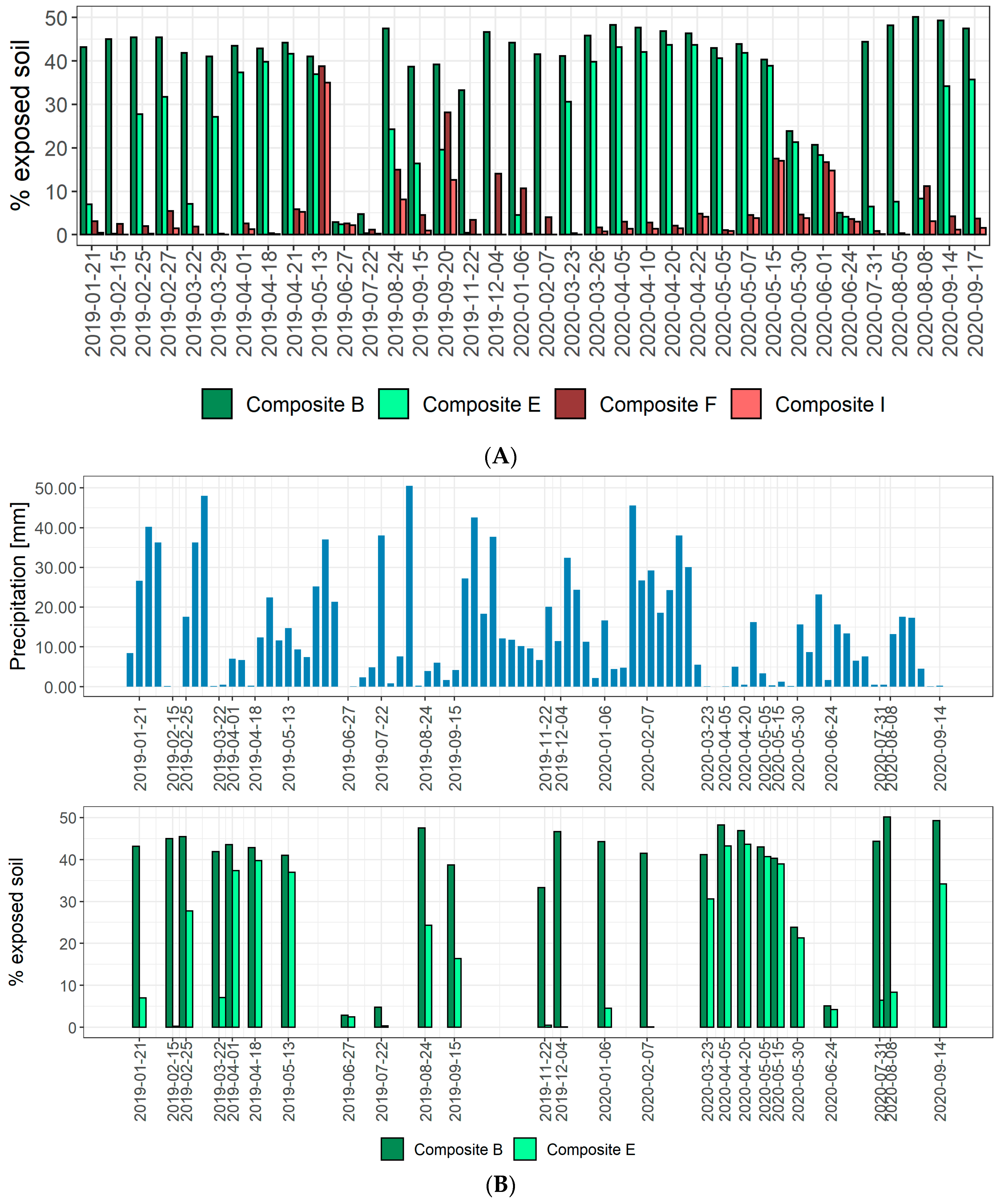
2.4. Methods for Creating Composites of Exposed Soils
2.4.1. Spectral Indices-Only Approach
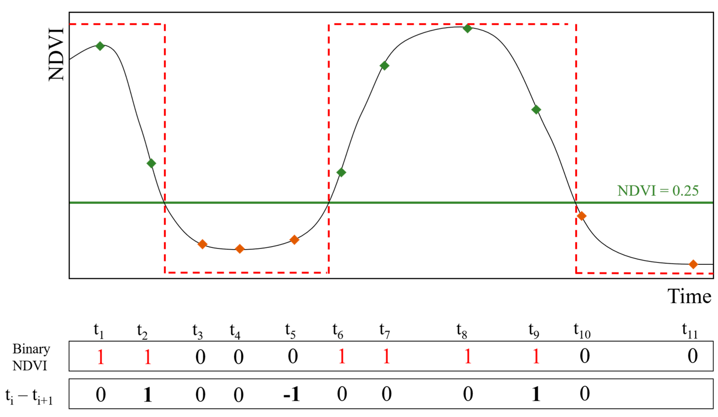
2.4.2. Greening-Up Approach
2.5. Composite Surface Cover
2.6. Spectral Models for SOC Prediction
3. Results
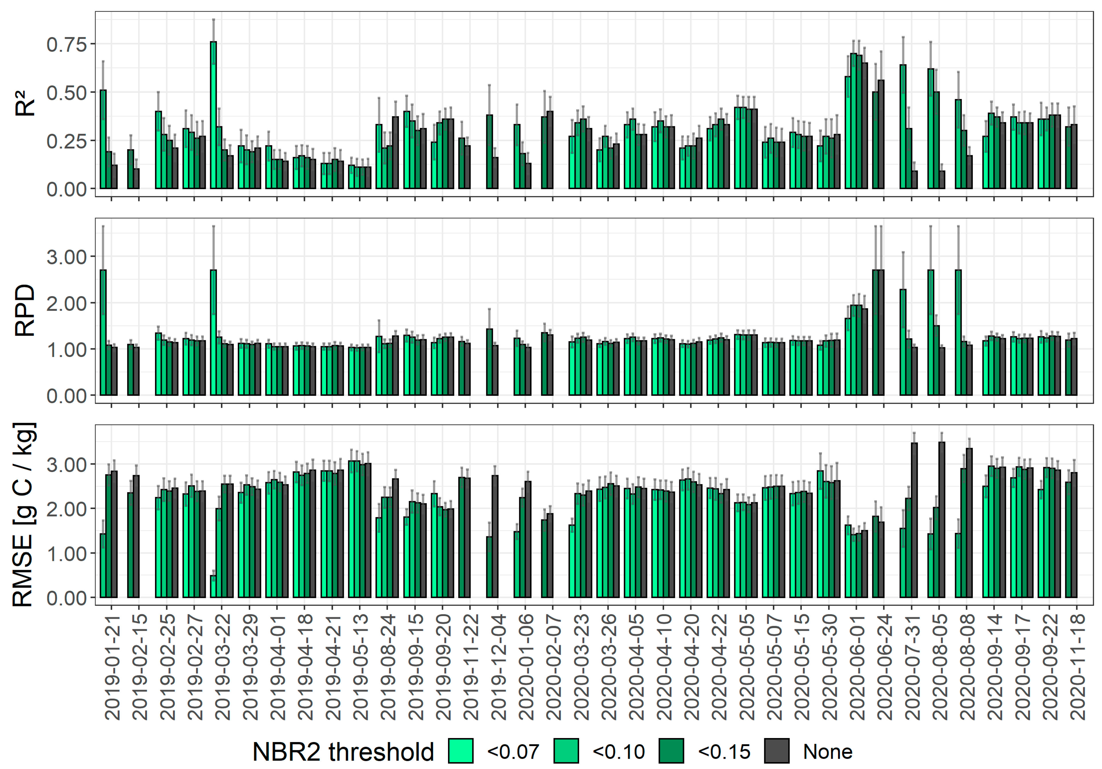
3.1. PLSR Models for Single S-2 Acquisition Dates
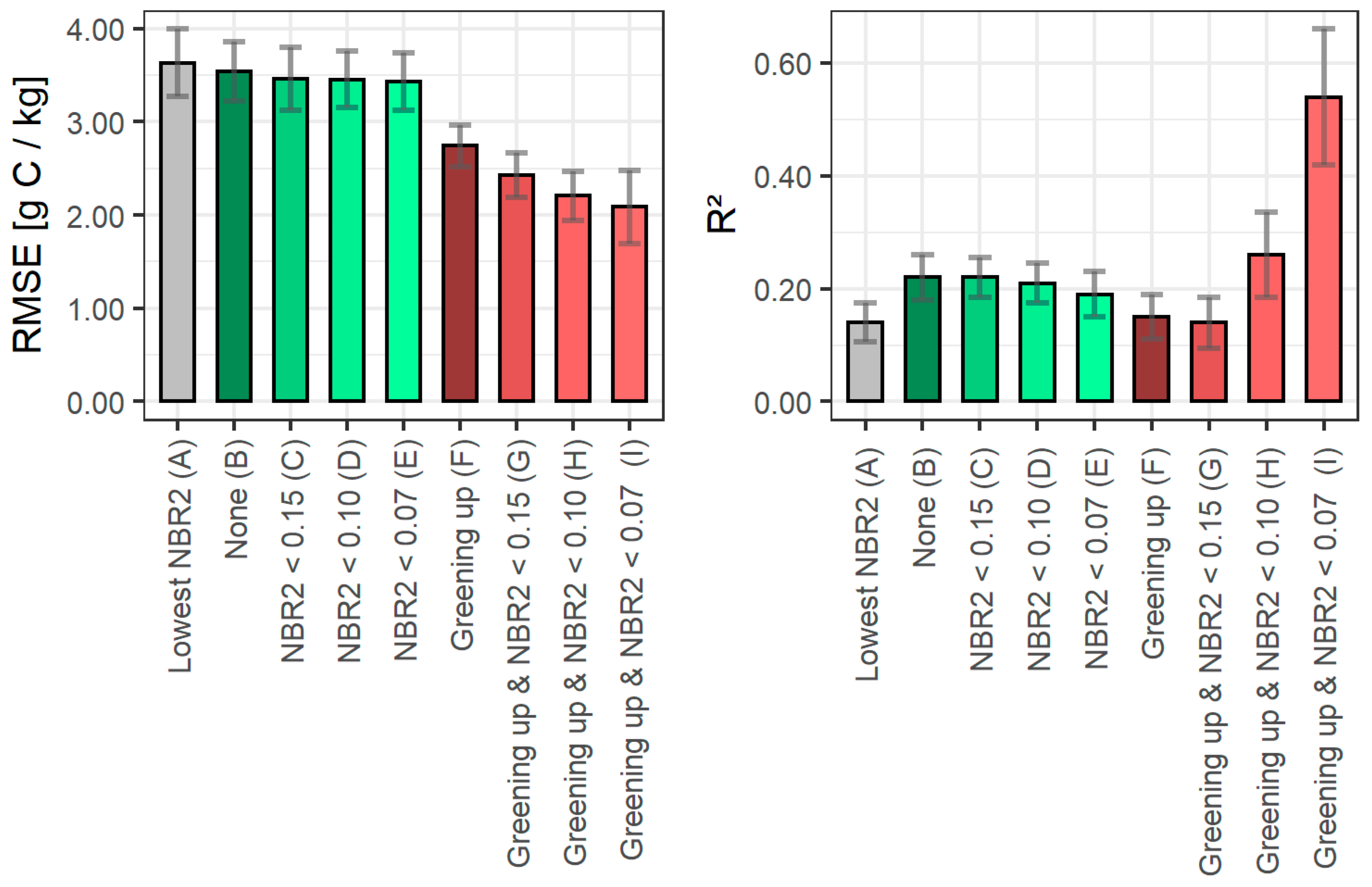
3.2. PLSR Models for S-2 Composites
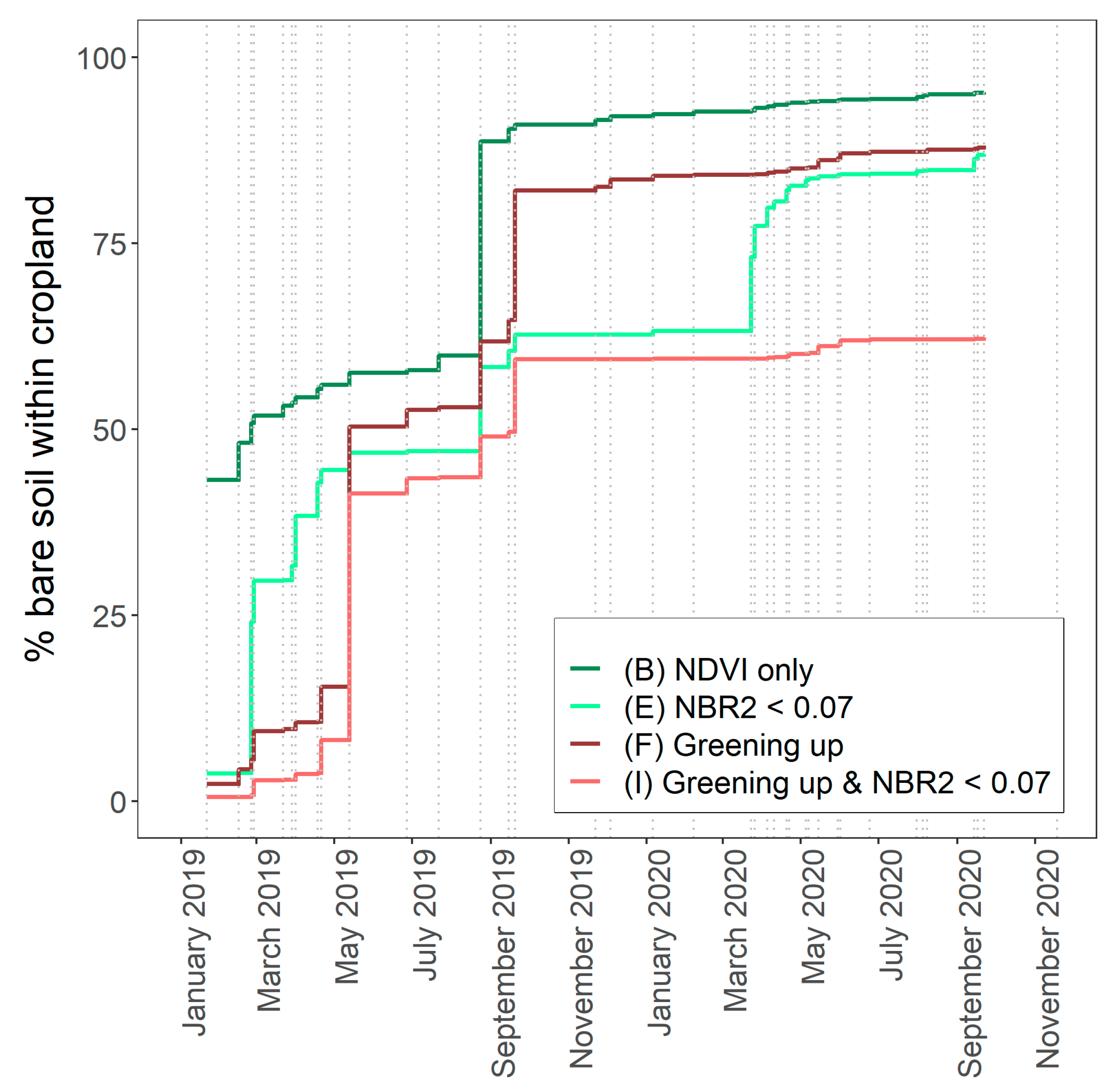
3.3. Surface Area Coverage by the Different Composites
4. Discussion
5. Conclusions
Author Contributions
Funding
Acknowledgments
Conflicts of Interest
References
- United Nations. SDG Indicator 15.3.1. Available online: https://knowledge.unccd.int/topics/sustainable-development-goals-sdgs/sdg-indicator-1531 (accessed on 14 March 2021).
- Nachtergaele, F.; Velthuizen, H.; Verelst, L.; Batjes, N.; Dijkshoorn, K.; Engelen, V.W.P.; Fischer, G.; Jones, A.; Montanarela, L.; Petri, M.; et al. The Harmonized World Soil Database; FAO: Rome, Italy; IIASA: Laxenburg, Austria, 2009; pp. 34–37. [Google Scholar]
- Chabrillat, S.; Ben-Dor, E.; Cierniewski, J.; Gomez, C.; Schmid, T.; van Wesemael, B. Imaging Spectroscopy for Soil Mapping and Monitoring. Surv. Geophys. 2019, 40, 361–399. [Google Scholar] [CrossRef]
- Castaldi, F.; Chabrillat, S.; Don, A.; van Wesemael, B. Soil Organic Carbon Mapping Using LUCAS Topsoil Database and Sentinel-2 Data: An Approach to Reduce Soil Moisture and Crop Residue Effects. Remote Sens. 2019, 11, 2121. [Google Scholar] [CrossRef]
- Castaldi, F.; Chabrillat, S.; Jones, A.; Vreys, K.; Bomans, B.; van Wesemael, B. Soil Organic Carbon Estimation in Croplands by Hyperspectral Remote APEX Data Using the LUCAS Topsoil Database. Remote Sens. 2018, 10, 153. [Google Scholar] [CrossRef]
- Castaldi, F.; Hueni, A.; Chabrillat, S.; Ward, K.; Buttafuoco, G.; Bomans, B.; Vreys, K.; Brell, M.; van Wesemael, B. Evaluating the capability of the Sentinel 2 data for soil organic carbon prediction in croplands. ISPRS J. Photogramm. Remote Sens. 2019, 147, 267–282. [Google Scholar] [CrossRef]
- Moura-Bueno, J.M.; Dalmolin, R.S.D.; ten Caten, A.; Dotto, A.C.; Demattê, J.A.M. Stratification of a local VIS-NIR-SWIR spectral library by homogeneity criteria yields more accurate soil organic carbon predictions. Geoderma 2019, 337, 565–581. [Google Scholar] [CrossRef]
- Guo, L.; Zhang, H.; Shi, T.; Chen, Y.; Jiang, Q.; Linderman, M. Prediction of soil organic carbon stock by laboratory spectral data and airborne hyperspectral images. Geoderma 2019, 337, 32–41. [Google Scholar] [CrossRef]
- Vaudour, E.; Gilliot, J.M.; Bel, L.; Lefevre, J.; Chehdi, K. Regional prediction of soil organic carbon content over temperate croplands using visible near-infrared airborne hyperspectral imagery and synchronous field spectra. Int. J. Appl. Earth Obs. Geoinf. 2016, 49, 24–38. [Google Scholar] [CrossRef]
- Vaudour, E.; Gomez, C.; Fouad, Y.; Lagacherie, P. Sentinel-2 image capacities to predict common topsoil properties of temperate and Mediterranean agroecosystems. Remote Sens. Environ. 2019, 223, 21–33. [Google Scholar] [CrossRef]
- Gholizadeh, A.; Žižala, D.; Saberioon, M.; Borůvka, L. Soil organic carbon and texture retrieving and mapping using proximal, airborne and Sentinel-2 spectral imaging. Remote Sens. Environ. 2018, 218, 89–103. [Google Scholar] [CrossRef]
- Drusch, M.; Del Bello, U.; Carlier, S.; Colin, O.; Fernandez, V.; Gascon, F.; Hoersch, B.; Isola, C.; Laberinti, P.; Martimort, P.; et al. Sentinel-2: ESA’s Optical High-Resolution Mission for GMES Operational Services. Remote Sens. Environ. 2012, 120, 25–36. [Google Scholar] [CrossRef]
- Ben-dor, E.; Inbar, Y.; Chen, Y. The reflectance spectra of the organic matter in the visible near infrared and the short wave infrared region during the controlled decomposition process. Remote Sens. Environ. 1997, 61, 1–15. [Google Scholar] [CrossRef]
- Diek, S.; Fornallaz, F.; Schapeman, M.; de Jong, R. Barest Pixel Composite for Agricultural Areas Using Landsat Time Series. Remote Sens. 2017, 9, 1245. [Google Scholar] [CrossRef]
- Rogge, D.; Bauer, A.; Zeidler, J.; Mueller, A.; Esch, T.; Heiden, U. Building an exposed soil composite processor (SCMaP) for mapping spatial and temporal characteristics of soils with Landsat imagery (1984–2014). Remote Sens. Environ. 2018, 205, 1–17. [Google Scholar] [CrossRef]
- Demattê, J.A.M.; Fongaro, C.T.; Rizzo, R.; Safanelli, J.L. Geospatial Soil Sensing System (GEOS3): A powerful data mining procedure to retrieve soil spectral reflectance from satellite images. Remote Sens. Environ. 2018, 212, 161–175. [Google Scholar] [CrossRef]
- Gallo, B.C.; Demattê, J.A.M.; Rizzo, R.; Safanelli, J.L.; Mendes, W.D.S.; Lepsch, I.F.; Sato, M.V.; Romero, D.J.; Lacerda, M.P.C. Multi-Temporal Satellite Images on Topsoil Attribute Quantification and the Relationship with Soil Classes and Geology. Remote Sens. 2018, 10, 1571. [Google Scholar] [CrossRef]
- Loiseau, T.; Chen, S.; Mulder, V.L.; Román Dobarco, M.; Richer-de-Forges, A.C.; Lehmann, S.; Bourennane, H.; Saby, N.P.A.; Martin, M.P.; Vaudour, E.; et al. Satellite data integration for soil clay content modelling at a national scale. Int. J. Appl. Earth Obs. Geoinf. 2019, 82, 101905. [Google Scholar] [CrossRef]
- Vaudour, E.; Gomez, C.; Lagacherie, P.; Loiseau, T.; Baghdadi, N.; Urbina-Salazar, D.; Loubet, B.; Arrouays, D. Temporal mosaicking approaches of Sentinel-2 images for extending topsoil organic carbon content mapping in croplands. Int. J. Appl. Earth Obs. Geoinf. 2021, 96, 102277. [Google Scholar] [CrossRef]
- El Hajj, M.; Baghdadi, N.; Zribi, M.; Bazzi, H. Synergic Use of Sentinel-1 and Sentinel-2 Images for Operational Soil Moisture Mapping at High Spatial Resolution over Agricultural Areas. Remote Sens. 2017, 9, 1292. [Google Scholar] [CrossRef]
- Vaudour, E.; Gomez, C.; Loiseau, T.; Baghdadi, N.; Loubet, B.; Arrouays, D.; Ali, L.; Lagacherie, P. The Impact of Acquisition Date on the Prediction Performance of Topsoil Organic Carbon from Sentinel-2 for Croplands. Remote Sens. 2019, 11, 2143. [Google Scholar] [CrossRef]
- Musick, H.B.; Pelletier, R.E. Response to soil moisture of spectral indexes derived from bidirectional reflectance in thematic mapper wavebands. Remote Sens. Environ. 1988, 25, 167–184. [Google Scholar] [CrossRef]
- Daughtry, C.; Hunt, E. Mitigating the effects of soil and residue water contents on remotely sensed estimates of crop residue cover. Remote Sens. Environ. 2008, 112, 1647–1657. [Google Scholar] [CrossRef]
- Dvorakova, K.; Shi, P.; Limbourg, Q.; van Wesemael, B. Soil Organic Carbon Mapping from Remote Sensing: The Effect of Crop Residues. Remote Sens. 2020, 12, 1913. [Google Scholar] [CrossRef]
- Liu, C.; Zhang, Q.; Tao, S.; Qi, J.; Ding, M.; Guan, Q.; Wu, B.; Zhang, M.; Nabil, M.; Tian, F.; et al. A new framework to map fine resolution cropping intensity across the globe: Algorithm, validation, and implication. Remote Sens. Environ. 2020, 251, 112095. [Google Scholar] [CrossRef]
- IWG Wrb. World Reference Base for Soil Resources 2014: International Soil Classification System for Naming Soils and Creating Legends for Soil Maps; FAO: Rome, Italy; IIASA: Laxenburg, Austria, 2014. [Google Scholar]
- Shi, P.; Castaldi, F.; van Wesemael, B.; Van Oost, K. Vis-NIR spectroscopic assessment of soil aggregate stability and aggregate size distribution in the Belgian Loam Belt. Geoderma 2020, 357, 113958. [Google Scholar] [CrossRef]
- Sherrod, L.A.; Dunn, G.; Peterson, G.; Kolberg, R. Inorganic Carbon Analysis by Modified Pressure-Calcimeter Method. Soil Sci. Soc. Am. J. 2002, 66. [Google Scholar] [CrossRef]
- Rouse, J.W.; Haas, R.H.; Scheel, J.A.; Deering, D.W. Monitoring Vegetation Systems in the Great Plains with ERTS. In Proceedings of the 3rd Earth Resource Technology Satellite (ERTS) Symposium, Washington, DC, USA, 10–14 December 1973; pp. 48–62. [Google Scholar]
- van Deventer, A.P.; Ward, A.D.; Gowda, P.H.; Lyon, J.G. Using Thematic Mapper Data to Identify Contrasting Soil Plains and Tillage Practices. Am. Soc. Photogramm. Remote Sens. 1997, 63, 87–93. [Google Scholar]
- Nocita, M.; Stevens, A.; Toth, G.; Panagos, P.; van Wesemael, B.; Montanarella, L. Prediction of soil organic carbon content by diffuse reflectance spectroscopy using a local partial least square regression approach. Soil Biol. Biochem. 2014, 68, 337–347. [Google Scholar] [CrossRef]
- Wold, S.; Sjöström, M.; Eriksson, L. PLS-regression: A basic tool of chemometrics. Chemom. Intell. Lab. Syst. 2001, 58, 109–130. [Google Scholar] [CrossRef]
- R Core Team. R: A Language and Environment for Statistical Computing; R Foundation for Statistical Computing: Vienna, Austria, 2014. [Google Scholar]
- Chang, C.-W.; Laird, D.A.; Mausbach, M.J.; Hurburgh, C.R. Near-Infrared Reflectance Spectroscopy–Principal Components Regression Analyses of Soil Properties Journal Paper no. J-18766 of the Iowa Agric. and Home Econ. Exp. Stn., Ames, IA. Soil Sci. Soc. Am. J. 2001, 65, 480–490. [Google Scholar] [CrossRef]
- Minasny, B. Why Calculating RPD Is Redundant; The Newsletter of the Pedometrics Commission of the International Union of Soil Sciences: Vienna, Austria, 2013. [Google Scholar]
- Efron, B.; Tibshirani, R.J. An Introduction to the Bootstrap; Chapman & Hall: New York, NY, USA; London, UK, 1993. [Google Scholar]
- Vašát, R.; Kodešová, R.; Klement, A.; Borůvka, L. Simple but efficient signal pre-processing in soil organic carbon spectroscopic estimation. Geoderma 2017, 298, 46–53. [Google Scholar] [CrossRef]
- Stevens, A.; Udelhoven, T.; Denis, A.; Tychon, B.; Lioy, R.; Hoffmann, L.; van Wesemael, B. Measuring soil organic carbon in croplands at regional scale using airborne imaging spectroscopy. Geoderma 2010, 158, 32–45. [Google Scholar] [CrossRef]
- Gomez, C.; Lagacherie, P.; Coulouma, G. Regional predictions of eight common soil properties and their spatial structures from hyperspectral Vis–NIR data. Geoderma 2012, 189–190, 176–185. [Google Scholar] [CrossRef]
- Vermote, E.; Justice, C.; Claverie, M.; Franch, B. Preliminary analysis of the performance of the Landsat 8/OLI land surface reflectance product. Remote Sens. Environ. 2016, 185, 46–56. [Google Scholar] [CrossRef] [PubMed]
- van Wesemael, B.; Chartin, C.; Wiesmeier, M.; von Lützow, M.; Hobley, E.; Carnol, M.; Krüger, I.; Campion, M.; Roisin, C.; Hennart, S.; et al. An indicator for organic matter dynamics in temperate agricultural soils. Agric. Ecosyst. Environ. 2019, 274, 62–75. [Google Scholar] [CrossRef]
- Žížala, D.; Minařík, R.; Zádorová, T. Soil Organic Carbon Mapping Using Multispectral Remote Sensing Data: Prediction Ability of Data with Different Spatial and Spectral Resolutions. Remote Sens. 2019, 11, 2947. [Google Scholar] [CrossRef]
- Tan, B.; Morisette, J.T.; Wolfe, R.E.; Gao, F.; Ederer, G.A.; Nightingale, J.; Pedelty, J.A. An Enhanced TIMESAT Algorithm for Estimating Vegetation Phenology Metrics from MODIS Data. IEEE J. Sel. Top. Appl. Earth Obs. Remote Sens. 2011, 4, 361–371. [Google Scholar] [CrossRef]


| Spectral Band | Spectral Domain | Central Wavelength (nm) | Bandwidth (nm) | Spatial Resolution (m) | ||
|---|---|---|---|---|---|---|
| S-2A | S-2B | S-2A | S-2B | |||
| B1 | Vis | 442.7 | 552.2 | 66 | 66 | 60 |
| B2 | Vis | 492.4 | 492.1 | 36 | 36 | 10 |
| B3 | Vis | 559.8 | 559.0 | 31 | 31 | 10 |
| B4 | Vis | 664.6 | 664.9 | 106 | 106 | 10 |
| B5 | R-edge | 704.1 | 703.8 | 15 | 16 | 20 |
| B6 | R-edge | 740.5 | 739.1 | 15 | 15 | 20 |
| B7 | R-edge | 782.8 | 779.7 | 20 | 20 | 20 |
| B8 | NIR | 832.8 | 832.9 | 21 | 22 | 10 |
| B8A | NIR | 864.7 | 864.0 | 91 | 94 | 20 |
| B9 | NIR | 945.1 | 943.2 | 175 | 185 | 60 |
| B10 | SWIR | 1373.5 | 1376.9 | 21 | 21 | 60 |
| B11 | SWIR | 1613.7 | 1610.4 | 20 | 21 | 20 |
| B12 | SWIR | 2202.4 | 2185.7 | 31 | 30 | 20 |
| BinaryNDVIti | BinaryNDVIt(i+1) | BinaryNDVIti − BinaryNDVIt(i+1) |
|---|---|---|
| Exposed soil (0) | Exposed soil (0) | 0 |
| Vegetation (1) | Exposed soil (0) | 1 |
| Vegetation (1) | Vegetation (1) | 0 |
| Exposed soil (0) | Vegetation (1) | −1 |
| Composite | A | B | C | D | E | F | G | H | I |
|---|---|---|---|---|---|---|---|---|---|
| A | - | ||||||||
| B | 1.000 | - | |||||||
| C | 1.000 | 1.000 | - | ||||||
| D | 0.666 | 0.666 | 0.666 | - | |||||
| E | 0.332 | 0.332 | 0.332 | 0.592 | - | ||||
| F | 0.390 | 0.390 | 0.390 | 0.641 | 0.979 | - | |||
| G | 0.048 | 0.048 | 0.048 | 0.098 | 0.207 | 0.278 | - | ||
| H | 0.114 | 0.114 | 0.114 | 0.193 | 0.338 | 0.339 | 0.881 | - | |
| I | 0.890 | 0.890 | 0.890 | 0.705 | 0.495 | 0.495 | 0.117 | 0.141 | - |
| Descriptive Statistics | Tenfold-Cross-Validation | |||||||||
|---|---|---|---|---|---|---|---|---|---|---|
| Composite | Criteria | n | Min * | Max * | Mean * | STD * | CV (%) | RMSE * | R2 | RPD |
| A | Lowest NBR2 | 128 | 6.7 | 22.1 | 12.3 | 3.4 | 27.3 | 3.63 ± 0.36 | 0.14 ± 0.03 | 1.06 ± 0.06 |
| B | NDVI < 0.25 | 128 | 6.7 | 22.1 | 12.3 | 3.4 | 27.3 | 3.54 ± 0.32 | 0.22 ± 0.04 | 1.12 ± 0.07 |
| C | NDVI < 0.25 and NBR2 < 0.15 | 127 | 6.7 | 22.1 | 12.3 | 3.4 | 27.3 | 3.46 ± 0.34 | 0.22 ± 0.04 | 1.12 ± 0.06 |
| D | NDVI < 0.25 and NBR2 < 0.10 | 126 | 6.7 | 22.1 | 12.2 | 3.2 | 26.6 | 3.45 ± 0.30 | 0.21 ± 0.04 | 1.12 ± 0.06 |
| E | NDVI < 0.25 and NBR2 < 0.07 | 123 | 6.7 | 21.4 | 12.1 | 3.1 | 25.4 | 3.43 ± 0.31 | 0.19 ± 0.04 | 1.10 ± 0.07 |
| F | Greening-up | 108 | 7.4 | 20.2 | 11.7 | 3.1 | 25.4 | 2.74 ± 0.23 | 0.15 ± 0.04 | 1.06 ± 0.08 |
| G | Greening-up and NBR2 < 0.15 | 91 | 7.4 | 20.2 | 11.6 | 2.7 | 22.9 | 2.43 ± 0.24 | 0.14 ± 0.05 | 1.06 ± 0.08 |
| H | Greening-up and NBR2 < 0.10 | 68 | 7.4 | 20.2 | 11.6 | 2.7 | 22.8 | 2.21 ± 0.27 | 0.26 ± 0.08 | 1.14 ± 0.08 |
| I | Greening-up and NBR2 < 0.07 | 49 | 8.0 | 20.2 | 11.3 | 3.2 | 25.7 | 2.09 ± 0.39 | 0.54 ± 0.12 | 1.68 ± 0.45 |
Publisher’s Note: MDPI stays neutral with regard to jurisdictional claims in published maps and institutional affiliations. |
© 2021 by the authors. Licensee MDPI, Basel, Switzerland. This article is an open access article distributed under the terms and conditions of the Creative Commons Attribution (CC BY) license (https://creativecommons.org/licenses/by/4.0/).
Share and Cite
Dvorakova, K.; Heiden, U.; van Wesemael, B. Sentinel-2 Exposed Soil Composite for Soil Organic Carbon Prediction. Remote Sens. 2021, 13, 1791. https://doi.org/10.3390/rs13091791
Dvorakova K, Heiden U, van Wesemael B. Sentinel-2 Exposed Soil Composite for Soil Organic Carbon Prediction. Remote Sensing. 2021; 13(9):1791. https://doi.org/10.3390/rs13091791
Chicago/Turabian StyleDvorakova, Klara, Uta Heiden, and Bas van Wesemael. 2021. "Sentinel-2 Exposed Soil Composite for Soil Organic Carbon Prediction" Remote Sensing 13, no. 9: 1791. https://doi.org/10.3390/rs13091791
APA StyleDvorakova, K., Heiden, U., & van Wesemael, B. (2021). Sentinel-2 Exposed Soil Composite for Soil Organic Carbon Prediction. Remote Sensing, 13(9), 1791. https://doi.org/10.3390/rs13091791