Detecting and Analyzing the Evolution of Subsidence Due to Coal Fires in Jharia Coalfield, India Using Sentinel-1 SAR Data
Abstract
1. Introduction
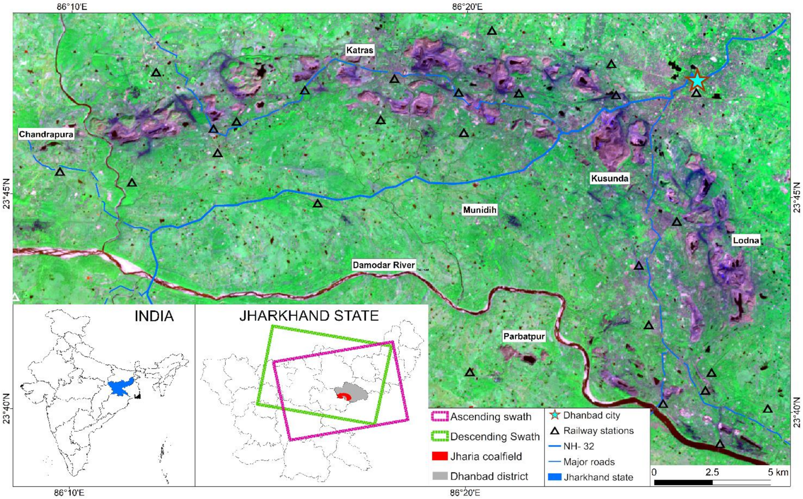
2. Study Area
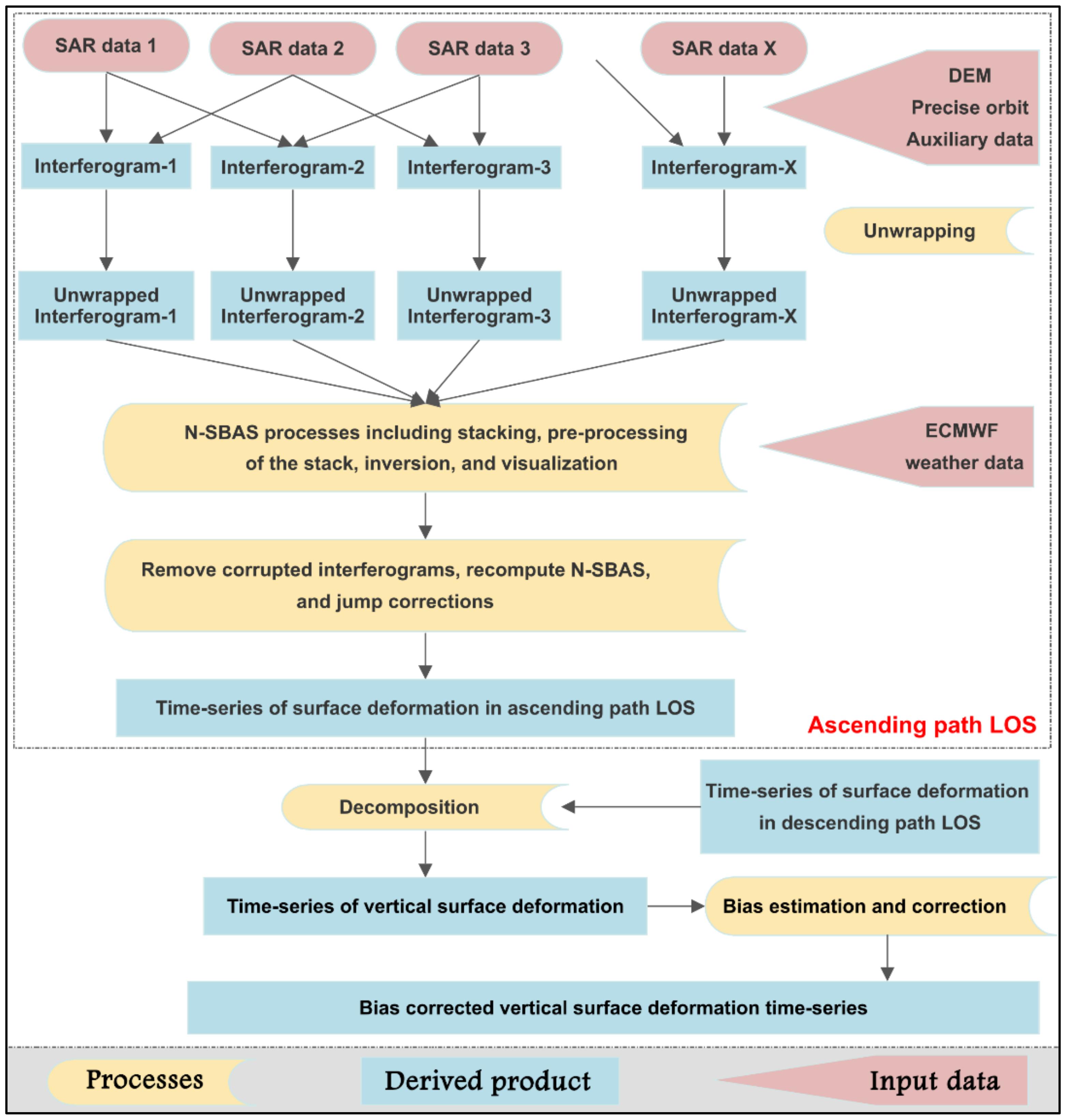
3. Methods and Materials
3.1. Interferometry
3.2. Surface Deformation Time-Series
3.3. Decomposition
3.4. Thermal Anomaly Mapping
4. Results
4.1. Surface Deformation Time-Series
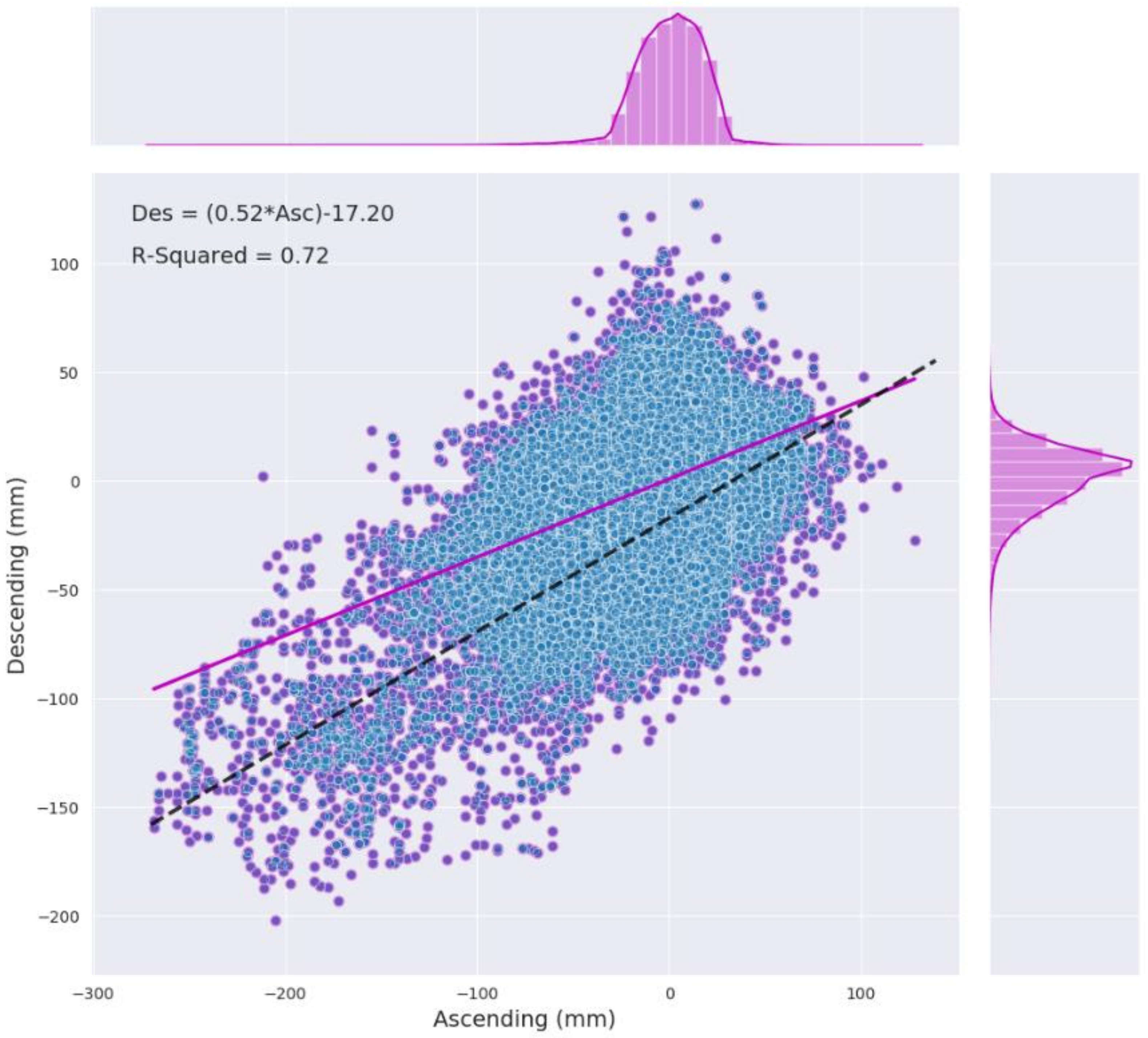
4.2. Decomposition
4.3. Temporal Variations
4.4. Coal Fire Mapping Using TIR Image
4.5. Vulnerability Assessment
5. Discussion
6. Conclusions
Author Contributions
Funding
Data Availability Statement
Acknowledgments
Conflicts of Interest
Appendix A
Appendix B

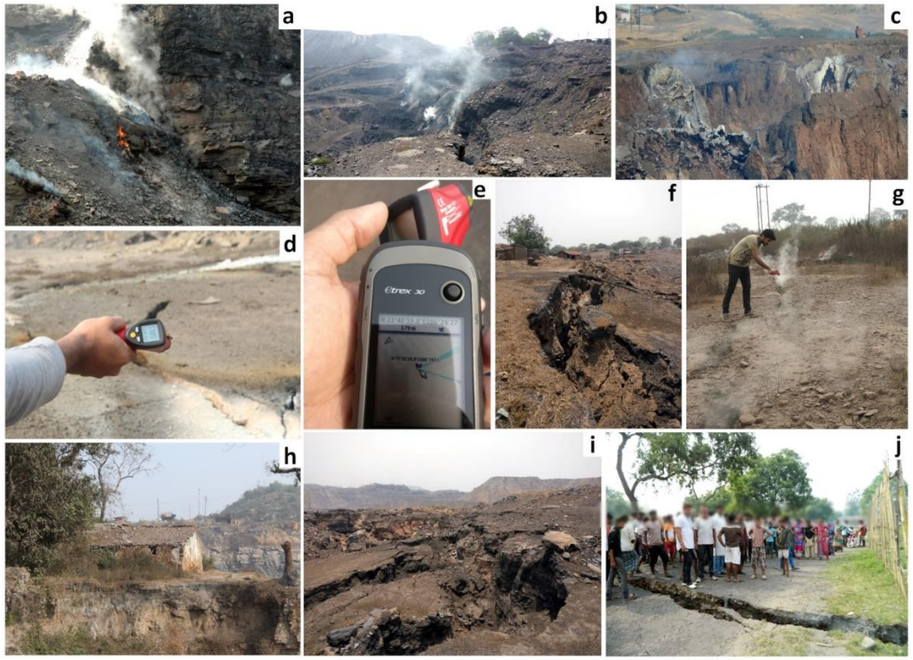
Appendix C
References
- Stracher, G.B.; Prakash, A.; Sokol, E.V. Coal and Peat Fires: A Global Perspective, 1st ed.; Elsevier: Amsterdam, The Netherlands, 2010; Volume 1, ISBN 978-0-444-52858-2. [Google Scholar]
- Dias, C.L.; Oliveira, M.L.S.; Hower, J.C.; Taffarel, S.R.; Kautzmann, R.M.; Silva, L.F.O. Nanominerals and Ultrafine Particles from Coal Fires from Santa Catarina, South Brazil. Int. J. Coal Geol. 2014, 122, 50–60. [Google Scholar] [CrossRef]
- Stracher, G.B.; Prakash, A.; Sokol, E.V. Coal and Peat Fires: A Global Perspective; Elsevier: Amsterdam, The Netherlands, 2012; Volume 2, ISBN 978-0-444-59412-9. [Google Scholar]
- Kim, A.G. Coal Formation and the Origin of Coal Fires. In Coal and Peat Fires: A Global Perspective; Stracher, G.B., Prakash, A., Sokol, E.V., Eds.; Elsevier: Amsterdam, The Netherlands, 2011; Chapter 1; Volume 1, pp. 1–28. ISBN 978-0-444-52858-2. [Google Scholar]
- Stracher, G.B.; Taylor, T.P. The Effects of Global Coal Fires. In Coal and Peat Fires: A Global Perspective; Stracher, G.B., Prakash, A., Sokol, E.V., Eds.; Elsevier: Amsterdam, The Netherlands, 2011; Chapter 6; Volume 1, pp. 101–114. ISBN 978-0-444-52858-2. [Google Scholar]
- Finkelman, R.B. Potential Health Impacts of Burning Coal Beds and Waste Banks. Int. J. Coal Geol. 2004, 59, 19–24. [Google Scholar] [CrossRef]
- Kuenzer, C.; Zhang, J.; Tetzlaff, A.; van Dijk, P.; Voigt, S.; Mehl, H.; Wagner, W. Uncontrolled Coal Fires and Their Environmental Impacts: Investigating Two Arid Mining Regions in North-Central China. Appl. Geogr. 2007, 27, 42–62. [Google Scholar] [CrossRef]
- Künzer, C. Remote and In Situ Mapping of Coal Fires: Case Studies from China and India. In Coal and Peat Fires: A Global Perspective; Stracher, G.B., Prakash, A., Sokol, E.V., Eds.; Elsevier: Amsterdam, The Netherlands, 2015; Chapter 3; Volume 3, pp. 57–93. ISBN 978-0-444-59509-6. [Google Scholar]
- Pandey, J.; Kumar, D.; Singh, V.K.; Mohalik, N.K. Environmental and Socio-Economic Impacts of Fire in Jharia Coalfield, Jharkhand, India: An Appraisal. Curr. Sci. 2016, 110, 1639. [Google Scholar] [CrossRef]
- Prakash, A.; Fielding, E.J.; Gens, R.; Van Genderen, J.L.; Evans, D.L. Data Fusion for Investigating Land Subsidence and Coal Fire Hazards in a Coal Mining Area. Int. J. Remote Sens. 2001, 22, 921–932. [Google Scholar] [CrossRef]
- Syed, T.H.; Riyas, M.J.; Kuenzer, C. Remote Sensing of Coal Fires in India: A Review. Earth Sci. Rev. 2018, 187, 338–355. [Google Scholar] [CrossRef]
- Song, Z.; Kuenzer, C. Coal Fires in China over the Last Decade: A Comprehensive Review. Int. J. Coal Geol. 2014, 133, 72–99. [Google Scholar] [CrossRef]
- Saini, V.; Gupta, R.P.; Arora, M.K. Environmental Impact Studies in Coalfields in India: A Case Study from Jharia Coal-Field. Renew. Sustain. Energy Rev. 2016, 53, 1222–1239. [Google Scholar] [CrossRef]
- Adhikary, T.; Bhattacharji, M.; Krishna Ghosh, A. Quality of Life Analysis: Socio-Economic Perspective with Reference to Jharia Coalfield. IOSR J. Humanit. Soc. Sci. 2014, 19, 33–45. [Google Scholar] [CrossRef]
- Stracher, G.B.; Taylor, T.P. Coal Fires Burning out of Control around the World: Thermodynamic Recipe for Environmental Catastrophe. Int. J. Coal Geol. 2004, 59, 7–17. [Google Scholar] [CrossRef]
- Ghosh, R.; Gupta, P.K.; Tolpekin, V.; Srivastav, S.K. An Enhanced Spatiotemporal Fusion Method—Implications for Coal Fire Monitoring Using Satellite Imagery. Int. J. Appl. Earth Obs. Geoinf. 2020, 88, 102056. [Google Scholar] [CrossRef]
- Kuenzer, C.; Zhang, J.; Li, J.; Voigt, S.; Mehl, H.; Wagner, W. Detecting Unknown Coal Fires: Synergy of Automated Coal Fire Risk Area Delineation and Improved Thermal Anomaly Extraction. Int. J. Remote Sens. 2007, 28, 4561–4585. [Google Scholar] [CrossRef]
- Prakash, A.; Schaefer, K.; Witte, W.K.; Collins, K.; Gens, R.; Goyette, M.P. A Remote Sensing and GIS Based Investigation of a Boreal Forest Coal Fire. Int. J. Coal Geol. 2011, 86, 79–86. [Google Scholar] [CrossRef]
- Liu, J.; Wang, Y.; Li, Y.; Dang, L.; Liu, X.; Zhao, H.; Yan, S. Underground Coal Fires Identification and Monitoring Using Time-Series InSAR With Persistent and Distributed Scatterers: A Case Study of Miquan Coal Fire Zone in Xinjiang, China. IEEE Access 2019, 7, 164492–164506. [Google Scholar] [CrossRef]
- Zhou, L.; Zhang, D.; Wang, J.; Huang, Z.; Pan, D. Mapping Land Subsidence Related to Underground Coal Fires in the Wuda Coalfield (Northern China) Using a Small Stack of ALOS PALSAR Differential Interferograms. Remote Sens. 2013, 5, 1152–1176. [Google Scholar] [CrossRef]
- Elick, J.M. Mapping the Coal Fire at Centralia, Pa Using Thermal Infrared Imagery. Int. J. Coal Geol. 2011, 87, 197–203. [Google Scholar] [CrossRef]
- Gangopadhyay, P.K.; Lahiri-Dutt, K.; Saha, K. Application of Remote Sensing to Identify Coalfires in the Raniganj Coalbelt, India. Int. J. Appl. Earth Obs. Geoinf. 2006, 8, 188–195. [Google Scholar] [CrossRef]
- Huo, H.; Ni, Z.; Gao, C.; Zhao, E.; Zhang, Y.; Lian, Y.; Zhang, H.; Zhang, S.; Jiang, X.; Song, X.; et al. A Study of Coal Fire Propagation with Remotely Sensed Thermal Infrared Data. Remote Sens. 2015, 7, 3088–3113. [Google Scholar] [CrossRef]
- Kuenzer, C.; Zhang, J.; Jing, L.; Huadong, G.; Dech, S. Thermal Infrared Remote Sensing of Surface and Underground Coal Fires. In Thermal Infrared Remote Sensing (Remote Sensing and Digital Image Processing); Kuenzer, C., Dech, S., Eds.; Springer: Dordrecht, The Netherlands, 2013; Volume 17, pp. 429–451. ISBN 978-94-007-6638-9. [Google Scholar]
- Kuenzer, C.; Stracher, G.B. Geomorphology of Coal Seam Fires. Geomorphology 2012, 138, 209–222. [Google Scholar] [CrossRef]
- Saini, V.; Gupta, R.P.; Arora, M.K. Spatio-Temporal Pattern of Eco-Environmental Parameters in Jharia Coalfield, India. In Proceedings of the Earth Resources and Environmental Remote Sensing/GIS Applications VI, Toulouse, France, 21–24 September 2015; Michel, U., Schulz, K., Ehlers, M., Nikolakopoulos, K.G., Civco, D., Eds.; SPIE: Toulouse, France, 2015; Volume 9644, pp. 276–281. [Google Scholar]
- Chatterjee, R.S. Coal Fire Mapping from Satellite Thermal IR Data—A Case Example in Jharia Coalfield, Jharkhand, India. ISPRS J. Photogr. Remote Sens. 2006, 60, 113–128. [Google Scholar] [CrossRef]
- Zhang, J.; Wagner, W.; Prakash, A.; Mehl, H.; Voigt, S. Detecting Coal Fires Using Remote Sensing Techniques. Int. J. Remote Sens. 2004, 25, 3193–3220. [Google Scholar] [CrossRef]
- Zhang, J.; Kuenzer, C.; Tetzlaff, A.; Oertel, D.; Zhukov, B.; Wagner, W. Thermal Characteristics of Coal Fires 2: Results of Measurements on Simulated Coal Fires. J. Appl. Geophys. 2007, 63, 135–147. [Google Scholar] [CrossRef]
- Zhang, J.; Kuenzer, C. Thermal Surface Characteristics of Coal Fires 1 Results of In-Situ Measurements. J. Appl. Geophys. 2007, 63, 117–134. [Google Scholar] [CrossRef]
- Kuenzer, C.; Hecker, C.; Zhang, J.; Wessling, S.; Wagner, W. The Potential of Multidiurnal MODIS Thermal Band Data for Coal Fire Detection. Int. J. Remote Sens. 2008, 29, 923–944. [Google Scholar] [CrossRef]
- Prakash, A.; Gens, R. Remote Sensing of Coal Fires. In Coal and Peat Fires: A Global Perspective; Elsevier: Amsterdam, The Netherlands, 2011; pp. 231–253. ISBN 978-0-444-52858-2. [Google Scholar]
- Song, Z.; Kuenzer, C.; Zhu, H.; Zhang, Z.; Jia, Y.; Sun, Y.; Zhang, J. Analysis of Coal Fire Dynamics in the Wuda Syncline Impacted by Fire-Fighting Activities Based on in-Situ Observations and Landsat-8 Remote Sensing Data. Int. J. Coal Geol. 2015, 141–142, 91–102. [Google Scholar] [CrossRef]
- Voigt, S.; Tetzlaff, A.; Zhang, J.; Künzer, C.; Zhukov, B.; Strunz, G.; Oertel, D.; Roth, A.; van Dijk, P.; Mehl, H. Integrating Satellite Remote Sensing Techniques for Detection and Analysis of Uncontrolled Coal Seam Fires in North China. Int. J. Coal Geol. 2004, 59, 121–136. [Google Scholar] [CrossRef]
- Wessling, S.; Kuenzer, C.; Kessels, W.; Wuttke, M.W. Numerical Modeling for Analyzing Thermal Surface Anomalies Induced by Underground Coal Fires. Int. J. Coal Geol. 2008, 74, 175–184. [Google Scholar] [CrossRef]
- Song, Z.; Kuenzer, C. Spectral Reflectance (400–2500 Nm) Properties of Coals, Adjacent Sediments, Metamorphic and Pyrometamorphic Rocks in Coal-Fire Areas: A Case Study of Wuda Coalfield and Its Surrounding Areas, Northern China. Int. J. Coal Geol. 2017, 171, 142–152. [Google Scholar] [CrossRef]
- Zhang, C.; Qin, Q.; Chen, L.; Wang, N.; Zhao, S.; Hui, J. Rapid Determination of Coalbed Methane Exploration Target Region Utilizing Hyperspectral Remote Sensing. Int. J. Coal Geol. 2015, 150–151, 19–34. [Google Scholar] [CrossRef]
- Chatterjee, R.S.; Thapa, S.; Singh, K.B.; Varunakumar, G.; Raju, E.V.R. Detecting, Mapping and Monitoring of Land Subsidence in Jharia Coalfield, Jharkhand, India by Spaceborne Differential Interferometric SAR, GPS and Precision Levelling Techniques. J. Earth Syst. Sci. 2015, 124, 1359–1376. [Google Scholar] [CrossRef]
- Gupta, N.; Syed, T.H.; Athiphro, A. Monitoring Subsurface Coal Fires in Jharia Coalfield Using Observations of Land Subsidence from Differential Interferometric Synthetic Aperture Radar (DInSAR). J. Earth Syst. Sci. 2013, 122, 1249–1258. [Google Scholar] [CrossRef]
- Hoffmann, J.; Roth, A.; Tetzlaff, A.; Voigt, S. Detecting Coal Fires in China Using Differential Interferometric Synthetic Aperture Radar (InSAR). In Proceedings of the Fringe Symposium, Frascati, Italy, 1–5 December 2003; DLR-Beauftragter: Frascati, Italy, 2003. [Google Scholar]
- Bekaert, D.P.S.; Walters, R.J.; Wright, T.J.; Hooper, A.J.; Parker, D.J. Statistical Comparison of InSAR Tropospheric Correction Techniques. Remote sens. Environ. 2015, 170, 40–47. [Google Scholar] [CrossRef]
- Fattahi, H.; Amelung, F. InSAR Bias and Uncertainty Due to the Systematic and Stochastic Tropospheric Delay. J. Geophys. Res. Solid Earth 2015, 120, 8758–8773. [Google Scholar] [CrossRef]
- Even, M.; Schulz, K. InSAR Deformation Analysis with Distributed Scatterers: A Review Complemented by New Advances. Remote Sens. 2018, 10, 744. [Google Scholar] [CrossRef]
- Tang, P.; Chen, F.; Guo, H.; Tian, B.; Wang, X.; Ishwaran, N. Large-Area Landslides Monitoring Using Advanced Multi-Temporal InSAR Technique over the Giant Panda Habitat, Sichuan, China. Remote Sens. 2015, 7, 8925–8949. [Google Scholar] [CrossRef]
- Crosetto, M.; Monserrat, O.; Cuevas-González, M.; Devanthéry, N.; Crippa, B. Persistent Scatterer Interferometry: A Review. ISPRS J. Photogr. Remote Sens. 2016, 115, 78–89. [Google Scholar] [CrossRef]
- Hooper, A.; Bekaert, D.; Spaans, K.; Arıkan, M. Recent Advances in SAR Interferometry Time Series Analysis for Measuring Crustal Deformation. Tectonophysics 2012, 514–517, 1–13. [Google Scholar] [CrossRef]
- Osmanoğlu, B.; Sunar, F.; Wdowinski, S.; Cabral-Cano, E. Time Series Analysis of InSAR Data: Methods and Trends. ISPRS J. Photogr. Remote Sens. 2016, 115, 90–102. [Google Scholar] [CrossRef]
- Ma, C.; Cheng, X.; Yang, Y.; Zhang, X.; Guo, Z.; Zou, Y. Investigation on Mining Subsidence Based on Multi-Temporal InSAR and Time-Series Analysis of the Small Baseline Subset—Case Study of Working Faces 22201-1/2 in Bu’ertai Mine, Shendong Coalfield, China. Remote Sens. 2016, 8, 951. [Google Scholar] [CrossRef]
- Fuhrmann, T.; Garthwaite, M.C. Resolving Three-Dimensional Surface Motion with InSAR: Constraints from Multi-Geometry Data Fusion. Remote Sens. 2019, 11, 241. [Google Scholar] [CrossRef]
- Hu, J.; Ding, X.L.; Li, Z.W.; Zhang, L.; Zhu, J.J.; Sun, Q.; Gao, G.J. Vertical and Horizontal Displacements of Los Angeles from InSAR and GPS Time Series Analysis: Resolving Tectonic and Anthropogenic Motions. J. Geodyn. 2016, 99, 27–38. [Google Scholar] [CrossRef]
- Hu, J.; Li, Z.W.; Ding, X.L.; Zhu, J.J.; Zhang, L.; Sun, Q. Resolving Three-Dimensional Surface Displacements from InSAR Measurements: A Review. Earth Sci. Rev. 2014, 133, 1–17. [Google Scholar] [CrossRef]
- Pepe, A.; Solaro, G.; Calo, F.; Dema, C. A Minimum Acceleration Approach for the Retrieval of Multiplatform InSAR Deformation Time Series. IEEE J. Sel. Top. Appl. Earth Obs. Remote Sens. 2016, 9, 3883–3898. [Google Scholar] [CrossRef]
- Wang, Q.; Zhao, Q.; Ding, J.; Fedotov, A.A.; Badenko, V.; Liu, M.; Pepe, A. Investigation of the Ground Displacement in Saint Petersburg, Russia, Using Multiple-Track Differential Synthetic Aperture Radar Interferometry. Int. J. Appl. Earth Obs. Geoinf. 2020, 87, 102050. [Google Scholar] [CrossRef]
- Doin, M.-P.; Guillaso, S.; Jolivet, R.; Lasserre, C.; Lodge, F.; Ducret, G.; Grandin, R. Presentation of the Small Baseline NSBAS Processing Chain on a Case Example: The Etna Deformation Monitoring from 2003 to 2010 Using Envisat Data. In Proceedings of the Fringe Symposium, Frascati, Italy, 19–23 September 2011; HAL: Frascati, Italy, 2011; pp. 3434–3437. [Google Scholar]
- Berardino, P.; Fornaro, G.; Lanari, R.; Sansosti, E. A New Algorithm for Surface Deformation Monitoring Based on Small Baseline Differential SAR Interferograms. IEEE Trans. Geosci. Remote Sens. 2002, 40, 2375–2383. [Google Scholar] [CrossRef]
- Michalski, S.R. The Jharia Mine Fire Control Technical Assistance Project: An Analysis. Int. J. Coal Geol. 2004, 59, 83–90. [Google Scholar] [CrossRef]
- Mukhopadhyay, G.; Mukhopadhyay, S.K.; Roychowdhury, M.; Parui, P.K. Stratigraphic Correlation between Different Gondwana Basins of India. J. Geol. Soc. India 2010, 76, 251–266. [Google Scholar] [CrossRef]
- Roy, A.B.; Purohit, R. Geology of the Gondwana Supergroup. In Indian Shield; Roy, A.B., Purohit, R., Eds.; Elsevier: Amsterdam, The Netherlands, 2018; pp. 273–285. ISBN 978-0-12-809839-4. [Google Scholar]
- Singh, R.V.K. Spontaneous Heating and Fire in Coal Mines. Procedia Eng. 2013, 62, 78–90. [Google Scholar] [CrossRef]
- Fattahi, H.; Agram, P.; Simons, M. A Network-Based Enhanced Spectral Diversity Approach for TOPS Time-Series Analysis. IEEE Trans. Geosci. Remote Sens. 2017, 55, 777–786. [Google Scholar] [CrossRef]
- Chen, C.W.; Zebker, H.A. Two-Dimensional Phase Unwrapping with Use of Statistical Models for Cost Functions in Nonlinear Optimization. J. Opt. Soc. Am. A 2001, 18, 338–351. [Google Scholar] [CrossRef]
- The InSAR Scientific Computing Environment (ISCE): A Python Framework for Earth Science. Available online: https://agu.confex.com/agu/fm15/webprogram/Paper84336.html (accessed on 3 January 2020).
- Jolivet, R.; Grandin, R.; Lasserre, C.; Doin, M.-P.; Peltzer, G. Systematic InSAR Tropospheric Phase Delay Corrections from Global Meteorological Reanalysis Data. Geophys. Res. Lett. 2011, 38. [Google Scholar] [CrossRef]
- Wright, T.J. Toward Mapping Surface Deformation in Three Dimensions Using InSAR. Geophys. Res. Lett. 2004, 31, L01607. [Google Scholar] [CrossRef]
- Jin, L.; Funning, G.J. Testing the Inference of Creep on the Northern Rodgers Creek Fault, California, Using Ascending and Descending Persistent Scatterer InSAR Data. J. Geophys. Res. Solid Earth 2017, 122, 2373–2389. [Google Scholar] [CrossRef]
- Gangopadhyay, P.K.; Van der Meer, F.; Van Dijk, P.M.; Saha, K. Use of Satellite-Derived Emissivity to Detect Coalfire-Related Surface Temperature Anomalies in Jharia Coalfield, India. Int. J. Remote Sens. 2012, 33, 6942–6955. [Google Scholar] [CrossRef]
- Saraf, A.K.; Prakash, A.; Sengupta, S.; Gupta, R.P. Landsat-TM Data for Estimating Ground Temperature and Depth of Subsurface Coal Fire in the Jharia Coalfield, India. Int. J. Remote Sens. 1995, 16, 2111–2124. [Google Scholar] [CrossRef]
- Prakash, A.; Saraf, A.K.; Gupta, R.P.; Dutta, M.; Sundaram, R.M. Surface Thermal Anomalies Associated with Underground Fires in Jharia Coal Mines, India. Int. J. Remote Sens. 1995, 16, 2105–2109. [Google Scholar] [CrossRef]
- Martha, T.R.; Guha, A.; Kumar, K.V.; Kamaraju, M.V.V.; Raju, E.V.R. Recent Coal-Fire and Land-Use Status of Jharia Coalfield, India from Satellite Data. Int. J. Remote Sens. 2010, 31, 3243–3262. [Google Scholar] [CrossRef]
- BCCL. BCCL W J Area Overview. Available online: http://www.bcclweb.in/?page_id=1724 (accessed on 12 February 2021).
- Haghighi, M.H.; Motagh, M. Ground Surface Response to Continuous Compaction of Aquifer System in Tehran, Iran: Results from a Long-Term Multi-Sensor InSAR Analysis. Remote Sens. Environ. 2019, 221, 534–550. [Google Scholar] [CrossRef]
- Motagh, M.; Shamshiri, R.; Haghighi, M.H.; Wetzel, H.-U.; Akbari, B.; Nahavandchi, H.; Roessner, S.; Arabi, S. Quantifying Groundwater Exploitation Induced Subsidence in the Rafsanjan Plain, Southeastern Iran, Using InSAR Time-Series and in Situ Measurements. Eng. Geol. 2017, 218, 134–151. [Google Scholar] [CrossRef]
- Singh, P.K.; Tiwari, A.K.; Verma, P. Evaluation of Water Level Behavior in Coal-Mining Area, Adjacent Township, and District Areas of Jharkhand State, India. In Clean and Sustainable Groundwater in India; Saha, D., Marwaha, S., Mukherjee, A., Eds.; Springer Hydrogeology: Singapore, 2018; pp. 261–278. ISBN 978-981-10-4551-6. [Google Scholar]
- Verma, R.K.; Bhuin, N.C.; Mukhopadhyay, M. Geology, Structure and Tectonics of the Jharia Coalfield, India—A Three-Dimensional Model. Geoexploration 1979, 17, 305–324. [Google Scholar] [CrossRef]
- Lahiri-Dutt, K.; Williams, D.J. The Coal Cycle: Small-Scale Illegal Coal Supply in Eastern India. J. Resour. Energy Dev. 2005, 2, 93–105. [Google Scholar] [CrossRef]
- Yan, S.; Shi, K.; Li, Y.; Liu, J.; Zhao, H. Integration of Satellite Remote Sensing Data in Underground Coal Fire Detection: A Case Study of the Fukang Region, Xinjiang, China. Front. Earth Sci. 2020, 14, 1–12. [Google Scholar] [CrossRef]
- Michalski, S.R.; Custer, E.S.; Munshi, P.L. Investigation of the Jharia Coalfield Mine Fires—India. Am. Soc. Min. Reclam. 1997, 211–223. [Google Scholar] [CrossRef]
- Stracher, G.B. Evidence of Human Health Impacts From Uncontrolled Coal Fires in Jharia, India. In Coal and Peat Fires: A Global Perspective; Elsevier: Amsterdam, The Netherdlands, 2019; pp. 343–358. ISBN 978-0-12-849885-9. [Google Scholar]
- Mongabay. Available online: https://india.mongabay.com/2019/10/the-burning-coalfields-of-jharia-belch-poison-for-local-residents (accessed on 20 December 2020).
- Hindustan Times. Available online: https://www.hindustantimes.com/ranchi/earth-opens-up-to-swallow-man-son-in-jharkhand-coal-mining-zone/story-UzmosIjhgIiqHYnCXZgB6H.html (accessed on 23 December 2020).
- Wessling, S.; Kessels, W.; Schmidt, M.; Krause, U. Investigating Dynamic Underground Coal Fires by Means of Numerical Simulation. Geophys. J. Int. 2008, 172, 439–454. [Google Scholar] [CrossRef]
- Prakash, A.; Kumar, A.; Singh, K.B. Dynamic Subsidence Characteristics in Jharia Coalfield, India. Geotech. Geol. Eng. 2014, 32, 627–635. [Google Scholar] [CrossRef]
Publisher’s Note: MDPI stays neutral with regard to jurisdictional claims in published maps and institutional affiliations. |
© 2021 by the authors. Licensee MDPI, Basel, Switzerland. This article is an open access article distributed under the terms and conditions of the Creative Commons Attribution (CC BY) license (https://creativecommons.org/licenses/by/4.0/).
Share and Cite
Riyas, M.J.; Syed, T.H.; Kumar, H.; Kuenzer, C. Detecting and Analyzing the Evolution of Subsidence Due to Coal Fires in Jharia Coalfield, India Using Sentinel-1 SAR Data. Remote Sens. 2021, 13, 1521. https://doi.org/10.3390/rs13081521
Riyas MJ, Syed TH, Kumar H, Kuenzer C. Detecting and Analyzing the Evolution of Subsidence Due to Coal Fires in Jharia Coalfield, India Using Sentinel-1 SAR Data. Remote Sensing. 2021; 13(8):1521. https://doi.org/10.3390/rs13081521
Chicago/Turabian StyleRiyas, Moidu Jameela, Tajdarul Hassan Syed, Hrishikesh Kumar, and Claudia Kuenzer. 2021. "Detecting and Analyzing the Evolution of Subsidence Due to Coal Fires in Jharia Coalfield, India Using Sentinel-1 SAR Data" Remote Sensing 13, no. 8: 1521. https://doi.org/10.3390/rs13081521
APA StyleRiyas, M. J., Syed, T. H., Kumar, H., & Kuenzer, C. (2021). Detecting and Analyzing the Evolution of Subsidence Due to Coal Fires in Jharia Coalfield, India Using Sentinel-1 SAR Data. Remote Sensing, 13(8), 1521. https://doi.org/10.3390/rs13081521


