
Risk Factor Detection and Landslide Susceptibility Mapping Using Geo-Detector and Random Forest Models: The 2018 Hokkaido Eastern Iburi Earthquake


Abstract

1. Introduction
2. Materials and Methods
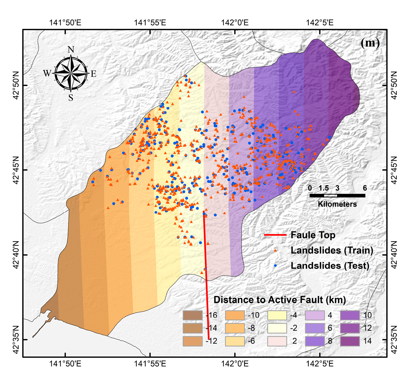
2.1. Study Area
2.2. Spatial Database
2.2.1. Landslide Inventory Map
2.2.2. Landslide Conditioning Factors
2.3. Methodology
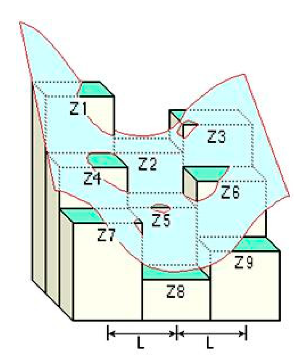
2.3.1. Geo-Detector
2.3.2. Dataset Generation Based on Geo-Detector
2.3.3. Random Forest Model
2.3.4. The Receiver Operating Characteristic Curve
3. Results
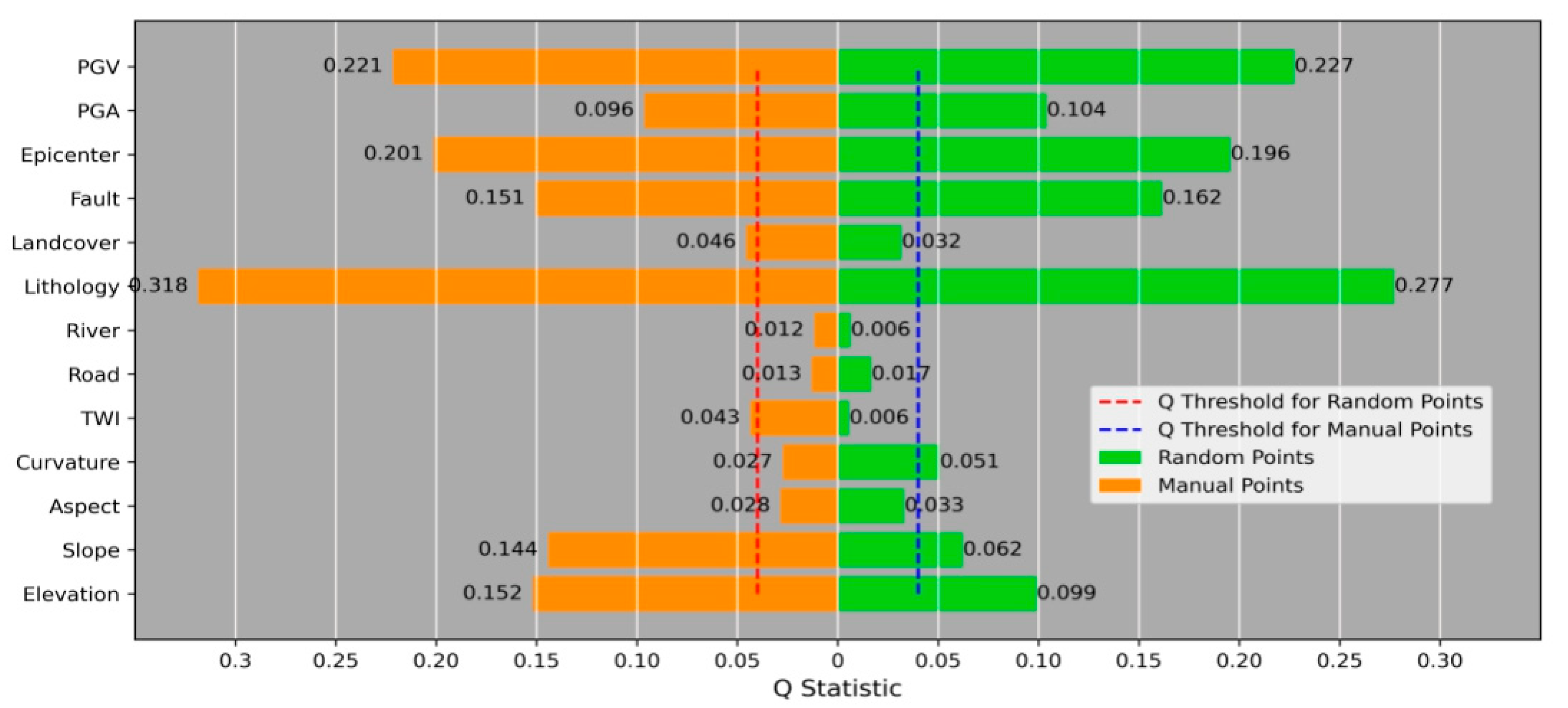
3.1. Geo-Detector and Dataset Generation
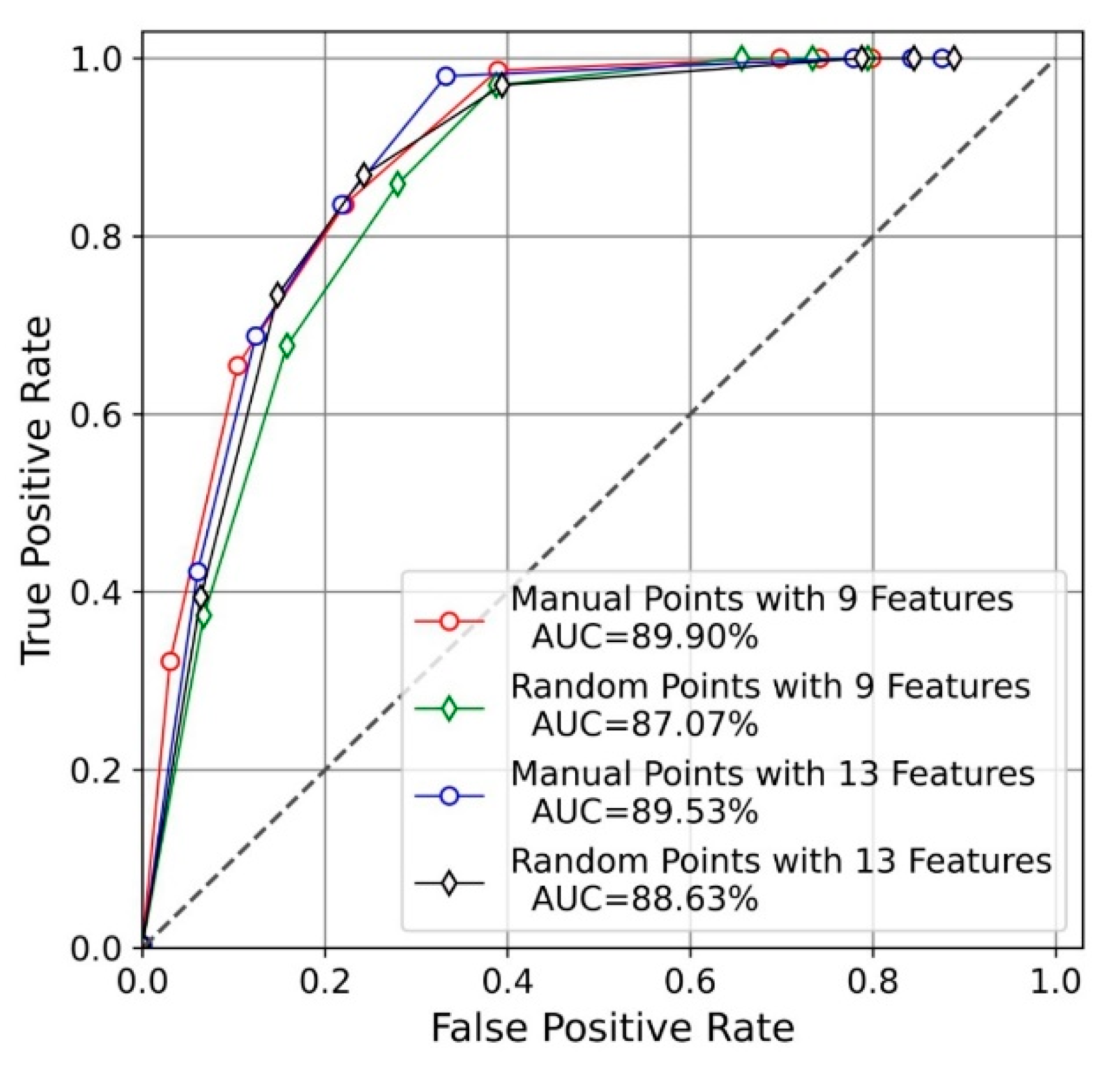
3.2. Model Accuracy Assessment and Comparison
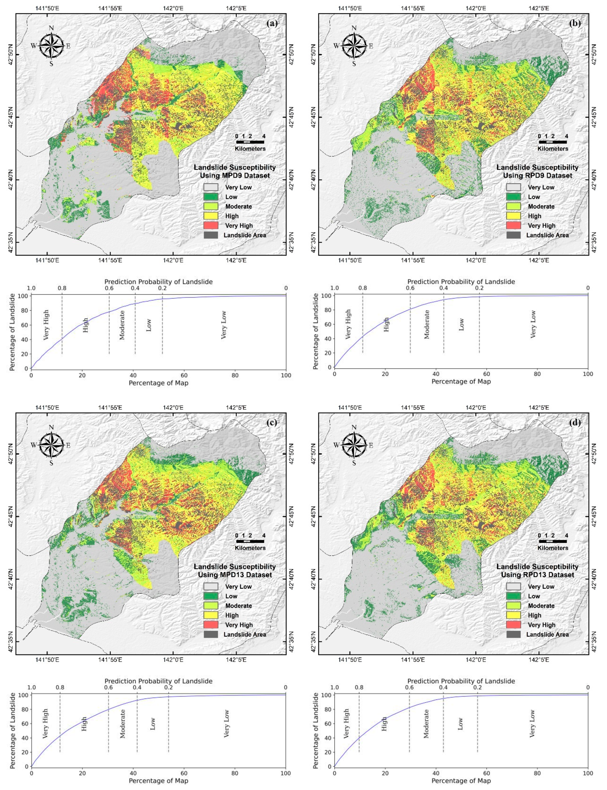
3.3. Landslide Susceptibility Mapping
4. Discussion
5. Conclusions
Author Contributions
Funding
Data Availability Statement
Acknowledgments
Conflicts of Interest
References
- Tien Bui, D.; Tuan, T.A.; Klempe, H.; Pradhan, B.; Revhaug, I. Spatial prediction models for shallow landslide hazards: A comparative assessment of the efficacy of support vector machines, artificial neural networks, kernel logistic regression, and logistic model tree. Landslides 2015, 13, 361–378. [Google Scholar] [CrossRef]
- Bălteanu, D.; Micu, M.; Jurchescu, M.; Malet, J.-P.; Sima, M.; Kucsicsa, G.; Dumitrică, C.; Petrea, D.; Mărgărint, M.C.; Bilaşco, Ş.; et al. National-scale landslide susceptibility map of Romania in a European methodological framework. Geomorphology 2020, 371. [Google Scholar] [CrossRef]
- Guzzetti, F.; Carrara, A.; Cardinali, M.; Reichenbach, P. Landslide hazard evaluation: A review of current techniques and their application in a multi-scale study, Central Italy. Geomorphology 1999, 31, 216. [Google Scholar] [CrossRef]
- Mărgărint, M.C.; Niculiţă, M. Landslide Type and Pattern in Moldavian Plateau, NE Romania. In Landform Dynamics and Evolution in Romania; Springer Geography; Springer: Cham, Switzerland, 2017; pp. 271–304. [Google Scholar] [CrossRef]
- Mărgărint, M.C.; Grozavu, A.; Patriche, C.V. Assessing the spatial variability of weights of landslide causal factors in different regions from Romania using logistic regression. Nat. Hazards Earth Syst. Sci. Discuss. 2013, 1, 1774. [Google Scholar] [CrossRef]
- Jebur, M.N.; Pradhan, B.; Tehrany, M.S. Optimization of landslide conditioning factors using very high-resolution airborne laser scanning (LiDAR) data at catchment scale. Remote Sens. Environ. 2014, 152, 150–165. [Google Scholar] [CrossRef]
- Reichenbach, P.; Rossi, M.; Malamud, B.D.; Mihir, M.; Guzzetti, F. A review of statistically-based landslide susceptibility models. Earth-Sci. Rev. 2018, 180, 60–91. [Google Scholar] [CrossRef]
- Luo, W.; Liu, C.-C. Innovative landslide susceptibility mapping supported by geomorphon and geographical detector methods. Landslides 2017, 15, 465–474. [Google Scholar] [CrossRef]
- van Westen, C.J.; Castellanos, E.; Kuriakose, S.L. Spatial data for landslide susceptibility, hazard, and vulnerability assessment: An overview. Eng. Geol. 2008, 102, 112–131. [Google Scholar] [CrossRef]
- Canli, E.; Thiebes, B.; Petschko, H.; Glade, T. Comparing physically-based and statistical landslide susceptibility model outputs—A case study from Lower Austria. In Proceedings of the EGU General Assembly 2015, Vienna, Austria, 12–17 April 2015. [Google Scholar]
- Pradhan, B.; Lee, S. Landslide susceptibility assessment and factor effect analysis: Backpropagation artificial neural networks and their comparison with frequency ratio and bivariate logistic regression modelling. Environ. Model. Softw. 2010, 25, 747–759. [Google Scholar] [CrossRef]
- Yang, J.; Song, C.; Yang, Y.; Xu, C.; Guo, F.; Xie, L. New method for landslide susceptibility mapping supported by spatial logistic regression and GeoDetector: A case study of Duwen Highway Basin, Sichuan Province, China. Geomorphology 2019, 324, 62–71. [Google Scholar] [CrossRef]
- Kavzoglu, T.; Sahin, E.K.; Colkesen, I. Landslide susceptibility mapping using GIS-based multi-criteria decision analysis, support vector machines, and logistic regression. Landslides 2013, 11, 425–439. [Google Scholar] [CrossRef]
- Yi, Y.; Zhang, Z.; Zhang, W.; Xu, Q.; Deng, C.; Li, Q. GIS-based earthquake-triggered-landslide susceptibility mapping with an integrated weighted index model in Jiuzhaigou region of Sichuan Province, China. Nat. Hazards Earth Syst. Sci. 2019, 19, 1973–1988. [Google Scholar] [CrossRef]
- Lee, S.; Pradhan, B. Landslide hazard mapping at Selangor, Malaysia using frequency ratio and logistic regression models. Landslides 2006, 4, 33–41. [Google Scholar] [CrossRef]
- Nefeslioglu, H.A.; Sezer, E.; Gokceoglu, C.; Bozkir, A.S.; Duman, T.Y. Assessment of Landslide Susceptibility by Decision Trees in the Metropolitan Area of Istanbul, Turkey. Math. Probl. Eng. 2010, 2010, 1–15. [Google Scholar] [CrossRef]
- Pradhan, B. A comparative study on the predictive ability of the decision tree, support vector machine and neuro-fuzzy models in landslide susceptibility mapping using GIS. Comput. Geosci. 2013, 51, 350–365. [Google Scholar] [CrossRef]
- Capecchi, V.; Perna, M.; Crisci, A. Statistical modelling of rainfall-induced shallow landsliding using static predictors and numerical weather predictions: Preliminary results. Nat. Hazards Earth Syst. Sci. 2015, 15, 75–95. [Google Scholar] [CrossRef]
- Fell, R.; Corominas, J.; Bonnard, C.; Leroi, E.; Cascini, L. Guidelines for landslide susceptibility, hazard and risk zoning for land use planning. Eng. Geol. 2008, 102, 83–84. [Google Scholar] [CrossRef]
- Guzzetti, F.; Ardizzone, F.; Cardinali, M.; Galli, M.; Reichenbach, P.; Rossi, M. Distribution of landslides in the Upper Tiber River basin, central Italy. Geomorphology 2008, 96, 105–122. [Google Scholar] [CrossRef]
- Donati, L.; Turrini, M.C. An objective method to rank the importance of the factors predisposing to landslides with the GIS methodology: Application to an area of the Apennines (Valnerina; Perugia, Italy). Eng. Geol. 2002, 63, 289. [Google Scholar] [CrossRef]
- Martínez-Álvarez, F.; Reyes, J.; Morales-Esteban, A.; Rubio-Escudero, C. Determining the best set of seismicity indicators to predict earthquakes. Two case studies: Chile and the Iberian Peninsula. Knowl.-Based Syst. 2013, 50, 198–210. [Google Scholar] [CrossRef]
- Fang, Z.; Wang, Y.; Peng, L.; Hong, H. Integration of convolutional neural network and conventional machine learning classifiers for landslide susceptibility mapping. Comput. Geosci. 2020, 139. [Google Scholar] [CrossRef]
- Jiménez-Perálvarez, J.D.; Irigaray, C.; El Hamdouni, R.; Chacón, J. Landslide-susceptibility mapping in a semi-arid mountain environment: An example from the southern slopes of Sierra Nevada (Granada, Spain). Bull. Eng. Geol. Environ. 2010, 70, 265–277. [Google Scholar] [CrossRef]
- Yamagishi, H.; Yamazaki, F. Landslides by the 2018 Hokkaido Iburi-Tobu Earthquake on September 6. Landslides 2018, 15, 2521–2524. [Google Scholar] [CrossRef]
- Shao, X.; Ma, S.; Xu, C.; Zhang, P.; Wen, B.; Tian, Y.; Zhou, Q.; Cui, Y. Planet Image-Based Inventorying and Machine Learning-Based Susceptibility Mapping for the Landslides Triggered by the 2018 Mw6.6 Tomakomai, Japan Earthquake. Remote Sens. 2019, 11, 978. [Google Scholar] [CrossRef]
- Moore, I.D.; Grayson, R.B.; Ladson, A.R. Digital terrain modelin—A review of hydrological, geomorphological, and biological applications. Hydrol. Process. 1991, 7, 18. [Google Scholar] [CrossRef]
- Zevenbergen, L.W.; Thorne, C.R. Quantitative Analysis of Land Surface Topography. Earth Surf. Process. Landf. 1987, 12, 56. [Google Scholar] [CrossRef]
- Quinn, P.F.; Beven, K.J.; Lamb, R. The in(a/tan/β) index: How to calculate it and how to use it within the topmodel framework. Hydrol. Process. 2010, 9, 22. [Google Scholar] [CrossRef]
- Falaschi, F.; Giacomelli, F.; Federici, P.R.; Puccinelli, A.; D’Amato Avanzi, G.; Pochini, A.; Ribolini, A. Logistic regression versus artificial neural networks: Landslide susceptibility evaluation in a sample area of the Serchio River valley, Italy. Nat. Hazards 2009, 50, 551–569. [Google Scholar] [CrossRef]
- Seamless Digital Geological Map of Japan. Available online: https://gbank.gsj.jp/seamless/index_en.html?p=download (accessed on 1 February 2021).
- Gong, P.; Liu, H.; Zhang, M.; Li, C.; Wang, J.; Huang, H.; Clinton, N.; Ji, L.; Li, W.; Bai, Y.; et al. Stable classification with limited sample: Transferring a 30-m resolution sample set collected in 2015 to mapping 10-m resolution global land cover in 2017. Sci. Bull. 2019, 64, 370–373. [Google Scholar] [CrossRef]
- Wang Jinfeng, X.C. Geo-detector: Principle and prospective. Acta Geogr. Sin. 2017, 72, 116–134. [Google Scholar] [CrossRef]
- Breiman, L.F.; Jerome, H.; Olshen, R.A.; Charles, J.C. Classification and Regression Trees; Wadsworth International Group: Wadsworth, OH, USA, 1984. [Google Scholar]
- Pedregosa, F.; Varoquaux, G.; Gramfort, A.; Michel, V.; Thirion, B.; Grisel, O.; Blondel, M.; Prettenhofer, P.; Weiss, R.; Dubourg, V.; et al. Scikit-learn: Machine Learning in Python. J. Mach. Learn. Res. 2011, 12, 2830. [Google Scholar]
- Breiman, L. Random forests. Mach. Learn. 2001, 45, 5–32. [Google Scholar] [CrossRef]
- Leo, B. Arcing Classifiers. Ann. Stat. 1999, 26, 801–849. [Google Scholar]
- Fawcett, T. An introduction to ROC analysis. Pattern Recognit. Lett. 2006, 27, 861–874. [Google Scholar] [CrossRef]
- Walter, S.D. Properties of the summary receiver operating characteristic (SROC) curve for diagnostic test data. Stat. Med. 2002, 21, 1237–1256. [Google Scholar] [CrossRef] [PubMed]
- Pradhan, B.; Lee, S. Regional landslide susceptibility analysis using back-propagation neural network model at Cameron Highland, Malaysia. Landslides 2009, 7, 13–30. [Google Scholar] [CrossRef]


| A | B | C | D | E | F | G | H | I |
|---|---|---|---|---|---|---|---|---|
| Datasets | Susceptibility | Pixels | Landslide Pixels | Density | Map Pixels | Percentage of Map | Map Landslide Pixels | Percentage of Landslide |
| (A) | (B) | (C) | (D) | (D/C) | (F) | (C/F) | (H) | (100D/H) |
| MPD9 | Very High | 54066 | 17339 | 0.32 | 574471 | 9.41 | 52190 | 33.22 |
| High | 132482 | 24693 | 0.19 | 574471 | 23.06 | 52190 | 47.31 | |
| Moderate | 55040 | 5476 | 0.10 | 574471 | 9.58 | 52190 | 10.49 | |
| Low | 52676 | 2599 | 0.05 | 574471 | 9.17 | 52190 | 4.98 | |
| Very Low | 280207 | 2083 | 0.01 | 574471 | 48.78 | 52190 | 3.99 | |
| RPD9 | Very High | 53832 | 19429 | 0.36 | 574471 | 9.37 | 52190 | 37.23 |
| High | 127100 | 24195 | 0.19 | 574471 | 22.12 | 52190 | 46.36 | |
| Moderate | 74226 | 6114 | 0.08 | 574471 | 12.92 | 52190 | 11.71 | |
| Low | 75861 | 1787 | 0.02 | 574471 | 13.21 | 52190 | 3.42 | |
| Very Low | 243452 | 665 | 0.00 | 574471 | 42.38 | 52190 | 1.27 | |
| MPD13 | Very High | 56965 | 20252 | 0.36 | 574471 | 9.92 | 52190 | 38.80 |
| High | 121146 | 22143 | 0.18 | 574471 | 21.09 | 52190 | 42.43 | |
| Moderate | 65411 | 6331 | 0.10 | 574471 | 11.39 | 52190 | 12.13 | |
| Low | 66750 | 2272 | 0.03 | 574471 | 11.62 | 52190 | 4.35 | |
| Very Low | 264199 | 1192 | 0.00 | 574471 | 45.99 | 52190 | 2.28 | |
| RPD13 | Very High | 47632 | 18392 | 0.39 | 574471 | 8.29 | 52190 | 35.24 |
| High | 131947 | 25964 | 0.20 | 574471 | 22.97 | 52190 | 49.75 | |
| Moderate | 73086 | 5671 | 0.08 | 574471 | 12.72 | 52190 | 10.87 | |
| Low | 71690 | 1608 | 0.02 | 574471 | 12.48 | 52190 | 3.08 | |
| Very Low | 250116 | 555 | 0.00 | 574471 | 43.54 | 52190 | 1.06 |
Publisher’s Note: MDPI stays neutral with regard to jurisdictional claims in published maps and institutional affiliations. |
© 2021 by the authors. Licensee MDPI, Basel, Switzerland. This article is an open access article distributed under the terms and conditions of the Creative Commons Attribution (CC BY) license (http://creativecommons.org/licenses/by/4.0/).
Share and Cite
Liu, Y.; Zhang, W.; Zhang, Z.; Xu, Q.; Li, W. Risk Factor Detection and Landslide Susceptibility Mapping Using Geo-Detector and Random Forest Models: The 2018 Hokkaido Eastern Iburi Earthquake. Remote Sens. 2021, 13, 1157. https://doi.org/10.3390/rs13061157
Liu Y, Zhang W, Zhang Z, Xu Q, Li W. Risk Factor Detection and Landslide Susceptibility Mapping Using Geo-Detector and Random Forest Models: The 2018 Hokkaido Eastern Iburi Earthquake. Remote Sensing. 2021; 13(6):1157. https://doi.org/10.3390/rs13061157
Chicago/Turabian StyleLiu, Yimo, Wanchang Zhang, Zhijie Zhang, Qiang Xu, and Weile Li. 2021. "Risk Factor Detection and Landslide Susceptibility Mapping Using Geo-Detector and Random Forest Models: The 2018 Hokkaido Eastern Iburi Earthquake" Remote Sensing 13, no. 6: 1157. https://doi.org/10.3390/rs13061157
APA StyleLiu, Y., Zhang, W., Zhang, Z., Xu, Q., & Li, W. (2021). Risk Factor Detection and Landslide Susceptibility Mapping Using Geo-Detector and Random Forest Models: The 2018 Hokkaido Eastern Iburi Earthquake. Remote Sensing, 13(6), 1157. https://doi.org/10.3390/rs13061157