
Improved Real-Time Natural Hazard Monitoring Using Automated DInSAR Time Series


Abstract
1. Introduction
2. Materials and Methods
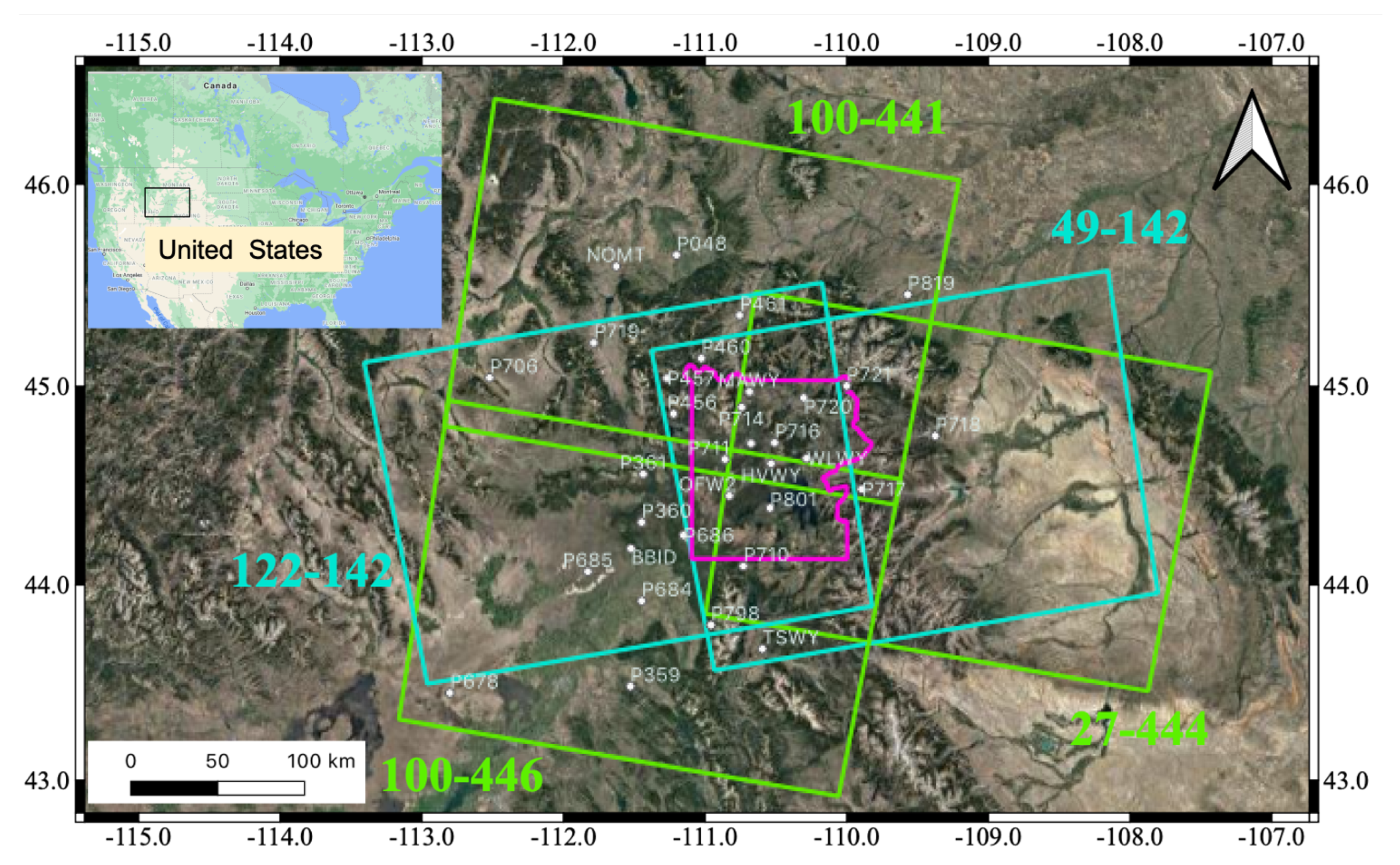
2.1. The Yellowstone and Hawaiian Volcanic Areas
2.2. DInSAR Data
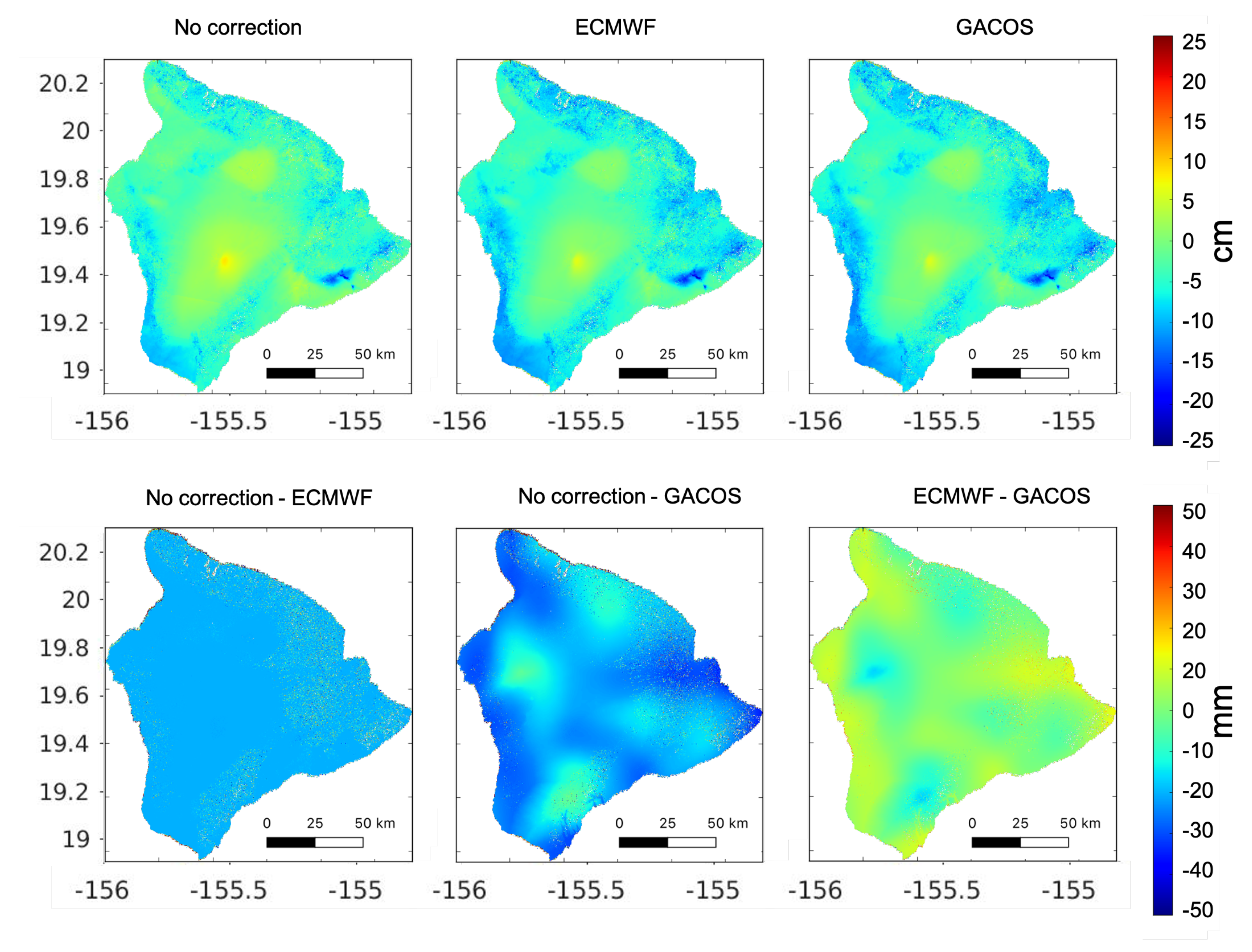
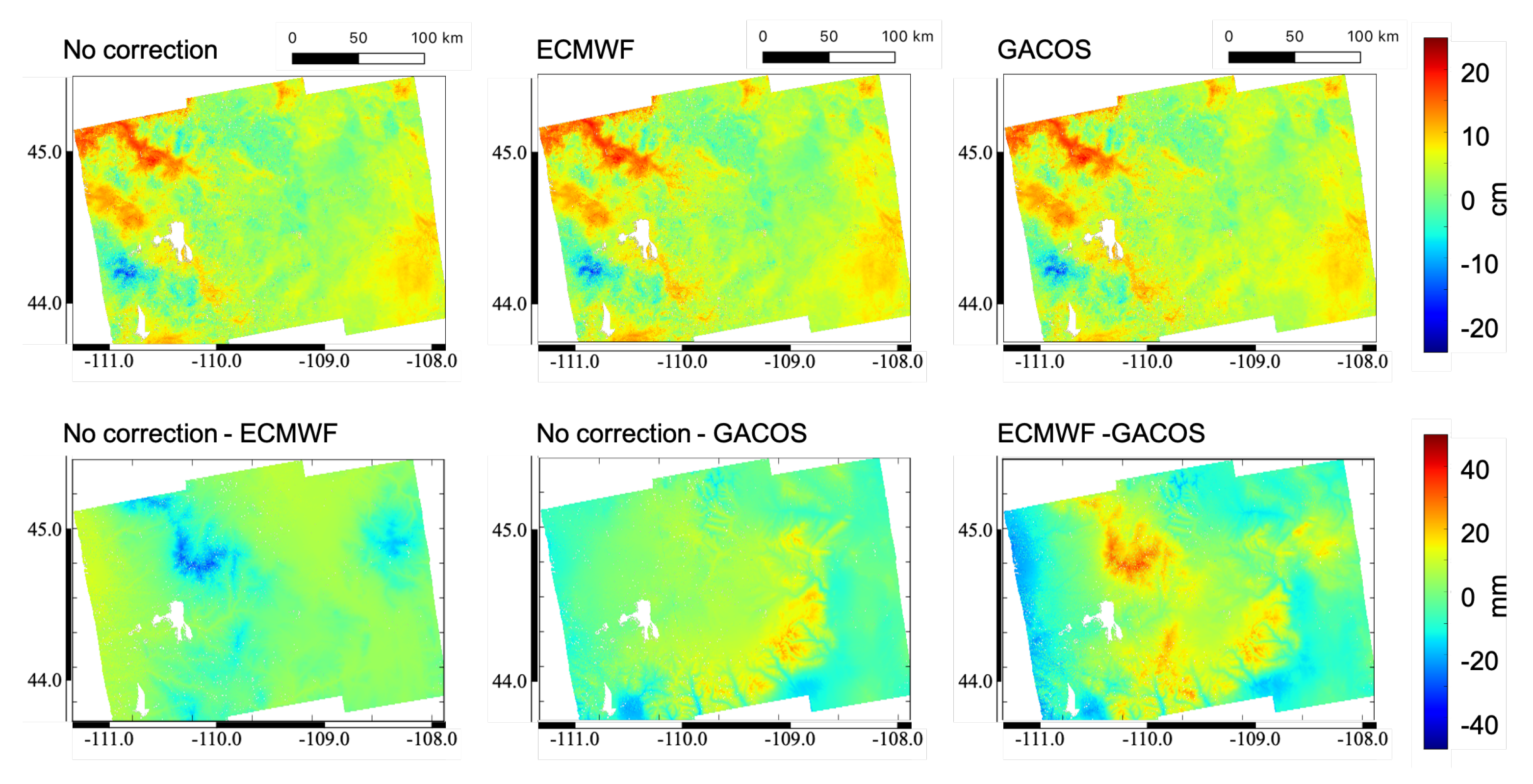
2.3. Atmospheric Correction and Displacement Time Series
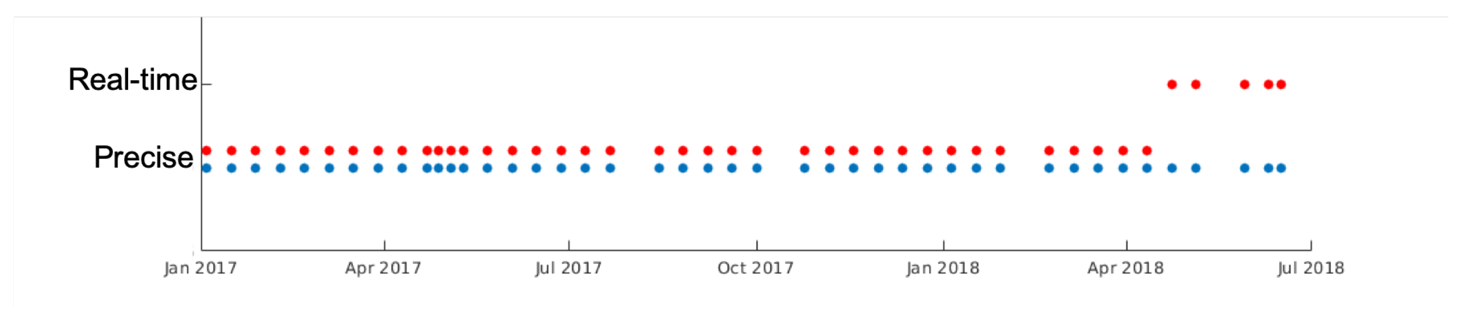
2.4. Real-time and Precise Orbits
3. Results
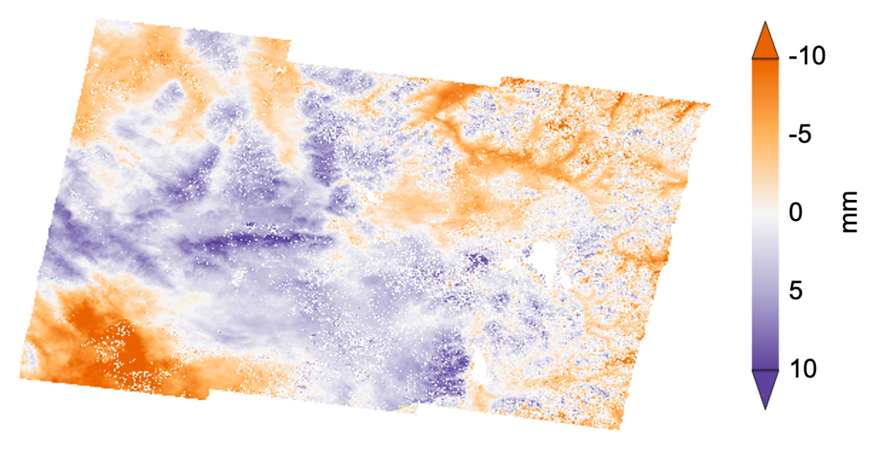
3.1. Atmospheric Correction
3.2. Real-Time and Precise Orbits
3.3. Yellowstone Results
4. Discussion
Author Contributions
Funding
Data Availability Statement
Acknowledgments
Conflicts of Interest
Appendix A. Examples of Interferograms from the Yellowstone Data Processing


References
- Tiampo, K.F.; McGinnis, S.; Kropivnitskaya, Y.; Qin, J.; Bauer, M.A. Big data challenges and hazards modeling. In Risk Modeling for Hazards and Disasters; Elsevier: Amsterdam, The Netherlands, 2018; pp. 193–210. [Google Scholar]
- Dzurisin, D. A comprehensive approach to monitoring volcano deformation as a window on the eruption cycle. Rev. Geophys. 2003, 41, 1001. [Google Scholar] [CrossRef]
- Aiuppa, A.; Moretti, R.; Federico, C.; Giudice, G.; Gurrieri, S.; Liuzzo, M.; Papale, P.; Shinohara, H.; Valenza, M. Forecasting Etna eruptions by real-time observation of volcanic gas composition. Geology 2007, 35, 1115–1118. [Google Scholar] [CrossRef]
- Marzocchi, W.; Sandri, L.; Selva, J. BET_EF: A probabilistic tool for long-and short-term eruption forecasting. Bull. Volcanol. 2008, 70, 623–632. [Google Scholar] [CrossRef]
- Marzocchi, W.; Garcia-Aristizabal, A.; Gasparini, P.; Mastellone, M.L.; Di Ruocco, A. Basic principles of multi-risk assessment: A case study in Italy. Nat. Hazards 2012, 62, 551–573. [Google Scholar] [CrossRef]
- Loughlin, S.C.; Sparks, R.S.J.; Sparks, S.; Brown, S.K.; Jenkins, S.F.; Vye-Brown, C. Global Volcanic Hazards and Risk; Cambridge University Press: Cambridge, UK, 2015. [Google Scholar]
- Newhall, C.G.; Pallister, J.S. Using multiple data sets to populate probabilistic volcanic event trees. In Volcanic Hazards, Risks and Disasters; Elsevier: Amsterdam, The Netherlands, 2015; pp. 203–232. [Google Scholar]
- Gaddes, M.; Hooper, A.; Bagnardi, M. Using machine learning to automatically detect volcanic unrest in a time series of interferograms. J. Geophys. Res. Solid Earth 2019, 124, 12304–12322. [Google Scholar] [CrossRef]
- Poland, M.P.; Anderson, K.R. Partly Cloudy With a Chance of Lava Flows: Forecasting Volcanic Eruptions in the Twenty-First Century. J. Geophys. Res. Solid Earth 2020, 125, e2018JB016974. [Google Scholar] [CrossRef]
- Massonnet, D.; Feigl, K.L. Radar interferometry and its application to changes in the Earth’s surface. Rev. Geophys. 1998, 36, 441–500. [Google Scholar] [CrossRef]
- Amelung, F.; Jónsson, S.; Zebker, H.; Segall, P. Widespread uplift and ?trapdoor?faulting on Galapagos volcanoes observed with radar interferometry. Nature 2000, 407, 993–996. [Google Scholar] [CrossRef]
- Wadge, G. A strategy for the observation of volcanism on Earth from space. Philos. Trans. R. Soc. London. Ser. Math. Phys. Eng. Sci. 2003, 361, 145–156. [Google Scholar] [CrossRef] [PubMed]
- Fernández, J.; Tizzani, P.; Manzo, M.; Borgia, A.; González, P.; Martí, J.; Pepe, A.; Camacho, A.; Casu, F.; Berardino, P.; et al. Gravity-driven deformation of Tenerife measured by InSAR time series analysis. Geophys. Res. Lett. 2009, 36, L04306. [Google Scholar] [CrossRef]
- Samsonov, S.V.; d’Oreye, N.; González, P.J.; Tiampo, K.F.; Ertolahti, L.; Clague, J.J. Rapidly accelerating subsidence in the Greater Vancouver region from two decades of ERS-ENVISAT-RADARSAT-2 DInSAR measurements. Remote. Sens. Environ. 2014, 143, 180–191. [Google Scholar] [CrossRef]
- Samsonov, S.V.; Feng, W.; Peltier, A.; Geirsson, H.; d?Oreye, N.; Tiampo, K.F. Multidimensional Small Baseline Subset (MSBAS) for volcano monitoring in two dimensions: Opportunities and challenges. Case study Piton de la Fournaise volcano. J. Volcanol. Geotherm. Res. 2017, 344, 121–138. [Google Scholar] [CrossRef]
- Hua, H.; Owen, S.E.; Yun, S.H.; Agram, P.S.; Manipon, G.; Starch, M.; Sacco, G.F.; Bue, B.D.; Dang, L.B.; Linick, J.P.; et al. Large-scale Sentinel-1 processing for solid earth science and urgent response using cloud computing and machine learning. AGUFM 2017, 2017, G33A-02. [Google Scholar]
- Bekaert, D.; Agram, P.; Owen, S.; Karim, M.; Dang, L.; Manipon, G.; Linick, J.; Hua, H.; Gurrola, E.; Simons, M.; et al. Development of Standardized Interferometric Products and Online Processing Capabilities. AGUFM 2018, 2018, G32A-02. [Google Scholar]
- Bekaert, D.P.; Karim, M.; Linick, J.P.; Hua, H.; Sangha, S.; Lucas, M.; Malarout, N.; Agram, P.S.; Pan, L.; Owen, S.E.; et al. Development of open-access Standardized InSAR Displacement Products by the Advanced Rapid Imaging and Analysis (ARIA) Project for Natural Hazards. AGUFM 2019, 2019, G23A-04. [Google Scholar]
- Meyer, F.J.; Arko, S.A.; Hogenson, K.; McAlpin, D.B.; Whitley, M.A. A cloud-based system for automatic hazard monitoring from Sentinel-1 SAR data. In Proceedings of the 2017 AGU Fall Meeting, New Orleans, LA, USA, 11–15 December 2017. [Google Scholar]
- Garron, J.; Stoner, C.; Meyer, F. Cloud-based oil detection processing pipeline prototype for C-band synthetic aperture radar data. In Proceedings of the OCEANS 2017-Anchorage, Aberdeen, UK, 18–21 September 2017; pp. 1–7. [Google Scholar]
- Logan, T.A.; Nicoll, J.B. Automated RTC and INSAR Stack-Processing at the Alaska Satellite Facility. In Proceedings of the 2018 AGU Fall Meeting, Washington, DC, USA, 10–14 December 2018. [Google Scholar]
- Wright, T.; Gonzalez, P.; Walters, R.; Hatton, E.; Spaans, K.; Hooper, A. LiCSAR: Tools for automated generation of Sentinel-1 frame interferograms. In Proceedings of the 2016 AGU Fall Meeting, San Francisco, CA, USA, 12–16 December 2016. [Google Scholar]
- Wright, T.J.; Hooper, A.J.; Spaans, K.; Hatton, E.L.; González, P.J.; Bhattarai, S.; Biggs, J.; Crippa, P.; Ebmeier, S.K.; Elliott, J.R.; et al. COMET-LICSAR: Systematic Deformation Monitoring of Fault Zones and Volcanoes with the Sentinel-1 Constellation. In Proceedings of the 2017 AGU Fall Meeting, New Orleans, LA, USA, 11–15 December 2017. [Google Scholar]
- Corsa, B.D.; Tiampo, K.F.; Kelevitz, K.; Baker, S.; Meertens, C. Automated Processing, Streaming, and Integration of InSAR Time Series and GNSS Data; as part of the Collaborative GeoSciFramework Research Project. AGUFM 2019, 2019, G13C-0574. [Google Scholar]
- Reath, K.; Pritchard, M.; Poland, M.; Delgado, F.; Carn, S.; Coppola, D.; Andrews, B.; Ebmeier, S.; Rumpf, E.; Henderson, S.; et al. Thermal, deformation, and degassing remote sensing time series (CE 2000–2017) at the 47 most active volcanoes in Latin America: Implications for volcanic systems. J. Geophys. Res. Solid Earth 2019, 124, 195–218. [Google Scholar] [CrossRef]
- Torres, R.; Snoeij, P.; Geudtner, D.; Bibby, D.; Davidson, M.; Attema, E.; Potin, P.; Rommen, B.; Floury, N.; Brown, M.; et al. GMES Sentinel-1 mission. Remote. Sens. Environ. 2012, 120, 9–24. [Google Scholar] [CrossRef]
- Berardino, P.; Fornaro, G.; Lanari, R.; Sansosti, E. A new algorithm for surface deformation monitoring based on small baseline differential SAR interferograms. IEEE Trans. Geosci. Remote. Sens. 2002, 40, 2375–2383. [Google Scholar] [CrossRef]
- Ferretti, A.; Prati, C.; Rocca, F. Permanent scatterers in SAR interferometry. IEEE Trans. Geosci. Remote. Sens. 2001, 39, 8–20. [Google Scholar] [CrossRef]
- Hooper, A. A multi-temporal InSAR method incorporating both persistent scatterer and small baseline approaches. Geophys. Res. Lett. 2008, 35, L16302. [Google Scholar] [CrossRef]
- Usai, S. A least squares database approach for SAR interferometric data. IEEE Trans. Geosci. Remote. Sens. 2003, 41, 753–760. [Google Scholar] [CrossRef]
- Corsa, B.; Tiampo, K.; Kelevitz, K.; Baker, S.; Meertens, C. Comparison of Insar Time Series Generation Techniques as Part of the Collaborative Geosciframework Research Project. In Proceedings of the 2020 AGU Fall Meeting, Online, 7–11 December 2020. [Google Scholar]
- Samsonov, S.; Tiampo, K. Analytical optimization of a DInSAR and GPS dataset for derivation of three-dimensional surface motion. IEEE Geosci. Remote. Sens. Lett. 2006, 3, 107–111. [Google Scholar] [CrossRef]
- Molteni, F.; Buizza, R.; Palmer, T.N.; Petroliagis, T. The ECMWF ensemble prediction system: Methodology and validation. Q. J. R. Meteorol. Soc. 1996, 122, 73–119. [Google Scholar] [CrossRef]
- Yu, C.; Li, Z.; Penna, N.T.; Crippa, P. Generic atmospheric correction model for Interferometric Synthetic Aperture Radar observations. J. Geophys. Res. Solid Earth 2018, 123, 9202–9222. [Google Scholar] [CrossRef]
- Zebker, H.A. User-friendly InSAR data products: Fast and simple timeseries processing. IEEE Geosci. Remote. Sens. Lett. 2017, 14, 2122–2126. [Google Scholar] [CrossRef]
- Christiansen, R.L. The Quaternary and Pliocene Yellowstone Plateau Volcanic Field of Wyoming, Idaho, and Montana; U.S. Geological Survey: Denver, CO, USA, 2001. [Google Scholar]
- Yuan, H.; Dueker, K. Teleseismic P-wave tomogram of the Yellowstone plume. Geophys. Res. Lett. 2005, 32, L07304. [Google Scholar] [CrossRef]
- Smith, R.B.; Jordan, M.; Steinberger, B.; Puskas, C.M.; Farrell, J.; Waite, G.P.; Husen, S.; Chang, W.L.; O’Connell, R. Geodynamics of the Yellowstone hotspot and mantle plume: Seismic and GPS imaging, kinematics, and mantle flow. J. Volcanol. Geotherm. Res. 2009, 188, 26–56. [Google Scholar] [CrossRef]
- Russo, E.; Waite, G.; Tibaldi, A. Evaluation of the evolving stress field of the Yellowstone volcanic plateau, 1988 to 2010, from earthquake first-motion inversions. Tectonophysics 2017, 700, 80–91. [Google Scholar] [CrossRef]
- Newhall, C.; Self, S.; Robock, A. Anticipating future Volcanic Explosivity Index (VEI) 7 eruptions and their chilling impacts. Geosphere 2018, 14, 572–603. [Google Scholar] [CrossRef]
- Chang, W.L.; Smith, R.B.; Farrell, J.; Puskas, C.M. An extraordinary episode of Yellowstone caldera uplift, 2004–2010, from GPS and InSAR observations. Geophys. Res. Lett. 2010, 37, L23302. [Google Scholar] [CrossRef]
- Waite, G.P.; Smith, R.B. Seismic evidence for fluid migration accompanying subsidence of the Yellowstone caldera. J. Geophys. Res. Solid Earth 2002, 107, ESE-1. [Google Scholar] [CrossRef]
- Chang, W.; Smith, R.; Wicks, C.; Puskas, C.; Farrell, J. Accelerated uplift and source models of the Yellowstone caldera, 2004–2006, from GPS and InSAR observations. Science 2007, 318, 952–956. [Google Scholar] [CrossRef] [PubMed]
- Sherrod, D.R.; Sinton, J.M.; Watkins, S.E.; Brunt, K.M. Geologic map of the State of Hawaii. US Geol. Surv. Open File Rep. 2007, 1089, 83. [Google Scholar]
- Quane, S.; Garcia, M.; Guillou, H.; Hulsebosch, T. Magmatic history of the East Rift Zone of Kilauea Volcano, Hawaii based on drill core from SOH 1. J. Volcanol. Geotherm. Res. 2000, 102, 319–338. [Google Scholar] [CrossRef]
- Holcomb, R.T. Eruptive history and long-term behavior of Kilauea Volcano. US Geol. Surv. Prof. Pap 1987, 1350, 261–350. [Google Scholar]
- Montgomery-Brown, E.K.; Sinnett, D.; Poland, M.; Segall, P.; Orr, T.; Zebker, H.; Miklius, A. Geodetic evidence for en echelon dike emplacement and concurrent slow slip during the June 2007 intrusion and eruption at Kīlauea volcano, Hawaii. J. Geophys. Res. Solid Earth 2010, 115, B07405. [Google Scholar] [CrossRef]
- Jung, H.S.; Lu, Z.; Won, J.S.; Poland, M.P.; Miklius, A. Mapping three-dimensional surface deformation by combining multiple-aperture interferometry and conventional interferometry: Application to the June 2007 eruption of Kilauea volcano, Hawaii. IEEE Geosci. Remote. Sens. Lett. 2010, 8, 34–38. [Google Scholar] [CrossRef]
- Sandwell, D.; Mellors, R.; Tong, X.; Wei, M.; Wessel, P. Open radar interferometry software for mapping surface deformation. Eos Trans. Am. Geophys. Union 2011, 92, 234. [Google Scholar] [CrossRef]
- Agram, P.S.; Jolivet, R.; Riel, B.; Lin, Y.N.; Simons, M.; Hetland, E.; Doin, M.-P.; Lasserre, C. New radar interferometric time series analysis toolbox released. Eos, Transactions American Geophysical Union 2013, 94, 69–70. [Google Scholar] [CrossRef]
- Ding, X.l.; Li, Z.w.; Zhu, J.j.; Feng, G.c.; Long, J.P. Atmospheric effects on InSAR measurements and their mitigation. Sensors 2008, 8, 5426–5448. [Google Scholar] [CrossRef]
- Hanssen, R.; Feijt, A. A first quantitative evaluation of atmospheric effects on SAR interferometry. Ers Sar Interferom. 1997, 406, 277. [Google Scholar]
- Zebker, H.A.; Rosen, P.A.; Hensley, S. Atmospheric effects in interferometric synthetic aperture radar surface deformation and topographic maps. J. Geophys. Res. Solid Earth 1997, 102, 7547–7563. [Google Scholar] [CrossRef]
- Li, Z.; Ding, X.; Huang, C.; Wadge, G.; Zheng, D. Modeling of atmospheric effects on InSAR measurements by incorporating terrain elevation information. J. Atmos. Sol. Terr. Phys. 2006, 68, 1189–1194. [Google Scholar] [CrossRef]
- Li, Z.; Fielding, E.J.; Cross, P.; Muller, J.P. Interferometric synthetic aperture radar atmospheric correction: GPS topography-dependent turbulence model. J. Geophys. Res. Solid Earth 2006, 111, B02404. [Google Scholar] [CrossRef]
- Webley, P.; Wadge, G.; James, I. Determining radio wave delay by non-hydrostatic atmospheric modelling of water vapour over mountains. Phys. Chem. Earth Parts A B C 2004, 29, 139–148. [Google Scholar] [CrossRef]
- Li, Z.; Muller, J.P.; Cross, P. Tropospheric correction techniques in repeat-pass SAR interferometry. In Proceedings of the FRINGE 2003 Workshop, Frascati, Italy, 1–5 December 2003; pp. 1–5. [Google Scholar]
- Sarti, F.; Vadon, H.; Massonnet, D. A Method for Automatic Characterisation of Atmospheric Artifacts in SAR Interferograms by Correlation of Multiple Interferograms over the same Site. Eur. Space Agency Publ. Esa SP 1998, 441, 545–556. [Google Scholar]
- Fruneau, B.; Sarti, F. Detection of ground subsidence in the city of Paris using radar interferometry: Isolation of deformation from atmospheric artifacts using correlation. Geophys. Res. Lett. 2000, 27, 3981–3984. [Google Scholar] [CrossRef]
- Massonnet, D.; Feigl, K.L. Discrimination of geophysical phenomena in satellite radar interferograms. Geophys. Res. Lett. 1995, 22, 1537–1540. [Google Scholar] [CrossRef]
- Ferretti, A.; Prati, C.; Rocca, F. Multibaseline InSAR DEM reconstruction: The wavelet approach. IEEE Trans. Geosci. Remote. Sens. 1999, 37, 705–715. [Google Scholar] [CrossRef]
- Hooper, A.; Zebker, H.; Segall, P.; Kampes, B. A new method for measuring deformation on volcanoes and other natural terrains using InSAR persistent scatterers. Geophys. Res. Lett. 2004, 31, L23611. [Google Scholar] [CrossRef]
- Williams, S.; Bock, Y.; Fang, P. Integrated satellite interferometry: Tropospheric noise, GPS estimates and implications for interferometric synthetic aperture radar products. J. Geophys. Res. Solid Earth 1998, 103, 27051–27067. [Google Scholar] [CrossRef]
- Doin, M.P.; Guillaso, S.; Jolivet, R.; Lasserre, C.; Lodge, F.; Ducret, G.; Grandin, R. Presentation of the small baseline NSBAS processing chain on a case example: The Etna deformation monitoring from 2003 to 2010 using Envisat data. In Proceedings of the Fringe Symposium, Frascati, Italy, 19–23 September 2011; pp. 3434–3437. [Google Scholar]
- Samsonov, S.; d’Oreye, N. Multidimensional time-series analysis of ground deformation from multiple InSAR data sets applied to Virunga Volcanic Province. Geophys. J. Int. 2012, 191, 1095–1108. [Google Scholar]
- Blewitt, G.; Hammond, W.C.; Kreemer, C. Harnessing the GPS data explosion for interdisciplinary science. Eos 2018, 99, 1–2. [Google Scholar] [CrossRef]
- Sakoe, H.; Chiba, S. Dynamic programming algorithm optimization for spoken word recognition. IEEE Trans. Acoust. Speech, Signal Process. 1978, 26, 43–49. [Google Scholar] [CrossRef]
- Berndt, D.J.; Clifford, J. Using Dynamic Time Warping to Find Patterns in Time Series; KDD Workshop: Seattle, WA, USA, 1994; Volume 10, pp. 359–370. [Google Scholar]
- Cassisi, C.; Montalto, P.; Aliotta, M.; Cannata, A.; Pulvirenti, A. Similarity measures and dimensionality reduction techniques for time series data mining. Adv. Data Min. Knowl. Discov. Appl. 2012, 71–96. [Google Scholar]
- Neal, C.; Brantley, S.; Antolik, L.; Babb, J.; Burgess, M.; Calles, K.; Cappos, M.; Chang, J.; Conway, S.; Desmither, L.; et al. The 2018 rift eruption and summit collapse of Kīlauea Volcano. Science 2019, 363, 367–374. [Google Scholar] [CrossRef] [PubMed]


| Location | Kilauea | Yellowstone | Yellowstone | Yellowstone | Yellowstone |
|---|---|---|---|---|---|
| Direction | descending | ascending | ascending | descending | descending |
| Track | 87 | 49 | 122 | 100 | 27 |
| Frame | 527 | 142 | 141 | 441/446 | 444 |
| Time range start | 4 January 2017 | 8 January 2017 | 14 March 2017 | 22 February 2017 | 30 April 2017 |
| Time range end | 16 June 2018 | 17 December 2018 | 31 July 2018 | 19 January 2019 | 30 July 2018 |
| No. of scenes | 45 | 41 | 30 | 49 | 33 |
| No. of IFGs | 114 | 94 | 79 | 121 | 70 |
| master image | 3 June 2017 | 15 May 2018 | 24 July 2017 | 14 September 2017 | 16 August 2017 |
Publisher’s Note: MDPI stays neutral with regard to jurisdictional claims in published maps and institutional affiliations. |
© 2021 by the authors. Licensee MDPI, Basel, Switzerland. This article is an open access article distributed under the terms and conditions of the Creative Commons Attribution (CC BY) license (http://creativecommons.org/licenses/by/4.0/).
Share and Cite
Kelevitz, K.; Tiampo, K.F.; Corsa, B.D. Improved Real-Time Natural Hazard Monitoring Using Automated DInSAR Time Series. Remote Sens. 2021, 13, 867. https://doi.org/10.3390/rs13050867
Kelevitz K, Tiampo KF, Corsa BD. Improved Real-Time Natural Hazard Monitoring Using Automated DInSAR Time Series. Remote Sensing. 2021; 13(5):867. https://doi.org/10.3390/rs13050867
Chicago/Turabian StyleKelevitz, Krisztina, Kristy F. Tiampo, and Brianna D. Corsa. 2021. "Improved Real-Time Natural Hazard Monitoring Using Automated DInSAR Time Series" Remote Sensing 13, no. 5: 867. https://doi.org/10.3390/rs13050867
APA StyleKelevitz, K., Tiampo, K. F., & Corsa, B. D. (2021). Improved Real-Time Natural Hazard Monitoring Using Automated DInSAR Time Series. Remote Sensing, 13(5), 867. https://doi.org/10.3390/rs13050867