Article

NDVI Indicates Long-Term Dynamics of Vegetation and Its Driving Forces from Climatic and Anthropogenic Factors in Mongolian Plateau

1
College of Geographical Science, Inner Mongolia Normal University, Hohhot 010022, China
2
Inner Mongolia Key Laboratory of Disaster and Ecological Security on the Mongolian Plateau, Inner Mongolia Normal University, Hohhot 010022, China
3
Lanzhou Institute of Arid Meteorology, China Meteorological Administration, Lanzhou 730020, China
4
Laboratory of National Land Space Planning and Disaster Emergency Management of Inner Mongolia, Chifeng University, Chifeng 024000, China
5
College of Ecology and Environment, Hainan University, Haikou 570228, China
6
State Key Laboratory of Resources and Environmental Information System, Institute of Geographic Science and Natural Resources Research, Chinese Academy of Sciences, Beijing 100101, China
*
Author to whom correspondence should be addressed.
Remote Sens. 2021, 13(4), 688; https://doi.org/10.3390/rs13040688
Submission received: 23 December 2020 / Revised: 3 February 2021 / Accepted: 10 February 2021 / Published: 13 February 2021

Abstract

:
In recent years, global warming and intense human activity have been responsible for significantly altering vegetation dynamics on the Mongolian Plateau. Understanding the long-term vegetation dynamics in this region is important to assess the impact of these changes on the local ecosystem. Long-term (1982–2015), satellite-derived normalized difference vegetation index (NDVI) datasets were used to analyse the spatio-temporal patterns of vegetation activities using linear regression and the breaks for additive season and trend methods. The links between these patterns and changes in temperature, precipitation (PRE), soil moisture (SM), and anthropogenic activity were determined using partial correlation analysis, the residual trends method, and a stepwise multiple regression model. The most significant results indicated that air temperature and potential evapotranspiration increased significantly, while the SM and PRE had markedly decreased over the past 34 years. The NDVI dataset included 71.16% of pixels showing an increase in temperature and evaporation during the growing season, particularly in eastern Mongolia and the southern border of the Inner Mongolia Autonomous region, China. The proportion indicating the breakpoint of vegetation dynamics was 71.34% of pixels, and the trend breakpoints mainly occurred in 1993, 2003, and 2010. The cumulative effects of PRE and SM in the middle period, coupled with the short-term effects of temperature and potential evapotranspiration, have had positive effects on vegetation greening. Anthropogenic factors appear to have positively impacted vegetation dynamics, as shown in 81.21% of pixels. We consider rapid economic growth, PRE, and SM to be the main driving factors in Inner Mongolia. PRE was the main climatic factor, and combined human and livestock populations were the primary anthropogenic factors influencing vegetation dynamics in Mongolia. This study is important in promoting the continued use of green projects to address environmental change in the Mongolian Plateau.

1. Introduction

Vegetation is an important component of terrestrial ecosystems; it is a natural link between the soil and atmosphere, and an indicator of regional and global ecosystem stability [1]. Among existing vegetation indices, the normalized difference vegetation index (NDVI) is relatively easy to obtain and use in calculations, and also reflects surface vegetation conditions to a certain extent [2]. NDVI is a measure of the photosynthesising biomass amount and the state of plant health, as per the gross primary productivity of vegetation and leaf area index. It is able to detect the response of vegetation dynamics to climate change under multiple spatio-temporal scales [3,4,5]. The global inventory modelling and mapping studies (GIMMS) NDVI has been demonstrated to have the highest temporal consistency, including in trend analyses. Based on the latest generation of GIMMS NDVI (NDVI3g V1.0), long-term (>30 years) seasonal or annual trends in vegetation have been reported at the continental and global scales [6,7,8], including piecewise linear regression [9], polynomial fitting [10], and ensemble empirical mode decomposition (EEMD) method [11]. Furthermore, the time series with high frequency may describe the entire process of vegetation change over shorter time intervals. The breaks for additive seasonal and trend (BFAST) method has been widely used to detect seasonal, gradual, and abrupt changes in monthly NDVI time series. The breaks detected in the seasonal component represent a land cover change; as such, BFAST has been applied in many different regions to describe abrupt changes to land cover as a result of climate change or anthropogenic activity [12,13,14].
The impact of climate on vegetation dynamics is inevitable, and climate change-induced changes in vegetation cover have had a direct impact on the material and energy balance of regional land-air interaction processes. For this reason, the role of climate on vegetation, which has had varying degrees of impact on vegetation globally, has received widespread attention from researchers [15,16,17]. However, using only linear relationships for very complex (and non-linear) processes is too simple for serious study. To clarify any correlation (including non-linear relationships) between impact factors, a geographical detector model has been developed to explore potential factors or explanatory variables from a spatial perspective [18], and accurately discern the compounding effect of various possible influences on vegetation change. In addition to climate, anthropogenic activity strongly affects the structure and function of terrestrial ecosystems, vegetation responses are a product of these effects. In areas experiencing intense anthropogenic activity, vegetation changes are often influenced by climatic and anthropogenic factors. Thus, various methods have been developed to distinguish human-induced vegetation dynamics from climate change-induced dynamics. Among them, the residual trend (RESTREND) method is considered a desirable and reasonable approach at large spatial scales [19], isolating and quantifying the contributions of different climatic and anthropogenic factors.
The Mongolian Plateau, a major component of the global grassland ecosystem, plays a pivotal role in East Asia and the global carbon cycle [20]. However, the region is located in arid and semi-arid climate areas, and its grassland ecosystems are particularly vulnerable to climate change. In recent decades, climate change in combination with frequent human activity, has caused increasing land degradation and desert expansion in the Mongolian Plateau [21]. Therefore, investigations into the long-term vegetation dynamics and its driving forces have become urgent issues in the region. The Mongolian Plateau is mainly composed of Mongolia and the Inner Mongolia (IMG) Autonomous Region, China. Due to China’s Belt and Road Initiative (also known as One Belt, One Road), an increasing number of studies have been conducted within the Mongolian Plateau. This includes various statistical methods to distinguish vegetation change and responses to climate change or anthropogenic activity [22,23,24,25]. However, the BFAST algorithm was not adopted to analyse vegetation dynamics in the Mongolian Plateau. Previous studies have found that when it is used to analyse the response of vegetation to climate change, the cumulative impact is often masked due to variations and delays in responses from different types of vegetation cover. Additionally, under a long-term time scale, the NDVI and meteorological data are often analysed using averages, which also results in the partial loss of information. Previous studies have typically focused on the effects of temperature and precipitation on vegetation [26], ignoring the role of other climatic variables such as soil moisture, which can directly constrain plant photosynthesis [27]. The compounding effects of climatic and anthropogenic factors on vegetation dynamics is also an issue that has rarely been discussed in the literature.
This study was conducted to address the urgent need to analyse spatio-temporal variations in vegetation activity in different vegetation areas, and understand the vegetation responses to climatic and anthropogenic factors in the Mongolian Plateau. This research was carried out using a five-step process. First, we investigated changes in the climatic dynamics for different vegetation types and the pixel scale. Second, we investigated the long-term (1982–2015) interannual variations in NDVI at the pixel scale using the data-driven time series analysis method. The BFAST method was adopted to detect the breakpoints (BPs) of the NDVI in different vegetation areas at the pixel scale. Third, we applied statistical methods (i.e., partial correlation and time accumulated analysis) to screen out relationships between the NDVI and climatic factors at the pixel scale in the Mongolian Plateau. A geographical detector method was used to conduct the quantitative attribution analysis of climatic factors for NDVI from the single and compound affect perspective. Fourth, we implemented an approach based on the residual trends (RESTREND) method, enabling the quantification of anthropogenic factors. Finally, we estimated the effects of climatic and anthropogenic factors on NDVI variations using a stepwise multiple regression model. The findings of this study may serve as a knowledge base for projecting future vegetation growth trends, environmental changes, and understanding the ecosystem evolution of the Mongolian Plateau. Such a knowledge base is considered necessary to comprehensively assess the ecological security of the area.

2. Materials and Methods

2.1. Study Area

The Mongolian Plateau is located within the inner Asian plateau, and includes the entire territory of Mongolia, the IMG Autonomous Region, Gansu, Ningxia, and parts of the Shaanxi Province in China. Our literature review demonstrates that a majority of researchers have conducted research largely within the narrow Mongolian Plateau boundary, which includes the entire territory of Mongolia and the IMG region. According to the Köppen–Geiger climate classification [28], the Mongolian Plateau is located in arid, semiarid and subhumid regions, experiencing a typical continental climate (see Figure 1). The annual internal precipitation is mainly concentrated between May and October, the mean annual precipitation is from 50 to 400 mm, and the maximum annual precipitation can reach 806.3 mm [29]. However, the precipitation in the Mongolian Plateau is much lower than the potential evapotranspiration (PET), producing a dry climate in this area [30]. Data on vegetation types were obtained from the National Atlas of Mongolia, and a 1:1,000,000 scale vegetation map of IMG was rasterised at 0.083° [31]. Figure 1 illustrates the study location, and the different vegetation and steppe types map for the Mongolian Plateau.

2.2. Data Sources

2.2.1. The GIMMS NDVI3g V1.0 Dataset

The GIMMS NDVI3g V1.0 dataset was developed by the National Aeronautics and Space Administration (NASA) based on the National Oceanic and atmospheric administration-advanced very high resolution radiometer (NOAA-AVHRR) series data. This is a long-term global vegetation index (1981–2015), with a spatial resolution of 0.083° and a temporal resolution of 15 d. This long dataset was produced from two different sensors: the AVHRR/2 (July 1981 to November 2000); and the AVHRR/3 (from November 2000 to the present). This dataset eliminates the influence of atmospheric water vapour, volcanic eruptions, solar altitude angle, and sensor sensitivity, thereby effectively improving accuracy (further details in https://www.nasa.gov/nex/ (accessed on 23 December 2020)). We obtained the NDVI dataset from the NASA website [32]; this is a global dataset spanning from 1982–2015. MATLAB software was used to read, register, and convert the format and mask extraction for the research area. Then, the maximum synthesis method was used to extract the monthly and annual NDVI. As there are many types of vegetation in the Mongolian Plateau, the same ecosystem often contains multiple vegetation types in different natural belts, with some vegetation types showing obvious seasonal characteristics. To acquire a complete description of interannual vegetation activity, we analysed the NDVI characteristics at the pixel scale, and compared and analysed disparities between different vegetation areas.

2.2.2. CCI-LC Products

We used a time series of consistent Global Land Cover maps at a spatial resolution of 300 m from 1992 to 2015; these maps were produced by the European Space Agency (ESA) Climate Change Initiative (CCI).

2.2.3. Climate Dataset

The meteorological data used in this study was mainly comprised of PET, precipitation (PRE), maximum temperature (Tmax), minimum temperature (Tmin), mean temperature (Tem), and soil moisture (SM); all data spanned the 1981–2015 period. With the exception of data from CRU4.04 at 0.5° resolution, other climatic factors were derived from the TerraClimate dataset. These data were created using climatically aided interpolation, combining high spatial resolution climatological normals from the WorldClim versions 1.4 and 2 datasets. All data was at a monthly temporal resolution and a ~4 km (1/24°) spatial resolution [33]. To match the spatial resolution of the GIMMS NDVI3g V1.0, monthly climatic factors were interpolated to 0.083° using the thin-plate smoothing spline method [34].

2.2.4. Socioeconomic Dataset

The socioeconomic data used in this study included the statistical numbers of livestock, human population (Pop), and gross domestic product (GDP) from 1982 to 2015. These datasets were obtained from the IMG Statistical Yearbook (1983–2016) and the Mongolian Statistical Information Service (http://www.1212.mn/ (accessed on 23 December 2020)). Some data were also collected from the website https://www.kylc.com/ (accessed on 23 December 2020).
All data sources used in this study as shown in Table 1.

2.3. Methods

2.3.1. Linear Regression Method

Linear regression was used to detect trends in the mean NDVI and climatic factors during the growing season (April–October). The F test was used to determine the significance of any trends; when p < 0.05, a trend was considered significant. The linear trend for each pixel was calculated using MATLAB software.

2.3.2. Breaks for Additive Season and Trend (BFAST) Method

The BFAST is an additive decomposition model that was used to iteratively fit a piecewise linear trend and a seasonal model [35]. The general model is as follows:
Y t = T t + S t + e t , t = 1 , n
where Y t is the monthly NDVI from 1982–2015 in the Mongolian Plateau; T t is the trend component (Trend); S t is the seasonal component (seasonal); and e t is the remainder component (Remainder).
The long-term trend component, T t , is piecewise linear with segment-specific slopes and intercepts on m + 1 different segments. Thus, there are m BPs, τ i 1 , τ m such that:
T t = α i + β i t
where i = 1 , 2 , m and, we define τ 0 = 0 and τ m + 1 = n . The order of magnitude of BPs, M, may be calculated using the intercepts, α i and β i , of the linear model, T t , between t i 1 and t i , as follows:
M = ( α i 1 α i ) + ( β i 1 β i ) t
The seasonal component, S t , is a piecewise harmonic model. When we define t 0 = 0 for t j < t t j + 1 , the seasonal component may be fitted as follows:
S t = k = 1 j α j , k sin ( 2 π k t f + δ j , k )
where j is the position of the BPs, j = 1 , m , with m BPs in total; k is the number of harmonic terms; α j , k and δ j , k are the segment-specific amplitude and phase, respectively; and f is the frequency. The data for this study was derived from the monthly NDVI dataset for the 1982–2015 period, in which f = 12 .
For the long-term trend and seasonal components, the number of BPs and their positions in the time series were determined using the least squares method and Bayesian information criterion [36].
Prior to the BFAST detection process, we excluded non-vegetated pixels using vegetation and steppe-type maps on the Mongolian Plateau. This means that land cover classes including the “Lakes/Water area” and “Gobi desert” were omitted from the statistics using a masking procedure.

2.3.3. Partial Correlation Analysis Method

In multivariate correlation analysis, simple correlation coefficients may not truly reflect the relationship between variables due to a complex relationship that may be affected by more than one variable. As such, the partial correlation coefficient is a better choice. It is able to calculate the correlation coefficient between two variables while eliminating the influence of other variables. This study used the absolute value of the partial correlation coefficient to indicate the degree of correlation.
Partial correlation analysis was used to calculate the correlation coefficient determination in order to understand the impact of cumulative climatic factors on the mean growing season NDVI (NDVIgs) for 1982–2015 in the Mongolian Plateau. The results of this analysis ranges from −1 to +1, indicative of either a negative or positive correlation, respectively. The partial correlation coefficients of the NDVIgs and the cumulative climatic factors at a one-to-twelve-month time scale were candidates to evaluate the cumulative effect of climatic factors on vegetation (Equation (5)). The cumulative effect of climatic factors on vegetation (Equation (6)) was based on the period of time with maximum coefficients, the cumulative time interval (e.g., how many months), and the correlation under the time interval. The general equation is as follows:
R i = p a r t i a l c o r r ( n d v i , c f i )
R a c c m a x - g s = m a x 1 i 12 ( R i )
where R i is the partial correlation coefficient between climatic factors on NDVIgs, and climatic factors including PET, PRE, Tmax, Tmin, Tem, and SM; i is the accumulated time from one to twelve months prior to the growing season for climatic factors; and R a c c m a x - g s is the maximum value of R i . The partial correlation coefficient may be expressed as:
R j = p a r t i a l c o r r ( n d v i , c f j )
R m a x - g s = m a x 4 j 10 ( R j )
where R j is the partial correlation coefficient between climatic factors and mean NDVI during the growing season; j represents months from April to October; and R m a x - g s is the maximum value of R j .

2.3.4. Geographical Detector Model

General geographical detectors include factor, interaction, risk, and ecological detectors. The factor detector reveals the relative importance of the explanatory variables [37]. The power of the determinants is computed using a Q-statistic:
Q v = 1 j = 1 M ( N v , j 1 ) σ v , j 2 ( N v 1 ) σ v 2
where N v and σ v 2 are the number and variance of the climatic factors within the entire Mongolian Plateau, respectively; and N v , j and σ v , j 2 are the number and variance of climatic factors within the j - t h pixel, respectively, where j = 1 , , M .
The other core component is the interaction detector, which determines the interactive effect by comparing the Q values of two single variables. The interactions explain whether the impacts of two spatial variables are weakened, enhanced, or independent. Therefore, the interaction detector result includes the Q values of interactions and types of interaction effects. The types of interactions between two covariates include nonlinear-weakened, ni-variable weakened, bi-variable enhanced, independent, and nonlinear-enhanced [38]. The R software package was used to compute the interaction detector, which is available at https://cran.r-project.org/web/packages/GD/ (accessed on 23 December 2020).

2.3.5. Residual Trends (RESTREND) Method

The residual analysis method used in this study was proposed by Evans and Geerken [39]. The predicted NDVI was obtained through pixel-by-pixel regression analysis of vegetation and related climatic factors; this predicted NDVI is considered to represent the influence of climatic factors on NDVI. Then, subtracting the predicted NDVI from the observed NDVI by remote sensing removes the impact of climate signals and anthropogenic activity on vegetation cover changes, to determine the impact of the latter:
ε = N D V I t r u e N D V I p r e d i c t i o n
where ε is the RESTREND value; N D V I t r u e is the observed NDVI; and N D V I p r e d i c t i o n is the predicted NDVI using the multivariate linear regression (MLR) method [40].

2.3.6. Stepwise Multiple Regression Model

A stepwise multiple regression model was used to identify drivers of interannual climatic variability and anthropogenic activity affecting the mean growing season NDVI (NDVIgs) in the Mongolian Plateau. The determined regression and predictor are represented by Equation (11):
NDVI gs ~ PET + PRE + SM + Tem + Tmax + Tmin + GDP + Pop + Livestock
A relative importance analysis based on the multiple regression frameworks of these combined variables indicated the strength of each predictor in relation to the NDVIgs for the Mongolian Plateau (1982–2015). The LMG, Genizi, First, and CAR models were applied to reduce the uncertainty of impacts from different factors [41]. All models were bootstrapped using 1000 replicates, producing 95% confidence intervals [42]; this method was calculated using the R package “relaimpo” [41].

3. Results

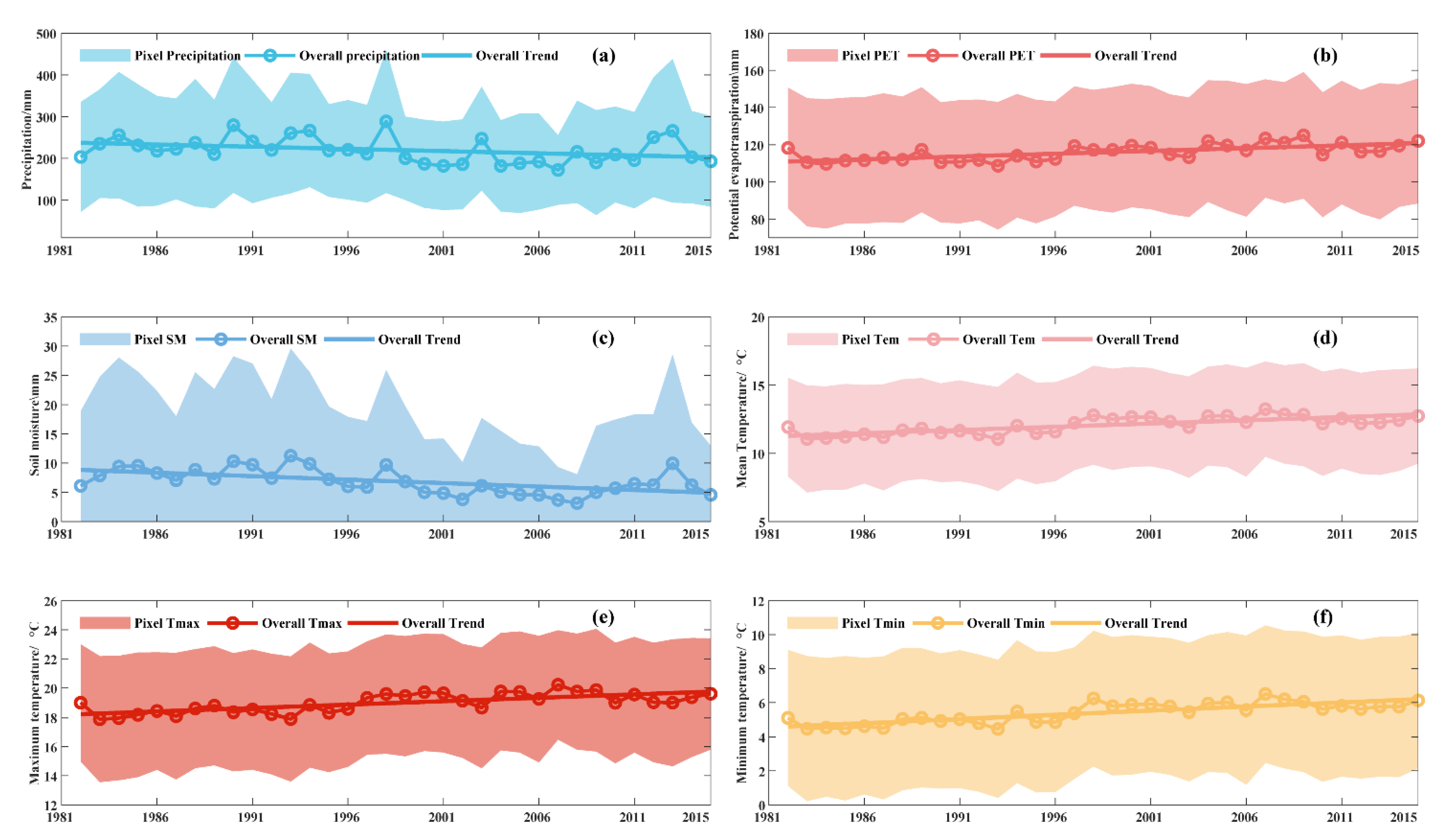
3.1. Long-term Changes in Different Climatic Factors

The trends and slopes in the temporal variation of different climatic factors during the growing season of 1982–2015 in the Mongolian Plateau were detected via the linear regression method (Figure 2). Figure 2 shows that PRE and SM exhibited a statistically significant negative trend in variability of −10.48 and −1.19 mm/decade, respectively (p < 0.05; Figure 2a,c). In line with global warming, an apparent warming trend was evident in the Mongolian Plateau; the mean temperature showed a significant long-term warming trend of 0.47 °C/decade (p < 0.05; Figure 2d). According to the NOAA 2019 Global Climate Summary, the combined land and ocean temperature has increased at an average rate of 0.07 °C per decade since 1880. However, the average rate of temperature increase in the Mongolian plateau has been 0.18 °C per decade since 1981; this is much faster than the average global warming trend [43]. Warming was attributed to an increase in T m i n and T m a x , showing a significant long-term warming trend of 0.47 and 0.48 °C/decade, respectively. This temperature increase implies a significant increase in PET over the long-term (Figure 2b), with a trend of 2.99 mm/decade (p < 0.05).
For the entire region, the multiyear averaged PRE and SM were decreasing from the northeastern to southwestern parts of the Mongolia Plateau, while the spatial distribution of the other four meteorological factors was reversed (Figure S1). The distribution of climatic factors showed a strong spatial gradient (Figure 3). The results show an entire region undergoing a warming trend, in which the average temperature is significant increasing in all pixels. The lower trend values of PET, Tem, Tmax, and Tmin on the southeastern Mongolian Plateau and lower trend values of PRE and SM on the northeastern Mongolian Plateau, which spans 89.56% and 73.79% of pixels, respectively, were all generally decreasing.

3.2. Abrupt Changes in Vegetation Dynamics

Increasingly intense anthropogenic activity and natural variability from climate change will lead to abrupt changes in vegetation. As such, we focused on the detection and characterisation of such changes within the trend component of the monthly NDVI time series for different vegetation and steppe types in the Mongolian Plateau. BFAST was used to identify shifts in monthly NDVI for the different vegetation and steppe types of the Mongolian Plateau (Figure 4). There was a clear fluctuation in the NDVI and an overall increasing trend from 1982 to 2015. The monthly NDVI of desert steppe, scrub, and agricultural vegetation had three BPs, in which the desert steppe experienced a statistically insignificant increase, a significant increase (0.0047 y−1), and an insignificant decrease. The BP years were 1988 and 1994. There was a statistically insignificant decrease at a rate of −0.0001 y−1 in the NDVI for the desert steppe after the BP year. This indicates that the steppes have been degraded by climate change and anthropogenic activity in the last 20 years. Scrub and agricultural vegetation experienced BPs in 2009 and 2015, respectively. These BPs included a statistically significant, insignificant and significant increase, in which the growth rate of NDVI decreased significantly from 1999–2009; this generated an overall increasing trend characterised by a high–low–high pattern. For broadleaf forests, there was no BP, and the overall decreasing slope was almost zero. This indicates that the broadleaf forests of the Mongolian Plateau are relatively stable under the influence of natural and anthropogenic factors. Coniferous forests, meadow steppe, and the typical steppe experienced a BP in 2002, although they all showed an increase in the NDVI before and after the BP. The increase to the NDVI in coniferous forests became smaller after the BP, while the growth rate of meadow steppe changed from being statistically insignificant to significant, in which the rate of change increased from 0.0007 to 0.0023 y−1. The NDVI trend for sand land vegetation increased from 0.0004 to 0.0025 y−1, and alpine steppe experienced a BP in 1993, from a statistically insignificant increase to an insignificant decrease (−0.0005 y−1). Overall, the changes to the NDVI showed significant spatial heterogeneity for different vegetation types in the region due to the spatial variability in anthropogenic activity and climatic factors.
Spatial variability ceases when we focus on the subregion, due to the diversity of vegetation types over the Mongolian Plateau. As such, we also counted the numbers of BFAST detected BPs for the proportion of total and specific land cover areas (%) for different vegetation and steppe types between 1982 and 2015; the statistical results are detailed in Table 2 and Table 3. The results show that the number of abrupt trend-shifts that were detected varied from zero to four at the pixel scale. In total, the area fraction of BPs made up 69.58% of the entire Mongolian Plateau, while 39.95% of pixels had one BP that accounted for 57.42% of the total number of BPs. The typical and desert steppes with one or more BPs accounted for 29.38% and 13.82% of the Mongolian Plateau, while 74.9% and 70.34% of both vegetation types had one or more BPs, respectively. In particular, 30.41% of desert steppe had two BPs, while 12.27% of desert steppe pixels had three BPs; these results indicate that desert steppe has been affected by significant anthropogenic activity or climate change. For the shrub vegetation type, the BFAST detected BPs accounted for 2.16% of this type. However, 79.47% of the shrub pixels had one or more BPs; this was the highest percentage of all the vegetation and steppe types. This means that the shrub type has also been affected by significant anthropogenic activity or environmental conditions. For alpine steppe, broadleaf, and coniferous forests, the proportion of BPs was small for the overall population; however, each of these types have experienced a relatively lower intensity impact from climate change and anthropogenic activity than other areas.
For the entire region, the multiyear averaged NDVIgs was decreasing from the northeastern to southwestern Mongolia Plateau; this is consistent with the distribution of climatic factors and terrestrial characteristics. The spatial distribution of the variations in NDVIgs for 1982–2015 as per the linear regression method is shown in Figure S2b,c. The results show that 71.16% of pixels experienced an increase in the NDVIgs, particularly in eastern Mongolia and the southern border of IMG. The statistical results show that 37.67% of pixels showed significant growth, with only 7.15% of the pixels exhibiting a significant decrease. Vegetation changes on the Mongolian Plateau were impacted by the compounding effects of human activity and climatic factors, such as wildfire and grazing [44,45]. The BFAST method provides functionality to detect stable yet abnormal changes from historical trends in the monthly NDVI. The results show that the years experiencing abrupt changes were distributed from 1987 to 2010, with a total of 40 989 BPs. Overall, the NDVI on the Mongolian Plateau initially experienced widespread abrupt changes in 1993, accounting for 8.70% of the total number of one or more BP pixels; these abrupt changes also occurred in 2002 and 2003. Many areas experiencing abrupt changes were identified in Mongolia, accounting for 6.70% and 8.85% of the total number of pixels, respectively. There were also many areas experiencing abrupt changes in NDVI every year until 2010, where they reached a peak of 9.63%. Further analysis revealed that most areas experiencing abrupt changes in 1993 were found in Mongolia, followed by those in 2010 (2794 pixels). In contrast, IMG had the highest percentage of abrupt changes in 2003, followed by 2006 and 2007. Overall, 1993, 2003, and 2010 were the years predominantly experiencing abrupt changes.
The spatial distribution of trend changes before and after BPs for 1982–2015 on the Mongolian Plateau is shown in Figure 5. BFAST detected trend variations with no BPs accounted for 30.42% of pixels; these areas were mainly located in the middle (Xilin Gol grassland) and northeastern (Hulunbuir grassland) IMG, China, and northwestern Mongolia (Figure 5a). These areas were mainly comprised of typical steppe, desert steppe, and coniferous forests. Figure 5b,c show the spatio-temporal distribution and variations of NDVI before and after one BP, respectively. There were 16 variations, and the “increased significantly-increased significantly” variation reached up to 26.93% of the total number. Following the BP, 71.34% of pixels showed an increasing trend, in which this trend was statistically significant for 77.74% of those pixels. The mean variation of NDVI changed from 4.450 × 10⁻⁴ to 2.708 × 10⁻³ y−1; the variation after the BP was approximately six times greater than before the BP. This means that after the changepoint years, the vegetation in northeastern Mongolia and east of central IMG is improving. This may be partially attributable to the positive efficacy of the Three-North Shelter Forest Program [46]. Figure 5d–f shows that of the BFAST detected trend variations with two BPs or more, the majority were located in Mongolia, including 85.26% and 95.55% of pixels with three and four BPs, respectively. In particular, northwestern Mongolia showed a northwest-southeast oriented strip, indicating that vegetation has been significantly affected at different times in this region, resulting in frequent variations in vegetation.

3.3. Vegetation Responses to Climate Change

3.3.1. Vegetation Responses to Interannual Climate Change during the Growing Season

Figure 6 quantifies of the partial correlation coefficients between climatic factors and NDVIgs from 1982 to 2015. These coefficients offer a better understanding on the magnitude of influence on NDVI from changes in meteorological factors during the growing season. The results show that the partial correlations between mean NDVIgs and PRE signified a spatially reversed relationship with other factors, with 75.01% of pixels (37.49% of pixels were statistically significant) that were positively correlated with mean NDVIgs. This was mainly distributed in the central part of the Mongolian Plateau, while the coniferous forest and broadleaf forests in north-central Mongolia and eastern IMG were negatively correlated (Figure 6a). This is consistent with the results of Guo et al. [47] who reported a negative correlation between the corresponding PRE and NDVIgs in relatively colder regions. This was also partly confirmed by Fang et al. [48], who found that forest growth tended to decrease with increasing PRE under relatively cold conditions. Positive correlations between PRE and NDVIgs were also found in the desert steppe (97.76% of pixels; 68.47% statistically significant), sand land vegetation (94.44% of pixels; 41.96% statistically significant), and the typical steppe (93.84% of pixels; 65.35% statistically significant). PET and mean NDVIgs were negatively correlated in the western part of Mongolia and central IMG, accounting for 55.97% of pixels (Figure 6b). PRE and mean NDVIgs were positively correlated; however, there was a negative correlation with PET during the growing season. This means that PRE was the primary factor for vegetation growth, while PET was the competing factor, generally reducing water availability [49]. Regions of high latitude and those in the southwest showed negative correlations, which may be related to higher temperatures accelerating snow melt [50] and increased PRE in the southwestern region. SM was the dominant driver of dry stress across ecosystem production [51]. We found that this factor accounted for 43.39% of pixels in which a negative correlation was observed (Figure 6c). This was particularly the case for the coniferous (64.93%) and broadleaf forests (56.96%), which may be related to the high-water demand of vegetation [52]. Figure 6d shows that there were 59.16% pixels with a positive correlation between Tem and mean NDVIgs, as per partial correlation analysis. This was particularly the case for coniferous (81.92%) and broadleaf forests (63.54%). This signifies the occurrence of amplified vegetation growth due to a faster warming rate than the warming rate at low latitudes. The mean NDVIgs increased in 70.74% of the sand land vegetation, which along with 94.44% pixels of PRE, showed an increasing trend. This conclusion is consistent with the relatively closer relationship between the temperate desert steppe and PRE than temperature [49]. Additionally, the optimal combination of water and heat conditions increased vegetation growth, while 53.29% and 63.96% of Tmax and Tmin pixels, respectively, were positively correlation with mean NDVIgs, and demonstrated spatial consistency in Figure 6d. This illustrates that the decrease in diurnal temperature difference had a clear positive effect on vegetation growth.
The spatial heterogeneity of correlation between climatic factors and NDVIgs represents a general characteristic. Figure 7 presents the variation in the annual NDVIgs with the aridity index (AI) in order to investigate the heterogeneity of NDVI with gradient change at spatial scale. The AI is a simple and convenient numerical indicator of aridity based on long-term climatic water deficits; it is equal to the PRE/PET ratio. We calculated the annual mean AI and determined the aridity conditions of the region based on four pre-determined climatic categories: arid (0 < AI < 0.2); subhumid (0.2 ≤ AI < 0.5); semiarid (0.5 ≤ AI < 0.65), and humid (AI ≥ 0.65). The results show that dry conditions significantly affect vegetation dynamics; the wetter the conditions, the better vegetation growth. As such, the highest NDVI values were mainly located in the subhumid zone (Figure 7b). However, the annual NDVIgs of the vegetation and steppe types showed homologous oscillations in three of the climatic categories. The lowest oscillations for the NDVIgs occurred in the subhumid zone, ranging from 0.40 to 0.70. The NDVIgs of the semiarid zone ranged from 0.00 to 0.78, and demonstrated the highest degree of oscillation; as such, except for vegetation itself, dry and wet conditions, also led to the oscillation of NDVI.
The geographical detector model was applied to clarify any correlations between climatic factors and mean NDVI (including non-linear relationship) during the growing season of 1982–2015 from a spatial heterogeneity perspective. Figure 8a shows the rank contributions of climatic factors on the NDVIgs using the factor detector; the PRE had the highest Q value compared with the other climatic factors This which means that PRE is the most important climatic factor, while the second most important variable was SM. The remaining four climatic factors were far less important for NDVI than PRE and SM. The interaction detector was used to compare the sum contribution of two individual climatic factors, with the contribution of two attributes when combined together (Figure 8b). The results showed that the interaction between variables demonstrate a bi-variable enhancement pattern, without uni-variable weakening, independent or nonlinear-enhancement conditions; this means that bi-variable enhancement occurred from the interaction. The interaction between PRE and TEM had the highest combined Q value (0.8921). This interaction was the major interactive variables affecting vegetation change in the study area, followed by Tmax (Q = 0.8874) and Tmin (Q = 0.8844). The Q values of SM and PET, SM and TEM, SM and Tmax, and PRE and SM, exceeded 0.8. We observed robust drier–hotter conditions under strengthened soil moisture–temperature coupling over Mongolia and northern China [53]; the results from the geographical detector were also consistent with this observation.

3.3.2. Spatial Patterns of the Cumulative Effects of Climate Change on NDVI

Vegetation is affected by the SM deficit and hydrothermal conditions during the growing season. As such, the soil water content is related to climatic variations throughout the month, and the degree of influence from early climatic changes on SM, such as high PRE and low PET conditions. This may cause the soil to remain wet over a long period of time, which may ultimately be beneficial to vegetation growth [54]. This indicates that the NDVI usually experiences stronger cumulative effects from climate change. To investigate the response of vegetation to cumulative climate change, we focused on how the effects of long-term climate change were most likely to control vegetation growth. We and screened out the preceding months when meteorological drivers were likely to have a larger influence on vegetation. Based on the partial correlation analysis method, the cumulative effects of climatic factors on NDVIgs was estimated using the month with the largest correlation coefficient ( R a c c m a x - g s ). Figure 9 presents the results, demonstrating that 99.75% of pixels occur when a large number of rainfall events promote vegetation growth. This includes 75.67% of pixels exhibiting a significant growth promotion (at a significance level of 95%, as shown in Figure 9b). Most of R a c c m a x - g s time is concentrated in 1–6 months, particularly in January (13.54% of pixels at a significance level of 95%), April (22.06% of pixels at a significance level of 95%), and May (20.87% of pixels at a significance level of 95%). This means that the amount of PRE in early spring may affect the greening-up of vegetation, and the amount of snowfall in winter affects SM. In turn, this impacts on vegetation growth, whereby pixels affected over a long period of time were mainly concentrate in the high latitude regions. The R a c c m a x - g s for PET was positively correlated with NDVIgs up to 79%, with a spatial distribution similar to that shown in Figure 8b. Regions of high latitude were dominated by one month of cumulative effects, while other regions experienced these effects between seven and nine months (the start of the growing season to the early summer of the previous year), and six months (early autumn to the end of the growing season of the following year). During those six months, which accounted for 23.22% of the total pixels, the R a c c m a x - g s for SM was positively correlated with NDVIgs up to 77.45%, including 19.25% of pixels at a significance level of 95%. The one-month-period was the period of time in which the highest percentage of cumulative effects (25.54%) occurred, followed by three months (12.97%); this was particularly the case for the typical and desert steppes. The R a c c m a x - g s of the three temperature variables exhibited relatively consistent spatial characteristics. For Tem, Tmax, and Tmin, the proportion of pixels that were positively correlated to NDVIgs was 77.45%, 70.40%, and 75.12%, respectively. Higher temperatures over one or two months promotes vegetation growth, which may be related to an earlier onset of greening-up for vegetation. This earlier onset results in a longer phenological period, particularly for vegetation in the high latitudes [55].

3.4. Vegetation Responses to Anthropogenic Factors

Meteorological factors are important drivers of vegetation change, particularly in steppes, where the influence of climate on steppe vegetation is often magnified. However, with rapid urbanisation and industrialisation, anthropogenic activities have become one of the driving factors for climate change, becoming hugely influential on observed climate variations [56]. In this research, the RESTREND method was used to separate the effects of meteorological factors and anthropogenic activity on vegetation change, where ecosystem responsiveness to anthropogenic activity was measured by the residual ε . A positive ε indicates that anthropogenic activity promotes vegetation growth, while a negative ε is indicative of a negative effect on vegetation growth. The results show that the residual values showed a positive trend for 81.21% of the study area, in which 19.87% of the pixels showed a significant trend. This mainly occurred in the northeastern part of Mongolia and the bordering areas with China, although it was also sporadic in other areas, including the eastern Xing’an League, and the southern Chifeng and Hohhot, China. This demonstrates that anthropogenic influence dominates vegetation variations on the Mongolian Plateau (Figure 10). Areas with a negative trend of residual values showed strong consistency with the urban and rural distribution, indicating that the vegetation near settlements was more severely negatively disturbed by anthropogenic activity such as urban expansion and road construction during rapid economic development and population growth. The Chinese and Mongolian governments have implemented efforts towards increased environmental protection and ecological restoration [57]. These efforts have stabilised the land degradation that was occurring in the Mongolian Plateau. For example, over 19000 ha of degraded forest has been restored and successfully reforested between 1971 and 2011 [58]. In particular, Dornod, Khentii, and Sukhbaatar of Mongolia are a testament that anthropogenic activities substantially contribute to increasing NDVI. This may be related to the development of the Kherlen River basin and the restored management of mining areas [59,60]. Overall, anthropogenic activity was observed to have a strong impact on vegetation growth on the Mongolian Plateau.

3.5. Vegetation Responses to the Combined Effects of Climate Change and Anthropogenic Factors

It is difficult to disentangle the effects of climate change from those of anthropogenic factors on the NDVI, as they are strongly coupled through human-and interactions. To detect vegetation responses to climate change and anthropogenic factors, we compared their relative importance for the NDVIgs on the Mongolian Plateau with those at the national level (as shown in Figure 11). The results show that all climatic factors contributions to NDVI changes exceeded 50% at the Mongolian Plateau, demonstrating that the Mongolian Plateau is mainly influenced by meteorological factors, which is consistent with previous results. The exception to this result was the cumulative contribution of meteoro-logical factors to changes in NDVI as quantified using the first method, which was 49.35% [20,61]. In addition, the dominant anthropogenic factors influencing NDVI changes were mainly the economic activity and population growth. The contribution of GDP to NDVI obtained by the four methods was between 20.74% and 29.30%. The dominant meteorological factors were mainly PRE and SM, in which the contribution of PRE to NDVI fell between 17.69% and 30.60%, and SM fell between 13.32% and 20.02%. The other contributions were less than 10%, indicating that PRE was the most important factor influencing vegetation growth. For Mongolia and the IMG Autonomous Region of China, the factors that governed vegetation change varied in terms of their level of influence due to differences in systems and economic structures; among all factors, the GDP, PRE, and SM were ranked in the top three. This indicates that rapid economic growth within the IMG is the main anthropogenic factor affecting vegetation variation. In Mongolia, the PRE (with a relative importance ranging from 22.12% to 31.19%), was the main climatic factor affecting vegetation change, while population (with a contribution rate between 13.67% and 32.08%) and livestock were the main anthropogenic factors.

4. Discussion

The shifts and dynamics of the different vegetation types may also be induced by anthropogenic perturbations as well as being related to the BP of natural factors. These activities include grazing, afforestation, policy-driven land use conversions, ecological restoration, mining, and urban expansion. The turning point of vegetation change may be divided into several types, such as statistically insignificant and significant increases. The Chinese and Mongolian governments differ in terms of institutional and socioeconomic trajectories, and these differences have magnified over the past century. In the IMG, particularly in the central region, persistent overgrazing has exceeded the capacity of the available pastureland. As such, in the 1990s the local and central governments implemented a grazing exclusion policy including the Three-North Shelter Forest Program (TNSFP), the Grain to Green Program (GGP), and the Natural Forest Protection Program (NFPP). Fenced grassland patches were established to exclude grazing activity; these management actions may promote green ecosystem practices and conditions in the IMG [62,63]. In addition, increasing land degradation led to a series of legislative controls to minimise land degradation in Mongolia; these includes the Issue Mongolia Land Law, the Law of Land Privatisation for Mongolian citizens in 2002, and nationally appropriate mitigation action (NAMA) for steppe and livestock management in 2010 [64].The transfer matrix of land cover demonstrates that shrubland and tree cover were largely driven by bare areas, in which 19575.36 and 10607.49 km2 of land were transferred from bare areas for 1992–2015, respectively. Further analysis of this transfer matrix of land cover from 1993–2003, shows that 11094.12 km2 of land was transferred to bare areas. These results (Figure 12b), show that China and Mongolia have strengthened their efforts to control desertification in which during 2003–2010, 8304.93 and 6395.04 km2 of land has been transferred to shrubland and tree cover from bare areas, respectively (Figure 12c). Almost all livestock in Mongolia is now privately owned by rural residents since the collapse of the Soviet Union. Since 1993, herders have raised many farm animals to increase their income. Between 1999 and 2002, snow and drought disasters frequently occur in the Mongolian Plateau, and an unusual heavy snow disaster occurred in Mongolia in 2010, leading to a dramatic decline in the number of livestock within this period [65]. The results show that the change point of livestock is highly consistent with the change point of NDVI (Figure 12a). In terms of the population and GDP of Mongolia and the IMG, there is a significant growth trend (Figure 13b,c). Currently, the population of Mongolia is mainly migrating to Ulaanbaatar; as such there has been a dramatic increase in the urban population [66]. These institutional arrangements have improved vegetation restoration on the Mongolian Plateau.
This study shows that vegetation has experienced a greening trend over the entire Mongolian Plateau, consistent with recent findings [67]. The literature on the Mongolian Plateau has reported on the contributions of climatic drivers to vegetation dynamics [16,18,23,26]. The rate of temperature increase on the Mongolia Plateau was faster than that of global warming, which may enhance vegetation activity and lengthen the growing season. This study observed a strong relationship between the NDVI and PRE in the agricultural vegetation and steppes of the Mongolian Plateau, while PRE had a lower impact than that of temperature in forests. This may be because agricultural vegetation and steppes are more sensitive to PRE than forests. The PET was found to generally reduce water availability and limit SM, particularly in high-latitude regions. We observed a prolonged PRE before the growing season and a short-medium term warming phenomena promoted vegetation growth, as did SM. The high latitude regions were dominated by longer periods in which the cumulative effects of PRE and SM were apparent. Moreover, the increased frequency and intensity of extreme weather events, such as droughts, are likely to cause major changes in vegetation cover. Unprecedented heatwave-drought concurrences over inner East Asia have been reported in the past two decades, impacting vegetation cover through changes such as increased tree mortality, particularly in Mongolia and Northern China [53].
It is important to emphasise that these are preliminary findings on vegetation responses and the driving climatic and anthropogenic factors, in which several relevant questions remain unanswered. The low spatial resolution (8 km) of the GIMMS NDVI3g data used in this research may eliminate phenological characteristics, or some normal ecological success of vegetation. In future, the use of the Google Earth platform may improve the certainty of further research as the Landsat and Sentinel datasets, open-source change detection algorithms and powerful computer servers are more easily accessible. Combining this theoretical analysis with ground observation data, may enable further analysis of the temporal variability of living biomass orLeaf Area Index (LAI) using NDVI as an intermediate characteristic. For example, estimating biomass using LAI or NDVI derived from Landsat 8 and Sentinel-2 data. This study used reanalysis data for the climatic factors and three indicators to characterise the impact of anthropogenic activity on vegetation. There are many other anthropogenic indicators that were not considered in the study, which may result in greater uncertainty in the accuracy of result while allowing for a more complete analysis. However, the analysis presented here is considered useful as it provides a flexible method to aggregate existing knowledge on long-term vegetation dynamics and the driving climatic and anthropogenic factors. Such a method will aid in the implementation of mitigation and planning measures to improve vegetation condition in the Mongolian Plateau.

5. Conclusions

After exploring the climatic and vegetation change characteristics, this study offers an improved understanding of the effect of climatic and anthropogenic factors on NDVI on the Mongolian Plateau for the 1982–2015 period. We attempted to differentiate between anthropogenic-induced and climate-driven vegetation dynamics. The detailed conclusions are as follows:
  • For the entire Mongolian Plateau, there was a statistically significant increase in the PRE and SM at a rate of −10.48 and −1.19 mm/decade during the growing season, respectively. The mean temperature was observed to increase at a greater rate than that of worldwide global warming, resulting in a significant increase in PET at a rate of 2.99 mm/decade. The Tem of all pixels showed a significant increasing trend, while the PRE in 89.56 % of the study area showed a decreasing trend.
  • There was significant spatial heterogeneity in changes to the NDVI for various vegetation types in the Mongolian Plateau. We found a fluctuation in the NDVI and an overall increasing trend from 1982–2015, with the except for broadleaf forests.
  • At the pixel scale, BFAST detected trend variations showed that the total number of one or more BPs accounted for 71.34% of pixels, and 1993, 2003, and 2010 were the predominant years in which abrupt NDVI changes occurred on the Mongolian Plateau.
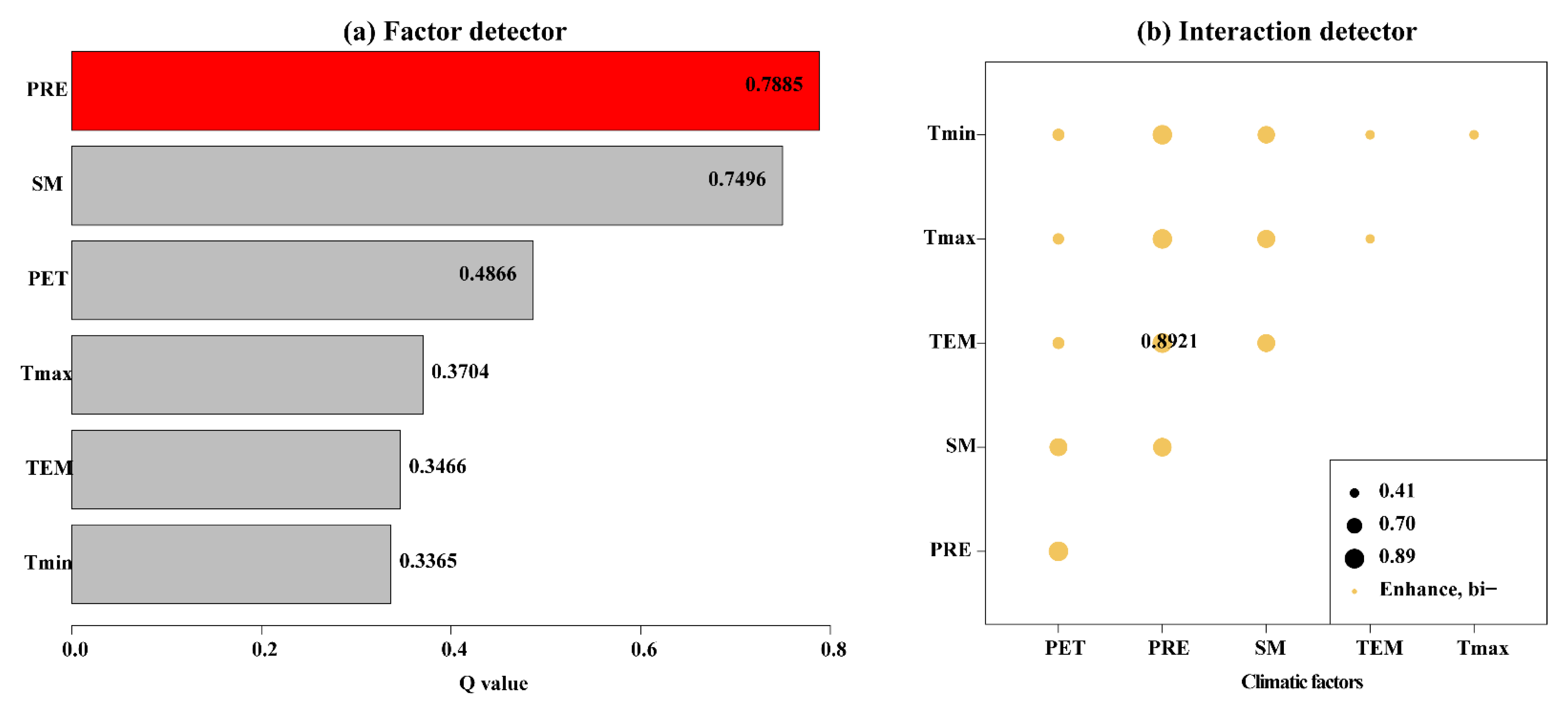
  • All six climate factors (PRE, PET, SM, Tem, Tmax, and Tmin) had a significant influence on interannual NDVIgs variations, with large spatio-temporal heterogeneities. The interaction between climatic factors followed a bi-variable enhancement pattern. Moreover, PRE was the main climatic factor that positively influenced change in NDVIgs, accounting for 75.01% of the region, while the dominant mean NDVIgs change pattern was negatively correlated with PET, accounting for 55.97% of the area. The cumulative effects of climatic factors varied in terms of their influence on vegetation change.
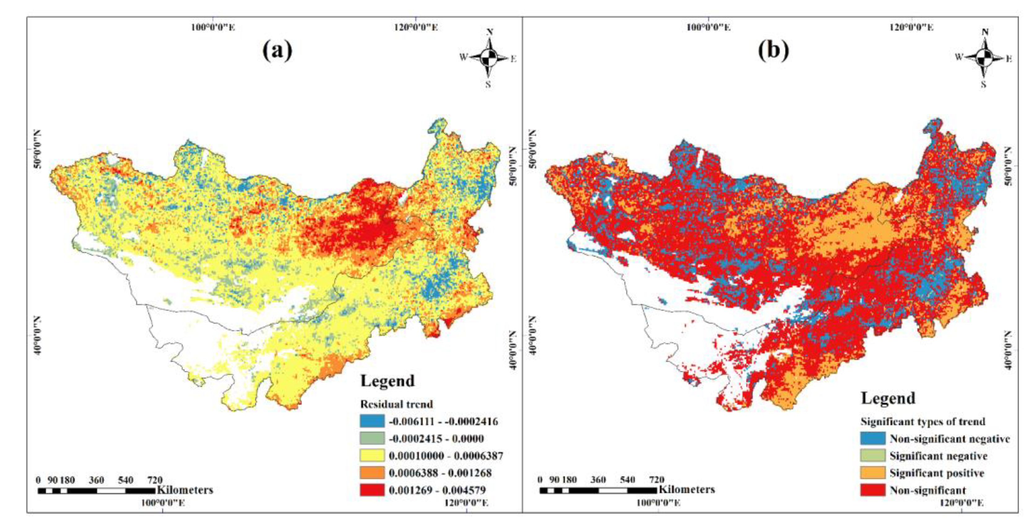
  • The results of the RESTREND method showed that 81.21% of the vegetation was positively influenced by anthropogenic activity on the Mongolian Plateau. However, there were multiple driving factors for vegetation changes in different regions. Specifically, the rapid economic growth (GDP), PRE, and SM were the key factors in IMG, while in Mongolia, PRE was the main climatic factor, while population and livestock were the key anthropogenic factors.

Supplementary Materials

The following are available online at https://www.mdpi.com/2072-4292/13/4/688/s1, Figure S1: Spatial distribution of multi-year average climate factors during growing season of 1982-2015 in Mongolia Plateau. (a) PRE, (b) PET, (c) SM, (d) Tem, (e) Tmax, (f) Tmin. Figure S2: Spatial distribution of multi-year average (a), change trend (b) and the significant levels (c) of NDVI during growing season from 1982 to 2015 in Mongolia Plateau.

Author Contributions

E.G., conceptualization, methodology, writing—original draft; Y.W., conceptualization, supervision; C.W., writing—review and editing; Z.S., software; Y.B. (Yulong Bao), visualization; N.M., investigation; B.J., investigation; Y.B. (Yuhai Bao), investigation; H.L., validation. All authors have read and agreed to the published version of the manuscript.

Funding

The project was supported by the Natural Science Foundation of Inner Mongolia Autonomous Region of China (2020LH04003), the National Natural Science Foundation of China (41807507 and 41801353), the Drought Meteorology Science Research Program (IAM201904). High-level introduction of talent research start-up fund in Inner Mongolia Normal University (2018YJRC008 and 2019YJRC003). The Key Program of National Natural Science Foundation of China (61631011). Science and technology planning project in Inner Mongolia (201702116).

Institutional Review Board Statement

Not applicable.

Informed Consent Statement

Not applicable.

Data Availability Statement

Not applicable.

Acknowledgments

The authors would like to thank the Editors and the anonymous reviewers for their crucial comments, which improved the quality of this paper.

Conflicts of Interest

The authors declare no conflict of interest.

References

  1. Piedallu, C.; Cheret, V.; Denux, J.P.; Perez, V.; Azcona, J.S.; Seynave, I.; Gegout, J.C. Soil and climate differently impact NDVI patterns according to the season and the stand type. Sci. Total Environ. 2019, 651, 2874–2885. [Google Scholar] [CrossRef]
  2. Cao, R.; Chen, Y.; Shen, M.; Chen, J.; Zhou, J.; Wang, C.; Yang, W. A simple method to improve the quality of NDVI time-series data by integrating spatiotemporal information with the Savitzky-Golay filter. Remote Sens. Environ. 2018, 217, 244–257. [Google Scholar] [CrossRef]
  3. Fang, H.; Baret, F.; Plummer, S.; Schaepman Strub, G. An Overview of Global Leaf Area Index (LAI): Methods, Products, Validation, and Applications. Rev. Geophys. 2019, 57, 739–799. [Google Scholar] [CrossRef]
  4. Zhang, Z.; Zhang, Y.; Zhang, Y.; Gobron, N.; Frankenberg, C.; Wang, S.; Li, Z. The potential of satellite FPAR product for GPP estimation: An indirect evaluation using solar-induced chlorophyll fluorescence. Remote Sens. Environ. 2020, 240, 111686. [Google Scholar] [CrossRef]
  5. Zewdie, W.; Csaplovics, E.; Inostroza, L. Monitoring ecosystem dynamics in northwestern Ethiopia using NDVI and climate variables to assess long term trends in dryland vegetation variability. Appl. Geogr. 2017, 79, 167–178. [Google Scholar] [CrossRef]
  6. Ye, W.T.; van Dijk, A.I.J.M.; Huete, A.; Yebra, M. Global trends in vegetation seasonality in the GIMMS NDVI3g and their robustness. Int. J. Appl. Earth Obs. Geoinf. 2021, 94, 102238. [Google Scholar] [CrossRef]
  7. Sun, R.; Chen, S.H.; Su, H.B. Climate Dynamics of the Spatiotemporal Changes of Vegetation NDVI in Northern China from 1982 to 2015. Remote Sens. 2021, 13, 187. [Google Scholar] [CrossRef]
  8. Li, J.; Fan, K.; Xu, J.; Powell, A.M.; Kogan, F. The effect of preceding wintertime Arctic polar vortex on springtime NDVI patterns in boreal Eurasia, 1982–2015. Clim. Dyn. 2017, 49, 23–35. [Google Scholar] [CrossRef]
  9. Chen, T.; de Jeu, R.A.M.; Liu, Y.Y.; van der Werf, G.R.; Dolman, A.J. Using satellite based soil moisture to quantify the water driven variability in NDVI: A case study over mainland Australia. Remote Sens. Environ. 2014, 140, 330–338. [Google Scholar] [CrossRef]
  10. Jamali, S.; Seaquist, J.; Eklundh, L.; Ardö, J. Automated mapping of vegetation trends with polynomials using NDVI imagery over the Sahel. Remote Sens. Environ. 2014, 141, 79–89. [Google Scholar] [CrossRef]
  11. Xu, X.; Liu, H.; Lin, Z.; Jiao, F.; Gong, H. Relationship of Abrupt Vegetation Change to Climate Change and Ecological Engineering with Multi-Timescale Analysis in the Karst Region, Southwest China. Remote Sens. 2019, 11, 1564. [Google Scholar] [CrossRef] [Green Version]
  12. Militino, A.F.; Moradi, M.; Ugarte, M.D. On the Performances of Trend and Change-Point Detection Methods for Remote Sensing Data. Remote Sens. 2020, 12, 1008. [Google Scholar] [CrossRef] [Green Version]
  13. Zhang, P.P.; Cai, Y.P.; Yang, W.; Yi, Y.Y.; Yang, Z.F.; Fu, Q. Contributions of climatic and anthropogenic drivers to vegetation dynamics indicated by NDVI in a large dam-reservoir-river system. J. Cleaner Prod. 2020, 256, 120477. [Google Scholar] [CrossRef]
  14. Wen, Z.F.; Wu, S.J.; Chen, J.L.; Lü, M.Q. NDVI indicated long-term interannual changes in vegetation activities and their responses to climatic and anthropogenic factors in the Three Gorges Reservoir Region, China. Sci. Total Environ. 2017, 574, 947–959. [Google Scholar] [CrossRef]
  15. Han, D.; Gao, C.; Liu, H.; Yu, X.; Li, Y.; Cong, J.; Wang, G. Vegetation dynamics and its response to climate change during the past 2000 years along the Amur River Basin, Northeast China. Ecol. Indic. 2020, 117, 106577. [Google Scholar] [CrossRef]
  16. Kern, A.; Marjanović, H.; Barcza, Z. Spring vegetation green-up dynamics in Central Europe based on 20-year long MODIS NDVI data. Agr. Forest Meteorol. 2020, 287, 107969. [Google Scholar] [CrossRef]
  17. Linscheid, N.; Estupinan-Suarez, L.M.; Brenning, A.; Carvalhais, N.; Cremer, F.; Gans, F.; Rammig, A.; Reichstein, M.; Sierra, C.A.; Mahecha, M.D. Towards a global understanding of vegetation–climate dynamics at multiple timescales. Biogeosciences 2020, 17, 945–962. [Google Scholar] [CrossRef]
  18. Peng, W.; Kuang, T.; Tao, S. Quantifying influences of natural factors on vegetation NDVI changes based on geographical detector in Sichuan, western China. J. Clean. Prod. 2019, 233, 353–367. [Google Scholar] [CrossRef]
  19. Zhou, X.; Yamaguchi, Y.; Arjasakusuma, S. Distinguishing the vegetation dynamics induced by anthropogenic factors using vegetation optical depth and AVHRR NDVI: A cross-border study on the Mongolian Plateau. Sci. Total Environ. 2018, 616, 730–743. [Google Scholar] [CrossRef]
  20. Gang, C.; Wei, Z.; Chen, Y.; Wang, Z.; Sun, Z.; Li, J.; Qi, J.; Odeh, I. Quantitative assessment of the contributions of climate change and human activities on global grassland degradation. Environ. Earth Sci. 2014, 72, 4273–4282. [Google Scholar] [CrossRef]
  21. Zhang, Y.; Wang, Q.; Wang, Z.; Yang, Y.; Li, J. Impact of human activities and climate change on the grassland dynamics under different regime policies in the Mongolian Plateau. Sci. Total Environ. 2020, 698, 134304. [Google Scholar] [CrossRef]
  22. Fan, D.; Ni, L.; Jiang, X.; Fang, S.; Wu, H.; Zhang, X. Spatiotemporal Analysis of Vegetation Changes along the Belt and Road Initiative Region from 1982 to 2015. IEEE Access 2020, 8, 122579–122588. [Google Scholar] [CrossRef]
  23. Ying, H.; Zhang, H.; Zhao, J.; Shan, Y.; Zhang, Z.; Guo, X.; Rihan, W.; Deng, G. Effects of spring and summer extreme climate events on the autumn phenology of different vegetation types of Inner Mongolia, China, from 1982 to 2015. Ecolo. Indic. 2020, 111, 105974. [Google Scholar] [CrossRef]
  24. Bao, G.; Chen, J.; Chopping, M.; Bao, Y.; Bayarsaikhan, S.; Dorjsuren, A.; Tuya, A.; Jirigala, B.; Qin, Z. Dynamics of net primary productivity on the Mongolian Plateau: Joint regulations of phenology and drought. Int. J. Appl. Earth Obs. 2019, 81, 85–97. [Google Scholar] [CrossRef]
  25. Jin, H.; Bao, G.; Chen, J.; Chopping, M.; Jin, E.; Mandakh, U.; Jiang, K.; Huang, X.; Bao, Y.; Vandansambuu, B. Modifying the maximal light-use efficiency for enhancing predictions of vegetation net primary productivity on the Mongolian Plateau. Int. J. Remote Sens. 2019, 41, 3740–3760. [Google Scholar] [CrossRef]
  26. Bao, G.; Bao, Y.; Sanjjava, A.; Qin, Z.; Zhou, Y.; Xu, G. NDVI-indicated long-term vegetation dynamics in Mongolia and their response to climate change at biome scale. Int. J. Climatol. 2015, 35, 4293–4306. [Google Scholar] [CrossRef]
  27. Rogers, A.; Medlyn, B.E.; Dukes, J.S. A roadmap for improving the representation of photosynthesis in Earth system models. New Phytol. 2017, 213, 22–42. [Google Scholar] [CrossRef] [PubMed] [Green Version]
  28. Kottek, M.; Grieser, J.; Beck, C.; Rudolf, B.; Rubel, F. World map of the Köppen-Geiger climate classification updated. Meteorol. Z. 2006, 15, 259–263. [Google Scholar] [CrossRef]
  29. Dong, G.; Zhao, F.Y.; Chen, J.Y.; Zhang, Y.; Qu, L.P.; Jiang, S.C.; Ochirbat, B.; Chen, J.Y.; Xin, X.P.; Shao, C.L. Non-climatic component provoked substantial spatiotemporal changes of carbon and water use efficiency on the Mongolian Plateau. Environ. Res. Lett. 2020, 15, 095009. [Google Scholar] [CrossRef]
  30. Tong, S.; Zhang, J.; Ha, S.; Lai, Q.; Ma, Q. Dynamics of Fractional Vegetation Coverage and Its Relationship with Climate and Human Activities in Inner Mongolia, China. Remote Sens. 2016, 8, 776. [Google Scholar] [CrossRef] [Green Version]
  31. Bao, G.; Bao, Y.; Qin, Z.; Xin, X.; Bao, Y.; Bayarsaikan, S.; Zhou, Y.; Chuntai, B. Modeling net primary productivity of terrestrial ecosystems in the semi-arid climate of the Mongolian Plateau using LSWI-based CASA ecosystem model. Int. J. Appl. Earth Obs. 2016, 46, 84–93. [Google Scholar] [CrossRef]
  32. Pinzon, J.E. A Non-Stationary 1981-2015 AVHRR NDVI 3g Time Series. In Proceedings of the AGU Fall Meeting, San Francisco, CA, USA, 14–18 December 2015. [Google Scholar]
  33. Abatzoglou, J.T.; Dobrowski, S.Z.; Parks, S.A.; Hegewisch, K.C. TerraClimate, a high-resolution global dataset of monthly climate and climatic water balance from 1958–2015. Sci. Data 2018, 5, 170191. [Google Scholar] [CrossRef] [PubMed] [Green Version]
  34. Liu, Z.; Wu, C.; Liu, Y.; Wang, X.; Fang, B.; Yuan, W.; Ge, Q. Spring green-up date derived from GIMMS3g and SPOT-VGT NDVI of winter wheat cropland in the North China Plain. ISPRS J. Photogramm. 2017, 130, 81–91. [Google Scholar] [CrossRef]
  35. Verbesselt, J.; Hyndman, R.; Newnham, G.; Culvenor, D. Detecting trend and seasonal changes in satellite image time series. Remote Sens. Environ. 2010, 114, 106–115. [Google Scholar] [CrossRef]
  36. Wang, Y.; Liu, G.; Guo, E. Spatial distribution and temporal variation of drought in Inner Mongolia during 1901–2014 using Standardized Precipitation Evapotranspiration Index. Sci. Total Environ. 2019, 654, 850–862. [Google Scholar] [CrossRef]
  37. Song, Y.Z.; Wang, J.F.; Ge, Y.; Xu, C.D. An optimal parameters-based geographical detector model enhances geographic characteristics of explanatory variables for spatial heterogeneity analysis: Cases with different types of spatial data. Gisci. Remote Sens. 2020, 57, 593–610. [Google Scholar] [CrossRef]
  38. Wang, J.F.; Li, X.H.; Christakos, G.; Liao, Y.L.; Zhang, T.; Gu, X.; Zheng, X.Y. Geographical Detectors-Based Health Risk Assessment and its Application in the Neural Tube Defects Study of the Heshun Region, China. Int. J. Geogr. Inf. Sci 2010, 24, 107–127. [Google Scholar] [CrossRef]
  39. Evans, J.; Geerken, R. Discrimination between climate and human-induced dryland degradation. J. Arid Environ. 2014, 57, 535–554. [Google Scholar] [CrossRef]
  40. Chu, H.; Venevsky, S.; Wu, C.; Wang, M. NDVI-based vegetation dynamics and its response to climate changes at Amur-Heilongjiang River Basin from 1982 to 2015. Sci. Total Environ. 2019, 650, 2051–2062. [Google Scholar] [CrossRef] [PubMed]
  41. Groemping, U. Relative Importance for linear regression in R: The package relaimpo. J. Statal. Softw. 2016, 17, 925–933. [Google Scholar]
  42. Yin, L.; Feng, X.; Fu, B.; Chen, Y.; Wang, X.; Tao, F. Irrigation water consumption of irrigated cropland and its dominant factor in China from 1982 to 2015. Adv. Water Resour. 2020, 143, 103661. [Google Scholar] [CrossRef]
  43. NOAA. State of the Climate: Global Climate Report for January 2019, Published Online February 2019. Available online: https://www.ncdc.noaa.gov/sotc/global/201901 (accessed on 26 September 2020).
  44. Allington, G.R.H.; Li, W.; Brown, D.G. Urbanization and environmental policy effects on the future availability of grazing resources on the Mongolian Plateau: Modeling socio-environmental system dynamics. Environ. Sci. Policy 2017, 68, 35–46. [Google Scholar] [CrossRef] [Green Version]
  45. Rihan, W.; Zhao, J.; Zhang, H.; Guo, X.; Ying, H.; Deng, G.; Li, H. Wildfires on the Mongolian Plateau: Identifying Drivers and Spatial Distributions to Predict Wildfire Probability. Remote Sens. 2019, 11, 2361. [Google Scholar] [CrossRef] [Green Version]
  46. Qiu, B.; Chen, G.; Tang, Z.; Lu, D.; Wang, Z.; Chen, C. Assessing the Three-North Shelter Forest Program in China by a novel framework for characterizing vegetation changes. ISPRS J. Photogramm. 2017, 133, 75–88. [Google Scholar] [CrossRef]
  47. Guo, L.; Wu, S.; Zhao, D.; Yin, Y.; Leng, G.; Zhang, Q. NDVI-based vegetation change in Inner Mongolia from 1982 to 2006 and its relationship to climate at the biome scale. Adv. Meteorol. 2014, 2014, 1–12. [Google Scholar] [CrossRef]
  48. Fang, J.; Piao, S.; Zhou, L.; He, J.; Wei, F.; Myneni, R.B.; Tucker, C.J.; Tan, K. Precipitation patterns alter growth of temperate vegetation. Geophys. Res. Lett. 2005, 32, L21411. [Google Scholar] [CrossRef] [Green Version]
  49. Piao, S.; Mohammat, A.; Fang, J.; Cai, Q.; Feng, J. NDVI-based increase in growth of temperate grasslands and its responses to climate changes in China. Global Environ. Chang. 2006, 16, 340–348. [Google Scholar] [CrossRef]
  50. Asam, S.; Callegari, M.; Matiu, M.; Fiore, G.; De Gregorio, L.; Jacob, A.; Menzel, A.; Zebisch, M.; Notarnicola, C. Relationship between Spatiotemporal Variations of Climate, Snow Cover and Plant Phenology over the Alps—An Earth Observation-Based Analysis. Remote Sens. 2018, 10, 1757. [Google Scholar] [CrossRef] [Green Version]
  51. Liu, L.; Gudmundsson, L.; Hauser, M.; Qin, D.; Li, S.; Seneviratne, S.I. Soil moisture dominates dryness stress on ecosystem production globally. Nat. Commun. 2020, 11, 1–9. [Google Scholar]
  52. Camps, A.; Park, H.; Pablos, M.; Foti, G.; Gommenginger, C.P.; Liu, P.W.; Judge, J. Sensitivity of GNSS-R spaceborne observations to soil moisture and vegetation. IEEE J-STARS 2016, 9, 4730–4742. [Google Scholar] [CrossRef] [Green Version]
  53. Bradford, J.B.; Schlaepfer, D.R.; Lauenroth, W.K.; Palmquist, K.A. Robust ecological drought projections for drylands in the 21st century. Glob. Chang. Biol. 2020, 26, 3906–3919. [Google Scholar] [CrossRef]
  54. Zhang, P.; Jeong, J.h.; Yoon, J.H.; Kim, H.; Wang, S.Y.; Linderholm, H.W.; Fang, K.Y.; Wu, X.C.; Chen, D.L. Abrupt shift to hotter and drier climate over inner East Asia beyond the tipping point. Science 2020, 370, 1095–1099. [Google Scholar] [CrossRef] [PubMed]
  55. Piao, S.; Cui, M.; Chen, A.; Wang, X.; Ciais, P.; Liu, J.; Tang, Y. Altitude and temperature dependence of change in the spring vegetation green-up date from 1982 to 2006 in the Qinghai-Xizang Plateau. Agr. For. Meteorol. 2011, 151, 1599–1608. [Google Scholar] [CrossRef]
  56. Yu, Z.; Li, Z.; Rasmus, F.; Kun, W.; Irina, V.; Feng, T. Climate contributions to vegetation variations in central Asian drylands: Pre- and Post-Ussr collapse. Remote Sens. 2015, 7, 2449–2470. [Google Scholar]
  57. Zhou, Z.; Ding, Y.; Shi, H.; Cai, H.; Li, T. Analysis and prediction of vegetation dynamic changes in china: Past, present and future. Ecolo. Indic. 2012, 117, 106642. [Google Scholar] [CrossRef]
  58. Gradel, A.; Sukhbaatar, G.; Karthe, D.; Kang, H. Forest management in Mongolia—A review of challenges and lessons learned with special reference to degradation and deforestation. Geogr. Environ. Sustain. 2019, 12, 133–166. [Google Scholar] [CrossRef] [Green Version]
  59. Simonov, E.; Wickel, B. Kherlen River the Lifeline of the Eastern Steppe. Towards Integrated River Basin Management of the Dauria Steppe Transboundary River Basins by Rivers without Boundaries. 2016. Available online: http://www.transrivers.org/pdf/20150503Kherlen%20RiverReport.Pdf (accessed on 1 December 2020).
  60. Wei, Y.; Zhen, L. The dynamics of livestock and its influencing factors on the Mongolian Plateau. Environ. Dev. 2020, 34, 100518. [Google Scholar] [CrossRef]
  61. Tong, S.; Zhang, J.; Bao, Y.; Lai, Q.; Lian, X.; Li, N.; Bao, Y. Analyzing vegetation dynamic trend on the Mongolian Plateau based on the hurst exponent and influencing factors from 1982–2013. J. Geogr. Sci. 2018, 28, 595–610. [Google Scholar] [CrossRef] [Green Version]
  62. Gao, L.; Kinnucan, H.W.; Zhang, Y.; Qiao, G. The effects of a subsidy for grassland protection on livestock numbers, grazing intensity, and herders’ income in inner Mongolia. Land Use Policy 2016, 54, 302–312. [Google Scholar] [CrossRef] [Green Version]
  63. Yang, H. China’s Natural Forest Protection Program: Progress and impacts. For. Chron. 2017, 93, 113–117. [Google Scholar] [CrossRef] [Green Version]
  64. Lee, D.; Ahn, G. A way forward to sustainable international forestry cooperation: A case study of the ‘greenbelt plantation project in Mongolia’. J. Rural Dev. Nongchon-Gyeongje 2016, 39, 1–26. [Google Scholar]
  65. Nandintsetseg, B.; Shinoda, M.; Erdenetsetseg, B. Contributions of multiple climate hazards and overgrazing to the 2009/2010 winter disaster in Mongolia. Nat. Hazards 2018, 92, 109–126. [Google Scholar] [CrossRef]
  66. Park, H.; Fan, P.; John, R.; Ouyang, Z.; Chen, J. Spatiotemporal changes of informal settlements: Ger districts in Ulaanbaatar, Mongolia. Landsc. Urban Plan. 2019, 191, 103630. [Google Scholar] [CrossRef]
  67. Zhao, X.; Hu, H.; Shen, H.; Zhou, D.; Fang, J. Satellite-indicated long-term vegetation changes and their drivers on the Mongolian Plateau. Landsc. Ecol. 2015, 30, 1599–1611. [Google Scholar] [CrossRef]
Figure 1. The study location, and the different vegetation and steppe types map of the Mongolian Plateau.
Remotesensing 13 00688 g001
Figure 2. Long-term changes in different climatic factors during the growing season of 1982–2015 in the Mongolian Plateau. (a) PRE, (b) PET, (c) SM, (d) Tem, (e) Tmax, (f) Tmin. Coloured strips highlight sem/std, where sem is standard error of mean and SD is standard deviation of climatic factors.
Remotesensing 13 00688 g002
Figure 3. Spatial trends distribution of climatic factors during the growing season of 1982–2015 in the Mongolian Plateau. (a) PRE, (b) PET, (c) SM, (d) Tem, (e) Tmax, (f) Tmin.
Remotesensing 13 00688 g003
Figure 4. Abrupt breaks for additive seasonal and trend method (BFAST)-detected shifts in monthly NDVI for 1982–2015 in the different vegetation and steppe types of the Mongolian Plateau. (a) Coniferous forest, (b) Broadleaf forest, (c) Meadow steppe, (d) Typical steppe, (e) Desert steppe, (f) Shrub, (g) Sand land vegetation, (h) Agricultural vegetation, (i) Alpine steppe.
Remotesensing 13 00688 g004
Figure 5. BFAST detected shifts in the NDVI trend before and after the breakpoints for 1982–2015 in the Mongolian Plateau. (a) no breakpoint, (bc) one breakpoint, (df) two breakpoints, (gj) three breakpoints, (ko) four breakpoints.
Remotesensing 13 00688 g005
Figure 6. Spatial distribution of partial correlation coefficients between climatic factors and mean NDVI during the growing season of 1982–2015 in the Mongolian Plateau: (a) PRE, (b) PET, (c) SM, (d) Tem, (e) Tmax, (f) Tmin.
Remotesensing 13 00688 g006
Figure 7. Variations in the annual NDVIgs in relation to the aridity index in the Mongolian Plateau. (a) the heatscatter plot of AI and NDVI, (b) the boxplot of NDVIgs for different vegetation and steppe types in sub climate regions.
Remotesensing 13 00688 g007
Figure 8. Results of (a) factor detector; and (b) interaction detector between climatic factors and mean NDVI during the growing season of 1982–2015 in the Mongolian Plateau.
Remotesensing 13 00688 g008
Figure 9. Spatial distribution of the cumulative effects of climatic factors on the NDVIgs for 1982–2015 in the Mongolian Plateau. The panels on the right-hand side represent spatial distribution of the maximum partial correlation coefficients (i.e., R a c c m a x - g s ). The panels in the centre represent the type of partial correlation coefficients. The panels on the left-hand side represent the spatial patterns of the corresponding time scales (i.e., accumulated months) where R a c c m a x - g s occurred. NSN: non-significant negative correlation; SN: significant negative correlation; SP: significant positive correlation; NSP: non-significant positive correlation. (ac) PRE(precipitation), (df), PET(potential evapotranspiration), (gi) SM(soil moisture), (jl) Tem(mean temperature), (mo) Tmax(maximum temperature), (pr) Tmin(minimum temperature).
Remotesensing 13 00688 g009
Figure 10. Spatial distribution of the effect of anthropogenic factors on mean growing season normalised difference vegetation index (NDVI) in the Mongolian Plateau using the RESTREND method. (a) the residual trend using linear regression method, (b) the residual trend at the 95% confidence level.
Remotesensing 13 00688 g010
Figure 11. Relative importance of climatic and anthropogenic factors for the mean growing season NDVI in the Mongolia (a), Inner Mongolia (b), and whole Mongolian Plateau (c).
Remotesensing 13 00688 g011
Figure 12. Transfer matrix of land cover for 1992–2015 in the Mongolian Plateau. (a) land cover transfer from 1992 to 2015, (b) land cover transfer area from 1992 to 2003, (c) land cover transfer area from 2003 to 2015.
Remotesensing 13 00688 g012
Figure 13. The linear trends in specific socioeconomic indicators for 1982–2015 in the Mongolian Plateau. (a) the numbers of livestock, (b) human population (Pop), (c) gross domestic product (GDP).
Remotesensing 13 00688 g013
Table 1. List of data sources used in this study.
NameTime ScaleSpatial ScaleData Sources
GIMMS NDVI3g V1.01982–20150.083°NASA
https://ecocast.arc.nasa.gov/data/pub/gimms/3g.v1/ (accessed on 23 December 2020)
CCI-LC products1992–2015300 mEuropean Space Agency (ESA) Climate Change Initiative (CCI)
http://www.esa.int/ (accessed on 23 December 2020)
Potential evapotranspiration (PET)1981–2015~4-km (1/24°)TerraClimate dataset
http://www.climatologylab.org/terraclimate.html (accessed on 23 December 2020)
Precipitation (PRE)
Maximum temperature (Tmax)
Minimum temperature (Tmin)
Soil moisture (SM)
Mean temperature (Tem)0.5°CRU4.04
(http://data.ceda.ac.uk/badc/cru/data/cru_ts/cru_ts_4.04/data (accessed on 23 December 2020))
The numbers of livestock1982–2015NationalInner Mongolia Statistical Yearbook (1982–2015)/
Mongolian Statistical Information Service
Human population (Pop)
Gross domestic product (GDP)
Table 2. Percentage of the total area for all vegetation and steppe types in the Mongolian Plateau, split by the number of breakpoints (BPs) detected between 1982 and 2015.
Types012341 or More Breakpoints
Meadow steppe4.005.421.870.180.027.49
Typical steppe9.8516.6410.002.390.3529.38
Alpine steppe1.711.110.700.360.042.21
Shrub0.561.480.610.070.002.16
Desert steppe5.835.045.982.410.4013.82
Broadleaf forest1.611.120.550.040.001.71
Agricultural vegetation1.373.181.060.080.004.32
Sand land vegetation1.082.820.450.040.003.31
Coniferous forest4.413.151.880.120.025.17
Total30.4239.9523.105.700.8369.58
Table 3. Percentage of the specific land cover area for the different vegetation and steppe types, split by the number of breakpoints detected between 1982 and 2015.
Types012341 or More Breakpoints
Meadow steppe34.8447.1316.271.580.1865.16
Typical steppe25.142.4325.56.080.8974.9
Alpine steppe43.6328.2517.779.281.0656.36
Shrub20.5354.3522.542.58079.47
Desert steppe29.6725.6230.4112.272.0470.34
Broadleaf forest48.5933.6516.591.17051.41
Agricultural vegetation24.0455.9418.561.46075.96
Sand land vegetation24.6564.1310.340.89075.36
Coniferous forest46.0132.919.651.250.1953.99
Publisher’s Note: MDPI stays neutral with regard to jurisdictional claims in published maps and institutional affiliations.

