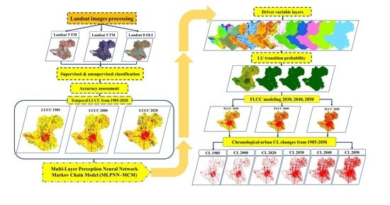
Remote Sensing-Based Urban Sprawl Modeling Using Multilayer Perceptron Neural Network Markov Chain in Baghdad, Iraq
Abstract
:1. Introduction
2. Materials and Methods
2.1. Study Area
2.2. Data Sources
2.3. Methodology
2.3.1. Image Processing, Software, and Data Analysis Method
2.3.2. Accuracy Assessment and Validation
2.3.3. Spatial Directional Change of Urban Sprawl
2.3.4. FLUCC Modeling
2.3.5. MLPNN-MCM
2.3.6. Determinants of Driving Factors for MCM
2.3.7. Transition Probability Modeling of LUCC
3. Results
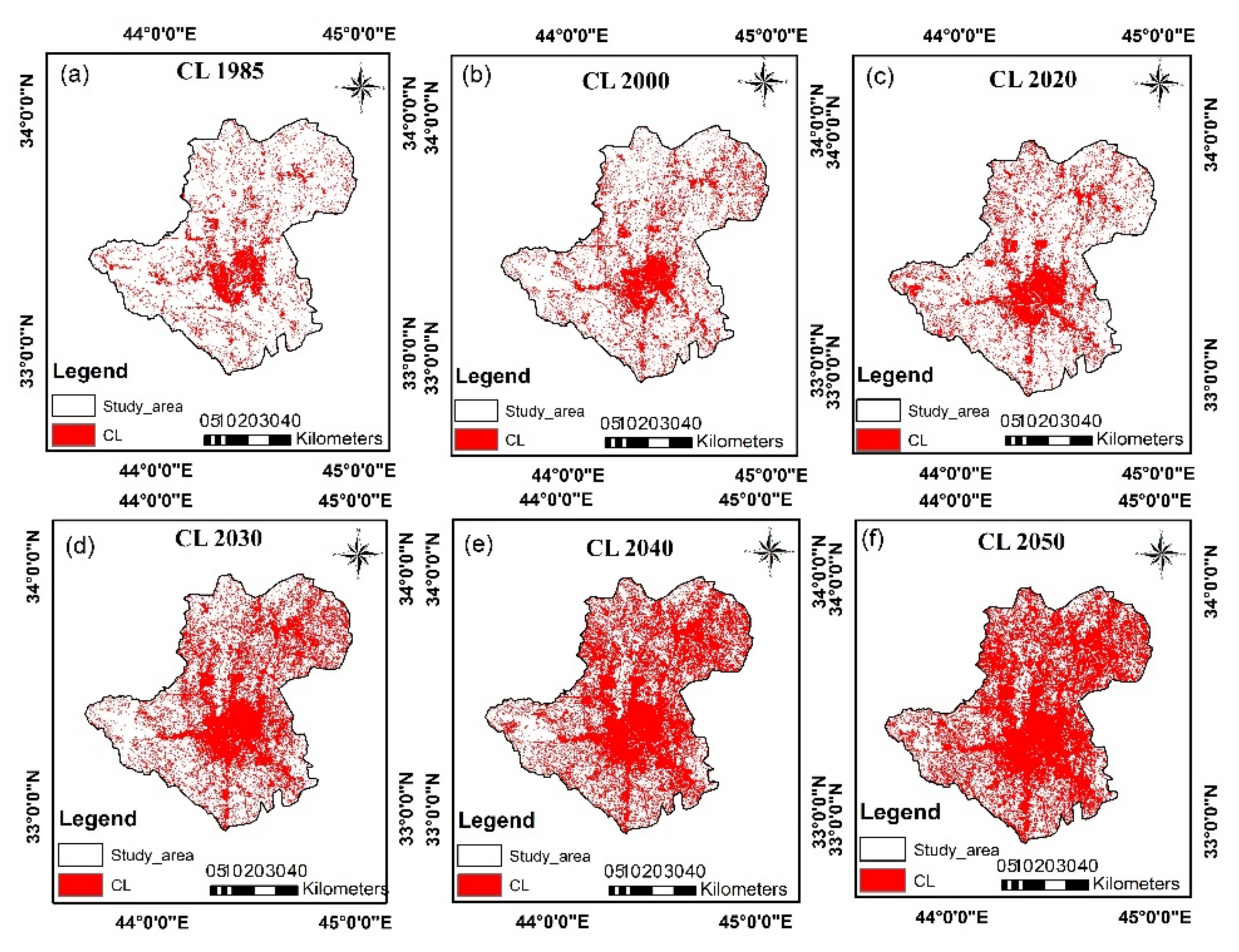
3.1. Spatial and Temporal Variation Trend Analysis of LUCC from 1995 to 2020
3.2. Analyzing City Expansions at Different Spatial Directions
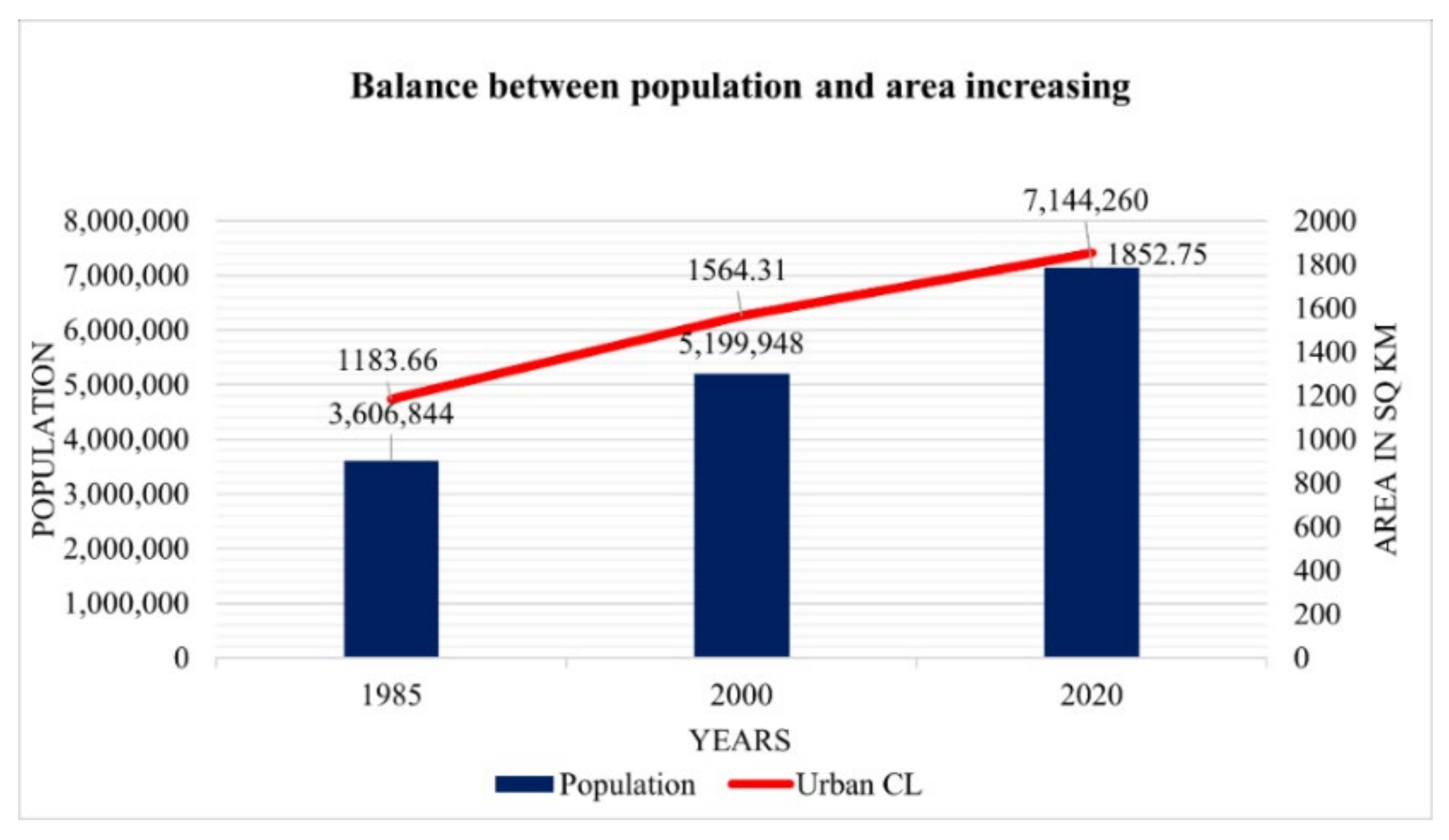
3.3. Effect of Population Growth to Urban CL
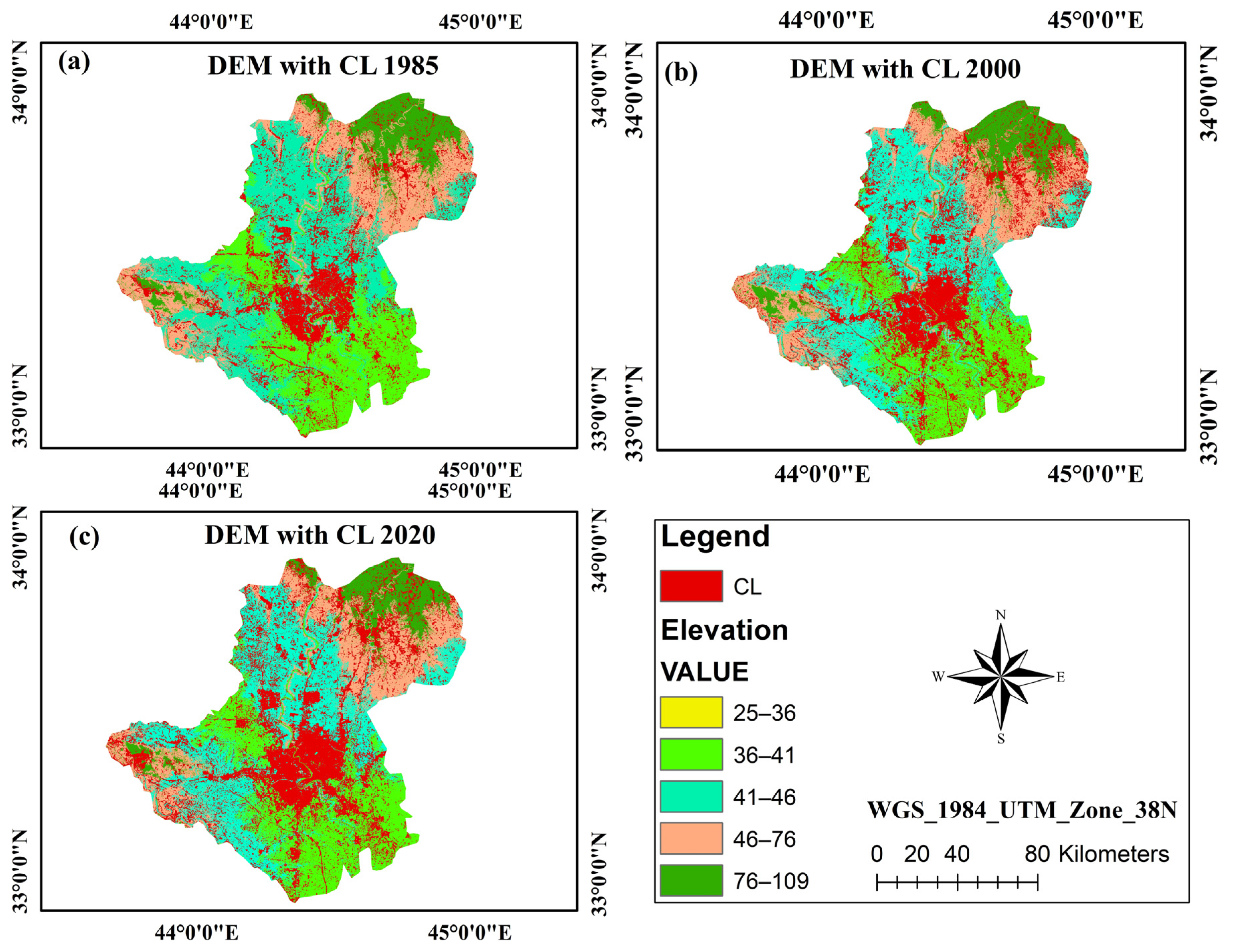
3.4. Urban CL Distributed Based on Geographic Perspectives
3.5. FLUCC Prediction Scenario
3.5.1. Validation of the Actual and Predicted LUCC in 2020
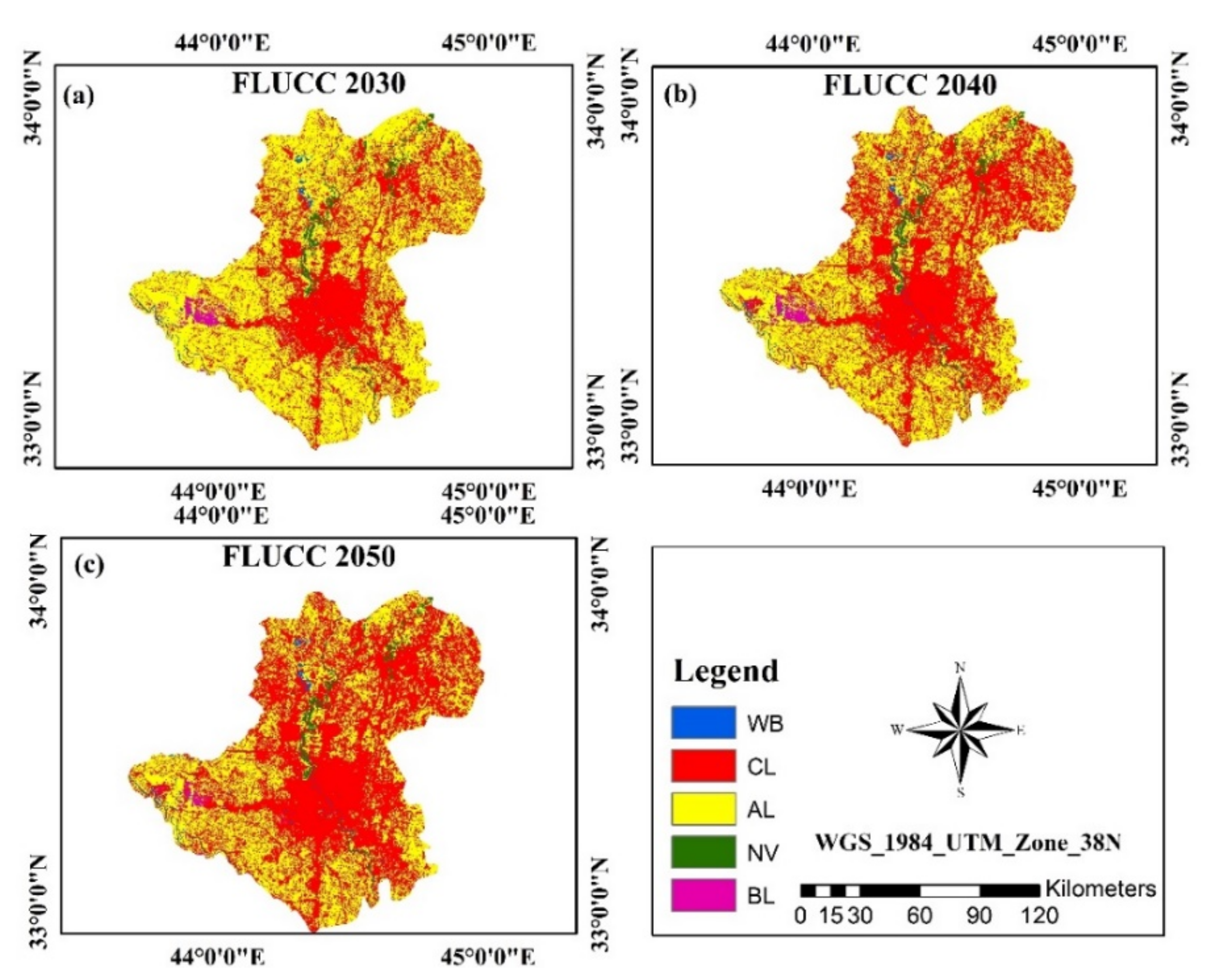
3.5.2. Simulation Scenario of FLUCC
4. Discussion
4.1. Accuracy of LUCC Classification and Future Modeling
4.2. Urban CL Expansion
4.3. Limitations, Suggestions, and Future Recommendations
5. Conclusions
Author Contributions
Funding
Acknowledgments
Conflicts of Interest
Appendix A

References
- Ahmed, F. The Use of Spatial Analysis and Participatory Approaches in Strategic Environmental Assessment (SEA): Identifying and Predicting the Ecological IMPACTS of Development on the KwaZulu-Natal North Coast of South Africa. Ph.D. Thesis, University of KwaZulu-Natal, Durban, South Africa, 2010. Available online: http://hdl.handle.net/10413/123 (accessed on 15 May 2021).
- Fazal, S. Land Use Dynamics in a Developing Economy: Regional Perspectives from India; Springer Briefs in Geography; Springer Netherlands: Aligrah city, The Netherlands, 2013. [Google Scholar]
- Faichia, C.; Tong, Z.; Zhang, J.; Liu, X.; Kazuva, E.; Ullah, K.; Al-Shaibah, B. Using RS Data-Based CA–Markov Model for Dynamic Simulation of Historical and Future LUCC in Vientiane, Laos. Sustainability 2020, 12, 8410. [Google Scholar] [CrossRef]
- Hoornweg, D.; Pope, K. Population predictions for the world’s largest cities in the 21st century. Environ. Urban. 2017, 29, 195–216. [Google Scholar] [CrossRef] [Green Version]
- Cohen, J.E. Human population grows up. Sci. Am. 2005, 293, 48–55. [Google Scholar] [CrossRef]
- Li, P. Urbanization and the New Phase of Growth in China. In Urbanization and Its Impact in Contemporary China, 1st ed.; Research Series on the Chinese Dream and China’s Development, Path; Li, P., Ed.; Springer: Singapore, 2019; pp. 1–20. [Google Scholar]
- Chauhan, R.P.; Gordon, M.L. A systematic review analyzing the prevalence and circulation of influenza viruses in swine population worldwide. Pathogens 2020, 9, 355. [Google Scholar] [CrossRef]
- Somvanshi, S.S. Monitoring spatial LULC changes and its growth prediction based on statistical models and earth observation datasets of Gautam Budh Nagar, Uttar Pradesh, India. Environ. Dev. Sustain. 2020, 22, 1073–1091. [Google Scholar] [CrossRef]
- Long, H.; Heilig, G.H.; Li, X.; Zhang, M. Socio-economic development and land-use change: Analysis of rural housing land transition in the Transect of the Yangtse River, China. Land Use Policy 2007, 24, 141–153. [Google Scholar] [CrossRef]
- Lambin, E.F.; Geist, H.J.; Lepers, E. Dynamics of land-use and land-cover change in tropical regions. Annu. Rev. Environ. Resour. 2003, 28, 205–241. [Google Scholar] [CrossRef] [Green Version]
- Li, X.; Chen, G.; Liu, X.; Liang, X.; Wang, S.; Chen, Y.; Pei, F.; Xu, X. A new global land-use and land-cover change product at a 1-km resolution for 2010 to 2100 based on human–environment interactions. Ann. Assoc. Am. Geogr. 2017, 107, 1040–1059. [Google Scholar] [CrossRef]
- Dale, V.H. The relationship between land-use change and climate change. Ecol. Appl. 1997, 7, 753–769. [Google Scholar] [CrossRef]
- Zhou, M. Urban Sprawl and Changes in Land-Use Efficiency in the Beijing–Tianjin–Hebei Region, China from 2000 to 2020: A Spatiotemporal Analysis Using Earth Observation Data. Remote Sens. 2021, 13, 2850. [Google Scholar] [CrossRef]
- Jaeger, J.A.G.; Bertiller, R.; Schwick, C.; Cavens, D.; Kienast, F. Urban permeation of landscapes and sprawl per capita: New measures of urban sprawl. Ecol. Indic. 2010, 10, 427–441. [Google Scholar] [CrossRef]
- Ahmed, S.J.; Bramley, G.; Verburg, P.H. Key Driving factors influencing urban growth: Spatial-statistical modelling with Clue-s. In Dhaka Megacity: Geospatial Perspectives on Urbanisation, Environment and Health; Dewan, A., Corner, R., Eds.; Springer Geography: Dhaka, Switzerland, 2014; pp. 123–145. [Google Scholar]
- Clarke, K.C. Cellular Automata and Agent-Based Models. In Handbook of Regional Science; Fischer, M., Nijkamp, P., Eds.; Springer: Berlin/Heidelberg, Germany, 2014; pp. 1217–1233. [Google Scholar]
- Armin, M.; Majidian, M.; Kheybari, V.G. Land Use/Land Cover Change Detection and Prediction in the Yasouj City Suburbs in Kohgiluyeh Va Boyerahmad Province in Iran. Arid Ecosyst. 2020, 10, 203–210. [Google Scholar] [CrossRef]
- Kotaridis, I.; Lazaridou, M. Environmental Change Detection Study in the Wider Area of Lignite Mines. Civ. Eng. Archit. 2018, 6, 108–114. [Google Scholar] [CrossRef]
- Mallupattu, K.P.; Reddy, J.R.S. Analysis of land use/land cover changes using remote sensing data and GIS at an Urban Area, Tirupati, India. Sci. World J. 2013, 2013, 268623. [Google Scholar] [CrossRef] [PubMed] [Green Version]
- Shamsi, F.S.R. Integrating Linear Programming and Analytical Hierarchical Processing in Raster-GIS to Optimize Land Use Pattern at Watershed Level. J. Appl. Sci. Environ. Manag. 2010, 14, 81–85. [Google Scholar]
- Hyandye, C.; Mandara, C.G.; Safari, J. GIS and Logit Regression Model Applications in Land Use/Land Cover Change and Distribution in Usangu Catchment. Am. J. Remote Sens. 2015, 3, 6–16. [Google Scholar] [CrossRef] [Green Version]
- Aitkenhead, M.J.; Aalders, I.H. Predicting land cover using GIS, Bayesian and evolutionary algorithm methods. J. Environ. Manag. 2009, 90, 236–250. [Google Scholar] [CrossRef]
- Memarian, H.; Balasundram, S.K.; Talib, J.B.; Sung, C.T.B.; Sood, A.M.; Abbaspour, K. Validation of CA-Markov for Simulation of Land Use and Cover Change in the Langat Basin, Malaysia. J. Geogr. Inf. Syst. 2012, 4, 542–554. [Google Scholar] [CrossRef] [Green Version]
- Khawaldah, H.A. A prediction of future land use/land cover in Amman area using GIS-based Markov Model and Remote Sensing. J. Geogr. Info. Syst. 2016, 8, 412–427. [Google Scholar] [CrossRef] [Green Version]
- Weng, Q. Land use change analysis in the Zhujiang Delta of China using satellite remote sensing, GIS and stochastic modelling. J. Environ. Manag. 2002, 64, 273–284. [Google Scholar] [CrossRef] [Green Version]
- Mitrea, C.; Lee, C.; Wu, Z. A comparison between neural networks and traditional forecasting methods: A case study. IJEBM 2009, 1, 11. [Google Scholar] [CrossRef]
- Frank, J.R.; Davey, N.; Hunt, S.P. Time series prediction and neural networks. J. Intell. Robot Syst. 2001, 31, 91–103. [Google Scholar] [CrossRef]
- Bengio, Y.; Frasconi, P.; Simard, P. The problem of learning long-term dependencies in recurrent networks. In Proceedings of the IEEE International Conference on Neural Networks, San Francisco, CA, USA, 28 March–1 April 1993. [Google Scholar]
- Wan, E.A. Finite Impulse Response Neural Networks with Applications in Time Series Prediction; Stanford University: Stanford, CA, USA, 1994. [Google Scholar]
- Menezes, J.M., Jr.; Barreto, G.A. A new look at nonlinear time series prediction with NARX recurrent neural network. In Proceedings of the Ninth Brazilian Symposium on Neural Networks (SBRN’06), Ribeirao Preto, Brazil, 23–27 October 2006. [Google Scholar]
- Gutierrez, S.R.; Solis, A.O.; Mukhopadhyay, S. Lumpy demand forecasting using neural networks. Int. J. Prod. 2008, 111, 409–420. [Google Scholar] [CrossRef]
- Dey, N.N.; Rakib, A.A.; Kafy, A.-A.; Raikwar, V. Geospatial modelling of changes in land use/land cover dynamics using Multi-layer perception Markov chain model in Rajshahi City, Bangladesh. Environ. Chall. 2021, 4, 100148. [Google Scholar] [CrossRef]
- Guan, D.; Weijun, G.; Kazuyuki, W.; Hidetoshi, F. Land use change of Kitakyushu based on landscape ecology and Markov model. J. Geogr. Sci. 2008, 18, 455–468. [Google Scholar] [CrossRef]
- Kumar, S.; Radhakrishnan, N.; Mathew, S. Land use change modelling using a Markov model and remote sensing. Geomat. Nat. Hazards Risk 2014, 5, 145–156. [Google Scholar] [CrossRef]
- Liping, C.; Yujun, S.; Saeed, S. Monitoring and predicting land use and land cover changes using remote sensing and GIS techniques—A case study of a hilly area, Jiangle, China. PLoS ONE 2018, 13, e0200493. [Google Scholar] [CrossRef]
- Graham, S. Cities Under Siege: The New Military Urbanism; Verso Books: New York, NY, USA, 2011; p. 402. [Google Scholar]
- Siebeneck, L.K.; Medina, R.M.; Yamada, I.; Hepner, G.F. Spatial and temporal analyses of terrorist incidents in Iraq, 2004–2006. Stud. Confl. Terror. 2009, 32, 591–610. [Google Scholar] [CrossRef]
- Mohamedmeki, M.Z.; Al-Mumaiz, M. Multi Land Use Approach Towards Sustainable Baghdad City: Bab Al-Muatham Garage as a Case Study. IOP Conf. Ser. Mater. Sci. Eng. 2020, 2, 27–35. [Google Scholar] [CrossRef]
- Qassim, Z.H.; Abduljabbar, H.M. Land cover change for Baghdad City in the period 1986 to 2019. AIP Conf. Proc. 2020, 2307, 020031. [Google Scholar]
- Al-Ramahi, F.K.M. Spatial analysis of Radon Gas concentration distrbuted at Baghdad City using remote sensing and geographic information system Techniquesd. Iraqi J. Agric. Sci. 2020, 51, 21–32. [Google Scholar]
- Hamdy, H.Q.; Mutlag, O.H. Land Cover Change Detection in Al-Karkh/Baghdad. Int. J. Sci. Res. 2020, 9, 412–417. [Google Scholar]
- Jones, L. Rapid Population Growth in Baghdad and Amman. The Middle East J. 1969, 23, 209–215. [Google Scholar]
- Sirkeci, I. Conflict, the Environment of Human Insecurity and Migration in Iraq in the Aftermath of 2003. In Rethinking Global Migration: Practices, Policies and Discourses in the European Neighbourhood; KORA & METU: Ankara, Turkey, 2008; pp. 161–175. [Google Scholar]
- Sirkeci, I. War in Iraq: Environment of insecurity and international migration. Int. Migr. 2005, 43, 197–214. [Google Scholar] [CrossRef]
- Almukhtar, S. The Effect of Urban Conflict and the Role of Community-Based Initiatives in Baghdad; Columbia University: New York, NY, USA, 2014. [Google Scholar]
- Matlhodi, B.; Kenabatho, P.K.; Parida, B.P.; Maphanyane, J.G. Analysis of the Future Land Use Land Cover Changes in the Gaborone Dam Catchment Using CA-Markov Model: Implications on Water Resources. Remote Sens. 2021, 13, 2427. [Google Scholar] [CrossRef]
- Amin, A. A Geographical Analysis of Urban Land Transformation in Srinagar City. Ph.D. Thesis, Aligarh Muslim University, Aligarh, India, 2012. [Google Scholar]
- Fattah, M.H.; Caso, F. A Brief History of Iraq; Infobase Publishing: New York, NY, USA, 2009. [Google Scholar]
- Baghdad Population 2021. Available online: https://worldpopulationreview.com (accessed on 12 July 2021).
- Abdulkareem, A.K.; Matrood, L.M.; Muter, S.A. Detection of the Change of Meteorological Season in Middle and Southern Iraq. Plant Arch. 2020, 20, 1028–1033. [Google Scholar]
- Ali, J.M.; Marsh, S.H.; Smith, M.J. A comparison between London and Baghdad surface urban heat islands and possible engineering mitigation solutions. Sustain. Cities Soc. 2017, 29, 159–168. [Google Scholar] [CrossRef] [Green Version]
- Chabuk, A.; Al-Ansari, N.; Hussain, H.M.; Laue, J.; Hazim, A.; Knutsson, S.; Pusch, R. Landfill sites selection using MCDM and comparing method of change detection for Babylon Governorate, Iraq. Environ. Sci. Pollut. Res. 2019, 35, 35325–35339. [Google Scholar] [CrossRef] [Green Version]
- Google Earth Pro. 2020. Available online: https://www.google.com/earth/download/gep/agree.html?hl=en-GB (accessed on 22 June 2021).
- USGS, Earth Explorer. Available online: https://earthexplorer.usgs.gov/ (accessed on 28 June 2021).
- Yang, X. Satellite Monitoring of Urban Spatial Growth in the Atlanta Metropolitan Area. Photogramm. Eng. Remote Sens. 2002, 68, 725–734. [Google Scholar]
- Abbas, Z.; Jaber, H.S. Accuracy assessment of supervised classification methods for extraction land use maps using remote sensing and GIS techniques. IOP Conf. Ser. Mater. Sci. Eng. 2020, 745, 012166. [Google Scholar] [CrossRef]
- OpenStreetMap. Online Mapping Project Database. 2021. Available online: http://www.openstreetmap.org/ (accessed on 11 July 2021).
- Mas, J.-F.; Velázquez, A.; Díaz-Gallegos, J.R.; Mayorga-Saucedo, R.; Alcántara, C.; Bocco, G.; Castro, R.; Fernández, T.; Pérez-Vega, A. Assessing land use/cover changes: A nationwide multidate spatial database for Mexico. Int. J. Appl. Earth Obs. Geoinf. 2004, 5, 249–261. [Google Scholar] [CrossRef]
- Parsa, V.A.; Salehi, E. Spatio-temporal analysis and simulation pattern of land use/cover changes, case study: Naghadeh, Iran. J. Urban Manag. 2016, 5, 43–51. [Google Scholar] [CrossRef] [Green Version]
- Rwanga, S.S.; Ndambuki, J.M. Accuracy assessment of land use/land cover classification using remote sensing and GIS. Int. J. Geosci. 2017, 8, 611. [Google Scholar] [CrossRef] [Green Version]
- Wang, S.W.; Gebru, B.M.; Lamchin, M.; Kayastha, R.B.; Lee, W.-K. Land use and land cover change detection and prediction in the Kathmandu district of Nepal using remote sensing and GIS. Sustainability 2020, 12, 3925. [Google Scholar] [CrossRef]
- Omar, N.Q.; Ahmad, M.S.S.; Wan Hussin, W.M.A.; Samat, N.; Ahmad, S.Z.B. Markov CA, multi regression, and multiple decision making for modeling historical changes in Kirkuk City, Iraq. J. Indian Soc. Remote Sens. 2014, 42, 165–178. [Google Scholar] [CrossRef]
- Hua, A.K. Land Use Land Cover Changes in Detection of Water Quality: A Study Based on Remote Sensing and Multivariate Statistics. J. Environ. Public Health 2017, 2017, 7515130. [Google Scholar] [CrossRef] [PubMed] [Green Version]
- Congalton, R.G. Accuracy assessment and validation of remotely sensed and other spatial information. Int. J. Wildland Fire 2001, 10, 321–328. [Google Scholar] [CrossRef] [Green Version]
- Kafy, A.-A.; Rakib, A.A.; Akter, K.S.; Rahaman, Z.A.; Faisal, A.-A.; Mallik, S.; Nasher, N.M.R.; Hossain, M.I.; Ali, M.Y. Monitoring the effects of vegetation cover losses on land surface temperature dynamics using geospatial approach in Rajshahi city, Bangladesh. Environ. Chall. 2021, 4, 100187. [Google Scholar] [CrossRef]
- Kafy, A.-A.; Naim, M.N.H.; Subramanyam, G.; Faisal, A.-A.; Ahmed, N.U.; Rakib, A.A.; Kona, M.A.; Sattar, G.S. Cellular Automata approach in dynamic modelling of land cover changes using RapidEye images in Dhaka, Bangladesh. Environ. Chall. 2021, 4, 100084. [Google Scholar] [CrossRef]
- Cao, H.; Liu, J.; Fu, C.; Zhang, W.; Wang, G.; Luo, L. Urban Expansion and Its Impact on the Land Use Pattern in Xishuangbanna since the Reform and Opening up of China. Remote Sens. 2017, 9, 137. [Google Scholar] [CrossRef] [Green Version]
- Dzieszko, P. Land-cover modelling using corine land cover data and multi-layer perceptron. Quaest. Geogr. 2014, 33, 5–22. [Google Scholar] [CrossRef] [Green Version]
- Roy, S.; Farzana, K.; Papia, M.; Hasan, M. Monitoring and prediction of land use/land cover change using the integration of Markov chain model and cellular automation in the Southeastern Tertiary Hilly Area of Bangladesh. Int. J. Sci. Basic Appl. Res. 2015, 24, 125–148. [Google Scholar]
- Dadhich, P.N.; Hanaoka, S. Markov method integration with multi-layer perceptron classifier for simulation of urban growth of Jaipur City. In Proceedings of the 6th WSEAS International Conference on Remote Sensing, Iwate, Japan, 4–6 October 2010; pp. 118–123. [Google Scholar]
- Dixon, B.; Candade, N. Multispectral landuse classification using neural networks and support vector machines: One or the other, or both? Int. J. Remote Sens. 2008, 29, 1185–1206. [Google Scholar] [CrossRef]
- Lin, Y.-P.; Chu, H.-J.; Wu, C.-F.; Verburg, P.H. Predictive ability of logistic regression, auto-logistic regression and neural network models in empirical land-use change modeling–a case study. Int. J. Geogr. Inf. Sci. 2011, 25, 65–87. [Google Scholar] [CrossRef] [Green Version]
- Shen, L.; Li, J.B.; Wheate, R.; Yin, J.; Paul, S.S. Multi-layer perceptron neural network and Markov chain based geospatial analysis of land use and land cover change. J. Environ. Inform. Lett. 2020, 3, 29–39. [Google Scholar] [CrossRef]
- Friesner, R.A.; Banks, J.L.; Murphy, R.B.; Halgren, T.A.; Klicic, J.J.; Mainz, D.T.; Repasky, M.P.; Knoll, E.H.; Shelley, M.; Perry, J.K.; et al. Glide: A New Approach for Rapid, Accurate Docking and Scoring. 1. Method and Assessment of Docking Accuracy. J. Med. Chem. 2004, 47, 1739–1749. [Google Scholar] [CrossRef]
- Gümrah, F.; Öz, B.; Güler, B.; Evin, S. The application of artificial neural networks for the prediction of water quality of polluted aquifer. Water Air Soil Pollut. 2000, 119, 275–294. [Google Scholar] [CrossRef]
- Hsu, L.-C. Applying the grey prediction model to the global integrated circuit industry. Technol. Forecast. Soc. Change 2003, 70, 563–574. [Google Scholar] [CrossRef]
- Arsanjani, J.J.; Kainz, W.; Mousivand, A.J. Tracking dynamic land-use change using spatially explicit Markov Chain based on cellular automata: The case of Tehran. Int. J. Image Data Fusion 2011, 2, 329–345. [Google Scholar] [CrossRef]
- Qian, Y.; Wu, Z. Study on Urban Expansion Using the Spatial and Temporal Dynamic Changes in the Impervious Surface in Nanjing. Sustainability 2019, 11, 933. [Google Scholar] [CrossRef] [Green Version]
- Rimal, B.; Sloan, S.; Keshtkar, H.; Sharma, R.; Rijal, S.; Shrestha, U.B. Patterns of Historical and Future Urban Expansion in Nepal. Remote Sens. 2020, 12, 628. [Google Scholar] [CrossRef] [Green Version]




| Satellite | Sensor | Resolution (m) | Path/Row | Acquisition Date | Season | Cloud Cover (%) |
|---|---|---|---|---|---|---|
| Landsat 5 | TM | 30 × 30 | 169/037 | 20 July 1985 | Dry | 0 |
| Landsat 5 | TM | 30 × 30 | 169/037 | 29 July 2000 | Dry | 2 |
| Landsat 8 | OLI | 30 × 30 | 169/037 | 22 August 2020 | Dry | 1.17 |
| LUCC Class | Users’ Accuracy (%) | Producers’ Accuracy (%) | Overall Accuracy (%) | Overall Kappa Statistic | ||||||||
|---|---|---|---|---|---|---|---|---|---|---|---|---|
| 1985 | 2000 | 2020 | 1985 | 2000 | 2020 | 1985 | 2000 | 2020 | 1985 | 2000 | 2020 | |
| WB | 100 | 99 | 95 | 100 | 100 | 95 | 86 | 91 | 90 | 0.82 | 0.89 | 0.91 |
| CL | 98 | 91 | 94 | 95 | 87 | 95 | ||||||
| AL | 90 | 93 | 89 | 89 | 92 | 87 | ||||||
| NV | 96 | 98 | 100 | 94 | 100 | 100 | ||||||
| BL | 96 | 99 | 99 | 95 | 100 | 100 | ||||||
| Indicators | Predicted |
|---|---|
| 0.8003 | |
| 0.9552 | |
| 0.8902 | |
| 0.9334 |
| LU/CC Types | Area (km2) | Net Change (km2) | ||||
|---|---|---|---|---|---|---|
| 1985 | 2000 | 2020 | 1985–2000 | 2000–2020 | 1985–2020 | |
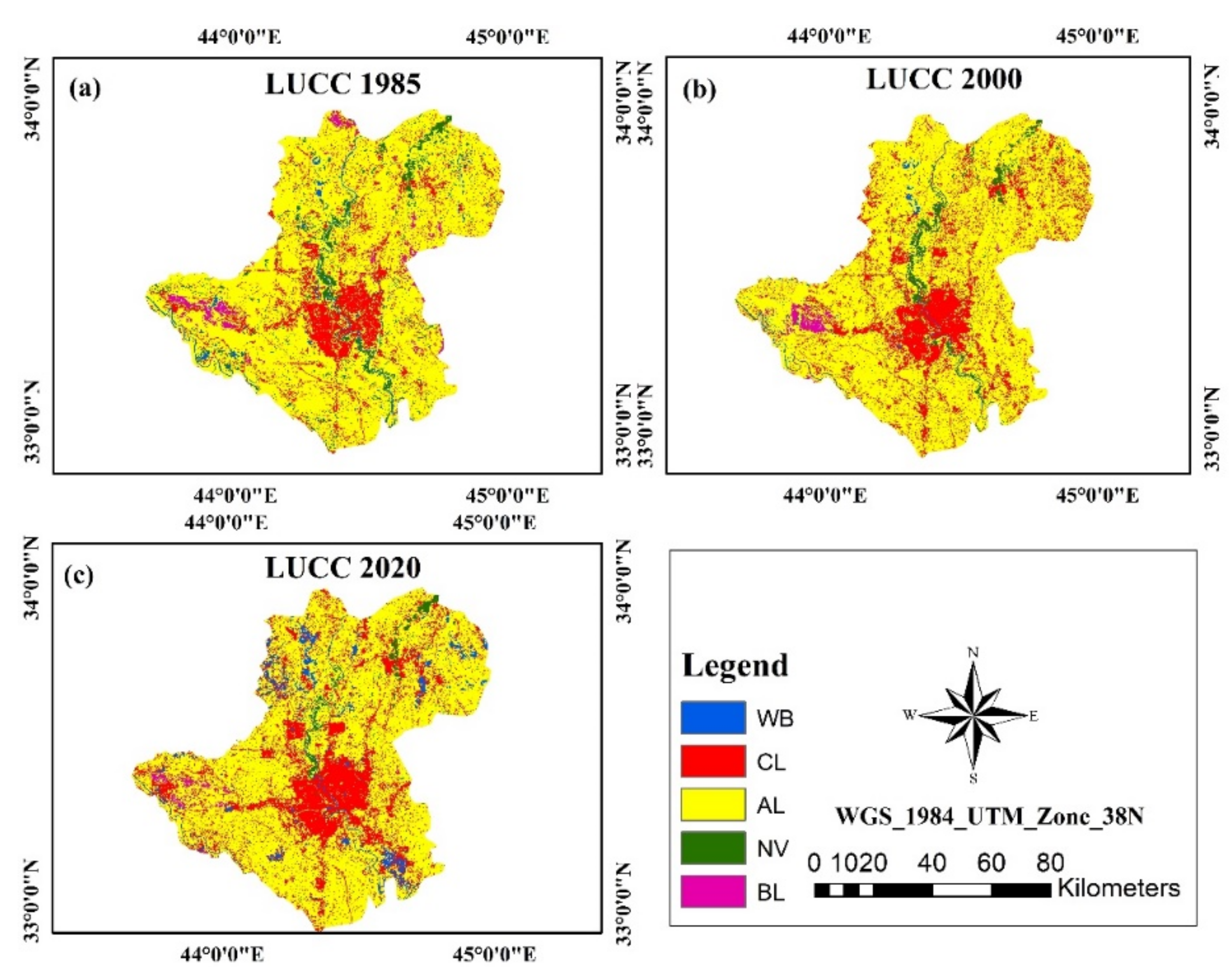
| WB | 167 | 106.32 | 350.16 | −60.69 | 243.84 | 183.16 |
| CL | 1183.66 | 1564.31 | 1852.75 | 380.65 | 288.44 | 669.09 |
| AL | 5737.45 | 5703.28 | 5247.99 | −34.17 | −455.29 | −489.46 |
| NV | 434.06 | 220.14 | 167.72 | −213.92 | −52.43 | −266.35 |
| BL | 176.82 | 109.51 | 86.44 | −67.31 | −23.06 | −90.38 |
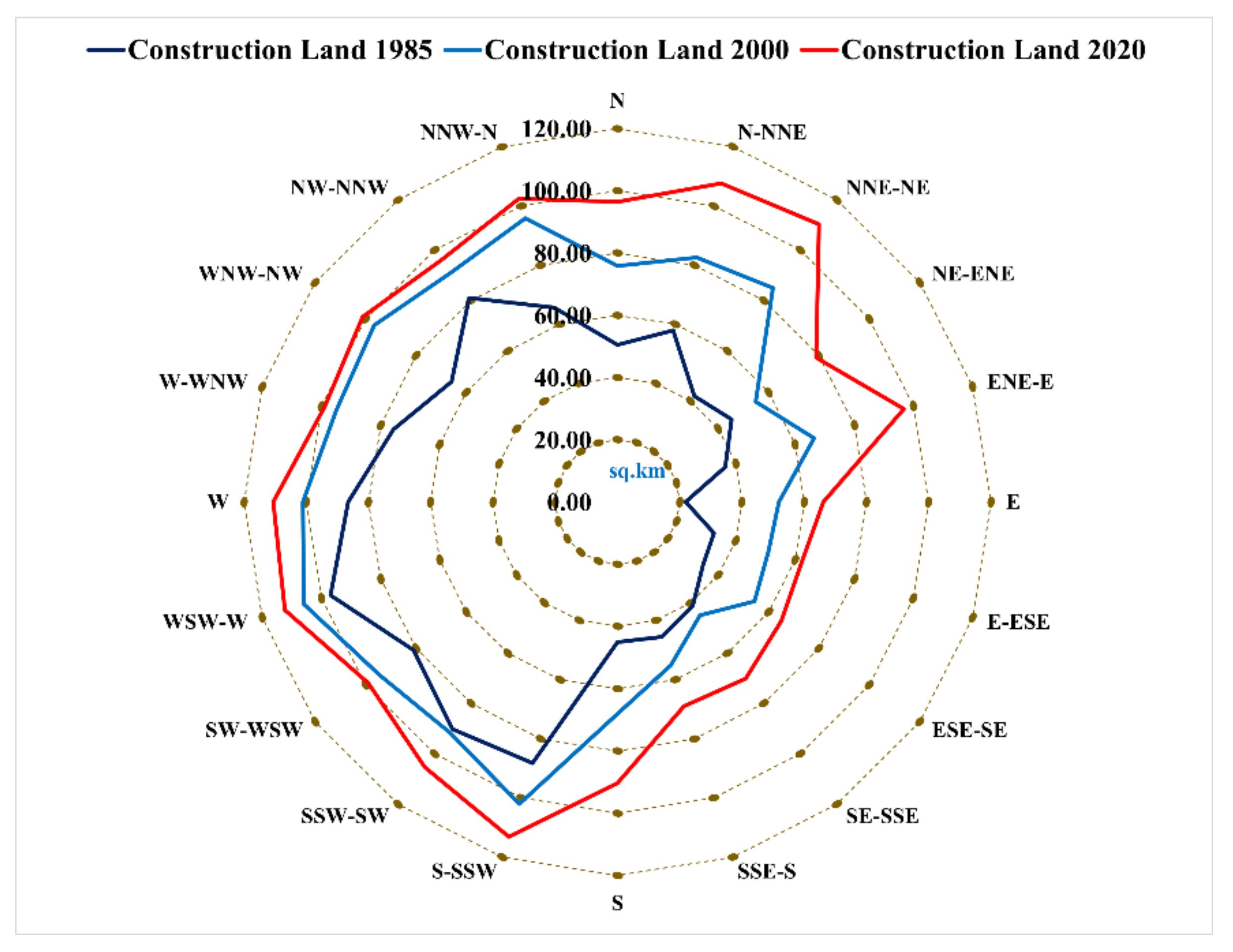
| Direction | CL 1985 | CL 2000 | CL 2020 |
|---|---|---|---|
| N | 50.54 | 75.85 | 96.41 |
| N-NNE | 58.02 | 82.55 | 107.69 |
| NNE-NE | 42.06 | 85.01 | 110.23 |
| NE-ENE | 45.25 | 54.88 | 78.93 |
| ENE-E | 36.43 | 66.43 | 96.76 |
| E | 21.92 | 51.88 | 66.13 |
| E-ESE | 32.57 | 51.02 | 62.27 |
| ESE-SE | 34.05 | 54.33 | 65.02 |
| SE-SSE | 41.25 | 45.02 | 70.16 |
| SSE-S | 45.65 | 55.25 | 68.94 |
| S | 45.01 | 68.04 | 90.29 |
| S-SSW | 88.25 | 102.01 | 113.08 |
| SSW-SW | 90.24 | 91.62 | 105.31 |
| SW-WSW | 81.02 | 94.50 | 99.05 |
| WSW-W | 96.98 | 106.01 | 112.37 |
| W | 86.55 | 101.03 | 110.59 |
| W-WNW | 75.65 | 95.05 | 98.93 |
| WNW-NW | 65.85 | 96.55 | 101.21 |
| NW-NNW | 81.06 | 91.09 | 96.20 |
| NNW-N | 65.65 | 95.88 | 102.43 |
| Elevation | 1985 | 2000 | 2020 | |||
|---|---|---|---|---|---|---|
| km2 | % | km2 | % | km2 | % | |
| 25–36 | 204.35 | 17.26 | 368.35 | 23.55 | 318.39 | 17.18 |
| 36–41 | 724.74 | 61.23 | 912.84 | 58.35 | 1058.76 | 57.15 |
| 41–46 | 148.86 | 12.58 | 231.87 | 14.82 | 311.17 | 16.80 |
| 46–78 | 74 | 6.25 | 94.18 | 6.02 | 205.29 | 11.08 |
| 78−109 | 31.71 | 2.68 | 42.93 | 2.74 | 40.2 | 2.17 |
| Total | 1183.66 | 100 | 1564.31 | 100 | 1852.75 | 100 |
| Slope | 1985 | 2000 | 2020 | |||
|---|---|---|---|---|---|---|
| km2 | % | km2 | % | km2 | % | |
| 0–1.22 | 106.35 | 8.98 | 268.35 | 17.15 | 300.39 | 16.21 |
| 1.22–2.26 | 842.74 | 71.20 | 1022.84 | 65.39 | 1076.76 | 58.12 |
| 2.26–3.64 | 169.86 | 14.35 | 270.87 | 17.32 | 413.17 | 22.30 |
| 3.64–6.20 | 54 | 4.56 | 64.18 | 4.10 | 112.31 | 6.06 |
| 6.20–89.89 | 10.71 | 0.90 | 33.93 | 2.17 | 30 | 1.62 |
| Total | 1183.66 | 100 | 1564.31 | 100 | 1852.75 | 100 |
| LU Types | Actual LU 2020 (km2) | Predicted LU 2020 (km2) | Area Different (km2) | Percentage Different (%) |
|---|---|---|---|---|
| WB | 350.159 | 298.1945 | −51.965 | −14.84 |
| CL | 1852.75 | 1959.11 | 106.36 | 5.74 |
| AL | 5247.99 | 5336.44 | 88.45 | 1.69 |
| NV | 167.716 | 186.742 | 19.026 | 11.34 |
| BL | 86.4441 | 98.2044 | 11.7603 | 13.60 |
| LU Types | Area 2030 | Area 2040 | Area 2050 | |||
|---|---|---|---|---|---|---|
| km2 | % | km2 | % | km2 | % | |
| WB | 74.71 | 0.97 | 96.64 | 1.26 | 92.24 | 1.20 |
| CL | 2803.59 | 36.55 | 3719.08 | 48.49 | 4357.16 | 56.81 |
| AL | 4552.19 | 59.35 | 3615.76 | 47.14 | 3048.09 | 39.74 |
| NL | 176.05 | 2.30 | 168.20 | 2.19 | 146.81 | 1.91 |
| BL | 92.15 | 1.20 | 70.01 | 0.91 | 54.38 | 0.71 |
| Total | 7669.69 | 100 | 7669.69 | 100 | 7669.69 | 100 |
Publisher’s Note: MDPI stays neutral with regard to jurisdictional claims in published maps and institutional affiliations. |
© 2021 by the authors. Licensee MDPI, Basel, Switzerland. This article is an open access article distributed under the terms and conditions of the Creative Commons Attribution (CC BY) license (https://creativecommons.org/licenses/by/4.0/).
Share and Cite
Al-Hameedi, W.M.M.; Chen, J.; Faichia, C.; Al-Shaibah, B.; Nath, B.; Kafy, A.-A.; Hu, G.; Al-Aizari, A. Remote Sensing-Based Urban Sprawl Modeling Using Multilayer Perceptron Neural Network Markov Chain in Baghdad, Iraq. Remote Sens. 2021, 13, 4034. https://doi.org/10.3390/rs13204034
Al-Hameedi WMM, Chen J, Faichia C, Al-Shaibah B, Nath B, Kafy A-A, Hu G, Al-Aizari A. Remote Sensing-Based Urban Sprawl Modeling Using Multilayer Perceptron Neural Network Markov Chain in Baghdad, Iraq. Remote Sensing. 2021; 13(20):4034. https://doi.org/10.3390/rs13204034
Chicago/Turabian StyleAl-Hameedi, Wafaa Majeed Mutashar, Jie Chen, Cheechouyang Faichia, Bazel Al-Shaibah, Biswajit Nath, Abdulla-Al Kafy, Gao Hu, and Ali Al-Aizari. 2021. "Remote Sensing-Based Urban Sprawl Modeling Using Multilayer Perceptron Neural Network Markov Chain in Baghdad, Iraq" Remote Sensing 13, no. 20: 4034. https://doi.org/10.3390/rs13204034
APA StyleAl-Hameedi, W. M. M., Chen, J., Faichia, C., Al-Shaibah, B., Nath, B., Kafy, A.-A., Hu, G., & Al-Aizari, A. (2021). Remote Sensing-Based Urban Sprawl Modeling Using Multilayer Perceptron Neural Network Markov Chain in Baghdad, Iraq. Remote Sensing, 13(20), 4034. https://doi.org/10.3390/rs13204034


