Remote Sensing Supported Sea Surface pCO2 Estimation and Variable Analysis in the Baltic Sea


Abstract
1. Introduction
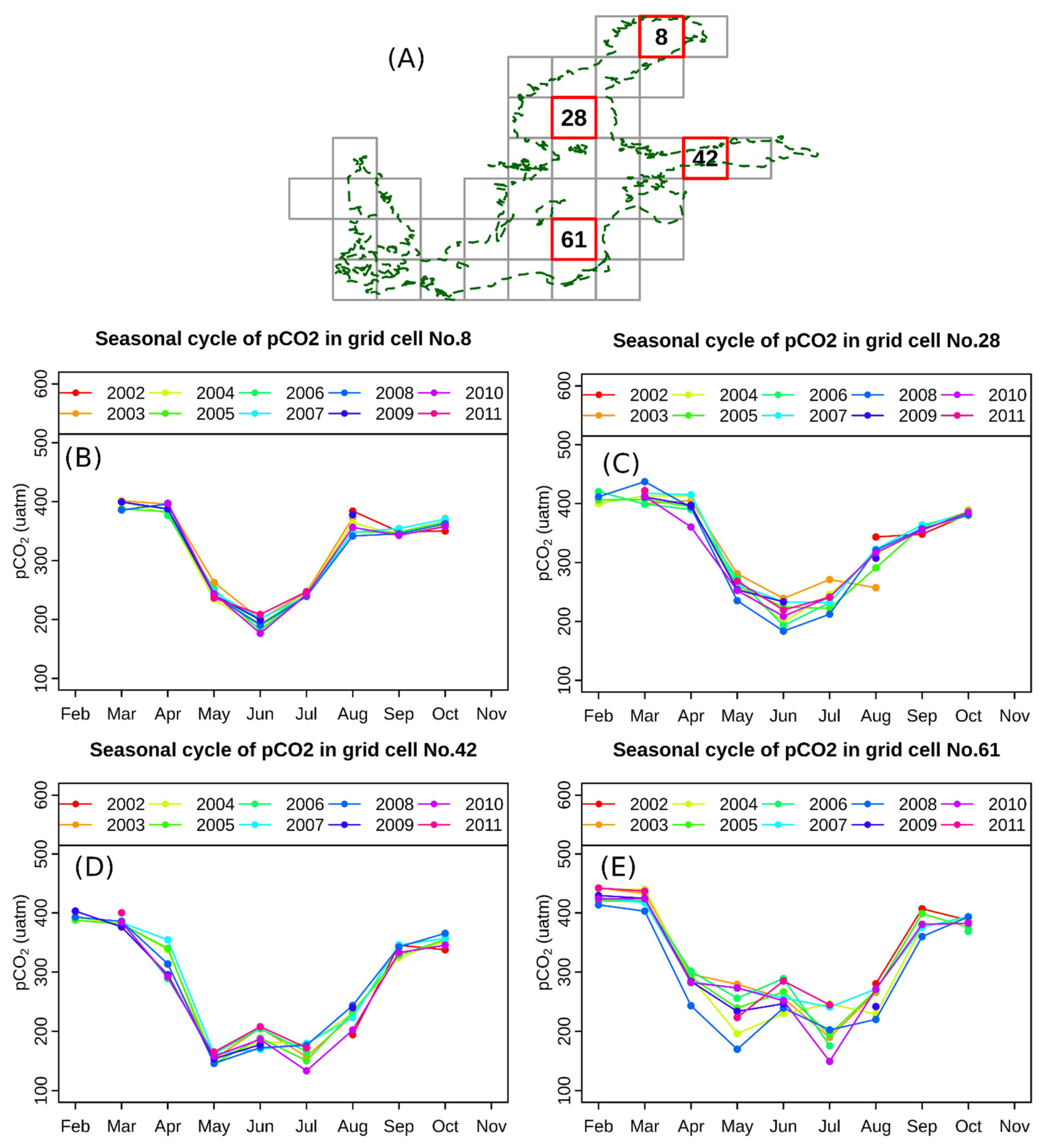
2. Study Area
3. Data
3.1. Remote Sensing Products
3.2. Modeled Data
3.3. In-Situ Data
4. Methods
4.1. Random Forest
4.2. Filtering In-Situ Data
4.3. Analyzing Variables’ Importance for pCO2 Estimation
4.4. Constructing the Fnal Model for pCO2 Estimation in the Baltic Sea
4.5. Comparing the Random Forest to Self-Organized Map (SOM) and Multiple Linear Regression (MLR) for pCO2 Estimation in the Baltic Sea
5. Results
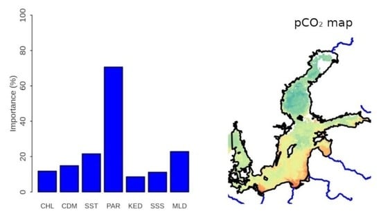
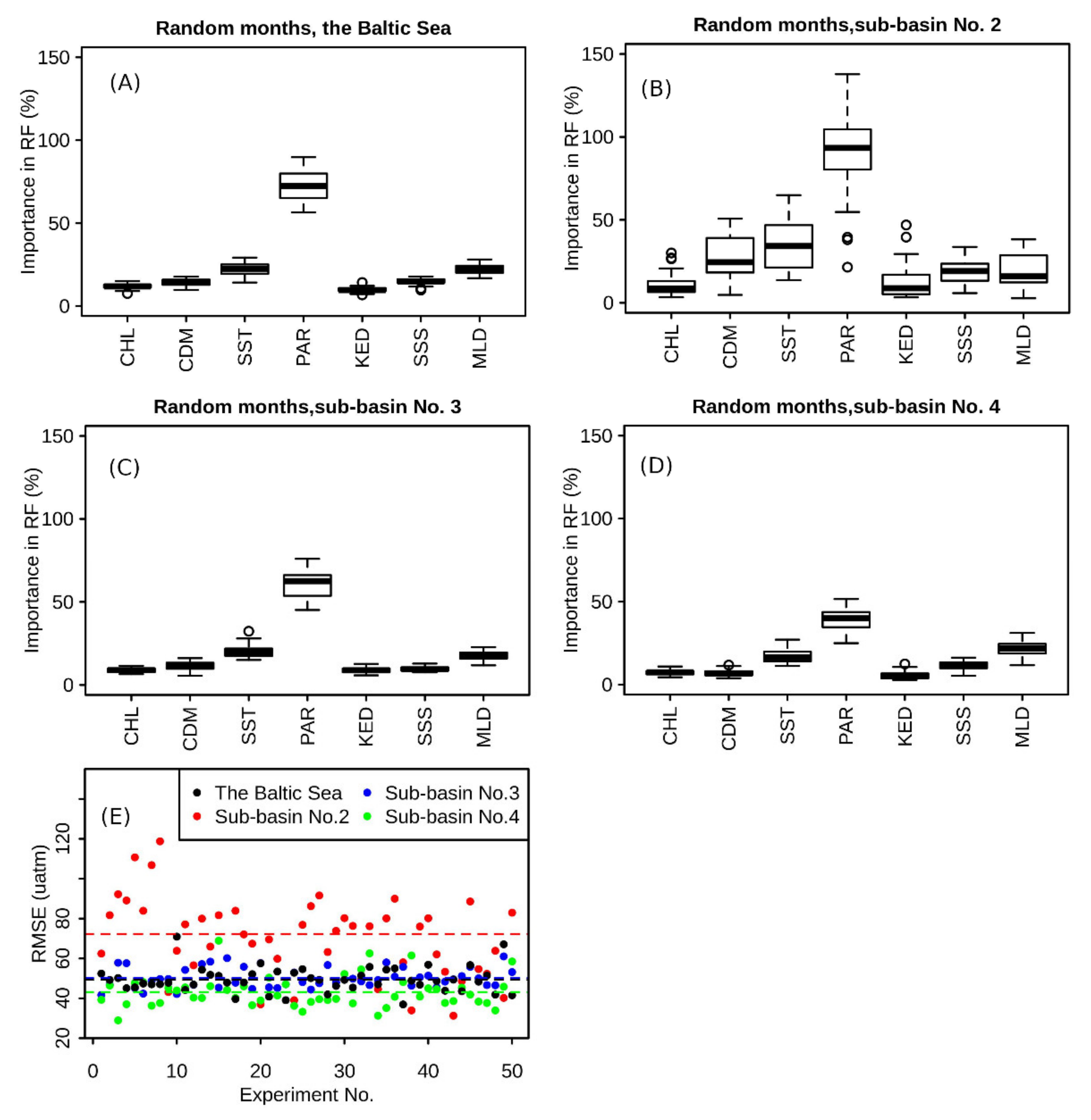
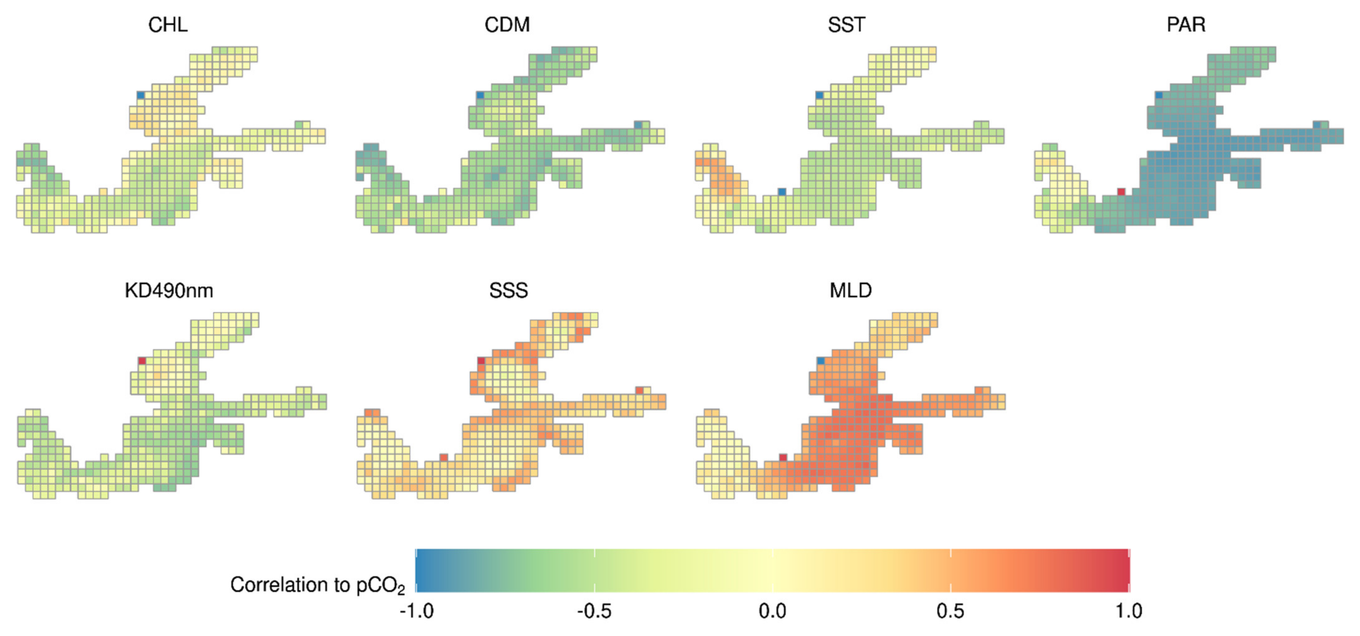
5.1. Spatiotemporal Characteristics of Variable Importance to pCO2 Estimation
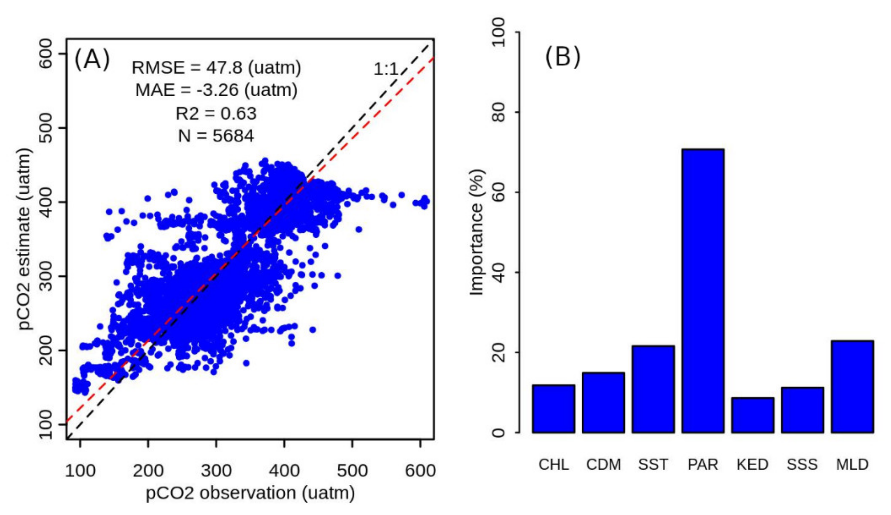
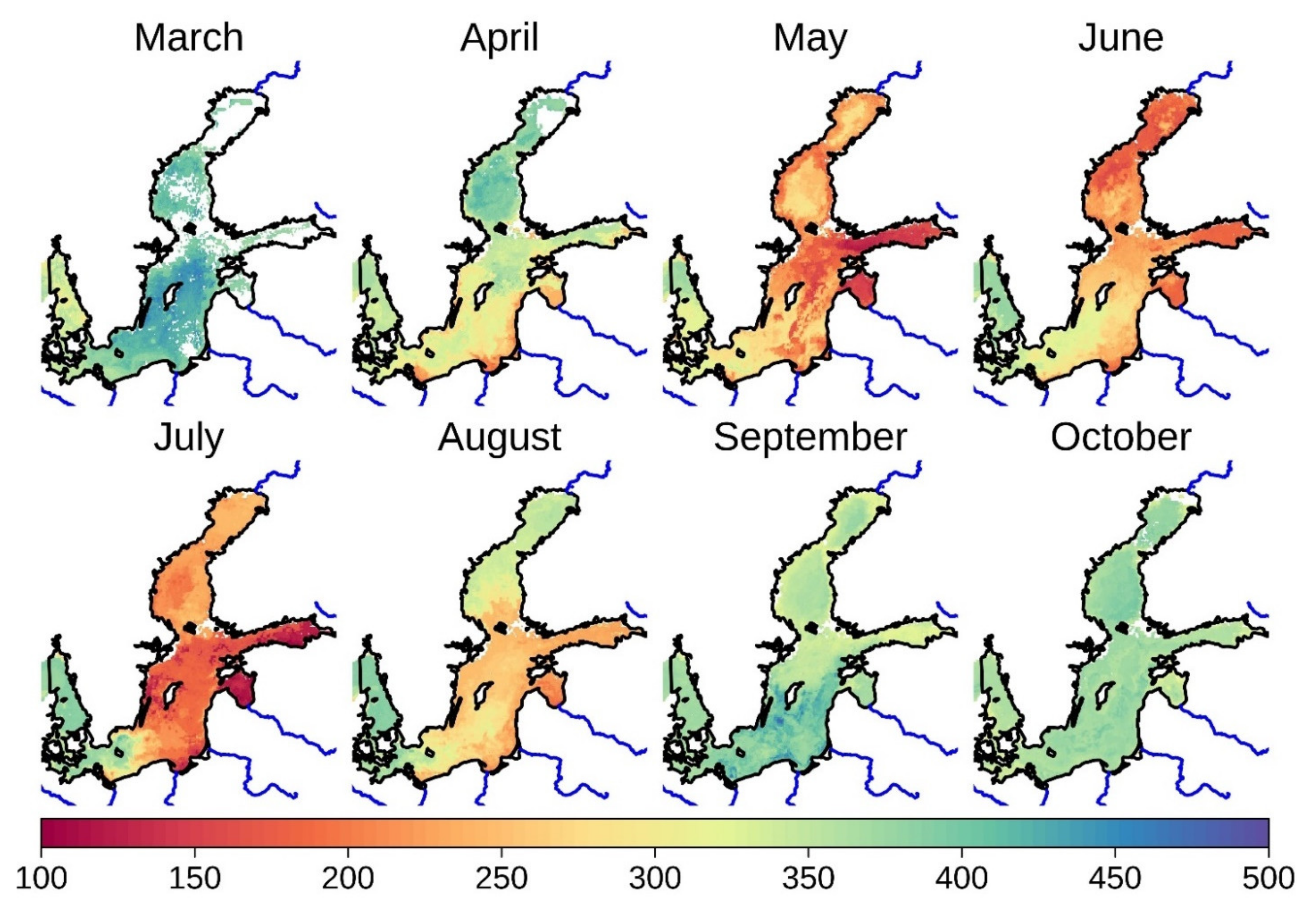
5.2. pCO2 Maps from Final Random Forest Model
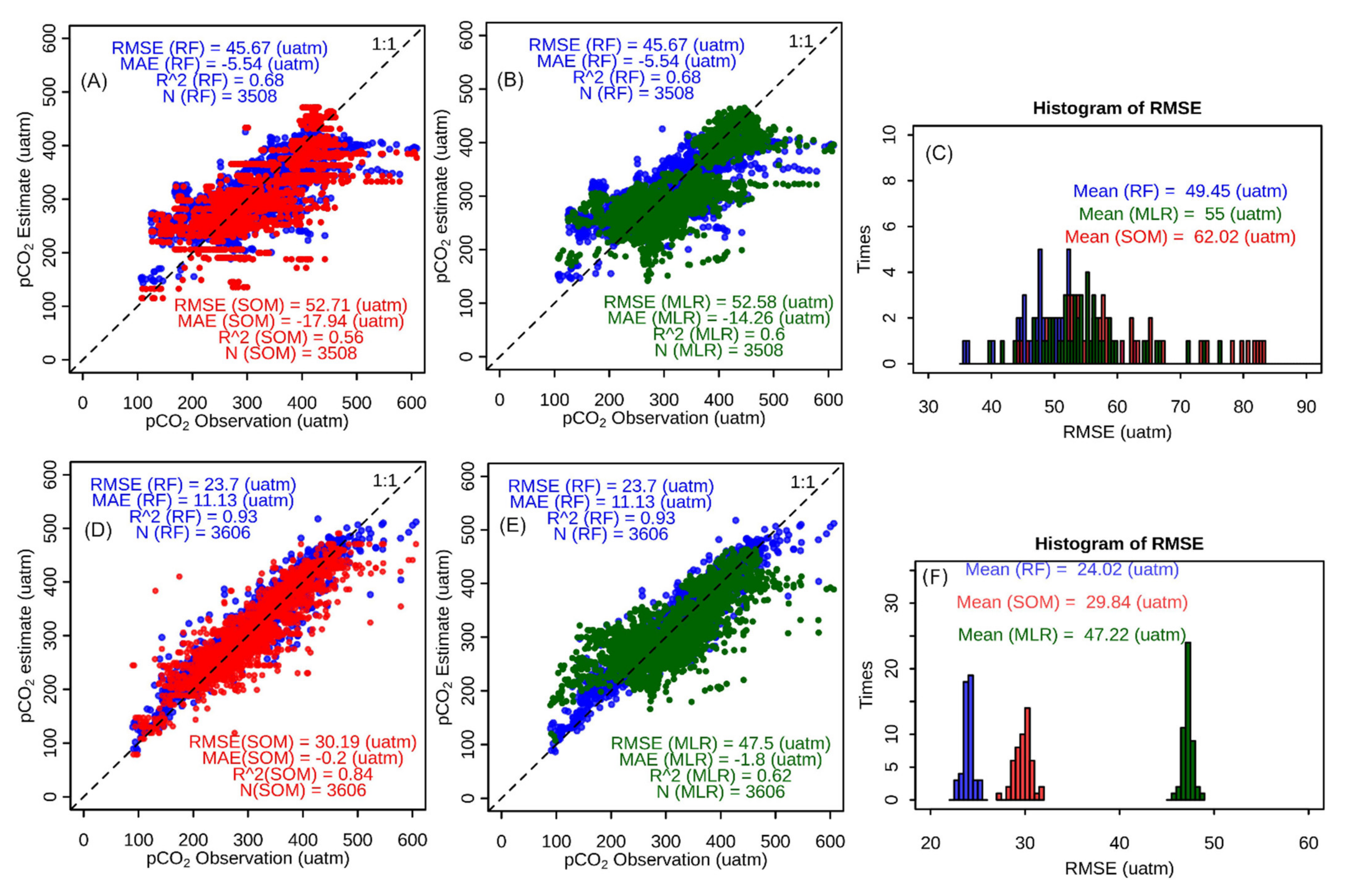
5.3. Comparison of Random Forest and SOM
6. Discussion
6.1. Characteristics of Variable Contribution to the pCO2 Estimate
6.2. Impact of Unbalanced In-Situ Measurements Distribution on the Model for pCO2 Estimate
6.3. pCO2 Maps for the Baltic Sea and Its Spatiotemporal Characteristics
7. Conclusions
Supplementary Materials
Author Contributions
Funding
Institutional Review Board Statement
Informed Consent Statement
Data Availability Statement
Acknowledgments
Conflicts of Interest
References
- Gruber, N.; Clement, D.; Carter, B.R.; Feely, R.A.; Van Heuven, S.; Hoppema, M.; Ishii, M.; Key, R.M.; Kozyr, A.; Lauvset, S.K.; et al. The oceanic sink for anthropogenic CO2 from 1994 to 2007. Science 2019, 363, 1193–1199. [Google Scholar] [CrossRef]
- Laruelle, G.G.; Cai, W.; Hu, X.; Gruber, N.; MacKenzie, F.T.; Regnier, P. Continental shelves as a variable but increasing global sink for atmospheric carbon dioxide. Nat. Commun. 2018, 9, 1–11. [Google Scholar] [CrossRef]
- Gruber, N. Carbon at the coastal interface. Nat. Cell Biol. 2015, 517, 148–149. [Google Scholar] [CrossRef]
- Laruelle, G.G.; Lauerwald, R.; Pfeil, B.; Regnier, P. Regionalized global budget of the CO2exchangeat the air-water interface in continental shelf seas. Glob. Biogeochem. Cycles 2014, 28, 1199–1214. [Google Scholar] [CrossRef]
- Hofmann, E.E.; Cahill, B.; Fennel, K.; Friedrichs, M.A.; Hyde, K.; Lee, C.; Mannino, A.; Najjar, R.G.; O’Reilly, J.E.; Wilkin, J.; et al. Modeling the Dynamics of Continental Shelf Carbon. Annu. Rev. Mar. Sci. 2011, 3, 93–122. [Google Scholar] [CrossRef]
- Fennel, K.; Wilkin, J.; Previdi, M.; Najjar, R. Denitrification effects on air-sea CO2 flux in the coastal ocean.pdf. Geophys. Res. Lett. 2008, 35, 1–5. [Google Scholar] [CrossRef]
- Xue, L.; Cai, W.-J.; Hu, X.; Sabine, C.L.; Jones, S.M.; Sutton, A.J.; Jiang, L.-Q.; Reimer, J.J. Sea surface carbon dioxide at the Georgia time series site (2006–2007): Air–sea flux and controlling processes. Prog. Oceanogr. 2016, 140, 14–26. [Google Scholar] [CrossRef]
- Schneider, B.; Müller, J.D. Biogeochemical Transformations in the Baltic Sea–Observations through Carbon Dioxide Glasses; Springer: Berlin/Heidelberg, Germany, 2018; ISBN 978-3-319-61698-8. [Google Scholar]
- Chierici, M.; Signorini, S.R.; Mattsdotter-Björk, M.; Fransson, A.; Olsen, A. Surface water fCO2 algorithms for the high-latitude Pacific sector of the Southern Ocean. Remote Sens. Environ. 2012, 119, 184–196. [Google Scholar] [CrossRef]
- Chen, S.; Hu, C.; Cai, W.; Yang, B. Estimating surface pCO2 in the northern Gulf of Mexico: Which remote sensing model to use? Cont. Shelf Res. 2017, 151, 94–110. [Google Scholar] [CrossRef]
- Jo, Y.-H.; Dai, M.; Zhai, W.; Yan, X.-H.; Shang, S. On the variations of sea surfacepCO2in the northern South China Sea: A remote sensing based neural network approach. J. Geophys. Res. Space Phys. 2012, 117, 1–13. [Google Scholar] [CrossRef]
- Parard, G.; Charantonis, A.A.; Rutgersson, A. Remote sensing the sea surface CO2 of the Baltic Sea using the SOMLO methodology. Biogeosciences 2015, 12, 3369–3384. [Google Scholar] [CrossRef]
- Fay, A.R.; McKinley, G. Correlations of surface ocean pCO2 to satellite chlorophyll on monthly to interannual timescales. Glob. Biogeochem. Cycles 2017, 31, 436–455. [Google Scholar] [CrossRef]
- Gustafsson, E.; Omstedt, A.; Gustafsson, B.G. The air-water CO2 exchange of a coastal sea—A sensitivity study on factors that influence the absorption and outgassing of CO2 in the Baltic Sea. J. Geophys. Res. Oceans 2015, 120, 5342–5357. [Google Scholar] [CrossRef]
- Gustafsson, E.; Deutsch, B.; Gustafsson, B.; Humborg, C.; Mörth, C.-M. Carbon cycling in the Baltic Sea—The fate of allochthonous organic carbon and its impact on air–sea CO2 exchange. J. Mar. Syst. 2014, 129, 289–302. [Google Scholar] [CrossRef]
- Chen, S.; Hu, C.; Barnes, B.B.; Wanninkhof, R.; Cai, W.-J.; Barbero, L.; Pierrot, D. A machine learning approach to estimate surface ocean pCO2 from satellite measurements. Remote Sens. Environ. 2019, 228, 203–226. [Google Scholar] [CrossRef]
- Lohrenz, S.E.; Cai, W.; Chakraborty, S.; Huang, W.-J.; Guo, X.; He, R.; Xue, Z.G.; Fennel, K.; Howden, S.; Tian, H. Satellite estimation of coastal pCO2 and air-sea flux of carbon dioxide in the northern Gulf of Mexico. Remote Sens. Environ. 2018, 207, 71–83. [Google Scholar] [CrossRef]
- Ikawa, H.; Faloona, I.; Kochendorfer, J.; Paw, K.T.; Oechel, W. Air–sea exchange of CO2 at a Northern California coastal site along the California Current upwelling system. Biogeosciences 2013, 10, 4419–4432. [Google Scholar] [CrossRef]
- Joshi, I.D.; Ward, N.D.; D’Sa, E.J.; Osburn, C.L.; Bianchi, T.S.; Oviedo-Vargas, D. Seasonal Trends in Surface pCO2 and Air-Sea CO2 Fluxes in Apalachicola Bay, Florida, From VIIRS Ocean Color. J. Geophys. Res. Biogeosci. 2018, 123, 2466–2484. [Google Scholar] [CrossRef]
- Telszewski, M.; Chazottes, A.; Schuster, U.; Watson, A.J.; Moulin, C.; Bakker, D.C.E.; González-Dávila, M.; Johannessen, T.; Körtzinger, A.; Lüger, H.; et al. Estimating the monthly pCO2 distribution in the North Atlantic using a self-organizing neural network. Biogeosciences 2009, 6, 1405–1421. [Google Scholar] [CrossRef]
- Friedrich, T.; Oschlies, A. Neural network-based estimates of North Atlantic surface pCO2 from satellite data: A methodological study. J. Geophys. Res. Space Phys. 2009, 114, 1–12. [Google Scholar] [CrossRef]
- Hales, B.; Strutton, P.G.; Saraceno, M.; Letelier, R.; Takahashi, T.; Feely, R.; Sabine, C.; Chavez, F. Satellite-based prediction of pCO2 in coastal waters of the eastern North Pacific. Prog. Oceanogr. 2012, 103, 1–15. [Google Scholar] [CrossRef]
- Salisbury, J.; VanDeMark, D.; Hunt, C.W.; Campbell, J.W.; McGillis, W.R.; McDowell, W.H. Seasonal observations of surface waters in two Gulf of Maine estuary-plume systems: Relationships between watershed attributes, optical measurements and surface pCO2. Estuar. Coast. Shelf Sci. 2008, 77, 245–252. [Google Scholar] [CrossRef]
- Signorini, S.R.; Mannino, A.; Najjar, R.G., Jr.; Friedrichs, M.A.M.; Cai, W.-J.; Salisbury, J.; Wang, Z.A.; Thomas, H.; Shadwick, E.H. Surface ocean p CO2 seasonality and sea-air CO2 flux estimates for the North American east coast. J. Geophys. Res. Oceans 2013, 118, 5439–5460. [Google Scholar] [CrossRef]
- Bai, Y.; Cai, W.-J.; He, X.; Zhai, W.; Pan, D.; Dai, M.; Yu, P. A mechanistic semi-analytical method for remotely sensing sea surfacepCO2 in river-dominated coastal oceans: A case study from the East China Sea. J. Geophys. Res. Oceans 2015, 120, 2331–2349. [Google Scholar] [CrossRef]
- Song, X.; Bai, Y.; Cai, W.; Chen, C.-T.A.; Pan, D.; He, X.; Zhu, Q. Remote Sensing of Sea Surface pCO2 in the Bering Sea in Summer Based on a Mechanistic Semi-Analytical Algorithm (MeSAA). Remote Sens. 2016, 8, 558. [Google Scholar] [CrossRef]
- Bergström, S.; Carlsson, B. River runoff to the Baltic Sea. Ambio 1994, 23, 280–287. [Google Scholar]
- Omstedt, A.; Elken, J.; Lehmann, A.D.; Piechura, J. Knowledge of the Baltic Sea physics gained during the BALTEX and related programmes. Prog. Oceanogr. 2004, 63, 1–28. [Google Scholar] [CrossRef]
- Meier, H.E.M.; Rutgersson, A.; Reckermann, M. An Earth System Science Program for the Baltic Sea Region. Eos 2014, 95, 109–110. [Google Scholar] [CrossRef]
- Käyhkö, J.; Apsite, E.; Bolek, A.; Filatov, N.; Kondratyev, S.; Korhonen, J.; Kriaučiūnienė, J.; Lindström, G.; Nazarova, L.; Pyrh, A.; et al. Recent Change—River Run-off and Ice Cover. In Second Assessment of Climate Change for the Baltic Sea Basin; Regional Climate Studies Series; Springer: Berlin/Heidelberg, Germany, 2015; pp. 99–115. ISBN 9783319160054. [Google Scholar]
- Schneider, B.; Dellwig, O.; Kuliński, K.; Omstedt, A.; Pollehne, F.; Rehder, G.; Savchuk, O. Ecological processes in the Baltic Sea. In Biological Oceanography of the Baltic Sea; Snoeijs-Leijonmalm, P., Schubert, H., Radziejewska, T., Eds.; Springer Nature: Berlin/Heidelberg, Germany, 2017; Volume 30, pp. 87–278. ISBN 9789400706675. [Google Scholar]
- Lehmann, A.; Myrberg, K. Upwelling in the Baltic Sea—A review. J. Mar. Syst. 2008, 74, S3–S12. [Google Scholar] [CrossRef]
- Norman, M.; Parampil, S.R.; Rutgersson, A.; Sahlée, E. Influence of coastal upwelling on the air–sea gas exchange of CO2 in a Baltic Sea Basin. Tellus B Chem. Phys. Meteorol. 2013, 65, 1–16. [Google Scholar] [CrossRef]
- Wasmund, N.; Nausch, G.; Voss, M. Upwelling events may cause cyanobacteria blooms in the Baltic Sea. J. Mar. Syst. 2012, 90, 67–76. [Google Scholar] [CrossRef]
- Wesslander, K.; Hall, P.; Hjalmarsson, S.; Lefèvre, M.; Omstedt, A.; Rutgersson, A.; Sahlée, E.; Tengberg, A. Observed carbon dioxide and oxygen dynamics in a Baltic Sea coastal region. J. Mar. Syst. 2011, 86, 1–9. [Google Scholar] [CrossRef]
- Barnes, B.B.; Hu, C.; Schaeffer, B.A.; Lee, Z.; Palandro, D.; Lehrter, J.C. MODIS-derived spatiotemporal water clarity patterns in optically shallow Florida Keys waters: A new approach to remove bottom contamination. Remote Sens. Environ. 2013, 134, 377–391. [Google Scholar] [CrossRef]
- Hu, C.; Muller-Karger, F.E.; Taylor, C.J.; Carder, K.L.; Kelble, C.; Johns, E.; Heil, C.A. Red tide detection and tracing using MODIS fluorescence data: A regional example in SW Florida coastal waters. Remote Sens. Environ. 2005, 97, 311–321. [Google Scholar] [CrossRef]
- Shi, K.; Zhang, Y.; Zhu, G.; Liu, X.; Zhou, Y.; Xu, H.; Qin, B.; Liu, G.; Li, Y. Long-term remote monitoring of total suspended matter concentration in Lake Taihu using 250 m MODIS-Aqua data. Remote Sens. Environ. 2015, 164, 43–56. [Google Scholar] [CrossRef]
- Liu, B.; D’Sa, E.J.; Joshi, I.D. Multi-decadal trends and influences on dissolved organic carbon distribution in the Barataria Basin, Louisiana from in-situ and Landsat/MODIS observations. Remote Sens. Environ. 2019, 228, 183–202. [Google Scholar] [CrossRef]
- Parard, G.; Charantonis, A.; Rutgersson, A. Using satellite data to estimate partial pressure of CO2 in the Baltic Sea. J. Geophys. Res. Biogeosci. 2016, 121, 1002–1015. [Google Scholar] [CrossRef]
- Chen, S.; Hu, C.; Byrne, R.H.; Robbins, L.L.; Yang, B. Remote estimation of surface pCO2 on the West Florida Shelf. Cont. Shelf Res. 2016, 128, 10–25. [Google Scholar] [CrossRef]
- Gower, J.; King, S. Satellite Images Show the Movement of Floating Sargassum in the Gulf of Mexico and Atlantic Ocean. Nat. Preced. 2008, 1–13. [Google Scholar] [CrossRef]
- Gower, J.; King, S.; Borstad, G.; Brown, L. Detection of intense plankton blooms using the 709 nm band of the MERIS imaging spectrometer. Int. J. Remote Sens. 2005, 26, 2005–2012. [Google Scholar] [CrossRef]
- Matthews, M.W. Eutrophication and cyanobacterial blooms in South African inland waters: 10 years of MERIS observations. Remote Sens. Environ. 2014, 155, 161–177. [Google Scholar] [CrossRef]
- Attila, J.; Kauppila, P.; Kallio, K.Y.; Alasalmi, H.; Keto, V.; Bruun, E.; Koponen, S. Applicability of Earth Observation chlorophyll-a data in assessment of water status via MERIS—With implications for the use of OLCI sensors. Remote Sens. Environ. 2018, 212, 273–287. [Google Scholar] [CrossRef]
- Vilas, L.G.; Spyrakos, E.; Palenzuela, J.M.T. Neural network estimation of chlorophyll a from MERIS full resolution data for the coastal waters of Galician rias (NW Spain). Remote Sens. Environ. 2011, 115, 524–535. [Google Scholar] [CrossRef]
- Loisel, H.; Mangin, A.; Vantrepotte, V.; Dessailly, D.; Dinh, D.N.; Garnesson, P.; Ouillon, S.; Lefebvre, J.-P.; Mériaux, X.; Phan, T.M. Variability of suspended particulate matter concentration in coastal waters under the Mekong’s influence from ocean color (MERIS) remote sensing over the last decade. Remote Sens. Environ. 2014, 150, 218–230. [Google Scholar] [CrossRef]
- Kutser, T.; Verpoorter, C.; Paavel, B.; Tranvik, L.J. Estimating lake carbon fractions from remote sensing data. Remote Sens. Environ. 2015, 157, 138–146. [Google Scholar] [CrossRef]
- Kratzer, S.; Brockmann, C.; Moore, G. Using MERIS full resolution data to monitor coastal waters—A case study from Himmerfjärden, a fjord-like bay in the northwestern Baltic Sea. Remote Sens. Environ. 2008, 112, 2284–2300. [Google Scholar] [CrossRef]
- Schroeder, T.; Schaale, M.; Fischer, J. Retrieval of atmospheric and oceanic properties from MERIS measurements: A new Case-2 water processor for BEAM. Int. J. Remote Sens. 2007, 28, 5627–5632. [Google Scholar] [CrossRef]
- Olsen, A.; Brown, K.R.; Chierici, M.; Johannessen, T.; Neill, C.J. Sea-surface CO2 fugacity in the subpolar North Atlantic. Biogeosciences 2008, 5, 535–547. [Google Scholar] [CrossRef]
- Chierici, M.; Olsen, A.; Johannesen, T.; Trinañes, J.; Wanninkhof, R. Algorithms to estimate the carbon dioxide uptake in the northern North Atlantic using shipboard observations, satellite and ocean analysis data. Deep Sea Res. Part II Top. Stud. Oceanogr. 2009, 56, 630–639. [Google Scholar] [CrossRef]
- Axell, L. CMEMS Baltic Sea Physical Reanalysis Product BALTICSEA_REANALYSIS_PHY_003_011; EU Copernicus Marine Service: Toulouse, France, 2019. [Google Scholar]
- Bakker, D.C.E.; Pfeil, B.; Landa, C.S.; Metzl, N.; O’Brien, K.M.; Olsen, A.; Smith, K.; Cosca, C.; Harasawa, S.; Jones, S.D.; et al. A multi-decade record of high-quality fCO2 data in version 3 of the Surface Ocean CO2 Atlas (SOCAT). Earth Syst. Sci. Data 2016, 8, 383–413. [Google Scholar] [CrossRef]
- Rutgersson, A.; Pettersson, H.; Nilsson, E.; Bergström, H.; Wallin, M.B.; Sahlée, E.; Wu, L.E.; Mårtensson, E.M. Using land-based stations for air–sea interaction studies. Tellus A Dyn. Meteorol. Oceanogr. 2019, 72, 1–23. [Google Scholar] [CrossRef]
- Löffler, A.; Schneider, B.; Perttilä, M.; Rehder, G. Air–sea CO2 exchange in the Gulf of Bothnia, Baltic Sea. Cont. Shelf Res. 2012, 37, 46–56. [Google Scholar] [CrossRef]
- Pfeil, B.; Olsen, A.; Bakker, D.C.E.; Hankin, S.; Koyuk, H.; Kozyr, A.; Malczyk, J.; Manke, A.; Metzl, N.; Sabine, C.L.; et al. A uniform, quality controlled Surface Ocean CO2 Atlas (SOCAT). Earth Syst. Sci. Data 2013, 5, 125–143. [Google Scholar] [CrossRef]
- Schneider, B.; Kaitala, S.; Maunula, P. Identification and quantification of plankton bloom events in the Baltic Sea by continuous pCO2 and chlorophyll a measurements on a cargo ship. J. Mar. Syst. 2006, 59, 238–248. [Google Scholar] [CrossRef]
- Breiman, L. Random Forest; University of California Berkeley: Berkeley, CA, USA, 2001. [Google Scholar]
- Belgiu, M.; Drăgut, L. Random forest in remote sensing: A review of applications and future directions. ISPRS J. Photogramm. Remote Sens. 2016, 114, 24–31. [Google Scholar] [CrossRef]
- Waske, B.; Member, A.; Van Der Linden, S. Classifying Multilevel Imagery from SAR and Optical Sensors by Decision Fusion. IEEE Trans. Geosci. Remote Sens. 2008, 46, 1457–1466. [Google Scholar] [CrossRef]
- Wolanin, A.; Camps-Valls, G.; Gómez-Chova, L.; Mateo-García, G.; Van Der Tol, C.; Zhang, Y.; Guanter, L. Estimating crop primary productivity with Sentinel-2 and Landsat 8 using machine learning methods trained with radiative transfer simulations. Remote Sens. Environ. 2019, 225, 441–457. [Google Scholar] [CrossRef]
- Wei, Z.; Meng, Y.; Zhang, W.; Peng, J.; Meng, L. Downscaling SMAP soil moisture estimation with gradient boosting decision tree regression over the Tibetan Plateau. Remote Sens. Environ. 2019, 225, 30–44. [Google Scholar] [CrossRef]
- Liu, X.; Guanter, L.; Liu, L.; Damm, A.; Malenovský, Z.; Rascher, U.; Peng, D.; Du, S.; Gastellu-Etchegorry, J.-P. Downscaling of solar-induced chlorophyll fluorescence from canopy level to photosystem level using a random forest model. Remote Sens. Environ. 2019, 231, 110772. [Google Scholar] [CrossRef]
- Breiman, L. Bagging predictions. Mach. Learn. 1996, 24, 123–140. [Google Scholar] [CrossRef]
- Liaw, A.; Wiener, M. Breiman and Cutler’s Random Forests for Classification and Regression; R Package Version: 4.6–14. 2018. Available online: https://www.stat.berkeley.edu/~breiman/RandomForests/ (accessed on 10 November 2020).
- R Core Team. R: A Language and Environment for Statistical Computing; R Foundation for Statistical Computing: Vienna, Austria, 2018; Available online: https://www.R-project.org/ (accessed on 10 November 2020).
- Wesslander, K. The Carbon Dioxide System in the Baltic Sea Surface Waters; University of Gotenburg: Gothenburg, Sweden, 2011. [Google Scholar]
- Bozec, Y.; Merlivat, L.; Baudoux, A.-C.; De Beaumont, L.; Blain, S.; Bucciarelli, E.; Danguy, T.; Grossteffan, E.; Guillot, A.; Guillou, J.; et al. Diurnal to inter-annual dynamics of pCO2 recorded by a CARIOCA sensor in a temperate coastal ecosystem (2003–2009). Mar. Chem. 2011, 126, 13–26. [Google Scholar] [CrossRef]
- Kohonen, T. Self-Organization and Associative Memory, 3rd ed.; Huang, T.S., Kohonen, T., Schroeder, M.R., Eds.; Springer: Berlin/Heidelberg, Germany; New York, NY, USA; London, UK; Paris, France; Tokyo, Japan; Hong Kong, China, 2001; ISBN 9783540513872. [Google Scholar]
- Landschützer, P.; Gruber, N.; Bakker, D.C.E.; Schuster, U.; Nakaoka, S.; Payne, M.R.; Sasse, T.P.; Zeng, J. A neural network-based estimate of the seasonal to inter-annual variability of the Atlantic Ocean carbon sink. Biogeosciences 2013, 10, 7793–7815. [Google Scholar] [CrossRef]
- Le Quéré, C.; Moriarty, R.; Andrew, R.M.; Canadell, J.G.; Sitch, S.; Korsbakken, J.I.; Friedlingstein, P.; Peters, G.P.; Andres, R.J.; Boden, T.A.; et al. Global Carbon Budget. Earth Syst. Sci. Data 2015, 7, 349–396. [Google Scholar] [CrossRef]
- Landschützer, P.; Laruelle, G.G.; Roobaert, A.; Regnier, P. A uniform pCO2 climatology combining open and coastal oceans. Earth Syst. Sci. Data 2020, 12, 2537–2553. [Google Scholar] [CrossRef]
- Yasunaka, S.; Siswanto, E.; Olsen, A.; Hoppema, M.; Watanabe, E.; Fransson, A.; Chierici, M.; Murata, A.; Lauvset, S.K.; Wanninkhof, R.; et al. Arctic Ocean CO2 uptake: An improved multiyear estimate of the air–sea CO2 flux incorporating chlorophyll a concentrations. Biogeosciences 2018, 15, 1643–1661. [Google Scholar] [CrossRef]
- Wehrens, R.; Kruisselbrink, J. Flexible Self-Organizing Maps in kohonen 3.0. J. Stat. Softw. 2018, 87, 1–18. [Google Scholar] [CrossRef]
- Croft, H.; Chen, J.; Wang, R.; Mo, G.; Luo, S.; Luo, X.; He, L.; Gonsamo, A.; Arabian, J.; Zhang, Y.; et al. The global distribution of leaf chlorophyll content. Remote Sens. Environ. 2020, 236, 111479. [Google Scholar] [CrossRef]
- Haapala, J.J.; Ronkainen, I.; Schmelzer, N.; Sztobryn, M. Recent Change—Sea Ice. In Second Assessment of Climate Change for the Baltic Sea Basin; Springer: Berlin/Heidelberg, Germany, 2015; pp. 145–153. [Google Scholar]
- Myrberg, K.; Andrejev, O. Main upwelling regions in the Baltic Sea—A statistical analysis based on three-dimensional modelling. Boreal Environ. Res. 2003, 8, 97–112. [Google Scholar]
- Pierson, D.C.; Kratzer, S.; Strömbeck, N.; Håkansson, B. Relationship between the attenuation of downwelling irradiance at 490 nm with the attenuation of PAR (400–700 nm) in the Baltic Sea. Remote Sens. Environ. 2008, 112, 668–680. [Google Scholar] [CrossRef]
- Stramska, M.; Stramski, D.; Mitchell, B.G.; Mobley, C.D. Estimation of the absorption and backscattering coefficients from inߚwater radiometric measurements. Limnol. Oceanogr. 2000, 45, 628–641. [Google Scholar] [CrossRef]
- Stramska, M.; Świrgoń, M. Influence of atmospheric forcing and freshwater discharge on interannual variability of the vertical diffuse attenuation coefficient at 490 nm in the Baltic Sea. Remote Sens. Environ. 2014, 140, 155–164. [Google Scholar] [CrossRef]
- Algesten, G.; Wikner, J.; Sobek, S.; Tranvik, L.J.; Jansson, M. Seasonal variation of CO2 saturation in the Gulf of Bothnia: Indications of marine net heterotrophy. Glob. Biogeochem. Cycles 2004, 18, 1–7. [Google Scholar] [CrossRef]
- Lehmann, A.D.; Myrberg, K.; Höflich, K. A statistical approach to coastal upwelling in the Baltic Sea based on the analysis of satellite data for 1990–2009. Oceanologia 2012, 54, 369–393. [Google Scholar] [CrossRef]
- Lips, I.; Lips, U.; Liblik, T. Consequences of coastal upwelling events on physical and chemical patterns in the central Gulf of Finland (Baltic Sea). Cont. Shelf Res. 2009, 29, 1836–1847. [Google Scholar] [CrossRef]
- Wesslander, K.; Omstedt, A.; Schneider, B. Inter-annual and seasonal variations in the air–sea CO2 balance in the central Baltic Sea and the Kattegat. Cont. Shelf Res. 2010, 30, 1511–1521. [Google Scholar] [CrossRef]


| Data | Variables | Platform Type | Spatial Resolution | Time Span | Provider |
|---|---|---|---|---|---|
| MODIS Aqua | PAR, SST, Kd_490nm | Space-borne satellite | 4 km | August 2002–November 2011 | Ocean Color Web |
| MERIS | Chl-a, aCDOM | Space-borne satellite | 300 m | August 2002–November 2011 | |
| NEMO-NORDIC | SSS, MLD | Model | 4 km | August 2002–November 2011 | CMEMS |
| Data Source | Acquisition Platform | Time Period | Location | No. Measurement | No. Measurements after Aggregation & Filtering |
|---|---|---|---|---|---|
| SOCAT | Ship | June 2002–October 2011 | Baltic Sea | 194,565 | 194,565 |
| Östergarnsholm | SEMI at a bouy | May 2005–December 2011 | Central Baltic Sea | 6631 | 23 |
| [56] | Station & ships | June 2000–September 2009 | Gulf of Bothnia | 6328 | 1060 |
Publisher’s Note: MDPI stays neutral with regard to jurisdictional claims in published maps and institutional affiliations. |
© 2021 by the authors. Licensee MDPI, Basel, Switzerland. This article is an open access article distributed under the terms and conditions of the Creative Commons Attribution (CC BY) license (http://creativecommons.org/licenses/by/4.0/).
Share and Cite
Zhang, S.; Rutgersson, A.; Philipson, P.; Wallin, M.B. Remote Sensing Supported Sea Surface pCO2 Estimation and Variable Analysis in the Baltic Sea. Remote Sens. 2021, 13, 259. https://doi.org/10.3390/rs13020259
Zhang S, Rutgersson A, Philipson P, Wallin MB. Remote Sensing Supported Sea Surface pCO2 Estimation and Variable Analysis in the Baltic Sea. Remote Sensing. 2021; 13(2):259. https://doi.org/10.3390/rs13020259
Chicago/Turabian StyleZhang, Shuping, Anna Rutgersson, Petra Philipson, and Marcus B. Wallin. 2021. "Remote Sensing Supported Sea Surface pCO2 Estimation and Variable Analysis in the Baltic Sea" Remote Sensing 13, no. 2: 259. https://doi.org/10.3390/rs13020259
APA StyleZhang, S., Rutgersson, A., Philipson, P., & Wallin, M. B. (2021). Remote Sensing Supported Sea Surface pCO2 Estimation and Variable Analysis in the Baltic Sea. Remote Sensing, 13(2), 259. https://doi.org/10.3390/rs13020259