
Use of A MODIS Satellite-Based Aridity Index to Monitor Drought Conditions in Mongolia from 2001 to 2013

Abstract
:
1. Introduction
2. Methods
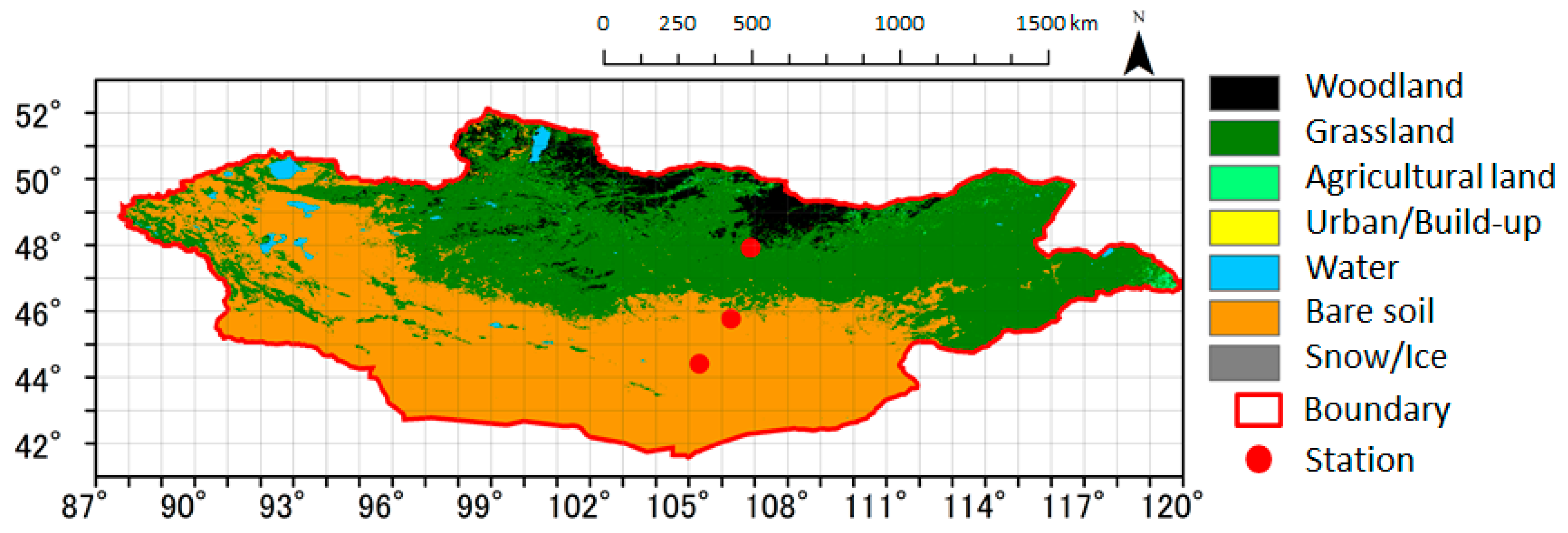
2.1. Target Area and Analysis Period
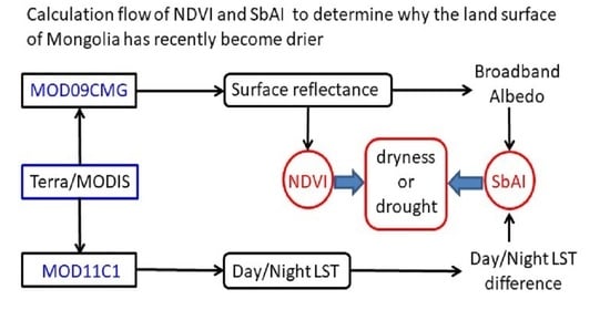
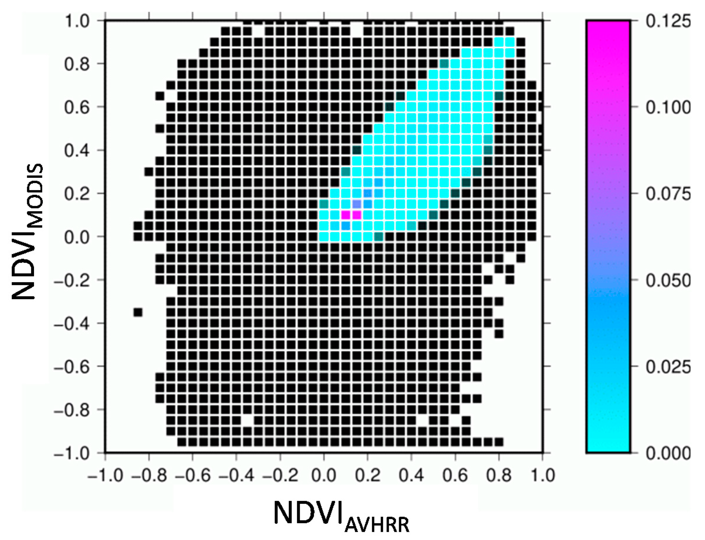
2.2. Data
2.3. Analytical Methods
3. Results
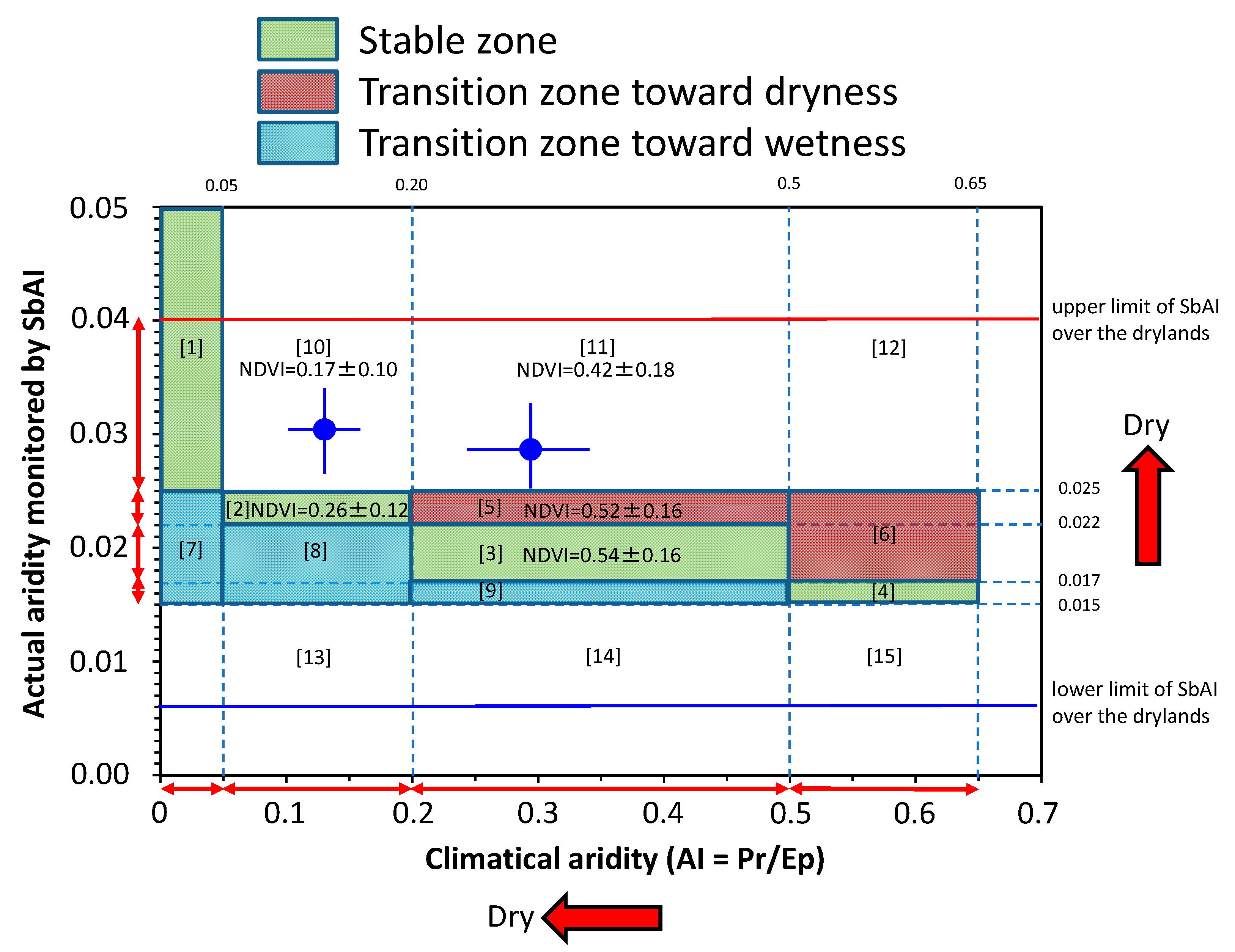
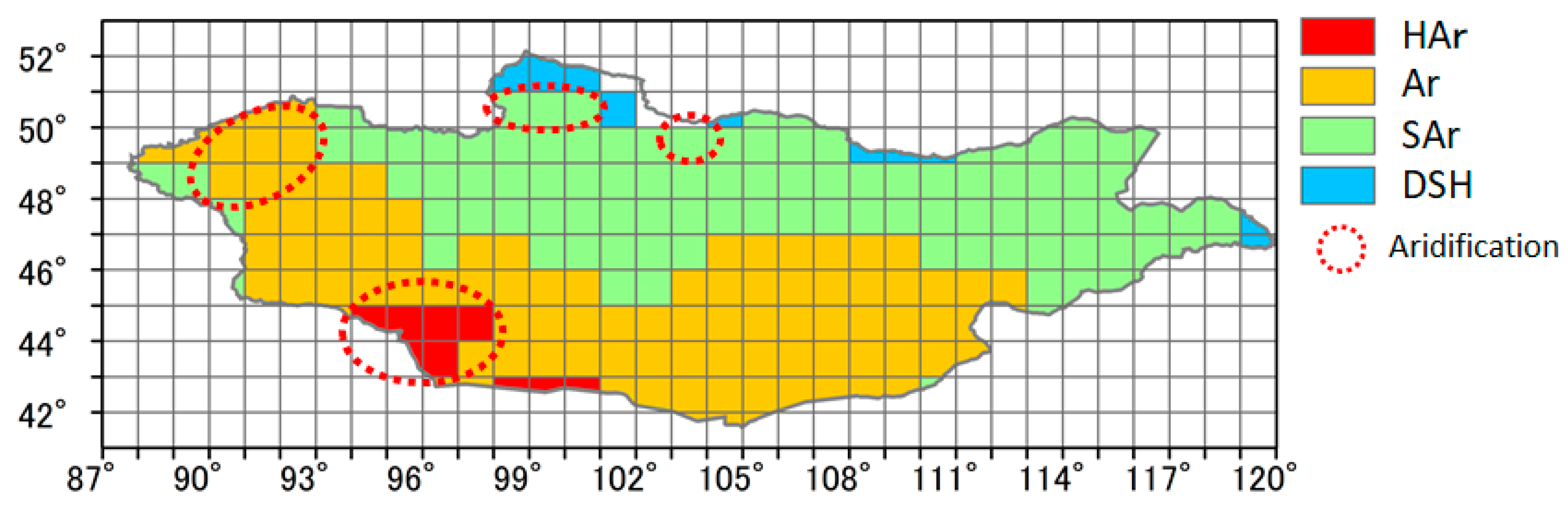
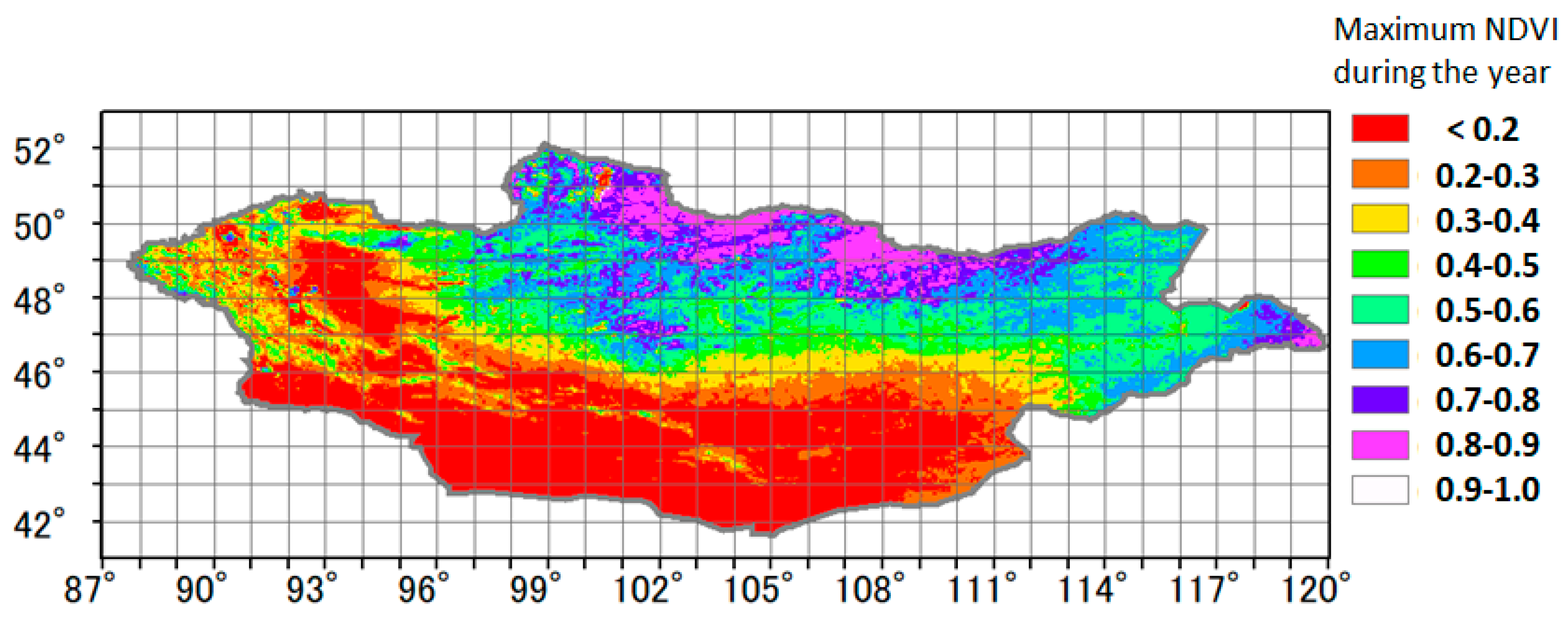
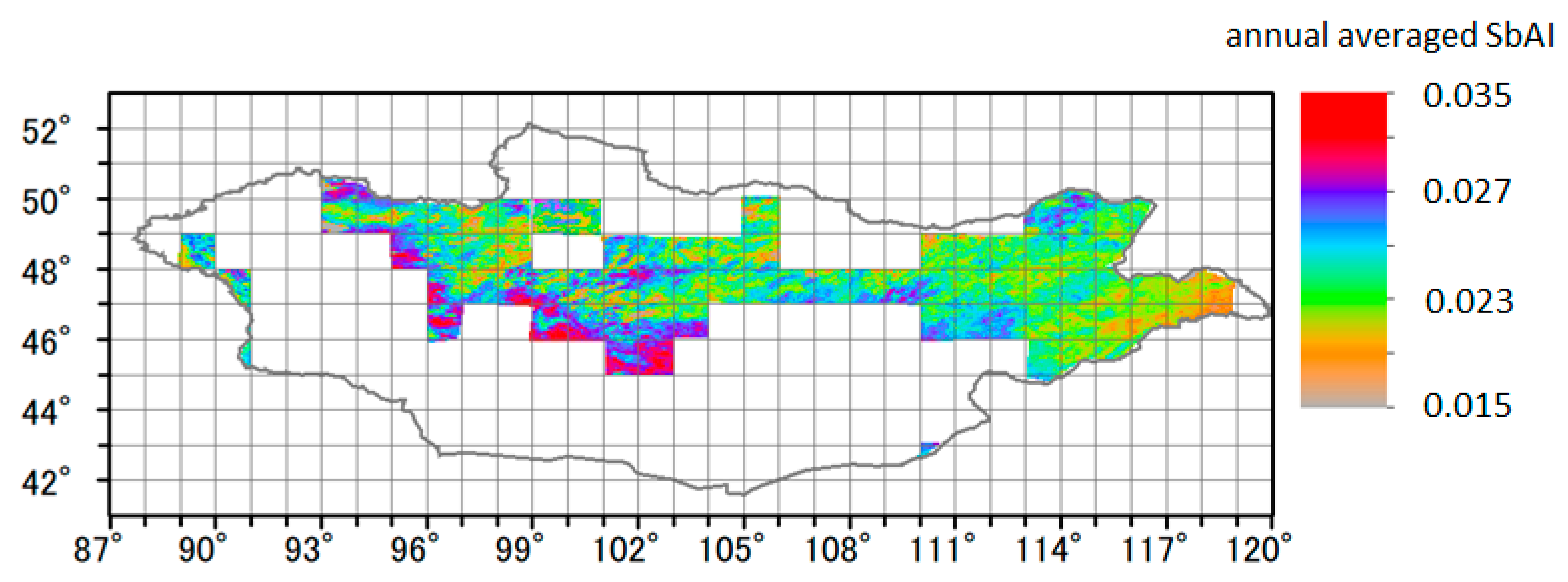
3.1. Distribution of Averaged AI in Mongolia from 2001 to 2013
- Zone 10 is climatically an Ar region. From 2001 to 2013, however, this zone had less vegetation and was similar to an HAr region.
- Zone 11 is climatically a SAr region. The amount of vegetation in the summer is moderate. However, the actual water retention throughout the year in zone 11 inferred from its SbAI value was similar to that of an HAr region.
3.2. Difference of Climatic Conditions Using AI
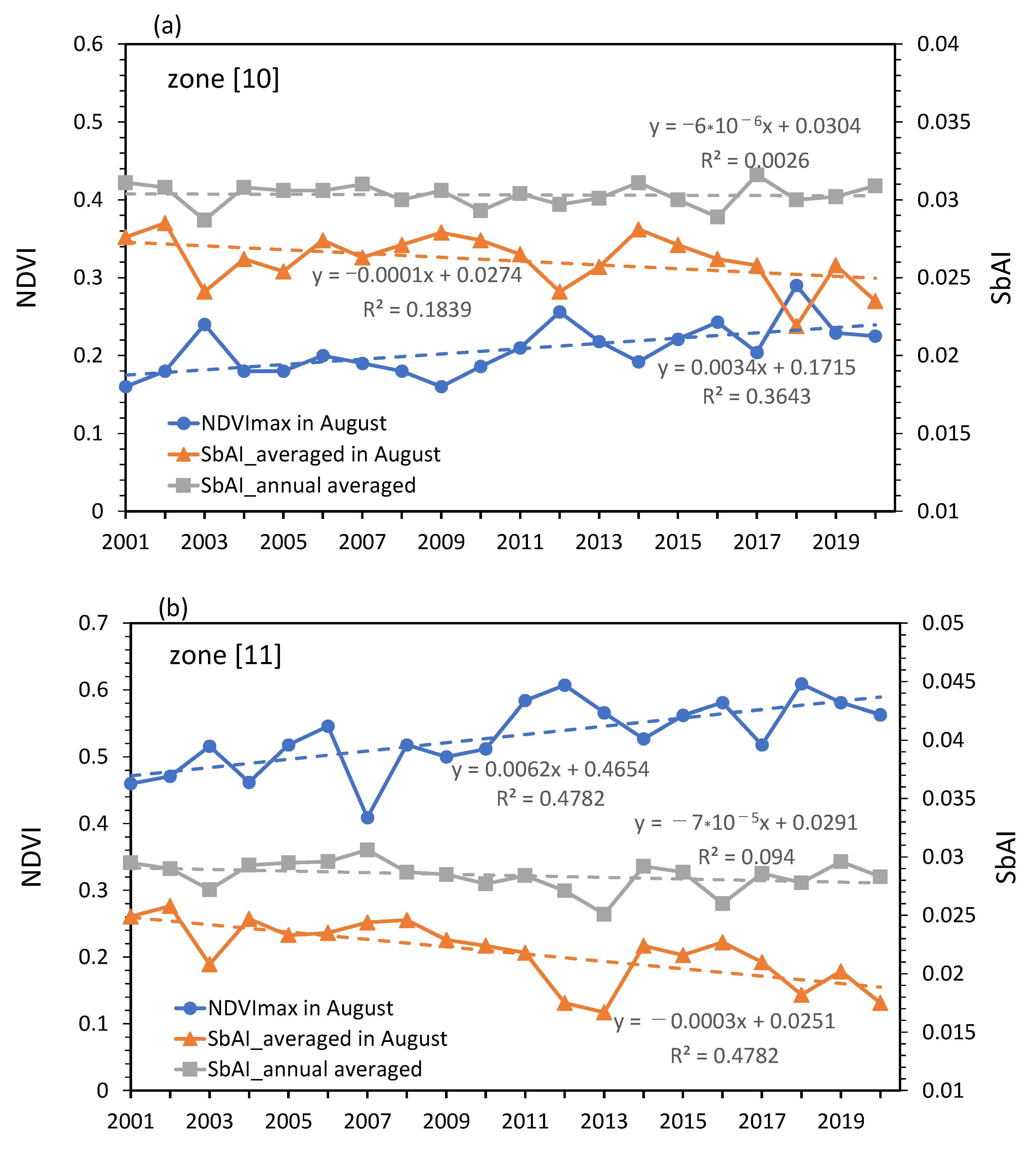
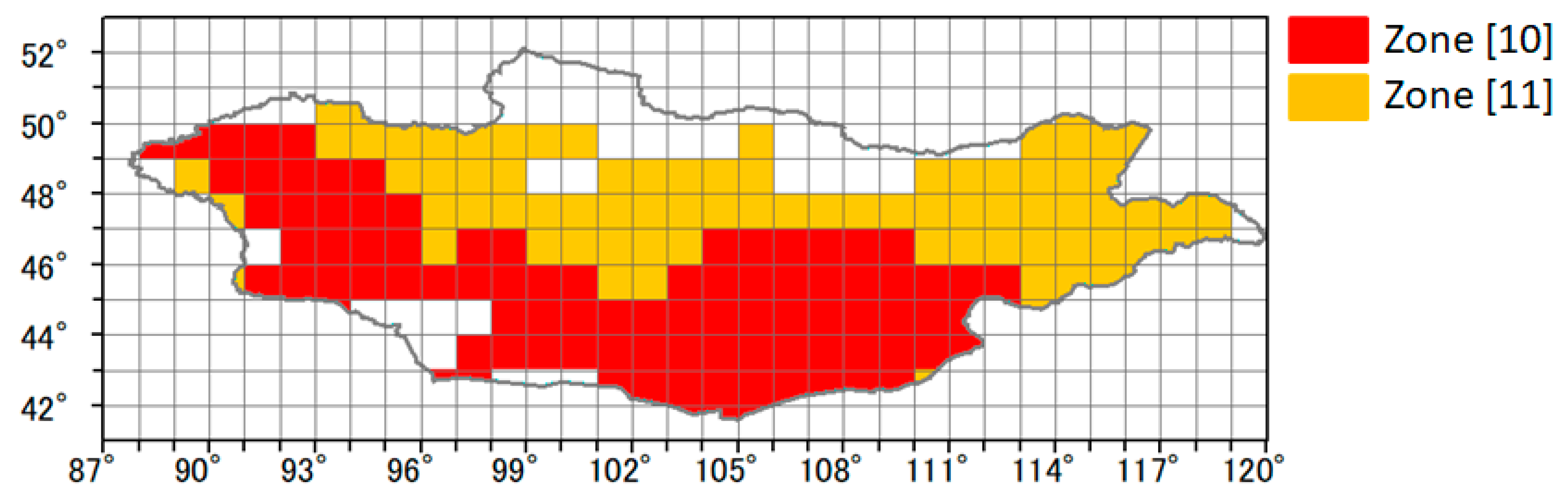
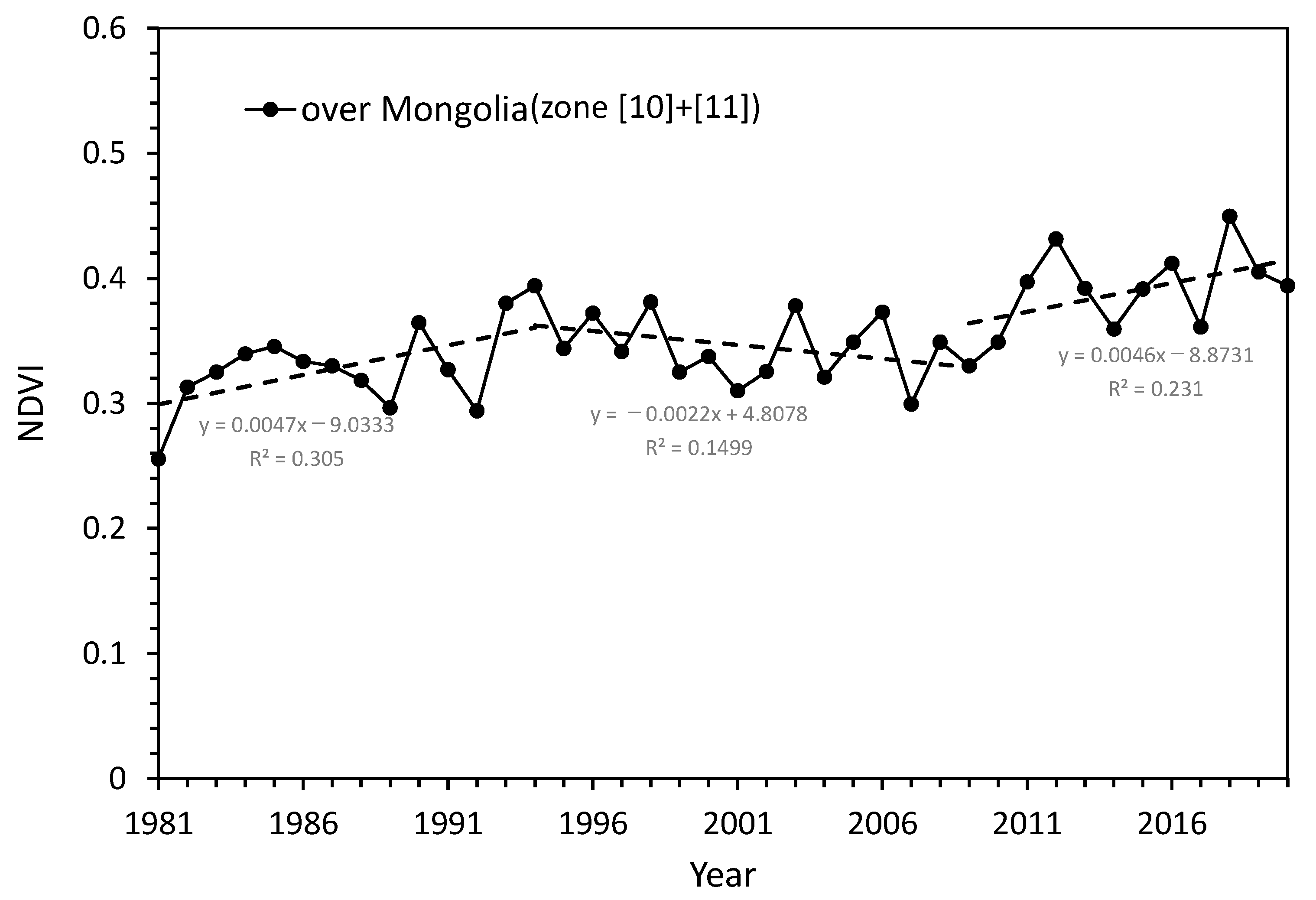
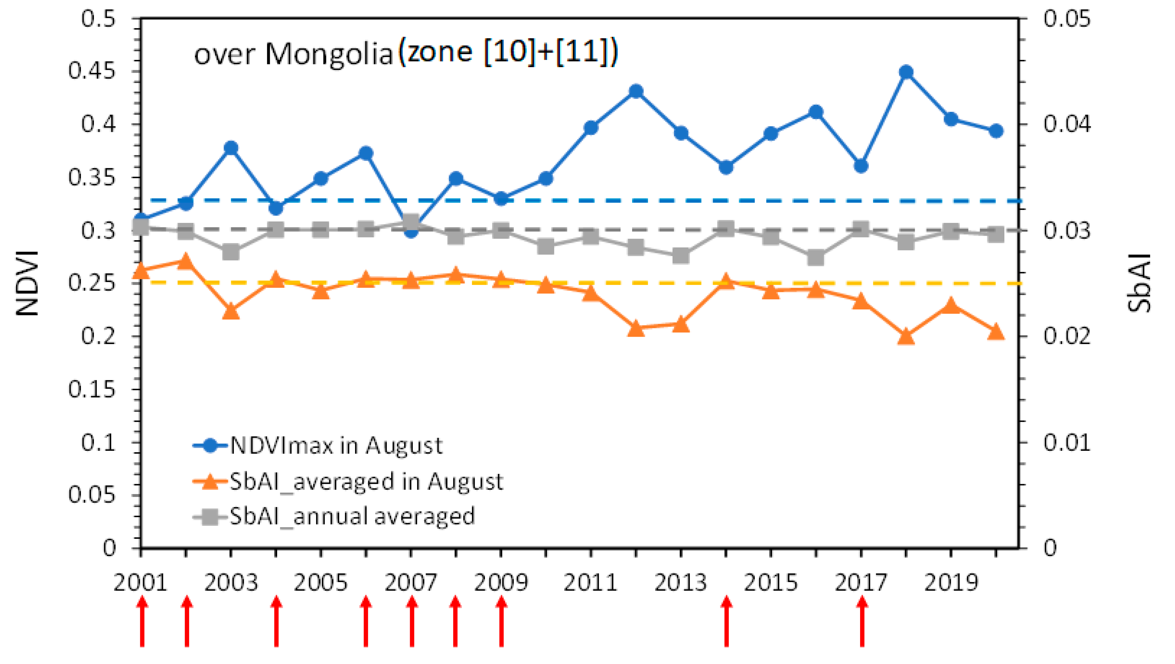
3.3. Trends of NDVImax and SbAI in Zones 10 and 11 during 2001–2020
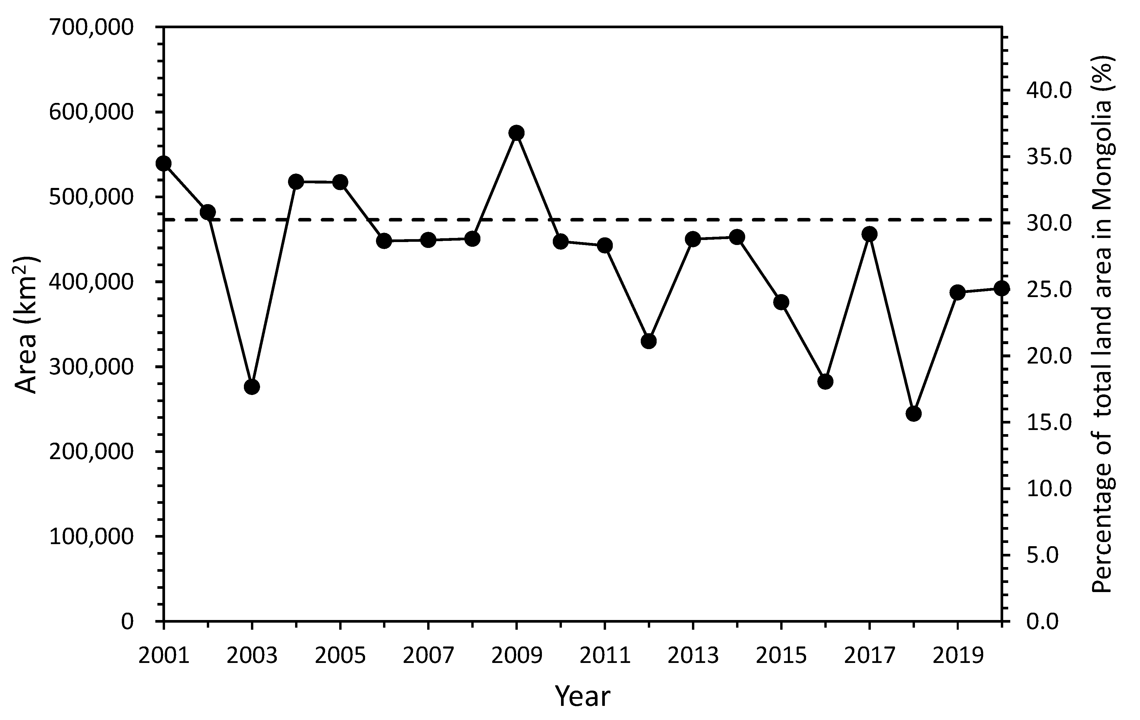
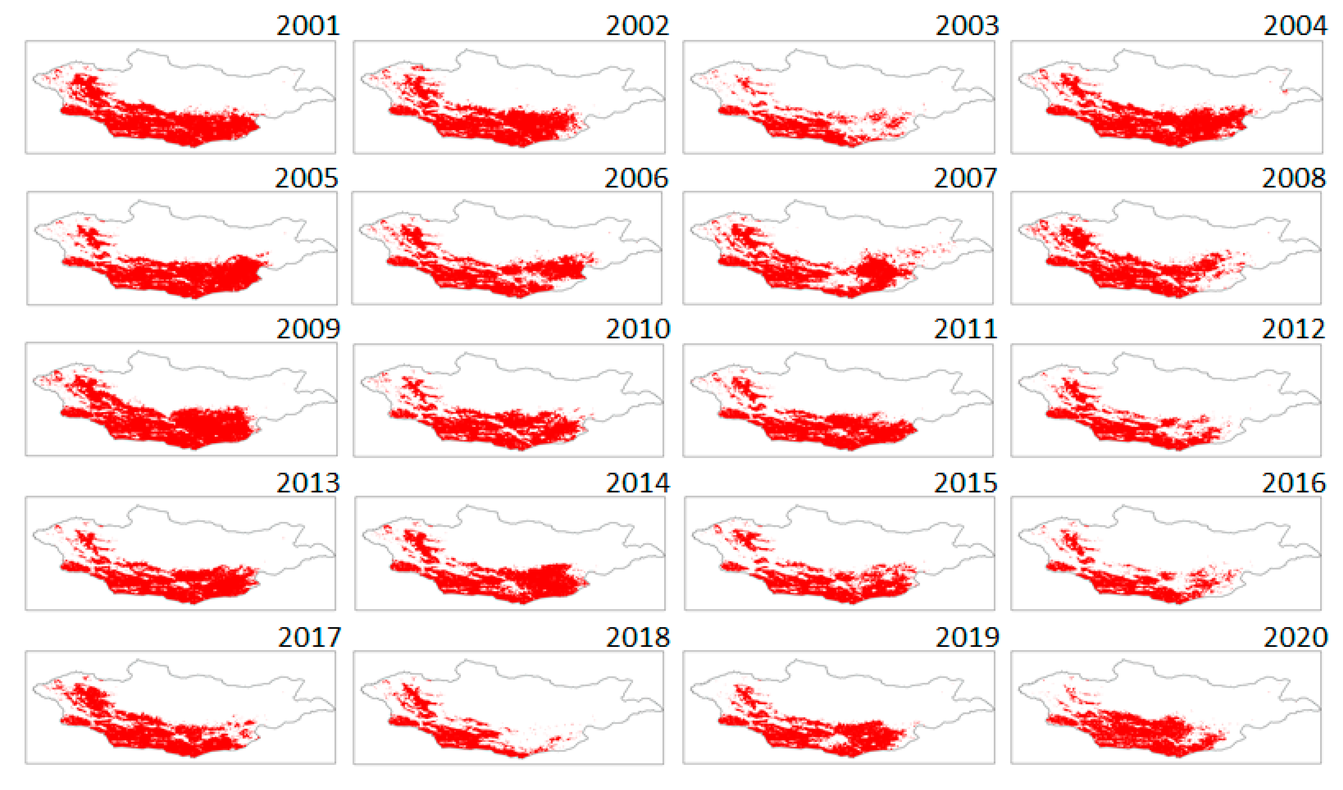
3.4. Detection of Drought Using SbAI
4. Discussion
- The NDVImax was small compared with the NDVImax values in other Ar and SAr regions.
- Did Mongolia become drier climatically? Although the AI distribution was almost unchanged compared with 1981–2010, annual rainfall during 1994–2010 was about 30 mm less than during 1982–1993. There is a possibility that the amount of vegetation was sensitive to a rainfall decrease of 30 mm. In fact, the NDVImax had been decreasing up to 2010 after peaking in 1994. The NDVImax was small even at its peak value of 0.39 in 1994, and it did not reach its averaged value of 0.4 in zones 2 and 3.
- The SbAI during the summer was relatively small (wet). However, the SbAI through the year was large (dry). In Mongolia, most of the annual rainfall occurs from April to July, and that rainfall is reflected by the NDVImax in August. After August, vegetation is dried or eaten by livestock, and the land surface wetness decreases (large SbAI). At the same time, there is less rainfall during seasons other than summer.
- Under the current conditions, the capacity of the land surface to retain water leads to a large SbAI because the concentrated summer rainfall affects the growth of vegetation.
5. Conclusions
Author Contributions
Funding
Institutional Review Board Statement
Informed Consent Statement
Acknowledgments
Conflicts of Interest
References
- IPCC. Climate Change 2013: The Physical Science Basis. In Contribution of Working Group I to the Fifth Assessment Report of the Intergovernmental Panel on Climate Change; Stocker, T.F.D., Qin, G.K., Plattner, M., Tignor, S.K., Allen, J., Boschung, A., Nauels, Y., Xia, V.B., Midgley, P.M., Eds.; Cambridge University Press: Cambridge, UK, 2013; p. 1535. [Google Scholar]
- Feng, S.; Fu, Q. Expansion of global drylands under a warming climate. Atmos. Chem. Phys. 2013, 13, 10081–10094. [Google Scholar] [CrossRef] [Green Version]
- Huang, J.; Li, Y.; Fu, C.; Chen, F.; Fu, Q.; Dai, A.; Shinoda, M.; Ma, Z.; Guo, W.; Li, Z.; et al. Dryland climate change: Recent progress and challenges. Rev. Geophys. 2017, 55, 719–778. [Google Scholar] [CrossRef]
- Koutroulis, A.G. Dryland changes under different levels of global warming. Sci. Total Environ. 2019, 655, 482–511. [Google Scholar] [CrossRef] [PubMed]
- White, R.P.; Nackoney, J. Drylands, People and Ecosystem Goods and Services; World Resources Institute: Washington, DC, USA, 2003; p. 40. [Google Scholar]
- Ministry of the Environment. Climate Change in Mongolia-Outputs from GCM. 2014. Available online: https://www.env.go.jp/earth/ondanka/pamph_gcm/gcm_mongolia_en.pdf (accessed on 17 February 2021).
- Shinoda, M.; Nandintsetseg, G.U. Climate Change and Hazards in Mongolia; Scientific Report in Nagoya University: Nagoya, Japan, 2015; p. 109. [Google Scholar]
- Liu, Y.Y.; Evans, J.P.; McCabe, M.F.; De Jeu, R.A.; van Dijk, A.I.; Dolman, A.J.; Saizen, I. Changing climate and overgrazing are decimating Mongolian steppes. PLoS ONE 2013, 8, e57599. [Google Scholar] [CrossRef] [PubMed] [Green Version]
- UNEP. World Atlas of Desertification; Arnold: London, UK, 1997; p. 182. [Google Scholar]
- Millennium Ecosystem Assessment (MA). Ecosystems and Human Well-Being; World Resources Institute: Washington, DC, USA, 2005; p. 25. [Google Scholar]
- Cherlet, M.; Hutchinson, C.; Reynolds, J.; Hill, J.; Sommer, S.; von Maltitz, G. (Eds.) World Atlas of Desertification; Publication Office of the European Union: Luxembourg, 2018; p. 248. [Google Scholar]
- Kimura, R.; Moriyama, M. Recent trends of annual aridity indices and classification of arid regions with satellite-based aridity indices. Remote Sens. Earth Syst. Sci. 2019, 2, 88–95. [Google Scholar] [CrossRef]
- Palmer, W. Meteorological Drought; US Weather Bureau: Washington, DC, USA, 1965; p. 59. [Google Scholar]
- Vicente-Serrano, S.M.; Begueria, S.; Lopez-Moreno, J.I. A multiscalar drought index sensitive to global warming: The standardized precipitation evapotranspiration. Index J. Clim. 2010, 23, 1696–1718. [Google Scholar] [CrossRef] [Green Version]
- Nandintsetseg, B.; Shinoda, M. Assessment of drought frequency, duration, and severity and its impact on pasture production in Mongolia. Nat. Hazards 2013, 66, 995–1008. [Google Scholar] [CrossRef]
- Hessl, A.E.; Anchukaitis, K.J.; Jelsema, C.; Cook, B.; Byambasuren, O.; Leland, C.; Nachin, B.; Pederson, N.; Tian, H.; Hayles, L.A. Past and future drought in Mongolia. Sci. Adv. 2018, 4, e1701832. [Google Scholar] [CrossRef] [Green Version]
- Kakinuma, K.; Yanagawa, A.; Sasaki, T.; Rao, M.P.; Kanae, S. Socio-ecological interactions in a changing climate: A review of the Mongolian pastoral system. Sustainability 2019, 11, 5883. [Google Scholar] [CrossRef] [Green Version]
- Tufaner, F.; Özbeyaz, A. Estimation and easy calculation of the Palmer drought severity index from the meteorological data by using the advanced machine learning algorithms. Environ. Monit. Assess. 2020, 192, 576. [Google Scholar] [CrossRef] [PubMed]
- Srivastava, A.; Sahoo, B.; Raghuwanshi, N.S.; Singh, R. Evaluation of variable-infiltration capacity model and MODIS-terra satellite-derived grid-scale evapotranspiration estimates in a River Basin with Tropical Monsoon-Type climatology. J. Irrig. Drain. Eng. 2017, 143, 04017028. [Google Scholar] [CrossRef] [Green Version]
- Pettorelli, N.; Vik, J.O.; Mysterud, A.; Gaillard, J.M.; Tucker, C.J.; Stenseth, N.C. Using the satellite-derived NDVI to assess ecological responses to environmental change. Trends Ecol. Evol. 2005, 20, 503–510. [Google Scholar] [CrossRef] [PubMed]
- Bayarjargal, Y.; Karnieli, A.; Bayasgalan, M.; Khudulmur, S.; Gandush, C.; Tucker, C.J. A comparative study of NOAA-AVHRR derived drought indices using change vector analysis. Remote Sens. Environ. 2006, 105, 9–22. [Google Scholar] [CrossRef]
- Chang, S.; Wu, B.; Yan, N.; Davdai, B.; Nasanbat, E. Suitability assessment of satellite-derived drought indices for Mongolian grassland. Remote Sens. 2017, 9, 650. [Google Scholar] [CrossRef] [Green Version]
- Nanzad, L.; Zhang, J.; Tuvdendorj, B.; Nabil, M.; Zhang, S.; Bai, Y. NDVI anomaly for drought monitoring and its correlation with climate factors over Mongolia from 2000 to 2016. J. Arid Environ. 2019, 164, 69–77. [Google Scholar] [CrossRef]
- Bakhtiari, M.; Boloorani, A.D.; Kakroodi, A.A.; Rangzan, K.; Mousivand, A. Land degradation modeling of dust storm sources using MODIS and meteorological time series data. J. Arid Environ. 2021, 190, 104507. [Google Scholar] [CrossRef]
- Jones, H.G.; Vaughan, R.A. Remote Sensing of Vegetation; Oxford University Press: New York, NY, USA, 2010; p. 353. [Google Scholar]
- Kimura, R.; Moriyama, M. Application of a satellite-based aridity index in dust source regions of northeast Asia. J. Arid Environ. 2014, 109, 31–38. [Google Scholar] [CrossRef]
- Kimura, R.; Moriyama, M. Determination by MODIS satellite-based methods of recent global trends in land surface aridity and degradation. J. Agric. Meteorol. 2019, 75, 153–159. [Google Scholar] [CrossRef] [Green Version]
- Kimura, R. Validation and application of the monitoring method for degraded land area based on a dust erodibility in eastern Asia. Int. J. Remote Sens. 2017, 38, 4553–4564. [Google Scholar] [CrossRef]
- Kimura, R. Global distribution of degraded land area based on dust erodibility determined from satellite data. Int. J. Remote Sens. 2018, 39, 5859–5871. [Google Scholar] [CrossRef]
- Kimura, R. Global detection of aridification or increasing wetness in arid regions from 2001 to 2013. Nat. Hazards 2020, 103, 2261–2276. [Google Scholar] [CrossRef]
- Kumari, N.; Saco, P.M.; Rodriguez, J.F.; Johnstone, S.A.; Srivastava, A.; Chun, K.P.; Yetemen, O. The grass is not always greener on the other side: Seasonal reversal of vegetation greenness in aspect-driven semiarid ecosystems. Geophys. Res. Lett. 2020, 47, e2020GL088918. [Google Scholar] [CrossRef]
- Nakano, T.; Shinoda, M. Spatial variability of photosynthetic production and ecosystem respiration on a hundred-kilometer scale within a Mongolian semiarid grassland. J. Agric. Meteorol. 2014, 70, 105–116. [Google Scholar] [CrossRef]
- ORNL DAAC. MODIS Collection 6 Land Product Subsets Web Service; ORNL DAAC: Oak Ridge, TN, USA, 2017. [Google Scholar] [CrossRef]
- Iwao, K.; Nishida, K.; Kinoshita, T.; Yamagata, Y. Validating land cover maps with Degree Confluence Project information. Geophys. Res. Lett. 2006, 33, L23404. [Google Scholar] [CrossRef]
- Gamo, M.; Shinoda, M.; Maeda, T. Classification of arid lands, including soil degradation and irrigated areas, based on vegetation and aridity indices. Int. J. Remote Sens. 2013, 34, 6701–6722. [Google Scholar] [CrossRef] [Green Version]
- Nandintsetseg, B.; Shinoda, M.; Kimura, R.; Ibaraki, Y. Relationship between soil moisture and vegetation activity in the Mongolian steppe. Sola 2010, 6, 29–32. [Google Scholar] [CrossRef] [Green Version]
- Batjargar, Z. Climate change and use of renewable energy in Mongolia. Erina Rep. Plus 2018, 145, 25–34. [Google Scholar]
- Kimura, R.; Moriyama, M. Use of a satellite-based aridity index to monitor decreased soil water content and grass growth in grasslands of north-east Asia. Remote Sens. 2020, 12, 3556. [Google Scholar] [CrossRef]
- UNEP. World Atlas of Desertification; Arnold: London, UK, 1992; p. 69. [Google Scholar]
- Fujita, N.; Kato, S.; Kusano, E.; Koda, R. Mongolia; Kyoto University Press: Kyoto, Japan, 2013; p. 685. (In Japanese) [Google Scholar]
- Spinoni, J.; Vogt, J.; Naumann, G.; Carrao, H.; Barbosa, P. Towards identifying areas at climatological risk of desertification using the KÖppen-Geiger classification and FAO aridity index. Int. J. Climatol. 2015, 35, 2210–2222. [Google Scholar] [CrossRef] [Green Version]
- Yu, W.; Wu, T.; Wang, W.; Li, R.; Wang, T.; Qin, Y.; Wang, W.; Zhu, X. Spatiotemporal changes of reference evapotranspiration in Mongolia during 1980–2006. Adv. Meteorol. 2016, 2016, 9586896. [Google Scholar] [CrossRef]
- Bao, G.; Qin, Z.; Bao, Y.; Zhou, Y.; Li, W.; Sanjjav, A. NDVI-based long term vegetation dynamics and its response to climatic change in the Mongolian plateau. Remote Sens. 2014, 6, 8337–8358. [Google Scholar] [CrossRef] [Green Version]
- Munkhtsetseg, E.; Kimura, R.; Wang, J.; Shinoda, M. Pasture yield response to precipitation and high temperature in Mongolia. J. Arid Environ. 2007, 70, 94–110. [Google Scholar] [CrossRef]
- Yu, W.; Li, Y.; Cao, Y.; Schillerberg, T. Drought assessment using GRACE terrestrial water storage deficit in Mongolia from 2002 to 2017. Water 2019, 11, 1301. [Google Scholar] [CrossRef] [Green Version]
- Fernández-Giménez, M.E.; Venable, N.H.; Angerer, J.; Fassnacht, S.R.; Reid, R.S.; Khishigbayar, J. Exploring linked ecological and cultural tipping points in Mongolia. Anthropocene 2017, 17, 46–69. [Google Scholar] [CrossRef]
- FAO. Special Report-FAO/WFP Crop and Livestock Assessment Mission to Mongolia; FAO/WFP: Rome, Italy, 2017; p. 43. [Google Scholar]
- Nandintsetseg, B.; Shinoda, M. Land surface memory effects on dust emission in a Mongolian temperate grassland. J. Geophys. Res. Biogeosciences 2015, 120, 414–427. [Google Scholar] [CrossRef]
- Templer, G.; Swift, J.; Payne, P. The changing significance of risk in the Mongolian pastoral economy. Nomadic Peoples 1993, 33, 105–122. [Google Scholar]


| Class | Range of SbAI | Range of AI |
|---|---|---|
| Hyper arid (HAr) | SbAI > 0.025 | AI < 0.05 |
| Arid (Ar) | 0.022 ≤ SbAI ≤ 0.025 | 0.05 ≤ AI < 0.2 |
| Semi-arid (SAr) | 0.017 ≤ SbAI < 0.022 | 0.2 ≤ AI < 0.5 |
| Dry sub-humid (DSH) | 0.015 ≤ SbAI < 0.017 | 0.5 ≤ AI < 0.65 |
Publisher’s Note: MDPI stays neutral with regard to jurisdictional claims in published maps and institutional affiliations. |
© 2021 by the authors. Licensee MDPI, Basel, Switzerland. This article is an open access article distributed under the terms and conditions of the Creative Commons Attribution (CC BY) license (https://creativecommons.org/licenses/by/4.0/).
Share and Cite
Kimura, R.; Moriyama, M. Use of A MODIS Satellite-Based Aridity Index to Monitor Drought Conditions in Mongolia from 2001 to 2013. Remote Sens. 2021, 13, 2561. https://doi.org/10.3390/rs13132561
Kimura R, Moriyama M. Use of A MODIS Satellite-Based Aridity Index to Monitor Drought Conditions in Mongolia from 2001 to 2013. Remote Sensing. 2021; 13(13):2561. https://doi.org/10.3390/rs13132561
Chicago/Turabian StyleKimura, Reiji, and Masao Moriyama. 2021. "Use of A MODIS Satellite-Based Aridity Index to Monitor Drought Conditions in Mongolia from 2001 to 2013" Remote Sensing 13, no. 13: 2561. https://doi.org/10.3390/rs13132561
APA StyleKimura, R., & Moriyama, M. (2021). Use of A MODIS Satellite-Based Aridity Index to Monitor Drought Conditions in Mongolia from 2001 to 2013. Remote Sensing, 13(13), 2561. https://doi.org/10.3390/rs13132561