
A Large Old Landslide in Sichuan Province, China: Surface Displacement Monitoring and Potential Instability Assessment


Abstract
:
1. Introduction
2. Study Area and Description of the Old Landslide
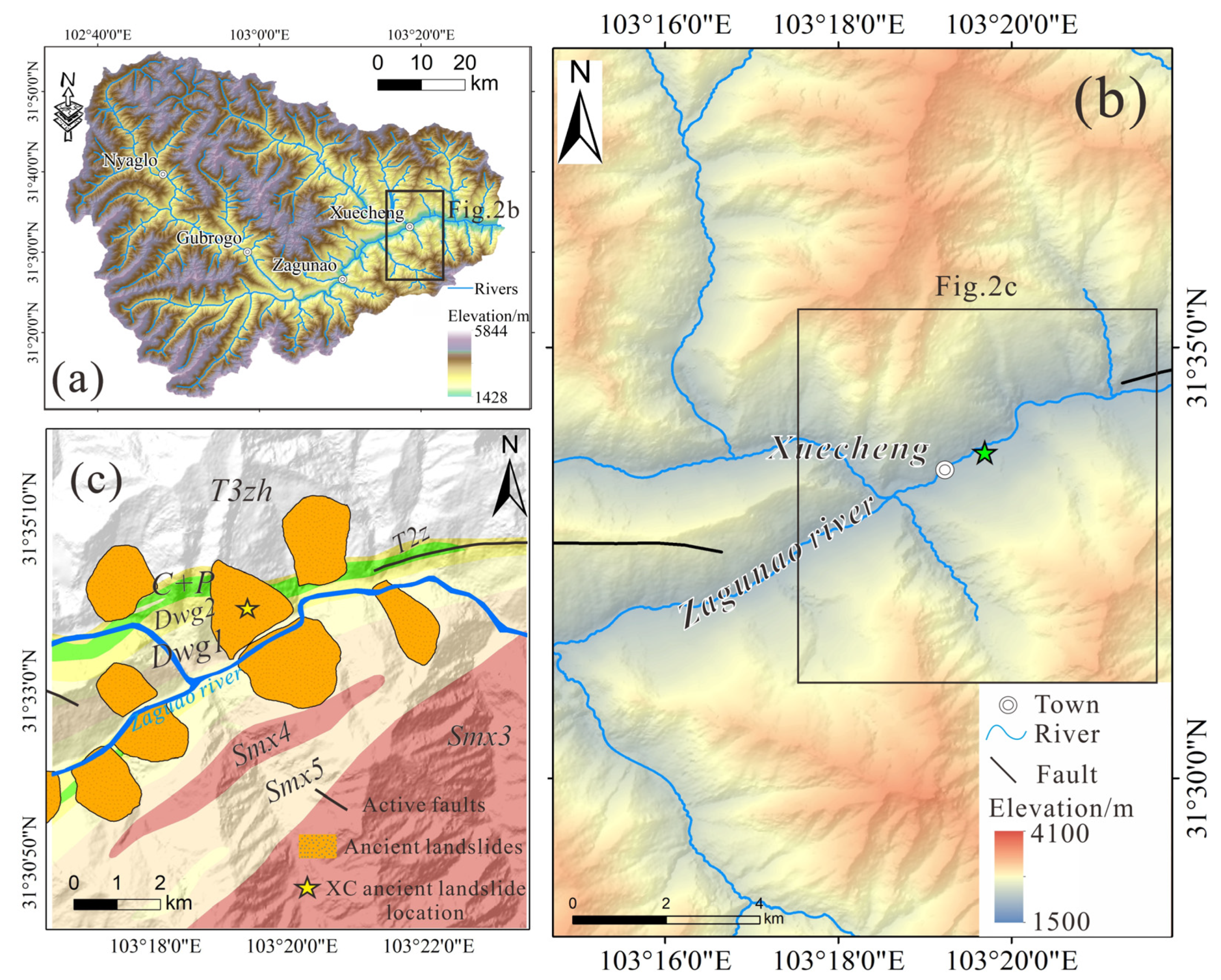
2.1. Study Area
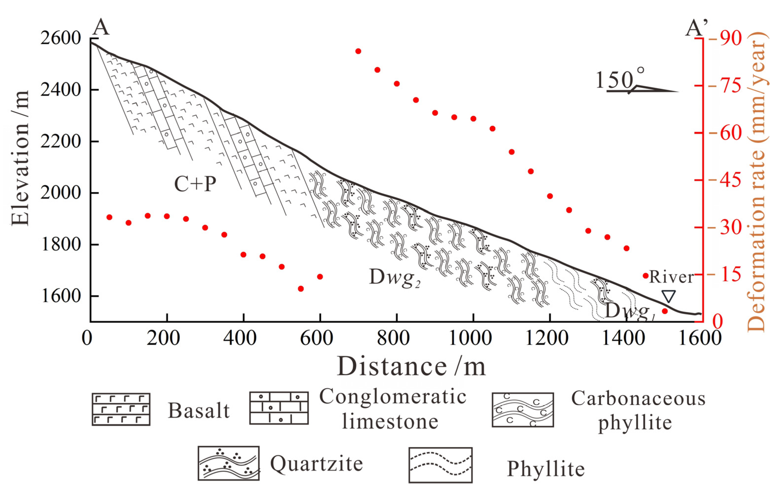
2.2. Landslide Characteristics
3. Data
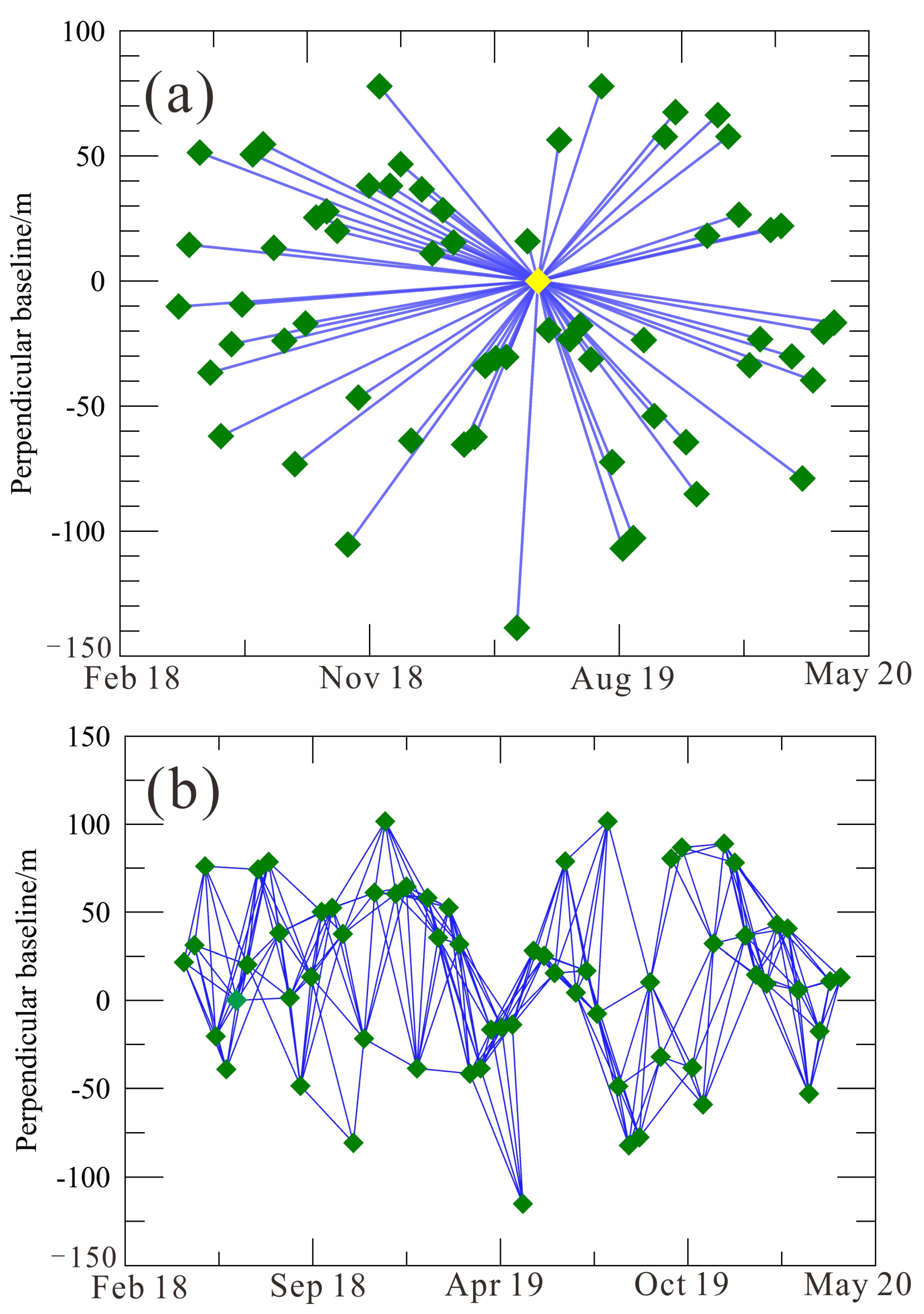
3.1. SAR Datasets
3.2. UAV Data
4. Methodology
4.1. MT-InSAR Processing
4.2. MassMov2D Model
5. Results
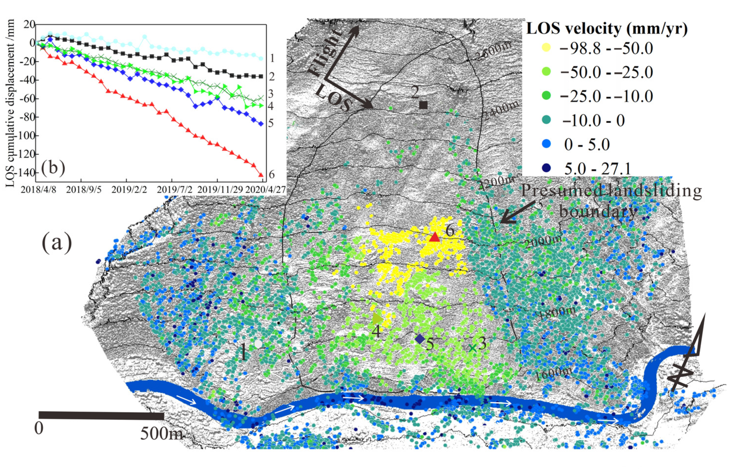
5.1. InSAR Time Series
5.2. Prediction of Potential Unstable Rock Mass
6. Discussion
6.1. Possible Triggering Factors of Old Landslides
6.2. Impacts of Potential Failure
6.3. Application Prospects for InSAR and UAV Techniques
7. Conclusions
- (1)
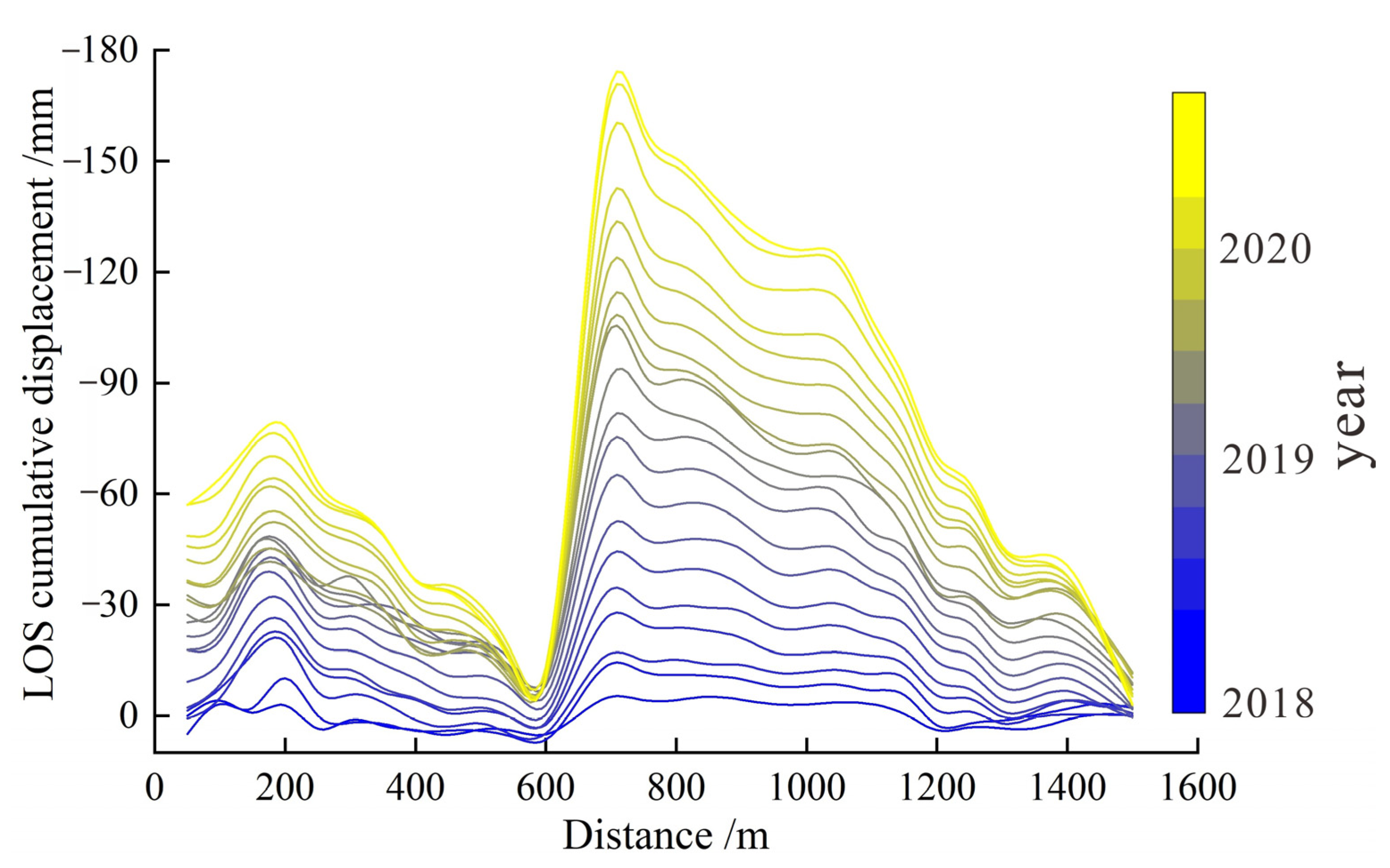
- Both InSAR techniques can provide useful information about the landslide, and SBAS can produce smoother and more abundant displacement time series data. From April 2018 to April 2020, the deformation in the middle of the slope was the largest, and the cumulative displacement was between −120 and −160 mm, with an average LOS deformation rate of −70 mm/year.
- (2)
- A strong correlation exists between the LOS deformation rate and rainfall. In rainy seasons, particularly from May to July, the deformation rate was relatively high. From May to July in 2018, the deformation rate reached 1 mm/day.
- (3)
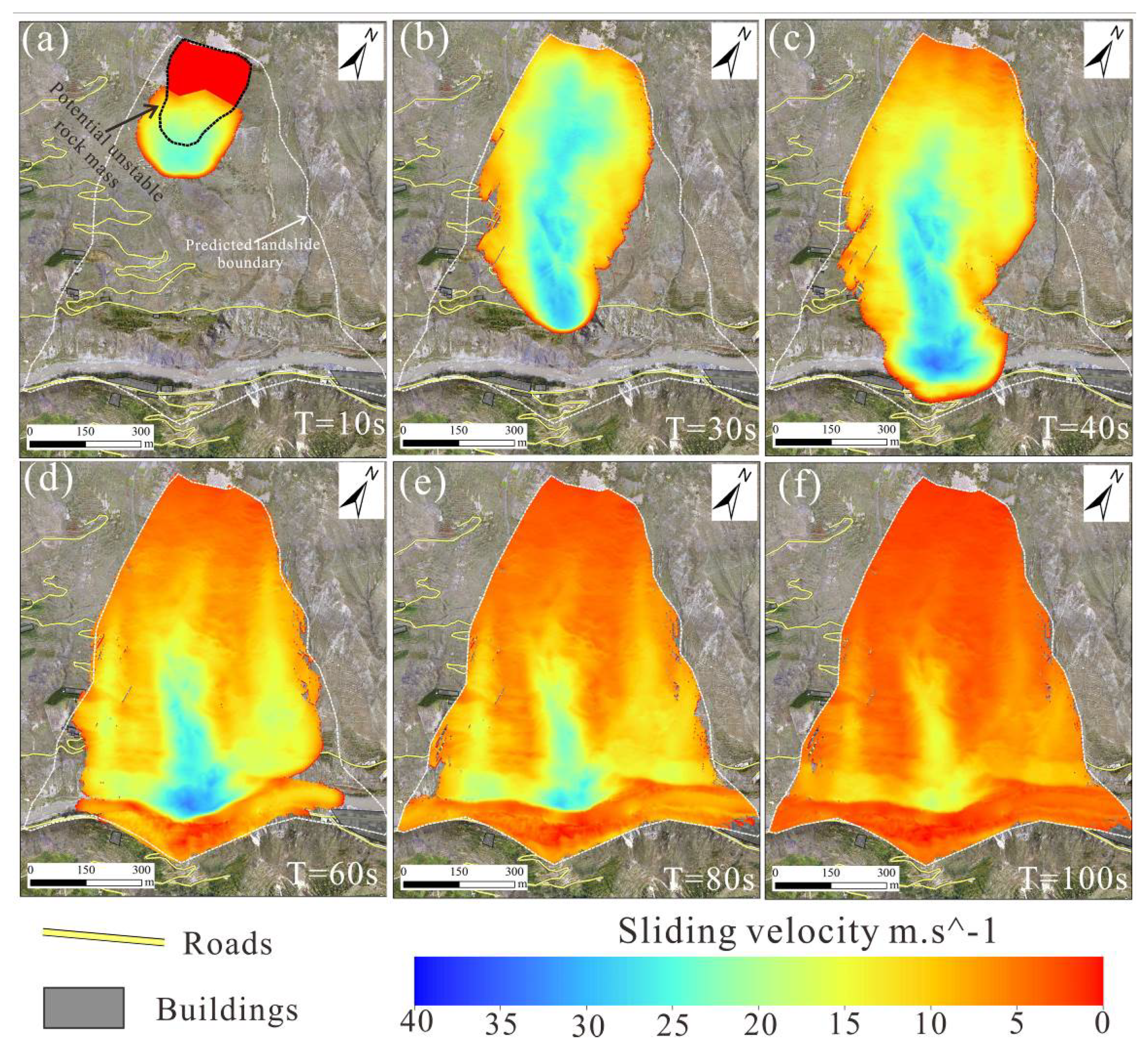
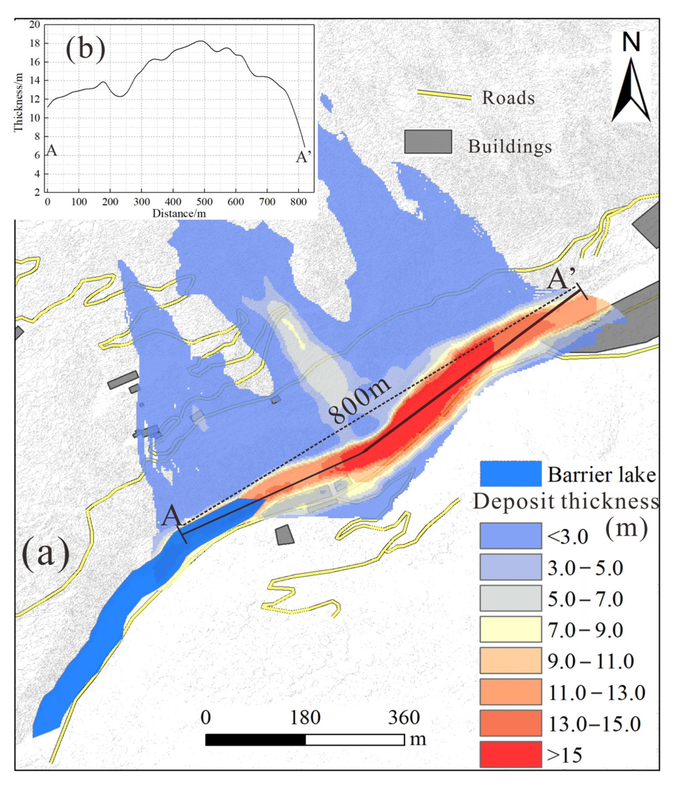
- The whole sliding process of the hypothetical collapse body lasts about 100 s, and leads to the collapse and formation of a barrier dam at the Zagunao river. Constrained by the narrow valley, the occurrence of a landslide in this area may cause the natural disaster chain of “landslide–barrier lake–flooding”, thus posing a significant threat to upstream and downstream areas. As a result, this possible hazard should receive greater attention.
Supplementary Materials
Author Contributions
Funding
Data Availability Statement
Acknowledgments
Conflicts of Interest
References
- Mateos, R.M.; Azañón, J.M.; Roldán, F.J.; Notti, D.; Pérez-Peña, V.; Galve, J.P.; Pérez-García, J.L.; Colomo, C.M.; Gómez-López, J.M.; Montserrat, O.; et al. The combined use of PSInSAR and UAV photogrammetry techniques for the analysis of the kinematics of a coastal landslide affecting an urban area (SE Spain). Landslides 2017, 14, 743–754. [Google Scholar] [CrossRef]
- Schlögel, R.; Doubre, C.; Malet, J.-P.; Masson, F. Landslide deformation monitoring with ALOS/PALSAR imagery: A D-InSAR geomorphological interpretation method. Geomorphology 2015, 231, 314–330. [Google Scholar] [CrossRef]
- Hu, X.; Bürgmann, R.; Lu, Z.; Handwerger, A.L.; Wang, T.; Miao, R. Mobility, thickness, and hydraulic diffusivity of the slow-moving monroe landslide in California revealed by L-Band satellite radar interferometry. J. Geophys. Res. Solid Earth 2019, 124, 7504–7518. [Google Scholar] [CrossRef] [Green Version]
- Yang, Z.; Wei, J.; Deng, J.; Gao, Y.; Zhao, S.; He, Z. Mapping Outburst Floods Using a Collaborative Learning Method Based on Temporally Dense Optical and SAR Data: A Case Study with the Baige Landslide Dam on the Jinsha River, Tibet. Remote Sens. 2021, 13, 2205. [Google Scholar] [CrossRef]
- Fobert, M.-A.; Singhroy, V.; Spray, J.G. InSAR Monitoring of Landslide Activity in Dominica. Remote Sens. 2021, 13, 815. [Google Scholar] [CrossRef]
- Lin, S.-Y.; Lin, C.-W.; van Gasselt, S. Processing Framework for Landslide Detection Based on Synthetic Aperture Radar (SAR) Intensity-Image Analysis. Remote Sens. 2021, 13, 644. [Google Scholar] [CrossRef]
- Devoto, S.; Macovaz, V.; Mantovani, M.; Soldati, M.; Furlani, S. Advantages of Using UAV Digital Photogrammetry in the Study of Slow-Moving Coastal Landslides. Remote Sens. 2020, 12, 3566. [Google Scholar] [CrossRef]
- Wasowski, J.; Bovenga, F. Investigating landslides and unstable slopes with satellite Multi Temporal Interferometry: Current issues and future perspectives. Eng. Geol. 2014, 174, 103–138. [Google Scholar] [CrossRef]
- Refice, A.; Spalluto, L.; Bovenga, F.; Fiore, A.; Miccoli, M.N.; Muzzicato, P.; Nitti, D.O.; Nutricato, R.; Pasquariello, G. Integration of persistent scatterer interferometry and ground data for landslide monitoring: The Pianello landslide (Bovino, Southern Italy). Landslides 2019, 16, 447–468. [Google Scholar] [CrossRef] [Green Version]
- Dong, J.; Liao, M.; Xu, Q.; Zhang, L.; Tang, M.; Gong, J. Detection and displacement characterization of landslides using multi-temporal satellite SAR interferometry: A case study of Danba County in the Dadu River Basin. Eng. Geol. 2018, 240, 95–109. [Google Scholar] [CrossRef]
- Bianchini, S.; Cigna, F.; Righini, G.; Proietti, C.; Casagli, N. Landslide hotspot mapping by means of persistent scatterer interferometry. Environ. Earth Sci. 2012, 67, 1155–1172. [Google Scholar] [CrossRef]
- Zhang, Y.; Meng, X.; Chen, G.; Qiao, L.; Zeng, R.; Chang, J. Detection of geohazards in the Bailong River Basin using synthetic aperture radar interferometry. Landslides 2016, 13, 1273–1284. [Google Scholar] [CrossRef]
- Zhang, Y.; Meng, X.M.; Dijkstra, T.A.; Jordan, C.J.; Chen, G.; Zeng, R.Q.; Novellino, A. Forecasting the magnitude of potential landslides based on InSAR techniques. Remote Sens. Environ. 2020, 241, 111738. [Google Scholar] [CrossRef]
- Jia, H.; Zhang, H.; Liu, L.; Liu, G. Landslide deformation monitoring by adaptive distributed scatterer interferometric synthetic aperture radar. Remote Sens. 2019, 11, 2273. [Google Scholar] [CrossRef] [Green Version]
- Wang, J.; Wang, C.; Xie, C.; Zhang, H.; Tang, Y.; Zhang, Z.; Shen, C. Monitoring of large-scale landslides in Zongling, Guizhou, China, with improved distributed scatterer interferometric SAR time series methods. Landslides 2020, 17, 1777–1795. [Google Scholar] [CrossRef]
- Tofani, V.; Raspini, F.; Catani, F.; Casagli, N. Persistent Scatterer Interferometry (PSI) Technique for Landslide Characterization and Monitoring. Remote Sens. 2013, 5, 1045–1065. [Google Scholar] [CrossRef] [Green Version]
- Liu, X.; Zhao, C.; Zhang, Q.; Yang, C.; Zhu, W. Heifangtai loess landslide type and failure mode analysis with ascending and descending Spot-mode TerraSAR-X datasets. Landslides 2020, 17, 205–215. [Google Scholar] [CrossRef] [Green Version]
- Nishiguchi, T.; Tsuchiya, S.; Imaizumi, F. Detection and accuracy of landslide movement by InSAR analysis using PALSAR-2 data. Landslides 2017, 14, 1483–1490. [Google Scholar] [CrossRef]
- McDougall, S. Landslide runout analysis-current practice and challenges. Can. Geotech. J. 2016, 54. [Google Scholar] [CrossRef] [Green Version]
- Ouyang, C.; An, H.; Zhou, S.; Wang, Z.; Su, P.; Wang, D.; Cheng, D.; She, J. Insights from the failure and dynamic characteristics of two sequential landslides at Baige village along the Jinsha River, China. Landslides 2019, 16, 1397–1414. [Google Scholar] [CrossRef]
- Scaringi, G.; Fan, X.; Xu, Q.; Liu, C.; Ouyang, C.; Domènech, G.; Yang, F.; Dai, L. Some considerations on the use of numerical methods to simulate past landslides and possible new failures: The case of the recent Xinmo landslide (Sichuan, China). Landslides 2018, 15, 1359–1375. [Google Scholar] [CrossRef]
- Molinari, M.E.; Cannata, M.; Meisina, C. r.massmov: An open-source landslide model for dynamic early warning systems. Nat. Hazards 2014, 70, 1153–1179. [Google Scholar] [CrossRef]
- Yin, Y.; Zheng, W.; Li, X.; Sun, P.; Li, B. Catastrophic landslides associated with the M8.0 Wenchuan earthquake. Bull. Eng. Geol. Environ. 2011, 70, 15–32. [Google Scholar] [CrossRef]
- Qu, T.; Lu, P.; Liu, C.; Wu, H.; Shao, X.; Wan, H.; Li, N.; Li, R. Hybrid-SAR Technique: Joint analysis using phase-based and amplitude-based methods for the Xishancun giant landslide monitoring. Remote Sens. 2016, 8, 874. [Google Scholar] [CrossRef] [Green Version]
- He, C.; Ju, N.; Xie, M. Application of InSAR Technology in Early recognition of geohazards. J. Xihua Univ. (Nat. Sci. Ed.) 2019, 38, 32–39. [Google Scholar] [CrossRef]
- Deng, Q.D. Chinese Active Tectonic Map; Seismological Press: Beijing, China, 2007. [Google Scholar]
- Huang, J. Analysis of Development Law and Genetic Mechanism of the Collapse in Xuecheng Area, Zagunao River; Chengdu University of Technology: Chengdu, China, 2016. [Google Scholar]
- Hu, S.; Qiu, H.; Wang, X.; Gao, Y.; Wang, N.; Wu, J.; Yang, D.; Cao, M. Acquiring high-resolution topography and performing spatial analysis of loess landslides by using low-cost UAVs. Landslides 2018, 15, 1–20. [Google Scholar] [CrossRef]
- Mitasova, H.; Mitas, L.; Brown, W.; Gerdes, D.; Kosinovsky, I.; Baker, T. Modelling Spatially and Temporally Distributed Phenomena: New Methods and Tools for GRASS GIS. Int. J. Geogr. Inf. Syst. 1995, 9, 433–446. [Google Scholar] [CrossRef]
- ESA. European Space Agency Missions: SENTINEL-1. Available online: https://sentinel.esa.int/web/sentinel/missions/sentinel-1 (accessed on 10 April 2021).
- Farkas, P.; Hevér, R.; Grenerczy, G. Geodetic integration of Sentinel-1A IW data using PSInSAR in Hungary. In Proceedings of the EGU General Assembly Conference, Vienna, Austria, 12–17 April 2015; p. 13483. [Google Scholar]
- Intrieri, E.; Raspini, F.; Fumagalli, A.; Lu, P.; Del Conte, S.; Farina, P.; Allievi, J.; Ferretti, A.; Casagli, N. The Maoxian landslide as seen from space: Detecting precursors of failure with Sentinel-1 data. Landslides 2018, 15, 123–133. [Google Scholar] [CrossRef] [Green Version]
- Lian, X.; Liu, X.; Ge, L.; Hu, H.; Du, Z.; Wu, Y. Time-series unmanned aerial vehicle photogrammetry monitoring method without ground control points to measure mining subsidence. J. Appl. Remote Sens. 2021, 15. [Google Scholar] [CrossRef]
- Hooper, A.; Bekaert, D.; Spaans, K.; Arikan, M. Recent advances in SAR interferometry time series analysis for measuring crustal deformation. Tectonophysics 2012, 514. [Google Scholar] [CrossRef]
- Ferretti, A.; Prati, C.; Rocca, F. Nonlinear subsidence rate estimation using permanent scatters in differential SAR interferometry. IEEE Trans. Geosci. Remote Sens. 2000, 38, 2202–2212. [Google Scholar] [CrossRef] [Green Version]
- Ferretti, A.; Prati, C.; Rocca, F. Permanent scatterers in SAR interferometry. IEEE Trans. Geosci. Remote Sens. 2001, 39, 8–20. [Google Scholar] [CrossRef]
- Hooper, A.; Zebker, H.; Segall, P.; Kampes, B. A new method for measuring deformation on volcanoes and other natural terrains using InSAR persistent scatterers. Geophys. Res. Lett. 2004, 31. [Google Scholar] [CrossRef]
- Berardino, P.; Fornaro, G.; Lanari, R.; Sansosti, E. A new algorithm for surface deformation monitoring based on small baseline differential SAR interferograms. IEEE Trans. Geosci. Remote Sens. 2002, 40, 2375–2383. [Google Scholar] [CrossRef] [Green Version]
- Simonetto, E.; Follin, J.-M. Overview on Interferometric SAR Software and a Comparison between DORIS and SARscape Processing. In Geospatial Free and Open Source Software in the 21st Century: Proceedings of the first Open Source Geospatial Research Symposium, OGRS 2009; Springer: Berlin/Heidelberg, Germany, 2012; pp. 107–122. [Google Scholar]
- Dini, B.; Manconi, A.; Loew, S.; Chophel, J. The Punatsangchhu-I dam landslide illuminated by InSAR multitemporal analyses. Sci. Rep. 2020, 10, 8304. [Google Scholar] [CrossRef] [PubMed]
- Chen, C.W.; Zebker, H.A. Phase unwrapping for large SAR Interferograms: Statistical segmentation and generalized network models. IEEE Trans. Geosci. Remote Sens. 2002, 40, 1709–1719. [Google Scholar] [CrossRef] [Green Version]
- Goldstein, R.M.; Werner, C.L. Radar interferogram filtering for geophysical applications. Geophys. Res. Lett. 1998, 25, 4035–4038. [Google Scholar] [CrossRef] [Green Version]
- Zhang, Y.; Liu, Y.; Jin, M.; Jing, Y.; Liu, Y.; Liu, Y.; Sun, W.; Wei, J.; Chen, Y. Monitoring Land Subsidence in Wuhan City (China) using the SBAS-InSAR Method with Radarsat-2 Imagery Data. Sensors 2019, 19, 743. [Google Scholar] [CrossRef] [Green Version]
- Savage, S.; Hutter, C. The motion of a finite mass of granular material down a rough incline. J. Fluid Mech. 1989, 199, 177–215. [Google Scholar] [CrossRef]
- Iverson, R.M.; Denlinger, R.P. Flow of variably fluidized granular masses across three-dimensional terrain: 1. Coulomb mixture theory. J. Geophys. Res. Solid Earth 2001, 106, 537–552. [Google Scholar] [CrossRef]
- Beguería, S.; Asch, T.W.J.; Malet, J.P.; Grondahl, S. A GIS-based numerical model for simulating the kinematics of mud and debris flows over complex terrain. Nat. Hazards Earth Syst. Sci. 2009, 9. [Google Scholar] [CrossRef] [Green Version]
- Molinari, M.E.; Cannata, M.; Begueria, S.; Ambrosi, C. GIS-based Calibration of MassMov2D. Trans. GIS 2012, 16, 215–231. [Google Scholar] [CrossRef] [Green Version]
- Chen, X.; Tessari, G.; Fabris, M.; Achilli, V.; Floris, M. Comparison Between PS and SBAS InSAR Techniques in Monitoring Shallow Landslides. In Understanding and Reducing Landslide Disaster Risk; Volume 3 Monitoring and Early Warning; Springer International Publishing: Cham, Switzerland, 2021; pp. 155–161. [Google Scholar]
- Xu, C.; Xu, X.; Shen, L.; Yao, Q.; Tan, X.; Kang, W.; Ma, S.; Wu, X.; Cai, J.; Gao, M. Optimized volume models of earthquake-triggered landslides. Sci. Rep. 2016, 6, 29797. [Google Scholar] [CrossRef]
- Zahra, T. Quantifying Uncertainties in Landslide Runout Modelling; IIRS-NRSC: Dehradun, India, 2010. [Google Scholar]
- Hungr, O.; Evans, S. Rock avalanche runout prediction using a dynamic model. In Proceedings of the 7th International Symposium on Landslides, Trondheim, Norway, 17–21 June 1996; Volume 1, pp. 233–238. [Google Scholar]
- Shugar, D.; Jacquemart, M.; Shean, D.; Bhushan, S.; Upadhyay, K.; Sattar, A.; Schwanghart, W.; McBride, S.; Vries, M.; Mergili, M.; et al. A massive rock and ice avalanche caused the 2021 disaster at Chamoli, Indian Himalaya. Science 2021, eabh4455. [Google Scholar] [CrossRef]
- Liu, W.; He, S. Dynamic simulation of a mountain disaster chain: Landslides, barrier lakes, and outburst floods. Nat. Hazards 2018, 90, 1–19. [Google Scholar] [CrossRef] [Green Version]
- Fan, X.; Yang, F.; Siva Subramanian, S.; Feng, Z.; Mavrouli, O.; Peng, M.; Ouyang, C.; Jansen, J.; Huang, R. Prediction of a multi-hazard chain by an integrated numerical simulation approach: The Baige landslide, Jinsha River, China. Landslides 2020, 17, 147–164. [Google Scholar] [CrossRef]
- Zhuang, Y.; Yin, Y.; Xing, A.; Jin, K. Combined numerical investigation of the Yigong rock slide-debris avalanche and subsequent dam-break flood propagation in Tibet, China. Landslides 2020, 17, 2217–2229. [Google Scholar] [CrossRef]
- Xie, M.; Zhao, W.; Ju, N.; He, C.; Huang, H.; Cui, Q. Landslide evolution assessment based on InSAR and real-time monitoring of a large reactivated landslide, Wenchuan, China. Eng. Geol. 2020, 277, 105781. [Google Scholar] [CrossRef]
- Zhang, Y.; Liu, X.; Yao, X. InSAR-based method for early recognition of ancient landslide reactivation in Dadu River, China. J. Hydraul. Eng. 2019, 51, 545–555. [Google Scholar]
- Meng, Q.; Li, W.-l.; Raspini, F.; Peng, Y.; Ju, Y.; Zheng, Y.; Casagli, N. Time-series analysis of the evolution of large-scale loess landslides using InSAR and UAV photogrammetry techniques: A case study in Hongheyan, Gansu Province, Northwest China. Landslides 2020, 18. [Google Scholar] [CrossRef]
- Ma, S.; Qiu, H.; Hu, S.; Dongdong, I.; Liu, Z. Characteristics and geomorphology change detection analysis of the Jiangdingya landslide on July 12, 2018, China. Landslides 2020, 18. [Google Scholar] [CrossRef]
- Eker, R.; Aydın, A. Long-term retrospective investigation of a large, deep-seated, and slow-moving landslide using InSAR time series, historical aerial photographs, and UAV data: The case of Devrek landslide (NW Turkey). Catena 2020, 196, 10458. [Google Scholar] [CrossRef]


| Parameter | Value |
|---|---|
| Chèzy (Turbulent) coefficient (m·s−2) | 200, 400, 600, 800, 1000 |
| Internal friction angle (°) | 25 |
| Fluid rate (m·s−1) | 5, 10, 15, 20 |
Publisher’s Note: MDPI stays neutral with regard to jurisdictional claims in published maps and institutional affiliations. |
© 2021 by the authors. Licensee MDPI, Basel, Switzerland. This article is an open access article distributed under the terms and conditions of the Creative Commons Attribution (CC BY) license (https://creativecommons.org/licenses/by/4.0/).
Share and Cite
Ma, S.; Xu, C.; Shao, X.; Xu, X.; Liu, A. A Large Old Landslide in Sichuan Province, China: Surface Displacement Monitoring and Potential Instability Assessment. Remote Sens. 2021, 13, 2552. https://doi.org/10.3390/rs13132552
Ma S, Xu C, Shao X, Xu X, Liu A. A Large Old Landslide in Sichuan Province, China: Surface Displacement Monitoring and Potential Instability Assessment. Remote Sensing. 2021; 13(13):2552. https://doi.org/10.3390/rs13132552
Chicago/Turabian StyleMa, Siyuan, Chong Xu, Xiaoyi Shao, Xiwei Xu, and Aichun Liu. 2021. "A Large Old Landslide in Sichuan Province, China: Surface Displacement Monitoring and Potential Instability Assessment" Remote Sensing 13, no. 13: 2552. https://doi.org/10.3390/rs13132552
APA StyleMa, S., Xu, C., Shao, X., Xu, X., & Liu, A. (2021). A Large Old Landslide in Sichuan Province, China: Surface Displacement Monitoring and Potential Instability Assessment. Remote Sensing, 13(13), 2552. https://doi.org/10.3390/rs13132552