Abstract
Lodging is one of the main problems in maize production. Assessing the self-recovery ability of maize plants after lodging at different growth stages is of great significance for yield loss assessment and agricultural insurance claims. The objective of this study was to quantitatively analyse the effects of different growth stages and lodging severity on the self-recovery ability of maize plants using UAV-LiDAR data. The multi-temporal point cloud data obtained by the RIEGL VUX-1 laser scanner were used to construct the canopy height model of the lodging maize. Then the estimated canopy heights of the maize at different growth stages and lodging severity were obtained. The measured values were used to verify the accuracy of the canopy height estimation and to invert the corresponding lodging angle. After verifying the accuracy of the canopy height, the accuracy parameter of the tasselling stage was R2 = 0.9824, root mean square error (RMSE) = 0.0613 m, and nRMSE = 3.745%. That of the filling stage was R2 = 0.9470, RMSE = 0.1294 m, and nRMSE = 9.889%, which showed that the UAV-LiDAR could accurately estimate the height of the maize canopy. By comparing the yield, canopy height, and lodging angle of maize, it was found that the self-recovery ability of maize at the tasselling stage was stronger than that at the filling stage, but the yield reduction rate was 14.16~26.37% higher than that at the filling stage. The more serious the damage of the lodging is to the roots and support structure of the maize plant, the weaker is the self-recovery ability. Therefore, the self-recovery ability of the stem tilt was the strongest, while that of root lodging and root stem folding was the weakest. The results showed that the UAV-LiDAR could effectively assess the self-recovery ability of maize after lodging.
1. Introduction
Owing to global warming, the world has frequently experienced extreme weather in recent years, which has seriously impacted agricultural production. As one of the critical grain-producing countries, China is located in the monsoon region with the highest rate of climate change, with meteorological problems occurring frequently [1]. According to the China Blue Book on Climate Change (2020), from 1951 to 2019, extreme heavy precipitation events in China showed an increasing trend, so too the yearly accumulative total rainstorm precipitation (daily precipitation ≥ 50 mm) and the number of days has increased on average by 3.8% every 10 years [2]. Extreme weather, such as heavy rain and strong winds, is the main cause of maize lodging, which mainly occurs from July to September, which is the growth period of maize. Lodging refers to the phenomenon that upright crops are crooked, or even the whole plant falls to the ground, mostly occurring in the middle and later stages of crop growth. The damage of lodging to the roots and stems seriously affect the transport of nutrients. In addition, lodging leads to the stacking of maize leaves, which reduces the light area of leaves and photosynthetic efficiency, leading to a decline in maize yield and quality [3]. Lodging can seriously affect the health of maize, leading to a decline in the resistance to diseases and pests of maize, and lodging can also adversely affect mechanized harvesting [4,5]. Lodging is a major agricultural problem that affects grain crop production [6]. Lodging occurs in different growth stages and severity, leading to varying degrees of maize yield reduction and even failure [7]. The growth stage of maize can be divided into two stages: vegetative growth and reproductive growth [8]. During the vegetative growth stage, according to the number of leaves of the maize plants, they are subdivided into nine categories: VE—Emergence; V1—1st-Leaf; V2—2nd-Leaf; V4—4th-Leaf; V6—6th-Leaf; V10—10th-Leaf; V12—12th-Leaf, V14—14th-Leaf; and VT—Tassel. In these stages, photosynthetic products are mainly used for plant growth. After lodging, plants gain a strong self-recovery ability. The inclined plants stand up again, which has little effect on the normal development of maize. According to the nutritional content and morphology of maize kernels, the reproductive growth stage can be subdivided into six categories: R1—Silking; R2—Blister; R3—Milk; R4—Dough; R5—Dent; and R6—Maturity. In these stages, the ability of plants to resist lodging and the ability of plants to recover after lodging are reduced, which inhibits photosynthesis and yield formation [9]. In this study, the tasselling stage corresponded to the VT—Tassel to R1—Silking stage of maize, and the filling stage corresponded to the R2—Blister to R4—Dough stage of maize, which is the most prone period for lodging of maize. The self-recovery ability of maize refers to the ability of maize plants to return to a normal morphology after the morphological structure was damaged by lodging stress. The analysis of the post-lodging recovery ability of maize from the tasselling stage to the filling stage helps master the self-regulation ability of plants to lodging stress. It is of great significance for lodging loss assessment, lodging resistance breeding screening, and post-disaster insurance settlement [10].
Canopy height is an important parameter for crop growth parameter description and model evaluation [11], and it can directly reflect the population growth status of crops. Moreover, canopy height is positively correlated with biomass and LAI, which is of great significance for crop growth activity assessment and yield prediction [12]. When crops suffer lodging, the most intuitive phenomenon is the decrease in canopy height. Canopy height is closely related to the severity of lodging, with the restorative growth of the plant, canopy height will change accordingly. At the satellite level, SHU et al. [13] monitored the change in plant height before and after lodging using dual-polarisation Sentinel-1A data and then calculated the lodging angle to evaluate lodging severity. However, the accuracy was relatively low, and the total accuracy of the lodging grade of maize was 67%. Yang et al. [14] used Radarsat-2 fully polarised image data covering the whole wheat growth period. They compared and analysed the dynamic response law of the radar backscattering of the lodging wheat and normal wheat at different times and different polarisations. It was found that the radar polarisation characteristics were very sensitive to wheat lodging. And a method for monitoring wheat lodging using the radar polarisation index was proposed. Remote sensing lodging monitoring based on satellite platforms has the advantages of large area synchronous observation, which is rapid and objective. However, it still has a low resolution, so it is difficult to ensure the accuracy of the lodging severity monitoring. In recent years, unmanned aerial vehicle (UAV) low-altitude remote sensing technology has rapidly developed. UAVs are inexpensive, flexible, simple to operate, and do not interfere with the normal growth of crops. It can carry out multi-scale, real-time, close-range monitoring of field crops and can obtain various information on field crops in batches. It is widely used in monitoring crop canopy structural parameters, such as the leaf area index [15,16], biomass [17,18,19], and canopy coverage [20,21]. At present, it focuses on crop monitoring under non-lodging conditions. Compared with wheat [22,23], rice [24,25], and other crops with a low height, the canopy height of maize is easier to monitor by UAV, which can be mainly divided into optical sensors and laser radar sensors. There are mainly two methods for extracting canopy height based on the UAV platform. One is to estimate the plant height directly through the point cloud generated by the motion recovery structure (SFM, structure from motion) algorithm [26]. Second, plant height is estimated indirectly through the digital surface model (DSM) and digital ground model (DTM) generated by point clouds [27]. Tirado et al. [28] planted a variety of maize hybrids, and UAV digital photography was used to measure the height of the long time series. The plant height data of two dates and three different planting densities were collected to capture their anti-seasonal lodging and recovery. It was found that time height measurements can be used to estimate not only the lodging and early vegetative growth rate of maize but also the yield at the end of the season. Niu et al. [29] used UAV RGB images to extract the vegetation index and plant height. The results showed that the plant height directly derived from the UAV RGB point cloud was highly correlated with ground real data R2 = 0.90, root mean square error (RMSE) = 0.12 m. Wilke et al. [30] used UAV digital photography to extract the barley plant height and monitor barley lodging. In the breeding experiments, lodging estimates were highly correlated with the reference data, R2 = 0.96, RMSE = 7.66%. Wang et al. [31] used a UAV equipped with an image sensor as a low-attitude remote sensing platform to obtain the visible spectral images of maize. After pretreatment, the AP-HI algorithm was used to obtain the maize coverage information; on this basis, the inversion of the maize LAI is completed. The results show that the crop coverage can be extracted effectively, which provides a basis for monitoring the growth of maize. By UAV, the digital image generated a spatial three-dimensional point cloud that can be used to detect crop plant height, but the precision is relatively low, and it is easy to be limited by cloudy and rainy weather. LiDAR is a kind of active remote sensing system, which is a technology that calculates the distance and angle from the sensor to the target by processing the time and reflection intensity of each transmitted pulse returning to the sensor after it is reflected by the target [32]. LiDAR technology can obtain 3D information of crops with a high resolution and plant structure information of crops without being affected by sunshine conditions. It can accurately extract plant height information, and it has been applied to plant height extraction of crops. Hosoi et al. [33] used portable LiDAR to obtain wheat point cloud data. They estimated the vertical plant area density distribution in the wheat canopy at different growth stages based on canopy contour analysis of three-dimensional pixels. Crommelinck et al. [34] used a terrestrial laser scanner (TLS) to obtain the point cloud data of maize to establish a digital canopy model and then extracted the plant height and verified it. The results showed that the height calculated by the point cloud was accurate compared with the height measured manually. Shendryk et al. [17] used LiDAR and multispectral imaging sensors installed on a UAV to monitor sugarcane growth in terms of height, density, and vegetation index and predicted sugarcane biomass and leaf nitrogen content. In Lei et al. [35], to quantitatively analyse the influence of the maize occlusion effect, three flights of multi-route high-density LiDAR data were acquired at two time points, using UAV-LiDAR at an altitude of 15 m, to evaluate the validity of the LAI estimation, in different layers, under different planting densities. The result revealed that UAV-LiDAR can be effectively used for LAI inversion based on voxels; the optimal voxel size was concentrated on 0.040 m to 0.055 m. Zhou et al. [36] used the LiDAR carried by the UAV to obtain the point cloud data of artificial lodging experiment maize, constructing a canopy height model, extracted plant heights in experimental areas with different lodging conditions, and verified the extracted plant heights with R2 = 0.964, which reached high precision, and preliminarily verified the feasibility of monitoring crop lodging by UAV-LiDAR. Although there has been much research on the extraction of crop plant height and other information by LiDAR technology globally, its application in lodging monitoring is still limited.
Lodging occurs in different growth stages, which will have different effects on the normal development, yield formation and mechanized harvesting of maize. Compared with optical remote sensing, UAV-LiDAR can easily obtain structural information, such as the canopy height of the lodging maize. Therefore, the objectives of this study are to (1) verify the accuracy of UAV-LiDAR point cloud data in predicting the plant height and lodging angle of lodging maize; (2) analyse the self-recovery ability of maize plants with different growth stages and different lodging severity; and (3) combined with yield data, evaluate the effects of different lodging severities at the heading stage and filling stage on maize yield.
2. Materials and Methods
2.1. Overview of the Study Area
The research area is located in the experimental base of Zhao County, Shijiazhuang City, Hebei Province, China (37°50′1′′N, 114°49′9′′E, Figure 1), with a total area of 2333 ha. The study area is located in the North China Plain. The terrain is flat, and the mean slope is about 0 degrees. The soil is mainly wet yellow soil in cinnamon soil, and the parent material is flood alluvium. The soil profile is the A11-B-Ek-Cu type, of which the whole profile is brown, mainly clay loam and sandy clay loam. The soil nutrient content is low, plough layer organic matter content 1.26%, total nitrogen is 0.074%, total phosphorus is 0.061%, total potassium is 1.70%, available phosphorus is 7.7 ppm, and available potassium is 115 ppm. The average altitude is 45 m, the average annual precipitation is 487 mm, and the average annual temperature is 14 °C [37]. The maize variety ZhengDan 958 was selected as the experimental material in the experiment. It is the most common maize variety in China, sowed with row spacing of 60 cm, plant spacing of 30 cm, and planting density of approximately 56,000 plants/ha. It was sowed in early June and harvested in late September, with an irrigation interval of about 15 days and irrigation amount of 900–1200 m3/ha. The basal nitrogen fertiliser was 220 kg/ha, no topdressing, and with unified water and fertiliser management during the experiment.

Figure 1.
Study area location. NS1 and NS2 are two routes in the north–south direction, and EW1, EW2, EW3, and EW4 are four routes in the east–west direction.
2.2. Experimental Design
The maize lodging experiment was carried out in 2020, and the same field management was applied throughout the entire experimental period. Two artificial lodging experiments were carried out during the whole experiment, before tasselling (2–3 days, 20 August) and before filling (15–20 days after pollination, 1 September). The lodging types of the two growth stages were the same, with six lodging types. According to the degree of lodging stress, the order from strong to weak is (1) root lodging (RL), main root fracture, half fibrous root not broken, the anchorage system is destroyed, floor-laying lodging; (2) stem folding type 1 (SF1), 20 cm above the ground is folded but not disconnected; (3) stem folding type 2 (SF2), the ear of maize is folded but not disconnected; and (4) stem tilt (ST), the stem of the plant is inclined, and three types of stem tilts are set, namely, the angle between the plant and the ground is 30°, 45°, and 60° (ST1, ST2, and ST3, respectively). The lodging types are shown in Figure 2. There are six different types of artificial lodging treatments at the two growth stages in the north and south directions. Each type of lodging experiment was repeated three times in the east–west direction. The control check (CK) was located between the lodging test areas at the two growth stages. The size of each plot in the experimental area was approximately 4 m × 4 m, with a total of 39 areas. The overall area of the experimental area is 24 m from east to west and 80 m from north to south. Isolation belts were set between adjacent plots to distinguish them, and the experimental settings are shown in Figure 3. Meteorological conditions, such as storms causing lodging, were simulated by irrigating the experimental area before artificial lodging. The study area is located in the warm temperate continental semi-humid monsoon climate area, and south-easterly winds prevail from August to September. During artificial lodging, the lodging direction of the maize is set to the southeast.
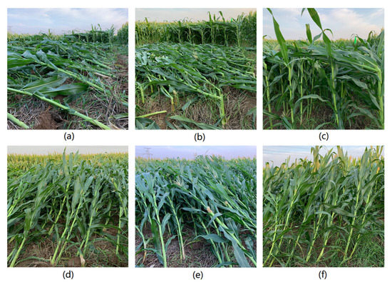
Figure 2.
Diagram of lodging. (a) RL: root lodging. (b) SF1: stem folding type 1. (c) SF2: stem folding type 2. (d) ST1: stem tilts 30 degrees. (e) ST2: stem tilt 45°. (f) ST3: stem tilt 60°.
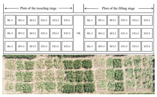
Figure 3.
Experimental area design, the picture above is the specific distribution of the plot, the picture below is an aerial view of the experimental area.
2.3. LiDAR Data Acquisition
The UAV-LiDAR data were collected twice, on 27 August 2020 and 6 September 2020. The laser scanner used to obtain the data was a VUX-1 UAV laser scanner produced by Riegl Company of Austria, and the parameters of the scanning instrument were set as shown in Table 1. As shown in Figure 4, the flight platform carrying the laser scanner was the M600 six-rotor UAV produced by the DJI of China. When the data were collected, the height of the UAV relative to the ground was 25 m, and the flight speed was 3 m/s. The same flight parameters were set for different sorties.

Table 1.
Main parameters of the laser scanner.
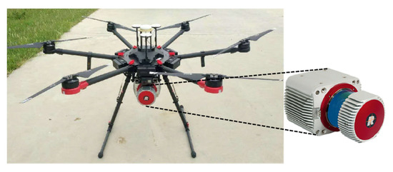
Figure 4.
The DJI M600 UAV with a RIEGLVUX-1UAV sensor.
Since artificial lodging in the filling stage was performed on 1 September, only LiDAR data of lodging maize at the tasselling stage were obtained on 27 August. The LiDAR data obtained on 6 September contained both the tasselling and filling stages. The same sensor parameters and flight routes were set for different UAV types. As the test area is set in a strip area with long north–south and narrow east–west, to ensure the uniform and sufficient acquisition of the point cloud data, a cross-flight route was set, as shown in Figure 1. There were six routes in single sorties, two in the north–south direction (NS1, NS2) and four in the east–west direction (EW1, EW2, EW3, EW4). The distance between the north–south routes was 20 m, and the distance between the east and west routes was 15 m. The point cloud densities of the different routes are shown in Table 2. The diameter of the laser points was 0.0075 m, and the average ground point spacing was 0.0156 m.

Table 2.
Point cloud density of the different routes.
2.4. Sample Collection
It is necessary to collect the plant height of the plot with different lodging types while obtaining the LiDAR data to verify the accuracy of the lodging maize canopy height extracted by LiDAR. To avoid morphological changes in maize plants, we immediately organised experimental personnel to measure the height of the maize plants in the experimental area after the completion of UAV-LiDAR data collection on 27 August and 1 September, which was a tower rule. To ensure measurement efficiency and accuracy, we randomly selected five maize plants in each plot to measure their plant height and recorded them; 105 groups of plant height in 21 plots were measured on 27 August, and 195 groups of plant height data of 39 plots were measured on 1 September. The data were recorded separately and used to verify the accuracy of the plant height extraction using LiDAR.
2.5. Data Preprocessing
The processing of UAV-LiDAR data is divided into two parts, namely, point cloud data preprocessing and point cloud data analysis. First is the preprocessing of the point cloud data. The original data derived from the LiDAR contains both point cloud data and route trajectory data. The point cloud data is in RXP format, which cannot be processed directly, so the data need to be resolved. The solution steps include trajectory solving, truncation of the route by time, matching the route with the point cloud, and converting the point cloud data to the commonly used LAS standard format. The specific processing flow is shown in Figure 5. POSPAC software was used to solve the route data, add the base station data to calibrate the route, and obtain an accurate trajectory. Secondly, RIPPROCESS software was used to truncate the trajectory by time, match the point cloud data with the processed trajectory, and input each parameter to solve the point cloud data. The point cloud data was spliced and visualised, and transferred to the format of LAS after processing. Finally were the analysis and processing of the point cloud data. LiDAR360 and Cloudcompare were used to preprocess the point cloud data, such as merging, denoising, filtering, and clipping, as well as constructing the digital canopy model. Then ArcGIS and LiDAR360 were used to extract the biomass, such as the canopy height and plant inclination angle.

Figure 5.
Laser point cloud data processing process.
2.6. Research Methods
2.6.1. Construction of the Canopy Height Model
The canopy height model (CHM) is an expression of vegetation canopy height, reflecting the vertical height change of the maize canopy and the horizontal distribution state, and can be used to extract the canopy height of a variety of lodging maize. The CHM is constructed based on the digital elevation model (DEM) and DSM. Therefore, it is necessary to create the DEM and DSM. DEM is a digital representation of the terrain surface morphology, and ground points are extracted by LIDAR360 software to construct the DEM. With the increase in maize lodging angle, the spacing between plants decreases, and the degree of overlap increases, leading to an inability to obtain sufficient ground points, resulting in the construction of DEM being higher than the actual ground elevation. To ensure the accuracy of CHM, we selected the sample points and obtained their elevation values on the bare ground between different plots in the experimental area. A Shapiro–Wilk normality test showed that the sample point data obeys a normal distribution. We used the ordinary Kriging method to spatially interpolate the sample points. The lag size is 0.316 m, and the spherical function is used as the semi-variogram model. The resolution of the DEM was set at 0.05 m. We cross-validated the sample points and prediction points of the DEM, the RMSE = 0.0186 and R2 = 0.974. The verification results showed that the accuracy of the interpolated DEM is high enough to support the construction of CHM. DSM refers to the ground elevation model containing a surface morphology of the surface objects, such as vegetation and buildings, and is constructed using surface point cloud data. Finally, similar to Formula (1), the difference between the DSM and DEM can be used to obtain the CHM of the test area, as shown in Figure 6. Figure 7 shows the 3D view of the CHM.
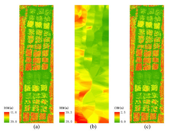
Figure 6.
CHM-generated schematic diagram: (a) DSM; (b) DEM; (c) CHM.
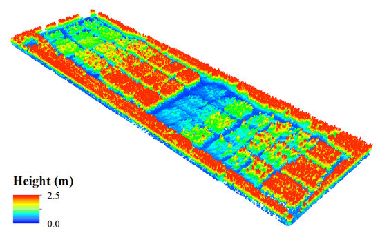
Figure 7.
3D view of the experimental area of the CHM.
2.6.2. Canopy Height Extraction
The most obvious effect of lodging stress on maize is the change in canopy height, and the extraction of canopy height is the key step in monitoring and evaluating the lodging degree. To verify the accuracy of the extraction of canopy height from UAV-LiDAR data, we compared the measured canopy height with the estimated value of the LiDAR on 6 September; when the UAV-LiDAR data were collected on September 6th, five groups of canopy heights were measured manually in each plot for verification. The CHM constructed using LiDAR data was used to extract ten canopy height groups in each plot. Due to the long experimental period, the measured canopy height and the estimated canopy height of the LiDAR could not be matched one by one because of the objective conditions. To ensure the objectivity of the data verification, the measured value and the estimated value of each plot were averaged respectively to represent the measured value and LiDAR-estimated value of this plot.
2.6.3. Lodging Angle Extraction
The lodging angle is one of the most intuitive biological indicators to evaluate the degree of maize affected by the lodging disasters. However, the previous lodging angle measurement is inefficient and difficult to extract the lodging angle in large lodging areas. The emergence of LiDAR technology and its application in lodging monitoring provide an effective technical means for extracting lodging angles. A large number of height values of the control check (CK) were extracted from the CHM. Their mean values were taken as the canopy height of normal growing maize. Then, a large number of height values were extracted from different plots, and their mean values were taken as the canopy height of different plots. As in Formula (2), the lodging angle could be calculated using the inverse trigonometric function, as shown in Figure 8.
where is the lodging angle, is the canopy height of different experimental plots, and is the canopy height of the control check. By comparing the lodging angle of maize extracted from the LIDAR data with the artificial data, we can determine the degree of influence of the lodging and the recovery ability after lodging.
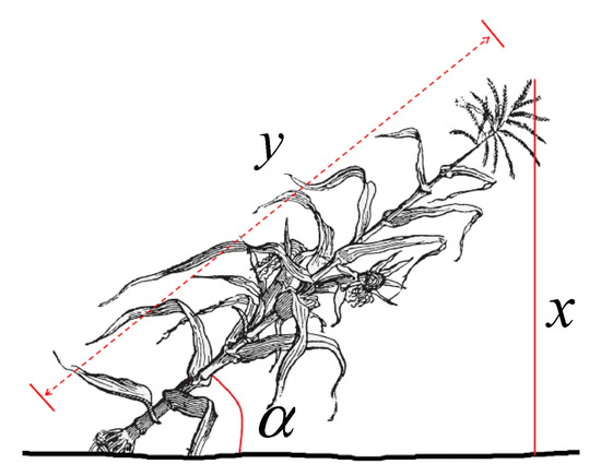
Figure 8.
Schematic diagram of lodging angle calculation.
2.7. Evaluation of Self-Recovery Ability
Study on the self-recovery ability of maize after lodging can provide reference data for maize yield estimation, mechanised harvesting, and other work in affected areas. To comprehensively study the self-recovery ability of maize, according to the principle of controlling variables, the research is carried out from two aspects: (1) lodging occurred in the tasselling stage and filling stage of maize, respectively, under the same conditions and after the same recovery time, analysing the differences in self-recovery ability at the different growth stages; and (2) differently serious lodging occurred in maize in the tasselling stage, and after a period of recovery under the same conditions, analyse the differences in the self-recovery ability of the different lodging types.
In order to quantitatively analyse the effects of lodging at different growth stages and different lodging severity on yield, we harvested the maize in the experimental area on 25 September. After drying, threshing, and weighing, 42 groups of dry weight data at the tasselling stage and filling stage were obtained. According to the row spacing, plant spacing, and the number of plants in each plot, the per unit yield of each lodging type at the tasselling stage and filling stage was calculated. The canopy height and lodging angle of the different lodging severities at the tasselling stage and the filling stage and their corresponding per unit yield were statistically analysed, and the effect of lodging on yield was quantitatively evaluated.
2.8. Accuracy Evaluation
The accuracy verification of the experimental results in this study is divided into two parts: (1) the accuracy verification of the estimation of canopy height by LiDAR and the measured canopy height; (2) the correlation verification of the correlation between the lodging angle estimated by LiDAR and the artificial layout of the maize lodging angle. The following parameters were selected to verify the accuracy of canopy height: determination coefficient (R2, Formula (3)), RMSE (Formula (4)), and normalised root mean square error (nRMSE, Formula (5)). R2 is the goodness of fit and the ratio of the sum of squares of regression and the sum of squares of total deviation; that is, the consistency between the estimated value and the measured value—the closer R2 is to 1, the higher the estimation accuracy. RMSE is the root mean square of the sum of squares of the difference between the measured canopy height and the estimated value of LiDAR, reflecting the degree of deviation between the estimated value and the true value. The nRMSE is the normalised root mean square error. Its value is between 0 and 1, and means the difference between the estimated value and the measured value. The smaller the value, the smaller the difference and the higher the estimation accuracy. The calculation formula is as follows:
where represents the measured value, represents the estimated LiDAR value, is the average value of the measured value, and is the number of samples.
The correlation coefficient ( Formula (6)) is used to describe the correlation between the estimated value and the measured value.
where represents the measured value, represents the estimated value of LiDAR, and and are the variances of the measured and estimated values, respectively.
3. Results and Analysis
3.1. Canopy Height Extraction and Verification
Through the processing and analysis of point cloud data, 21 groups of canopy height data at the tasselling stage and filling stage were obtained respectively (including RL, SF1, SF2, ST1, ST2, ST3, and CK, respectively). We compared it with the average value of the measured plant height, to verify the accuracy of obtaining canopy height from LiDAR data. The verification results are presented in Figure 9. The measured values at the tasselling and filling stages were significantly positively correlated with the estimated values of the LiDAR data (R2 = 0.9824, RMSE = 0.0613 m, and nRMSE = 3.745% at the tasselling stage. R2 = 0.9470, RMSE = 0.1294 m, and nRMSE = 9.889% at the filling stage).
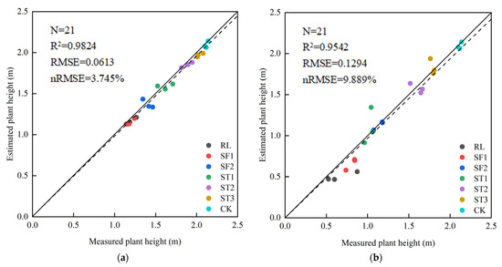
Figure 9.
Comparison of the measured plant height and estimated plant height on 6 September: (a) comparison of the tasselling stage; (b) comparison of the filling stage.
According to the validation results, in general, the canopy height of ST was significantly higher than that of SF and RL for the six lodging conditions set at the tasselling stage and filling stage. It is more obvious at the filling stage than at the tasselling stage, indicating that the effect of lodging stress gradually increased from ST to RL. Further subdivision showed that the canopy height of ST gradually increased with the increase in lodging angle; however, SF2, due to the ear of the maize being folded but not disconnected, and its morphology remained intact from the foot root to the bend, compared with SF1 and RL, the canopy height of SF2 is significantly higher, and its performance is more obvious in the filling stage with a shorter recovery period than in the tasselling stage. Second, it can be seen from Figure 9 that the correlation of the tasselling stage is higher than that at the filling stage, and the distribution continuity of the canopy height of different lodging types is stronger, which may be due to the longer recovery time of the experimental plants after lodging stress in the tasselling stage than that in the filling stage. However, due to the shorter recovery time in the filling stage, the difference in canopy height between different lodging types was larger. Moreover, it can be seen that the measured canopy height was larger than the estimated value of LiDAR overall.
3.2. Extraction and Analysis of the Lodging Angle
We used the LiDAR data from 6 September to extract and analyse the lodging angle, the average height of each plot was calculated, and the lodging angle of each plot was calculated using the inverse trigonometric function. There were 18 groups of lodging angle data during the tasselling stage and the filling stage and three groups for each artificial lodging type. The results are shown in Figure 10, between the estimated lodging angle at the tasselling stage and the set value, ρ = 0.947, and ρ = 0.809 at the filling stage, indicating the accuracy of the LiDAR estimation of the lodging angle.
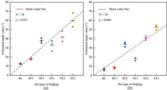
Figure 10.
Comparison of the lodging angle extracted from different experimental areas: (a) comparison of the tasselling stage; (b) comparison of the filling stage.
Figure 10 shows that because lodging stress occurred at different growth stages and the recovery time after lodging was different, the extraction results showed that the lodging angle at the tasselling stage was greater than that at the filling stage in the same lodging setting. Because of the longer recovery time in the tasselling experimental area, the average of the extracted lodging angles is greater than or equal to the set lodging angles, reflecting the strong self-recovery ability of this variety of maize. On the other hand, in the filling stage, the recovery time of the maize is shorter, and the lodging angle is lower overall, which indicates that the lodging stress is severe. It should be noted that since SF2 lodging is set to be folded at the ear position but not disconnected, the morphology remains intact from the foot root to bend position, and the canopy height and lodging angle change relatively little.
3.3. Plant Self-Recovery Ability Analysis
3.3.1. Analysis of Different Growth Stages
We used LiDAR data of the tasselling stage on 27 August and the filling stage on 6 September for comparative analysis. The data for the two periods were obtained approximately one week after artificial lodging. No extreme weather occurred during the entire lodging experiment cycle, and the meteorological conditions were relatively stable, which could be regarded as the same experimental conditions and recovery time. The canopy height and lodging angle were extracted from two stages of LiDAR data, and the comparison maps were drawn, and their standard deviations calculated. At the same time, to more intuitively compare the self-recovery ability after lodging stress at the tasselling and filling stages, LiDAR360 software was used to obtain the profiles of each lodging type, as shown in Figure 11.
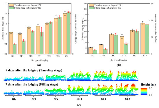
Figure 11.
Comparison of the recovery ability at different growth stages: (a) plant height contrast; (b) lodging angle contrast; (c) profile of the different growth stages.
As shown in Figure 11, under the same recovery conditions, after the same recovery time, the canopy height and lodging angle of RL and SF at the tasselling stage were significantly higher than those at the filling stage, because the growth ability of maize at the tasselling stage was higher than that at the filling stage. Therefore, the maize at the tasselling stage recovers faster than that at the filling stage after lodging stress, indicating that after the lodging stress, the self-recovery ability of maize at the tasselling stage is stronger than that at the filling stage. As can be seen from Figure 11a, the canopy height of maize at the tasselling stage of SF was lower than that at the filling stage, while it can be seen from Figure 11b that the lodging angle at the filling stage is smaller than that at the tasselling stage. The reason is that because of the tasselling stage, the maize artificial lodging experiment occurring 12 days earlier than the filling stage, so the experimental maize at the filling stage had a longer normal growth time, and the self-recovery ability of ST was more robust. Hence, its canopy height was higher than that at the tasselling stage. It can be seen intuitively from the profiles in Figure 11c that the lodging angle of the filling stage is smaller than that of the tasselling stage, while the height of the canopy at the filling stage is significantly higher than that at the tasselling stage, which verifies the accuracy of the above analysis. It can be concluded that under the same recovery conditions and after the same recovery time, the recovery degree of maize in the tasselling stage under lodging stress is stronger than that in the filling stage. Due to the same experimental conditions, it can be judged that under the lodging stress, the self-recovery ability of maize in the tasselling stage is stronger than that in the filling stage.
3.3.2. Analysis of Different Lodging Severity
To control variables and avoid the effects of different growth stages on the self-recovery ability, we used the LiDAR data of the tasselling stage on 27 August and 6 September for comparative analysis. The two datasets were acquired ten days apart, and the meteorological conditions were stable during the experiment. The canopy height and lodging angle of the two data periods were extracted, and the comparison maps were drawn, and LiDAR360 software was used to draw the profiles, as shown in Figure 12.
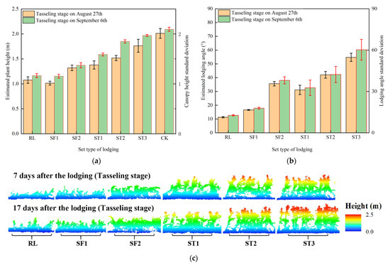
Figure 12.
Comparison of the recovery ability in the same growth stages: (a) plant height contrast; (b) lodging angle contrast; (c) profile of the different lodging severity.
As shown in Figure 12, after ten days of recovery, the canopy height and lodging angle of each lodging-type experimental area recovered to different degrees compared with that on 27 August. As shown in Figure 12a, ST increased significantly in canopy height, while RL and SF were relatively small, indicating that the more serious the lodging stress, the weaker the self-recovery ability. Such results are due to RL and SF damaging the support structure of the maize plants more seriously. In ST, with an increase in the lodging angle, the increase in plant height decreased gradually; this is because the stem tilt did not damage the root system and supporting structure of the plant and had a strong recovery ability, while the larger the lodging angle, the smaller the recovery space. Therefore, the increase in plant height decreases with the increase in lodging angle. As can be seen from Figure 12b, the lodging angle of SF2 is significantly higher than that of SF1 and ST1. Because the lodging angle of SF2 is set to be folded at the ear position but not disconnected, the shape remained intact from the foot root to the bend, and the canopy height after lodging was still higher than that of the former two, so the lodging angle was larger. In the recovery of the lodging angle, there is also an overall trend of RL < SF < ST. Figure 12c shows that the canopy height of RL and SF1 increased slightly, while ST changed significantly, and the lodging angle recovered. In summary, ST has the strongest self-recovery ability, SF and RL are weak, and RL has the weakest self-recovery ability. In addition, as can be seen from Figure 12, the variance in plant height and lodging angle generally increases with the decrease in lodging degree because the lighter the lodging degree, the stronger the recovery ability, and the subtle individual differences among plants will be magnified gradually with the recovery, and finally be reflected in the mean variance of the plant height and lodging angle.
3.3.3. Response of Yield to Plant Height and Lodging Angle
The effect of lodging on maize is not only reflected in the morphological structure parameters, such as canopy height and lodging angle, but has a more objective effect on yield. To quantitatively analyse the effects of the different growth stages and different lodging severities on yield, we harvested maize from 42 plots in the experimental area. We counted the number of plants, dry weight, and plot area of the maize in each plot, and calculated their per unit yield. To eliminate the accidental error, the average yield of three plots with the same lodging type was taken as its per unit yield. After calculation, 13 groups of per unit yield data were obtained. Taking the per unit yield of CK as the normal yield, the yield reduction rate of the different lodging types relative to the normal growing maize was calculated. The results are shown in Table 3.

Table 3.
Yield and yield reduction rate of different lodging types.
It can be seen from Table 3 that the yield reduction rate increases with the increase in lodging severity in the same growth stage. Among them, the yield reduction rate of RL is the highest, reaching 78.89% at the tasselling stage and 64.73% at the filling stage. The yield reduction rate of ST3 is the lowest, reaching 27.87% at the tasselling stage and 9.90% at the filling stage. Under the same lodging type, the yield reduction rate in the tasselling stage is significantly higher than that in the filling stage, which is 14.16~26.37% higher than that in the filling stage. There is a contradiction between this phenomenon and the self-recovery ability of maize at the tasselling stage, which is higher than that at the filling stage. To intuitively analyse the correlation between a different lodging severity and yield, we used the plant height and lodging angle estimated by LiDAR to analyse the correlation between the different lodging types and the corresponding yield. To control the variables, the data of the tasselling stage on 27 August and the filling stage on September 6 after the same recovery time were used for analysis.
As shown in Figure 13, the correlation coefficients between yield and plant height at the tasselling stage and filling stage were 0.909 and 0.888, respectively, while the correlation coefficients between yield and lodging angle were 0.864 and 0.877, respectively. The correlation coefficients of the four groups are all more than 0.85, showing a significant positive correlation, which showed that the per unit yield of maize decreased with the increase in lodging severity. From the trend line, it can be seen that the effect of lodging at the tasselling stage on the per unit yield of maize is more serious than that at the filling stage.
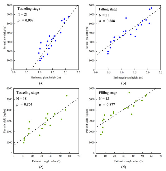
Figure 13.
Correlation analysis between the yield and lodging parameters: (a) correlation analysis between the plant height and per unit yield at the tasselling stage; (b) correlation analysis between the plant height and per unit yield at the filling stage; (c) correlation analysis between the lodging angle and per unit yield at the tasselling stage; (d) correlation analysis between the lodging angle and per unit yield at the filling stage.
4. Discussion
4.1. Comparative Analysis of the Research Method
At present, the satellite remote sensing technologies that are widely used in lodging assessing and crop yield estimation include optical remote sensing and radar remote sensing [13,38]. The satellite platform has the advantage of large area synchronous observation. However, after lodging, the chlorophyll content, water content, and morphological structure of crop plants will change, and the spectral and structural characteristics will change accordingly. It affects the correct evaluation of lodging by satellite remote sensing. Compared with the UAV-LiDAR technology used in this study, satellite remote sensing has some disadvantages, such as poor timeliness, easy to be limited by meteorological conditions in affected areas, and so on. To assess the lodging more accurately, Lisein et al. [39,40] obtained digital images by UAV, generated point cloud data using the motion structure method, and performed a 3D reconstruction to obtain the 3D model of the target area and then extracted the plant height of crops. The timeliness of the data acquisition is improved with this method, However, compared with the method of this study, due to the digital image being acquired passively, the accuracy is affected by the lighting conditions of the image acquisition and the information of the occluded parts and ground points cannot be obtained, so the accuracy of the extracted plant height data is low. The application of LiDAR technology has improved this problem very well. LiDAR can actively emit a laser beam to detect targets without being affected by light conditions [41], with an accuracy of up to the centimetre level [42]. It can obtain structural information and ground point information under the canopy of plants, providing technical support for the accurate extraction of plant height and inversion of lodging angle. Guo et al. [43] used a TLS to monitor the plant height during the whole growth period of wheat. The results showed that the height of wheat that can be accurately detected by TLS was as low as 0.18 m, the optimal crop height range was 0.42–0.9 m, and the optimal scanning step angle was 0.06°. The study showed that LiDAR could provide effective support for obtaining crop phenotypes. However, compared with the method of this study, the lidar is fixed on the ground, and the data can only be obtained in a small area in a single experiment, so the efficiency is low. The UAV platform has the advantages of flexible use, a fast response speed, and no damage to crop plant morphology [44]. Zhou et al. [36] used UAV-LiDAR technology to assess maize lodging, but only stayed at the level of analysing the plant height of the lodging maize, thus failing to make an in-depth study. In addition, the method used in this study also has some limitations: (1) Due to the limitation of the battery, the range of UAV is relatively short, compared with satellite remote sensing, and so lodging monitoring can only be carried out over a relatively small area. (2) The high cost of the LiDAR sensor limits its large-scale application. (3) The canopy of the crops in the lodging area often overlaps, affecting the acquisition of point cloud data below the canopy.
4.2. Analysis of Plant Height and Lodging Angle
Plant height is a key index for assessing the severity of lodging. As can be seen from Figure 9, the dispersion of sample points in the filling stage is greater than that in the tasselling stage because the recovery time in the filling stage is only one week, which is half of that in the tasselling stage, and there are great differences in canopy height among the different lodging types. After a long period of recovery in the tasselling stage, the plant height was relatively stable. Second, it can be seen from Figure 9 that most of the sample points in the tasselling and filling stages are located below the positive proportional function line, indicating that the plant height estimated by LiDAR is generally lower than the measured plant height. After analysing the way of obtaining data and the working principle of LiDAR, it is considered that the reasons for this phenomenon are as follows: (1) in the actual measurement, the plant height measured is from the ground to the top of the maize plant, but due to the squeezing effect of the maize root system on soil, the soil under the plant is slightly higher than the area without plants. Whereas, the DEM generated by the LiDAR point cloud is obtained by interpolation from the point cloud data in the experimental area, which will be slightly lower than the measured ground height, resulting in an error at the centimetre level. (2) In the actual measurement, the plant height of ST and CK is often higher than the height of the surveyor; when reading with the telescopic ruler, the measured value will be too large due to the up-looking reading. (3) When the UAV-LiDAR acquires the point cloud data of maize plants, the highest point of the lodging maize often appears at the top of the male ear or leaf, and the geometric size is small, and LiDAR cannot accurately capture the highest point, resulting in that when the plant height is retrieved by generating the CHM, the plant height obtained is smaller than the actual value.
The lodging angle is another important index for evaluating the severity of the lodging. Compared with plant height, lodging angle as an evaluation index of lodging degree can ignore the effect of different plant heights in different growth stages and have better objectivity and universality. As shown in Figure 10, the average lodging angle is different in different plots, and the lodging angle is RL < SF < ST on the whole. However, by analysing this figure, we can see that the lodging angle of SF2 is larger than that of SF1 and ST1; this is because SF2 is a relatively special lodging condition. After this lodging occurs, the upper part shows a typical lodging state, but the lower stem remains upright, so the plant height is higher; Figure 9 can also get the same result, so the lodging angle obtained by substituting it into the lodging angle calculation model is larger than that of SF1 and ST1. Second, by comparing Figure 10a,b, it can be seen that the same lodging setting is set, and the lodging angle at the filling stage is 5–10° larger than that at the tasselling stage. This difference in lodging angle is because the recovery time in the experimental area at the filling stage is ten days shorter than that at the tasselling stage, so there is a better recovery growth of the maize at the tasselling stage. At the same time, it is related to the different self-recovery abilities of maize at different growth stages.
4.3. Analysis of Self-Recovery Ability
The purpose of crop lodging assessing is to evaluate the loss, control disaster situations, and guide post-disaster rescue. It is of great significance to correctly understand the self-recovery ability of maize after lodging for disaster control and loss reduction. However, there are few studies on the recovery ability of maize after lodging in the world. In this study, the self-recovery ability of maize was analysed by using two indexes of plant height and lodging angle combined with yield.
The self-recovery ability of maize at different growth stages is different after lodging. The analysis of Figure 11 shows that under the same conditions, the self-recovery ability of maize at the tasselling stage is stronger than that at the filling stage, and the difference was the most obvious under the lodging types of RL and ST1. Such results are due to RL destroying the root system of the maize plant and ST1 destroying the support system near the root of the plant, leading to a decrease in the nutrient transport efficiency and a negative impact on the self-recovery ability of maize. Figure 11a,b showed that the plant height of maize at the filling stage is higher than that at the tasselling stage, but the lodging angle is less than the tasselling stage; this is since the normal growth time of maize at the filling stage is longer than that at the tasselling stage, and the absolute length of the plant is longer than that at the filling stage; it also shows that the lodging angle index can ignore the differences of maize in different growth stages and is more objective. However, as shown in Table 3, the yield reduction rate after lodging at the tasselling stage is 14.16–26.37% higher than that at the filling stage. Combined with the growth characteristics of maize, this contradictory phenomenon is due to the following: (1) The tasselling stage of maize is in the transitional stage from vegetative growth to reproductive growth. After lodging, the plant mainly uses nutrients to repair the damaged position, which has a negative effect on the formation and filling of maize kernels. (2) When lodging occurs in the filling stage of maize, it is in the stage of reproductive growth, the kernels of the maize has begun to fill, and the nutrients after lodging are still mainly supplied to the kernels.
The self-recovery ability of maize with a different lodging severity is also different. As shown in Figure 12, there is a 10-day difference in the recovery time of the maize lodging experiment corresponding to the data of the two periods. The plant height and lodging angle of maize with different lodging severities increased to different degrees, but the overall increase was RL < SF < ST, indicating that the self-recovery ability of maize after lodging was gradually weakened from the stem tilt and stem fracture to root lodging. The yield reduction rate of RL at the tasselling stage and filling stage was 78.89% and 64.73%, respectively, while that at ST3 was 27.87% and 9.90%, respectively. The correlation coefficients between plant height, lodging angle, and per unit yield exceeded 0.85, which proved this conclusion. This result is due to (1) RL from the fracture of the main root and half of the fibrous root, which destroys the supporting system of maize and affects the absorption and transport of nutrients. In addition, the exposed root system is more vulnerable to drought and insect pests, resulting in the worst self-recovery ability of maize; (2) SF1 is folded at 20 cm above ground but not disconnected, which also destroys the support system and nutrient delivery system of the maize, but the damage degree was less than that of RL, leading to its poor self-recovery ability; and (3) the lodging angle from SF1 to SF3 is different, but it maintains the integrity of the root and plant morphology, has a strong recovery ability, and the larger the lodging angle, the stronger the self-recovery ability. It can be seen that maize has a strong recovery ability after a lodging disaster. However, its recovery ability varies with lodging severity: under stable meteorological conditions, the more serious the lodging stress, the more serious the damage to the root and support system, and the weaker the self-recovery ability.
5. Conclusions
In this study, based on the artificial lodging field experiment, UAV-LiDAR technology was used to obtain the multi-temporal dense point clouds in the experimental area, the CHM was established, and the information of plant height and lodging angle was extracted. The variation in plant height and lodging angle of maize under different lodging types was analysed, and the measured data were used to verify its accuracy. The self-recovery ability of maize under lodging was analysed using LiDAR data of different time phases and yield data. The results show that:
(1) The point cloud data obtained by UAV-LiDAR can accurately estimate the plant height of the maize lodging. The estimation accuracy parameters of maize plant height at the tasselling stage were R2 = 0.9824, RMSE = 0.0613 m, and nRMSE = 3.745%. The estimated accuracy parameters at the filling stage were R2 = 0.9470, RMSE = 0.1294 m, and nRMSE = 9.889%.
(2) The point cloud data obtained by UAV-LiDAR can accurately estimate the lodging angle of maize, and the lodging angle index can evaluate the lodging degree objectively and universally.
(3) Maize has a strong self-recovery ability after lodging, which is stronger at the tasselling stage than at the filling stage. The self-recovery ability varies with the degree of lodging, and there is a negative correlation between the recovery ability and the damage degree of the root and support system.
(4) There was a significant positive correlation between maize yield and lodging severity, and the yield reduction rate after lodging in the tasselling stage is 14.16–26.37% higher than that in the filling stage.
(5) UAV-LiDAR technology can quickly and effectively assess maize lodging and describe and classify lodging situations using quantitative indicators.
This study verified the superiority of UAV-LiDAR in assessing maize lodging compared with traditional methods. Combined with the morphological structure parameters and yield data of lodging maize, the self-recovery ability of lodging with different severity at the tasselling stage and filling stage was quantitatively analysed. It provides guidance for rescue, loss assessment, and insurance claim settlement after maize lodging. Further research of monitoring and assessing of different maize varieties and longer growth cycles is needed, to expand its applicability.
Author Contributions
X.H., L.S. and X.G. conceived and designed the experiments; X.H., X.G., Q.S. and Z.W. performed the experiments; X.H. and X.G. proposed the methodology; X.H., L.S. and X.G. analysed the data; X.H., X.G. Q.S. and Y.P. verified the data; X.G., Y.P. and L.C. contributed to the materials/analysis tools; X.H. and L.S. wrote the paper. All authors have read and agreed to the published version of the manuscript.
Funding
This research was funded by the Platform Construction Funded Program of Beijing Academy of Agriculture and Forestry Sciences (Grant No. PT2021-35), the National Natural Science Foundation of China (Grant No. 41,571,323) and the Beijing Talents Project (Grant No. 2020A58).
Institutional Review Board Statement
Not applicable.
Informed Consent Statement
Not applicable.
Data Availability Statement
The data presented in this study are available on request from the corresponding author. The data are not publicly available due to the experimental data are collected by us independently, and the affiliation has confidentiality requirements on the data.
Acknowledgments
We extend our warm thanks to colleagues and students from the Department of Remote Sensing Technology of National Engineering Research Center for Information Technology in Agriculture, who provided experimental equipment including UAV and LIDAR, and provided technical support in the process of data acquisition.
Conflicts of Interest
The authors declare no conflict of interest.
References
- National Bureau of Statistics of China. Announcement of the National Bureau of Statistics on Grain Output Data in 2020. Available online: http://www.stats.gov.cn/tjsj/zxfb/202012/t20201210_1808377.html (accessed on 10 December 2020).
- China Meteorological Administration. China Blue Book on Climate Change (2020). Available online: http://www.cma.gov.cn/kppd/kppdqxyr/kppdjsqx/202008/t20200828_561907.html (accessed on 8 August 2020).
- Elmore, R. Mid-to Late-Season Lodging. Iowa State University Extension and Outreach. Available online: http://crops.extension.iastate.edu/corn/production/management/mid/silking.html (accessed on 6 January 2020).
- Berry, P.; Sterling, M.; Spink, J.; Baker, C.; Sylvester-Bradley, R.; Mooney, S.; Tams, A.; Ennos, A. Understanding and Reducing Lodging in Cereals. Adv. Agron. 2004, 84, 217–271. [Google Scholar] [CrossRef]
- Liu, X.; Gu, W.; Li, C.; Li, J.; Wei, S. Effects of nitrogen fertilizer and chemical regulation on spring maize lodging character-istics, grain filling and yield formation under high planting density in Heilongjiang Province, China. J. Integr. Agric. 2021, 20, 511–526. [Google Scholar] [CrossRef]
- Manga-Robles, A.; Santiago, R.; Malvar, R.A.; Moreno-González, V.; Fornalé, S.; López, I.; Luz Centeno, M.; Acebes, J.L.; Álvarez, J.M.; Caparros-Ruiz, D.; et al. Elucidating compositional factors of maize cell walls contributing to stalk strength and lodging resistance. Plant Sci. 2021, 307, 110882. [Google Scholar] [CrossRef] [PubMed]
- Bian, D.; Jia, G.; Cai, L.; Ma, Z.; Eneji, A.; Cui, Y. Effects of tillage practices on root characteristics and root lodging resistance of maize. Field Crop. Res. 2016, 185, 89–96. [Google Scholar] [CrossRef]
- Nleya, T.; Chungu, C.; Kleinjan, J. Corn Growth and Development. In iGrow Corn: Best Managemenent Practices, 1st ed.; SDSU Extension: Brookings, SD, USA, 2019; pp. 5–8. [Google Scholar]
- Xue, J.; Gou, L.; Zhao, Y.; Yao, M.; Yao, H.; Tian, J.; Zhang, W. Effects of light intensity within the canopy on maize lodging. Field Crop. Res. 2016, 188, 133–141. [Google Scholar] [CrossRef]
- Mi, C.; Zhang, X.; Li, S.; Yang, J.; Zhu, D.; Yang, Y. Assessment of environment lodging stress for maize using fuzzy synthetic evaluation. Math. Comput. Model. 2011, 54, 1053–1060. [Google Scholar] [CrossRef]
- Selkowitz, D.J.; Green, G.; Peterson, B.; Wylie, B. A multi-sensor lidar, multi-spectral and multi-angular approach for mapping canopy height in boreal forest regions. Remote Sens. Environ. 2012, 121, 458–471. [Google Scholar] [CrossRef]
- Bendig, J.; Bolten, A.; Bennertz, S.; Broscheit, J.; Eichfuss, S.; Bareth, G. Estimating Biomass of Barley Using Crop Surface Models (CSMs) Derived from UAV-Based RGB Imaging. Remote Sens. 2014, 6, 10395–10412. [Google Scholar] [CrossRef]
- Shu, M.; Zhou, L.; Gu, X.; Ma, Y.; Sun, Q.; Yang, G.; Zhou, C. Monitoring of maize lodging using multi-temporal Sentinel-1 SAR data. Adv. Space Res. 2020, 65, 470–480. [Google Scholar] [CrossRef]
- Yang, H.; Chen, E.; Li, Z.; Zhao, C.; Yang, G.; Pignatti, S.; Casa, R.; Zhao, L. Wheat lodging monitoring using polarimetric index from RADARSAT-2 data. Int. J. Appl. Earth Obs. Geoinf. 2015, 34, 157–166. [Google Scholar] [CrossRef]
- Peng, Y.; Zhu, T.; Li, Y.; Dai, C.; Fang, S.; Gong, Y.; Wu, X.; Zhu, R.; Liu, K. Remote prediction of yield based on LAI estimation in oilseed rape under different planting methods and nitrogen fertilizer applications. Agric. For. Meteorol. 2019, 271, 116–125. [Google Scholar] [CrossRef]
- Kanning, M.; Kühling, I.; Trautz, D.; Jarmer, T. High-Resolution UAV-Based Hyperspectral Imagery for LAI and Chlorophyll Estimations from Wheat for Yield Prediction. Remote Sens. 2018, 10, 2000. [Google Scholar] [CrossRef]
- Shendryk, Y.; Sofonia, J.; Garrard, R.; Rist, Y.; Skocaj, D.; Thorburn, P. Fine-scale prediction of biomass and leaf nitrogen content in sugarcane using UAV LiDAR and multispectral imaging. Int. J. Appl. Earth Obs. Geoinf. 2020, 92, 102177. [Google Scholar] [CrossRef]
- Liu, Y.; Liu, S.; Li, J.; Guo, X.; Wang, S.; Lu, J. Estimating biomass of winter oilseed rape using vegetation indices and texture metrics derived from UAV multispectral images. Comput. Electron. Agric. 2019, 166, 105026. [Google Scholar] [CrossRef]
- Yue, J.; Yang, G.; Tian, Q.; Feng, H.; Xu, K.; Zhou, C. Estimate of winter-wheat above-ground biomass based on UAV ultra-high-ground-resolution image textures and vegetation indices. ISPRS J. Photogram. Remote Sens. 2019, 150, 226–244. [Google Scholar] [CrossRef]
- Lu, J.; Cheng, D.; Geng, C.; Zhang, Z.; Xiang, Y.; Hu, T. Combining plant height, canopy coverage and vegetation index from UAV-based RGB images to estimate leaf nitrogen concentration of summer maize. Biosyst. Eng. 2021, 202, 42–54. [Google Scholar] [CrossRef]
- Cheng, J.; Zhang, X.; Sun, M.; Luo, P.; Yang, W. Random forest model for the estimation of fractional vegetation coverage based on a UAV-ground co-sampling strategy. J. Peking Univ. 2020, 56, 143–154. [Google Scholar] [CrossRef]
- Tao, H.; Feng, H.; Xu, L.; Miao, M.; Yang, G.; Yang, X.; Fan, L. Estimation of the Yield and Plant Height of Winter Wheat Using UAV-Based Hyperspectral Images. Sensors 2020, 20, 1231. [Google Scholar] [CrossRef]
- Song, Y.; Wang, J. Winter Wheat Canopy Height Extraction from UAV-Based Point Cloud Data with a Moving Cuboid Filter. Remote Sens. 2019, 11, 1239. [Google Scholar] [CrossRef]
- Kawamura, K.; Asai, H.; Yasuda, T.; Khanthavong, P.; Soisouvanh, P.; Phongchanmixay, S. Field phenotyping of plant height in an upland rice field in Laos using low-cost small unmanned aerial vehicles (UAVs). Plant Prod. Sci. 2020, 23, 1–14. [Google Scholar] [CrossRef]
- Zhang, N.; Su, X.; Zhang, X.; Yao, X.; Cheng, T.; Zhu, Y.; Cao, W.; Tian, Y. Monitoring daily variation of leaf layer photo-synthesis in rice using UAV-based multi-spectral imagery and a light response curve model. Agric. For. Meteorol. 2020, 291, 108098. [Google Scholar] [CrossRef]
- Guerra-Hernández, J.; González-Ferreiro, E.; Monleón, V.J.; Faias, S.P.; Tomé, M.; Díaz-Varela, R.A. Use of Multi-Temporal UAV-Derived Imagery for Estimating Individual Tree Growth in Pinus pinea Stands. Forest 2017, 8, 300. [Google Scholar] [CrossRef]
- Mohan, M.; Silva, C.A.; Klauberg, C.; Jat, P.; Catts, G.; Cardil, A.; Hudak, A.T.; Dia, M. Individual Tree Detection from Unmanned Aerial Vehicle (UAV) Derived Canopy Height Model in an Open Canopy Mixed Conifer Forest. Forest 2017, 8, 340. [Google Scholar] [CrossRef]
- Tirado, S.B.; Hirsch, C.N.; Springer, N.M. Utilizing temporal measurements from UAVs to assess root lodging in maize and its impact on productivity. Field Crop. Res. 2021, 262, 108014. [Google Scholar] [CrossRef]
- Wang, X.; Zhang, R.; Song, W.; Han, L.; Liu, X.; Sun, X.; Luo, M.; Chen, K.; Zhang, Y.; Yang, H.; et al. Dynamic plant height QTL revealed in maize through remote sensing phenotyping using a high-throughput unmanned aerial vehicle (UAV). Sci. Rep. 2019, 9, 1–10. [Google Scholar] [CrossRef]
- Wilke, N.; Siegmann, B.; Klingbeil, L.; Burkart, A.; Kraska, T.; Muller, O.; van Doorn, A.; Heinemann, S.; Rascher, U. Quan-tifying Lodging Percentage and Lodging Severity Using a UAV-Based Canopy Height Model Combined with an Objective Threshold Approach. Remote Sens. 2019, 11, 515. [Google Scholar] [CrossRef]
- Wang, X.; Yang, H.; Li, X.; Zheng, Y.; Yan, H.; Li, N. Research on maize growth monitoring based on visible spectrum of UAV remote sensing. Spectrosc. Spectr. Anal. 2021, 41, 265–270. [Google Scholar] [CrossRef]
- Sui, L. Active Radar and LiDAR Remote Sensing, 2nd ed.; Surveying and Mapping Press: Beijing, China, 2011; pp. 164–168. [Google Scholar]
- Hosoi, F.; Omasa, K. Estimating vertical plant area density profile and growth parameters of a wheat canopy at different growth stages using three-dimensional portable lidar imaging. ISPRS J. Photogramm. Remote Sens. 2009, 64, 151–158. [Google Scholar] [CrossRef]
- Crommelinck, S.; Höfle, B. Simulating an Autonomously Operating Low-Cost Static Terrestrial LiDAR for Multitemporal Maize Crop Height Measurements. Remote Sens. 2016, 8, 205. [Google Scholar] [CrossRef]
- Lei, L.; Qiu, C.; Li, Z.; Han, D.; Han, L.; Zhu, Y.; Wu, J.; Xu, B.; Feng, H.; Yang, H.; et al. Effect of leaf occlusion on leaf area index inversion of maize using UAV-LiDAR data. Remote Sens. 2019, 11, 1067. [Google Scholar] [CrossRef]
- Zhou, L.; Gu, X.; Cheng, S.; Yang, G.; Shu, M.; Sun, Q. Analysis of Plant Height Changes of Lodged Maize Using UAV-LiDAR Data. Agriculture 2020, 10, 146. [Google Scholar] [CrossRef]
- HeBei Meteorological Service. Shijiazhuang Climate Bulletin. 2019. Available online: http://he.cma.gov.cn/sjz/xwdt/gzdt/202001/t20200123_1406824.html (accessed on 23 January 2020).
- Zhou, L.; Cheng, S.; Sun, Q.; Gu, X.; Yang, G.; Shu, M.; Feng, H. Remote sensing of regional-scale maize lodging using mul-titemporal GF-1 images. J. Appl. Remote Sens. 2020, 14, 014514. [Google Scholar] [CrossRef]
- Lisein, J.; Pierrot-Deseilligny, M.; Bonnet, S.; Lejeune, P. A Photogrammetric Workflow for the Creation of a Forest Canopy Height Model from Small Unmanned Aerial System Imagery. Forest 2013, 4, 922–944. [Google Scholar] [CrossRef]
- Bendig, J.; Yu, K.; Aasen, H.; Bolten, A.; Bennertz, S.; Broscheit, J.; Gnyp, M.L.; Bareth, G. Combining UAV-based plant height from crop surface models, visible, and near infrared vegetation indices for biomass monitoring in barley. Int. J. Appl. Earth Obs. Geoinf. 2015, 39, 79–87. [Google Scholar] [CrossRef]
- Madec, S.; Baret, F.; De Solan, B.; Thomas, S.; Dutartre, D.; Jezequel, S.; Hemmerlé, M.; Colombeau, G.; Comar, A. High-Throughput Phenotyping of Plant Height: Comparing Unmanned Aerial Vehicles and Ground LiDAR Estimates. Front. Plant Sci. 2017, 8, 2002. [Google Scholar] [CrossRef]
- Virlet, N.; Sabermanesh, K.; Sadeghi-Tehran, P.; Hawkesford, M.J. Field Scanalyzer: An automated robotic field phenotyping platform for detailed crop monitoring. Funct. Plant Biol. 2017, 44, 143. [Google Scholar] [CrossRef]
- Guo, T.; Fang, Y.; Cheng, T.; Tian, Y.; Zhu, Y.; Chen, Q.; Qiu, X.; Yao, X. Detection of wheat height using optimized multi-scan mode of LiDAR during the entire growth stages. Comput. Electron. Agric. 2019, 165, 104959. [Google Scholar] [CrossRef]
- Wang, X.; Singh, D.; Marla, S.; Morris, G.; Poland, J. Field-based high-throughput phenotyping of plant height in sorghum using different sensing technologies. Plant Methods 2018, 14, 1–16. [Google Scholar] [CrossRef]
Publisher’s Note: MDPI stays neutral with regard to jurisdictional claims in published maps and institutional affiliations. |
© 2021 by the authors. Licensee MDPI, Basel, Switzerland. This article is an open access article distributed under the terms and conditions of the Creative Commons Attribution (CC BY) license (https://creativecommons.org/licenses/by/4.0/).