Article

Mapping Mature Post-Agricultural Forests in the Polish Eastern Carpathians with Archival Remote Sensing Data

by
Zofia Jabs-Sobocińska
1,*,
Andrzej N. Affek
2,
Ireneusz Ewiak
3 and
Mihai Daniel Nita
4
1
Faculty of Geography and Regional Studies, University of Warsaw, Krakowskie Przedmieście 30, 00-927 Warsaw, Poland
2
Institute of Geography and Spatial Organization, Polish Academy of Sciences, Twarda 51/55, 00-818 Warsaw, Poland
3
Faculty of Civil Engineering and Geodesy, Military University of Technology, Kaliskiego 2, 00-908 Warszawa, Poland
4
Department of Forest Engineering, Faculty of Silviculture and Forest Engineering, Transilvania University of Brasov, 1 Sirul Beethoven, 500 123 Brasov, Romania
*
Author to whom correspondence should be addressed.
Remote Sens. 2021, 13(10), 2018; https://doi.org/10.3390/rs13102018
Submission received: 13 April 2021 / Revised: 16 May 2021 / Accepted: 18 May 2021 / Published: 20 May 2021
(This article belongs to the Special Issue Remote Sensing for Land Cover and Vegetation Mapping)

Abstract

:
Post-WWII displacements in the Polish Carpathians resulted in widespread land abandonment. Most of the pre-war agricultural areas are now covered with secondary forests, which will soon reach the felling age. Mapping their exact cover is crucial to investigate succession–regeneration processes and to determine their role in the landscape, before making management decisions. Our goal was to map post-agricultural forests in the Polish Eastern Carpathians using archival remote sensing data, and to assess their connectivity with pre-displacement forests. We used German Flown Aerial Photography from 1944 to map agricultural lands and forests from before displacements, and Corona satellite images to map agricultural lands which converted into the forest as a result of this event. We classified archival images using Object-Based Image Analysis (OBIA) and compared the output with the current forest cover derived from Sentinel-2. Our results showed that mature (60–70 years old) post-agricultural forests comprise 27.6% of the total forest area, while younger post-agricultural forests comprise 9%. We also demonstrated that the secondary forests fill forest gaps more often than form isolated patches: 77.5% of patches are connected with the old-woods (forests that most likely have never been cleared for agriculture). Orthorectification and OBIA classification of German Flown Aerial Photographs and Corona satellite images made it possible to accurately determine the spatial extent of post-agricultural forest. This, in turn, paves the way for the implementation of site-specific forest management practices to support the regeneration of secondary forests and their biodiversity.

1. Introduction

Post-agricultural forests develop on former farmlands and differ in species composition from those with no record of agricultural use [1,2,3]. Nowadays, in many regions around the world, post-agricultural forests constitute a significant part of the total forest area [1,4,5]. There are many examples of mapping abandoned farmland [6,7] and forest cover changes [8,9], but limited research has focused on mapping post-agricultural forest in late succession stages. Post-agricultural forests develop in a different way than ancient forests and even several decades after agricultural land abandonment, they are still recovering [1,10,11]. Documenting their accurate extent is crucial to investigate succession–regeneration processes and compare them with ancient forests. Post-agricultural forests often seem to form uniform complexes with old forests, but the differences between them are significant for the natural environment [12,13]. For instance, forests with long continuous history are characterized by a higher biodiversity and occurrence of ancient forest species [2,13].
One of the main factors influencing the dispersal of forest species and affecting the regeneration is the connectivity with the ancient forest [1,2,10]. Mapping post-agricultural forests and old-woods (forests that most likely have never been cleared for agriculture) enables to further analyze the connectivity and, thus, the possibility of spreading species between them. Forest connectivity is also closely related with biodiversity. With the increasing interest and demand for biodiversity conservation, research on connectivity and forest cover changes become more and more needed [14,15]. It has also been found that the patch isolation and fragmentation affect the species richness and dispersal speed [14]. Moreover, the influence of past land use and past forest management on forest productivity and biodiversity has become one of the key ecological research questions in Europe [2,16] and in other regions of the world, e.g., in the USA [17] and Japan [18].
In most of the Carpathian Mts., the largest agricultural land abandonment happened between 1990 and 2000 after the collapse of communism [19], whereas in the eastern part of the Polish Carpathians, abandonment peaked in the 1940s. This region was inhabited by Ukrainians (Carpatho-Ruthenian ethnic groups) involved mainly in agriculture, who were forcibly displaced in the 1940s, and therefore, abandoned large areas of farmlands [20,21,22]. The event triggered a substantial and irreversible land-use regime shift, from an agriculturally dominated to forest-dominated regime [22]. Forests that developed on abandoned agricultural lands after the displacements are now 60–70 years old stands, which will soon reach the felling age. Therefore, it is crucial to determine their role in the landscape, before making forestry management decisions. In turn, a prerequisite for in-depth field research of post-agricultural forests is an accurate recognition of their spatial extent. The database of the Polish State Forests includes the information if the stand is of post-agricultural origin for some forest districts. However, even if included, such information is based mainly on uncertain post-war inventories and relates only to State Forests. The area of post-agricultural private forests has not yet been determined. Therefore, there is no consistent information on the overall extent of post-agricultural forests in the Polish Eastern Carpathians. In many places, the stands of post-agricultural and pre-displacement forests are in the similar age, but differ in terms of species composition and regeneration processes due to the past land use. Their exact area and the boundaries between old-woods and post-agricultural forest are not yet clearly defined.
Studies on land cover changes in the Carpathians from before the era of Landsat are mainly based on historical maps [19]. However, errors resulting from generalization, interpretation and comparison of maps with different scales and symbols cause significant uncertainty in land cover research [23]. More accurate results can be obtained from aerial photographs, but due to the low accessibility and difficult processing, such data from the WWII period are rarely used in land use research. Nonetheless, they have already been used to determine, e.g., the rate and pattern of tree invasion in Israel [24] and historical forest mapping in British Columbia [25]. Specifically, German Flown Aerial Photographs (the primary data in our research) were used, e.g., for the reconstruction of WWII fortifications in the Carpathians [26].
The most common method to classify panchromatic, historical aerial images is manual interpretation, but it is time-consuming, expensive and impossible over large areas [25,27]. One of the ways to speed up that process is the utilization of Object-Based Image Analysis (OBIA). OBIA is an automatic classification method that uses image objects instead of single pixels as basic units. The crucial step in OBIA is image segmentation, which groups pixels into shapes that represent individual objects. The next step is feature extraction and classification, the quality of which depends on segmentation accuracy [28,29]. This procedure has already been successfully applied to classify black and white images [8,30]. In archaeological and historical-geographic research, archival aerial photographs are usually georeferenced using ground control points, which leads to significant location errors, especially in mountain areas (see [26]). Orthorectification of aerial images is particularly important to eliminate errors resulting from the projection of varied terrain to a flat surface of images [31].
The impact of WWII on land cover is still poorly understood, mainly due to the limited availability of spatial data from that period [32]. However, recent studies in the Carpathians shed new light on the effects of war-induced human displacements on forest area increase [22] and transformations of pre-war farmland [33]. Still, the site specific forest succession that took place right after the displacements has not been mapped so far in sufficient detail, because the pre-war maps used in prior research were either of too low resolution (1:100,000) or were too distant in time from the displacements (the 1850s). Additionally, the post-war sources used have substantial time lag (showing state from the 1970s and 1980s, respectively), and therefore, distinguishing forests that developed in the first years after displacements from younger post-agricultural forests was not feasible on their basis. This might be only possible with the combination of high resolution data presenting the state just before and soon after the displacement-driven land abandonment.
A post-war data source that meets these criteria is the U.S. spy satellite Corona, acquiring images since 1960 [34]. However, it is still rarely used in land cover research, mainly due to the demanding orthorectification process [32] and lack of clear classification methods for black and white images [8]. Moreover, the use of Corona images for scientific research was not possible before their declassification in 1995 [8,32,35]. Only since then, Corona images have been used for mapping land cover changes in Senegal [35], forest cover changes in the Eastern United States, Central Brazil [36] and the Latvian-Russian border [8] and for the detection of forest cutting across Romania after WWII [32]. However, there are no studies using Corona images for mapping post-agricultural forests. Moreover, the forest cover in the Polish Eastern Carpathians from the 1960s has not yet been determined either.
The main goal of this work was, therefore, to map mature (60–70 years old) post-agricultural forests in the Polish Eastern Carpathians using German Flown Aerial Photographs and Corona satellite data, and define their connectivity with the old-woods. On the one hand, our research is methodological in nature, aimed at specialists seeking for alternative sources to investigate past land cover change or innovative processing of archival remote sensing data. On the other hand, the generated forest maps and connectivity data can help inform management decisions and provide the basis for further research on the regeneration of post-agricultural forests.

2. Methods

2.1. Study Area

Our study area is the Polish Eastern Carpathians, comprising two geographical regions: Bieszczady Mts. and Sanok-Turka Mts. (Figure 1), which together cover 221,244 ha.
The climate of the study area is temperate, additionally modified by altitudinal zonation and slope aspect. The division into three climatic zones, foothill, montane and alpine, is strictly connected with vegetation zonation and occurrence of oak-hornbeam forests, beech and fir forests and grassland communities, respectively [38,39,40]. Eastern Carpathians are built with the Carpathian Flysch (sandstones, conglomerates, shales, mudstones), on which mainly Eutric and Dystric Cambisols were formed [41,42].

2.2. Remote Sensing Data

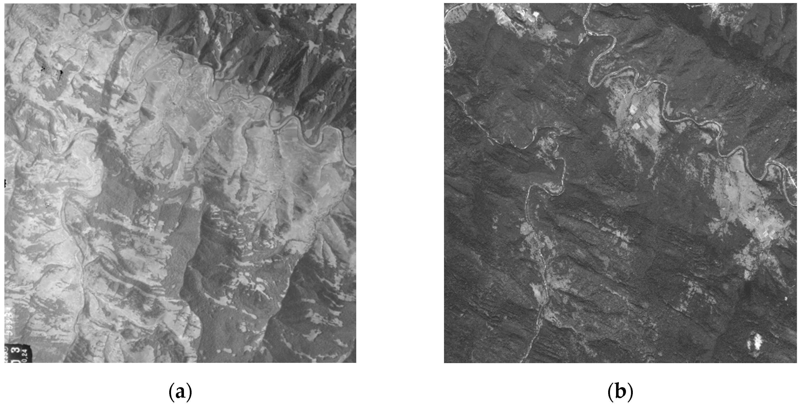
To map forests and agricultural areas from before displacements, we used the German Flown Aerial Photography from 1944 (Figure 2). To order the aerial photos from the U.S. National Archives and Records Administration (NARA) (https://catalog.archives.gov/id/306065; accessed on 13 April 2021), we first selected the 27 most suitable series. Then, we compared their extent with the study area to indicate the matching aerial images. In this way, we selected and ordered 50 panchromatic aerial images, 43 of which were further used for mapping. Images were of good quality, with no cloud cover, scanned with 1200 dpi (21 μm). They formed an irregular block of 15 strips, each containing from one to five photos. The longitudinal overlap in the strip ranged from 10% to 90%, while the lateral overlap ranged from 10% to 70%. Photos in the same strip had the same scale, while the denominator of the photo scale in different strips ranged from 18,000 to 30,000.
To map the forests which developed after the displacement, we used Corona satellite images obtained from the USGS EROS Archive (Figure 2). It is a collection of declassified military intelligence photographs from the satellite systems code-named Corona taken in 1960–1972 with ground resolution from 6 to 40 feet. The images were originally used to identify and create maps for U.S. intelligence agencies [34]. We obtained six pairs of stereographic film strips from the Corona mission. The data were acquired on September 25, 1969 and are available as panchromatic, stereographic image strips each covering about 17 × 230 km on the ground [43]. These data provide full coverage of our study area at a ground sampling distance resolution of 2.4 m. We chose satellite images from 1969 due to the best visibility of forest edges, without shades and clouds.
To map the most recent forest cover, we used Sentinel-2 (Table 1) satellite images obtained from USGS EROS Archive. Sentinel-2 is the Multispectral Instrument of the European Space Agency that provides global, 10 m resolution, multispectral images every 10 days. The scene analyzed was acquired on July 1, 2019 as a full-resolution True-Colour Image (RGB composite created from bands 4, 3, 2) [44].

2.3. Data Processing

The orthoimages from archival aerial photographs were generated using standard photogrammetric procedures in which the image distortions caused by their central projection were removed and the denivelation of the terrain covered by the images was taken into account [45]. We performed digital aerotriangulation to remove geometric distortions. In the absence of a camera calibration certificate, we determined the interior orientation of the aerial photos on the basis of the denominations of fiducial marks, taking into account the additional parameters compensating their affine distortion. The transformation accuracy of the image matrix to the ground coordinate system, measured by a standard deviation, was 10 μm. We determined the external orientation of the photos based on approximate coordinates of their projection centers identified and measured using the Google Maps service with an accuracy of 10 m as well as the control points. The control points were mainly road junctions and building ridges identified and measured with an accuracy of 3.5 m on a topographic map with a 1:10,000 scale. We measured image coordinates of 135 control points in manual and semi-automatic mode with an average error of 12 μm. The aerotriangulation accuracy (root mean square error, RMSE), was 2.5 m for plane coordinates and 1.5 m for elevation. The average error of determining the tie point ground coordinates was 4.5 m for plane coordinates and 2.5 m for the elevation. We took account of the impact of ground leveling by incorporating into the orthorectification process a digital terrain model acquired under SRTM mission (vertical accuracy assessed locally at 7.1 m [46]). The orthoimages of archival aerial photographs were verified based on reference data obtained from the current orthophoto with ground spatial resolution of 0.25 m. The orthorectification was performed in Trimble ApplicationsMaster 8.0.
To eliminate the distortions resulting from the Corona camera angle and the terrain, the photos were orthorectified. The images were geo-rectified using structure from motion algorithms implemented in AgiSoft PhotoScan (now Metashape), following a workflow developed specifically for Corona imagery [32]. We used SRTM v3 to extract Z coordinates for Ground Control Points and Google Maps high-resolution data for X and Y coordinates.
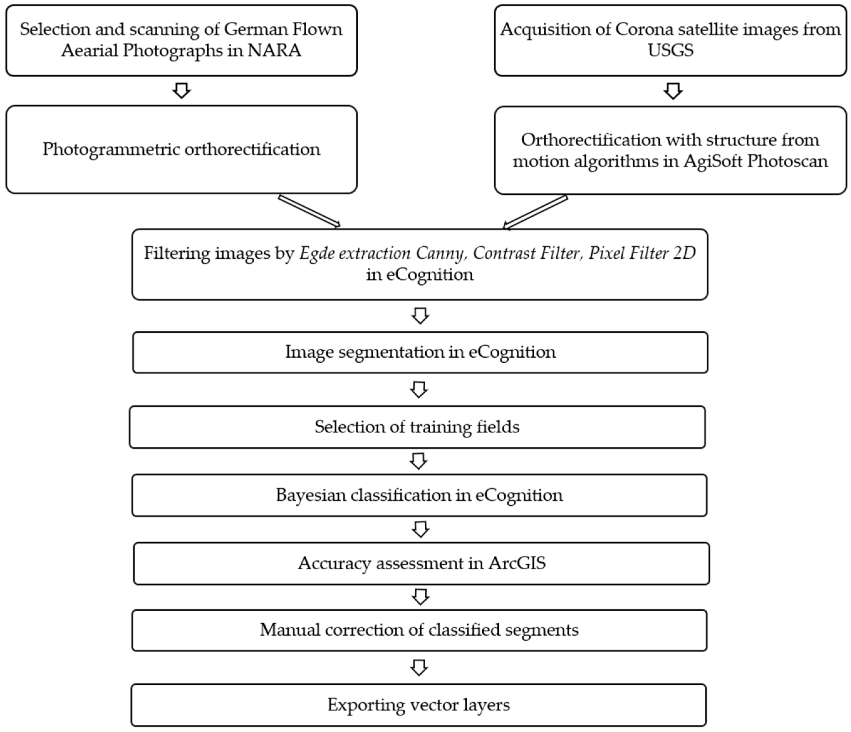
We mapped forest and agricultural areas on German Flown Aerial Photographs using Object-Based Image Analysis (OBIA) in eCognition Developer 10.0 software [47], followed by visual, manual verification. The first step in object classification was image cleaning by applying appropriate filters. We used Edge extraction Canny, i.e., a method of detecting the edges between objects in the image, Contrast Filter, i.e., filtering based on contrast, and Pixel Filer 2D, i.e., smoothing pixels and removing noise. The next key step was image segmentation, for which we had to select the appropriate scale. The Scale Parameter was established by testing the values of 50, 100, 150 and 200; a value of 100 was selected, as it gave the best result. The next step was to indicate training fields constituting segments representing a given class. The last step was the Bayesian classification [48], which is based on the collected samples of two classes and the values of objects such as brightness, the maximum difference between pixels, area, and complexity. After completing the classification, it was necessary to carefully examine the results and manually change the class for the incorrectly classified segments. In this way, we generated two layers: agricultural areas and forest areas from 1944, separately for each of the 43 aerial images. Then, to indicate the forest extent in 1969, the classification procedure was repeated in eCognition for Corona satellite images (Figure 3). Before manual correction, we assessed classification accuracy for both satellite and aerial images. We used Create Accuracy Assessment Points in ArcGIS software and manually validated the class for each point. Then, a confusion matrix was created to check the overall accuracy and Kappa coefficient values.
To extract forest cover from 2019 Sentinel-2 images, we performed supervised land cover classification in the semi-automatic classification plugin in QGIS software [49]. Then, we estimated the classification accuracy in ArcGIS software using the Create Accuracy Assessment Points and Compute Confusion Matrix tools in the Spatial Analyst extension.

2.4. Spatial Analysis

Based on the collected remote sensing materials, we distinguished three types of forests present today in the study area:
  • Old-woods (after Singleton et al. [50])—forests that existed before the displacement and most likely have never been cleared for agriculture;
  • Mature post-agricultural forest (after Singleton et al. [50])—stands currently in the age of 60–70, with closed canopies that had developed on land abandoned from agriculture in the 1940s;
  • Young post-agricultural forest—forest that developed on former farmlands after 1969.
To map the old-woods and post-agricultural forests, we combined the three remote sensing datasets (Supplementary Materials). Old-woods were those classified as forest in 1944 AND forest in 1969 AND forest in 2019. Mature post-agricultural forests were those that were classified as agriculture in 1944 AND forest in 1969 AND forest in 2019. Young post-agricultural forests, then, were those that were agriculture in 1944 AND non-forest in 1969 AND forest in 2019. To harmonize polygon boundaries between layers, we applied the ArcGIS tool Integrate with an x, y tolerance of 8 m. We set a minimum mapping unit at 1000 m2 to reduce the scalar mismatch and remove sliver polygons resulting from combining vector layers [51]. To assess connectivity between old-woods and post-agricultural forests, we used the Near function in ArcGIS. The tool calculates distance and other proximity measures between the input features (post-agricultural forest) and the closest feature in another layer (old-woods) [52]. To eliminate the influence of the missing old-woods outside our study area, we excluded post-agricultural patches adjacent to the study area border from the analysis. The Wilcoxon rank-sum test was used to check the significance of differences (a) in the median patch size between isolated and non-isolated patches, and (b) in the median distance from the old-woods to mature and young post-agricultural forests. The statistical analysis was conducted in R software. We also calculated the Largest Patch Index (percentage of the study area covered by the largest patch) and used it as a proxy inverse indicator of landscape fragmentation. It takes values from 0 to 100 and reaches 100 when the largest patch comprises 100% of the area [53]. We conducted the fragmentation analysis in QGIS software with LecoS plugin [49].

3. Results

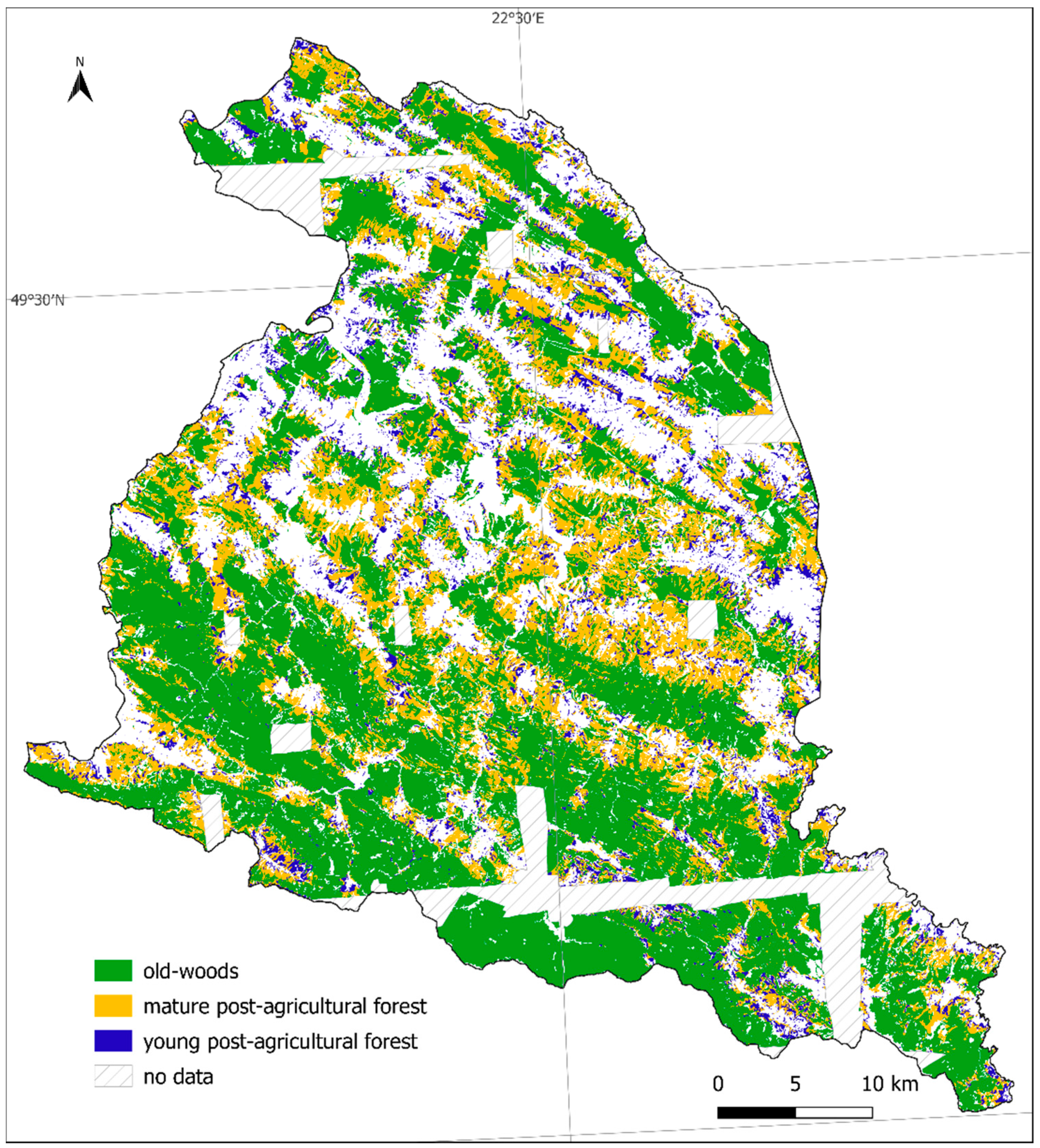
Our results showed that in the Polish Eastern Carpathians, there was 87,534 ha of old-woods, 40,526 ha of mature post-agricultural forests and 13,249 ha of young post-agricultural forests in 2019 (Figure 4). This represents respectively: 42.6%, 19.7% and 6.4% of the study area and 59.5%, 27.6% and 9% of all forests.
Our analysis showed that 22.5% of mature post-agricultural forest patches are isolated (4.4% of the post-agricultural forest area), while 77.5% of patches (95.6% in terms of area) are connected with the old-woods. In the case of young post-agricultural forests, 67% of patches are isolated (46.3% of young post-agricultural forest area) and 33% are connected (53.7% in terms of area). The Wilcoxon test showed that the distance to the old-woods from the young post-agricultural forest is significantly greater (p < 0.0001) than from the mature post-agricultural forest. Our results also showed that isolated, post-agricultural forest patches are significantly smaller than those which are connected with the old-woods (p < 0.0001). The Largest Patch Index for forest cover took the lowest values in 1944 (13%) and the highest in 2019 (45%). However, in 1969 it already reached 42%, which means that it increased the most between 1944 and 1969.
The orthorectification accuracy was high, with positional errors of Corona images between 0.5 and 3 pixels (corresponding to 1.2 and 7.2 m). The planar accuracy of the German Flown orthophoto based on the corresponding shift vectors was 4.5 m for both coordinates. Classification accuracy of Sentinel-2 images based on 506 samples gave the overall result of the Kappa statistics equal to 94%. The user’s accuracy for the class forest was 98.6% and the producer’s accuracy was 98.3%. Before manual verification and correction, the result of the Kappa statistics for one randomly selected aerial image was 77%. The user’s accuracy for agricultural area was 80%, while it was 95% for the forest area. In turn, the user’s accuracy of the classified Corona images before manual correction was 95% for the agricultural area and 98% for the forest area, with Kappa statistics equal to 94%.

4. Discussion

Orthorectification and classification of German Flown Aerial Photography and Corona images enabled us to track the forest succession on the abandoned agricultural area after the displacements in the 1940s. Mature post-agricultural forests constitute a substantial part of Carpathian forests. They are in the vast majority adjacent to the old-woods, which contributed to the forest fragmentation decrease. In turn, young post-agricultural forests cover a much lower share of the total forest area and are located further away from the old-woods.
It is widely accepted that the use of remote sensing data to study past land cover changes gives more accurate results than the analysis of generalized historical maps. This is because aerial photographs show the texture of the ground in much greater detail than maps [54]. As we aimed to obtain spatially explicit forest-cover changes in the post-WWII period, well before the era of Landsat imagery, our main challenge was to find and process suitable remote sensing data.
World War II triggered large changes in land use [32,55], but its analysis is difficult due to the problematic use of black and white data from the mid-20th century. Attempts to automatically classify black and white aerial photos have already been made by Morgan and Gergel [25], with an overall accuracy of 64.4%, and by Okeke and Karnieli [24], with 85% accuracy. In our approach, the crucial step was segmentation, which divides the image into homogeneous polygons. Then, the manual verification and correction of classified segments (by switching class for each wrongly classified polygon) is relatively fast and easy, but improves the accuracy considerably. Therefore, we argue that the application of German Flown Aerial Photographs and Corona satellite imagery, processed in line with our methodological approach, has high potential to improve the mapping of land cover from the post-WWII period also in other regions, and thus, influence significantly the contemporary forest management [32,56]. However, it should be remembered that combining source materials with different scales and resolutions carries the risk of drawing false conclusions due to scalar mismatch. Artificial scraps or gaps may appear when vector layers resulting from the classification of different source materials are intersected. We solved this problem by integrating polygon boundaries and setting the common minimum mapping unit (eliminating all polygons and gaps smaller than 1000 m2). Besides processing, the remote selection and acquisition of appropriate German Flown Aerial Photographs from NARA were also challenging, mainly due to the inability to verify their quality and exact cover before ordering. Not all ordered photos were suitable for land cover classification due to poor quality or lack of available ground control points in forested areas. Because of the poor quality, the inaccurate location of some ordered photos and the lack of available aerial images for part of the region, 7% of the study area was not mapped (19% of the unmapped area is now open land, which gives an even smaller percentage of missing forest information). Therefore, we believe that the general trends of post-war forest succession in the Polish Eastern Carpathians have been captured.
We used several software packages to achieve our goal. Working with two GIS packages (ArcGIS and QGIS) and two photogrammetric packages (ApplicationsMaster and PhotoScan) was somewhat redundant and was mainly due to the different preferences of the authors of this study. For instance, all analyses run in QGIS could have also been performed in ArcGIS, but not the other way around (e.g., the Near function is not available in QGIS). Nonetheless, a further reduction of the number of used software packages is rather unlikely; we are not aware of a package that can perform both OBIA and photogrammetric processing. Additionally, eCognition, the software we used for OBIA, achieves more accurate results than other available software packages such as OTB/Monteverdi and ArcGIS [57]. Moreover, eCognition enables to perform cleaning and filtering the image before classification, which improved substantially our results. Agisoft Metashape is a stand-alone software product that performs photogrammetric processing of digital images and generates 3D spatial data. The digital images which can be processed through the software should be produced in stereographic pair as the base photogrammetric process is Structure From Motion. This approach is suitable for Corona mission images [8,32] since the images are in a stereographic pair. The German Flown Aerial Photographs were not produced in a stereographic pair to create a specific Structure From Motion bundle adjustment; therefore, the Application Master 8.0 was used.
Due to the differences in the functioning of the old-woods and the post-agricultural forests, their recognition and delineation is very important. The agricultural use of land originally covered with forests causes a significant and long-lasting change in soil [58]. One of the most impactful changes is the elimination of plant and seeds of forest species. It has been shown that soil recovering from agriculture has higher pH and the differences are visible even 100 years after agricultural abandonment [1]. Lack of forest plant seeds and modified soil conditions mean that forests developing after agricultural land abandonment differ in species composition from the old-woods. The rate of forest regeneration depends mainly on the distance from the old-wood edge, soil fertility, seed dispersal and the length of the regeneration period. The process is faster at a closer distance from the old-woods, which is the seed source of the forest species [10], so the connectivity is a useful measure which can help assess the post-agricultural forest regeneration.
Post agricultural forests constitute a significant part of the lowland forests. For instance, Matuszkiewicz et al. [10] indicated that 65.8% of forests in Masuria and 54.2% of forests in Kurpie (both in NE Poland) are post-agricultural. The dominant share of post-agricultural woodlands in the total forest area was also reported for New England [59] and the Netherlands [60]. The share of post-agricultural forest in our study area is not that large (36.6%, of which 27.6% was mature and 9% young) due to the location in the mountains highly forested already before displacements (45% of the study area in 1944). In the last few decades, forest expansion after agricultural abandonment was observed in the Swiss mountains [61] and after the collapse of socialism in the Carpathians and post-soviet Russia [62,63,64]. However, forests that developed on abandoned agricultural lands soon after World War II have not been investigated enough, and therefore, the succession processes and patterns of afforestation are still poorly understood (however, see [22,65]).
Post-WWII forest cover changes were already investigated in the Carpathian Mts. based on topographical maps, but the majority of studies analyzed longer time intervals and did not extract changes that occurred soon after WWII (e.g., [23,66]). We are aware of only one local case study from the Wiar river basin (230 km2) that made use of military topographic maps 1:25,000 from the 1950s to capture short-term and direct land cover changes following WWII. The authors showed that forest cover increased from 39% in 1936 to 48% in 1958 and linked it with a dramatic population decline resulting from post-war displacements [65]. Nonetheless, the above study, like many others in the Polish Carpathians, used the low resolution 1:100,000 topographic map from the 1930s to show the pre-war land cover. For instance, Kozak [66] compared this map with Landsat satellite images from 2001 to analyze land cover changes in the Western Carpathians. In turn, Kaim et al. [23] used the same pre-war map series and the topographical map from the 1970s to capture land cover changes in the Carpathians and highlighted the disadvantages of their use [23]. Our study is the first to apply archival German Flown Aerial Photographs to reconstruct the forest cover just before the displacements and land abandonment that took place in the Carpathians in the 1940s. The application of German Flown Aerial Photographs and Corona images may be an alternative to the widespread use of archival topographical maps in the mid-20th century landscape reconstructions and help extract land use and land cover changes directly resulting from World War II.
Our results showed that currently in the Polish Carpathians, there are more than 40,500 ha of 60–70 years old post-agricultural forests. According to Flinn and Vellend [1], they are old enough to analyze regeneration and compare species composition with neighboring ancient forests. Old-woods cover 87,534 ha and are in large part well preserved old-growth forests protected by the East Carpathians Biosphere Reserve [67]. Based on the analysis of the 19th century maps (www.mapire.eu; accessed on 13 April 2021) and the history of intensive farming by the Ukrainian-speaking population from before the displacement [21], we may assume that the majority of old-woods are ancient forests, i.e., were never cleared for agriculture. This provides a great opportunity to compare mature post-agricultural forests with forests with no record of agricultural use, for instance in terms of ancient forest species. It is crucial to analyze the regeneration processes and species composition in mature post-agricultural forests, before the light conditions will be disturbed as a result of logging.
Connectivity and distance to the ancient forests are well-known factors impacting forest regeneration. Greater distance to the ancient forest slows down regeneration and dispersal of forest species [1,2,10,60]. The fact that 95.6% of mature post-agricultural forest in our study area is connected with the old-woods (which most likely were never converted into farmland) provides good conditions for the spreading of ancient forest species. We also showed that the development of post-agricultural forests after population displacement contributed to forest fragmentation decrease and an increase in mean forest patch size. This effect may be beneficial not only for forest plant species but also for forest animal species, especially for big mammals, of which populations increased in the last few decades [68].
The Largest Patch Index, the proxy inverse measure for landscape fragmentation, increased the most between 1944 and 1969, soon after population displacement. In contrast to our study, Kozak et al. [69] reported increasing forest fragmentation between 1930 and 1970 in the Polish Carpathians. This discrepancy is probably related to the fact that Kozak et al. [69] analyzed the entire Polish Carpathians, and not only the displaced part. It is worth noting that we did not exclude roads from forest patches in any of the three time slices. If roads were taken into account, the Largest Patch Index would most likely grow a bit less. Nonetheless, the comparison of the two studies highlights the strong impact of human displacement on forest cover changes.
Young post-agricultural forest patches which are directly connected with the old-woods constitute only 53.7% of that forest area. This situation provides much worse regeneration conditions and a smaller possibility for effective seed dispersal from ancient to young forests. This result also gives an idea of the sequence of overgrowing former farmlands. The significant difference in the distance to old-woods reflects the general tendency to overgrow the fields located near the forest edge and further from the village first. Pazúr et al. [70] showed, for Slovakia, that those abandoned farmlands which were located further away from the forest edge were re-cultivated. Furthermore, in Russia, the transition from farmland to forest was more likely to be closer to the forest edge [63]. Our analysis showed that farmlands still cultivated in the second half of the 20th century were located further away from the old-woods than those which were abandoned.
In summary, we found that 60–70 years old post-agricultural forests cover large areas in the Polish Eastern Carpathians. However, in contrast to some other regions, here, the old-woods cover a much larger area than the post-agricultural forests. We showed that mature post-agricultural forests are well connected with the old-woods in the post-displacement areas, which allows effective dispersal of ancient forest species and accelerate their regeneration. In turn, younger post-agricultural forests are located at a greater distance from the old-woods, which may suggest that they will regenerate comparably slower in the future. We also demonstrated that by the use of panchromatic remote sensing data from the mid-20th century, it is possible to accurately extract forest area and study the direct effects of WWII on land cover. Our original approach to orthorectify and classify German Flown Aerial Photographs enabled the tracking of forest succession. The knowledge about the exact spatial extent of mature post-agricultural forests in the Polish Eastern Carpathians can be used in forest management and in research on the regeneration of secondary forests.

Supplementary Materials

Supplementary material is available online at https://www.mdpi.com/article/10.3390/rs13102018/s1; it is a Shapefile with the exact spatial extent of old-woods, mature post-agricultural forests and young post-agricultural forests in the Polish Eastern Carpathians.

Author Contributions

Conceptualization, Z.J.-S. and A.N.A.; Data curation, Z.J.-S.; Formal analysis, Z.J.-S.; Funding acquisition, Z.J.-S.; Investigation, Z.J.-S.; Methodology, Z.J.-S., A.N.A., I.E. and M.D.N.; Project administration, Z.J.-S.; Resources, Z.J.-S.; Supervision, A.N.A.; Validation, Z.J.-S.; Visualization, Z.J.-S.; Writing—original draft, Z.J.-S., A.N.A., I.E. and M.D.N.; Writing—review and editing, Z.J.-S., A.N.A., I.E. and M.D.N. All authors have read and agreed to the published version of the manuscript.

Funding

This research was funded by the National Science Centre, Poland, grant number 2019/35/N/ST10/01923.

Data Availability Statement

The data presented in this study are available in the Supplementary Materials.

Acknowledgments

This work was supported by the Polish National Science Centre (Grant No. 2019/35/N/ST10/01923) and the University of Warsaw. We thank Jan Marek Matuszkiewicz, the project supervisor, for his valuable suggestions and comments. We also thank the two anonymous reviewers for their suggestions that greatly helped to improve the manuscript.

Conflicts of Interest

The authors declare no conflict of interest.

References

  1. Flinn, K.M.; Vellend, M. Recovery of forest plant communities in post-agricultural landscapes. Front. Ecol. Environ. 2005, 3, 243–250. [Google Scholar] [CrossRef]
  2. Bergès, L.; Dupouey, J.L. Historical ecology and ancient forests: Progress, conservation issues and scientific prospects, with some examples from the French case. J. Veg. Sci. 2019, 1–17. [Google Scholar] [CrossRef]
  3. Matuszkiewicz, J.M.; Kowalska, A.; Kozłowska, A.; Roo-Zielińska, E.; Solon, J. Differences in plant-species composition, richness and community structure in ancient and post-agricultural pine forests in central Poland. For. Ecol. Manag. 2013, 310, 567–576. [Google Scholar] [CrossRef] [Green Version]
  4. D’Orangeville, L.; Bouchard, A.; Cogliastro, A. Post-agricultural forests: Landscape patterns add to stand-scale factors in causing insufficient hardwood regeneration. For. Ecol. Manag. 2008, 255, 1637–1646. [Google Scholar] [CrossRef]
  5. Naaf, T.; Kolk, J. Colonization credit of post-agricultural forest patches in NE Germany remains 130–230 years after reforestation. Biol. Conserv. 2015, 182, 155–163. [Google Scholar] [CrossRef] [Green Version]
  6. Estel, S.; Kuemmerle, T.; Alcántara, C.; Levers, C.; Prishchepov, A.; Hostert, P. Mapping farmland abandonment and recultivation across Europe using MODIS NDVI time series. Remote Sens. Environ. 2015, 163, 312–325. [Google Scholar] [CrossRef]
  7. Alcantara, C.; Kuemmerle, T.; Prishchepov, A.V.; Radeloff, V.C. Mapping abandoned agriculture with multi-temporal MODIS satellite data. Remote Sens. Environ. 2012, 124, 334–347. [Google Scholar] [CrossRef]
  8. Rendenieks, Z.; Nita, M.D.; Nikodemus, O.; Radeloff, V.C. Half a century of forest cover change along the Latvian-Russian border captured by object-based image analysis of Corona and Landsat TM/OLI data. Remote Sens. Environ. 2020, 249, 1–14. [Google Scholar] [CrossRef]
  9. Kozak, J.; Estreguil, C.; Troll, M. Forest cover changes in the northern Carpathians in the 20th century: A slow transition. J. Land Use Sci. 2007, 2, 127–146. [Google Scholar] [CrossRef]
  10. Matuszkiewicz, J.M.; Kowalska, A.; Solon, J.; Degórski, M.; Kozłowska, A.; Roo-Zielińska, E.; Zawiska, I.; Wolski, J. Long-Term Evolution Models of Post-Agricultural Forests; Institute of Geography and Spatial Organization Polish Academy of Sciences: Warsaw, Poland, 2013; Volume 240, ISBN 9788361590293. [Google Scholar]
  11. Kopecký, M.; Vojta, J. Land use legacies in post-agricultural forests in the Doupovské Mountains, Czech Republic. Appl. Veg. Sci. 2009, 12, 251–260. [Google Scholar] [CrossRef]
  12. Sciama, D.; Augusto, L.; Dupouey, J.-L.; Gonzalez, M.; Moares Domínguez, C. Floristic and ecological differences between recent and ancient forests growing on non-acidic soils. For. Ecol. Manag. 2009, 258, 600–608. [Google Scholar] [CrossRef]
  13. Dupouey, J.L.; Dambrine, E.; Laffite, J.D.; Moares, C. Irreversible Impact of Past Land Use on Forest Soils and Biodiversity. Ecology 2002, 83, 2978–2984. [Google Scholar] [CrossRef]
  14. Bailey, S. Increasing connectivity in fragmented landscapes: An investigation of evidence for biodiversity gain in woodlands. For. Ecol. Manag. 2007, 238, 7–23. [Google Scholar] [CrossRef]
  15. UNEP. Frontiers 2017 Emerging Issues of Environmental Concern; UNEP: Nairobi, Kenya, 2017.
  16. Ammer, C.; Fichtner, A.; Fischer, A.; Gossner, M.M.; Meyer, P.; Seidl, R.; Thomas, F.M.; Annighöfer, P.; Kreyling, J.; Ohse, B.; et al. Key ecological research questions for Central European forests. Basic Appl. Ecol. 2018, 32, 3–25. [Google Scholar] [CrossRef]
  17. Kuhman, T.R.; Pearson, S.M.; Turner, M.G. Agricultural land-use history increases non-native plant invasion in a southern Appalachian forest a century after abandonment. Can. J. For. Res. 2011, 41, 920–929. [Google Scholar] [CrossRef]
  18. Ito, S.; Nakayama, R.; Buckley, G.P. Effects of previous land-use on plant species diversity in semi-natural and plantation forests in a warm-temperate region in southeastern Kyushu, Japan. For. Ecol. Manag. 2004, 196, 213–225. [Google Scholar] [CrossRef]
  19. Munteanu, C.; Kuemmerle, T.; Boltiziar, M.; Butsic, V.; Gimmi, U.; Halada, L.; Kaim, D.; Király, G.; Konkoly-Gyuró, É.; Kozak, J.; et al. Forest and agricultural land change in the Carpathian region—A meta-analysis of long-term patterns and drivers of change. Land Use Policy 2014, 38, 685–697. [Google Scholar] [CrossRef]
  20. Eberhardt, P. Political Migrations on Polish Territories (1939–1950); Institute of Geography and Spatial Organization Polish Academy of Sciences: Warsaw, Poland, 2011. [Google Scholar]
  21. Korzeniak, J.; Kucharzyk, S. Zmiany w szacie roślinnej od połowy XIX w. do czasów współczesnych. In Bojkowszczyzna Zachodnia—Wczoraj, Dziś i Jutro, Tom II; Wolski, J., Ed.; Institute of Geography and Spatial Organization Polish Academy of Sciences: Warsaw, Poland, 2016. [Google Scholar]
  22. Affek, A.N.; Wolski, J.; Zachwatowicz, M.; Ostafin, K.; Radeloff, V.C. Effects of post-WWII forced displacements on long-term landscape dynamics in the Polish Carpathians. Landsc. Urban Plan. 2021. in review. [Google Scholar]
  23. Kaim, D.; Kozak, J.; Ostafin, K.; Dobosz, M.; Ostapowicz, K.; Kolecka, N.; Gimmi, U. Uncertainty in historical land-use reconstructions with topographic maps. Quaest. Geogr. 2014, 33, 55–63. [Google Scholar] [CrossRef] [Green Version]
  24. Okeke, F.; Karnieli, A. Methods for fuzzy classification and accuracy assessment of historical aerial photographs for vegetation change analyses. Part II: Practical application. Int. J. Remote Sens. 2006, 27, 1825–1838. [Google Scholar] [CrossRef]
  25. Morgan, J.L.; Gergel, S.E. Automated analysis of aerial photographs and potential for historic forest mapping. Can. J. For. Res. 2013, 43, 699–710. [Google Scholar] [CrossRef]
  26. Jucha, W.; Franczak, P.; Sadowski, P. Detection of World War II field fortifications using ALS and archival aerial images—German OKH Stellung b1 trenches in the south of the Polish Carpathians. Archaeol. Prospect. 2020, 1–11. [Google Scholar] [CrossRef]
  27. Cots-Folch, R.; Aitkenhead, M.J.; Martínez-Casasnovas, J.A. Mapping land cover from detailed aerial photography data using textural and neural network analysis. Int. J. Remote Sens. 2007, 28, 1625–1642. [Google Scholar] [CrossRef]
  28. Hossain, M.D.; Chen, D. Segmentation for Object-Based Image Analysis (OBIA): A review of algorithms and challenges from remote sensing perspective. ISPRS J. Photogramm. Remote Sens. 2019, 150, 115–134. [Google Scholar] [CrossRef]
  29. Blaschke, T. Object based image analysis for remote sensing. ISPRS J. Photogramm. Remote Sens. 2010, 65, 2–16. [Google Scholar] [CrossRef] [Green Version]
  30. Blackman, R.; Yuan, F. Detecting Long-Term Urban Forest Cover Change and Impacts of Natural Disasters Using High-Resolution Aerial Images and LiDAR Data. Remote Sens. 2020, 12, 1820. [Google Scholar] [CrossRef]
  31. Pinto, A.T.; Gonçalves, J.A.; Beja, P.; Pradinho Honrado, J. From Archived Historical Aerial Imagery to Informative Orthophotos: A Framework for Retrieving the Past in Long-Term Socioecological Research. Remote Sens. 2019, 11, 1388. [Google Scholar] [CrossRef] [Green Version]
  32. Nita, M.D.; Munteanu, C.; Gutman, G.; Abrudan, I.V.; Radeloff, V.C. Widespread forest cutting in the aftermath of World War II captured by broad-scale historical Corona spy satellite photography. Remote Sens. Environ. 2018, 204, 322–332. [Google Scholar] [CrossRef]
  33. Jabs, Z.J. Uwarunkowania i Kierunki Przekształceń Dawnych Pól Ornych po Wysiedleniach Lat 40. XX Wieku w Beskidach. (Determinants and Directions of Changes of Former Farmlands after Population Displacement in the 1940s in the Beskid Mountains). Master’s Thesis, University of Warsaw, Warsaw, Poland, 2019. [Google Scholar]
  34. USGS. USGS EROS Archive—Declassified Data—Declassified Satellite Imagery—3. Available online: https://www.usgs.gov/centers/eros/science/usgs-eros-archive-declassified-data-declassified-satellite-imagery-1?qt-science_center_objects=0#qt-science_center_objects (accessed on 12 October 2020).
  35. Tappan, G.G.; Hadj, A.; Wood, E.C.; Lietzow, R.W. Use of Argon, Corona, and Landsat imagery to assess 30 years of land resource changes in west-central Senegal. Photogramm. Eng. Remote Sens. 2000, 66, 727–735. [Google Scholar]
  36. Song, D.X.; Huang, C.; Sexton, J.O.; Channan, S.; Feng, M.; Townshend, J.R. Use of Landsat and Corona data for mapping forest cover change from the mid-1960s to 2000s: Case studies from the Eastern United States and Central Brazil. ISPRS J. Photogramm. Remote Sens. 2015, 103, 81–92. [Google Scholar] [CrossRef] [Green Version]
  37. Solon, J.; Borzyszkowski, J.; Bidłasik, M.; Richling, A.; Badora, K.; Balon, J.; Brzezińska-Wójcik, T.; Chabudziński, Ł.; Dobrowolski, R.; Grzegorczyk, I.; et al. Physico-geographical mesoregions of Poland: Verification and adjustment of boundaries. Geogr. Pol. 2018, 91, 143–170. [Google Scholar] [CrossRef]
  38. Szafer, W.; Zarzycki, K. Szata Roślinna Polski: Opracowanie Zbiorowe; Państwowe Wydawnictwo Naukowe: Warsaw, Poland, 1972. [Google Scholar]
  39. UNEP. Carpathians Environment Outlook; United Nations Environment Programme: Geneva, Switzerland, 2007; ISBN 9789280728361.
  40. Nowosad, M. Warunki klimatyczne. In Bojkowszczyzna Zachodnia Wczoraj, Dziś i Jutro. Tom I; Wolski, J., Ed.; Institute of Geography and Spatial Organization Polish Academy of Sciences: Warsaw, Poland, 2016. [Google Scholar]
  41. Haczewski, G.; Kukulak, J. Budowa geologiczna i rzeźba terenu. In Bojkowszczyzna Zachodnia Wczoraj, Dziś i Jutro, Tom I; Wolski, J., Ed.; Institute of Geography and Spatial Organization Polish Academy of Sciences: Warsaw, Poland, 2016. [Google Scholar]
  42. Skiba, S.; Drewnik, M. Mapa gleb obszaru Karpat w granicach Polski. Rocz. Bieszcz. 2003, 11, 15–20. [Google Scholar]
  43. Sohn, H.-G.; Kim, G.-H.; Yom, J.-H. Mathematical modelling of historical reconnaissance CORONA KH-4B Imagery. Photogramm. Rec. 2004, 19, 51–66. [Google Scholar] [CrossRef]
  44. United States Geological Survey USGS EROS Archive—Sentinel-2. Available online: https://www.usgs.gov/centers/eros/science/usgs-eros-archive-sentinel-2?qt-science_center_objects=0#qt-science_center_objects (accessed on 20 April 2020).
  45. Baltsavias, E.P. Digital ortho-images—A powerful tool for the extraction of spatial- and geo-information. ISPRS J. Photogramm. Remote Sens. 1996, 51, 63–77. [Google Scholar] [CrossRef]
  46. Karwel, K. Ocena dokładności modelu SRTM-X na obszarze Polski (Estimation of accuracy of SRTM-X terrain model on Polish area). Archiwum Fotogrametrii Kartografii i Teledetekcji 2012, 23, 139–145. [Google Scholar]
  47. Trimble Geospatial. Welcome to eCognition 10. 2020. Available online: https://geospatial.trimble.com/blog/welcome-ecognition-10 (accessed on 18 May 2021).
  48. Gelman, A.; Carlin, J.B.; Stern, H.S.; Dunson, D.B.; Vehtari, A.; Rubin, D.B. Bayesian Data Analysis; CRC Press: London, UK, 2004. [Google Scholar]
  49. Condego, L. Semi-Automatic Classification Plugin Documentation 2010. Release 2016, 4, 29. [Google Scholar] [CrossRef]
  50. Singleton, R.; Gardescu, S.; Marks, P.L.; Geber, M.A. Forest herb colonization of postagricultural forests in central New York State, USA. J. Ecol. 2001, 89, 325–338. [Google Scholar] [CrossRef] [Green Version]
  51. QGIS Development Team. Changelog for QGIS 3.10. 2020. Available online: https://www.qgis.org/en/site/forusers/visualchangelog310/index.html (accessed on 18 May 2021).
  52. ESRI Arcgis Pro. Available online: https://pro.arcgis.com/en/pro-app/latest/tool-reference/analysis/near.htm (accessed on 20 February 2021).
  53. MacGarigal, K.; Marks, B.J. FRAGSTATS: Spatial Pattern Analysis Program for Quantifying Landscape Structure; General Technical Report; U.S. Department of Agriculture, Forest Service, Pacific Northwest Research Station: Portland, OR, USA, 1995.
  54. U.S. Geological Survey Aerial Photographs and Satellite Images—Online Edition. Available online: http://egsc.usgs.gov/isb/pubs/booklets/aerial/aerial.html (accessed on 15 January 2020).
  55. Baumann, M.; Kuemmerle, T. The impacts of warfare and armed conflict on land systems. J. Land Use Sci. 2016, 11, 672–688. [Google Scholar] [CrossRef]
  56. Munteanu, C.; Nita, M.D.; Abrudan, I.V.; Radeloff, V.C. Historical forest management in Romania is imposing strong legacies on contemporary forests and their management. For. Ecol. Manag. 2016, 361, 179–193. [Google Scholar] [CrossRef]
  57. Lourenço, P.; Teodoro, A.C.; Gonçalves, J.A.; Honrado, J.P.; Cunha, M.; Sillero, N. Assessing the performance of different OBIA software approaches for mapping invasive alien plants along roads with remote sensing data. Int. J. Appl. Earth Obs. Geoinf. 2021, 95, 1–11. [Google Scholar] [CrossRef]
  58. Turner, M.G.; Pearson, S.M.; Bolstad, P.; Wear, D.N. Effects of land-cover change on spatial pattern of forest communities in the Southern Appalachian Mountains (USA). Landsc. Ecol. 2003, 18, 449–464. [Google Scholar] [CrossRef]
  59. Foster, D.R.; Motzkin, G.; Slater, B. Land-Use History as Long-Term Broad-Scale Disturbance: Regional Forest Dynamics in Central New England. Ecosystems 1998, 1, 96–119. [Google Scholar] [CrossRef]
  60. Grashof-Bokdam, C.J.; Geertsema, W. The Effect of Isolation and History on Colonization Patterns of Plant Species in Secondary Woodland. J. Biogeogr. 1998, 25, 837–846. [Google Scholar] [CrossRef]
  61. Gellrich, M.; Zimmermann, N.E. Investigating the regional-scale pattern of agricultural land abandonment in the Swiss mountains: A spatial statistical modelling approach. Landsc. Urban Plan. 2007, 79, 65–76. [Google Scholar] [CrossRef]
  62. Griffiths, P.; Müller, D.; Kuemmerle, T.; Hostert, P. Agricultural land change in the Carpathian ecoregion after the breakdown of socialism and expansion of the European Union. Environ. Res. Lett. 2013, 8, 1–12. [Google Scholar] [CrossRef]
  63. Prishchepov, A.A.; Müller, D.; Dubinin, M.; Baumann, M.; Radeloff, V.C. Determinants of agricultural land abandonment in post-Soviet European Russia. Land Use Policy 2013, 30, 873–884. [Google Scholar] [CrossRef] [Green Version]
  64. Pazúr, R.; Lieskovský, J.; Feranec, J.; Oťaheľ, J. Spatial determinants of abandonment of large-scale arable lands and managed grasslands in Slovakia during the periods of post-socialist transition and European Union accession. Appl. Geogr. 2014, 54, 118–128. [Google Scholar] [CrossRef]
  65. Affek, A.N.; Zachwatowicz, M.; Solon, J. Long-term landscape dynamics in the depopulated Carpathian Foothills: A Wiar River basin case study. Geogr. Pol. 2020, 93, 5–23. [Google Scholar] [CrossRef] [Green Version]
  66. Kozak, J. Forest Cover Change in the Western Carpathians in the Past 180 Years. Mt. Res. Dev. 2003, 23, 369–375. [Google Scholar] [CrossRef] [Green Version]
  67. Kucharzyk, S. Forest of primeval character in the Bieszczady National Park. Rocz. Bieszcz. 2008, 16, 19–32. [Google Scholar]
  68. Głowaciński, Z. Kręgowce Bieszczadów Zachodnich ze szczególnym uwzględnieniem Bieszczadzkiego Parku Narodowego; Monografie: Ustrzyki Dolne, Poland, 2000. [Google Scholar]
  69. Kozak, J.; Ziółkowska, E.; Vogt, P.; Dobosz, M.; Kaim, D.; Kolecka, N.; Ostafin, K. Forest-Cover Increase Does Not Trigger Forest-Fragmentation Decrease: Case Study from the Polish Carpathians. Sustainability 2018, 10, 1472. [Google Scholar] [CrossRef] [Green Version]
  70. Pazúr, R.; Lieskovský, J.; Bürgi, M.; Müller, D.; Lieskovský, T.; Zhang, Z.; Prischchepov, A.V. Abandonment and Recultivation of Agricultural Lands in Slovakia-Patterns and Determinants from the Past to the Future. Land 2020, 9, 316. [Google Scholar] [CrossRef]
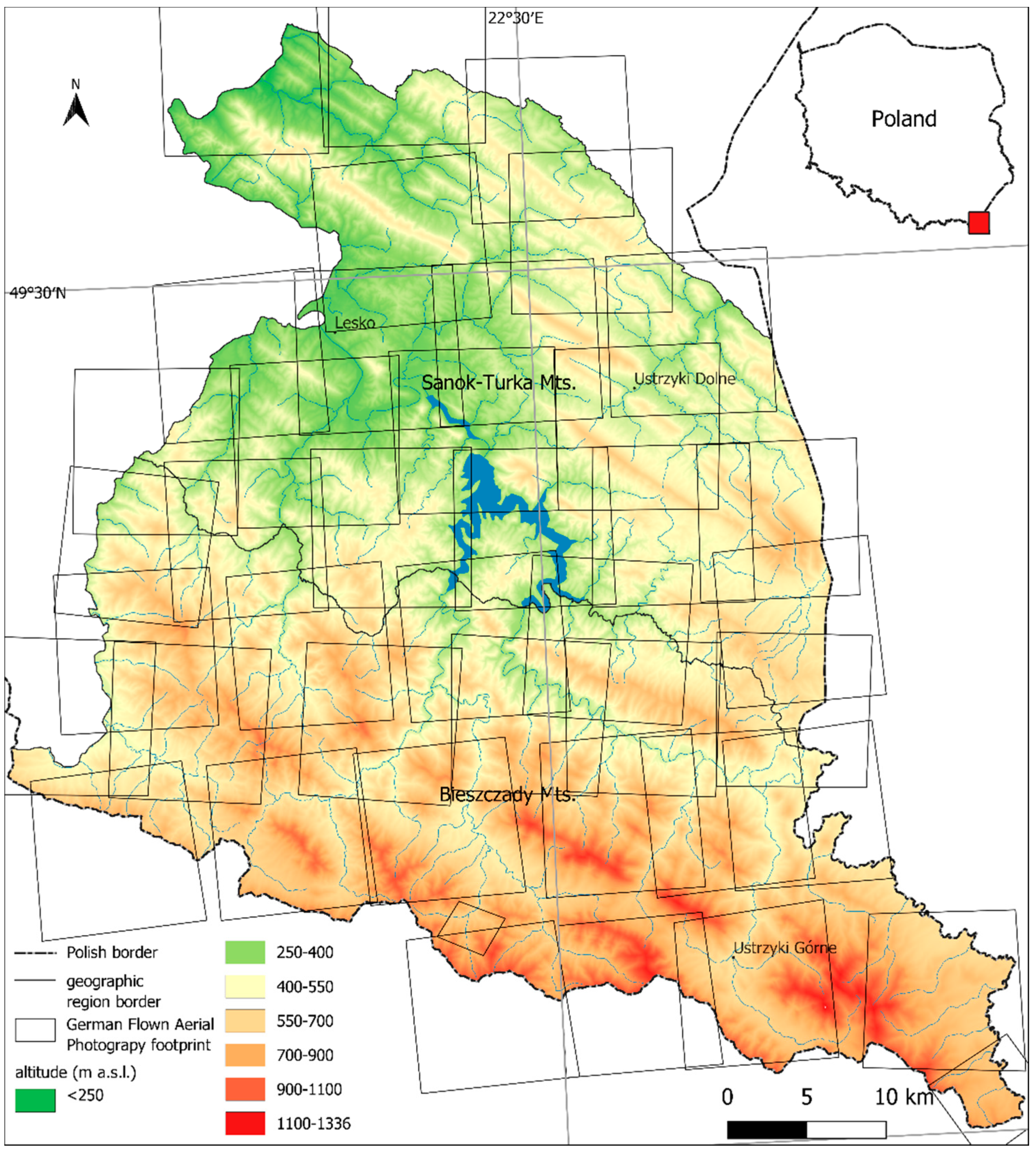
Figure 1. Study area—the Polish Eastern Carpathians with footprints of German Flown Aerial Photographs. Borders of geographic regions according to [37].
Remotesensing 13 02018 g001
Figure 2. Example of the German Flown Aerial Photography taken in 1944 obtained from NARA U.S. (a) and a Corona Image from 1969 obtained from USGS (b).
Remotesensing 13 02018 g002
Figure 3. Flowchart showing the processing of Corona images and German Flown Aerial Photographs.
Remotesensing 13 02018 g003
Figure 4. The map of post-agricultural forest and old-woods in the Polish Eastern Carpathians. Old-woods—forest that existed before 1944; mature post-agricultural forest—post-agricultural forest that developed before 1969; young post-agricultural forest—forest that developed after 1969; no data—missing aerial photos from 1944.
Remotesensing 13 02018 g004
Table 1. Remote sensing data used in this research.
DataSourceImage DateResolution
German Flown Aerial PhotographyNational Archives and Records Administration (NARA)July 1944~0.5 m
Corona U.S. Geological Survey25 September 19692.4 m
Sentinel-2U.S. Geological Survey1 July 201910 m
Publisher’s Note: MDPI stays neutral with regard to jurisdictional claims in published maps and institutional affiliations.