Assessment of the EUMETSAT Multi Decadal Land Surface Albedo Data Record from Meteosat Observations
Abstract
1. Introduction
2. Materials and Methods
2.1. Retrieval Algorithm
2.2. Release 2 Improvements
2.3. Cloud Removal
2.4. Conversion to Broadband Albedo
2.5. Albedo Data Record
2.6. Validation Datasets
- MODIS: The Moderate Resolution Imaging Spectroradiometer V006 MCD43A1 product containing daily L3 albedo values and BRDF parameters at 500 m resolution [7]. The data were downloaded from the ORNL DAAC Oak Ridge National Laboratory Distributed Active Archive Center with their global subset tool. The shortwave (0.3–5.0 μm) DHR30 is calculated from the BRDF parameters following the formula provided by the MODIS team (accessed on 18 May 2021) https://www.umb.edu/spectralmass/terra_aqua_modis/v006.
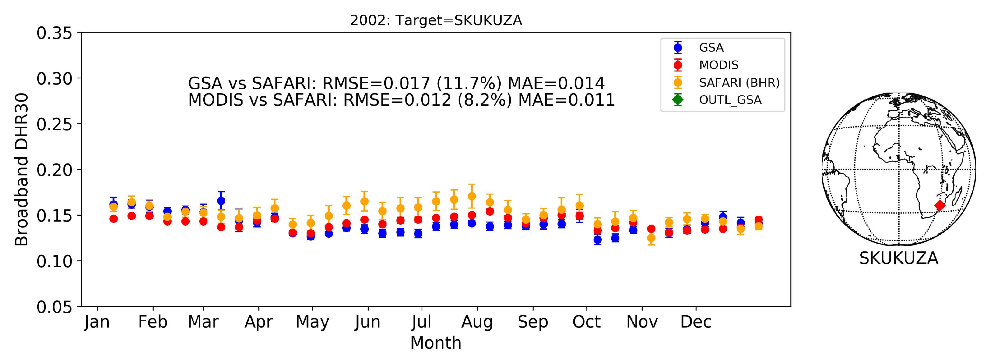
- SAFARI: Top-of-the-canopy broadband BHR (Blue Sky Albedo) [3] and radiation fluxes are calculated from measurements performed with flux tower on sites in southern Africa from a campaign conducted from March 2000 through December 2002 [34]. Where the blue-sky albedo refers to the albedo calculated under real-world conditions with a combination of both diffuse and direct lighting based on atmospheric and view-geometry conditions [35].
3. Results
3.1. Retrieval Consistency Assessment
3.2. Temporal Stability Analysis
3.3. Validation against Reference Dataset
4. Discussion
Author Contributions
Funding
Data Availability Statement
Acknowledgments
Conflicts of Interest
References
- WMO. GCOS, 92. Implementation Plan for the Global Observing System for Climate in Support of the UNFCCC; WMO/TD Nr. 1219; WMO: Geneva, Switzerland, 2004. [Google Scholar]
- Schaepman-Strub, G.; Schaepman, M.E.; Painter, T.H.; Dangel, S.; Martonchik, J.V. Reflectance quantities in optical remote sensing—definitions and case studies. Remote Sens. Environ. 2006, 103, 27–42. [Google Scholar] [CrossRef]
- Pinty, B.; Lattanzio, A.; Martonchik, J.V.; Verstraete, M.M.; Gobron, N.; Taberner, M.; Widlowski, J.L.; Dickinson, R.E.; Govaerts, Y. Coupling Diffuse Sky Radiation and Surface Albedo. J. Atmos. Sci. 2005, 62, 2580–2591. [Google Scholar] [CrossRef]
- Merchant, C.J.; Paul, F.; Popp, T.; Ablain, M.; Bontemps, S.; Defourny, P.; Hollmann, R.; Lavergne, T.; Laeng, A.; de Leeuw, G.; et al. Uncertainty information in climate data records from Earth observation. Earth Syst. Sci. Data 2017, 9, 511–527. [Google Scholar] [CrossRef]
- Schaaf, C.; Martonchik, J.; Pinty, B.; Govaerts, Y.; Gao, F.; Lattanzio, A.; Liu, J.; Strahler, A.; Taberner, M. Retrieval of Surface Albedo from Satellite Sensors. In Advances in Land Remote Sensing: System, Modeling, Inversion and Application; Springer: Dordrecht, The Netherlands, 2008. [Google Scholar]
- Liang, S.; Fang, H.; Chen, M.; Shuey, C.J.; Walthall, C.; Daughtry, C.; Morisette, J.; Schaaf, C.; Strahler, A. Validating MODIS land surface reflectance and albedo products: Methods and preliminary results. Remote Sens. Environ. 2002, 83, 149–162. [Google Scholar] [CrossRef]
- Schaaf, C.; Wang, Z. MCD43A1 MODIS/Terra+Aqua BRDF/Albedo Model Parameters Daily L3 Global—500 m V006. Available online: https://lpdaac.usgs.gov/products/mcd43a1v006/ (accessed on 13 April 2021).
- Chen, Y.; Liang, S.; Wang, J.; Kim, H.; Martonchik, J.V. Validation of MISR land surface broadband albedo. Int. J. Remote Sens. 2008, 29, 6971–6983. [Google Scholar] [CrossRef]
- Karlsson, K.G.; Riihelä, A.; Müller, R.; Meirink, J.F.; Sedlar, J.; Stengel, M.; Lockhoff, M.; Trentmann, J.; Kaspar, F.; Hollmann, R.; et al. CLARA-A1: A cloud, albedo, and radiation dataset from 28 yr of global AVHRR data. Atmos. Chem. Phys. 2013, 13, 5351–5367. [Google Scholar] [CrossRef]
- Karlsson, K.G.; Anttila, K.; Trentmann, J.; Stengel, M.; Meirink, J.F.; Devasthale, A.; Hanschmann, T.; Kothe, S.; Jääskeläinen, E.; Sedlar, J.; et al. CLARA-A2: CM SAF cLoud, Albedo and Surface RAdiation Dataset from AVHRR Dta—Edition 2. Available online: https://wui.cmsaf.eu/safira/action/viewDoiDetails?acronym=CLARA_AVHRR_V002 (accessed on 13 April 2021).
- Carrer, D.; Moparthy, S.; Lellouch, G.; Ceamanos, X.; Pinault, F.; Freitas, S.; Trigo, I. Land Surface Albedo Derived on a Ten Daily Basis from Meteosat Second Generation Observations: The NRT and Climate Data Record Collections from the EUMETSAT LSA SAF. Remote Sens. 2018, 10, 1262. [Google Scholar] [CrossRef]
- Govaerts, Y.M.; Lattanzio, A. Retrieval error estimation of surface albedo derived from geostationary large band satellite observations: Application to Meteosat-2 and Meteosat-7 data. J. Geophys. Res. Atmos. 2007, 112. [Google Scholar] [CrossRef]
- Pinty, B.; Roveda, F.; Verstraete, M.M.; Gobron, N.; Govaerts, Y.; Martonchik, J.V.; Diner, D.J.; Kahn, R.A. Surface albedo retrieval from Meteosat—1. Theory. J. Geophys. Res. Atmos. 2000, 105, 18099–18112. [Google Scholar] [CrossRef]
- Rahman, H.; Verstraete, M.M.; Pinty, B. Coupled surface-atmosphere reflectance (CSAR) model: 1. Model description and inversion on synthetic data. J. Geophys. Res. 1993, 98, 20779. [Google Scholar] [CrossRef]
- Lucht, W.; Schaaf, C.; Strahler, A. An algorithm for the retrieval of albedo from space using semiempirical BRDF models. IEEE Trans. Geosci. Remote Sens. 2000, 38, 977–998. [Google Scholar] [CrossRef]
- Maignan, F.; Bréon, F.M.; Lacaze, R. Bidirectional reflectance of Earth targets: Evaluation of analytical models using a large set of spaceborne measurements with emphasis on the Hot Spot. Remote Sens. Environ. 2004, 90, 210–220. [Google Scholar] [CrossRef]
- Lattanzio, A.; Fell, F.; Bennartz, R.; Trigo, I.F.; Schulz, J. Quality assessment and improvement of the EUMETSAT Meteosat Surface Albedo Climate Data Record. Atmos. Meas. Tech. 2015, 8, 4561–4571. [Google Scholar] [CrossRef]
- Govaerts, Y.M.; Arriaga, A.; Schmetz, J. Operational vicarious calibration of the MSG/SEVIRI solar channels. Adv. Space Res. 2001, 28, 21–30. [Google Scholar] [CrossRef]
- Govaerts, Y.; Clerici, M.; Clerbaux, N. Operational calibration of the Meteosat radiometer VIS band. IEEE Trans. Geosci. Remote Sens. 2004, 42, 1900–1914. [Google Scholar] [CrossRef]
- Stöckli, R.; Duguay–Tetzlaff, A.; Jedrzej, B.; Hollmann, R.; Fuchs, P.; Werscheck, M. CM SAF ClOud Fractional Cover dataset from METeosat First and Second Generation—Edition 1 (COMET Ed. 1). 2017. Available online: https://wui.cmsaf.eu/safira/action/viewDoiDetails?acronym=CFC_METEOSAT_V001 (accessed on 13 April 2021).
- Stöckli, R.; Bojanowski, J.S.; John, V.O.; Duguay-Tetzlaff, A.; Bourgeois, Q.; Schulz, J.; Hollmann, R. Cloud Detection with Historical Geostationary Satellite Sensors for Climate Applications. Remote Sens. 2019, 11, 1052. [Google Scholar] [CrossRef]
- Dee, D.P.; Uppala, S.M.; Simmons, A.J.; Berrisford, P.; Poli, P.; Kobayashi, S.; Andrae, U.; Balmaseda, M.A.; Balsamo, G.; Bauer, P.; et al. The ERA-Interim reanalysis: Configuration and performance of the data assimilation system. Q. J. R. Meteorol. Soc. 2011, 137, 553–597. [Google Scholar] [CrossRef]
- Lattanzio, A.; Govaerts, Y.M.; Pinty, B. Consistency of surface anisotropy characterization with meteosat observations. Adv. Space Res. 2007, 39, 131–135. [Google Scholar] [CrossRef]
- Diner, D.J.; Abdou, W.A.; Ackerman, T.P.; Crean, K.; Gordon, H.R.; Kahn, R.A.; Martonchik, J.V.; McMuldroch, S.; Paradise, S.R.; Pinty, B.; et al. Level 2 Aerosol Retrieval Algorithm Theoretical Basis; California Institute of Technology: Pasadena, CA, USA, 1997; p. 92. [Google Scholar]
- Lattanzio, A.; Schulz, J.; Matthews, J.; Okuyama, A.; Theodore, B.; Bates, J.J.; Knapp, K.R.; Kosaka, Y.; Schüller, L. Land Surface Albedo from Geostationary Satelites: A Multiagency Collaboration within SCOPE-CM. Bull. Am. Meteorol. Soc. 2012, 94, 205–214. [Google Scholar] [CrossRef]
- Pinty, B.; Roveda, F.; Verstraete, M.M.; Gobron, N.; Govaerts, Y.; Martonchik, J.V.; Diner, D.J.; Kahn, R.A. Surface albedo retrieval from Meteosat: 2. Applications. J. Geophys. Res. Atmos. 2000, 105, 18113–18134. [Google Scholar] [CrossRef]
- John, V.O.; Tabata, T.; Rüthrich, F.; Roebeling, R.; Hewison, T.; Stöckli, R.; Schulz, J. On the Methods for Recalibrating Geostationary Longwave Channels Using Polar Orbiting Infrared Sounders. Remote Sens. 2019, 11, 1171. [Google Scholar] [CrossRef]
- Loew, A.; Govaerts, Y. Towards Multidecadal Consistent Meteosat Surface Albedo Time Series. Remote Sens. 2010, 2, 957–967. [Google Scholar] [CrossRef]
- Govaerts, Y.; Pinty, B.; Taberner, M.; Lattanzio, A. Spectral conversion of surface albedo derived from meteosat first generation observations. IEEE Geosci. Remote Sens. Lett. 2006, 3, 23–27. [Google Scholar] [CrossRef]
- EUMETSAT. GSAR20000GSA Level 2 Climate Data Record Release 2—MFG and MSG—0 Degree. 2020. Available online: https://navigator.eumetsat.int/product/EO:EUM:DAT:0300 (accessed on 13 April 2021).
- EUMETSAT. GSAR20570GSA Level 2 Climate Data Record Release 2—MFG—57 Degree. 2020. Available online: https://navigator.eumetsat.int/product/EO:EUM:DAT:0301 (accessed on 13 April 2021).
- EUMETSAT. GSAR20630GSA Level 2 Climate Data Record Release 2—MFG—63 Degree. 2020. Available online: https://navigator.eumetsat.int/product/EO:EUM:DAT:0302 (accessed on 13 April 2021).
- Loew, A.; Bennartz, R.; Fell, F.; Lattanzio, A.; Doutriaux-Boucher, M.; Schulz, J. A database of global reference sites to support validation of satellite surface albedo datasets (SAVS 1.0). Earth Syst. Sci. Data 2016, 8, 425–438. [Google Scholar] [CrossRef]
- Privette, J.L.; Mukelabai, M.M.; Hanan, N.P.; Hao, Z. SAFARI 2000 Surface Albedo and Radiation Fluxes at Mongu and Skukuza, 2000–2002. ORNL DAAC 2005. [Google Scholar] [CrossRef]
- Potter, S.; Solvik, K.; Erb, A.; Goetz, S.J.; Johnstone, J.F.; Mack, M.C.; Randerson, J.T.; Román, M.O.; Schaaf, C.L.; Turetsky, M.R.; et al. Climate change decreases the cooling effect from postfire albedo in boreal North America. Glob. Chang. Biol. 2020, 26, 1592–1607. [Google Scholar] [CrossRef]
- Wang, P.; Knap, W.H.; Kuipers Munneke, P.; Stammes, P. Clear-sky shortwave radiative closure for the Cabauw Baseline Surface Radiation Network site, Netherlands. J. Geophys. Res. 2009, 114, D14206. [Google Scholar] [CrossRef]
- Cleveland, R.B.; Cleveland, W.S.; McRae, J.E.; Terpenning, I. STL: A Seasonal-Trend Decomposition Procedure Based on Loess. J. Off. Stat. (JOS) 1990, 6, 3–73. [Google Scholar]
- Iglewicz, B.; Hoaglin, D.C. How to Detect and Handle Outliers; Number v. 16 in ASQC Basic References in Quality Control; ASQC Quality Press: Milwaukee, WI, USA, 1993. [Google Scholar]
- Govaerts, Y.M.; Rüthrich, F.; John, V.O.; Quast, R. Climate Data Records from Meteosat First Generation Part I: Simulation of Accurate Top-of-Atmosphere Spectral Radiance over Pseudo-Invariant Calibration Sites for the Retrieval of the In-Flight Visible Spectral Response. Remote Sens. 2018, 10, 1959. [Google Scholar] [CrossRef]
- Quast, R.; Giering, R.; Govaerts, Y.; Rüthrich, F.; Roebeling, R. Climate Data Records from Meteosat First Generation Part II: Retrieval of the In-Flight Visible Spectral Response. Remote Sens. 2019, 11, 480. [Google Scholar] [CrossRef]
- Rüthrich, F.; John, V.O.; Roebeling, R.A.; Quast, R.; Govaerts, Y.; Woolliams, E.R.; Schulz, J. Climate Data Records from Meteosat First Generation Part III: Recalibration and Uncertainty Tracing of the Visible Channel on Meteosat-2–7 Using Reconstructed, Spectrally Changing Response Functions. Remote Sens. 2019, 11, 1165. [Google Scholar] [CrossRef]
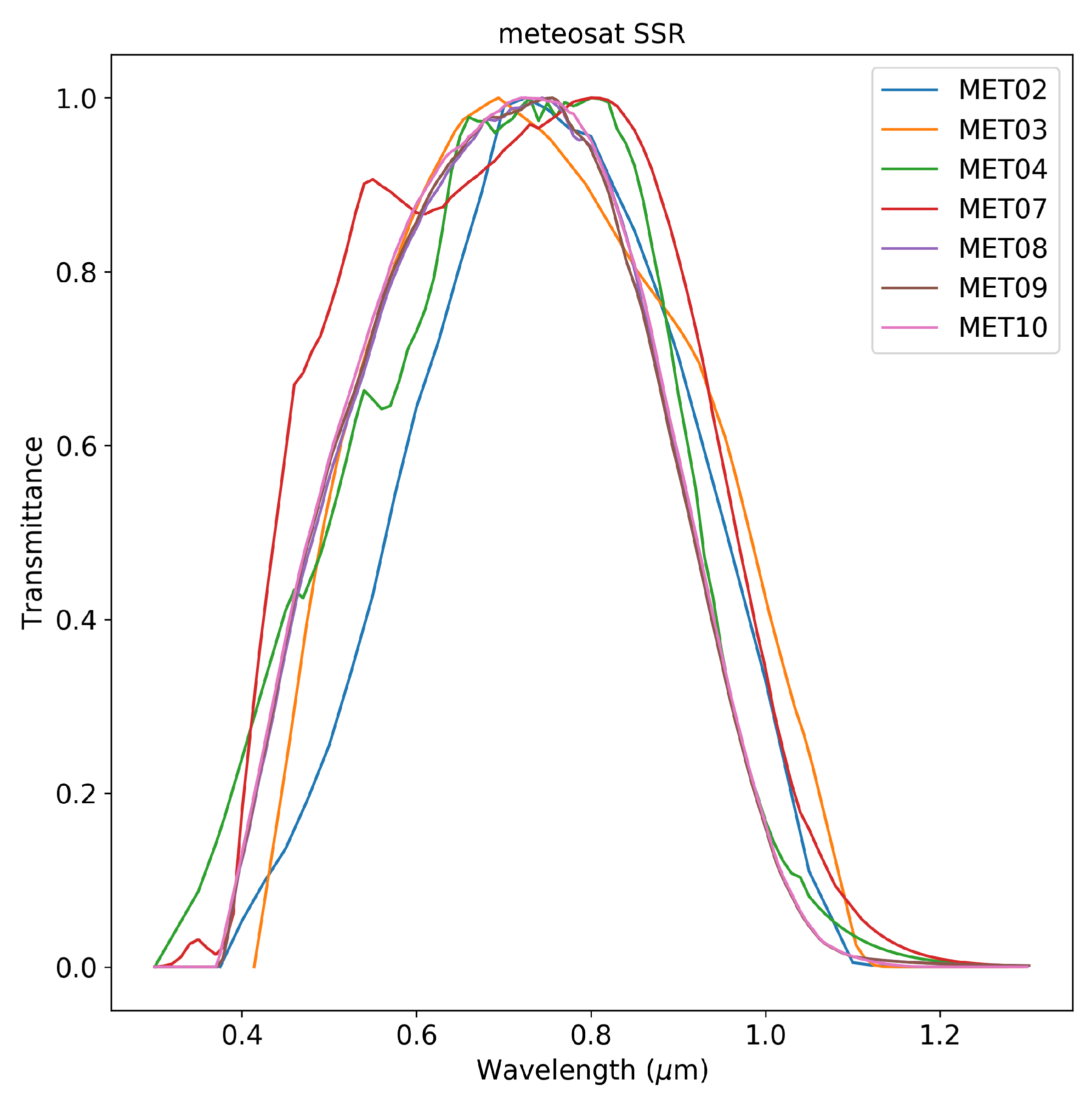

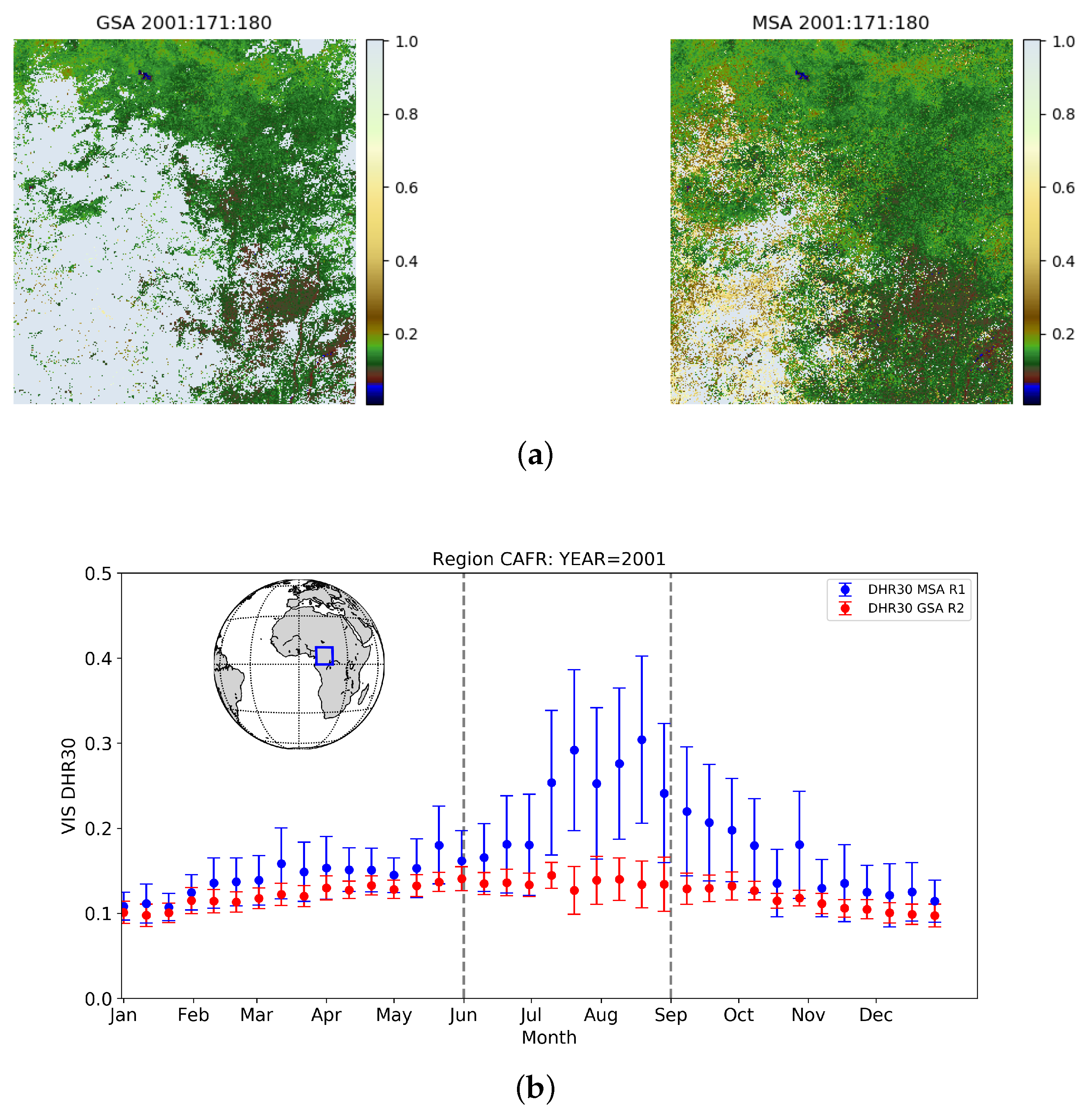
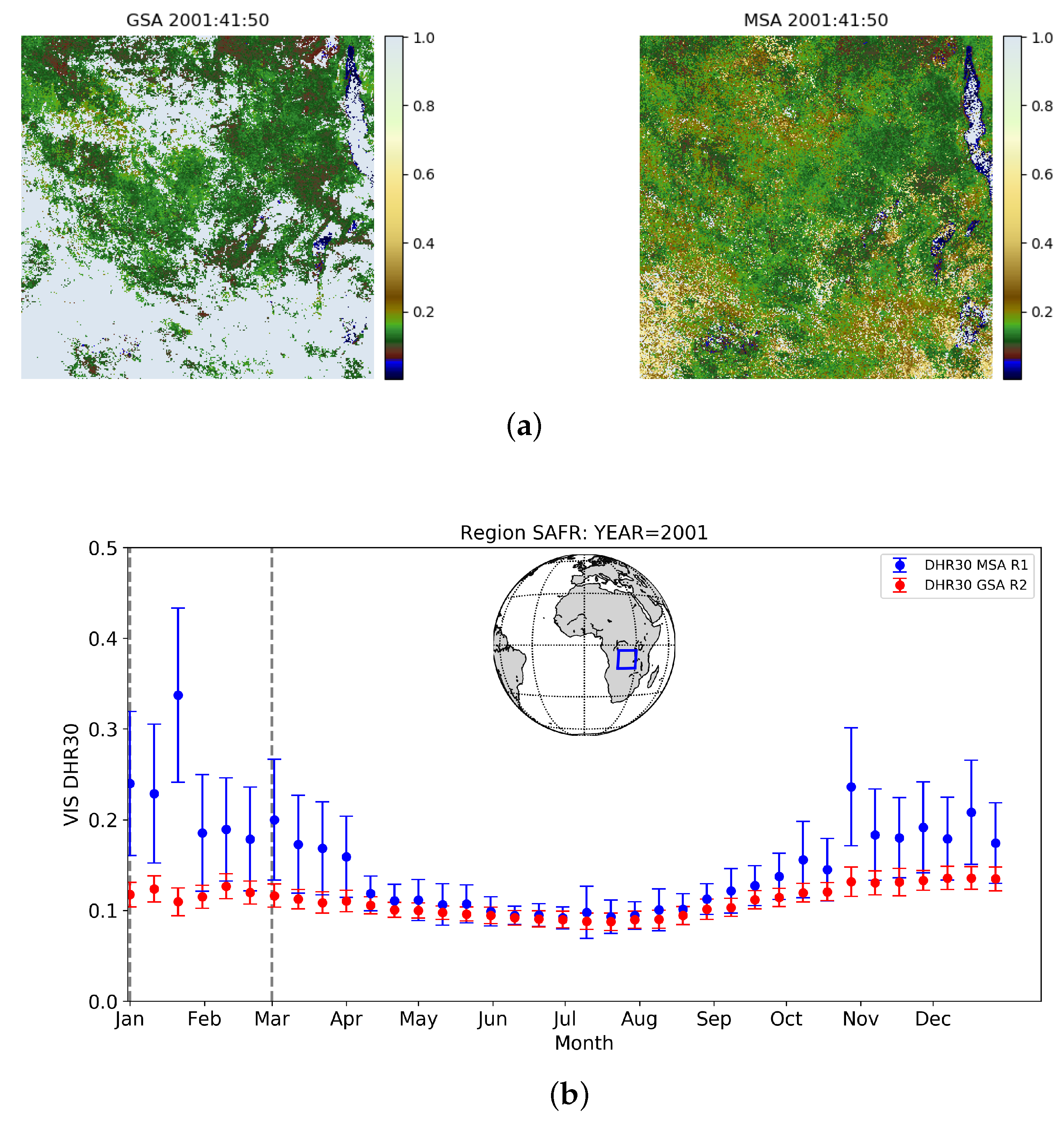
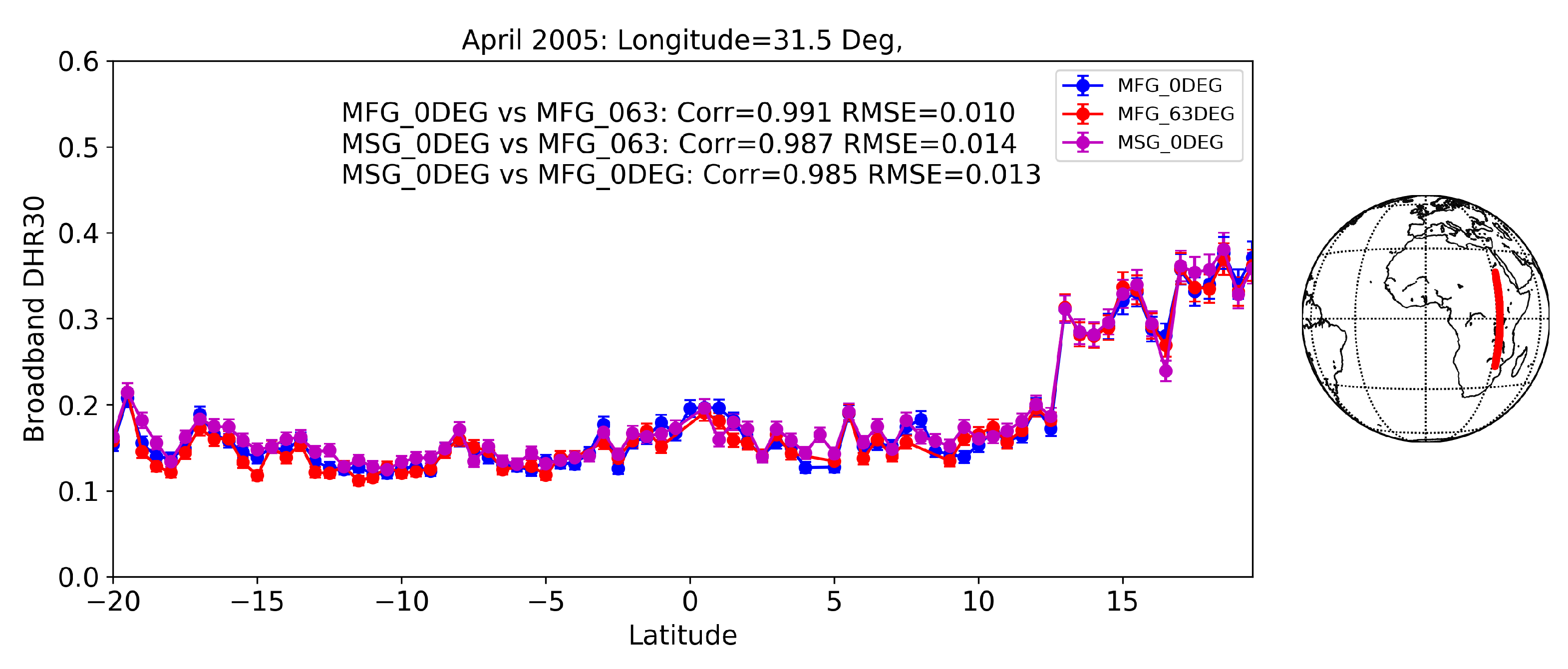


| Par | a | b | c | d | |
|---|---|---|---|---|---|
| Met | |||||
| 2 | 1.22636437 | −1.45464587 | 1.27798259 | ||
| 3 | 1.32036722 | −1.52968502 | 1.25365901 | ||
| 4 | 1.22655797 | −1.07426369 | 0.89601505 | ||
| 5 | 1.25341415 | −1.09384084 | 0.88984340 | ||
| 6 | 1.30573940 | −1.31526375 | 1.05711114 | ||
| 7 | 1.26273489 | −1.11476350 | 0.90094020 | ||
| 8 | 1.53323200 | −2.61389100 | 2.89949100 | ||
| 9 | 1.56889600 | −2.75666500 | 3.11088200 | ||
| 10 | 1.56626500 | −2.74375400 | 3.09211000 | ||
| Par | a | b | c | d | |
|---|---|---|---|---|---|
| Met | |||||
| 2 | 9.81895685 | −0.84840860 | 0.74379861 | ||
| 3 | 1.09896255 | −1.07471538 | 0.91173255 | ||
| 4 | 1.00361478 | −0.65500563 | 0.64731586 | ||
| 5 | 1.04928327 | −0.76641822 | 0.74790299 | ||
| 6 | 1.15992260 | −1.13301563 | 0.99891663 | ||
| 7 | 1.03751910 | −0.68823361 | 0.70061517 | ||
| 8 | 1.63337800 | −2.99600600 | 3.27934400 | ||
| 9 | 1.67045700 | −3.14845100 | 3.50383800 | ||
| 10 | 1.66796800 | −3.13584200 | 3.48480100 | ||
| Satellite | Instrument/Channel | Mission (SSP) | Start Date | End Date |
|---|---|---|---|---|
| Meteosat-2 | MVIRI/VIS | 0DEG (0) | 1982-02-10 | 1988-08-11 |
| Meteosat-3 | MVIRI/VIS | 0DEG (0) | 1988-08-11 | 1991-01-25 |
| Meteosat-4 | MVIRI/VIS | 0DEG (0) | 1989-06-19 | 1994-02-04 |
| Meteosat-5 | MVIRI/VIS | 0DEG (0) | 1991-05-02 | 1997-02-13 |
| IODC (63E) | 1998-07-01 | 2007-04-16 | ||
| Meteosat-6 | MVIRI/VIS | 0DEG (0) | 1996-10-21 | 2000-01-20 |
| Meteosat-7 | MVIRI/VIS | 0DEG (0) | 1998-06-03 | 2006-07-19 |
| IODC (57E) | 2006-11-01 | 2017-03-31 | ||
| Meteosat-8 | SEVIRI/HRV | 0DEG (0) | 2004-03-01 | 2007-05-31 |
| Meteosat-9 | SEVIRI/HRV | 0DEG (0) | 2007-05-01 | 2013-04-30 |
| Meteosat-10 | SEVIRI/HRV | 0DEG (0) | 2013-04-01 | 2017-12-31 |
| Site Name | Latitude (Degree North) | Longitude (Degree East) | Surface Type |
|---|---|---|---|
| LIBIA_00001 | 27.474 | 16.276 | Bare soil |
| EGYPT_ONE | 27.120 | 26.100 | Bare soil |
| SOV | 24.910 | 46.410 | Bare soil |
| MONGU | −15.254 | 23.151 | Urban |
| SKUKUZA | −25.020 | 31.483 | Shrubland |
| BELMANIP_00025 | −14.725 | −41.747 | Vegetation |
| Comparison | Correlation | MAE | RMSE |
|---|---|---|---|
| MFG_0DEG vs. MSG_0DEG | 0.99 | 0.010 | 0.013 |
| MFG_0DEG vs. MFG_IODC | 0.99 | 0.008 | 0.001 |
| MSG_0DEG vs. MFG_IODC | 0.99 | 0.012 | 0.014 |
| Site Name | Mean Trend Value | Decadal Trend (%) |
|---|---|---|
| SOV | 0.317 | 0.9 |
| LIBIA_00001 | 0.310 | −0.5 |
| MORZUQ_DESERT | 0.480 | 0.8 |
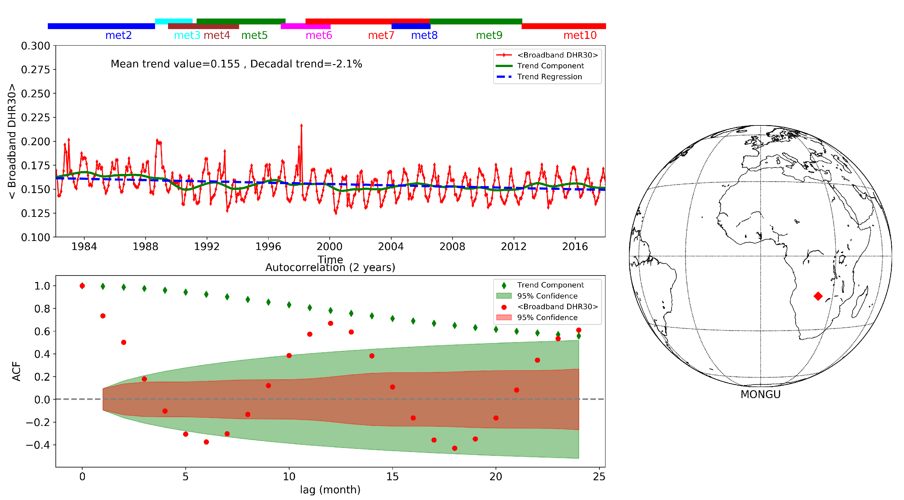
| MONGU | 0.155 | −2.1 |
| SKUKUZA | 0.149 | 0.2 |
| BELMANIP_00025 | 0.149 | −0.3 |
| Name | Year | Sat ID | AVG | SAMP | RMSE | PERC | MAE |
|---|---|---|---|---|---|---|---|
| LIBIA_00001 | 2001 | Meteosat-7 | 0.308 | 31 | 0.018 | 5.8 | 0.017 |
| 2005 | Meteosat-8 | 0.305 | 34 | 0.014 | 4.5 | 0.013 | |
| EGYPT_ONE | 2001 | Meteosat-7 | 0.455 | 37 | 0.009 | 2.0 | 0.008 |
| 2005 | Meteosat-8 | 0.461 | 32 | 0.013 | 2.9 | 0.011 | |
| SOV | 2001 | Meteosat-7 | 0.318 | 33 | 0.014 | 4.3 | 0.010 |
| 2001 | Meteosat-5 (IODC63) | 0.329 | 35 | 0.023 | 7.0 | 0.020 | |
| 2005 | Meteosat-8 | 0.320 | 36 | 0.014 | 4.3 | 0.011 | |
| 2007 | Meteosat-7 (IODC57) | 0.331 | 32 | 0.021 | 6.3 | 0.020 | |
| MONGU | 2001 | Meteosat-7 | 0.143 | 32 | 0.012 | 8.2 | 0.008 |
| SKUKUZA | 2002 | Meteosat-7 | 0.140 | 37 | 0.011 | 8.1 | 0.010 |
| BELMANIP_00025 | 2002 | Meteosat-7 | 0.122 | 23 | 0.010 | 8.9 | 0.009 |
| Name | Year | SAFARI | Sat ID | AVG | SAMP | RMSE | PERC | MAE |
|---|---|---|---|---|---|---|---|---|
| MONGU | 2001 | 0.166 | Meteosat-7 | 0.152 | 17 | 0.032 | 21.9 | 0.088 |
| MODIS | 0.143 | 18 | 0.030 | 20.8 | 0.024 | |||
| SKUKUZA | 2002 | 0.151 | Meteosat-7 | 0.140 | 36 | 0.019 | 11.7 | 0.014 |
| MODIS | 0.141 | 37 | 0.012 | 8.2 | 0.011 |
Publisher’s Note: MDPI stays neutral with regard to jurisdictional claims in published maps and institutional affiliations. |
© 2021 by the authors. Licensee MDPI, Basel, Switzerland. This article is an open access article distributed under the terms and conditions of the Creative Commons Attribution (CC BY) license (https://creativecommons.org/licenses/by/4.0/).
Share and Cite
Lattanzio, A.; Grant, M.; Doutriaux-Boucher, M.; Roebeling, R.; Schulz, J. Assessment of the EUMETSAT Multi Decadal Land Surface Albedo Data Record from Meteosat Observations. Remote Sens. 2021, 13, 1992. https://doi.org/10.3390/rs13101992
Lattanzio A, Grant M, Doutriaux-Boucher M, Roebeling R, Schulz J. Assessment of the EUMETSAT Multi Decadal Land Surface Albedo Data Record from Meteosat Observations. Remote Sensing. 2021; 13(10):1992. https://doi.org/10.3390/rs13101992
Chicago/Turabian StyleLattanzio, Alessio, Michael Grant, Marie Doutriaux-Boucher, Rob Roebeling, and Jörg Schulz. 2021. "Assessment of the EUMETSAT Multi Decadal Land Surface Albedo Data Record from Meteosat Observations" Remote Sensing 13, no. 10: 1992. https://doi.org/10.3390/rs13101992
APA StyleLattanzio, A., Grant, M., Doutriaux-Boucher, M., Roebeling, R., & Schulz, J. (2021). Assessment of the EUMETSAT Multi Decadal Land Surface Albedo Data Record from Meteosat Observations. Remote Sensing, 13(10), 1992. https://doi.org/10.3390/rs13101992


