Validation of Ash/Dust Detections from SEVIRI Data Using ACTRIS/EARLINET Ground-Based LIDAR Measurements

 ,
,  , , ,
, , , 
 ,
,  and
and
Abstract
1. Introduction
2. Methods
2.1. RST Detection Scheme
2.1.1. RSTASH Algorithm
2.1.2. The eRSTDUST Algorithm
2.2. EARLINET Ground-Based Lidar Measurements
3. Test Cases
3.1. Saharan Dust Events of May 2008
3.2. Eyjafjallajökull Ash Events of April–May 2010
4. Results
4.1. Validation of Dust Products of May 2008
4.2. Validation of RSTASH Detections of April–May 2010
5. Discussion
6. Conclusions
Author Contributions
Funding
Acknowledgments
Conflicts of Interest
References
- Wen, S.; Rose, W.I. Retrieval of sizes and total masses of particles in volcanic clouds using AVHRR bands 4 and 5. J. Geophys. Res. Atmos. 1994, 99, 5421–5431. [Google Scholar] [CrossRef]
- Herman, J.R.; Bhartia, P.K.; Torres, O.; Hsu, C.; Seftor, C.; Celarier, E. Global distribution of UV-absorbing aerosols from Nimbus 7/TOMS data. J. Geophys. Res. Atmos. 1997, 102, 16911–16922. [Google Scholar] [CrossRef]
- Gangale, G.; Prata, A.J.; Clarisse, L. The infrared spectral signature of volcanic ash determined from high-spectral resolution satellite measurements. Remote Sens. Environ. 2010, 114, 414–425. [Google Scholar] [CrossRef]
- Carlson, T.N.; Wendling, P. Reflected Radiance Measured by NOAA 3 VHRR as a Function of Optical Depth for Saharan Dust. J. Appl. Meteorol. 1977, 16, 1368–1371. [Google Scholar] [CrossRef]
- Robock, A.; Matson, M. Circumglobal transport of the El Chichón volcanic dust cloud. Science 1983, 221, 195–197. [Google Scholar] [CrossRef]
- Prata, A.J. Radiative transfer calculations for volcanic ash clouds. Geophys. Res. Lett. 1989, 16, 1293–1296. [Google Scholar] [CrossRef]
- Prata, A.J. Observations of volcanic ash clouds in the 10–12 µm window using AVHRR/2 data. Int. J. Remote Sens. 1989, 10, 751–761. [Google Scholar] [CrossRef]
- Zhang, P.; Lu, N.M.; Hu, X.Q.; Dong, C.H. Identification and physical retrieval of dust storm using three MODIS thermal IR channels. Glob. Planet Chang. 2006, 52, 197–206. [Google Scholar] [CrossRef]
- Webley, P.W.; Dehn, J.; Lovick, J.; Dean, K.G.; Bailey, J.E.; Valcic, L. Near-real-time volcanic ash cloud detection: Experiences from the Alaska Volcano Observatory. J. Volcanol. Geoth. Res. 2009, 186, 79–90. [Google Scholar] [CrossRef]
- Simpson, J.J.; Hufford, G.; Pieri, D.; Berg, J. Failures in detecting volcanic ash from a satellite-based technique. Remote Sens. Environ. 2000, 72, 191–217. [Google Scholar] [CrossRef]
- Mosher, F.R. Four channel volcanic ash detection algorithm. In Proceedings of the 10th Conference on Satellite Meteorology and Oceanography, Long Beach, CA, USA, 9–14 January 2000; pp. 457–460. [Google Scholar]
- Ellrod, G.P.; Connel, B.H.; Hillger, D.W. Improved detection of airborne volcanic ash using multi-spectral infrared satellite data. J. Geophys. Res. 2003, 108, 4356. [Google Scholar] [CrossRef]
- Pergola, N.; Tramutoli, V.; Marchese, F.; Scaffidi, I.; Lacava, T. Improving volcanic ash cloud detection by a robust satellite technique. Remote Sens. Environ. 2004, 90, 1–22. [Google Scholar] [CrossRef]
- Pavolonis, M.J.; Wayne, F.F.; Heidinger, A.K.; Gallina, G.M. A daytime complement to the reverse absorption technique for improved automated detection of volcanic ash. J. Atmos. Ocean. Technol. 2006, 23, 1422–1444. [Google Scholar] [CrossRef]
- Ackerman, S.A. Using the radiative temperature difference at 3.7 and 11 µm to track dust outbreaks. Remote Sens. Environ. 1989, 27, 129–133. [Google Scholar] [CrossRef]
- Wald, A.E.; Kaufman, Y.J.; Tanré, D.; Gao, B.C. Daytime and nighttime detection of mineral dust over desert using infrared spectral contrast. J. Geophys. Res. Atmos. 1998, 103, 32307–32313. [Google Scholar] [CrossRef]
- Francis, P.N.; Cooke, M.C.; Saunders, R.W. Retrieval of physical properties of volcanic ash using Meteosat: A case study from the 2010 Eyjafjallajökull eruption. J. Geophys. Res. Atmos. 2012, 117, 1–14. [Google Scholar] [CrossRef]
- Guéhenneux, Y.; Gouhier, M.; Labazuy, P. Improved space borne detection of volcanic ash for real-time monitoring using 3-Band method. J. Volcanol. Geotherm. Res. 2015, 293, 25–45. [Google Scholar] [CrossRef]
- Naeger, A.R.; Christopher, S.A. The identification and tracking of volcanic ash using the Meteosat Second Generation (MSG) Spinning Enhanced Visible and Infrared Imager (SEVIRI). Atmos. Meas. Tech. 2014, 7, 581–597. [Google Scholar] [CrossRef]
- Pavolonis, M.J.; Sieglaff, J.; Cintineo, J. Spectrally Enhanced Cloud Objects—A generalized framework for automated detection of volcanic ash and dust clouds using passive satellite measurements: 1. Multispectr. Anal. J. Geophys. Res. Atmos. 2015, 120, 7813–7841. [Google Scholar] [CrossRef]
- She, L.; Xue, Y.; Yang, X.; Guang, J.; Li, Y.; Che, Y.; Fan, C.; Xie, Y. Dust Detection and Intensity Estimation Using Himawari-8/AHI Observation. Remote Sens. 2018, 10, 490. [Google Scholar] [CrossRef]
- Albugami, S.; Palmer, S.; Meersmans, J.; Waine, T. Evaluating MODIS dust-detection indices over the Arabian Peninsula. Remote Sens. 2018, 10, 1993. [Google Scholar] [CrossRef]
- Singh, J.; Noh, Y.J.; Agrawal, S.; Tyagi, B. Dust Detection and Aerosol Properties Over Arabian Sea Using MODIS Data. Earth Syst. Environ. 2019, 3, 139–152. [Google Scholar] [CrossRef]
- Tramutoli, V. Robust satellite techniques (RST) for natural and environmental hazards monitoring and mitigation: Theory and applications. In Proceedings of the 2007 International Workshop on the Analysis of Multi-Temporal Remote Sensing Images, Leuven, Belgium, 18–20 July 2007. [Google Scholar] [CrossRef]
- Sannazzaro, F.; Filizzola, C.; Marchese, F.; Corrado, R.; Paciello, R.; Mazzeo, G.; Pergola, N.; Tramutoli, V. Identification of dust outbreaks on infrared MSG-SEVIRI data by using a Robust Satellite Technique (RST). Acta Astronaut. 2014, 93, 64–70. [Google Scholar] [CrossRef]
- Marchese, F.; Falconieri, A.; Pergola, N.; Tramutoli, V. A retrospective analysis of the Shinmoedake (Japan) eruption of 26–27 January 2011 by means of Japanese geostationary satellite data. J. Volcanol. Geotherm. Res. 2014, 269, 1–13. [Google Scholar] [CrossRef]
- Marchese, F.; Sannazzaro, F.; Falconieri, A.; Filizzola, C.; Pergola, N.; Tramutoli, V. An Enhanced Satellite-Based Algorithm for Detecting and Tracking Dust Outbreaks by Means of SEVIRI Data. Remote Sens. 2017, 9, 537. [Google Scholar] [CrossRef]
- Marchese, F.; Falconieri, A.; Pergola, N.; Tramutoli, V. Monitoring the Agung (Indonesia) Ash Plume of November 2017 by Means of Infrared Himawari 8 Data. Remote Sens. 2018, 10, 919. [Google Scholar] [CrossRef]
- Marchese, F.; Falconieri, A.; Filizzola, C.; Pergola, N.; Tramutoli, V. Investigating Volcanic Plumes from Mt. Etna Eruptions of December 2015 by Means of AVHRR and SEVIRI Data. Sensors 2019, 19, 1174. [Google Scholar] [CrossRef]
- Mona, L.; Pappalardo, G.; Amodeo, A.; D’Amico, G.; Madonna, F.; Boselli, A.; Giunta, A.; Russo, F.; Cuomo, V. One year of CNR-IMAA multi-wavelength Raman lidar measurements in coincidence with CALIPSO overpasses: Level 1 products comparison. Atmos. Chem. Phys. 2009, 9, 7213–7228. [Google Scholar] [CrossRef]
- Pappalardo, G.; Mona, L.; D’Amico, G.; Wandinger, U.; Adam, M.; Amodeo, A.; Ansmann, A.; Apituley, A.; Alados Arboledas, L.; Balis, D.; et al. Four-dimensional distribution of the 2010 Eyjafjallajökull volcanic cloud over Europe observed by EARLINET. Atmos. Chem. Phys. 2013, 13, 4429–4450. [Google Scholar] [CrossRef]
- Amiridis, V.; Kafatos, M.; Perez, C.; Kazadzis, S.; Gerasopoulos, E.; Mamouri, R.E.; Papayannis, A.; Kokkalis, P.; Giannakaki, E.; Basart, S.; et al. The Potential of the Synergistic Use of Passive and Active Remote Sensing Measurements for the Validation of a Regional Dust Model. Ann. Geophys. 2009, 27, 3155–3164. [Google Scholar] [CrossRef]
- Gudmundsson, M.T.; Pedersen, R.; Vogfjörd, K.; Thorbjarnardóttir, B.; Jakobsdóttir, S.; Roberts, M.J. Eruptions of Eyjafjallajökull Volcano, Iceland. Eos Trans. Am. Geophys. Union 2010, 91, 190–191. [Google Scholar] [CrossRef]
- Mona, L.; Amodeo, A.; D’Amico, G.; Giunta, A.; Madonna, F.; Pappalardo, G. Multi-wavelength Raman lidar observations of the Eyjafjallajökull volcanic cloud over Potenza, southern Italy. Atmos. Chem. Phys. 2012, 12, 2229–2244. [Google Scholar] [CrossRef]
- Falconieri, A.; Cooke, M.C.; Filizzola, C.; Marchese, F.; Pergola, N.; Tramutoli, V. Comparing Two Independent Satellite-Based Algorithms for Detecting and Tracking Ash Clouds by Using SEVIRI Sensor. Sensors 2018, 18, 369. [Google Scholar] [CrossRef] [PubMed]
- Cuomo, V.; Filizzola, C.; Pergola, N.; Pietrapertosa, C.; Tramutoli, V. A self-sufficient approach for Gerb cloudy radiance detection. Atmos. Res. 2004, 72, 39–56. [Google Scholar] [CrossRef]
- Marchese, F.; Malvasi, G.; Ciampa, M.; Filizzola, C.; Pergola, N.; Tramutoli, V. A robust multitemporal satellite technique for volcanic activity monitoring: Possible impacts on volcanic hazard mitigation. In Proceedings of the 2007 International Workshop on the Analysis of Multi-temporal Remote Sensing Images, Leuven, Belgium, 18–20 July 2007; pp. 1–5. [Google Scholar] [CrossRef]
- Piscini, A.; Corradini, S.; Marchese, F.; Merucci, L.; Pergola, N.; Tramutoli, V. Volcanic ash cloud detection from space: A comparison between the RSTASH technique and the water vapour corrected BTD procedure. Geomat. Nat. Hazards Risk 2011, 2, 263–277. [Google Scholar] [CrossRef]
- Marchese, F.; Filizzola, C.; Mazzeo, G.; Pergola, N.; Sannazzaro, F.; Tramutoli, V. Assessment and validation in time domain of a Robust Satellite Technique (RSTASH) for ash cloud detection. Geomat. Nat. Hazards Risk 2011, 2, 247–262. [Google Scholar] [CrossRef]
- A European Aerosol Research Lidar Network to Establish an Aerosol Climatology: EARLINET. Available online: https://www.earlinet.org/index.php?id=earlinet_homepage (accessed on 17 March 2020).
- Aerosol, Clouds and Trace Gases (ACTRIS). Available online: https://www.actris.eu/default.aspx (accessed on 17 March 2020).
- ACTRIS Data Center. Available online: https://actris.nilu.no/ (accessed on 17 March 2020).
- EARLINET Publishing Group 2000–2015: EARLINET VolcanicEruption 2000–2015; 2018 World Data Center for Climate (WDCC)–DKRZ (Deutsches Klimarechenzentrum); World Data Center for Climate (WDCC): Hamburg, Germany, 2018. [CrossRef]
- EARLINET Publishing Group 2000–2015: EARLINET SaharanDust 2000–2015; World Data Center for Climate (WDCC)–DKRZ (Deutsches Klimarechenzentrum); World Data Center for Climate (WDCC): Hamburg, Germany, 2018. [CrossRef]
- Mona, L.; Liu, Z.; Müller, D.; Omar, A.; Papayannis, A.; Sugimoto, N.; Pappalardo, G.; Vaughan, M. Lidar Measurements for Desert Dust Characterization: An Overview. Adv. Meteorol. 2012, 2012, 1–36. [Google Scholar] [CrossRef]
- Klein, H.; Nickovic, S.; Haunold, W.; Bundke, U.; Nillius, B.; Ebert, M.; Weinbruch, S.; Schuetz, L.; Levin, Z.; Barrie, L.A.; et al. Saharan dust and ice nuclei over Central Europe. Atmos. Chem. Phys. 2010, 10, 10211–10221. [Google Scholar] [CrossRef]
- Wiegner, M.; Groß, S.; Freudenthaler, V.; Schnell, F.; Gasteiger, J. The May/June 2008 Saharan dust event over Munich: Intensive aerosol parameters from lidar measurements. J. Geophys. Res. Atmos. 2011, 116, 1–15. [Google Scholar] [CrossRef]
- Tramutoli, V.; Marchese, F.; Falconieri, A.; Filizzola, C.; Genzano, N.; Hattori, K.; Lisi, M.; Liu, J.Y.; Ouzunov, D.; Parrot, M.; et al. Tropospheric and Ionospheric Anomalies Induced by Volcanic and Saharan Dust Events as Part of Geosphere Interaction Phenomena. Geosciences 2019, 9, 177. [Google Scholar] [CrossRef]
- Winker, D.M.; Liu, Z.; Omar, A.; Tackett, J.; Fairlie, D. CALIOP observations of the transport of ash from the Eyjafjallajökull volcano in April 2010. J. Geophys. Res. Atmos. 2012, 117, 1–12. [Google Scholar]
- Gudmundsson, M.T.; Thordarson, T.; Höskuldsson, Á.; Larsen, G.; Björnsson, H.; Prata, F.J.; Oddsson, B.; Magnússon, E.; Högnadóttir, T.; Petersen, G.N.; et al. Ash generation and distribution from the April-May 2010 eruption of Eyjafjallajökull, Iceland. Sci. Rep. 2012, 2, 572. [Google Scholar] [CrossRef]
- Bolic, T.; Sivcev, Z. Eruption of Eyjafjallajökull in Iceland: Experience of European Air Traffic Management. Transp. Res. Rec. 2013, 2214, 136–143. [Google Scholar] [CrossRef]
- Gislason, S.R.; Hassenkam, T.; Nedel, S.; Bovet, N.; Eiriksdottir, E.S.; Alfredsson, H.A.; Hem, C.P.; Balogh, Z.I.; Dideriksen, K.; Oskarsson, N.; et al. Characterization of Eyjafjallajökull volcanic ash particles and a protocol for rapid risk assessment. Proc. Natl. Acad. Sci. USA 2011, 108, 7307–7312. [Google Scholar] [CrossRef] [PubMed]
- Langmann, B.; Folch, A.; Hensch, M.; Matthias, V. Volcanic ash over Europe during the eruption of Eyjafjallajökull on Iceland, April–May 2010. Atmos. Environ. 2012, 48, 1–8. [Google Scholar] [CrossRef]
- Woodhouse, M.J.; Hogg, A.J.; Phillips, J.C.; Sparks, R.S.J. Interaction between volcanic plumes and wind during the 2010 Eyjafjallajökull eruption, Iceland. J. Geophys. Res. Soild Earth 2013, 118, 92–109. [Google Scholar] [CrossRef]
- Stohl, A.; Prata, A.J.; Eckhardt, S.; Clarisse, L.; Durant, A.; Henne, S.; Kristiansen, N.I.; Minikin, A.; Schumann, U.; Seibert, P.; et al. Determination of time- and height-resolved volcanic ash emissions and their use for quantitative ash dispersion modeling: The 2010 Eyjafjallajökull eruption. Atmos. Chem. Phys. 2011, 11, 4333–4351. [Google Scholar] [CrossRef]
- Mona, L.; Papagiannopoulos, N.; Basart, S.; Baldasano, J.; Binietoglou, I.; Cornacchia, C.; Pappalardo, G. EARLINET dust observations vs. BSC-DREAM8b modeled profiles: 12-year-long systematic comparison at Potenza, Italy. Atmos. Chem. Phys. 2014, 14, 8781–8793. [Google Scholar] [CrossRef]


| Satellite Data | Location | Algorithm | Mean Layer β532 (10−6 m−1 sr−1) | Layer Integrated β532 (sr−1) | Aerosol Type | Bottom-Top Height (km a.s.l.) |
|---|---|---|---|---|---|---|
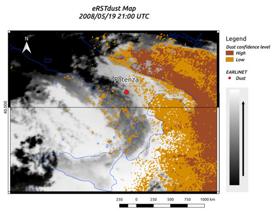
| 19/05/2008-21:00 UTC | Potenza | eRSTDUST | 3.7 ± 0.9 | 0.0060 | Mixed dust | 1.4–3.3 |
| 20/05/2008-08:45 UTC | Thessaloniki | eRSTDUST | 3.5 ± 0.1 | 0.0029 | Mixed dust | 1.4–3.3 |
| 20/05/2008-08:45 UTC | Sofia | eRSTDUST | 1.2 ± 1.1* | 0.0032 | Mixed dust | 1.6–4.3 |
| 16/04/2010-06:00 UTC | Hamburg | RSTASH | 6.0 ± 4.5 | 0.0258 | Ash | 0.7–5.2 |
| 17/05/2010-18:00 UTC | Cabauw | RSTASH | 1.9 ± 1.3 | 0.0030 | Ash | 3.0–5.5 |
| 18/05/2010-12:00 UTC | Cabauw | RSTASH | 0.2 ± 0.4 | 0.0014 | Ash | 1.6–5.9 |
| 18/05/2010-12:00 UTC | Ispra | RSTASH | 1.5 ± 1.5 | 0.0088 | Ash | 2.2–8.6 |
| Satellite Data | Location | Mean Layer β532 (10−6 m−1 sr−1) | Layer Integrated β532 (sr−1) | Aerosol Type | Bottom-Top Height (km a.s.l) | Issue |
|---|---|---|---|---|---|---|
| 18/05/2008-10:00 UTC | Potenza | 1.9 ± 1.0 | 0.0020 | Mixed dust | 1.8–2.8 | Clouds |
| 18/05/2008-21:00 UTC | Potenza | 1.5 ± 0.7 | 0.0051 | Mixed dust | 1.4–4.8 | Clouds |
| 16/04/2010-06:00 UTC | Payerne | 0.4 ± 0.1 | 0.0005 | Ash | 0.7–5.2 | Plume features |
| 17/05/2010-18:00 UTC | Hamburg | 0.6 ± 0.5 | 0.0021 | Ash | 1.2–4.9 | Plume features |
© 2020 by the authors. Licensee MDPI, Basel, Switzerland. This article is an open access article distributed under the terms and conditions of the Creative Commons Attribution (CC BY) license (http://creativecommons.org/licenses/by/4.0/).
Share and Cite
Falconieri, A.; Papagiannopoulos, N.; Marchese, F.; Filizzola, C.; Trippetta, S.; Pergola, N.; Pappalardo, G.; Tramutoli, V.; Mona, L. Validation of Ash/Dust Detections from SEVIRI Data Using ACTRIS/EARLINET Ground-Based LIDAR Measurements. Remote Sens. 2020, 12, 1172. https://doi.org/10.3390/rs12071172
Falconieri A, Papagiannopoulos N, Marchese F, Filizzola C, Trippetta S, Pergola N, Pappalardo G, Tramutoli V, Mona L. Validation of Ash/Dust Detections from SEVIRI Data Using ACTRIS/EARLINET Ground-Based LIDAR Measurements. Remote Sensing. 2020; 12(7):1172. https://doi.org/10.3390/rs12071172
Chicago/Turabian StyleFalconieri, Alfredo, Nikolaos Papagiannopoulos, Francesco Marchese, Carolina Filizzola, Serena Trippetta, Nicola Pergola, Gelsomina Pappalardo, Valerio Tramutoli, and Lucia Mona. 2020. "Validation of Ash/Dust Detections from SEVIRI Data Using ACTRIS/EARLINET Ground-Based LIDAR Measurements" Remote Sensing 12, no. 7: 1172. https://doi.org/10.3390/rs12071172
APA StyleFalconieri, A., Papagiannopoulos, N., Marchese, F., Filizzola, C., Trippetta, S., Pergola, N., Pappalardo, G., Tramutoli, V., & Mona, L. (2020). Validation of Ash/Dust Detections from SEVIRI Data Using ACTRIS/EARLINET Ground-Based LIDAR Measurements. Remote Sensing, 12(7), 1172. https://doi.org/10.3390/rs12071172