Abstract
Significant water quality changes have been observed in the Dongting Lake region due to environmental changes and the strong influence of human activities. To protect and manage Dongting Lake, the long-term dynamics of the water surface and algal bloom areas were systematically analyzed and quantified for the first time based on 17 years of Moderate Resolution Imaging Spectroradiometer (MODIS) observations. The traditional methods (index-based threshold algorithms) were optimized by a dynamic learning neural network (DL-NN) to extract and identify the water surface area and algal bloom area while reducing the extraction complexity and improving the extraction accuracy. The extraction accuracy exceeded 94.5% for the water and algal bloom areas, and the analysis showed decreases in the algal bloom and water surface areas from 2001–2017. Additionally, the variations in the water surface and algal bloom areas are greatly affected by human activities and climatic factors. The results of these analyses can help us better monitor human contamination in Dongting Lake and take measures to control the water quality during certain periods, which is crucial for future management. Moreover, the traditional methods optimized by the DL-NN used in this study can be extended to other inland lakes to assess and monitor long-term temporal and spatial variations in algal bloom areas and can also be used to acquire baseline information for future assessments of the water quality of lakes.
1. Introduction
Lakes, which not only enable shipping and supply water resources for human consumption but also improve the local microclimate and ecological environment, represent one of the most important components of the hydrosphere [1,2]. However, lakes are very sensitive to climate change and human factors [3,4,5]. As a result, due to intensive human activities and climate change in recent years, many lakes have decreased in size [6,7,8,9], and as a consequence, nearly half of all lakes worldwide experience eutrophication [10]. Excessive cyanobacterial growth, water quality deterioration, and lake shrinkage have resulted in significant losses to the landscape, economy, and ecology in some regions [11,12,13,14]. Thus, accurate monitoring of the water surface area and algal blooms is essential for protecting the ecological environment and human health.
Data from remote sensing satellites, such as AVHRR, MODIS, MERIS, and Landsat, have been used extensively for mapping surface water [15,16,17]. Various methods have been proposed to identify water information from remote sensing imagery [18,19,20,21]; these techniques can be divided into three main types. The first type of method is the threshold approach, which is based on a related water body index, such as the normalized difference water index (NDWI) [22], the modified normalized difference water index (MNDWI) [23], and the automated water extraction index (AWEI) [24]. These indexes, based on the spectral curves of water bodies, utilize thresholds to effectively distinguish water bodies from non-water bodies. However, it is very difficult to obtain an ideal single threshold because the spectral signature of water varies under different conditions [25]; moreover, various dynamic or variational threshold methods, such as Otsu’s method [26], have been adapted to determine the optimal values of these thresholds. The second type of method is supervised classification based on prior knowledge; examples include the support vector machine (SVM), decision tree, logical regression [27], and random forest [28] methods. Supervised classification methods are based on prior knowledge and require numerous training samples for computer learning. The third type of method involves a water-specific classification; these methods include expert systems [29] and spectrum matching based on discrete particle swarm optimization (SMDPSO) [30]. This approach is more automated and accurate than general supervised classification [4]. In addition, some studies have also used synthetic aperture radar (SAR) data to monitor the dynamics of surface water because these data are insensitive to clouds and independent of the illumination conditions [31,32,33,34,35]; the extent of surface water can be extracted from SAR data based mainly on textural analysis [36], change detection [37], automatic segmentation [38] and classification [39].
Nevertheless, it is exceedingly difficult to accurately monitor real-time algal blooms based on traditional in situ sampling and laboratory analysis methods because the distributions of algal blooms vary dynamically with both time and space. Compared with traditional in situ measurement methods, remote sensing technology boasts a variety of advantages, that is, its large-scale and dynamic monitoring potential and its ability to acquire reliable information regarding the extent of algal blooms on the water surface [40,41,42]. In recent decades, advances in satellite sensor design technology and developments in related algorithms have made it possible to apply remote sensing to accurately monitor algae blooms in various ecosystems (coastal waters and lakes) [43,44,45]. However, because radar beams cannot penetrate the water surface, it remains challenging to utilize radar beams to quantitatively estimate the extent of cyanobacteria [46]. As an alternative, some scholars combined optical and SAR images to detect cyanobacteria blooms and the formation of scum and concluded that the combination of optical and microwave signals can better explain the occurrence of cyanobacteria blooms [47]. Most scholars have mapped algal blooms using optical remote sensing data [48,49]; accordingly, algal blooms are detected using either indirect methods using water quality parameters (e.g., transparency) [50] or direct methods based on spectral curve characteristics [51] and photosynthetic pigment concentrations (chlorophyll-a, phycoerythrin and phycocyanin) [52,53]. Algorithms utilizing chlorophyll-a concentrations encounter problems when thick foams and complex chemical constituents are present in a body of water [47]. To overcome these shortcomings, many new algorithms have been proposed. Based on the response of the near-infrared (NIR) band to algal blooms, algorithms that use NIR band information, such as single-band algorithms [54,55,56], spectral band difference algorithms [57], reflectance band ratio algorithms [58,59], and land surface vegetation detection algorithms [60,61], have shown particular promise. In addition, spectral shape algorithms based on the NIR band have also been used; examples include the classification and regression tree (CART) [62], floating algae index (FAI) [63,64,65], maximum peak height (MPH) [66], fluorescent line height (FLH) [67,68,69] and maximum chlorophyll index (MCI) [70,71] algorithms.
Dongting Lake, the second largest freshwater lake in China, serves as a primary drinking-water source for 11.55 million people in some cities in Hunan province as well as the Jingzhou city in Hubei Province (Comprehensive Treatment Plan for Dongting Lake Water Environment, https://www.ndrc.gov.cn/xxgk/zcfb/tz/201812/t20181206_962335.html). This lake represents an important regional fishery and tourism resource; correspondingly, the existence and stability of the lake play irreplaceable roles in the development of the regional economy and the balance of the regional environment. However, due to intensified human activities and climate change, the occurrence of algal blooms and the reduction in the water surface area have considerably impacted Dongting Lake and its surrounding environment [72,73,74,75,76]. Additionally, these factors have limited the supply of freshwater to the surrounding population [77,78]. Therefore, to protect the ecological environment of Dongting Lake and ensure the safe supply of drinking water for the surrounding residents, we use a dynamic learning neural network (DL-NN) to optimize the traditional methods (that is, index-based threshold algorithms) to extract the water surface area and identify the extents of algal blooms more concisely and accurately and thereby perform systematic research to analyze their spatiotemporal changes. The objectives of this study were to (1) accurately extract and validate the areal extents of the water surface area of Dongting Lake and the algal blooms therein, (2) analyze the spatial and temporal trends of the water surface area and algal bloom outbreaks in Dongting Lake, (3) explore the reasons for the changes in the lake water surface area and algal bloom areas in Dongting Lake, and (4) propose effective measures to control and improve the water quality.
2. Materials and Methods
2.1. Study Area
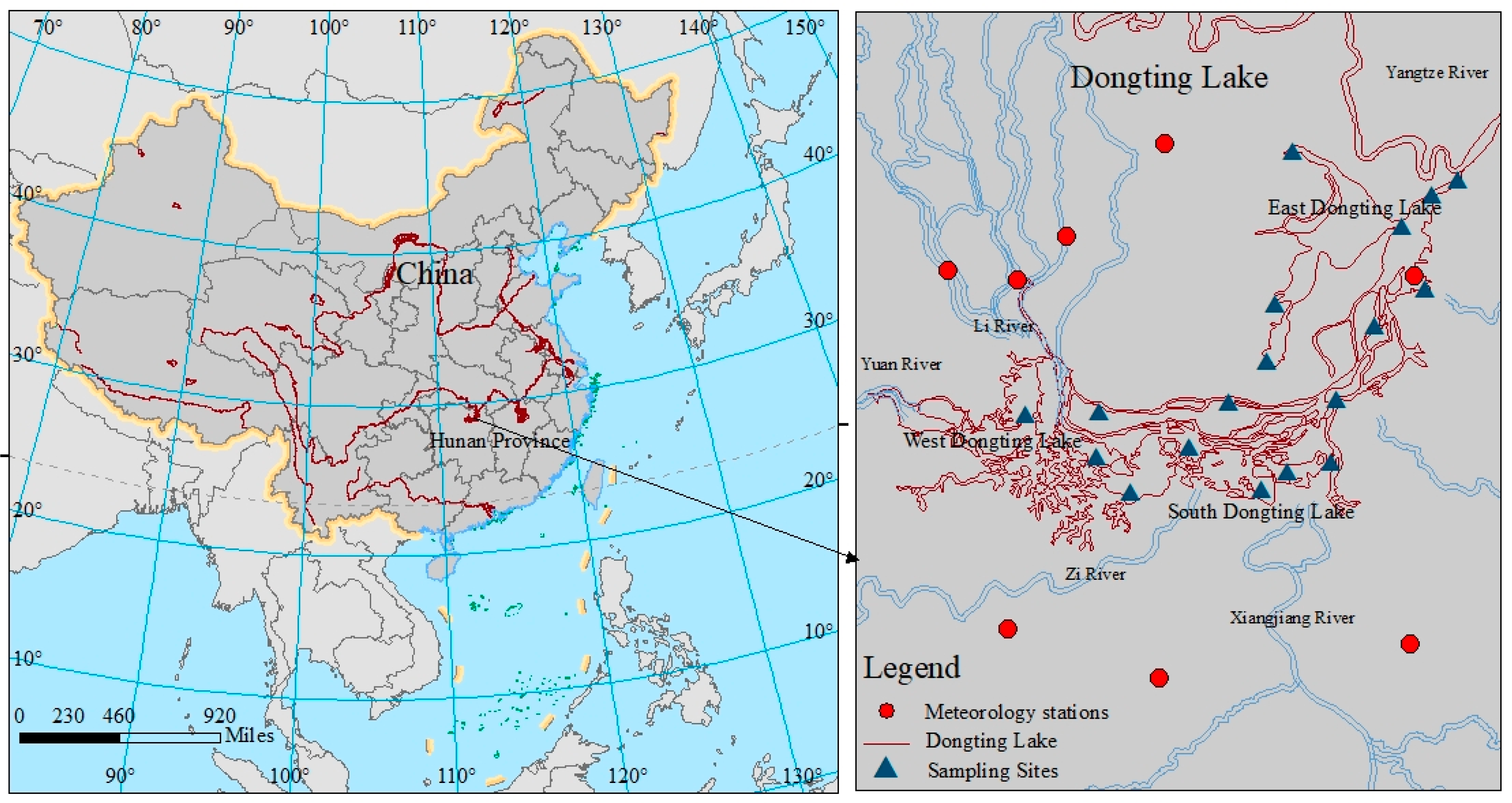
Dongting Lake (111°40′E ~ 113°10′E, 28°30′N ~ 30°20′N), the second largest freshwater lake in China, has a drainage area of approximately 262,800 km2 and an average water depth of 6.39 m. The lake is located in the middle and lower reaches of the Yangtze River Basin in northeastern Hunan Province (Figure 1). The topography of the land surrounding the lake is high in the west and low in the east, and the lake can be divided into eastern, western and southern sections. Dongting Lake is adjacent to the Yangtze River to the north and four rivers (the Xiangjiang River, Zi River, Yuan River, and Li River) to the south, all of which run through Chenglingji and part of Yueyang and finally drain into the Yangtze River.
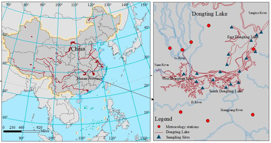
Figure 1.
Location of the study area.
The Dongting Lake Basin is one of the most industrialized regions in China and is surrounded by Yueyang, Yiyang, Yuanjiang, Changde and other important cities in Hunan Province, as well as many prefecture-level counties and cities with strong economic development, such as Xiangyin and Nan Counties. The population density is high in this area (about 22.24 million people in 2017), and economic development has been rapid, which has affected the water surface area and quality of Dongting Lake (Bi et al., 2018). Consequently, the ecological environment of Dongting Lake has deteriorated, and the eutrophication trend of the lake has worsened. In particular, algal bloom outbreaks occurred in the eastern part of Dongting Lake in 2005–2006. According to statistics from the State Environmental Protection Administration, the overall water quality of Dongting Lake reached grade V in 2005 (National Surface Water Quality Standard GB3838-2002), where a higher grade corresponds to a worse water quality. At the end of 2007, Hunan Province strengthened the water quality protection standards for Dongting Lake and investigated the enterprises around the lake; as a result, more than 200 businesses were penalized to prevent them from introducing additional pollution into the lake. Subsequently, the water quality of Dongting Lake has gradually improved. Nevertheless, although the water quality of Dongting Lake reached grade IV following these actions (GB3838-2002), the water pollution in Dongting Lake increased from 2007 to 2008. Then, at the end of 2014, the Dongting Lake water quality further deteriorated coincident with increasing eutrophication, reaching a water quality worse than grade V (GB3838-2002). In particular, the phosphorus content in the water greatly exceeded the national standards (GB3838-2002). Therefore, to protect the local water quality and ensure the safe supply of drinking water for the surrounding residents, it is necessary to monitor the changes in water quality in real time.
2.2. Materials
2.2.1. MODIS and Landsat Data
MODIS is an earth observation system (EOS) instrument that has 36 bands, and the Landsat Enhanced Thematic Mapper Plus (ETM+) sensor has 8 bands with a high spatial resolution. MODIS and ETM+ data are particularly useful because of their global coverage, radiometric resolution, dynamic ranges, and free availability.
In this study, MODIS L1B data were used primarily to extract the water surface and algal bloom areas for Dongting Lake, while 30-m-resolution Landsat 7 ETM+ data were used to validate the MODIS observations. MODIS data acquired by both the Terra satellite and the Aqua satellite over the period from January 2001 to February 2018 were obtained from https://ladsweb.modaps.eosdis.nasa.gov/, and Landsat 7 ETM+ data were obtained from https://earthexplorer.usgs.gov/. Due to the 16-day revisit frequency of Landsat 7, only a few Landsat scenes with 0–20% cloud cover over Dongting Lake were obtained.
We selected 1070 images with low cloud cover over the Dongting Lake area in spring (March, April, and May), summer (June, July, and August), autumn (September, October, and November), and winter (December, January, and February) from 2001–2017; the dataset included 1059 MODIS images from both Terra and Aqua and 11 Landsat 7 ETM+ images.
2.2.2. In Situ Data Acquisition
Water level data were used to verify the accuracy of the extracted water surface areas because the surface area and water level are highly correlated. These data comprising daily measured water level data from 2001 to 2017 were derived from the Chenglingji hydrological station. In this study, water level data corresponding to the dates of the remote sensing images are the primary source for validation.
Precipitation and temperature data (2001–2017) from eight stations (Yueyang, Huarong, Anxiang, Yuanjiang, Xiangyin, Guluo, Jianli, and Nanxian) around Dongting Lake were acquired from the China Meteorological Administration (http://www.cma.gov.cn/2011qxfw/2011qsjgx/). The location of each meteorological station is shown in Figure 1. These data were used to analyze the effects of precipitation and temperature on the water surface and algal bloom areas in Dongting Lake. The temperature and precipitation data used in this study are the average values from these stations.
The annual mean runoff and annual mean sediment data (1999–2017) from nine stations (Xiangtan, Taojiang, Taoyuan, Shimen, Xinjiangkou, Shadaoguan, Mituosi, Kangjiagang and Guanjiapu) around Dongting Lake were acquired from the Changjiang (Yangtze) Sediment Bulletin at http://www.cjw.gov.cn/zwzc/bmgb/. These data were used to analyze the causes of the changes in the water surface area.
Field investigations were performed monthly at predefined sites across Lake Dongting from 2001 to 2017 to obtain (1) manual outlines of the area where known aquatic macrophytes exist based on field observations and (2) field observations of nutrients (including total nitrogen (TN) and total phosphorus (TP)) and of chlorophyll-a (Chl-a concentration ≥0.01 mg/L, at which algal blooms accumulate on the surface of the water). These data were used to modify the extraction results of the Landsat 7 ETM+ and MODIS images because the algal blooms depended significantly on variations in the TN and TP concentrations [79].
2.3. Methods
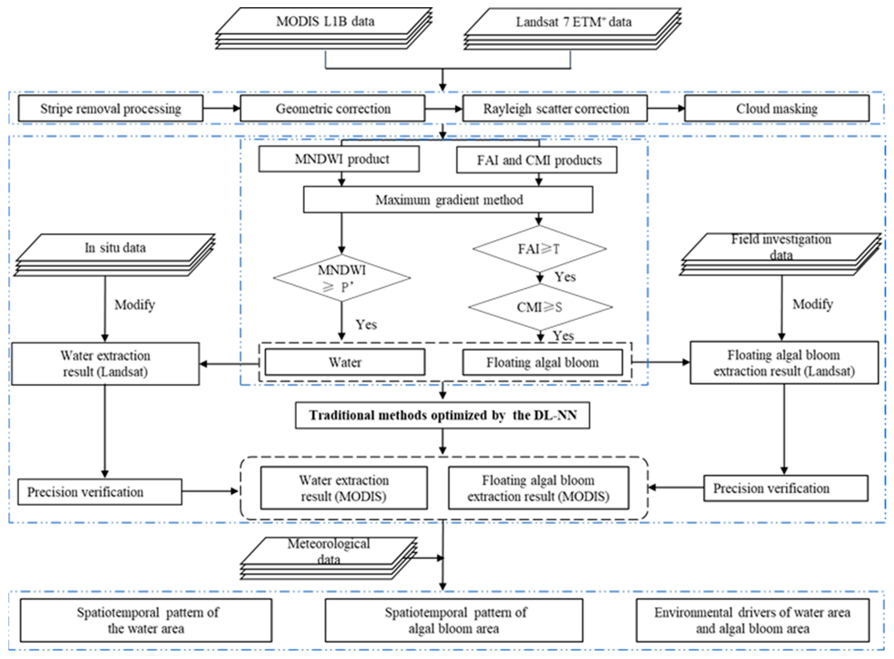
The overall methodology is illustrated in Figure 2. We performed Rayleigh correction for the MODIS and Landsat data to generate Rayleigh-corrected reflectance (Rrc); then, traditional methods were used to extract and identify the extents of the surface water and algal blooms. More specifically, time series of the FAI, cyanobacteria and macrophyte index (CMI), and MNDWI products were generated, and the maximum gradient method was used to obtain the threshold employed to extract and identify them. Second, we used the DL-NN to optimize the traditional methods to extract and identify the water surface and algal bloom areas more concisely and accurately. After verifying the extraction accuracy, we analyzed the dynamic changes in the water area and algal blooms throughout Dongting Lake. More details are given in the following sections.
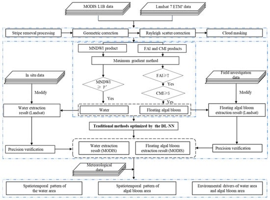
Figure 2.
Diagram of the overall methodology used in this study.
2.3.1. Remote Sensing Data Processing
The MODIS L1B data were destriped using the National Oceanic and Atmospheric Administration (NOAA) destriping code [80,81]. Gaseous absorption and Rayleigh scattering effects were corrected using computer software provided by the MODIS Rapid Response Team based mainly on the 6S Radiative Transfer Model [82]; then, reprojection and geometric correction were performed. The Landsat ETM+ data were georeferenced with an error of less than 0.5 pixels using a 1:50,000 topographic map, and the radiative transfer calculations based on the second simulation of the satellite signal in the solar spectrum [82] were used for the atmospheric correction. Regions with clouds were manually outlined in a small number of MODIS and Landsat images, which were then excluded from further analysis.
2.3.2. Index-Based Threshold Algorithms for Detecting Water and Algal Bloom Pixels
MNDWI-Based Threshold Algorithm for Detecting Water Pixels
In numerous studies, the MNDWI has been demonstrated to be an effective and high-precision index for extracting the area of surface water [23]. The MNDWI was applied to the MODIS data in this study because it extracts water bodies more accurately than the NDWI [23,83,84]. Noise from built-up land, soil and vegetation can be reduced using the shortwave infrared (SWIR) and green bands, thereby enabling water boundaries to be accurately identified. Generally, the MNDWI values of water areas are positive, whereas the MNDWI values of soil, vegetation, and built-up land are negative. Therefore, the appropriate extent of Dongting Lake can be calculated by selecting an appropriate threshold for the MNDWI. Some binary MNDWI images can improperly delineate the boundaries of areas where clouds and shadows exist; in such cases, manual editing and merging are used to obtain the correct lake boundary. The MNDWI is expressed as follows:
where is the reflectance in the SWIR band, which corresponds to the 6th MODIS band and the 5th Landsat 7 ETM+ band, and is the reflectance in the green band, which corresponds to the 4th MODIS band and the 2nd Landsat 7 ETM+ band.
FAI and CMI-Based Threshold Algorithm for Detecting Algal Blooms
Water strongly absorbs solar light at red, NIR, and SWIR wavelengths; hence, in these bands, the reflectance of water is very low (close to zero). However, algal blooms and other organisms, such as aquatic macrophytes, on the surfaces of water bodies have higher reflectance in the NIR band than at other wavelengths and thus can be easily distinguished from the surrounding waters [85,86]. The FAI (Equation (2)) is defined as the difference between the Rayleigh-corrected reflectance (Rrc) in the NIR band (859 nm) and the calculated NIR value based on the linear interpolation of the Rayleigh-corrected reflectances in the red (645 nm) and SWIR (1240 nm) bands [87]. The FAI was used to identify algal blooms according to the differences in spectral characteristics between the algal blooms and surrounding surface water. Please note that Dongting Lake contains abundant aquatic macrophytes during April to September; in areas that are known to feature aquatic macrophytes, the FAI is actually an indicator of these macrophytes rather than of algal blooms. Considering that there are significant differences in spectral characteristics between these two organisms at blue, green, and SWIR wavelengths [85,86], the CMI (Equation (3)) was used to distinguish them. To ensure the accuracy of the CMI-based identification, we manually outlined the area that is known to feature aquatic macrophytes based on field observations and an aquatic macrophyte map of Dongting Lake to modify the aquatic macrophyte extraction results. This approach was used to exclude pixels representing aquatic macrophytes in the FAI images.
In the above equations, and are the Rayleigh-corrected reflectances at NIR, red, SWIR, green, and blue wavelengths, respectively.
Threshold Determination
The key step in distinguishing intense algal blooms from water and other objects is to determine an appropriate threshold value in the imagery. An experienced analyst can select the most appropriate threshold by using trial and error together with visual interpretation, but this process is influenced by subjective factors, which can have a certain impact on the extraction of the target. Therefore, gradients and statistics of the FAI (CMI or MNDWI) were used to obtain the thresholds for the FAI (CMI or MNDWI). A pixel gradient was defined as the sum of the absolute value differences between each pixel in the image and the adjacent pixels in a 3 × 3 pixel window. The equation can be formulated as follows:
where g is a pixel gradient in the MNDWI, CMI or FAI image; is the ith pixel value around the center pixel of a 3 × 3 pixel window; and is the center pixel of a 3 × 3 pixel window.
This method can generate a gradient image for each FAI (CMI or MNDWI) image. However, the FAI values of particles and thick algae scum in a water body are also different from the FAI values in the surrounding region. Therefore, before generating the FAI gradient image, FAI values less than −0.01 were used to remove pixels containing water with high concentrations of particles, and FAI values greater than 0.02 were used to remove pixels with thick algae scum [63,64]. For each gradient image, the maximum gradient value was determined, and the FAI (CMI or MNDWI) value corresponding to the maximum gradient was obtained. Theoretically, this value is the threshold for extracting the target from the corresponding image. However, to rule out the effects of outliers, the maximum gradient value was not obtained from a single pixel but from a group of pixels around the interface between the target and surrounding pixels. This group of pixels includes the pixels associated with the maximum gradient mode determined by the gradient image histogram. The mean value of this group of pixels in the FAI (CMI or MNDWI) image was chosen as the threshold value to separate the target from the nontarget. Therefore, a different threshold was used for each MNDWI image to extract water bodies. However, due to the small accumulation areas of algal blooms or aquatic macrophytes in some images, the number of pixels pooled in the histogram was too low to generate meaningful statistical values. Consequently, the threshold obtained with this method was not useful for identifying algal blooms or aquatic macrophytes. In this study, two methods were used to obtain the FAI and CMI thresholds for the entire image series. (1) The threshold was obtained based on an individual image when the algal bloom or aquatic macrophyte patches in the image were large. The mean FAI or CMI value of the maximum gradient of pixels was used as the threshold for extracting the target. (2) The threshold was obtained based on multi-image statistics when the algal bloom or aquatic macrophyte patches in the image were small. The mean and standard deviation of the FAI (CMI) values in all other images were calculated, and the difference between the mean value and the standard deviation was used as the threshold for extracting algal blooms (aquatic macrophytes).
2.3.3. Using the DL-NN to Optimize the Index-Based Threshold Algorithms
DL-NN
The DL-NN is one of the most popular pattern recognition methods using forward and backward propagation, thereby processing multidimensional image data with an input layer, an output layer, hidden layers, and activation functions [88]. The hidden layers extract the internal features of inputs (these features can be either the actual input to the system or the output from other neurons in the preceding layers) by a weighted summation of the input vector and learnable weights plus the bias term [89]. Then, each hidden layer is equipped with activation functions to provide nonlinear variations in the elements. Furthermore, activation functions can take many forms. The most common activation function is the nonlinear sigmoid function given by
where w represents the weights (parameters), σ is the bias term, and x represents the input characteristic data for a previous layer.
The DL-NN output layer uses the mean square error (MSE) as a loss function, and the functional equation for a layer is expressed as
where is the target of the ith data in a training batch, and is the retrieved value given by the DL-NN.
Forward and backward propagation constitutes the main process of dynamic learning optimization. During the forward propagation phase, training patterns are input and transmitted to the output layer through a hidden layer transformation. The output value in the forward propagation stage is calculated and compared with the target value to obtain the corresponding error. During the backward propagation phase, after computing the gradient vector of the loss function, the gradient descent algorithm is used to properly adjust the weight vector according to the gradient and learning rate so that the DL-NN output value of the training sample is as close as possible to the target value [85]. In this study, we used the adaptive moment estimation (Adam) algorithm as the gradient descent algorithm in the DL-NN backward propagation stage [90].
Training and Testing the DL-NN
The extents of the MNDWI of water bodies, FAI of algal blooms, and CMI of aquatic macrophytes were first acquired based on the results of the traditional methods. The MNDWI values of water bodies, FAI values of algal blooms, and CMI values of aquatic macrophytes at different times and places were then collected as sample-dependent variables as inputs for the DL-NN. Simultaneously, the MODIS L1B data were used as an independent variable to train and test the DL-NN. Then, the DL-NN was utilized to extract features from the MODIS images to obtain the MNDWI, FAI and CMI values of targets. To ensure the proper implementation of the DL-NN algorithm, the DL-NN input samples comprised the Rayleigh-corrected reflectance bands and their linear variation. The input samples of each index (MNDWI, FAI and CMI) covered a minimum of 61,231 sets (MNDWI-121490, FAI-61231, CMI-82657) for reflecting the site- and season-specific water bodies, algal blooms, and aquatic macrophytes. The input samples were randomly divided into a training dataset accounting for 70% of the total data and a test dataset consisting of 30% of the total data. Considering that different targets have different responses to remote sensing reflectance and vegetation index, explanatory variables with strong responses to water bodies, algal blooms, and aquatic macrophytes were chosen for the prediction of this indexes [63,85,86]. The DL-NN employed to obtain the MNDWI was trained using Rrc(1640), Rrc(555), Rrc(859), NDVI, and (Rrc(859)−Rrc(555))/(Rrc(859) + Rrc(555)); while that utilized to calculate the FAI was trained by Rrc(859), (Rrc(859)−Rrc(555))/(Rrc(859) + Rrc(555)), (Rrc(859)−Rrc(645))/(Rrc(1240)−Rrc(645)), Rrc(645), Rrc(1240), and NDVI; and the DL-NN used to compute the CMI was trained by Rrc(555), (Rrc(859)−Rrc(1640))/(Rrc(859) + Rrc(1640)), (Rrc(555)−Rrc(469))/(Rrc(1240)−Rrc(469)), Rrc(1240), Rrc(1640), NDVI, Rrc(469), and Rrc(2130). After continuous trials, the DL-NN that obtained the MNDWI exhibited the best accuracy when the number of hidden layers was four and the number of hidden nodes was 300; the mean error in the MNDWI was 4.32 × 10⁻³, and the standard deviation of the fit was approximately 4.18 × 10⁻³. The DL-NN used to obtain the FAI was the most accurate when the number of hidden layers was three and the number of hidden nodes was 100; the mean error in the FAI was 2.72 × 10⁻⁴, and the standard deviation of the fit was approximately 1.77 × 10⁻⁴. Finally, the DL-NN utilized to obtain the CMI was the most accurate when the number of hidden layers was three and the number of hidden nodes was 300; the mean error in the CMI was 4.27 × 10⁻⁴, and the standard deviation of the fit was approximately 2.49 × 10⁻⁴. The details regarding the training and testing datasets can be found in Table 1, Table 2 and Table 3.

Table 1.
Summary of the retrieval errors for obtaining the MNDWI. (M: mean error, R: correlation coefficient, and SD: standard deviation of the fit). The actual value of M and SD are the value in the table times 10−3. For all columns, the minimum M with maximum R and minimum SD is indicated in bold.

Table 2.
Summary of the retrieval errors for obtaining the FAI. (M: mean error, R: correlation coefficient, and SD: standard deviation of the fit). The actual value of M and SD are the value in the table times 10−3. For all columns, the minimum M with maximum R and minimum SD is indicated in bold.

Table 3.
Summary of the retrieval errors for obtaining the CMI. (M: mean error, R: correlation coefficient, and SD: standard deviation of the fit). The actual value of M and SD are the value in the table times 10−3. For all columns, the minimum M with maximum R and minimum SD is indicated in bold.
2.3.4. Accuracy Assessment
To verify the accuracy of the extracted water surface and algal bloom areas for Dongting Lake by the two methods, we used concurrent higher-resolution Landsat 7 ETM+ images combined with ground measurements. First, the conventional index-based threshold algorithms were used to extract the water surface and algal bloom areas from 11 concurrent Landsat 7 ETM+ images. Second, visual interpretations and field investigations were combined to modify the extraction results from the Landsat 7 ETM+ images. Finally, the modified results were used to validate the extraction results of the MODIS data. Simultaneously, we compared the MODIS extraction results with historical survey data to further verify our results.
The accuracy of the extracted water surface and algal bloom areas was assessed using the root mean square error (RMSE), which is used to measure the deviation between the observed and true values, the relative error (RE) between the actual and observed values, and the Pearson correlation coefficient (r), which is widely used to measure the closeness between two variables, namely, X and Y.
where is the extracted area, and is the observed area.
where is the sample size, is the ratio of the extracted area to the total area of Dongting Lake, and is the ratio of the observed area to the total area of Dongting Lake.
where is the sample size, is the extracted area, is the observed area, and and are the means of and , respectively.
3. Results
3.1. Verification of the Water Surface and Algal Bloom Area Extraction Results
3.1.1. Comparison with Concurrent Landsat 7 ETM+ Observations
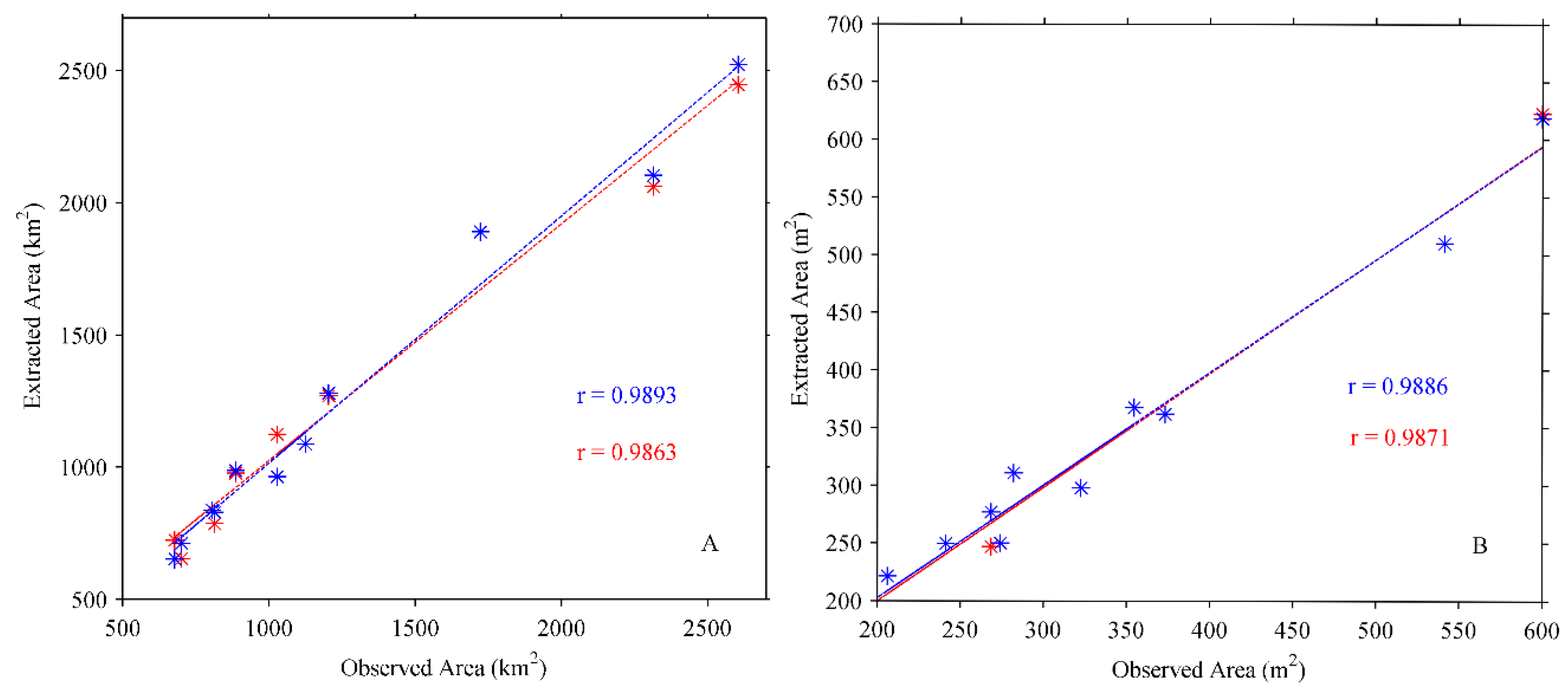
We calculated the RE, RMSE and r values between the extracted area and observed area. The extraction accuracies (1-RE) of the conventional methods for the water surface and algal bloom areas were 93.12% and 94.11%, respectively, and the corresponding RMSE values were 4.32% and 0.76%, respectively. The extraction accuracies of the traditional methods optimized by the DL-NN for extracting the areas of surface water and algal blooms were greater than 94.53% and 94.66%, respectively, and the corresponding RMSE values were 3.60% and 0.71%, respectively. In addition, the r values between the water surface and algal bloom areas with the optimized methods were superior to those with the traditional methods, as determined by the fit between the extracted area and observed area (Figure 3). The optimized methods can improve the extraction accuracy of surface water and algal blooms. Most importantly, the DL-NN overcomes the shortcomings of traditional methods that need to take a global threshold value for each image. Therefore, in this paper, the extraction results from the optimized methods were used to analyze the changes in the water surface and algal bloom areas in Dongting Lake from 2001 to 2017.
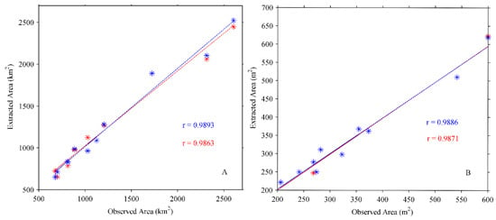
Figure 3.
Comparison between the extracted and observed areas ((A)—water area, (B)—algal bloom area). (Blue-extraction results from the traditional methods optimized by the DL-NN; red-extraction results from the traditional methods; the extracted area refers to the extraction results from the MODIS images; observed area refers to the corresponding the extraction results from the Landsat images).
3.1.2. Comparison with Water Level Data
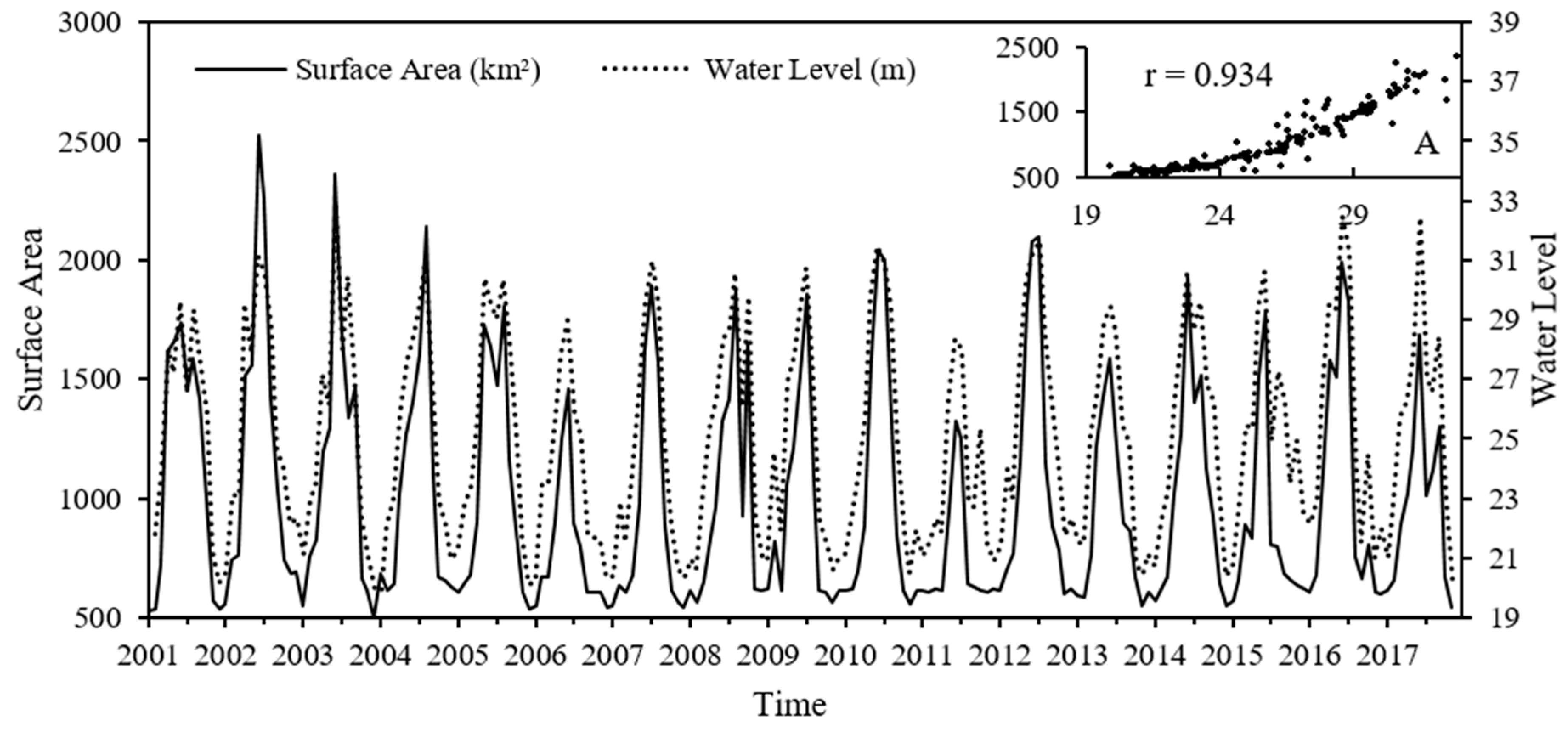
Water level time series from in situ stations were used to further verify the water extraction accuracy of the traditional methods optimized by the DL-NN in Dongting Lake because the surface area and water level are highly correlated. The dates of the water level data correspond to the dates of the MODIS images. The comparisons indicated very good agreement between the water levels and surface areas (Figure 4). We also computed the r values between the water surface area and water level in Figure 4, which displays the resulting scatter plot of the correlations (). These correlations further indicate that the results of the optimized methods for the extraction of surface water are accurate.
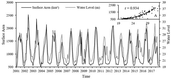
Figure 4.
Relationship between the lake water area and water level. A is a scatter plot of the correlations.
3.2. Characteristics of the Variations in the Water Area of Dongting Lake
3.2.1. Analysis of the Interannual and Seasonal Changes in the Water Surface Area
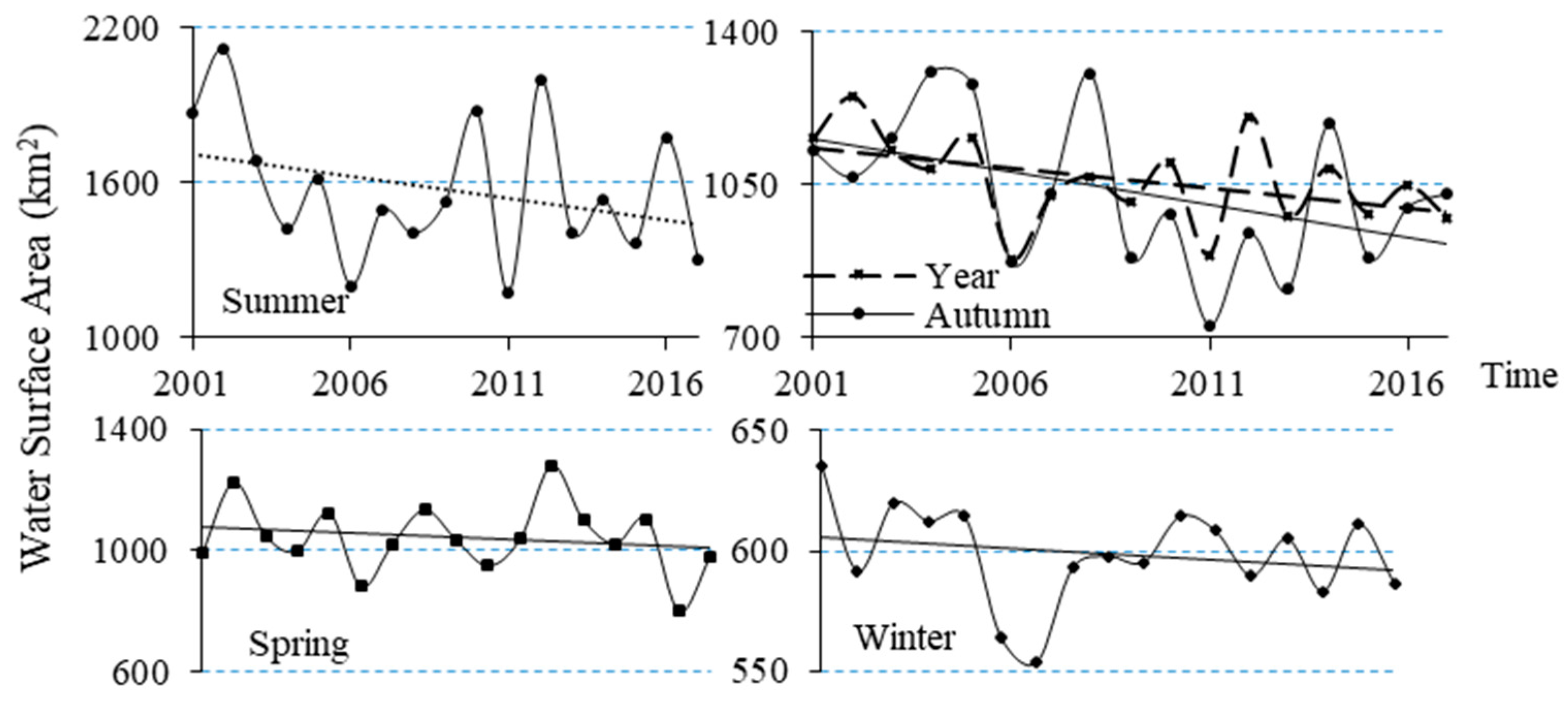
The seasonal and interannual changes in the water area of Dongting Lake from 2001 to 2017 are shown in Figure 5. The water area of the lake displayed a declining trend between 2001 and 2017, with a minimum in 2011 at an area of 888.17 km2; the maximum was reached in 2002 with an area of 1249.43 km2. The water surface area of Dongting Lake changed seasonally; the lake area was small in spring and winter and larger in spring (approximately 1000 km2) than in winter (550–650 km2). The lake area was large in both summer and autumn but peaked in summer; the largest area of 2114.32 km2 occurred in the summer of 2002. In addition, the surface area of Dongting Lake in spring, summer, autumn, and winter showed a decreasing trend from 2001–2017; the largest rate of decrease was in summer, and the summer variation rate reached −16.49 km2/a, followed by a rate of −14.93 km2/a in autumn. The rates of decrease were small in spring and winter at −4.05 km2/a and −0.88 km2/a, respectively. These characteristics are related to precipitation, temperature conditions, the operation of the Three Gorges Reservoir (TGR), and the main flood season of the Yangtze River in the Dongting Lake region [73,91].
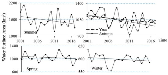
Figure 5.
Seasonal and interannual changes in the water area of Dongting Lake from 2001–2017.
3.2.2. Analysis of the Monthly Spatial Changes
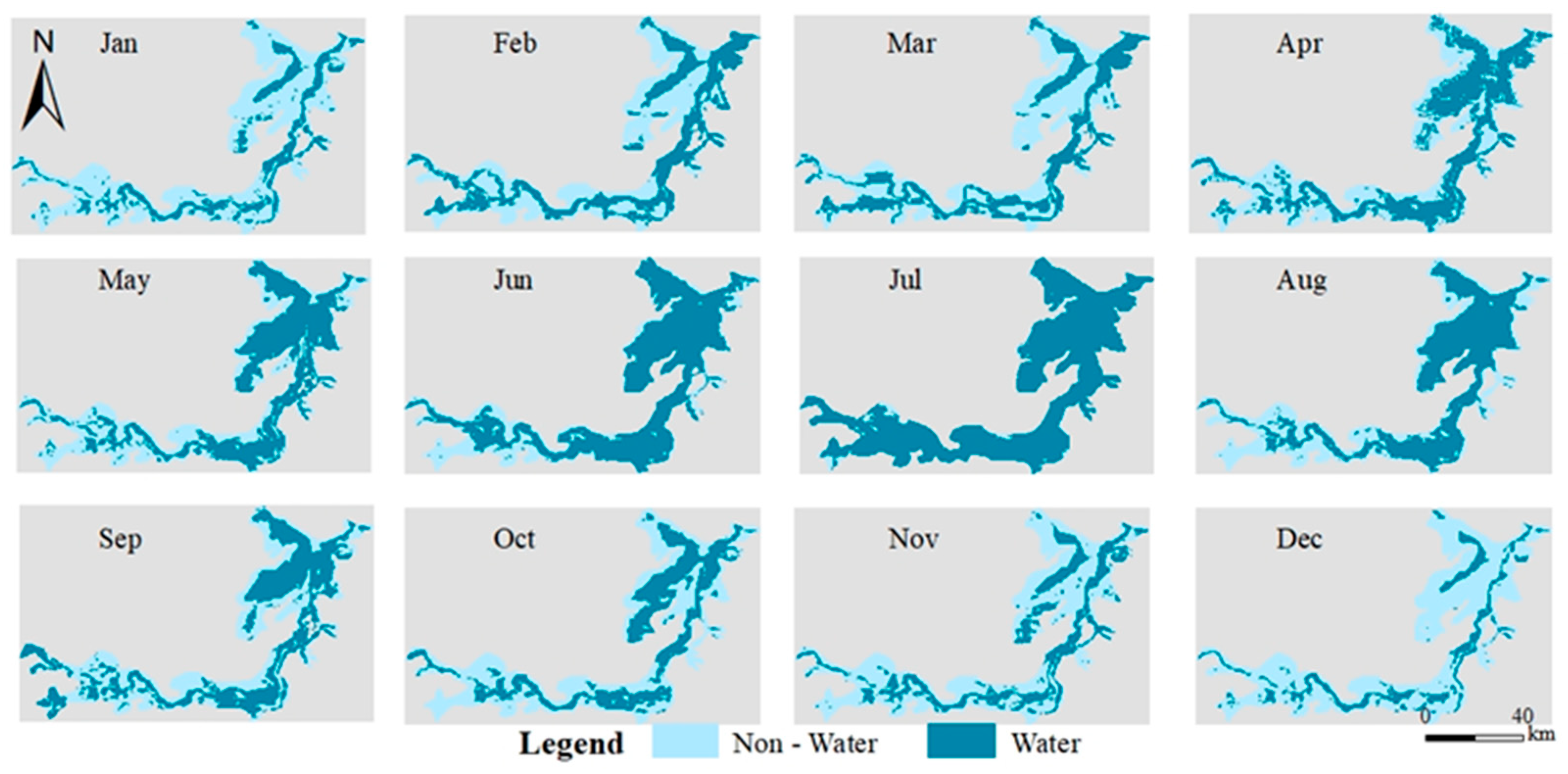
The spatial characteristics of the water surface distribution in Dongting Lake significantly differed over a 1-year period, and the variation characteristics of the water surface exhibited obvious regional differences (Figure 6). The water surface area of eastern Dongting Lake was large in summer and autumn, while only a few ribbons of water remained in winter and spring, when the variation in the water surface area was the largest. The variations in the water surface area in southern Dongting Lake and western Dongting Lake were smaller than those in eastern Dongting Lake. Similarly, the water surface areas were large in summer and autumn and small in winter and spring. Evidently, the water surface area was dynamically changing. In the dry season (December–February), Dongting Lake lost nearly 53.94% of its surface, the water area was small, and only a few ribbons of water remained (with an area of 598.48 km2). In the rainy season (May–October), the water area was large with an average of 1299.23 km2. In addition, the variations in the water area of Dongting Lake in the dry season were opposite to those in the rainy season, and the spatial distributions of the changes in the water area were similar in each lake section. The largest dynamic spatiotemporal changes in the water surface area occurred in eastern Dongting Lake, and the seasonal hydrofluctuation belts were distributed mainly in the southern and western regions of eastern Dongting Lake with an average area of 358.53 km2. The second largest seasonal hydrofluctuation belt was in southern Dongting Lake with an average area of 239.86 km2, and a seasonal hydrofluctuation belt was distributed primarily in the southern portion of southern Dongting Lake. The area of the seasonal hydrofluctuation belt was the smallest in western Dongting Lake, with an average area of 130.83 km2, where the belt was distributed mainly in the area near the lakeshore.
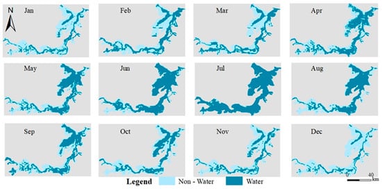
Figure 6.
Changes in the spatial distribution of the water area in different months.
3.2.3. Analysis of the Interannual Spatial Changes
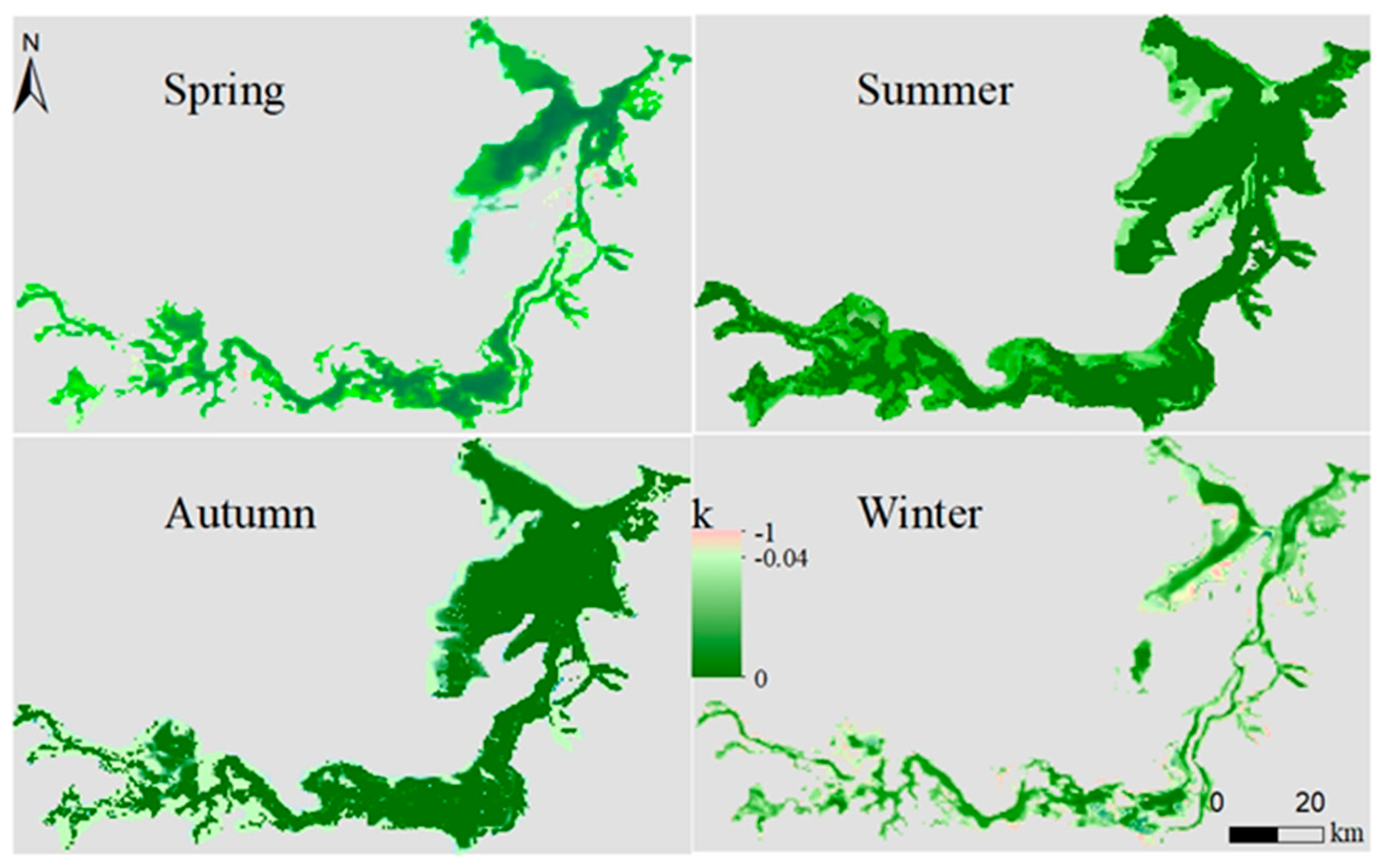
For a more detailed understanding of the spatial patterns and regional differences in the water surface changes in different areas, the per pixel frequency of water detection in each season from 2001 to 2017 was calculated, and the slope (k) (Figure 7) is shown. The frequency of water detection was calculated as the number of times water was identified in each pixel from a stack of all water/non-water classifications for each season of the year. From 2001 to 2017, strong interannual variation in spatial water frequency patterns across the Dongting Lake was detected from our pixel-level analysis (Figure 7), revealing striking differences between years. The frequency of water detection decreased significantly in all four seasons in the East Dongting Lake. The frequency of South Dongting Lake decreased in the three seasons including spring, summer and autumn. The frequency decrease of the West Dongting Lake was mainly observed in summer and autumn. The frequency reduction of these three lake areas occurred dominantly in the lakeshore area.
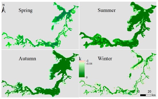
Figure 7.
Spatial dynamics of interannual change trends in water surface area from the slope during 2001–2017 (k describes the rate of the frequency increasing/decreasing; a negative k indicates a decrease in the frequency (decreasing)).
3.3. Characteristics of the Variations in the Algal Bloom Area in Dongting Lake
3.3.1. Seasonal Variations in the Algal Bloom Area
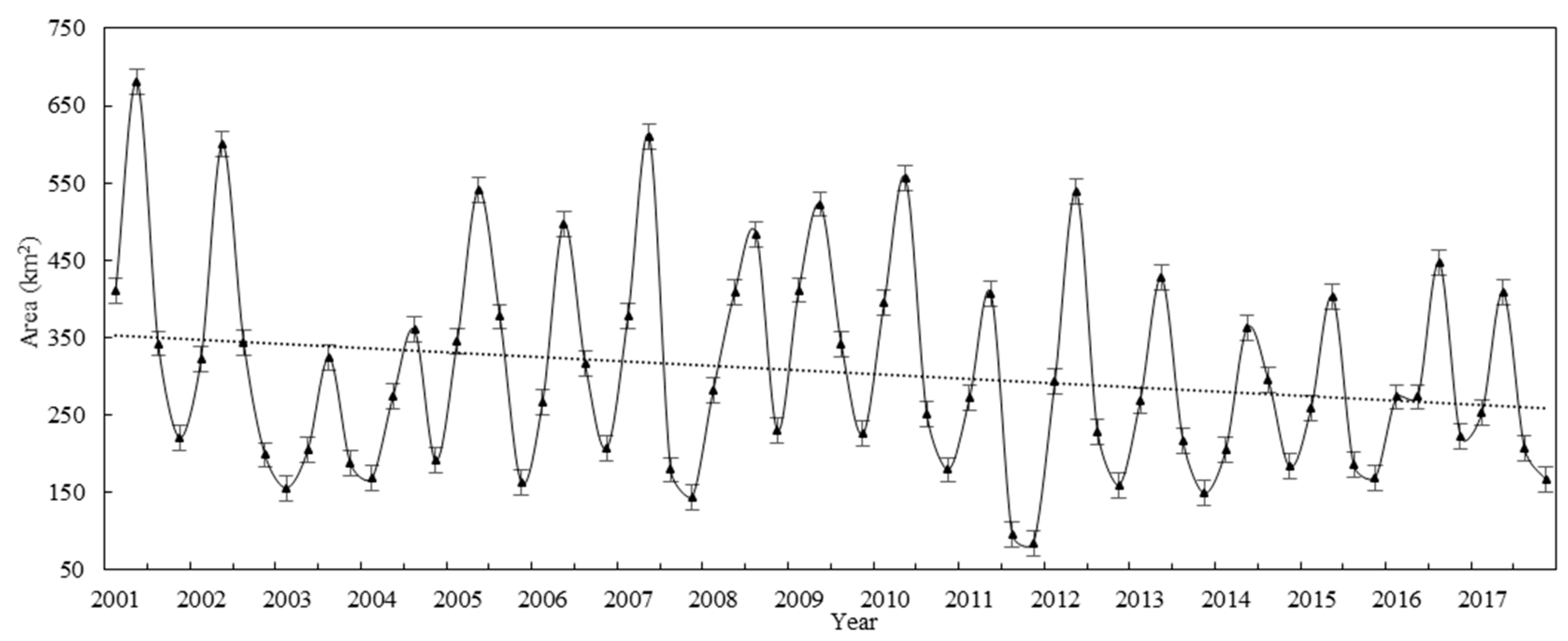
The statistics of the algal bloom outbreak areas in Dongting Lake during different seasons from 2001 to 2017 (Figure 8) indicate that the algal bloom area in Dongting Lake exhibits a normal distribution within a 1-year period and that most algal blooms occur in the summer and fall seasons. This abundance of algal blooms is associated primarily with the high water temperatures in summer and autumn that provide suitable conditions for algal growth. The area of algal blooms in Dongting Lake was the largest in summer, followed by autumn, and the smallest areas were observed in spring and winter. Between 2001 and 2017, the annual average area of algal blooms reached approximately 233.02 km2 in 2003 and 2004 when the algal bloom area was small and reached a maximum of 413.47 km2 in 2001. In general, the area of algal blooms in Dongting Lake showed a declining trend over the study period spanning nearly 17 years.
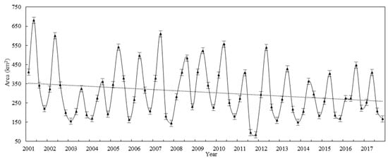
Figure 8.
Average bloom areas in Dongting Lake in different seasons from 2001–2017.
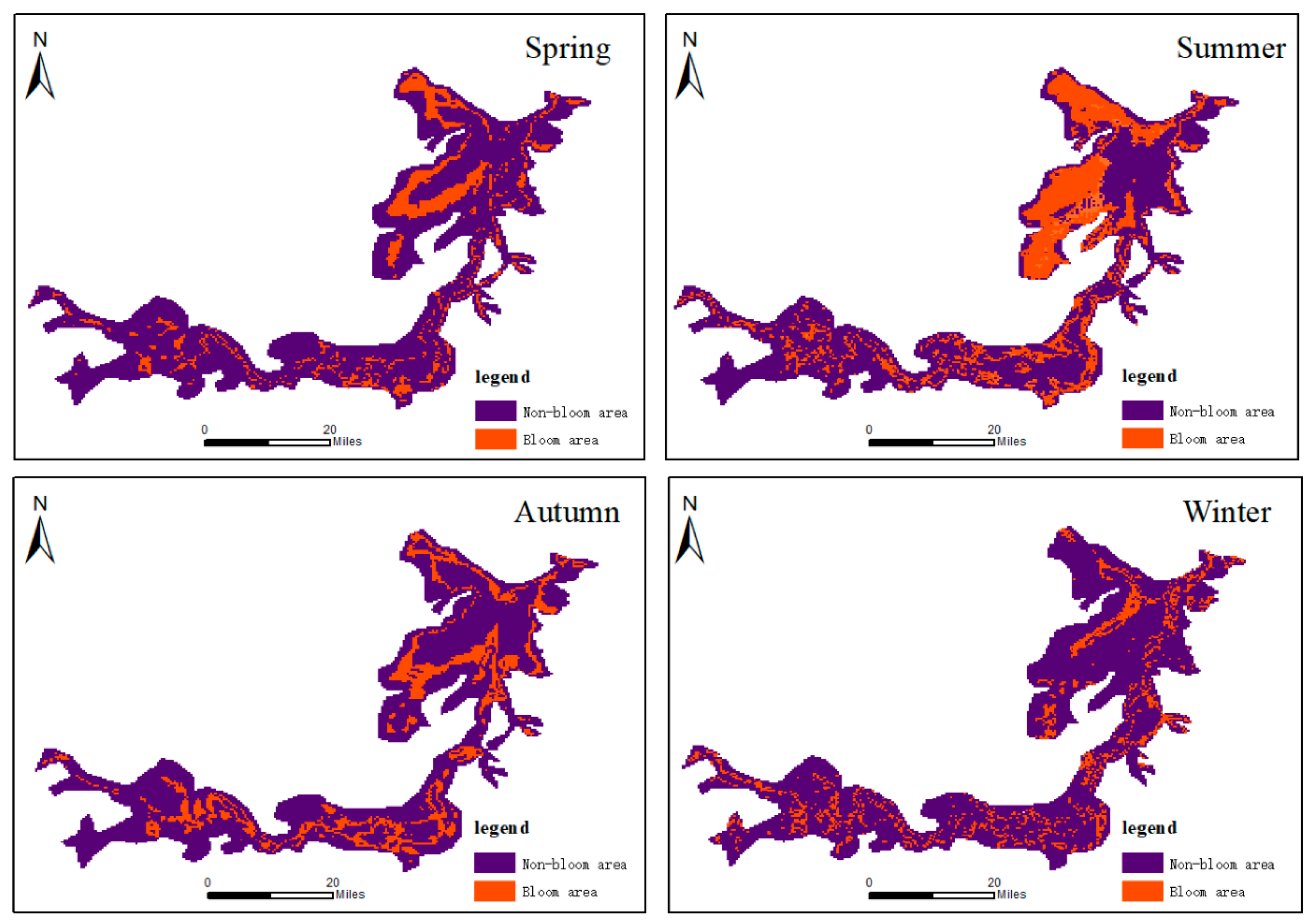
The regions of algal bloom occurrence in Dongting Lake during different seasons from 2001 to 2017 were statistically analyzed, and distribution maps of the algal blooms in different seasons were obtained (Figure 9). Eastern Dongting Lake experienced more frequent algal blooms than the other two regions of the lake, and the area of algal bloom occurrence was concentrated mainly in the easternmost part of the lake. The largest area occurred in summer, followed by autumn and spring, and the smallest algal bloom area occurred in winter. The largest algal bloom areas occurred near the lakeshore in western and southern Dongting Lake, while the center of the lake exhibited the smallest algal bloom area. Furthermore, western and southern Dongting Lake experienced more frequent algal blooms in autumn than during the other three seasons. For the whole lake, the algal blooms expanded to the center of Dongting Lake after spring and then decreased after summer.
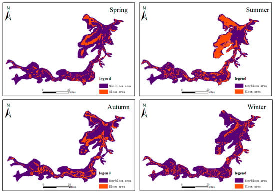
Figure 9.
Changes in algal blooms in Dongting Lake in spring, summer, autumn, and winter from 2001–2017.
3.3.2. Interannual Variations in the Algal Bloom Area
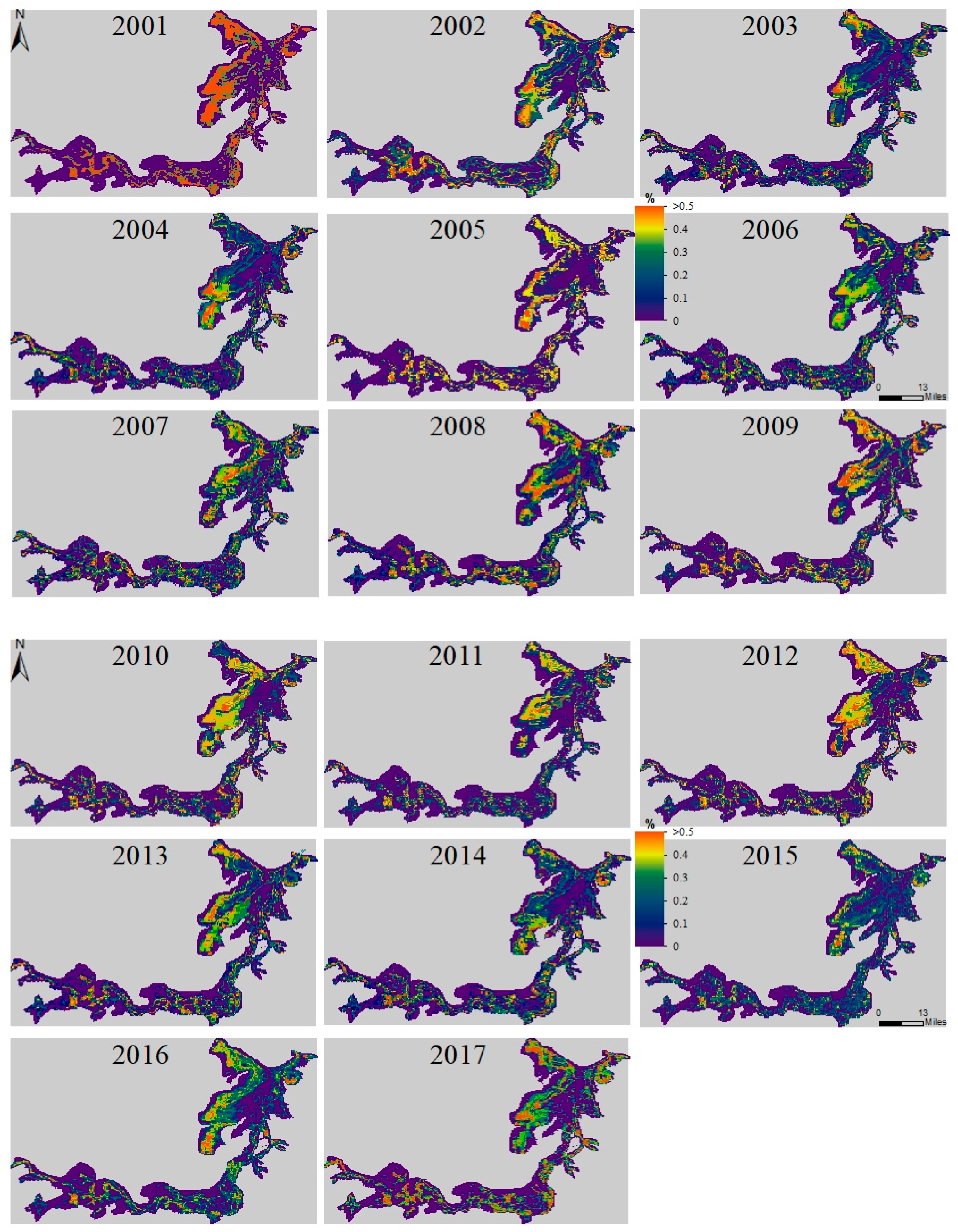
The frequencies of algal blooms in different areas of Dongting Lake from 2001 to 2017 were similarly analyzed (Figure 10). Algal blooms occurred in all 17 years and were distributed primarily near the lakeshore. Blooms occurred very frequently in 2001 with an occurrence rate exceeding 50% near the western shore of eastern Dongting Lake, and eastern Dongting Lake showed the largest area with significant bloom coverage. The frequency of algal blooms was low in 2003 and 2004, mainly at 20–30%, except in the northwestern and southwestern parts of eastern Dongting Lake.
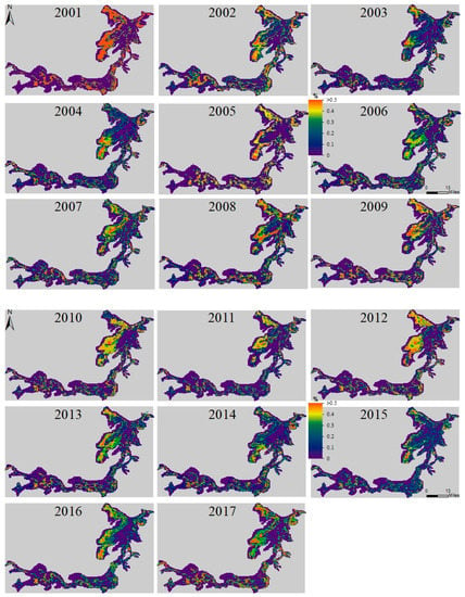
Figure 10.
Frequencies of blooms in different areas of Dongting Lake from 2001 to 2017.
The western and northeastern sections of eastern Dongting Lake experienced more frequent algal blooms than the other two sections of the lake, where the algal blooms tended to expand from the shore to the center of the lake. The frequency of algal bloom occurrence decreased gradually from the shore to the interior of the lake area. There are 17 major pollution sources around eastern Dongting Lake, with a daily discharge volume of 126,359 m3, accounting for 85.55% of the total daily discharge; accordingly, large quantities of pollutants have been discharged into the lake from agriculture, industries, and aquaculture, resulting in nutrient concentrations that are significantly higher in the eastern part of Dongting Lake than in the western and southern parts of the lake [92,93]. The northeastern region of eastern Dongting Lake is simultaneously located near both the city of Yueyang, which shows considerable growth potential with a large population and widespread industrial activities, and the confluence of eastern Dongting Lake and the Yangtze River, where numerous pollutants accumulate and are released from the lake sediments due to disturbances from the Yangtze River. Therefore, significant algal blooms appeared in the northeastern part of eastern Dongting Lake. In contrast, the western region of eastern Dongting Lake is restricted by its geographical location and is not impacted by the estuary, and the amount of water in this area is low. In addition, the terrain of Dongting Lake is high in the northwest and low in the southeast. The water flows from west to east through Chenglingji into the Yangtze River, and thus, water exchange does not occur frequently in the western part of the lake. Moreover, the water variability is small, and pollutants accumulate more easily in this area than in other areas, resulting in water quality deterioration. This nutrient pattern is the primary reason for the obvious west-to-east decrease in the algal bloom occurrence frequency.
In western and southern Dongting Lake, algal blooms were distributed sporadically along the shore, and the area of algal bloom occurrence in western Dongting Lake was smaller than that in southern Dongting Lake. Although 19 sources of industrial pollution are situated around southern Dongting Lake, the daily pollutant discharge of these sources is 179,237 m3, accounting for only 12.14% of the total daily discharge of Dongting Lake. Furthermore, the economy around southern Dongting Lake is poorly developed, and the nonpoint-source pollution therein is lower than that in eastern Dongting Lake. Therefore, algal blooms in southern Dongting Lake encompass a smaller area than those in eastern Dongting Lake. In contrast, the environment around western Dongting Lake is better than that around the other two areas of the lake. There are only six industrial pollution sources, with a daily discharge of 34,191 m3, accounting for only 2.31% of the total daily discharge of Dongting Lake. At the same time, the surrounding population is small, and economic development has been slow, so the algal bloom area was smallest in western Dongting Lake.
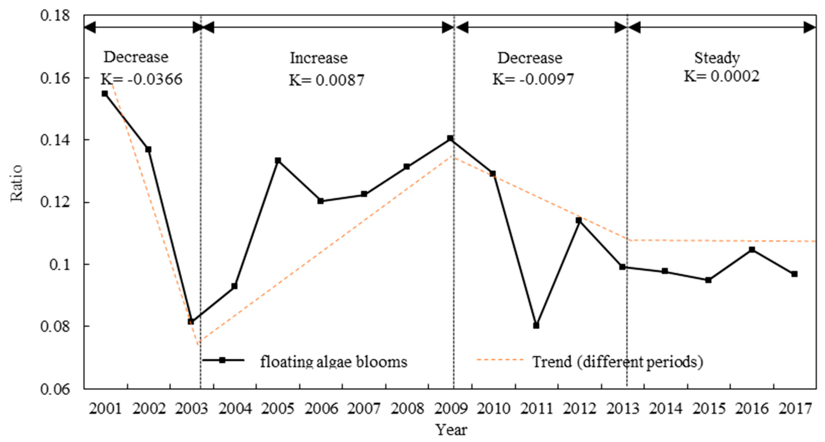
Algal blooms in Dongting Lake occur mainly between April and September. To more clearly ascertain the interannual changes in algal blooms, we analyzed the average area of algal blooms in Dongting Lake during April to September from 2001 to 2017. The monthly maxima is more representative of the monthly water bloom coverage than the monthly average value due to the influence of wind on the formation of the surface mats [64,65]. Therefore, on the basis of this argument, the annual bloom coverage for the lake were estimated from the mean of monthly maxima, in which these months were from April to September. Then we also calculated the average of the water area extracted from April to September, and finally a time-series of bloom changes was determined using the annual bloom coverage compared with the average of the water area extracted. The results are presented in Figure 11. The changes in the algal bloom area showed decreasing, increasing, decreasing and stabilizing trends over time; accordingly, the changes in the algal bloom area of Dongting Lake were divided into four periods. First, the algal bloom area of Dongting Lake gradually decreased from 15.46% in 2001 to 8.15% in 2003 with an average annual reduction of approximately 3.66%. The second phase was a period of expansion that occurred from 2003 to 2009, during which the ratio of the algal bloom area to the area of Dongting Lake increased by approximately 0.87% per year. The third phase (2009–2013) was another decreasing period. After 2009, the algal bloom outbreak area in Dongting Lake gradually decreased, with the algal bloom area reaching 9.91% in 2013. Finally, the fourth phase (2013–2017) was a stable period, during which no significant increase or decrease in the algal bloom area showed in Dongting Lake.
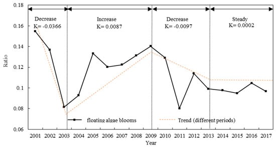
Figure 11.
Percentage of the algal bloom area relative to the entire lake area from 2001–2017. (K is the annual change in Y, and Y is the ratio of the bloom area to the area of Dongting Lake).
3.3.3. Intensity Analysis of Algal Blooms in the Summer and Autumn Seasons
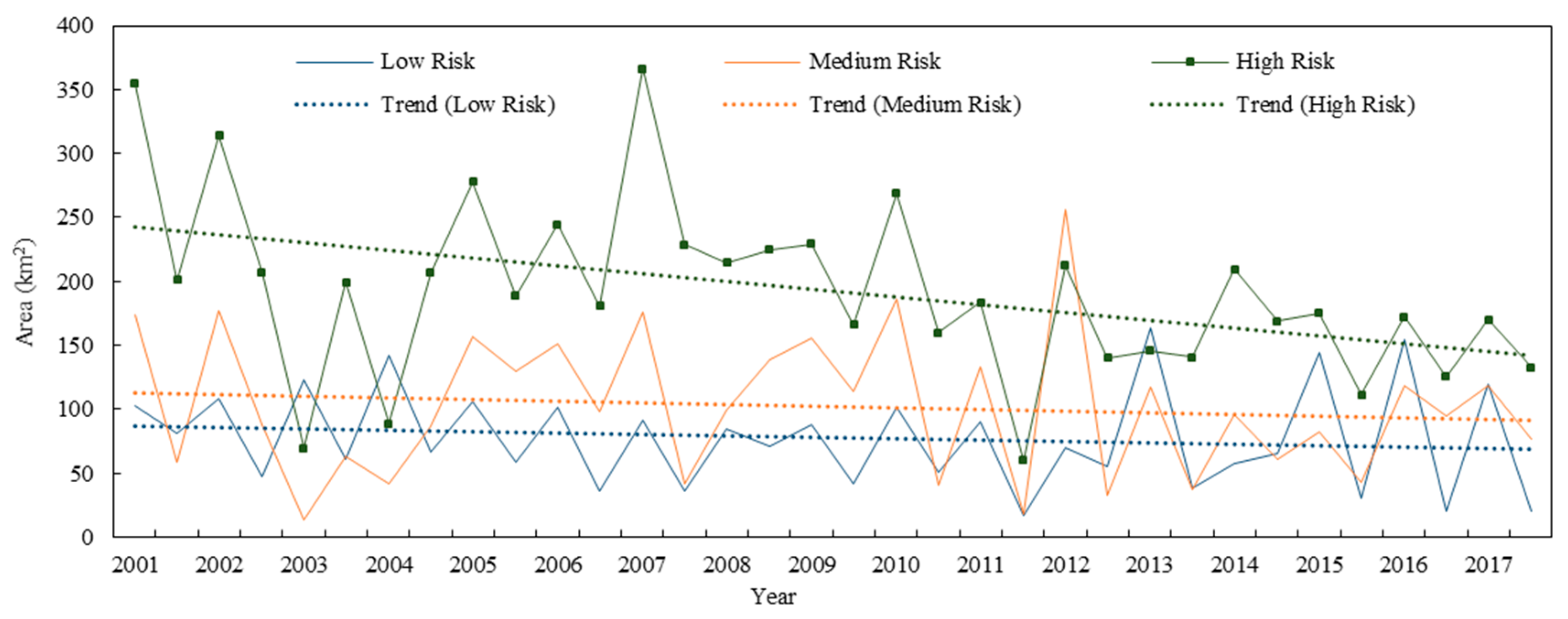
To further evaluate the intensity of algal blooms, the equal-interval grading method was used to divide the algal blooms into three levels according to the degree of algal bloom severity: low risk (−0.004 ≤ FAI ≤ 0), medium risk (0 ≤ FAI ≤ 0.004) and high risk (0.004 ≤ FAI ≤ 0.2).
Because algal blooms occur frequently in many lakes throughout China during summer and autumn [94], three different risk levels of algal blooms were analyzed during these two seasons from 2001 to 2017 (Figure 12). Of all the summers during the study period, 2007 was the worst year in terms of the algal bloom abundance. The summer high-risk area in Dongting Lake was the largest in 2007, reaching 366.74 km2, after which the area of algal blooms declined. In the autumns between 2001 and 2017, the most serious outbreak of algal blooms in Dongting Lake occurred in 2007. Hence, the autumn high-risk area in Dongting Lake was the largest in 2007, reaching 228.99 km2, after which the area of algal blooms in Dongting Lake obviously decreased. A comparison between the algal bloom areas in the summer and autumn seasons of the same year reveals that the bloom area at the same risk level was larger in summer than in autumn for most years; the area in summer was smaller than that in autumn only in 2008. Generally, algal blooms exhibit a larger range of outbreaks in summer than in autumn, but this range is affected by precipitation and other factors, which can result in an increase in the area of algal blooms in autumn.
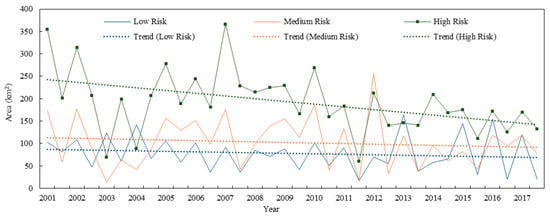
Figure 12.
Variation trends of the areas of different algal bloom risk levels during summer and autumn from 2001–2017.
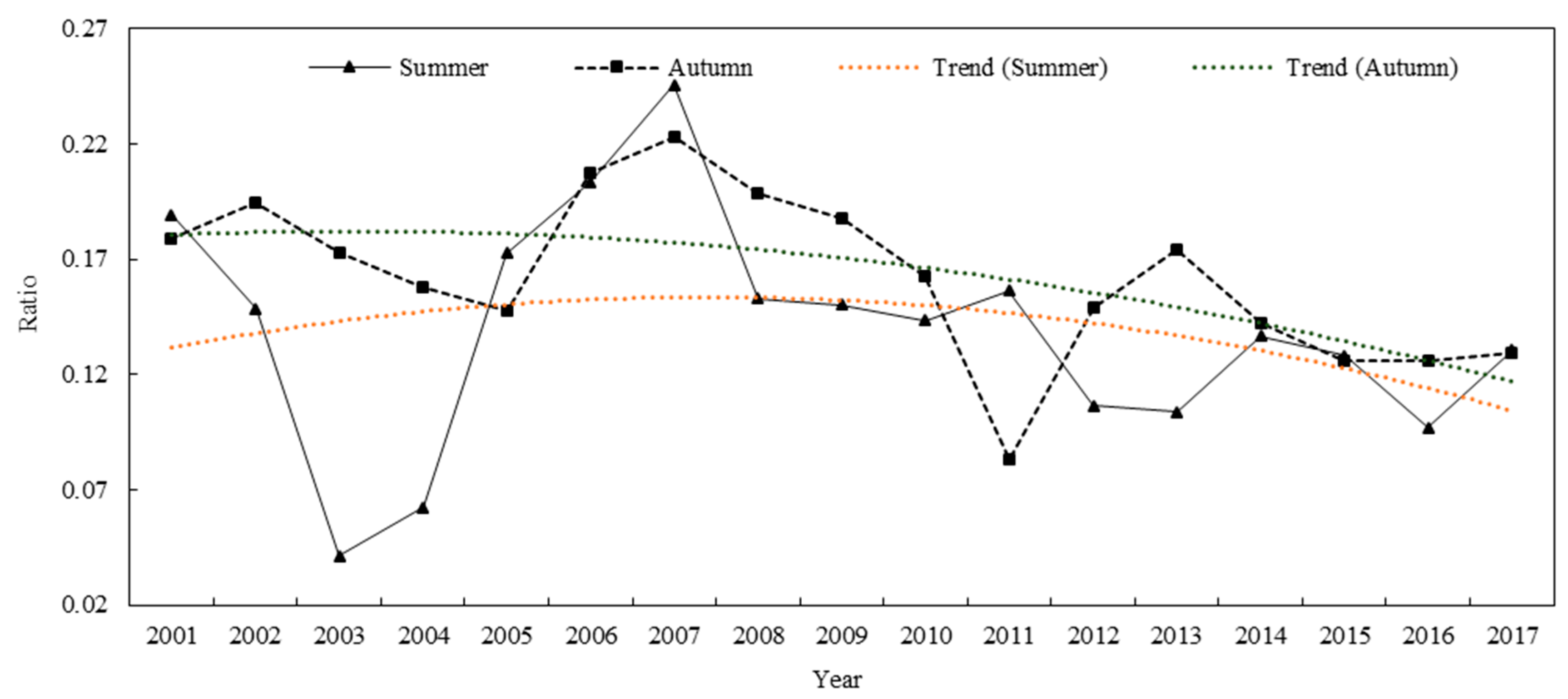
The area of a cyanobacteria algal bloom outbreak is not a good indicator of the severity of an outbreak because the outbreak severity is also related to the total lake area. Therefore, it is more reasonable to use the ratio of the algal bloom outbreak area to the total water body area at the corresponding time. Once again, we analyzed the high-risk area of algal blooms in Dongting Lake in summer and autumn between 2001 and 2017 (Figure 13). The pollution level was higher in the summer of 2007 than during the summers of other years, with the high-risk area accounting for 24.56% of the total water area. The pollution level was low in 2003 and 2004, and the algal bloom area was less than 90 km2, with the high-risk area accounting for 4.12% and 6.23% of the water area, respectively. The pollution level was higher in autumn 2007 than during the autumns of other years, with the high-risk area accounting for 22.29% of the total water area, while the pollution level was low in 2011, with the high-risk area accounting for 8.29% of the water area. On 1 April 2007, the government shutdown 234 polluting enterprises around Dongting Lake, resulting in a marked decrease in pollutants being discharged into the lake. Consequently, the ratio of the high-risk area to the total lake area in summer decreased from 24.56% in 2007 to 13.06% in 2017; the same ratio in autumn decreased from 22.29% in 2007 to 12.91% in 2017. Remarkably, the rate of decline in the high-risk area in summer was higher than that in autumn from 2007 to 2008. This result is related to the floods that occurred in Dongting Lake in late April 2008, resulting in a much larger water area in summer than in autumn.
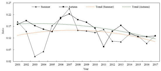
Figure 13.
Trends in the ratio of the algal bloom outbreak area to the total water area in two seasons from 2001–2017 (the bloom area represents the high-risk area).
4. Discussion
4.1. Environmental Drivers of Interannual Water Body and Algal Bloom Dynamics
In this section, the water area represents the average annual area of Dongting Lake, and the temperature and rainfall are the average values of the annual temperature and annual precipitation from the eight meteorological stations located around Dongting Lake.
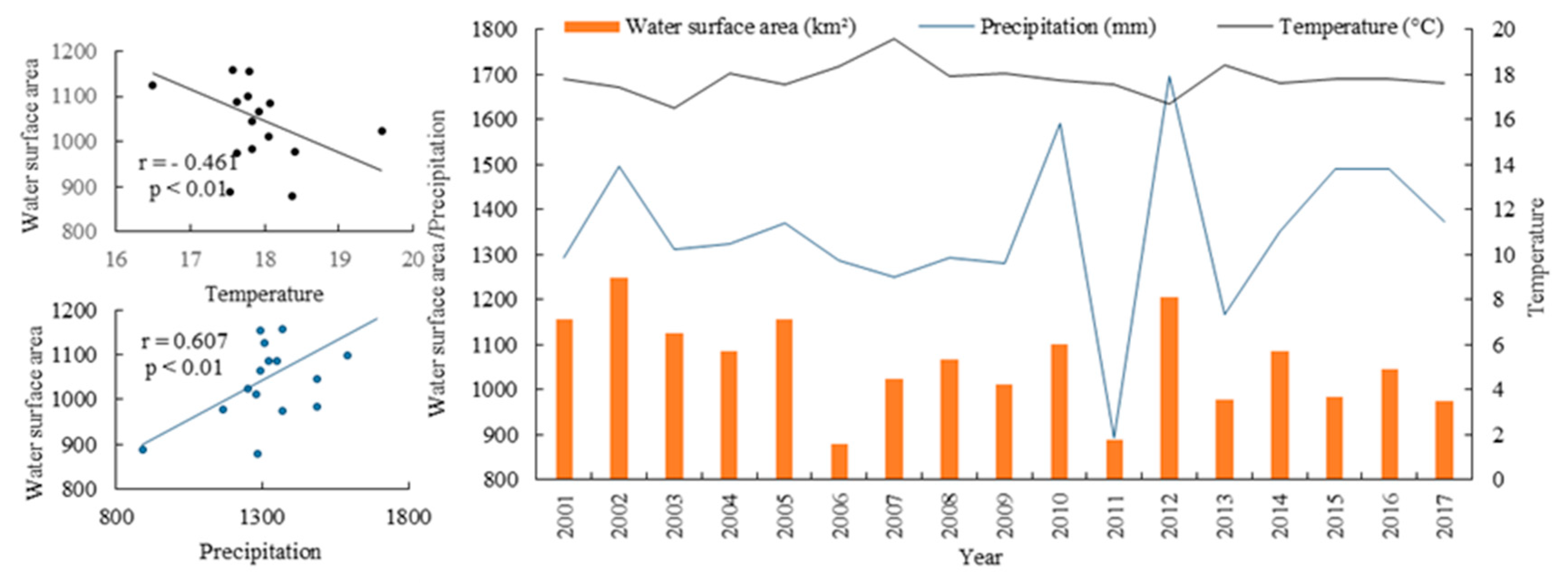
To determine the possible linkage of the interannual water body dynamics with local weather, several meteorological parameters of the past 17 years were plotted (Figure 14). In 2002, 2005, 2008, and 2012, when the water area reached a maximum, rainfall simultaneously reached a maximum, and the temperature was at a minimum. In 2004, 2007, 2011, 2013, and 2017, the water areas and rainfall levels were at a minimum, and the temperature was at the maximum in the study period. In addition, we separately calculated the Pearson correlation coefficients between the water area and the temperature and precipitation during this period. There is positive correlation between precipitation and the water area, and it is negatively correlated with temperature. However, from 2001 to 2017, the water area of Dongting Lake decreased gradually, while the temperature and precipitation showed a very slight upward trend. Thus, in some extreme years, such as drought or rain, the water area of Dongting Lake is closely related to the local weather [95]. However, as a whole, the shrinkage of the lake area during the study period could not be explained by either temperature or precipitation. The impact of human activities can be inferred to be the most important cause for the reduction in the water area of DongtingLake [91].
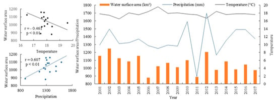
Figure 14.
Relationships between the Dongting Lake water area and annual average temperature and annual average rainfall from 2001–2017.
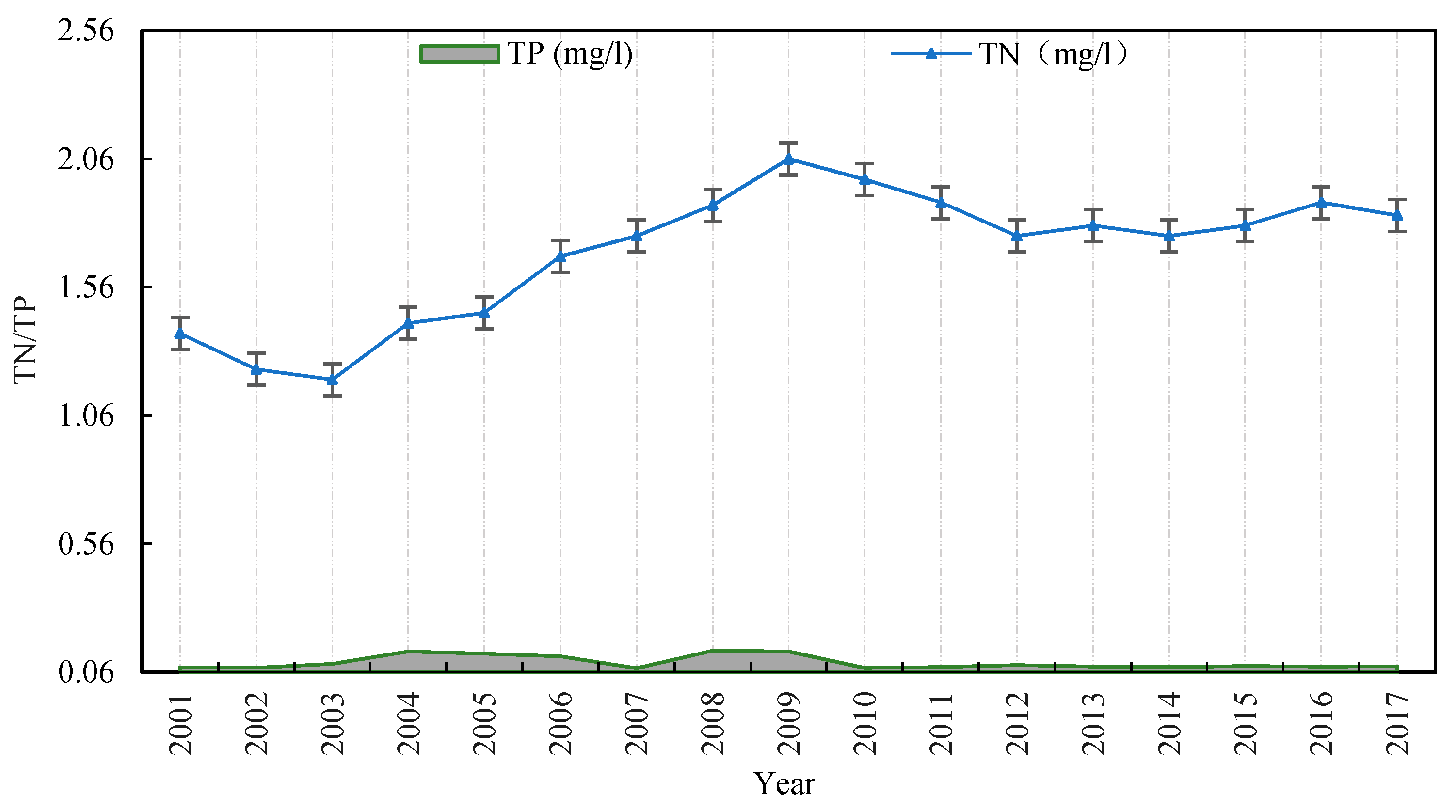
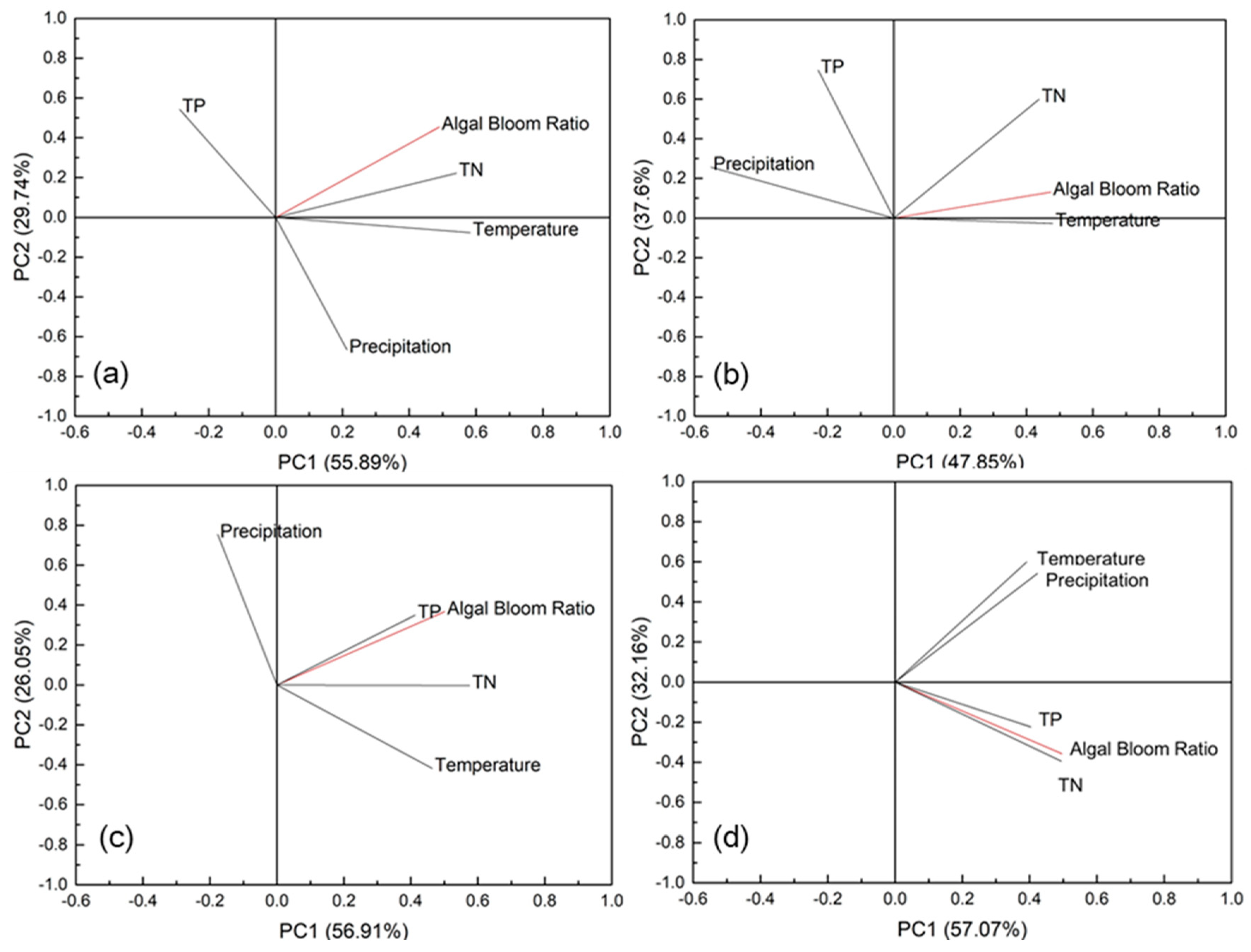
To determine the possible linkage of the interannual algal bloom dynamics with local weather and water quality data (TN, TP), several water quality parameters from in situ field of the past 17 years were plotted (Figure 15) and principal component analysis (PCA) was used to investigate the combined effects of water quality and local weather on the growth of algal blooms more quantitatively in 2001–2003, 2003–2009, 2009–2013, and 2013–2017 (Figure 16). In PCA ordination diagram, the correlation is shown as the cosine of the angle between any two axes in the figure, while the influence intensity is the distance one axis projected on another, and the distance can quantify how strong the correlation between the two is (the longer length, the stronger the correlation) [96]. Figure 16a shows that the algal blooms in 2001–2003 were mainly affected by the positive influence of TN and temperature. During this period, the annual bloom area of Dongting Lake decreased by 3.66%. This reduction may be due to the many floods that affected the Dongting Lake region between 1996 and 1999, during which surface runoff carried a large amount of nutrients into Dongting Lake, resulting in eutrophication [92]. Consequently, the 2001 algal bloom outbreak in Dongting Lake was quite serious. Subsequently, as the temperature dropped (Figure 14) and the nutrients (TN) in the water decreased (Figure 15) in 2001–2003, the water bloom area of Dongting Lake also decreased. In 2003–2009 (Figure 16b), algal blooms were mainly affected by the positive influence of TN and temperature, and the negative influence of precipitation, while TP had a small influence. During this period, secondary industries in the Dongting Lake surrounding cities, especially the machinery, chemical, and metal processing industries, developed somewhat rapidly, leading to the introduction of additional pollutants, and an increase in the direct discharge of domestic sewage [97]. In addition, the annual growth rate of grain crops, fertilizers and pesticides in Dongting Lake area is 1:4.7:14.6 in 2003–2009, resulting in serious agricultural nonpoint-source pollution [93]. As a result, the water quality of Dongting Lake worsened, and many coastal areas suffered from agricultural nonpoint-source pollution and industrial pollution, leading to algal blooms. The changes of algal blooms from 2009 to 2013 (Figure 16c) were mainly affected by the positive influence of TN and TP. After 2009, the algal bloom outbreak area in Dongting Lake gradually decreased, with the algal bloom area reached 9.91% in 2013 as a result of the numerous measures implemented by the Hunan Provincial Government beginning in 2008. These measures shut down many polluting enterprises in the region and increased the protection and management policies concerning Dongting Lake. As a result, the water quality of Dongting Lake improved significantly [97] (Figure 15), and the algal bloom area gradually decreased. The influencing factors of algal blooms variation from 2013 to 2017 (Figure 16d) were consistent with those in the previous years and were also mainly affected by the positive influence of TN and TP. The phase was a relatively stable period, during which no significant increase or decrease in TN and TP showed in Dongting Lake, and there was no significant increase or decrease in the algal bloom area.
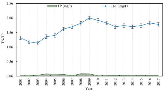
Figure 15.
Total nitrogen (TN) and total phosphorus (TP) in the lake during 2001–2017.
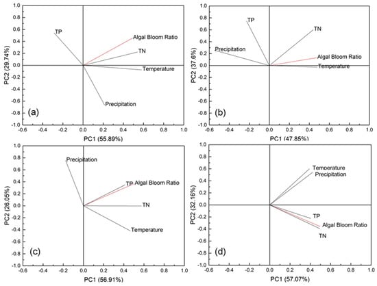
Figure 16.
PCA ordination diagram of interannual algal blooms in Dongting Lake. (a) 2001–2003; (b) 2003–2008; (c) 2008–2013; and (d) 2013–2017. (The bloom ratio is the ratio of the annual mean algal bloom area to the water surface area in the same year).
4.2. Environmental Drivers of Monthly Water Body and Algal Bloom Dynamics
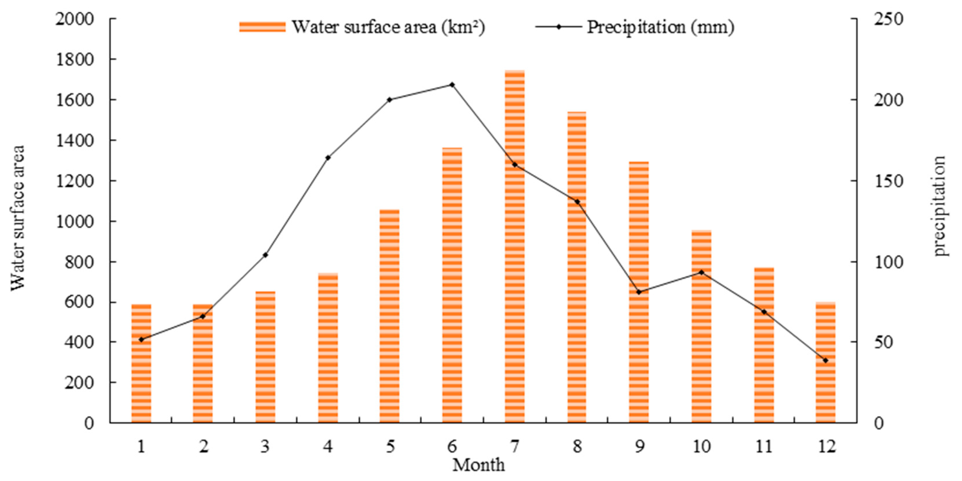
The average monthly water surface area of Dongting Lake from 2001 to 2017 coincided well with the rainfall pattern in different seasons. According to Figure 17, large water surface area occurred between July and September during the second half of the wet season; the average water surface area of Dongting Lake reached 1325.87 km2 during the wet period. In addition, small water surface area occurred between November and February during the dry season, with an average water area of 593.46 km2. Over the past 17 years, the average water area of Dongting Lake during the wet season was 2.2 times greater than that during the dry season. From 2001 to 2017, the Dongting Lake water surface area changed greatly in August, September, and November, with the surface area fluctuating by more than 320 km2. In addition, the Dongting Lake surface area changed less in January and March (fluctuating by only 142 km2) than in other months. Compared with the monthly precipitation climatology for the 17-year study period, it suggests that the significant seasonality in the water surface area might be primarily controlled by precipitation. We also calculated the Pearson correlation coefficients between the monthly water area and precipitation during this period, with a Pearson correlation coefficients of 0.62 (p-values < 0.01), which also indicated that the precipitation is an important cause for the monthly water body dynamics.
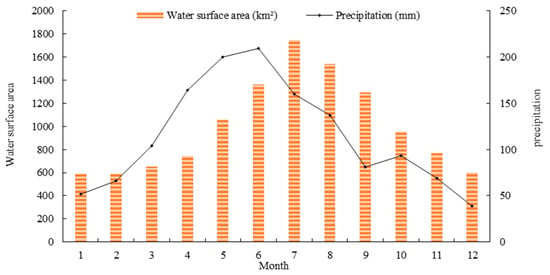
Figure 17.
Comparison between the monthly water area and monthly average rainfall in Dongting Lake from 2001–2017.
To determine the possible linkage of the monthly algal bloom dynamics with local weather and water quality data (TN, TP), principal component analysis (PCA) was used to investigate the combined effects of water quality and local weather on the growth of algal blooms more quantitatively. Figure 18b shows that the monthly algal bloom dynamics in 2001–2017 were mainly affected by the positive influence of temperature or precipitation, while TP and TN denote an insignificant relationship. Therefore, we further studied the relationship between meteorological factors and monthly bloom dynamics. The average precipitation, average temperature and average bloom area during each month from 2001–2017 were calculated. Figure 18a shows that the changes in the algal bloom area in Dongting Lake were consistent with the precipitation and temperature trends, showing a trend of first increasing and then decreasing, which further indicates that the extents of algal blooms in Dongting Lake throughout the year are affected by precipitation and the water temperature. Theoretically, sunlight is limited when precipitation is abundant, and algae in water exhibit strong phototaxis; thus, cloudy and rainy weather is not conducive to the formation of algal blooms or algal floating. Simultaneously, the water area increases with increased precipitation, and the lake water becomes diluted; correspondingly, the concentration of algal blooms is reduced [98,99]. A decrease in the algal bloom area was detected in the remote sensing images. However, the result of this study show that the monthly algal bloom dynamics in Dongting Lake is affected by the positive influence of precipitation. This positive influence may be because increased precipitation increases runoff into the lake, resulting in nonpoint-source pollutants flowing into Dongting Lake, thereby providing favorable conditions for algae growth [92,93].

Figure 18.
(a) Relationships between the average monthly precipitation, average monthly water temperature and algal bloom area from 2001–2017. (b) PCA ordination diagram of monthly algal blooms in Dongting Lake.
4.3. Potential Impact of the Three Gorges Dam on the Water Area Changes
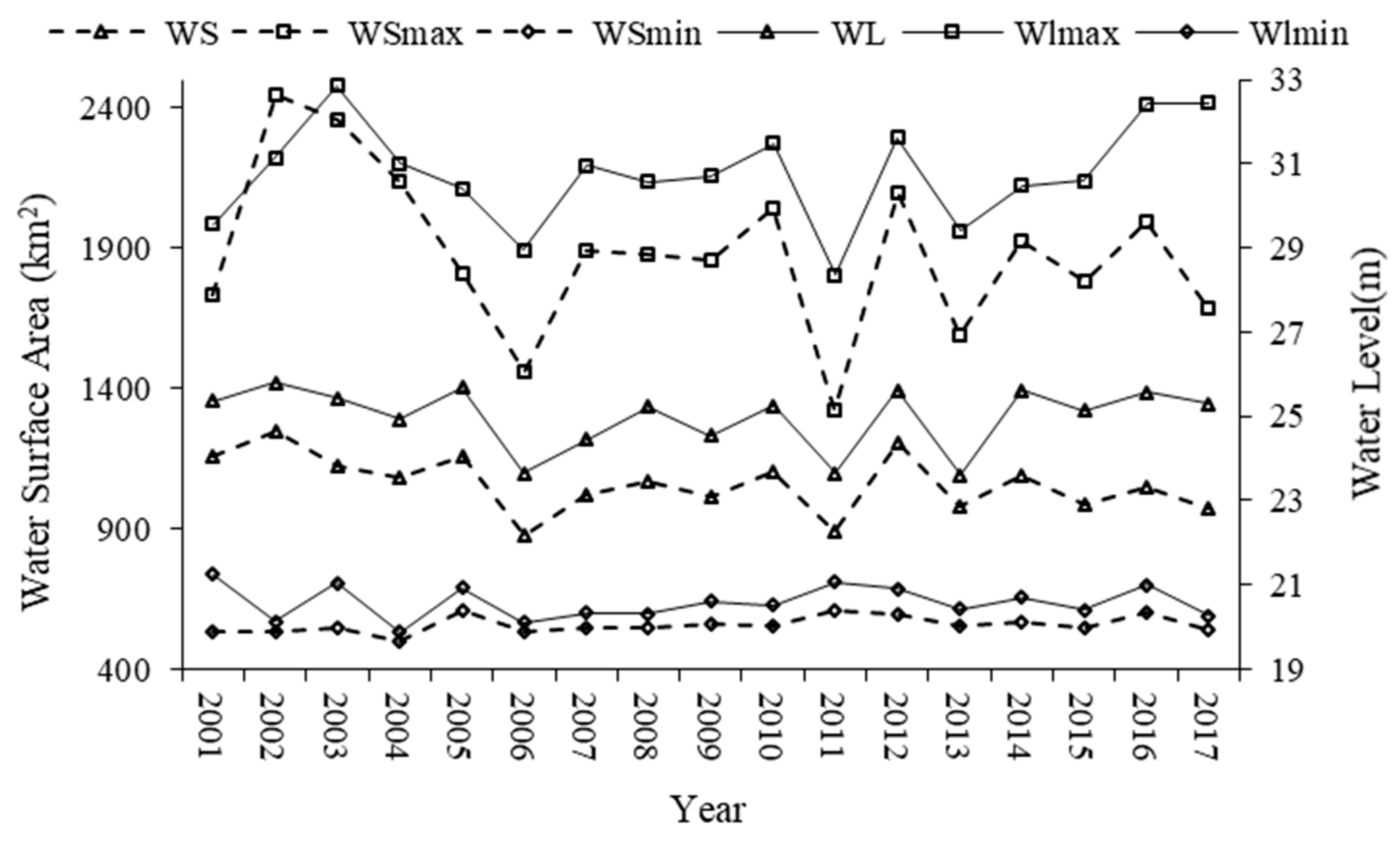
The changes in the water and sediment discharge regimes in the middle and lower reaches of the Yangtze River due to the operation of the Three Gorges Dam (TGD) have inevitably led to changes in the water level and surface area of Dongting Lake [100,101,102]. The volume of water trapped by the TGD often changes the flow regime and leads to an overall reduction in the water level in the downstream river reaches, thereby affecting the water surface areas and water levels of downstream lakes [91,103]. The water level at the Chenglingji hydrological station and the lake water area during the pre-TGD (2001–2003) and post-TGD (2004–2017) periods are shown in Figure 19. The variations in the annual minimum water surface area (WSmin) and annual minimum water level (WLmin) displayed no clear pattern. However, the annual maximum water surface area (WSmax) and annual maximum water level (WLmax) showed decreasing trends. Furthermore, the difference between WSmin and WSmax and the difference between WLmin and WLmax in the post-TGD period were lower than those in the pre-TGD period. The annual water surface area and annual water level in the post-TGD period were lower than those in the pre-TGD period. Specifically, the annual mean surface area of Dongting Lake decreased by 13.3% (from 1177 km2 in the pre-TGD period to 1034 km2 in the post-TGD period). Chenglingji recorded an annual mean water level of 25.41 m during the pre-TGD period, which decreased by 0.43 m to 24.98 m in the post-TGD period. The fluctuations in the annual average water level and annual average water surface area were small (0.5 m and 100 km2) before TGD operations began. After the completion of the TGD, these fluctuations increased significantly, with the annual average water level and water surface area reaching 2.0 m and 300 km2, respectively. In addition, after the impoundment of the TGD, the supplies of water from the Songzi, Hudu, and Ouchi channels and the Xiang, Zi, Yuan, and Li tributaries were significantly reduced. Since the operation of the TGD began, the annual mean runoff in the three channels has decreased from 625 × 10 8 m3 (1999–2002) to 478 × 108 m3 (2003–2017), a decrease of 23.5%, and the annual mean runoff in the four tributaries decreased from 1815 × 108 m3 (1999–2002) to 1620 × 108 m3 (2003–2017), a decrease of 10.74% (Table 4). After the impoundment of the TGD, the streamflow decreased sharply in the middle and lower reaches of the Yangtze River, contributing to the shrinkage of Dongting Lake [104].
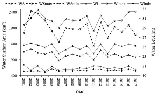
Figure 19.
Water surface area and water level trends from 2001–2017.

Table 4.
Variations in annual mean runoff in Dongting Lake (108 m3).
In addition to being impacted by the abovementioned reduction in the water supply, the area of Dongting Lake has been affected by sediment deposition within the lake. Although the TGD has acted as an interceptor of sediment, that is, the annual mean sediment inflow into Dongting Lake from the three channels and four tributaries decreased markedly due to the operation of the TGD, decreasing from 6835 × 104 t (1999–2002) to 1730 × 104 t (2003–2017), which has reduced the rate of sedimentation in Dongting Lake; however, siltation still occurrs and this sedimentation phenomenon in the lake area is not projected to stop [105,106]. Therefore, Dongting Lake will remain in a siltation state for at least a short period of time. The slow increase in the elevation of the lake bottom and the increase in siltation in shallow areas will gradually decrease the surface area of Dongting Lake.
4.4. Implications and Prospects
Based on the above analysis, the variations in the water area of Dongting Lake are driven not only by human factors but also by temperature, precipitation and the operation of the TGD. Monitoring the variations in the water area and the factors that influence Dongting Lake can provide guidance for the prevention and control of flood disasters in the lake. In particular, during seasons with abundant precipitation, monitoring the dynamic change of the surface water can provide early warning for the occurrence of flood disasters.
Nutrient concentrations are extremely important for the formation of algal blooms, although local meteorological conditions also influence the outbreak of algal blooms [107,108]. When the nutrient concentrations in the lake are relatively high, the algal bloom frequency will certainly increase as the climate warms. Especially in the period from March to May, when the temperature begins to rise, the algal bloom area will increase. During this period, water quality monitoring in regions with high algal bloom frequencies can provide early warning for the emergence of blooms. Nevertheless, the internal sources of contamination in the lake should be removed to improve the water quality and inhibit algal blooms when the water quality is poor.
Spatial and temporal monitoring and analyses of the water surface and algal bloom areas in Dongting Lake using remote sensing data can reflect the pollution emissions from surrounding enterprises and cities and can therefore provide real-time monitoring information for the government to control the water quality of Dongting Lake. However, due to the influences of factors such as clouds and aerosols and the limitations of existing algorithms, the extraction accuracy of the water area and algal bloom area must be improved. The use of the traditional algorithms optimized by the DL-NN to extract the target not only avoids setting a threshold for each image but also improves the extraction accuracy to some extent. However, there is still a need to combine remote sensing monitoring with real-time in situ monitoring in the future. Ground observation stations should be established in regions with high algal bloom frequencies (the hardest-hit areas) to improve the accuracy of water area and algal bloom area monitoring. Such stations would provide the government with real-time monitoring information regarding the water area and water quality variations in Dongting Lake, allowing for early warnings concerning the occurrence of disasters such as algal blooms and floods. This information will also provide guiding significance for controlling Dongting Lake, which will help ensure the safe supply of drinking water for local residents and the balance of aquatic ecosystems in the lake.
5. Conclusions
Dongting Lake has experienced increased eutrophication and a reduction in the water surface area, increasing the risks to the environment and freshwater supply sectors. Therefore, to improve the lake water quality, it is of great significance to monitor the water area and the development of algal blooms in Dongting Lake and enact measures to ensure the safe supply of drinking water and balance among the ecosystems therein. The long-term dynamics of the water surface and algal bloom areas in Dongting Lake were systematically analyzed and quantified based on 17 years of MODIS observations. We attribute the success of the work to four factors: (1) obtaining 17 consecutive years of study area with few cloudy observations from the MODIS instruments, (2) optimizing the traditional algorithms to extract the areas of the water surface and algal blooms more accurately and easily, (3) applying multiple methods to improve the extraction accuracy, and (4) collecting meteorological data and various verification data that are now widely available. The use of remote sensing technology to quickly and accurately determine large-area, long-term sequence changes in the water surface area and water quality of a lake is a major technological advancement.
Among the most striking results of this study, the water area of Dongting Lake gradually decreased during the study period coincident with a decrease in the bloom area, of which four different stages were noted: decline (2001–2003), expansion (2003–2008), decline (2008–2013) and stabilization (2013–2017). In addition, the changes in the water surface and algal bloom areas in different lake sections varied due to the influences of human activities in the surrounding areas. Eastern Dongting Lake changed the most, followed by southern Dongting Lake and western Dongting Lake. Precipitation and temperature are two important factors that affected the changes in the water and bloom areas. Temperature can promote the growth of algal blooms, while precipitation has a short-term inhibitory effect on bloom outbreaks.
Water quality management in Dongting Lake has become a heated topic. The government is currently taking measures to control the deterioration of the water environment. Based on the remote sensing monitoring results, the water quality of Dongting Lake could be further improved by combining the removal of internal contamination sources from the lake and the interception of external contaminants in regions with high algal bloom frequencies. These measures could be implemented to control the water quality in Dongting Lake and ensure the safe supply of drinking water for residents around Dongting Lake. The methodology used in this study can be easily extended to other inland lakes to assess and monitor long-term temporal and spatial variations. This research topic is important for many environmental pollution and governance issues, which have considerable scientific and socioeconomic value.
Author Contributions
M.C. and K.M. conceived the research; M.C. wrote the manuscript; M.C., K.M., X.S., T.X. and Y.Y. edited the manuscript; M.C., K.M., Z.Y. and Y.Y. contributed to the data analyses. All authors have read and agreed to the published version of the manuscript.
Funding
This work was supported by National Key Project of China (No. 2018YFC1506502, No. 2018YFC1506602), and Fundamental Research Funds for Central Non-profit Scientific Institution (Grant No. 1610132020014), and Open Fund of State Key Laboratory of Remote Sensing Science (Grant No. OFSLRSS201910).
Acknowledgments
The authors would like to thank the relevant data centers for providing the research data. The authors are grateful to two anonymous reviewers for their constructive comments and suggestions on this manuscript.
Conflicts of Interest
The authors declare no conflict of interest.
References
- Hou, X.; Feng, L.; Duan, H.; Chen, X.; Sun, D.; Shi, K. Fifteen-year monitoring of the turbidity dynamics in large lakes and reservoirs in the middle and lower basin of the Yangtze River, China. Remote Sens. Environ. 2017, 190, 107–121. [Google Scholar] [CrossRef]
- Wang, J.; Sheng, Y.; Tong, T.S.D. Monitoring decadal lake dynamics across the Yangtze Basin downstream of Three Gorges Dam. Remote Sens. Environ. 2014, 152, 251–269. [Google Scholar] [CrossRef]
- Feng, L.; Hu, C.; Chen, X.; Cai, X.; Tian, L.; Gan, W. Assessment of inundation changes of Poyang Lake using MODIS observations between 2000 and 2010. Remote Sens. Environ. 2012, 121, 80–92. [Google Scholar] [CrossRef]
- Wang, X.; Wang, W.; Jiang, W.; Jia, K.; Rao, P.; Lv, J. Analysis of the Dynamic Changes of the Baiyangdian Lake Surface Based on a Complex Water Extraction Method. Water 2018, 10, 1616. [Google Scholar] [CrossRef]
- Wang, J.; Chen, G.; Kang, W.; Hu, K.; Wang, L. Impoundment intensity determines temporal patterns of hydrological fluctuation, carbon cycling and algal succession in a dammed lake of Southwest China. Water Res. 2019, 148, 162–175. [Google Scholar] [CrossRef]
- Hinkel, K.M.; Jones, B.M.; Eisner, W.R.; Cuomo, C.J.; Beck, R.A.; Frohn, R. Methods to assess natural and anthropogenic thaw lake drainage on the western arctic coastal plain of northern Alaska. J. Geophys. Res. Earth Surf. 2007, 112, F02S16. [Google Scholar] [CrossRef]
- Ravilious, K. When the lakes run dry. New Sci. 2016, 229, 8–9. [Google Scholar] [CrossRef]
- Schindler, D.W. Lakes as sentinels and integrators for the effects of climate change on watersheds, airsheds, and landscapes. Limnol. Oceanogr. 2009, 54, 2349–2358. [Google Scholar] [CrossRef]
- Yu, G.; Shen, H. Lake water changes in response to climate change in northern china: Simulations and uncertainty analysis. Quat. Int. 2010, 212, 44–56. [Google Scholar] [CrossRef]
- Davies-Colley, R.J.; Smith, D.G. Turbidity, suspended sediment, and water clarity: A review. J. Am. Water Resour. Assoc. 2001, 37, 1085–1101. [Google Scholar] [CrossRef]
- Codd, G.A.; Morrison, L.F.; Metcalf, J.S. Cyanobacterial toxins: Risk management for health protection. Toxicol. Appl. Pharmacol. 2005, 203, 264–272. [Google Scholar] [CrossRef]
- Paerl, H.W.; Paul, V.J. Climate change: Links to global expansion of harmful cyanobacteria. Water Res. 2012, 46, 1349–1363. [Google Scholar] [CrossRef] [PubMed]
- Paerl, H.W.; Xu, H.; McCarthy, M.J.; Zhu, G.; Qin, B.; Li, Y.; Gardner, W.S. Controlling harmful cyanobacterial blooms in a hyper-eutrophic lake (Lake Taihu, China): The need for a dual nutrient (N & P) management strategy. Water Res. 2011, 45, 1973–1983. [Google Scholar] [CrossRef]
- Weirich, C.A.; Robertson, D.M.; Miller, T.R. Physical, biogeochemical, and meteorological factors responsible for interannual changes in cyanobacterial community composition and biovolume over two decades in a eutrophic lake. Hydrobiologia 2019, 828, 165–182. [Google Scholar] [CrossRef]
- Barton, I.J.; Bathols, J.M. Monitoring floods with AVHRR. Remote Sens. Environ. 1989, 30, 89–94. [Google Scholar] [CrossRef]
- Rao, P.; Jiang, W.; Hou, Y.; Chen, Z.; Jia, K. Dynamic change analysis of surface water in the Yangtze River Basin based on MODIS products. Remote Sens. 2018, 10, 1025. [Google Scholar] [CrossRef]
- Schaffer-Smith, D.; Swenson, J.J.; Barbaree, B.; Reiter, M.E. Three decades of Landsat-derived spring surface water dynamics in an agricultural wetland mosaic; Implications for migratory shorebirds. Remote Sens. Environ. 2017, 193, 180–192. [Google Scholar] [CrossRef]
- Donchyts, G.; Baart, F.; Winsemius, H.; Gorelick, N.; Kwadijk, J.; Van De Giesen, N. Earth’s surface water change over the past 30 years. Nat. Clim. Chang. 2016, 6, 810–813. [Google Scholar] [CrossRef]
- Frazier, P.S.; Page, K.J. Water body detection and delineation with Landsat TM data. Photogramm. Eng. Remote Sens. 2000, 66, 1461–1467. [Google Scholar] [CrossRef]
- Yang, K.; Yao, F.; Wang, J.; Luo, J.; Shen, Z.; Wang, C.; Song, C. Recent dynamics of alpine lakes on the endorheic Changtang Plateau from multi-mission satellite data. J. Hydrol. 2017, 552, 633–645. [Google Scholar] [CrossRef]
- Sakamoto, T.; Nguyen, V.N.; Kotera, A.; Ohno, H.; Ishitsuka, N.; Yokozawa, M. Detecting temporal changes in the extent of annual flooding within the Cambodia and the Vietnamese Mekong Delta from MODIS time-series imagery. Remote Sens. Environ. 2007, 109, 295–313. [Google Scholar] [CrossRef]
- McFeeters, S.K. The use of the Normalized Difference Water Index (NDWI) in the delineation of open water features. Int. J. Remote Sens. 1996, 17, 1425–1432. [Google Scholar] [CrossRef]
- Xu, H. Modification of normalised difference water index (NDWI) to enhance open water features in remotely sensed imagery. Int. J. Remote Sens. 2006, 27, 3025–3033. [Google Scholar] [CrossRef]
- Feyisa, G.L.; Meilby, H.; Fensholt, R.; Proud, S.R. Automated water extraction index: A new technique for surface water mapping using Landsat imagery. Remote Sens. Environ. 2014, 140, 23–35. [Google Scholar] [CrossRef]
- Tulbure, M.G.; Broich, M.; Stehman, S.V.; Kommareddy, A. Surface water extent dynamics from three decades of seasonally continuous Landsat time series at subcontinental scale in a semi-arid region. Remote Sens. Environ. 2016, 178, 142–157. [Google Scholar] [CrossRef]
- Otsu, N. A threshold selection method from gray-histogram. IEEE Trans. Syst. ManCybern. 1979, 9, 62–66. [Google Scholar] [CrossRef]
- Mueller, N.; Lewis, A.; Roberts, D.; Ring, S.; Melrose, R.; Sixsmith, J.; Lymburner, L.; McIntyre, A.; Tan, P.; Curnow, S.; et al. Water observations from space: Mapping surface water from 25 years of Landsat imagery across Australia. Remote Sens. Environ. 2016, 174, 341–352. [Google Scholar] [CrossRef]
- Deng, Y.; Jiang, W.; Tang, Z.; Li, J.; Lv, J.; Chen, Z.; Jia, K. Spatio-Temporal change of lake water extent in Wuhan urban agglomeration based on Landsat images from 1987 to 2015. Remote Sens. 2017, 9, 270. [Google Scholar] [CrossRef]
- Pekel, J.F.; Cottam, A.; Gorelick, N.; Belward, A.S. High-resolution mapping of global surface water and its long-term changes. Nature 2016, 540, 418–422. [Google Scholar] [CrossRef]
- Jia, K.; Jiang, W.; Li, J.; Tang, Z. Spectral matching based on discrete particle swarm optimization: A new method for terrestrial water body extraction using multi-temporal Landsat 8 images. Remote Sens. Environ. 2018, 209, 1–18. [Google Scholar] [CrossRef]
- Gstaiger, V.; Huth, J.; Gebhardt, S.; Wehrmann, T.; Kuenzer, C. Multi-sensoral and automated derivation of inundated areas using TerraSAR-X and ENVISAT ASAR data. Int. J. Remote Sens. 2012, 33, 7291–7304. [Google Scholar] [CrossRef]
- Ding, X.W.; Li, X.F. Monitoring of the water-area variations of Lake Dongting in China with ENVISAT ASAR images. Int. J. Appl. Earth Obs. Geoinf. 2011, 13, 894–901. [Google Scholar] [CrossRef]
- Papa, F.; Prigent, C.; Rossow, W.B.; Legresy, B.; Remy, F. Inundated wetland dynamics over boreal regions from remote sensing: The use of Topex-Poseidon dual-frequency radar altimeter observations. Int. J. Remote Sens. 2006, 27, 4847–4866. [Google Scholar] [CrossRef]
- Seiler, R.; Schmidt, J.; Diallo, O.; Csaplovics, E. Flood monitoring in a semi-arid environment using spatially high resolution radar and optical data. J. Environ. Manag. 2009, 90, 2121–2129. [Google Scholar] [CrossRef]
- Smith, L.C. Satellite remote sensing of river inundation area, stage, and discharge: A review. Hydrol. Process. 1997, 11, 1427–1439. [Google Scholar] [CrossRef]
- DiBaldassarre, G.; Schumann, G.; Brandimarte, L.; Bates, P. Timely low resolution SAR imagery to support floodplain modelling: A case study review. Surv. Geophys. 2011, 32, 255–269. [Google Scholar] [CrossRef]
- Long, S.; Fatoyinbo, T.E.; Policelli, F. Flood extent mapping for Namibia using change detection and thresholding with SAR. Environ. Res. Lett. 2014, 9, 035002. [Google Scholar] [CrossRef]
- Pulvirenti, L.; Chini, M.; Pierdicca, N.; Guerriero, L.; Ferrazzoli, P. Flood monitoring using multi-temporal COSMO-SkyMed data: Image segmentation and signature interpretation. Remote Sens. Environ. 2011, 115, 990–1002. [Google Scholar] [CrossRef]
- Zhao, L.; Yang, J.; Li, P.; Zhang, L. Seasonal inundation monitoring and vegetation pattern mapping of the Erguna floodplain by means of a RADARSAT-2 fully polarimetric time series. Remote Sens. Environ. 2014, 152, 426–440. [Google Scholar] [CrossRef]
- Reinart, A.; Kutser, T. Comparison of different satellite sensors in detecting cyanobacterial bloom events in the Baltic Sea. Remote Sens. Environ. 2006, 102, 74–85. [Google Scholar] [CrossRef]
- Navalgund, R.R.; Jayaraman, V.; Roy, P.S. Remote sensing applications: An overview. Curr. Sci. 2007, 93, 1747–1766. [Google Scholar]
- Shen, L.; Xu, H.; Guo, X. Satellite remote sensing of harmful algal blooms (HABS) and a potential synthesized framework. Sensors 2012, 12, 7778–7803. [Google Scholar] [CrossRef]
- Kutser, T. Passive optical remote sensing of cyanobacteria and other intense phytoplankton blooms in coastal and inland waters. Int. J. Remote Sens. 2007, 30, 4401–4425. [Google Scholar] [CrossRef]
- Patissier, D.B.; Gower, J.F.R.; Dekker, A.G.; Phinn, S.R.; Brando, V.E. A review of ocean color remote sensing methods and statistical techniques for the detection, mapping and analysis of phytoplankton blooms in coastal and open oceans. Prog. Oceanogr. 2014, 123, 123–144. [Google Scholar] [CrossRef]
- Palmer, S.C.J.; Kutser, T.; Hunter, P.D. Remote sensing of inland waters: Challenges, progress and future directions. Remote Sens. Environ. 2015, 157, 1–8. [Google Scholar] [CrossRef]
- Kutser, T.; Metsamaa, L.; Strömbeck, N.; Vahtmaë, E. Monitoring cyanobacterial blooms by satellite remote sensing. Estuar. Coast. Shelf Sci. 2006, 67, 303–312. [Google Scholar] [CrossRef]
- Bresciani, M.; Adamo, M.; De Carolis, G.; Matta, E.; Pasquariello, G.; Vaičiūtė, D.; Giardino, C. Monitoring blooms and surface accumulation of cyanobacteria in the curonian lagoon by combining MERIS and ASAR data. Remote Sens. Environ. 2014, 146, 124–135. [Google Scholar] [CrossRef]
- Matthews, M.W. A current review of empirical procedures of remote sensing in inland and near-coastal transitional waters. Int. J. Remote Sens. 2011, 32, 6855–6899. [Google Scholar] [CrossRef]
- Odermatt, D.; Gitelson, A.; Brando, V.E.; Schaepman, M. Review of constituent retrieval in optically deep and complex waters from satellite imagery. Remote Sens. Environ. 2012, 118, 116–126. [Google Scholar] [CrossRef]
- Olmanson, L.G.; Bauer, M.E.; Brezonik, P.L. A 20-year Landsat water clarity census of Minnesota’s 10,000 lakes. Remote Sens. Environ. 2008, 112, 4086–4097. [Google Scholar] [CrossRef]
- Bresciani, M.; Giardino, C.; Bartoli, M.; Tavernini, S.; Bolpagni, R.; Nizzoli, D. Recognizing harmful algal bloom based on remote sensing reflectance band ratio. J. Appl. Remote Sens. 2011, 5, 053556. [Google Scholar] [CrossRef]
- Kutser, T. Quantitative detection of chlorophyll in cyanobacterial blooms by satellite remote sensing. Limnol. Oceanogr. 2004, 49, 2179–2189. [Google Scholar] [CrossRef]
- Duan, H.; Ma, R.; Hu, C. Evaluation of remote sensing algorithms for cyanobacterial pigment retrievals during spring bloom formation in several lakes of East China. Remote Sens. Environ. 2012, 126, 126–135. [Google Scholar] [CrossRef]
- Duan, H.; Ma, R.; Xu, X.; Kong, F.; Zhang, S.; Kong, W.; Hao, J.; Shang, L. Two-decade reconstruction of algal blooms in China’s lake Taihu. Environ. Sci. Technol. 2009, 43, 3522–3528. [Google Scholar] [CrossRef]
- Kahru, M.; Savchuk, O.P.; Elmgren, R. Satellite measurements of cyanobacterial bloom frequency in the Baltic Sea: Interannual and spatial variability. Mar. Ecol. Prog. Ser. 2007, 343, 15–23. [Google Scholar] [CrossRef]
- Kahru, M.; Elmgren, R. Multidecadal time series of satellite-detected accumulations of cyanobacteria in the Baltic Sea. Biogeosciences 2014, 11, 3619–3633. [Google Scholar] [CrossRef]
- Gower, J. Red tide monitoring using AVHRR HRPT imagery from a local receiver. Remote Sens. Environ. 1994, 48, 309–318. [Google Scholar] [CrossRef]
- Stumpf, R.P.; Tomlinson, M.C. Remote sensing of harmful algal blooms. Remote Sens. Coast. Aquat. Environ. 2005, 7, 277–296. [Google Scholar] [CrossRef]
- Holligan, P.M.; Viollier, M.; Harbour, D.S.; Camus, P.; Champagne-Philippe, M. Satellite and ship studies of coccolithophore production along a continental shelf edge. Nature 1983, 304, 339–342. [Google Scholar] [CrossRef]
- Garcia, R.A.; Fearns, P.; Keesing, J.K.; Liu, D. Quantification of floating macroalgae blooms using the scaled algae index. J. Geophys. Res. Ocean. 2013, 118, 26–42. [Google Scholar] [CrossRef]
- Hu, C.; He, M. Origin and offshore extent of floating algae in Olympic sailing area. EosTrans. Am. Geophys. Union 2008, 89, 302–303. [Google Scholar] [CrossRef]
- Alem, A.E.; Chokmani, K.; Laurion, I.; Adlouni, S.E. An adaptive model to monitor chlorophyll-a in inland waters in southern Quebec using downscaled MODIS imagery. Remote Sens. 2014, 6, 6446–6471. [Google Scholar] [CrossRef]
- Hu, C. A novel ocean color index to detect floating algae in the global oceans. Remote Sens. Environ. 2009, 113, 2118–2129. [Google Scholar] [CrossRef]
- Hu, C.; Lee, Z.; Ma, R.; Yu, K.; Li, D.; Shang, S. Moderate resolution imaging spectroradiometer (MODIS) observations of cyanobacteria blooms in Taihu Lake, China. J. Geophys. Res. Ocean. 2010, 115. [Google Scholar] [CrossRef]
- Duan, H.; Loiselle, S.A.; Zhu, L.; Feng, L.; Zhang, Y.; Ma, R. Distribution and incidence of algal blooms in Lake Taihu. Aquat. Sci. 2015, 77, 9–16. [Google Scholar] [CrossRef]
- Matthews, M.W.; Odermatt, D. Improved algorithm for routine monitoring of cyanobacteria and eutrophication in inland and near-coastal waters. Remote Sens. Environ. 2015, 156, 374–382. [Google Scholar] [CrossRef]
- Hu, C.; Muller-Karger, F.E.; Taylor, C.; Carder, K.L.; Kelble, C.; Johns, E.; Heil, C.A. Red tide detection and tracing using MODIS fluorescence data: A regional example in SW Florida coastal waters. Remote Sens. Environ. 2005, 97, 311–321. [Google Scholar] [CrossRef]
- Gower, J.; Doerffer, R.; Borstad, G.A. Interpretation of the 685nm peak in water-leaving radiance spectra in terms of fluorescence, absorption and scattering, and its observation by MERIS. Int. J. Remote Sens. 1999, 20, 1771–1786. [Google Scholar] [CrossRef]
- Frolov, S.; Kudela, R.M.; Bellingham, J.G. Monitoring of harmful algal blooms in the era of diminishing resources: A case study of the U.S. West Coast. Harmful Algae 2013, 21–22. [Google Scholar] [CrossRef]
- Gower, J.F.R.; King, S.; Borstad, G.; Brown, L. Detection of intense plankton blooms using the 709 nm band of the MERIS imaging spectrometer. Int. J. Remote Sens. 2005, 26, 2005–2012. [Google Scholar] [CrossRef]
- Gower, J.; King, S.; Goncalves, P. Global monitoring of plankton blooms using MERIS MCI. Int. J. Remote Sens. 2008, 29, 6209–6216. [Google Scholar] [CrossRef]
- Du, Y.; Cai, S.; Zhang, X.; Zhao, Y. Interpretation of the environmental change of Dongting Lake, middle reach of Yangtze River, China, by 210Pb measurement and satellite image analysis. Geomorphology 2001, 41, 171–181. [Google Scholar] [CrossRef]
- Wu, G.P.; Liu, Y.B. Mapping Dynamics of Inundation Patterns of Two Largest River-Connected Lakes in China: A Comparative Study. Remote Sens. 2016, 8, 560. [Google Scholar] [CrossRef]
- Zhang, G.Q.; Yao, T.; Chen, W.; Zheng, G.; Shum, C.K.; Yang, K.; Piao, S.; Sheng, Y.; Yi, S.; Li, J.; et al. Regional differences of lake evolution across China during 1960s–2015 and its natural and anthropogenic causes. Remote Sens. Environ. 2019, 221, 386–404. [Google Scholar] [CrossRef]
- Yuan, Y.J.; Zeng, G.; Laing, J.; Huang, L.; Hua, S.; Li, F.; Zhu, Y.; Wu, H.; Liu, J.; He, X.; et al. Variation of water level in Dongting Lake over a 50-year period: Implications for the impacts of anthropogenic and climatic factors. J. Hydrol. 2015, 525, 450–456. [Google Scholar] [CrossRef]
- Yu, Y.W.; Mei, X.; Dai, Z.; Gao, J.; Li, J.; Wang, J.; Lou, Y. Hydromorphological processes of Dongting Lake in China between 1951 and 2014. J. Hydrol. 2018, 562, 254–266. [Google Scholar] [CrossRef]
- Duan, H.; Tao, M.; Loiselle, S.A.; Zhao, W.; Cao, Z.; Ma, R.; Tang, X. MODIS observations of cyanobacterial risks in a eutrophic lake: Implications for long-term safety evaluation in drinking-water source. Water Res. 2017, 122, 455–470. [Google Scholar] [CrossRef]
- Yin, L.; Jiang, N.; Yang, Y. Dynamic change of Lake Taihu area during the past15 years based on Remote Sensing Technique. J. Lake Sci. 2005, 17. (In Chinese) [Google Scholar] [CrossRef]
- Park, Y.; Pyo, J.; Kwon, Y.S.; Cha, Y.; Lee, H.; Kang, T.; Cho, K.H. Evaluating physico-chemical influences on cyanobacterial blooms using hyperspectral images in inland water, Korea. Water Res. 2017, 126, 319–328. [Google Scholar] [CrossRef]
- Mikelsons, K.; Wang, M.; Jiang, L.; Bouali, M. Destriping algorithm for improved satellite-derived ocean color product imagery. Opt. Express 2014, 22, 28058–28070. [Google Scholar] [CrossRef]
- Bouali, M.; Ignatov, A. Adaptive Reduction of Striping for Improved Sea Surface Temperature Imagery from Suomi National Polar-Orbiting Partnership (S-NPP) Visible Infrared Imaging Radiometer Suite (VIIRS). J. Atmos. Ocean. Technol. 2014, 31, 150–163. [Google Scholar] [CrossRef]
- Vermote, E.F.; Tanre, D.; Deuze, J.L.; Herman, M.; Morcrette, J.J. Second Simulation of the Satellite Signal in the Solar Spectrum, 6S: An overview. IEEE Trans. Geosci. Remote Sens. 1997, 35, 675–686. [Google Scholar] [CrossRef]
- Gao, B.C. NDWI—A normalized difference water index for remote sensing of vegetation liquid water from space. Remote Sens. Environ. 1996, 58, 257–266. [Google Scholar] [CrossRef]
- Yang, H.B.; Wang, Z.M.; Zhao, H.L.; Guo, Y. Water body extraction methods study based on RS and GIS. Procedia Environ. Sci. 2011, 10, 2619–2624. [Google Scholar] [CrossRef]
- Oyama, Y.; Matsushita, B.; Fukushima, T. Distinguishing surface cyanobacterial blooms and aquatic macrophytes using Landsat/TM and ETM+ shortwave infrared bands. Remote Sens. Environ. 2015, 157, 35–47. [Google Scholar] [CrossRef]
- Liang, Q.C.; Zhang, Y.C.; Ma, R.H.; Steven, L.; Li, J.; Hu, M.Q. A MODIS-Based Novel Method to Distinguish Surface Cyanobacterial Scums and Aquatic Macrophytes in Lake Taihu. Remote Sens. 2017, 9, 133. [Google Scholar] [CrossRef]
- Hu, C.; Cannizzaro, J.; Carder, K.L.; Karger, F.E.M.; Hardya, R. Remote detection of Trichodesmium blooms in optically complex coastal waters: Examples with MODIS full-spectral data. Remote Sens. Environ. 2010, 114, 2048–2058. [Google Scholar] [CrossRef]
- LeCun, Y.; Bengio, Y.; Hinton, G. Deep learning. Nature 2015, 521, 436–444. [Google Scholar] [CrossRef]
- Pyo, J.; Duan, H.; Baek, S.; Kim, M.S.; Jeon, T.; Kwon, Y.S.; Cho, K.H. A convolutional neural network regression for quantifying cyanobacteria using hyperspectral imagery. Remote Sens. Environ. 2019, 233, 111350. [Google Scholar] [CrossRef]
- Daxini, S.D.; Prajapati, J.M. Numerical shape optimization based on meshless method and stochastic optimization technique. Eng. Comput. 2019, 36, 565–586. [Google Scholar] [CrossRef]
- Feng, L.; Hu, C.; Chen, X.; Zhao, X. Dramatic inundation changes of china’s two largest freshwater lakes linked to the three gorges dam. Environ. Sci. Technol. 2013, 47, 9628–9634. [Google Scholar] [CrossRef] [PubMed]
- Shen, R.; Bao, Z.; Zhou, M.; Qiao, S.; Xie, S. Temporal-spatial evolution of water quality in Lake Dongting, China. J. Lake Sci. 2007, 19, 677–682. (In Chinese) [Google Scholar]
- Xiong, J.; Yu, F.; Tian, Q.; Huang, D.; Li, L. The evolution of water quality and nutrient condition in Lake Dongting in recent 30 years. J. Lake Sci. 2016, 28, 1217–1225. (In Chinese) [Google Scholar]
- Carey, C.C.; Ibelings, B.W.; Hoffmann, E.P.; Hamilton, D.P.; Brookes, J.D. Eco-physiological adaptations that favour freshwater cyanobacteria in a changing climate. Water Res. 2012, 46, 1394–1407. [Google Scholar] [CrossRef]
- Ji, H.X.; Wu, G.; Liu, Y. Sharp change of lake levels during the two extreme droughts and its hydroclimatic processes in Lake Dongting, China. J. Lake Sci. 2016, 28, 207–216. (In Chinese) [Google Scholar]
- Jing, Y.; Zhang, Y.; Hu, M.; Chu, Q.; Ma, R. MODIS-Satellite-Based Analysis of Long-Term Temporal-Spatial Dynamics and Drivers of Algal Blooms in a Plateau Lake Dianchi, China. Remote Sens. 2019, 11, 2582. [Google Scholar] [CrossRef]
- Bi, B.; Liu, X.; Guo, X.; Lu, S. Occurrence and risk assessment of heavy metals in water, sediment, and fish from Dongting Lake, China. Environ. Sci. Pollut. Res. 2018, 25, 34076–34090. [Google Scholar] [CrossRef]
- Zhang, M.; Duan, H.; Shi, X.; Yu, Y.; Kong, F. Contributions of meteorology to the phenology of cyanobacterial blooms: Implications for future climate change. Water Res. 2012, 46, 442–452. [Google Scholar] [CrossRef]
- Kanoshina, I.; Lips, U.; Leppänen, J.M. The influence of weather conditions (temperature and wind) on cyanobacterial bloom development in the Gulf of Finland (Baltic Sea). Harmful Algae 2003, 2, 29–41. [Google Scholar] [CrossRef]
- Yang, S.L.; Milliman, J.D.; Li, P.; Xu, K. 50,000 dams later: Erosion of the Yangtze River and its delta. Glob. Planet. Chang. 2011, 75, 14–20. [Google Scholar] [CrossRef]
- Yang, S.L.; Milliman, J.D.; Xu, K.H.; Deng, B.; Zhang, X.Y.; Luo, X.X. Downstream sedimentary and geomorphic impacts of the three gorges dam on the Yangtze River. Earth-Sci. Rev. 2014, 138, 469–486. [Google Scholar] [CrossRef]
- Yang, S.L.; Xu, K.H.; Milliman, J.D.; Yang, H.F.; Wu, C.S. Decline of Yangtze River water and sediment discharge: Impact from natural and anthropogenic changes. Sci. Rep. 2015, 5, 12581. [Google Scholar] [CrossRef]
- Zhou, Y.; Ma, J.; Zhang, Y.; Li, J.; Feng, L.; Zhang, Y.; Shi, K.; Brookes, J.D.; Jeppesen, E. Influence of the three gorges reservoir on the shrinkage of china’s two largest freshwater lakes. Glob. Planet. Chang. 2019, 177, 45–55. [Google Scholar] [CrossRef]
- Lai, X.; Jiang, J.; Huang, Q. Effects of the normal operation of Three Gorges Reservoir on wetland inundation in Dongting Lake, China: A modelling study. Hydrol. Sci. J. 2013, 58, 1467–1477. [Google Scholar] [CrossRef]
- Li, J.B.; Chang, J.; Lu, D.Q.; Zhu, X.; Lu, C.Z.; Zhou, Y.Y.; Deng, C.X. The Hydrological Effect between Jingjiang River and Dongting Lake during Initial Period of Three Gorges Project Operation. Acta Geogr. Sin. 2009, 64, 1342–1352. (In Chinese) [Google Scholar] [CrossRef]
- Yu, S.C.; Yu, D.Q.; Wang, L.C.; Li, C.A.; He, Q.H.; Xiang, F.F. Remote Sensing Study of Dongting Lake Beach Changes before and after the Operation of the Three Gorges Reservoir. Earth Sci. 2019, 1–12. (In Chinese) [Google Scholar] [CrossRef]
- Bowling, L.C.; Blais, S.; Sinotte, M. Heterogeneous spatial and temporal cyanobacterial distributions in Missisquoi Bay, Lake Champlain: An analysis of a 9 year data set. J. Great Lakes Res. 2015, 41, 164–179. [Google Scholar] [CrossRef]
- Xia, R.; Zhang, Y.A.; Wang, G.S.; Zhang, Y.Y.; Dou, M.; Hou, X.K.; Qiao, Y.; Wang, Q.; Yang, Z. Multi-factor identification and modelling analyses for managing large river algal blooms. Environ. Pollut. 2019, 254, 113056. [Google Scholar] [CrossRef] [PubMed]
Publisher’s Note: MDPI stays neutral with regard to jurisdictional claims in published maps and institutional affiliations. |
© 2020 by the authors. Licensee MDPI, Basel, Switzerland. This article is an open access article distributed under the terms and conditions of the Creative Commons Attribution (CC BY) license (http://creativecommons.org/licenses/by/4.0/).

