Comparison of SLSTR Thermal Emissive Bands Clear-Sky Measurements with Those of Geostationary Imagers


Abstract
1. Introduction
2. Methods and Materials
2.1. Overview of the Satellite Data
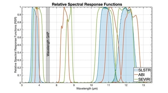
2.2. SLSTR Data
2.3. ABI Data
2.4. SEVIRI Data
2.5. MERRA-2 Data
2.6. RTTOV Simulation
3. Methods
4. Results and Discussion
4.1. Eastern Tropical North Atlantic Ocean Region
4.2. Mediterranean Sea Region
4.3. Cross-Covered Region
5. Conclusions
Author Contributions
Funding
Acknowledgments
Conflicts of Interest
References
- Bentamy, A.; Piollé, J.F.; Grouazel, A.; Danielson, R.; Gulev, S.; Paul, F.; Azelmat, H.; Mathieu, P.P.; von Schuckmann, K.; Sathyendranath, S.; et al. Review and assessment of latent and sensible heat flux accuracy over the global oceans. Remote Sens. Environ. 2017, 201, 196–218. [Google Scholar] [CrossRef]
- Minnett, P.J.; Alvera-Azcárate, A.; Chin, T.M.; Corlett, G.K.; Gentemann, C.L.; Karagali, I.; Li, X.; Marsouin, A.; Marullo, S.; Maturi, E.; et al. Half a century of satellite remote sensing of sea-surface temperature. Remote Sens. Environ. 2019, 233, 111366. [Google Scholar] [CrossRef]
- Luo, B.; Minnett, P.J.; Szczodrak, M.; Kilpatrick, K.; Izaguirre, M. Validation of Sentinel-3A SLSTR derived Sea-Surface Skin Temperatures with those of the shipborne M-AERI. Remote Sens. Environ. 2020, 244, 111826. [Google Scholar] [CrossRef]
- Donlon, C.; Berruti, B.; Buongiorno, A.; Ferreira, M.H.; Féménias, P.; Frerick, J.; Goryl, P.; Klein, U.; Laur, H.; Mavrocordatos, C.; et al. The Global Monitoring for Environment and Security (GMES) Sentinel-3 mission. Remote Sens. Environ. 2012, 120, 37–57. [Google Scholar] [CrossRef]
- Coppo, P.; Ricciarelli, B.; Brandani, F.; Delderfield, J.; Ferlet, M.; Mutlow, C.; Munro, G.; Nightingale, T.; Smith, D.; Bianchi, S.; et al. SLSTR: A high accuracy dual scan temperature radiometer for sea and land surface monitoring from space. J. Mod. Opt. 2010, 57, 1815–1830. [Google Scholar] [CrossRef]
- Mutlow, C.T.; Llewellyn-Jones, D.T.; Závody, A.M.; Barton, I.J. Sea-surface temperature measurements by the Along-Track Scanning Radiometer (ATSR) on ESA’s ERS-1 Satellite—Early results. J. Geophys. Res. 1994, 99, 22575–22588. [Google Scholar] [CrossRef]
- Llewellyn-Jones, D.; Remedios, J. The Advanced Along Track Scanning Radiometer (AATSR) and its predecessors ATSR-1 and ATSR-2: An introduction to the special issue. Remote Sens. Environ. 2012, 116, 1–3. [Google Scholar] [CrossRef]
- Smith, D.L.; Nightingale, T.J.; Mortimer, H.; Middleton, K.; Edeson, R.; Cox, C.V.; Mutlow, C.T.; Maddison, B.J.; Coppo, P. Calibration approach and plan for the sea and land surface temperature radiometer. J. Appl. Remote Sens. 2014, 8, 084980. [Google Scholar] [CrossRef]
- Smith, D.; Barillot, M.; Bianchi, S.; Brandani, F.; Coppo, P.; Etxaluze, M.; Frerick, J.; Kirschstein, S.; Lee, A.; Maddison, B. Sentinel-3A/B SLSTR pre-launch calibration of the thermal infrared channels. Remote Sens. 2020, 12, 2510. [Google Scholar] [CrossRef]
- Schmit, T.J.; Gunshor, M.M.; Menzel, W.P.; Gurka, J.J.; Li, J.; Bachmeier, A.S. Introducing the Next-Generation Advanced Baseline Imager on GOES-R. Bull. Am. Meteorol. Soc. 2005, 86, 1079–1096. [Google Scholar] [CrossRef]
- Aminou, D.M.A. MSG’s SEVIRI instrument. ESA Bull. 2002, 11, 15–17. [Google Scholar]
- Bessho, K.; Date, K.; Hayashi, M.; Ikeda, A.; Imai, T.; Inoue, H.; Kumagai, Y.; Miyakawa, T.; Murata, H.; Ohno, T. An introduction to Himawari-8/9—Japan’s new-generation geostationary meteorological satellites. J. Meteorol. Soc. Jpn. Ser. II 2016, 94, 151–183. [Google Scholar] [CrossRef]
- Minnett, P.J.; Evans, R.H.; Podestá, G.P.; Kilpatrick, K.A. Sea-surface temperature from Suomi-NPP VIIRS: Algorithm development and uncertainty estimation. In Proceedings of the SPIE 9111, Ocean Sensing and Monitoring VI, 91110C, Baltimore, MD, USA, 23 May 2014; p. 91110C. [Google Scholar]
- Yu, F.; Wu, X. Radiometric inter-calibration between Himawari-8 AHI and S-NPP VIIRS for the solar reflective bands. Remote Sens. 2016, 8, 165. [Google Scholar] [CrossRef]
- Liang, X.; Ignatov, A.; Kramar, M.; Yu, F. Preliminary Inter-Comparison between AHI, VIIRS and MODIS Clear-Sky Ocean Radiances for Accurate SST Retrievals. Remote Sens. 2016, 8, 203. [Google Scholar] [CrossRef]
- Salomonson, V.V.; Barnes, W.L.; Maymon, P.W.; Montgomery, H.E.; Ostrow, H. MODIS: Advanced facility instrument for studies of the earth as a system. IEEE Trans. Geosci. Remote Sens. 1989, 27, 145–153. [Google Scholar] [CrossRef]
- Li, Y.; Wu, A.; Xiong, X. Inter-Comparison of S-NPP VIIRS and Aqua MODIS Thermal Emissive Bands Using Hyperspectral Infrared Sounder Measurements as a Transfer Reference. Remote Sens. 2016, 8, 72. [Google Scholar] [CrossRef]
- Wang, L.; Cao, C.; Ciren, P. Assessing NOAA-16 HIRS radiance accuracy using simultaneous nadir overpass observations from AIRS. J. Atmos. Ocean. Technol. 2007, 24, 1546–1561. [Google Scholar] [CrossRef]
- Wang, L.; Tremblay, D.; Zhang, B.; Han, Y. Fast and accurate collocation of the visible infrared imaging radiometer suite measurements with cross-track infrared sounder. Remote Sens. 2016, 8, 76. [Google Scholar] [CrossRef]
- Scarino, B.R.; Doelling, D.R.; Minnis, P.; Gopalan, A.; Chee, T.; Bhatt, R.; Lukashin, C.; Haney, C. A web-based tool for calculating spectral band difference adjustment factors derived from SCIAMACHY hyperspectral data. IEEE Trans. Geosci. Remote Sens. 2016, 54, 2529–2542. [Google Scholar] [CrossRef]
- Wu, A.; Cao, C.; Xiong, X. Intercomparison of the 11-and 12-um bands of Terra and Aqua MODIS using NOAA-17 AVHRR. In Earth Observing Systems VIII, Proceedings of the Optical Science and Technology, SPIE’s 48th Annual Meeting, San Diego, CA, USA, 3–8 August 2003; International Society for Optics and Photonics: Bellingham, WA, USA, 2003; Volume 5151, pp. 384–394. [Google Scholar]
- Merchant, C. SENTINEL-3 Sea Surface Temperature (SLSTR) Algorithm Theoretical Basis Document. Available online: https://www.eumetsat.int/website/wcm/idc/idcplg?IdcService=GET_FILE&dDocName=PDF_S3_L2_ATBD_SLSTR_SST&RevisionSelectionMethod=LatestReleased&Rendition=Web (accessed on 1 August 2020).
- Ignatov, A. GOES-R Advanced Baseline Imager (ABI) Algorithm Theoretical Basis Document for Sea Surface Temperature. 2010. Available online: https://www.star.nesdis.noaa.gov/goesr/documents/ATBDs/Baseline/ATBD_GOES-R_SST-v2.0_Aug2010.pdf:NOAA/NESDIS/STAR (accessed on 1 August 2020).
- Merchant, C.J.; Le Borgne, P.; Roquet, H.; Marsouin, A. Sea surface temperature from a geostationary satellite by optimal estimation. Remote Sens. Environ. 2009, 113, 445–457. [Google Scholar] [CrossRef]
- Romaguera, M.; Sobrino, J.A.; Olesen, F.S. Estimation of sea surface temperature from SEVIRI data: Algorithm testing and comparison with AVHRR products. Int. J. Remote Sens. 2006, 27, 5081–5086. [Google Scholar] [CrossRef]
- Heidinger, A. ABI cloud mask NOAA NESDIS STAR Algorithm Theoretical Basis Doc 2011. Available online: https://www.star.nesdis.noaa.gov/goesr/docs/ATBD/Cloud_Mask.pdf (accessed on 1 August 2020).
- Walton, C.; Pichel, W.; Sapper, J.; May, D. The development and operational application of nonlinear algorithms for the measurement of sea surface temperatures with the NOAA polar-orbiting environmental satellites. J. Geophys. Res. Ocean. 1998, 103, 27999–28012. [Google Scholar] [CrossRef]
- Kilpatrick, K.A.; Podestá, G.; Walsh, S.; Williams, E.; Halliwell, V.; Szczodrak, M.; Brown, O.B.; Minnett, P.J.; Evans, R. A decade of sea surface temperature from MODIS. Remote Sens. Environ. 2015, 165, 27–41. [Google Scholar] [CrossRef]
- Good, E.J.; Kong, X.; Embury, O.; Merchant, C.J.; Remedios, J.J. An infrared desert dust index for the Along-Track Scanning Radiometers. Remote Sens. Environ. 2012, 116, 159–176. [Google Scholar] [CrossRef]
- Merchant, C.J.; Embury, O.; Le Borgne, P.; Bellec, B. Saharan dust in nighttime thermal imagery: Detection and reduction of related biases in retrieved sea surface temperature. Remote Sens. Environ. 2006, 104, 15–30. [Google Scholar] [CrossRef]
- Luo, B.; Minnett, P.J.; Gentemann, C.; Szczodrak, G. Improving satellite retrieved night-time infrared sea surface temperatures in aerosol contaminated regions. Remote Sens. Environ. 2019, 223, 8–20. [Google Scholar] [CrossRef]
- Merchant, C.J.; Harris, A.R.; Murray, J.; Zavody, A.M. Toward the elimination of bias in satellite retrievals of skin sea surface temperature. 1: Theory. modelling and inter-algorithm comparison. J. Geophys. Res. 1999, 104, 23565–23578. [Google Scholar] [CrossRef]
- Minnett, P.J.; Knuteson, R.O.; Best, F.A.; Osborne, B.J.; Hanafin, J.A.; Brown, O.B. The Marine-Atmospheric Emitted Radiance Interferometer (M-AERI), a high-accuracy, sea-going infrared spectroradiometer. J. Atmos. Ocean. Technol. 2001, 18, 994–1013. [Google Scholar] [CrossRef]
- Petrenko, B.; Ignatov, A.; Kihai, Y.; Heidinger, A. Clear-Sky Mask for the Advanced Clear-Sky Processor for Oceans. J. Atmos. Ocean. Technol. 2010, 27, 1609–1623. [Google Scholar] [CrossRef]
- Tjemkes, S.A. On the Conversion from Radiances to Equivalent Brightness Temperatures. 2005. Available online: http://www.eumetsat.int/groups/ops/documents/document/pdf_msg_seviri_rad2bright.pdf (accessed on 1 August 2020).
- Luo, B.; Minnett, P. Evaluation of the ERA5 Sea Surface Skin Temperature with Remotely-Sensed Shipborne Marine-Atmospheric Emitted Radiance Interferometer Data. Remote Sens. 2020, 12, 1873. [Google Scholar] [CrossRef]
- Gelaro, R.; McCarty, W.; Suárez, M.J.; Todling, R.; Molod, A.; Takacs, L.; Randles, C.A.; Darmenov, A.; Bosilovich, M.G.; Reichle, R.; et al. The Modern-Era Retrospective Analysis for Research and Applications, Version 2 (MERRA-2). J. Clim. 2017, 30, 5419–5454. [Google Scholar] [CrossRef] [PubMed]
- Luo, B.; Minnett, P.J.; Szczodrak, M.; Nalli, N.R.; Morris, V.R. Accuracy assessment of MERRA-2 and ERA-Interim sea-surface temperature, air temperature and humidity profiles over the Atlantic Ocean using AEROSE measurements. J. Clim. 2020, 33, 6889–6909. [Google Scholar] [CrossRef]
- Bosilovich, M.G.; Santha, A.; Lawrence, C.; Richard, C.; Clara, D.; Ronald, G.; Robin, K.; Qing, L.; Andrea, M.; Peter, N.; et al. MERRA-2: Initial Evaluation of the Climate; NASA Goddard Space Flight Center: Greenbelt, MA, USA, 2015; p. 145.
- Saunders, R.; Hocking, J.; Turner, E.; Rayer, P.; Rundle, D.; Brunel, P.; Vidot, J.; Roquet, P.; Matricardi, M.; Geer, A. An update on the RTTOV fast radiative transfer model (currently at version 12). Geosci. Model Dev. 2018, 11. [Google Scholar] [CrossRef]
- Sohn, B.J.; Park, H.S.; Han, H.J.; Ahn, M.H. Evaluating the calibration of MTSAT-1R infrared channels using collocated Terra MODIS measurements. Int. J. Remote Sens. 2008, 29, 3033–3042. [Google Scholar] [CrossRef]
- Minobe, S.; Miyashita, M.; Kuwano-Yoshida, A.; Tokinaga, H.; Xie, S.-P. Atmospheric response to the Gulf Stream: Seasonal variations. J. Clim. 2010, 23, 3699–3719. [Google Scholar] [CrossRef]
- Shrestha, A.; Angal, A.; Xiong, X. Evaluation of MODIS and Sentinel-3 SLSTR thermal emissive bands calibration consistency using Dome C. In Algorithms and Technologies for Multispectral, Hyperspectral, and Ultraspectral Imagery XXIV; International Society for Optics and Photonics: Orlando, FL, USA, 2018; Volume 10644, p. 106441U. [Google Scholar]
- Marullo, S.; Santoleri, R.; Ciani, D.; Le Borgne, P.; Péré, S.; Pinardi, N.; Tonani, M.; Nardone, G. Combining model and geostationary satellite data to reconstruct hourly SST field over the Mediterranean Sea. Remote Sens. Environ. 2014, 146, 11–23. [Google Scholar] [CrossRef]
- Marullo, S.; Artale, V.; Santoleri, R. The SST Multidecadal Variability in the Atlantic–Mediterranean Region and Its Relation to AMO. J. Clim. 2011, 24, 4385–4401. [Google Scholar] [CrossRef]
- Marullo, S.; Minnett, P.J.; Santoleri, R.; Tonani, M. The diurnal cycle of sea-surface temperature and estimation of the heat budget of the Mediterranean Sea. J. Geophys. Res. Ocean. 2016, 121, 8351–8367. [Google Scholar] [CrossRef]


| Band | Band | Center Wavelength (μm) | Band | Center Wavelength (μm) | Band | Center Wavelength (μm) |
|---|---|---|---|---|---|---|
| GOES-ABI | MSG-4 SEVIRI | Sentinel-3A SLSTR | ||||
| IR038 | 7 | 3.90 | 4 | 3.90 | S7 | 3.74 |
| IR087 | 11 | 8.50 | 7 | 8.70 | - | - |
| IR112 | 14 | 11.20 | 9 | 10.80 | S8 | 10.95 |
| IR123 | 15 | 12.30 | 10 | 12.00 | S9 | 12.00 |
| Satellite | Available from | Temporal Resolution | Spatial Resolution |
|---|---|---|---|
| Sentinel-3A SLSTR | EUMETSAT Copernicus Online Data Access (CODA) | every 3 min for Level-1B data | 1 km |
| GOES-ABI | NOAA Amazon Web Services (AWS) Data Centre | every 10 min | 1 km |
| MSG-4 SEVIRI | EUMETSAT Data Centre | every 15 min | 3 km |
| Areas | for | Date | UTC Time |
|---|---|---|---|
| Eastern tropical North Atlantic Ocean | SLSTR with ABI | 1 January 2020 | Day: 15:21:14 PM Night: 02:55:20 AM |
| Mediterranean Sea | SLSTR with SEVIRI | 23 December 2019 | Day: 09:04:56 AM Night: 20:21:51 PM |
| Cross-covered region | SLSTR with SEVIRI and ABI | 27 November 2019 | Day: 12:09:44 AM Night: 00:36:20 AM |
| Eastern Tropical North Atlantic Ocean | Day/Night | Band (SLSTR) | Mean (K) | Median (K) | STD (K) | RSD (K) |
|---|---|---|---|---|---|---|
| SLSTR vs ABI | Day | S7 | 0.028 | −0.005 | 0.296 | 0.248 |
| S8 | 0.054 | 0.008 | 0.326 | 0.145 | ||
| S9 | 0.042 | 0.006 | 0.401 | 0.260 | ||
| Night | S7 | 0.039 | −0.033 | 0.360 | 0.281 | |
| S8 | 0.079 | 0.028 | 0.383 | 0.230 | ||
| S9 | −0.035 | −0.088 | 0.360 | 0.330 |
| Mediterranean Sea | Day/Night | Band (SLSTR) | Mean (K) | Median (K) | STD (K) | RSD (K) |
|---|---|---|---|---|---|---|
| SLSTR vs SEVIRI | Day | S7 | 0.133 | 0.045 | 0.544 | 0.493 |
| S8 | 0.067 | −0.005 | 0.454 | 0.143 | ||
| S9 | 0.073 | 0.008 | 0.440 | 0.198 | ||
| Night | S7 | 0.077 | 0.012 | 0.480 | 0.320 | |
| S8 | 0.143 | −0.003 | 0.674 | 0.240 | ||
| S9 | 0.124 | −0.003 | 0.644 | 0.328 |
| Cross-Covered Region | Day/Night | Band (SLSTR) | Mean (K) | Median (K) | STD (K) | RSD (K) |
|---|---|---|---|---|---|---|
| SLSTR vs ABI | Day | S8 | 0.035 | 0.013 | 0.452 | 0.184 |
| S9 | 0.056 | 0.030 | 0.516 | 0.211 | ||
| Night | S8 | 0.128 | 0.036 | 0.891 | 0.186 | |
| S9 | 0.143 | 0.025 | 1.084 | 0.207 | ||
| SLSTR vs SEVIRI | Day | S8 | 0.087 | 0.018 | 0.450 | 0.202 |
| S9 | 0.072 | 0.010 | 0.467 | 0.241 | ||
| Night | S8 | 0.084 | 0.014 | 0.465 | 0.224 | |
| S9 | 0.105 | 0.024 | 0.549 | 0.265 |
© 2020 by the authors. Licensee MDPI, Basel, Switzerland. This article is an open access article distributed under the terms and conditions of the Creative Commons Attribution (CC BY) license (http://creativecommons.org/licenses/by/4.0/).
Share and Cite
Luo, B.; Minnett, P.J. Comparison of SLSTR Thermal Emissive Bands Clear-Sky Measurements with Those of Geostationary Imagers. Remote Sens. 2020, 12, 3279. https://doi.org/10.3390/rs12203279
Luo B, Minnett PJ. Comparison of SLSTR Thermal Emissive Bands Clear-Sky Measurements with Those of Geostationary Imagers. Remote Sensing. 2020; 12(20):3279. https://doi.org/10.3390/rs12203279
Chicago/Turabian StyleLuo, Bingkun, and Peter J. Minnett. 2020. "Comparison of SLSTR Thermal Emissive Bands Clear-Sky Measurements with Those of Geostationary Imagers" Remote Sensing 12, no. 20: 3279. https://doi.org/10.3390/rs12203279
APA StyleLuo, B., & Minnett, P. J. (2020). Comparison of SLSTR Thermal Emissive Bands Clear-Sky Measurements with Those of Geostationary Imagers. Remote Sensing, 12(20), 3279. https://doi.org/10.3390/rs12203279