Bridging the Semantic Gap between Land Tenure and EO Data: Conceptual and Methodological Underpinnings for a Geospatially Informed Analysis
Abstract
1. Introduction
- Which kind of land tenure-related data can one derive and acquire when information access is limited?
- Which proxies can help to derive currently unknown land tenure relations in conjunction with EO data?
2. Fundamentals of EO data Applications for Identifying Land Tenure Relations
2.1. The Conceptual Models of Semantic Land Tenure Relations
2.2. Advancement of EO and AI Applications in Identifying Land Tenure Relations
3. Methodological considerations
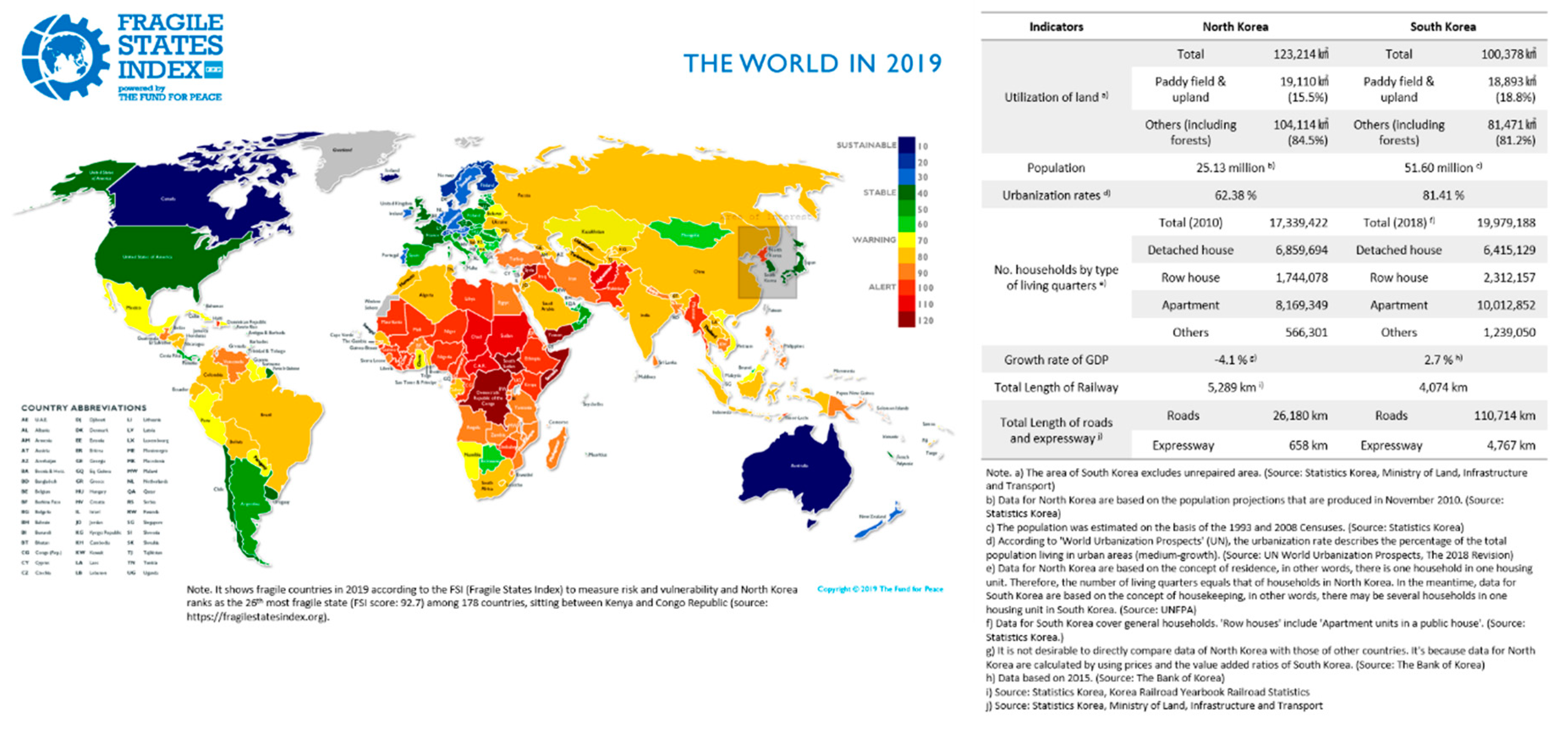
3.1. A Difficult-to-Access Region: North Korea in the Contexts of Fragile and Conflict-Affected Areas
3.2. Existing Rules for Defining Land Tenure Relations and LULC classifications
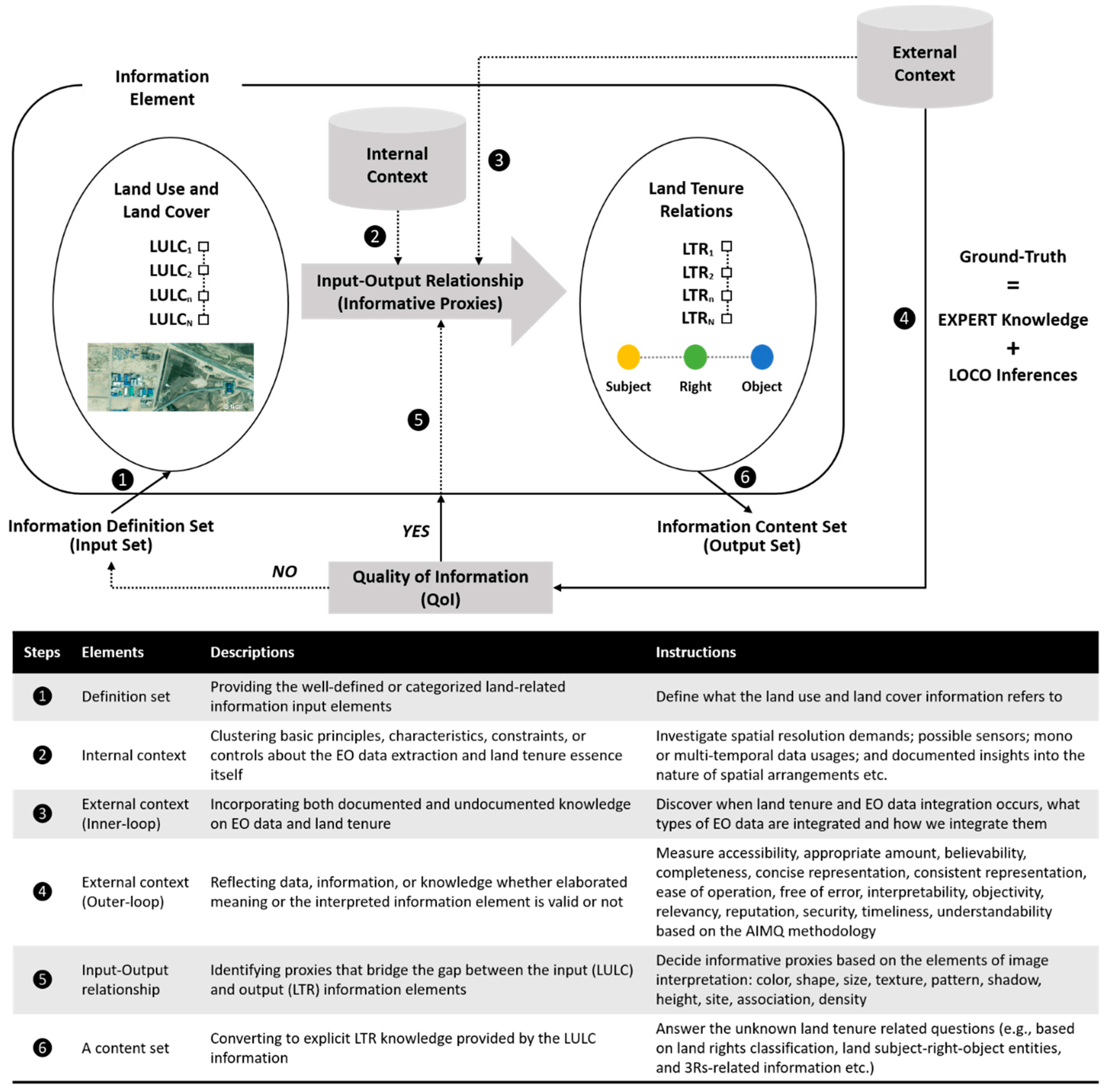
3.3. Adopting a New Methodology: Mixed Methods Design and Information Fusion Approach
4. Deriving Workable EO Data Proxies for Interpreting Land Tenure Relations
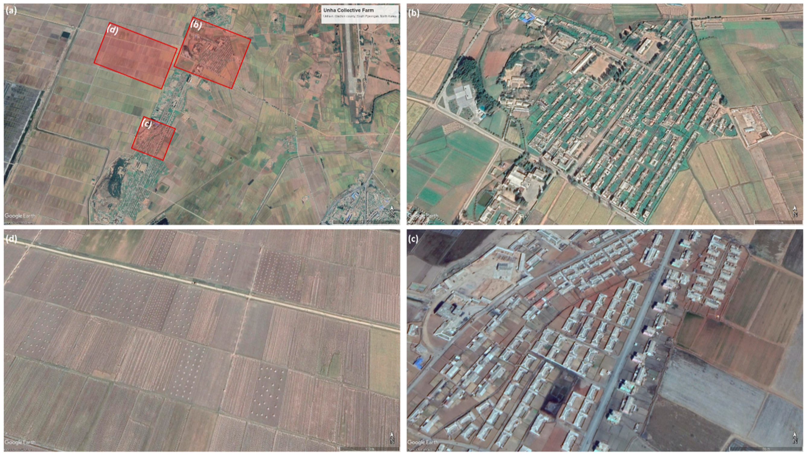
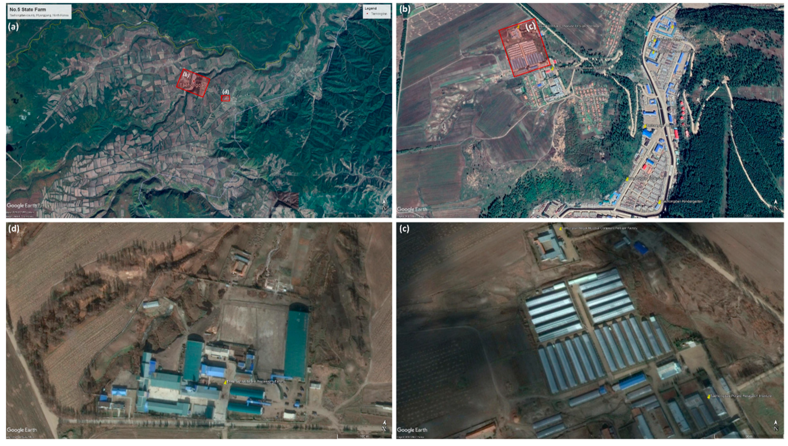
4.1. Is It Possible to Distinguish Collective Farmland from State Land?
4.2. Can One See Land Use Rights (LURs)?
4.3. Is There a Use Right that Can be Linked to an Individual or Group?
4.4. Are There Land Transfer Rights (LTRs)?
4.5. Are There a Land Access Rights (LARs) and Restrictions?
4.6. Summary of Discussion
5. Concluding Remarks
Author Contributions
Funding
Acknowledgments
Conflicts of Interest
References
- Robinson, B.E.; Holland, M.B.; Naughton-Treves, L. Does secure land tenure save forests? A meta-analysis of the relationship between land tenure and tropical deforestation. Glob. Environ. Chang. 2014, 29, 281–293. [Google Scholar] [CrossRef]
- Payne, G.; Durand-Lasserve, A. Holding on: Security of Tenure-Types, Policies, Practices and Challenges. Research Paper Prepared for an Expert Group Meeting of Tenure Convened by the United Nations Special Rapporteur on Adequate Housing, October 2012. Available online: https://www.ohchr.org/Documents/Issues/Housing/SecurityTenure/Payne-Durand-Lasserve-BackgroundPaper-JAN2013.pdf (accessed on 18 January 2019).
- Petersen, R.; Stevens, C. Putting People on the Map: The Land Tenure Data Challenge and Global Forest Watch. Global Forest Watch. Available online: https://blog.globalforestwatch.org/data-and-research/land-tenure-gfw (accessed on 2 October 2018).
- Chaturvedi, R.; Shelar, K.; Singh, K.K. MAPTenure: Enabling Tenurial Clarity for Orange Areas of Central India; WRI: Mumbai, India, 2018. [Google Scholar]
- Biscaye, P.; Callaway, K.; Chen, K.; McDonald, M.; Morton, E.; Reynolds, T.; Anderson, L. Land Tenure Technologies Summary of Services and Implementation; Evans School Policy Analysis and Research (EPAR): Washington, DC, USA, 2017. [Google Scholar]
- Schweik, C.M.; Thomas, C.W. Using Remote Sensing to Evaluate Environmental Institutional Designs: A Habitat Conservation Planning Example. Soc. Sci. Q. 2002, 83, 244–262. [Google Scholar] [CrossRef]
- Hall, O. Remote sensing in social science research. Open Remote Sens. J. 2010, 3, 1–16. [Google Scholar] [CrossRef]
- Donaldson, D.; Storeygard, A. The View from Above: Applications of Satellite Data in Economics. J. Econ. Perspect. 2016, 30, 171–198. [Google Scholar] [CrossRef]
- Patino, J.E.; Duque, J.C. A review of regional science applications of satellite remote sensing in urban settings. Comput. Environ. Urban Syst. 2013, 37, 1–17. [Google Scholar] [CrossRef]
- Crommelinck, S.; Bennett, R.; Gerke, M.; Nex, F.; Yang, M.; Vosselman, G. Review of Automatic Feature Extraction from High-Resolution Optical Sensor Data for UAV-Based Cadastral Mapping. Remote Sens. 2016, 8, 689. [Google Scholar] [CrossRef]
- Crommelinck, S.; Bennett, R.; Gerke, M.; Yang, M.; Vosselman, G. Contour Detection for UAV-Based Cadastral Mapping. Remote Sens. 2017, 9, 171. [Google Scholar] [CrossRef]
- Crommelinck, S.; Koeva, M.; Yang, M.Y.; Vosselman, G. Application of Deep Learning for Delineation of Visible Cadastral Boundaries from Remote Sensing Imagery. Remote Sens. 2019, 11, 2505. [Google Scholar] [CrossRef]
- Fetai, B.; Oštir, K.; Kosmatin Fras, M.; Lisec, A. Extraction of Visible Boundaries for Cadastral Mapping Based on UAV Imagery. Remote Sens. 2019, 11, 1510. [Google Scholar] [CrossRef]
- Konecny, G. Cadastral Mapping with Earth Observation Technology. In Geospatial Technology for Earth Observation; Li, D., Shan, J., Gong, J., Eds.; Springer: Boston, MA, USA, 2009; pp. 397–409. [Google Scholar] [CrossRef]
- Luo, X.; Bennett, R.; Koeva, M.; Lemmen, C.; Quadros, N. Quantifying the Overlap between Cadastral and Visual Boundaries: A Case Study from Vanuatu. Urban Sci. 2017, 1, 32. [Google Scholar] [CrossRef]
- Luo, X.; Bennett, R.M.; Koeva, M.; Lemmen, C. Investigating Semi-Automated Cadastral Boundaries Extraction from Airborne Laser Scanned Data. Land 2017, 6, 60. [Google Scholar] [CrossRef]
- Nyandwi, E.; Koeva, M.; Kohli, D.; Bennett, R. Comparing Human Versus Machine-Driven Cadastral Boundary Feature Extraction. Remote Sens. 2019, 11, 1662. [Google Scholar] [CrossRef]
- Wassie, Y.A.; Koeva, M.N.; Bennett, R.M.; Lemmen, C.H.J. A procedure for semi-automated cadastral boundary feature extraction from high-resolution satellite imagery. J. Spat. Sci. 2018, 63, 75–92. [Google Scholar] [CrossRef]
- Xia, X.; Persello, C.; Koeva, M. Deep Fully Convolutional Networks for Cadastral Boundary Detection from UAV Images. Remote Sens. 2019, 11, 1725. [Google Scholar] [CrossRef]
- Lambin, E.F.; Turner, B.L.; Geist, H.J.; Agbola, S.B.; Angelsen, A.; Bruce, J.W.; Coomes, O.T.; Dirzo, R.; Fischer, G.; Folke, C.; et al. The causes of land-use and land-cover change: Moving beyond the myths. Glob. Environ. Chang. 2001, 11, 261–269. [Google Scholar] [CrossRef]
- Cumming, G.S.; Barnes, G. Characterizing land tenure dynamics by comparing spatial and temporal variation at multiple scales. Landsc. Urban Plan. 2007, 83, 219–227. [Google Scholar] [CrossRef]
- Donnelly, S.; Evans, T.P. Characterizing spatial patterns of land ownership at the parcel level in south-central Indiana, 1928–1997. Landsc. Urban Plan. 2008, 84, 230–240. [Google Scholar] [CrossRef]
- National Research Council. People and Pixels: Linking Remote Sensing and Social Science; The National Academies Press: Washington, DC, USA, 1998. [Google Scholar] [CrossRef]
- Liu, X.; He, J.; Yao, Y.; Zhang, J.; Liang, H.; Wang, H.; Hong, Y. Classifying urban land use by integrating remote sensing and social media data. Int. J. Geogr. Inf. Sci. 2017, 31, 1675–1696. [Google Scholar] [CrossRef]
- Bennett, R.; Kitchingman, A.; Leach, J. On the nature and utility of natural boundaries for land and marine administration. Land Use Policy 2010, 27, 772–779. [Google Scholar] [CrossRef]
- Whittal, J. A new conceptual model for the continuum of land rights. S. Afr. J. Geomat. 2014, 3, 13–32. [Google Scholar]
- Herrera, M. Land Tenure Data and Policy Making in Latin America. In Proceedings of the Conclusive Expert Meeting on FAO Normative Work on Land Tenure Data, Rome, Italy, 22–23 September 2005. [Google Scholar]
- Bratasanu, D.; Nedelcu, I.; Datcu, M. Bridging the Semantic Gap for Satellite Image Annotation and Automatic Mapping Applications. IEEE J. Sel. Top. Appl. Earth Obs. Remote Sens. 2011, 4, 193–204. [Google Scholar] [CrossRef]
- Yang, D.; Fu, C.-S.; Smith, A.C.; Yu, Q. Open land-use map: A regional land-use mapping strategy for incorporating OpenStreetMap with earth observations. Geospat. Inf. Sci. 2017, 20, 269–281. [Google Scholar] [CrossRef]
- Henssen, J. Basic Principles of the Main Cadastral Systems in the World, Modern Cadastres and Cadastral Innovations. In Proceedings of the One Day Seminar Held During the Annual Meeting of FIG Commission 7, Cadastre and Rural Land Management, International Federation of Surveyors (FIG), Delft, The Netherlands, 16 May 1995; pp. 5–12. [Google Scholar]
- Zevenbergen, J.A.; Frank, A.; Stubkjaer, E. Real Property Transactions: Procedures, Transaction Costs and Models; IOS Press: Amsterdam, The Netherlands, 2007. [Google Scholar]
- Van der Molen, P. The Future Cadastres—Cadastres After 2014. In Proceedings of the FIG Working Week 2003, Paris, France, 13–17 April 2003. [Google Scholar]
- Lemmen, C.; van Oosterom, P.; Bennett, R. The Land Administration Domain Model. Land Use Policy 2015, 49, 535–545. [Google Scholar] [CrossRef]
- Lemmen, C.H.J. A Domain Model for Land Administration. Ph.D. Thesis, Delft University of Technology, Delft, The Netherlands, 2012. Available online: http://www.itc.nl/library/papers_2012/phd/lemmen.pdf (accessed on 29 March 2019).
- UN-Habitat. Secure Land Rights for All; UN Habitat: Nairobi, Kenya, 2008. [Google Scholar]
- Enemark, S.; Bell, K.C.; Lemmen, C.; McLaren, R. Fit-For-Purpose Land Administration; International Federation of Surveyors (FIG): Copenhagen, Denmark, 2014. [Google Scholar]
- Zevenbergen, J.; De Vries, W.; Bennett, R.M. Advances in Responsible Land Administration; CRC Press: Boca Raton, FL, USA, 2015. [Google Scholar]
- Ma, L.; Liu, Y.; Zhang, X.; Ye, Y.; Yin, G.; Johnson, B.A. Deep learning in remote sensing applications: A meta-analysis and review. ISPRS J. Photogramm. Remote Sens. 2019, 152, 166–177. [Google Scholar] [CrossRef]
- Levin, N.; Ali, S.; Crandall, D. Utilizing remote sensing and big data to quantify conflict intensity: The Arab Spring as a case study. Appl. Geogr. 2018, 94, 1–17. [Google Scholar] [CrossRef]
- Schoepfer, E.; Spröhnle, K.; Kranz, O.; Blaes, X.; Kolomaznik, J.; Hilgert, F.; Bartalos, T.; Kemper, T. Towards a multi-scale approach for an Earth observation-based assessment of natural resource exploitation in conflict regions. Geocarto Int. 2017, 32, 1139–1158. [Google Scholar] [CrossRef]
- Gbanie, S.; Griffin, A.; Thornton, A. Impacts on the urban environment: Land cover change trajectories and landscape fragmentation in Post-War Western Area, Sierra Leone. Remote Sens. 2018, 10, 129. [Google Scholar] [CrossRef]
- World Bank. Why Are Some Data Not Available? Available online: https://datahelpdesk.worldbank.org/knowledgebase/articles/191133-why-are-some-data-not-available (accessed on 21 September 2019).
- Lee, C.; de Vries, W.T. A divided nation: Rethinking and rescaling land tenure in the Korean (re-)unification. Land Use Policy 2018, 75, 127–136. [Google Scholar] [CrossRef]
- Lee, C.; de Vries, W.T.; Chigbu, U.E. Land Governance Re-Arrangements: The One-Country One-System (OCOS) Versus One-Country Two-System (OCTS) Approach. Adm. Sci. 2019, 9, 21. [Google Scholar] [CrossRef]
- Gyeon, Y.; Lee, S. North Korea Forum Seminar: Collection and Management of North Korea Data and Statistics. Plan. Policy 2006, 292, 102–107. [Google Scholar]
- United Nations. UN Entities in DPR Korea. Available online: https://dprkorea.un.org/about/un-entities-in-country (accessed on 23 September 2019).
- He, J.; Xu, J. Is there decentralization in North Korea? Evidence and lessons from the sloping land management program 2004–2014. Land Use Policy 2017, 61, 113–125. [Google Scholar] [CrossRef]
- Kim, N.; Lee, J.; Lee, H.; Seo, J. Accurate segmentation of land regions in historical cadastral maps. J. Vis. Commun. Image Represent. 2014, 25, 1262–1274. [Google Scholar] [CrossRef]
- Lee, H.; Lee, S.; Kim, N.; Seo, J. JigsawMap: Connecting the past to the future by mapping historical textual cadasters. In Proceedings of the SIGCHI Conference on Human Factors in Computing Systems, Austin, TX, USA, 5–10 May 2012; pp. 463–472. [Google Scholar]
- Ko, Y.; Yun, H. Analysis of Land Use in North Korea Using the Original of Cadastral Map. J. Korean Soc. Cadastre 2016, 32, 49–57. [Google Scholar]
- Yu, J.; Lim, J.; Lee, K.-S. Investigation of drought-vulnerable regions in North Korea using remote sensing and cloud computing climate data. Environ. Monit. Assess. 2018, 190, 126. [Google Scholar] [CrossRef]
- Um, D.-B.; Um, J.-S. Informed consent utilizing satellite imagery in forestry carbon trading with North Korea. Int. Environ. Agreem. Politics Law Econ. 2017, 17, 531–552. [Google Scholar] [CrossRef]
- Lim, J.; Lee, K.-S. Flood Mapping Using Multi-Source Remotely Sensed Data and Logistic Regression in the Heterogeneous Mountainous Regions in North Korea. Remote Sens. 2018, 10, 1036. [Google Scholar] [CrossRef]
- Lim, J.; Lee, K.-S. Investigating flood susceptible areas in inaccessible regions using remote sensing and geographic information systems. Environ. Monit. Assess. 2017, 189, 96. [Google Scholar] [CrossRef]
- Ernst, M.; Jurowetzki, R. Satellite Data, Women Defectors and Black Markets in North Korea: A Quantitative Study of the North Korean Informal Sector Using Night-Time Lights Satellite Imagery. North Korean Rev. 2016, 12, 64–83. [Google Scholar]
- Lim, H.-T.; Yang, S.-C.; Lee, S.-H.; Shin, D.-B.; Ahn, J.-W. An Experimental Project on Land Information Establishment in North Korea Regarding Rapid Unification; LX Spaital Information Research Institute: Seoul, Korea, 2015. [Google Scholar]
- Lee, B.-M.; Kim, T.-J.; Kwak, B.-Y.; Lee, Y.-H.; Choi, J. Improvement of the Korean LADM country profile to build a 3D cadastre model. Land Use Policy 2015, 49, 660–667. [Google Scholar] [CrossRef]
- Choi, J.-H.; Kim, B.-J.; Shim, J.-W. A Study on Improvement of Land Characteristic Survey; KAB Real Estate Research & Development Institute: Daegu, Korea, 2015. [Google Scholar]
- LX Spatial Information Research Institute. Study on Efficient Implementation of Cadastral Resurvey Project—Improvement of Land Category System by Land Use; Ministry of Land, Transport and Maritime Affairs: Gwacheon, Korea, 2012.
- Jensen, J.R.; Cowen, D.C. Remote sensing of urban suburban infrastructure and socio-economic attributes. Photogramm. Eng. Remote Sens. 1999, 65, 611–622. [Google Scholar]
- Ramankutty, N.; Graumlich, L.; Achard, F.; Alves, D.; Chhabra, A.; DeFries, R.S.; Foley, J.A.; Geist, H.; Houghton, R.A.; Goldewijk, K.K.; et al. Global Land-Cover Change: Recent Progress, Remaining Challenges. In Land-Use and Land-Cover Change: Local Processes and Global Impacts; Lambin, E.F., Geist, H., Eds.; Springer: Berlin/Heidelberg, Germany, 2006; pp. 9–39. [Google Scholar] [CrossRef]
- Wickham, J.; Stehman, S.V.; Homer, C.G. Spatial patterns of the United States National Land Cover Dataset (NLCD) land-cover change thematic accuracy (2001–2011). Int. J. Remote Sens. 2018, 39, 1729–1743. [Google Scholar] [CrossRef] [PubMed]
- Lymburner, L.; Tan, P.; Mueller, N.; Thackway, R.; Lewis, A.; Thankappan, M.; Randall, L.; Islam, A.; Senarath, U. The national dynamic land cover dataset - Technical Report; Record 2011/031; Geoscience Australia: Canberra, Australia, 2011. Available online: http://pid.geoscience.gov.au/dataset/ga/71069 (accessed on 5 April 2019).
- Büttner, G. CORINE Land Cover and Land Cover Change Products. In Land Use and Land Cover Mapping in Europe: Practices & Trends; Manakos, I., Braun, M., Eds.; Springer: Dordrecht, The Netherlands, 2014; pp. 55–74. [Google Scholar] [CrossRef]
- Zhang, Z.; Wang, X.; Zhao, X.; Liu, B.; Yi, L.; Zuo, L.; Wen, Q.; Liu, F.; Xu, J.; Hu, S. A 2010 update of National Land Use/Cover Database of China at 1:100,000 scale using medium spatial resolution satellite images. Remote Sens. Environ. 2014, 149, 142–154. [Google Scholar] [CrossRef]
- Bryman, A. Social Research Methods; Oxford University Press: Oxford, UK, 2016. [Google Scholar]
- Fielding, N.G. Triangulation and Mixed Methods Designs: Data Integration with New Research Technologies. J. Mixed Methods Res. 2012, 6, 124–136. [Google Scholar] [CrossRef]
- Larsson, G. Land Management: Public Policy, Control and Participation; Coronet Books: London, UK, 1997. [Google Scholar]
- Payne, G. Land tenure and property rights: An introduction. Habitat Int. 2004, 28, 167–179. [Google Scholar] [CrossRef]
- Fox, J.; Rindfuss, R.R.; Walsh, S.J.; Mishra, V. People and the Environment: Approaches for Linking Household and Community Surveys to Remote Sensing and GIS; Springer Science & Business Media: Berlin, Germany, 2003; Volume 1. [Google Scholar]
- Ghaffarian, S.; Kerle, N.; Filatova, T. Remote Sensing-Based Proxies for Urban Disaster Risk Management and Resilience: A Review. Remote Sens. 2018, 10, 1760. [Google Scholar] [CrossRef]
- Ghazouani, F.; Farah, I.R.; Solaiman, B. Semantic remote sensing scenes interpretation. In Ontology in Information Science; IntechOpen: London, UK, 2018. [Google Scholar]
- Bosse, E.; Roy, J.; Wark, S. Concepts, Models, and Tools for Information Fusion; Artech House Inc.: Norwood, MA, USA, 2007. [Google Scholar]
- Altaweel, M.R.; Alessa, L.N.; Kliskey, A.D.; Bone, C.E. Monitoring Land Use: Capturing Change through an Information Fusion Approach. Sustainability 2010, 2, 1182–1203. [Google Scholar] [CrossRef]
- Bossé, É.; Solaiman, B. Information Fusion and Analytics for Big Data and IoT; Artech House: Norwood, MA, USA, 2016. [Google Scholar]
- Kim, Y.-H. Changes in Agricultural Farms in North Korea—Focusing on Cooperative Farms. Q. Agric. Trends North Korea 2010, 12, 3–17, UCI: I410-ECN-0102-2018-500-004168983. [Google Scholar]
- Kosztra, B.; Büttner, G.; Hazeu, G.; Arnold, S. Updated CLC Illustrated Nomenclature Guidelines; European Environmental Agency: Copenhagen, Denmark, 2017. [Google Scholar]
- Choi, W.; Kang, S.; Choi, J.; Larsen, J.J.; Oh, C.; Na, Y.-G. Characteristics of deforestation in the Democratic People’s Republic of Korea (North Korea) between the 1980s and 2000s. Reg. Environ. Chang. 2017, 17, 379–388. [Google Scholar] [CrossRef]
- Kim, Y.-H.; Kwon, T.-J.; Lim, S.-K.; Choi, S.-K. A Study on North Korea’s Agricultural Reform Measures after the Economic Crisis; Korea Rural Economic Institute: Jeollanam-do, Korea, 2013; pp. 1–146. [Google Scholar]
- Kim, C.S. DPR Korea 2008 Population Census National Report; Central Bureau of Statistics: Pyongyang, DPR Korea, 2009.
- Choi, S.-H.; Choi, D.-S.; Lee, J.-K.; Hong, S.-W. North Korea Housing Survey and Analysis; Land and Housing Institute: Deajeon, Korea, 2015. [Google Scholar]
- Reenberg, A.; Lund, C. Land Use and Land Right Dynamics—Determinants for Resource Management Options in Eastern Burkina Faso. Hum. Ecol. 1998, 26, 599–620. [Google Scholar] [CrossRef]
- Hettig, E.; Lay, J.; Sipangule, K. Drivers of Households’ Land-Use Decisions: A Critical Review of Micro-Level Studies in Tropical Regions. Land 2016, 5, 32. [Google Scholar] [CrossRef]
- Lim, S.H. Coexistence of Planning and Markets; Samsung Economic Research Institute: Seoul, Korea, 2008. [Google Scholar]
- Stoter, J.E.; van Oosterom, P. 3D Cadastre in an International Context: Legal, Organizational, and Technological Aspects; CRC Press: Boca Raton, FL, USA, 2006. [Google Scholar]
- Li, J.; Huang, X.; Gong, J. Deep neural network for remote-sensing image interpretation: Status and perspectives. Natl. Sci. Rev. 2019. [Google Scholar] [CrossRef]
| Semantic Land Tenure Relations | Land Tenure Data Specification | EO Data Application |
|---|---|---|
| Subject-Right-Object Model [30] | The model only distinct three categories: “subject-rights-objects”. Subjects are persons, groups, firms or States. Rights are ownership, use, control, access and transfer rights. Objects are physical features. The model puts in principle the accent on the relation “subject-right (who and how)”, and on the relation on “right-object (where and how much)”. | Scalability: currently EO data only looks at physical objects. This includes identifying cadastral (parcel and building) boundary-mapping approaches and land use attributes. However, other attributes can be derived using technical advances of Earth Observation (EO). |
| Land Administration Domain Model (LADM) [33] | The Land Administration Domain Model (LADM) facilitates the management of different tenures in “one environment”; it covers all land tenure-related data components including parties (person or organization), legal/administrative units (right, responsibility and restrictions), spatial objects (parcel, buildings and utility networks), and data on surveying and spatial representation (geometric/topological data). | Inter-operability: to capture semantics of the land administration and data-related components, a range of data acquisition methods is emphasized (e.g., satellite images, Unmanned Aerial Vehicles (UAVs) and automatic feature extraction). |
| Continuum of Land Rights [35] | It refers to recognizing, recording, administering a variety of appropriate and legitimate land tenure data. It, thus, focuses on the “tenurial pluralism” (diversity of tenure arrangements) and duality in subjects. | Flexibility: underlining importance of data robustness and accuracies using more sophisticated technologies to systemically accumulate land tenure data |
| Fit-For-Purpose Land Administration [36] | Capturing spatial land tenure data should be “flexible and participatory” that covers all tenure data in scope. Moreover, acquired land tenure data is used affordable technologies and needs to provide adequate reliability within a limited time and resources. All land tenure data should be kept up-to-date. | Accuracy: application of general boundary mapping (rural); the use of high resolution satellite imagery (urban); high accuracy of information; on-going updating, sporadic upgrading and incremental improvement |
| Responsible Land Administration [37] | It addresses changes in people to land relations based on “socio-technical and institutional advances”. New geoICT-driven and thought-restructuring land data capture, visualization, and sharing techniques with a clear understanding of a legal, organizational, and governance context can acquire specific characteristics of land tenure. | Legitimacy: emerging geospatial technologies including high-resolution satellite imagery for data collection and management offers new insights on legitimizing land rights and documentation as well as acknowledging different forms of land tenure. |
| Technologies | Techniques | Sources | ||
|---|---|---|---|---|
| EO | AI | |||
| CV | DL | |||
| Aerial imagery (Orthophoto) | No | No | Cadastral morphology investigation: visual interpretation from the overlay of the cadastral map over orthophotos | [15] |
| Airborne Laser Scanning (ALS) | √ | Semi-automatic boundary extraction: Alpha shape (α-shapes), Canny, and Skeleton algorithm | [16] | |
| Unmanned Aerial Vehicles (UAVs) | √ | Automatic feature extraction: Globalized Probability of Boundary (gPb) contour detections | [11] | |
| High Resolution Satellite Imagery (HRSI) | √ | Semi-automatic boundary feature extraction: mean-shift segmentation plug-in QGIS, the buffer overlay methods | [18] | |
| Unmanned Aerial Vehicles (UAVs) | √ | Automatic boundary extraction: ENVI feature extraction (FX) module | [13] | |
| High Resolution Satellite Imagery (HRSI) | √ | Automatic boundary extraction: Multi-Resolution Segmentation (MRS), estimation of scale parameter (ESP) | [17] | |
| Unmanned Aerial Vehicles (UAVs) | √ | Automatic cadastral boundary detection: deep Fully Convolutional Networks (FCNs) | [19] | |
| Aerial imagery and UAVs | √ | Automatic boundary classification: Random Forest (RF), Convolutional Neural Networks (CNN) | [12] | |
| Categories | Existing Rules for Identifying Land Tenure Relations in SK | Existing Rules for Identifying Land Tenure Relations in NK | Legal Grounds |
|---|---|---|---|
| 3Rs (rights, responsibility and restrictions) | Private land; State land; province land; county land; land owned by corporation (judicial person); land owned by a clan; land owned by a religious group; land owned by other groups; others (9 types)Common ownership; lease; ownership; partitioned ownership; tenancy; superficies; partitioned superficies; usufruct; easement; fishing; keeping a snow-free pavement; cleaning a ditch; servitude; servitude partly (14 types) | State land; collective farmland (2 types)(cf. Since North Korea does not recognize private ownership; there is no land use regulation through the restriction of private rights. Although all land belongs to the State, both the State and the individual or collective can restrict the use by restricting the access. Nature reserves, military sites, public heritage are typically locations where the State wants to restrict access, use and control through such restrictions.) | The Constitution (NK) The Civil Law (NK) The Civil Act (SK) LADM (SK); |
| Land (use) categories | Building site; dry paddy-field; paddy-field; orchard; forestry; pasture site; mineral spring site; saltern; factory site; school site; parking lot; gas station site; warehouse site; road; railway site; water supply site; river; ditch; fish-farm; park; historic site; gymnasium site; recreation area; religious site; graveyard; miscellaneous land (28 types) | Agricultural-purpose land (arable land); settlement land (construction land and its attached land in local labor areas as well as public land); forestry land (land used in the hills and fields); industry land (sites of industrial facilities such as mine, factories, and the land pertaining to it); waterstock land (land for coast, territorial waters, river and streams, lake, reservoir and irrigation ditch); special-purpose land (cultural heritage sites, historical landmarks, sanctuary and military) (6 types) | The Act on the Establishment, Management, etc. of Spatial data (SK); The Land Law (NK) |
| Land (use) characteristics | detached-house lot, row-house lot, multiplex-house lot, apartment lot, residential vacant lot, other residential lots; commercial lot, office lot, commercial/office lot, other commercial/office lots; mixed-use lot, mixed-use vacant lot, other mixed-used lots; industrial lot, industrial vacant lot, other industrial lots; dry paddy-field, orchard, other dry paddy-fields; paddy-field, other paddy-fields; afforestation, natural forest, forest land, pasture, other forestry; mineral spring site, mining site, saltern site, recreation area, cemetery park, golf course, racecourse, passenger transport terminal, condominium, other special-purpose lands; roads etc., rivers etc., parks etc., playgrounds etc., parking lot etc., high-risk establishments, obnoxious facilities and Others (45 types) | Agricultural-purpose land (arable land); settlement land (construction land and its attached land in local labor areas as well as public land); forestry land (land used in the hills and fields); industry land (sites of industrial facilities such as mine, factories, and the land pertaining to it); waterstock land (land for coast, territorial waters, river and streams, lake, reservoir and irrigation ditch); special-purpose land (cultural heritage sites, historical landmarks, sanctuary and military) (6 types) | The Act on the Public Announcement of Values and Appraisal of Real Estate (SK); The Land Law (NK) |
| Land (use) infrastructure | Road; park; railway; (public) open space; waste treatment facilities and water-pollution preventive facilities; heat/gas/oil supplying and storing installations; electric supplying installations; slaughterhouse; graveyards; markets and distribution facilities; recreation area; parking lot; car stations; square; playground and sport facilities; water supplying instalments; public buildings (e.g., school and library); communication facilities; cultural, research, social welfare, public vocational training, youth training facilities, others (21 types) | Dwelling house; public buildings; production buildings; water supplying instalments; heat/gas/oil supplying facilities; road; street green; footpath; streetlight; bridge; tunnel; underground passage; road safety facilities; road markings; bus/tram station; car washing facilities; river (stream); park; recreation area; open space; urban forest; protection forest; zoo/botanical gardens; greenhouse; tree nursery; flower garden; cultural facilities; sanitation facilities; cremation facilities (assumed 29 types) | The National Land Planning And Utilization Act (SK); The Urban Management Law (NK) |
| No. | Land Tenure Relations | Proposed Proxies | Elements of EO Data Interpretation | ||||||||||||||
|---|---|---|---|---|---|---|---|---|---|---|---|---|---|---|---|---|---|
| 4.1 | Collective (farm) land | Presence of (dry) paddy fields | |||||||||||||||
| Area linked to or surrounded by (dry) paddy fields | |||||||||||||||||
| (Dry) paddy fields: rough (or coarse) image texture | |||||||||||||||||
| Settlements: high density or compactness | |||||||||||||||||
| Rural dwellings: object colors in grey scales, a signature line of the tiled roof, densely built-up block structure with single-story detached houses | |||||||||||||||||
| Presence of portable farming-related objects on the ground | |||||||||||||||||
| Seasonal changes of agricultural activities | |||||||||||||||||
| State (farm) land | Orchards: small dot-shaped patch | ||||||||||||||||
| Pastures: smooth textures | |||||||||||||||||
| Warehouses (or sheds): out-buildings | |||||||||||||||||
| Building sites: low building density | |||||||||||||||||
| Buildings: complex, elongated or irregular object boundaries | |||||||||||||||||
| Roofs: blue, green, yellow and red and light (brightness) | |||||||||||||||||
| Agriculture-based infrastructures, monumental buildings, and welfare facilities | |||||||||||||||||
| 4.2 | LURs | Land uses: intense land development | |||||||||||||||
| Land uses: an increase of agricultural land | |||||||||||||||||
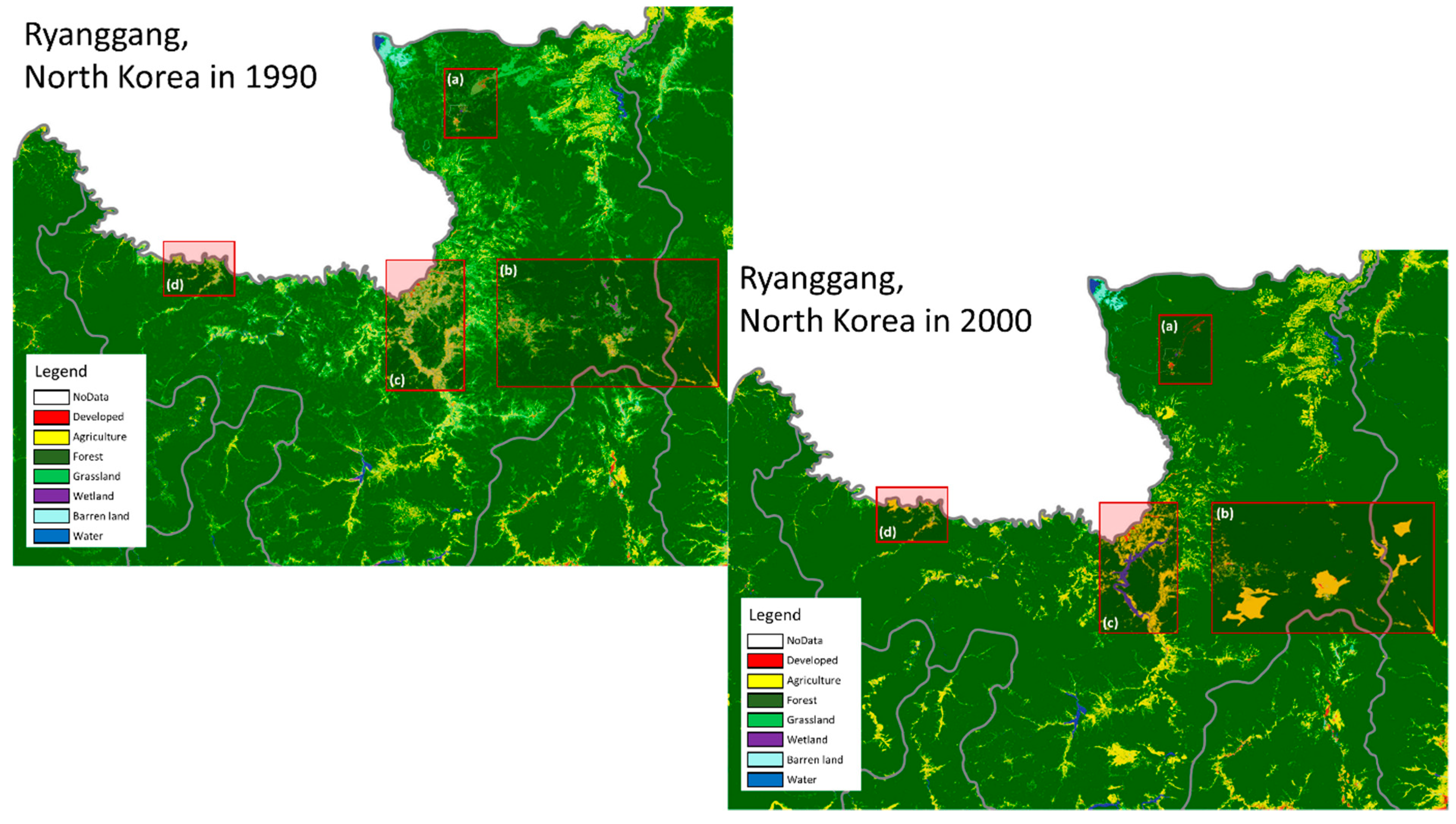
| LULC changes: urban areas with the development of water bodies | |||||||||||||||||
| LULC changes: in border regions than inland areas | |||||||||||||||||
| Presence of different types of houses (and allotments) | |||||||||||||||||
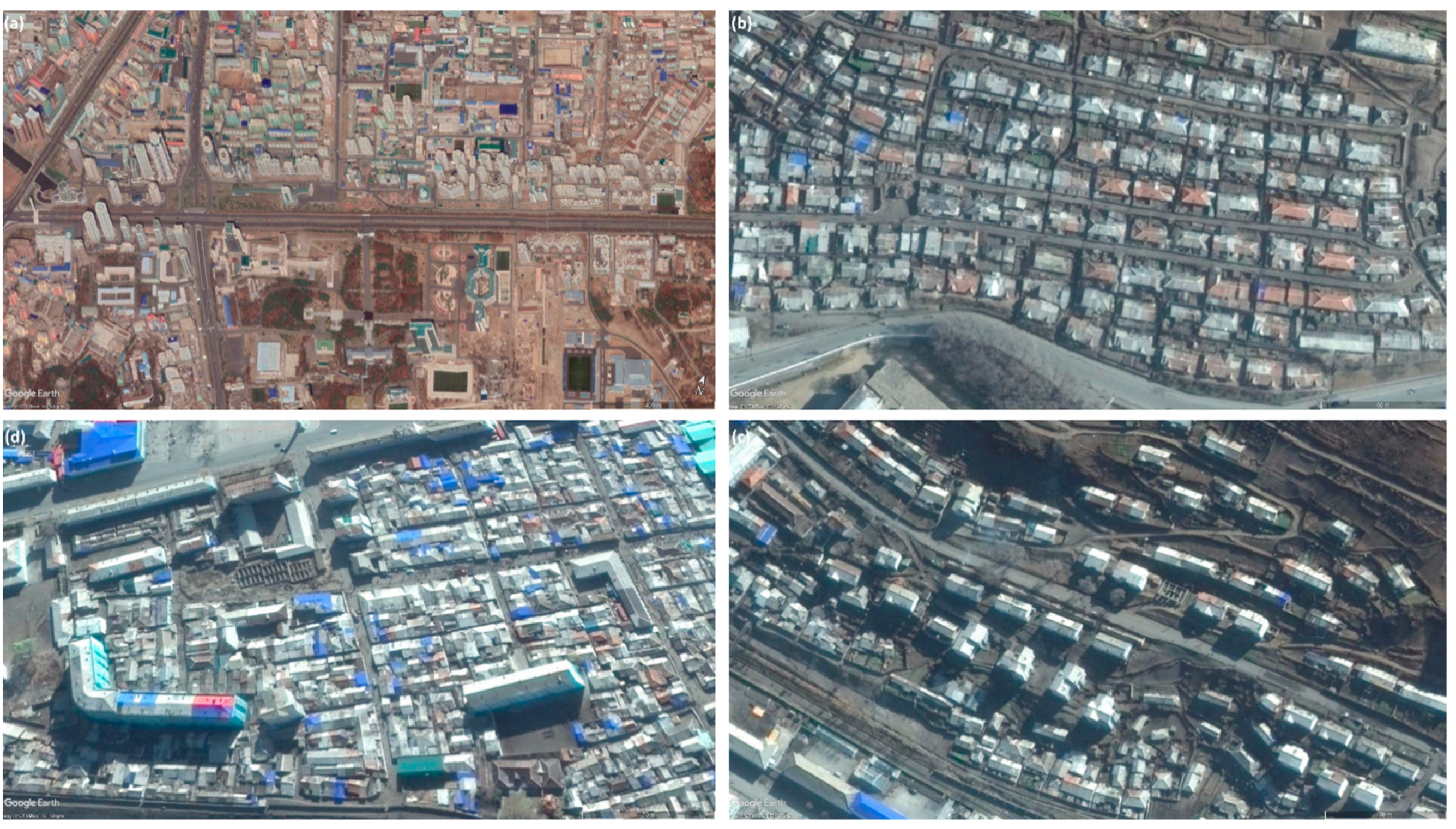
| (Semi-)detached houses: low building density, 1 or 2 storied houses, uniformly shaped settlement, in close proximity to roads, low to intermediate imperviousness | |||||||||||||||||
| Apartments: large rectangular simple form, regular alignment, more than three stories, and low to intermediate imperviousness and shadow silhouettes | |||||||||||||||||
| Allotments: detached small-sized buildings, low built-up land, low imperviousness, buffer between houses | |||||||||||||||||
| Harmonica houses (in rural areas): small roof with slate materials, chimneys on rooftops (small dot-shaped objects or a light shadow Silhouette) and fences (line-shaped objects) | |||||||||||||||||
| New construction or extension of residential building and expansion of construction activities | |||||||||||||||||
| 4.3 | Group LURs | Amalgamation of diverse community amenities | |||||||||||||||
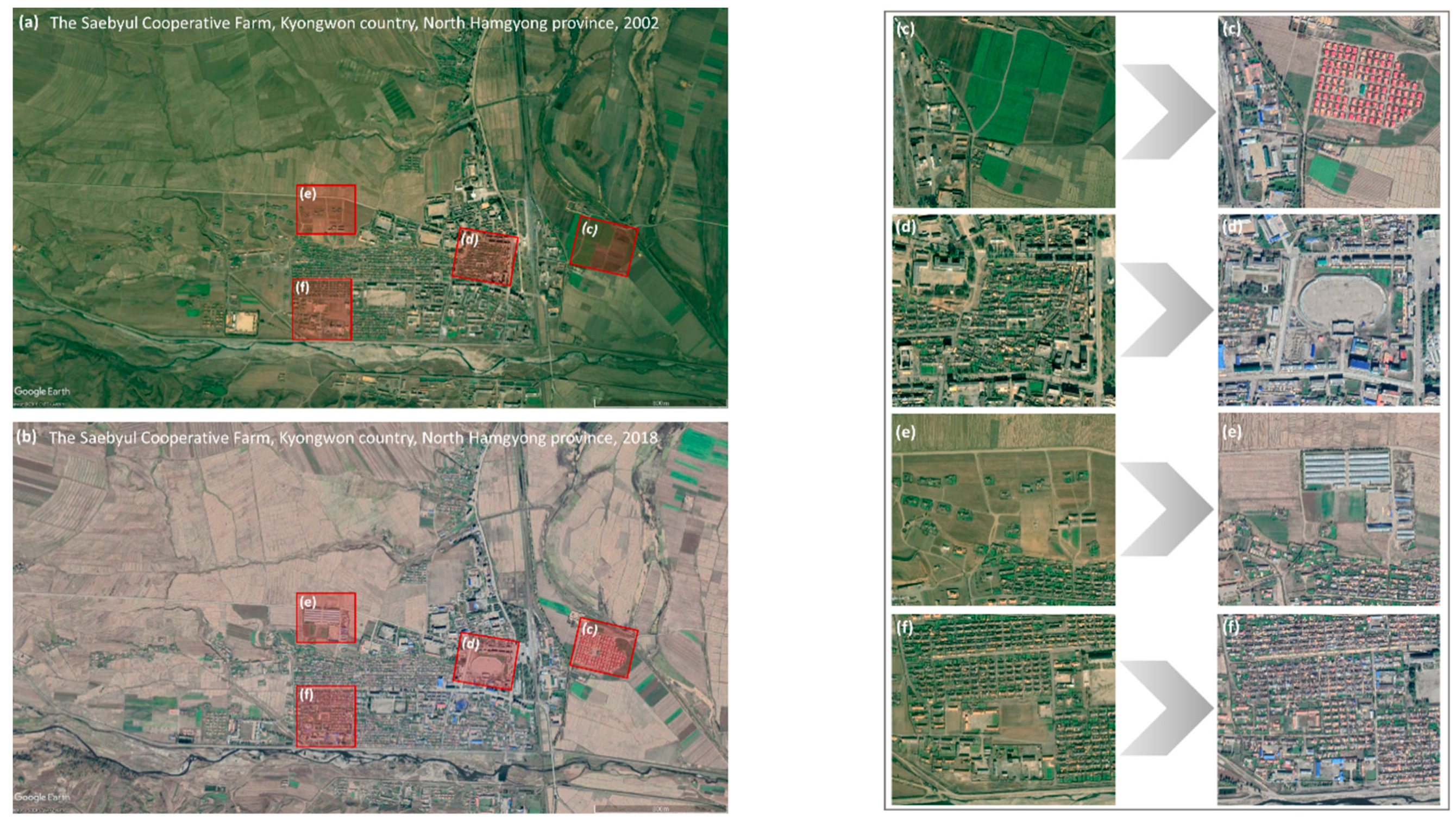
| Conversion: presence of multiple building objects with similar patterns, high density of settlement, simple rectangular forms, and same roof colors | |||||||||||||||||
| Adjacent land uses: similarity or dissimilarity | |||||||||||||||||
| Construction/extension of community buildings or infrastructure by the existing building removal | |||||||||||||||||
| Accessibility: improved access to roads (paved road and wider widths) | |||||||||||||||||
| Greenhouses: new construction in a barren land and adjacency to dwellings (materials: plastic or glass, roof colors: white or grey, brightness: light, and texture: rough) | |||||||||||||||||
| Increase of the number of houses in a certain vicinity (high density) | |||||||||||||||||
| Existence of undivided shared areas of the common property or public infrastructure | |||||||||||||||||
| 4.4 | LTRs | Presence of small land (sotoji): garden plot (GP), side-job plot (SJP), and tiny patch of land (TPL) | |||||||||||||||
| Garden plot (GP): small parcel size, in front/back yards or attached to each other, green color | |||||||||||||||||
| Side-job plot (SJP): large parcel size, in front/back yards or attached to each other, green color | |||||||||||||||||
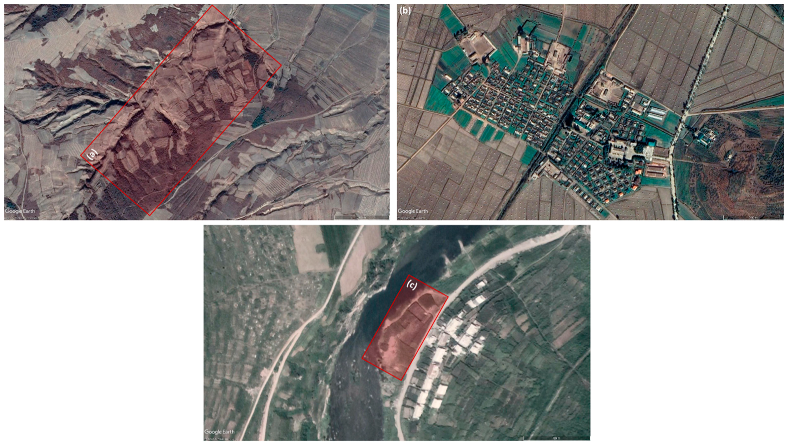
| Tiny patch of land (TPL): lower elevation, gentle slope less than 15%, the small patches of vegetation cover between neighboring lands on the mountain (hillsides) or along the streams or ditches | |||||||||||||||||
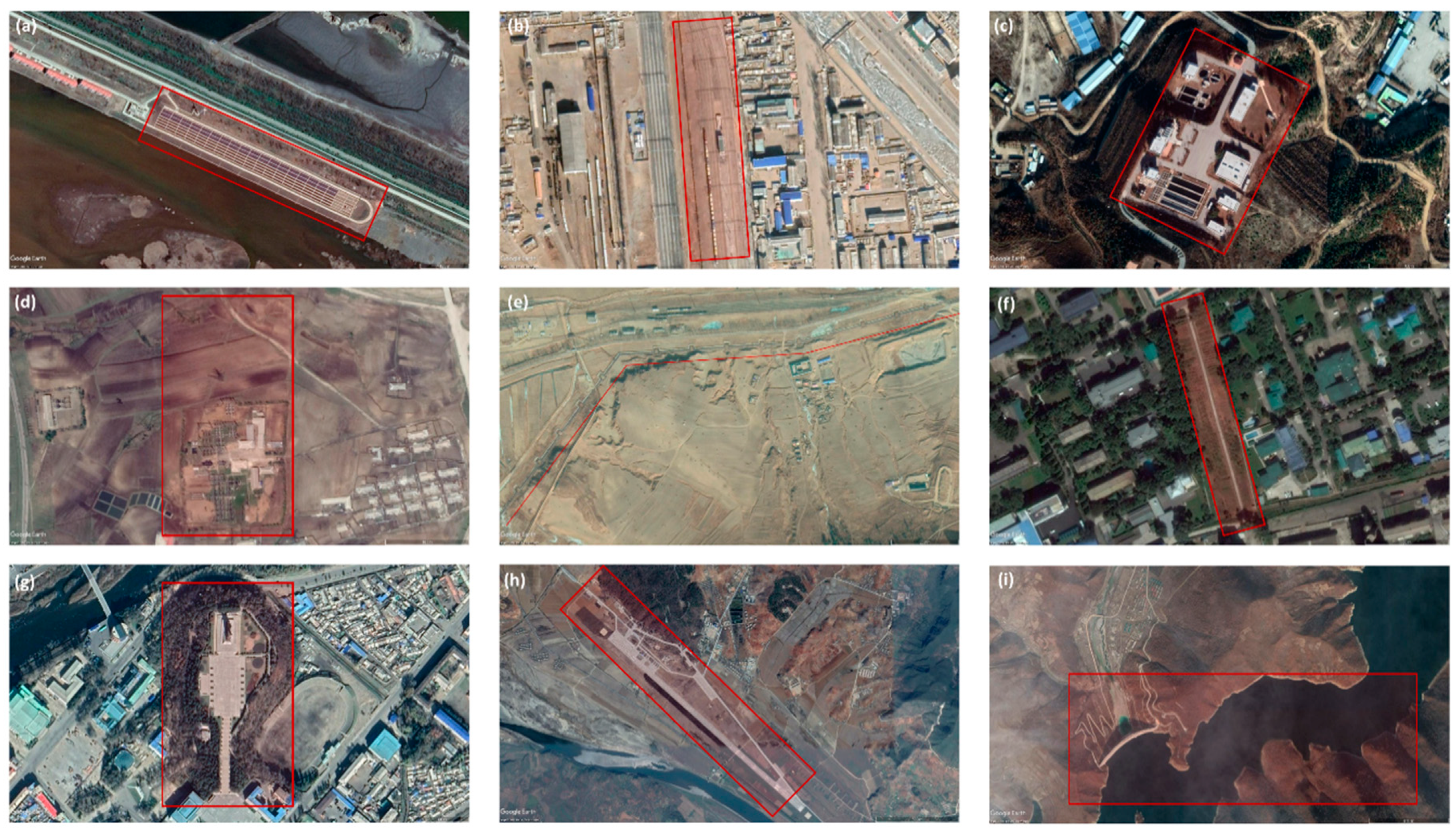
| 4.5 | LARs | Public utility networks, nature reserves, and heritage sites: in close proximity to hazardous or isolated locations, poor accessibility (lack of access roads; low to intermediate imperviousness), elongated object shapes, and less green and open spaces (fewer green colors and rough textures) | |||||||||||||||
| Subdivision of land parcels | |||||||||||||||||
| Note. | |||||||||||||||||
| Color | Shape | Size | Texture | Pattern | Shadow | Height | Site | Association | Density | ||||||||
© 2020 by the authors. Licensee MDPI, Basel, Switzerland. This article is an open access article distributed under the terms and conditions of the Creative Commons Attribution (CC BY) license (http://creativecommons.org/licenses/by/4.0/).
Share and Cite
Lee, C.; de Vries, W.T. Bridging the Semantic Gap between Land Tenure and EO Data: Conceptual and Methodological Underpinnings for a Geospatially Informed Analysis. Remote Sens. 2020, 12, 255. https://doi.org/10.3390/rs12020255
Lee C, de Vries WT. Bridging the Semantic Gap between Land Tenure and EO Data: Conceptual and Methodological Underpinnings for a Geospatially Informed Analysis. Remote Sensing. 2020; 12(2):255. https://doi.org/10.3390/rs12020255
Chicago/Turabian StyleLee, Cheonjae, and Walter Timo de Vries. 2020. "Bridging the Semantic Gap between Land Tenure and EO Data: Conceptual and Methodological Underpinnings for a Geospatially Informed Analysis" Remote Sensing 12, no. 2: 255. https://doi.org/10.3390/rs12020255
APA StyleLee, C., & de Vries, W. T. (2020). Bridging the Semantic Gap between Land Tenure and EO Data: Conceptual and Methodological Underpinnings for a Geospatially Informed Analysis. Remote Sensing, 12(2), 255. https://doi.org/10.3390/rs12020255


