Surface Temperature of the Planet Earth from Satellite Data
Abstract
1. Introduction
2. Materials and Methods
3. Results and Discussion
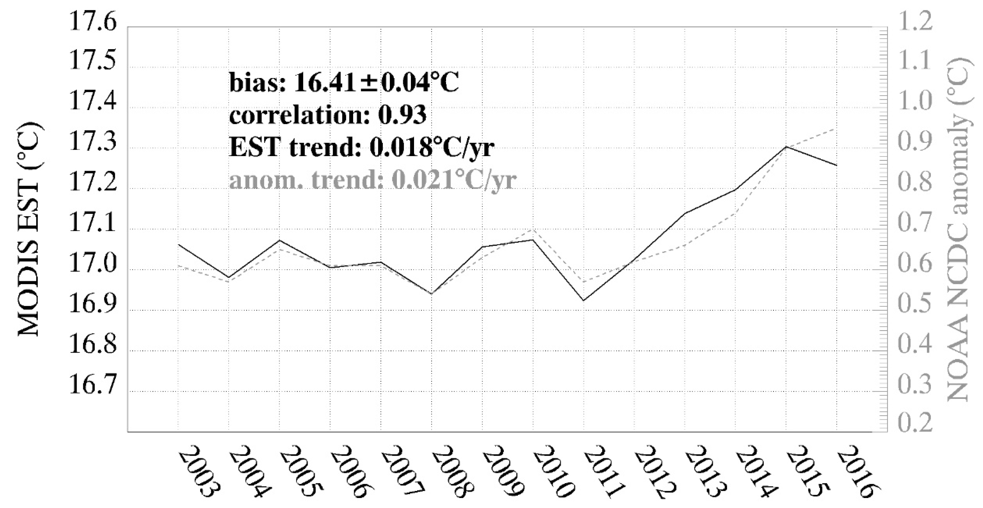
3.1. MODIS Earth Surface Temperature Matches NOAA NCDC Global Air Temperature Estimations
Air Temperature Versus Satellite Temperature
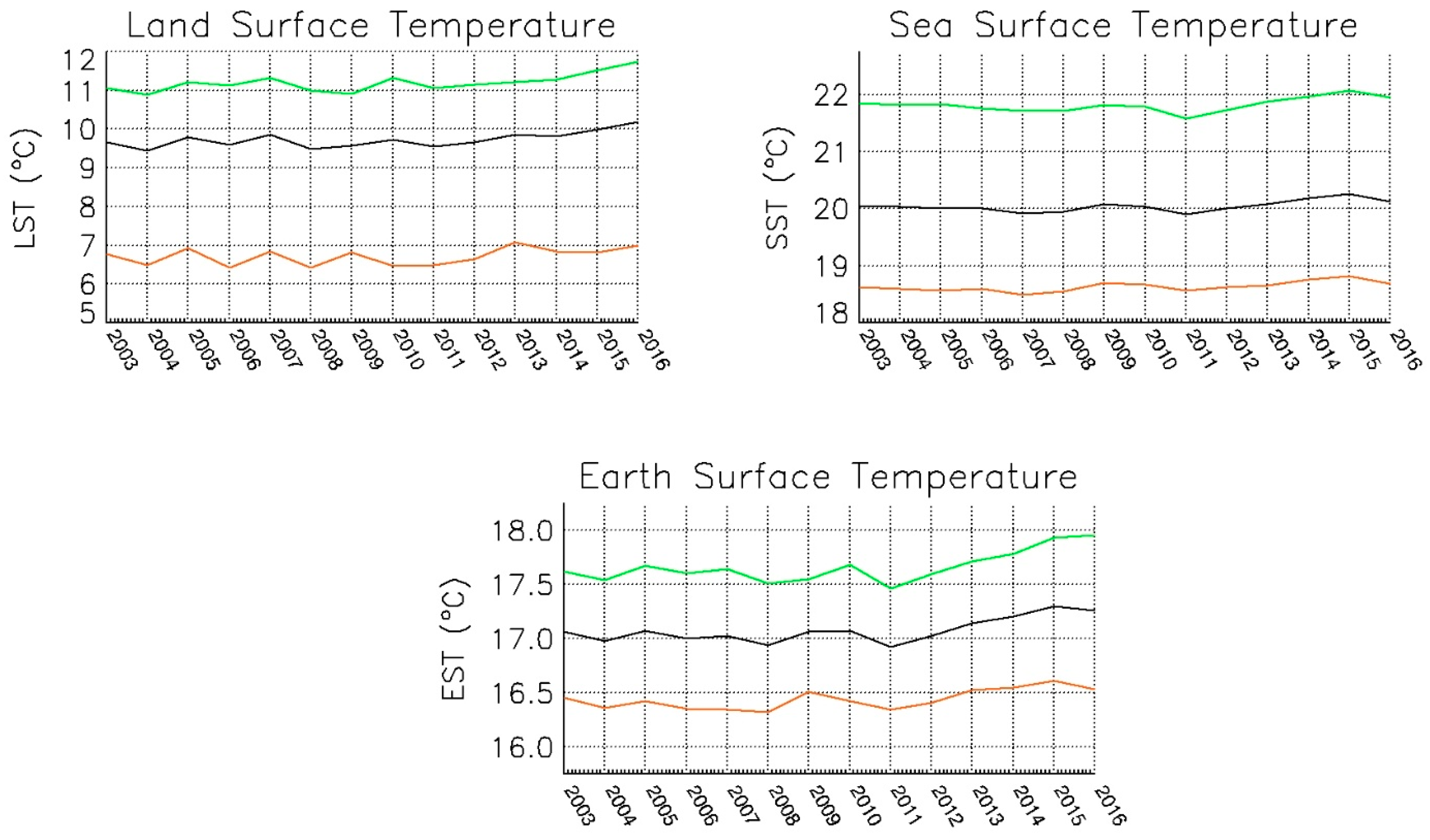
3.2. Regional Analysis: Northern Hemisphere Land Surface Contributes Most to Temperature Increases
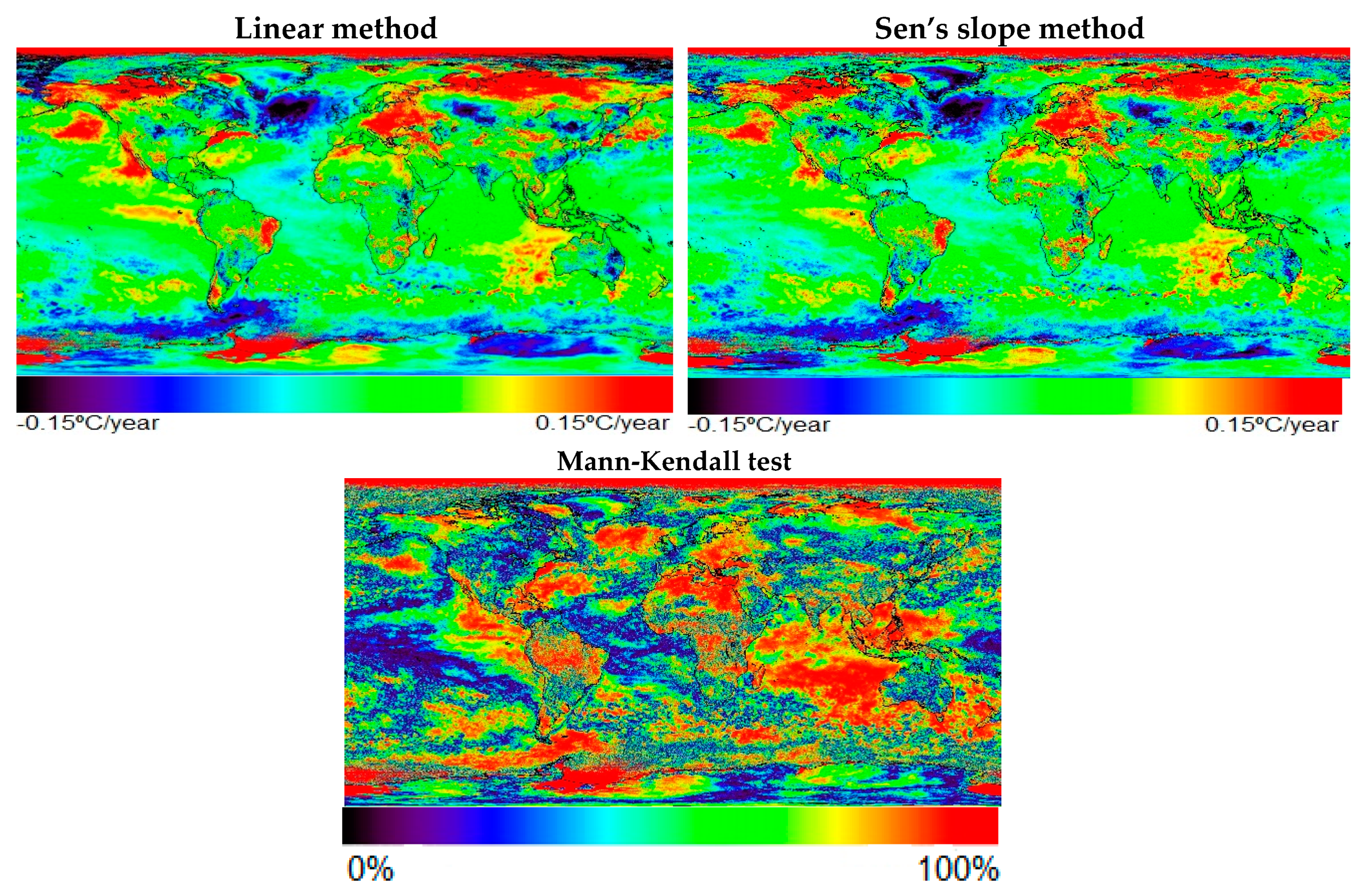
3.3. High Latitudes Show the Highest Land Surface Temperature Increases
3.4. Local Analysis: Northern Atlantic Ocean Is Cooling Fast, While SIBERIA and Boreal America Is Heating Faster
4. Conclusions
Author Contributions
Funding
Acknowledgments
Conflicts of Interest
References
- Field, C.B.; Barros, V.R.; Dokken, D.J.; Mach, K.J.; Mastrandrea, M.D.; Bilir, T.E.; Chatterjee, M.; Ebi, K.L.; Estrada, Y.O.; Genova, R.C.; et al. (Eds.) Climate Change 2014: Impacts, Adaptation, and Vulnerability. Part A: Global and Sectoral Aspects. Contribution of Working Group II to the Fifth Assessment Report of the Intergovernmental Panel on Climate Change; Cambridge University Press: Cambridge, UK; New York, NY, USA, 2014; p. 1132. [Google Scholar]
- CERSAT. Sea Surface Temperature In Situ Data. Available online: http://cersat.ifremer.fr/data/tools-and-services/match-up-databases/item/298-sea-surface-temperature-in-situ-data (accessed on 5 September 2019).
- Copernicus. In Situ Observations. Available online: https://insitu.copernicus.eu/observations (accessed on 5 September 2019).
- Mao, K.B.; Ma, Y.; Tan, X.L.; Shen, X.Y.; Liu, G.; Li, Z.L.; Chen, J.M.; Xia, L. Global surface temperature change analysis based on MODIS data in recent twelve years. Adv. Space Res. 2017, 59, 503–551. [Google Scholar] [CrossRef]
- NASA. Modis Specifications. Available online: https://modis.gsfc.nasa.gov/about/specifications.php (accessed on 4 June 2019).
- Wan, Z. New refinements and validation of the collection-6 MODIS land-surface temperature/emissivity product. Remote Sens. Environ. 2014, 140, 36–45. [Google Scholar] [CrossRef]
- NOAA National Centers for Environmental Information, State of the Climate: Global Climate Report for Annual 2018. Available online: https://www.ncdc.noaa.gov/sotc/global/201813 (accessed on 3 April 2019).
- Physical Oceanography Distributed Active Archive Center (PO.DAAC). Firefox ESR v38.4.0. Web Page. NASA EOSDIS PO.DAAC, Pasadena, CA. 2018. Available online: https://podaac.jpl.nasa.gov/ (accessed on 5 January 2019).
- Land Processes Distributed Active Archive Center (LP DAAC). NASA EOSDIC LP.DAAC, Sioux Falls, South Dakota. 2018. Available online: https://lpdaac.isgs.gov/ (accessed on 5 January 2019).
- Brown, B.; Minnett, P.J. MODIS Infrared Sea Surface Temperature Algorithm. Algorithm Theoretical Basis Document; Version 2.0; University of Miami: Miami, FL, USA, 1999. [Google Scholar]
- Wan, Z.; Zhang, Y.; Zhang, Q.; Li, Z.-L. Quality assessment and validation of the MODIS global land surface temperature. Int. J. Remote Sens. 2004, 25, 261–274. [Google Scholar] [CrossRef]
- Wan, Z. Collection-6. MODIS Land Surface Temperature Products Users’ Guide; ERI, University of California: Santa Barbara, CA, USA, 2013. [Google Scholar]
- Wan, Z. New refinements and validation of the MODIS Land-Surface Temperature/Emissivity products. Remote Sens. Environ. 2008, 112, 59–74. [Google Scholar] [CrossRef]
- Skokovic, D. Calibration and Validation of Thermal Infrared Remote Sensing Sensors and Land/Sea Surface Temperature algorithms over the Iberian Peninsula. Ph.D. Thesis, University of Valencia, Valencia, Spain, 2017; p. 98. [Google Scholar]
- Ghanea, M.; Moradi, M.; Kabiri, K.; Mehdinia, A. Investigation and validation of MODIS SST in the northern Persian Gulf. Adv. Space Res. 2016, 57, 127–136. [Google Scholar] [CrossRef]
- Vose, R.S.; Arndt, D.; Banzon, V.F.; Easterling, D.R.; Gleason, B.; Huang, B.; Kearns, E.; Lawrimore, J.H.; Menne, M.J.; Peterson, T.C. NOAA’s Merged Land-Ocean Surface Temperature Analysis. Bull. Am. Meteorol. Soc. 2012, 93, 1677–1685. [Google Scholar] [CrossRef]
- Merchant, C.J.; Embury, O.; Bulgin, C.E.; Block, T.; Corlett, G.K.; Fiedler, E.; Good, S.A.; Mittaz, J.; Rayner, N.A.; Berry, D.; et al. Satellite-based time-series of sea-surface temperature since 1981 for climate applications. Sci. Data 2019, 6, 223. [Google Scholar] [CrossRef] [PubMed]
- Jim, M.; Dickinson, R.E.; Vogelmann, A.M. A comnparison of CCM2-BATS Skin Temperature and Surface-Air Temperature with Satellite and Surface Observations. Am. Meteorol. Soc. 1997, 10, 1505–1524. [Google Scholar]
- Hooker, J.; Duveiller, G.; Cescatti, A. A global dataset of air temperature derived from satellite remote sensing and weather stations. Sci. Data 2018, 5, 180246. [Google Scholar] [CrossRef]
- Price, J.C. Using spatial context in satellite data to infer regional scale evapotranspiration. IEEE Trans. Geosci. Remote Sens. 28, 940–948. [CrossRef]
- Julien, Y.; Sobrino, J.A. Correcting Long Term Data Record V3 estimated LST from orbital drift effects. Remote Sens. Environ. 2012, 123, 207–219. [Google Scholar] [CrossRef]
- Sobrino, J.A.; Julien, Y.; Atitar, M.; Nerry, F. NOAA-AVHRR orbital drift correction from solar zenithal angle data. IEEE Trans. Geosci. Remote sens. 2008, 46, 4014–4019. [Google Scholar] [CrossRef]
- Vogt, J.V.; Viau, A.A.; Paquet, A.F. Mapping regional air temperature fields using satellite-derived surface skin temperatures. Int. J. Climatol. 1997, 17, 1559–1579. [Google Scholar] [CrossRef]
- Alfieri, S.M.; de Lorenzi, F.; Menenti, M. Mapping air temperature using time series analysis of LST: The SINTESI approach. Nonlinear Process. Geophys. 2013, 20, 513–527. [Google Scholar] [CrossRef]
- Jin, M.; Dickinson, R.E. A generalized algorithm for retrieving cloudy sky skin temperature from satellite thermal infrared radiances. J. Geophys. Res. 2000, 105, 27037–27047. [Google Scholar] [CrossRef]
- Mildrexler, D.J.; Zhao, M.; Running, S.W. A global comparison between station air temperatures and MODIS land surface temperatures reveals the cooling role of forests. J. Geophys. Res. 2011, 116. [Google Scholar] [CrossRef]
- Prihodko, L.; Goward, S.N. Estimation of air temperature from remotely sensed surface observations. Remote Sens. Environ. 1997, 60, 335–346. [Google Scholar] [CrossRef]
- Urban, M.; Eberle, J.; Hüttich, C.; Schmullius, C.; Herold, M. Comparison of satellite-derived land surface temperature and air temperature from meteorological stations on the pan-arctic scale. Remote Sens. 2013, 5, 2348–2367. [Google Scholar] [CrossRef]
- Jin, M.; Dickinson, R. Land surface skin temperature climatology: Benefitting from the strengths of satellite observations. Environ. Res. Lett. 2010, 5, 044004. [Google Scholar] [CrossRef]
- Benali, A.; Carvalho, A.C.; Nunes, J.P.; Carvalhais, N.; Santos, A. Estimating air surface temperature in Portugal using MODIS LST data. Remote Sens. Environ. 2012, 124, 108–121. [Google Scholar] [CrossRef]
- Hameed, S.N.; Jin, D.; Thilakan, V. A model for super El Niños. Nat. Commun. 2018, 9, 2528. [Google Scholar] [CrossRef] [PubMed]
- Klein, S.A.; Soden, B.J.; Lau, N. Remote Sea Surface Temperature Variations during ENSO: Evidence for a Tropical Atmospheric Bridge. J. Clim. 1999, 12, 917–932. [Google Scholar] [CrossRef]
- Yang, Y.; Xie, S.-P.; Wu, L.; Yu, K.; Li, J. ENSO forced and local variability of North Tropical Atlantic SST: Model simulations and biases. Clim. Dyn. 2018, 51, 4511–4524. [Google Scholar] [CrossRef]
- Von Schuckmann, K.; Le Traon, P.Y.; Alvarez-Fanjul, E.; Axell, L.; Balmaseda, M.; Breivik, L.A.; Brewin, R.J.; Bricaud, C.; Drevillon, M.; Drillet, Y.; et al. The Copernicus Marine Environment Monitoring Service Ocean State Report. J. Oper. Oceanogr. 2016, 9, 235–320. [Google Scholar] [CrossRef]
- Hausfather, Z.; Cowtan, K.; Clarke, D.C.; Jacobs, P.; Richardson, M.; Rohde, R. Assessing recent warming using instrumentally homogenous sea surface temperature records. Sci. Adv. 2017, 3, e1601207. [Google Scholar] [CrossRef]
- Lawrence, S.P.; Llewelyn-Jones, D.T.; Smith, S.J. The measurement of climate change using data from the Advanced Very High Resolution and Along Track Scanning Radiometers. J. Geophys. Res. 2004, 109, C08017. [Google Scholar] [CrossRef]
- Von Schuckmann, K.; Le Traon, P.Y.; Smith, N.; Pascual, A.; Djavidnia, S.; Gattuso, J.P.; Grégoire, M.; Nolan, G.; Aaboe, S.; Aguiar, E.; et al. Copernicus Marine Service Ocean State Report, Issue 3. J. Oper. Oceanogr. 2019, 12, 1–23. [Google Scholar] [CrossRef]
- Retamales-Muñoz, G.; Durán-Alarcón, C.; Mattar, C. Recent land Surface temperature patterns in Antarctica using satellite and reanalysis data. J. S. Am. Earth Sci. 2019, 95, 102304. [Google Scholar] [CrossRef]


| Latitudinal Zone | LST (°C/yr.) | SST (°C/yr.) | EST (°C/yr.) |
|---|---|---|---|
| 90°–66.5° NH | 0.080 | 0.0026 | 0.032 |
| 66.5°–23.5° NH | 0.036 | 0.018 | 0.028 |
| 23.5°– 0 NH | 0.023 | 0.021 | 0.021 |
| 0–23.5° SH | 0.035 | 0.022 | 0.025 |
| 23.5°–66.5° SH | 0.012 | 0.010 | 0.011 |
| 66.5°–90° SH | 0.064 | −0.013 | 0.031 |
| NH | 0.036 | 0.013 | 0.022 |
| SH | 0.019 | 0.013 | 0.014 |
| Global | 0.030 | 0.013 | 0.018 |
© 2020 by the authors. Licensee MDPI, Basel, Switzerland. This article is an open access article distributed under the terms and conditions of the Creative Commons Attribution (CC BY) license (http://creativecommons.org/licenses/by/4.0/).
Share and Cite
Sobrino, J.A.; Julien, Y.; García-Monteiro, S. Surface Temperature of the Planet Earth from Satellite Data. Remote Sens. 2020, 12, 218. https://doi.org/10.3390/rs12020218
Sobrino JA, Julien Y, García-Monteiro S. Surface Temperature of the Planet Earth from Satellite Data. Remote Sensing. 2020; 12(2):218. https://doi.org/10.3390/rs12020218
Chicago/Turabian StyleSobrino, José Antonio, Yves Julien, and Susana García-Monteiro. 2020. "Surface Temperature of the Planet Earth from Satellite Data" Remote Sensing 12, no. 2: 218. https://doi.org/10.3390/rs12020218
APA StyleSobrino, J. A., Julien, Y., & García-Monteiro, S. (2020). Surface Temperature of the Planet Earth from Satellite Data. Remote Sensing, 12(2), 218. https://doi.org/10.3390/rs12020218


