Editorial

Remote Sensing Open Access Journal of MDPI: Current Progress and Future Vision

by
Prasad S. Thenkabail
1,2
1
Western Geographic Science Center (WGSC), United States Geological Survey, 2255 N Gemini Drive, Suite 316, Flagstaff, AZ 86001, USA
2
Editor-in-Chief, Remote Sensing Open Access Journal of MDPI
Remote Sens. 2020, 12(15), 2442; https://doi.org/10.3390/rs12152442
Submission received: 21 July 2020 / Accepted: 22 July 2020 / Published: 30 July 2020

1. Performance Parameters of Various Remote Sensing International Journals

A comparison of various remote sensing, geoscience, and Geographic Information Systems (GIS) international journals is provided in Table 1. There are five critical parameters to weigh the performance of the journals. These are (Table 1):
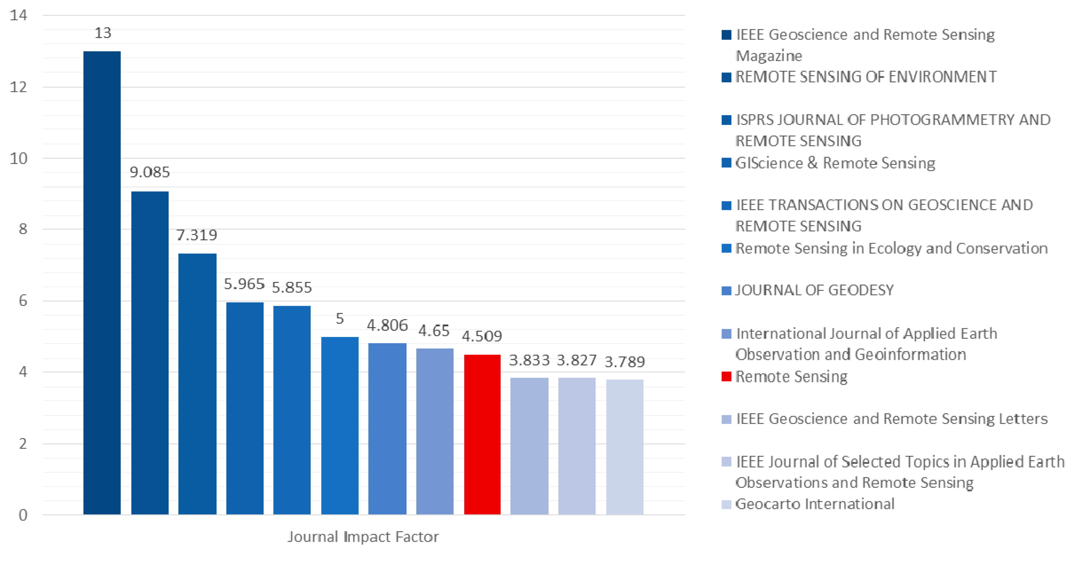
  • Journal Impact Factor (JIF);
  • Eigen Factor Score;
  • Normalized Eigen Factor Score;
  • Article Influence Score; and
  • Total Cites.
The performance parameters for the year 2019 are listed in Table 1. The journal ranked #1 for each parameter is highlighted in green (see each column in Table 1). Remote Sensing of Environment (RSE) and the ISPRS Journal of Photogrammetry and Remote Sensing continue to lead the pack with impressive Journal Impact Factor (JIF) scores of 9.085 and 7.319, respectively. The IEEE Geoscience and Remote Sensing Magazine (JRSM) has an outstanding JIF of 13, the highest amongst the pack. However, relative to whopping 62,697 citations of RSE, JRSM has just 1304 citations or 2.8% of RSE (Table 1). It demonstrates flaws in comparing a journal publishing a very large number of papers to a journal publishing very few selective papers that are cited many times. The same flaw exists across several journals. For example, Remote Sensing in Ecology and Conservation has a JIF of 5 but has a meagre 440 citations (0.7% of RSE!). This is exactly why looking at a single factor like JIF is misleading. Remote Sensing Open Access Journal (OAJ) of MDPI, which has a JIF of 4.509, has a total number of citations of 36,083.
Remote Sensing OAJ of MDPI ranks #1 amongst all remote sensing journals when Eigenfactor scores (0.06661) and normalized Eigenfactor scores (8.1265) are considered. Eigenfactors are considered a “prestige” measure. It measures [1,2,3,4]:
  • The number of times an article published in the journal in past 5 years (2014–2018) is cited in Journal Citation Reports© (JCR) (2019);
  • Citations by taking into consideration which journals cite it. Highly cited journals are given higher weightage and less cited journals are given lesser weightage; and
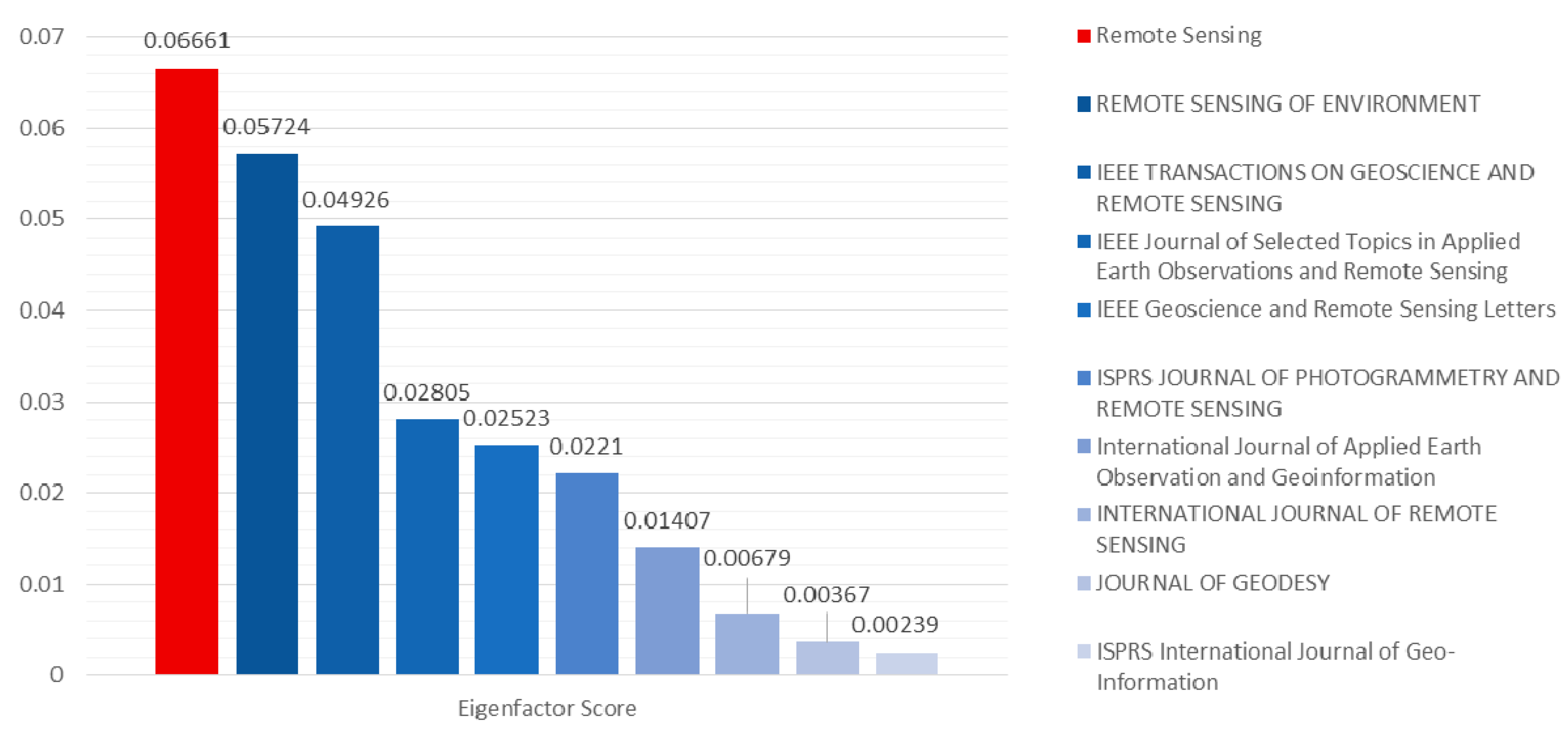
  • Citations by discounting references from one article in a journal to another article from the same journal. So, the journal self-citation is excluded from the Eigenfactor.
For the normalized Eigenfactor score, an average journal has a value of 1. A normalized Eigenfactor score of 8.1265 for Remote Sensing OAJ means that the journal is 8.1265 times as influential as the average journal in the JRC year (2019). The two next best performing journals after Remote Sensing in Eigenfactor and normalized Eigenfactor measures are Remote Sensing of Environment (0.05724, 6.984) and IEE Transactions of Geoscience and Remote Sensing (0.04926, 6.0106).
The Eigenfactor score and the normalized Eigenfactor score increase with the number of articles published in a year.
The article influence score measures the average influence per article of the papers published in the journal over the first five years after publication [1]. The difference is that the Eigenfactor score measures the total influence of a journal, and the Article Influence Score takes into account the size of the journal [1]. The IEEE Geoscience and Remote Sensing Magazine has the highest article influence score of 2.996 of all remote sensing journals. Many journals publish very few articles, but each article has a higher article influence score. For example, in 2019, IEEE Geoscience and Remote Sensing Magazine had a total citation number of 1304, which is just 2.07% of the citations of Remote Sensing of Environment (62,697 citations), 2.8% of the citations of IEEE Transactions of Geoscience and Remote Sensing (46,565 citations), and 3.61% of the citations of Remote Sensing OAJ of MDPI (36,083 citations). So, when a journal is extremely selective and publishes only very high impact articles, many parameters like the Journal Impact Factor and Article Influence Score go up swiftly.
In terms of total citations (Table 1) during 2019, the three leading journals were Remote Sensing of Environment (62,697), IEEE Transactions on Geoscience and Remote Sensing (46,565), and Remote Sensing (36,083). In this regard, Remote Sensing OAJ of MDPI increased its citations by 12,516 in 2019 (36,083) compared to 2018 (23,567). This is the highest increase in the number of citations in a single year by any journal (Table 1).

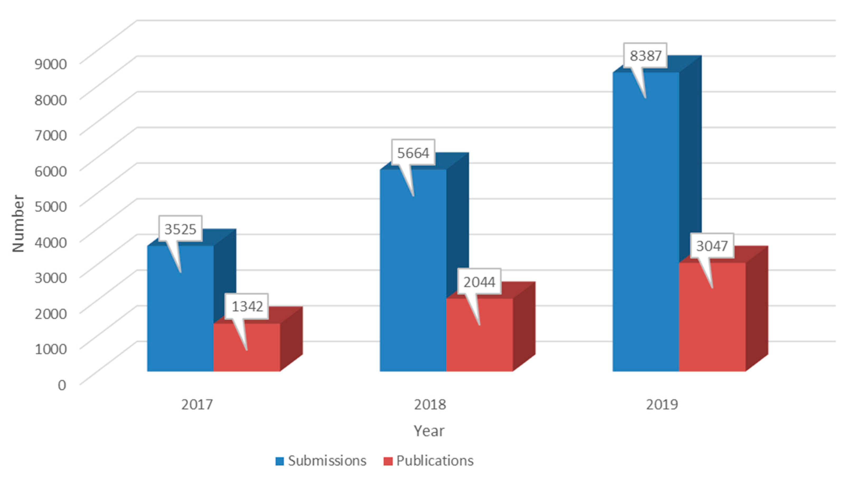
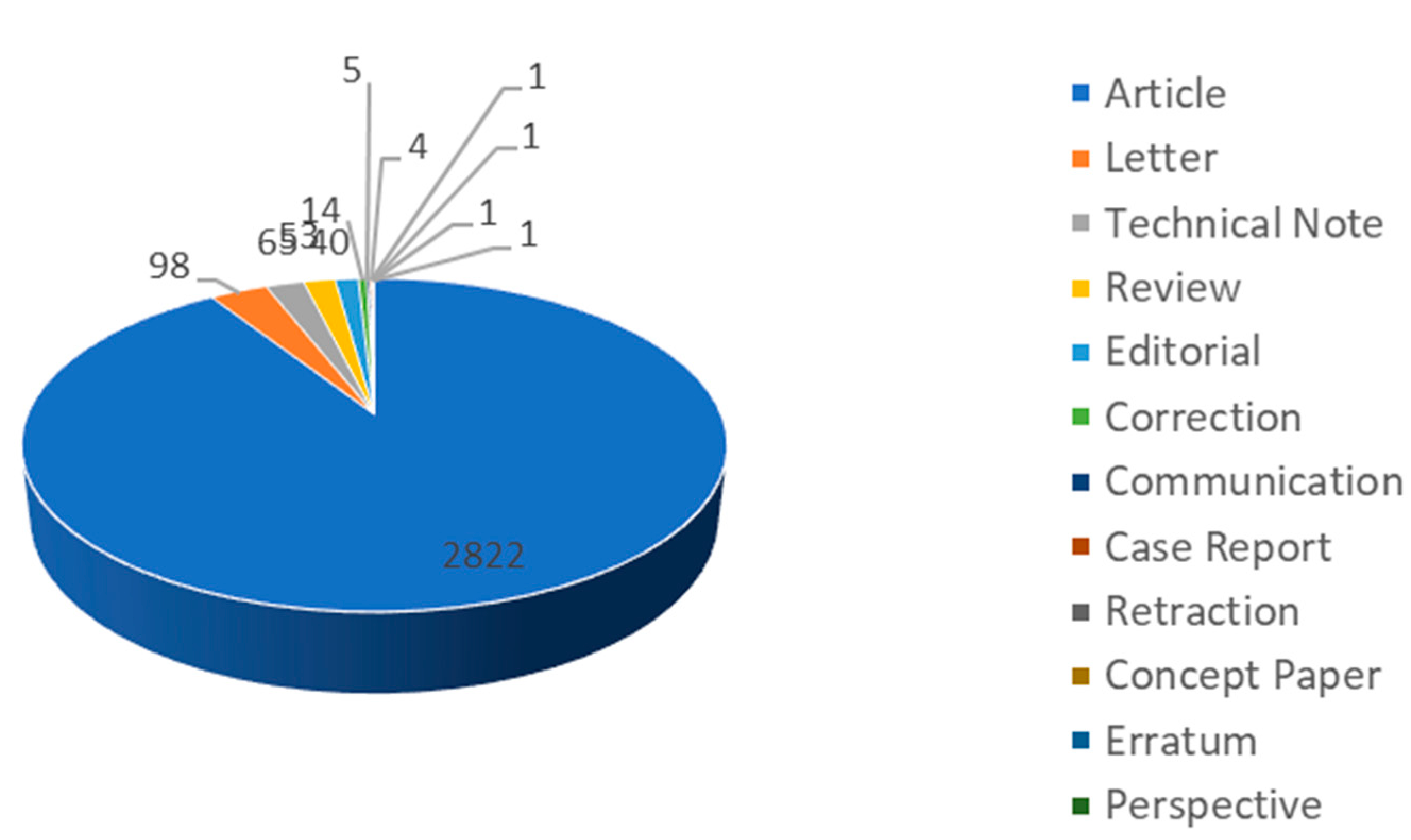
2. Remote Sensing Open Access Journal Publications

In 2019, 8381 manuscripts were submitted to Remote Sensing Open Access Journal of MDPI and 3047 (36.35%) of them were published (Figure 1) after a rigorous peer-review process. Compared with 2018, the number of submissions and publications in 2019 increased by 48.08% and 49.07%, respectively. Among the publications in 2019, there were 2822 (90.89%) articles, 98 (3.16%) letters, 65 (2.09%) technical notes, and 53 (1.707%) reviews (Figure 2). The monthly publication number increased from 214 in January to 313 in December (Figure 3).
Authors originated from 118 countries/regions. Figure 4 shows the top 10 countries/territories based on the percentage of author distribution, including China, the USA, Germany, Italy, the UK, Spain, France, Canada, Australia, and the Netherlands. China is at the top of the list, at about 45.32%, followed by the USA at 23.53%.

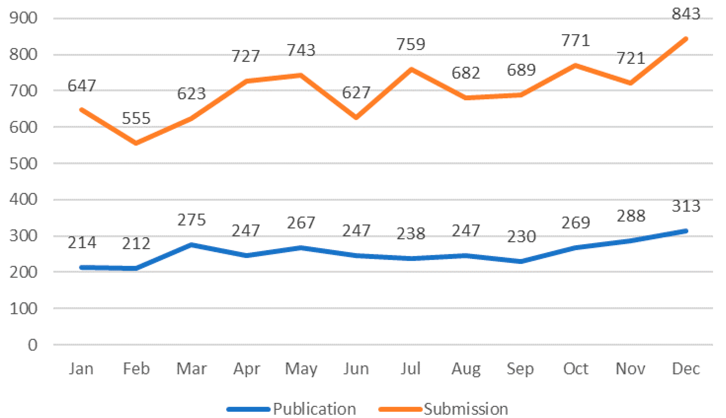
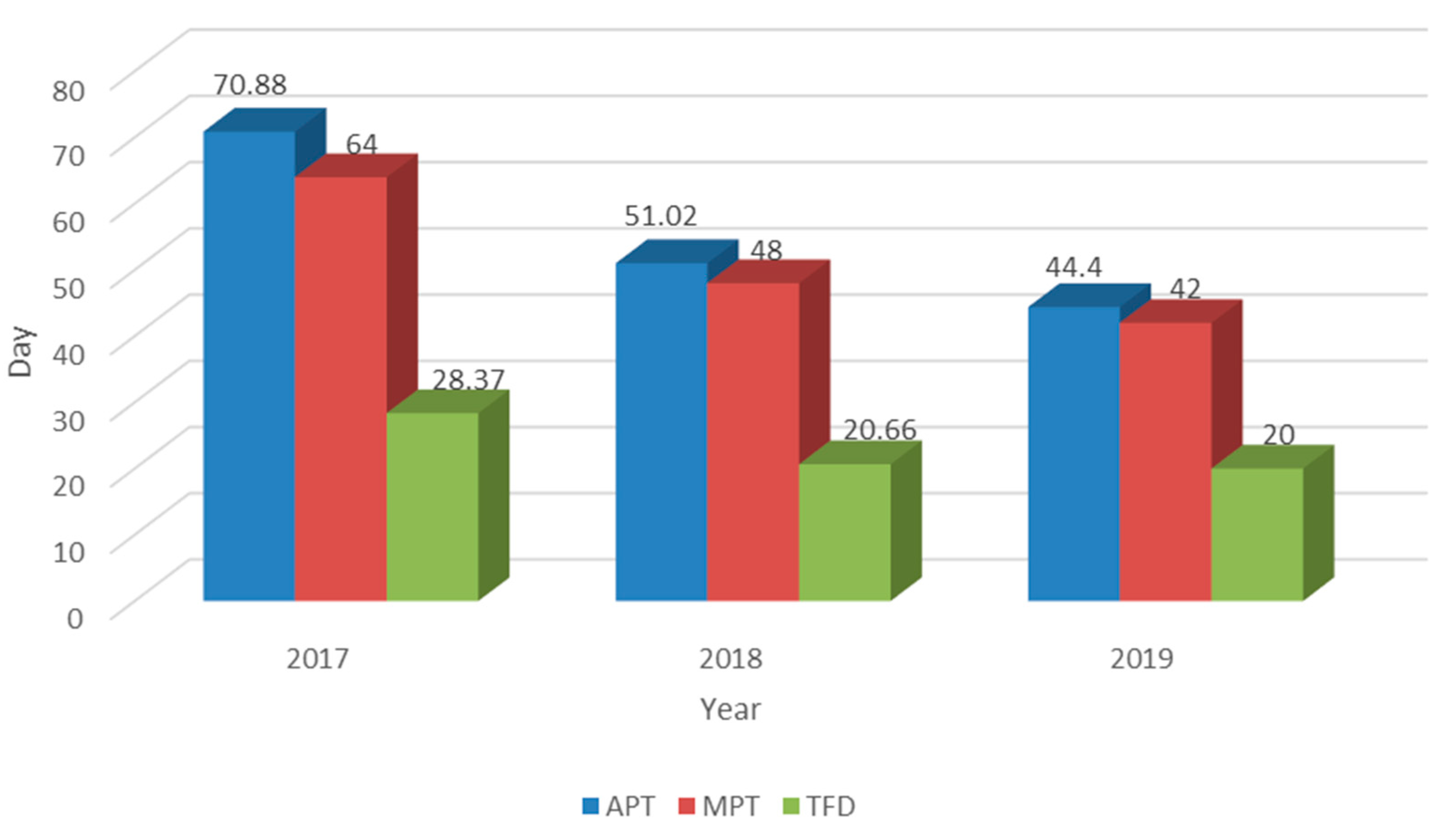
2.1. Publication Time

As shown in Figure 5, the average publication time (APT, 44.4 days), median publication time (MPT, 42 days), and time from submission to first decision (TFD, 20 days) in 2019 were much shorter, so that innovative studies were published without delay, which helped with the dissemination of research.

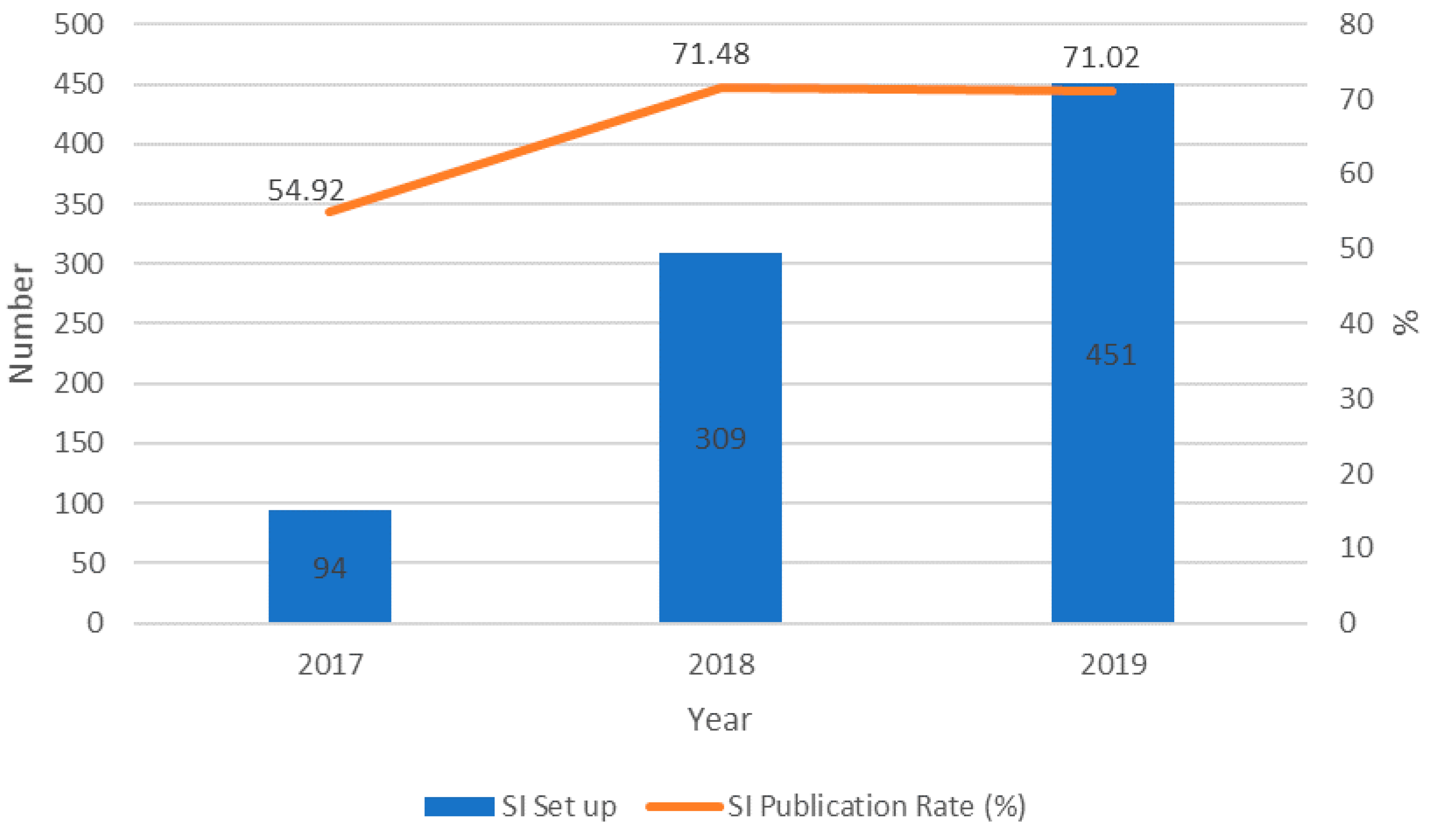
2.2. Special Issue (SI)

In 2019, 451 SIs were set up, an increase of 45.95% compared with 2018 (Figure 6). Moreover, Figure 6 shows that the publication rate for SIs in 2019 was 71.02%, keeping a similar rate as 2018, as SIs were still the main sources of publications. All SIs can be accessed at https://www.mdpi.com/journal/remotesensing/special_issues. Inviting top researchers to edit Special Issues has been very productive and has attracted a large number of researchers looking to publish their research in a top-quality journal expeditiously.
The best five SIs that closed in 2019 are listed in Table 2:

3. Editorial Board

In 2019, five new sections were set up and five new Section Editors-in-Chief (SEiCs) joined us, including Dr. Magaly Koch for the Section “Environmental Remote Sensing”, Prof. Stuart Phinn for “Coral Reef Remote Sensing”, Prof. Mattia Crespi for “Engineering Remote Sensing”, Dr. Vincenzo Levizzani for “Remote Sensing of the Water Cycle”, and Dr. Deepak R. Mishra for “Remote Sensing Letter”. Moreover, Prof. Gerrit de Leeuw and Dr. Jorge Vazquez took over from Dr. Richard Müller and Dr. Xiaofeng Li as new SEiCs for “Atmosphere Remote Sensing” and “Ocean Remote Sensing”, respectively.
In addition, 27 new Associate Editors were promoted and the number of Editorial Board Members increased from 280 to 605 in 2019 (Table 3). We also created two new positions in 2019, Topic Editor and Reviewer Board Member. The 17 Topic Editors were on board to help propose and manage new Special Issues, and also to promote our journal at various conferences. Furthermore, 1107 Reviewer Board Members joined our team to help provide high-quality reviews.
All Editorial Board Members, Reviewer Board Members, and Topic Editor information can be accessed at the following links, respectively:

4. Competition Analysis

Among all the 30 journals under the category “Remote Sensing” (https://jcr.incites.thomsonreuters.com), the Impact Factor of Remote Sensing OAJ of MDPI (4.509) ranks 9th, Q2 (Figure 7). Compared to the top five journals, the main competitive advantages of Remote Sensing OAJ of MDPI are shorter publication time, a lower article processing charge, and rich experience in the open-access field.
Among all of the journals under this category, the Eigenfactor score and normalized Eigenfactor of Remote Sensing OAJ of MDPI (0.06661, 8.1265) ranks 1st (Figure 8 and Figure 9). We have been emphasizing both the quality of the published articles and the impact in the field since 2018.
Among all of the journals under this category, the Article Influence Score of Remote Sensing OAJ of MDPI (0.927) ranks 9th (Figure 10).

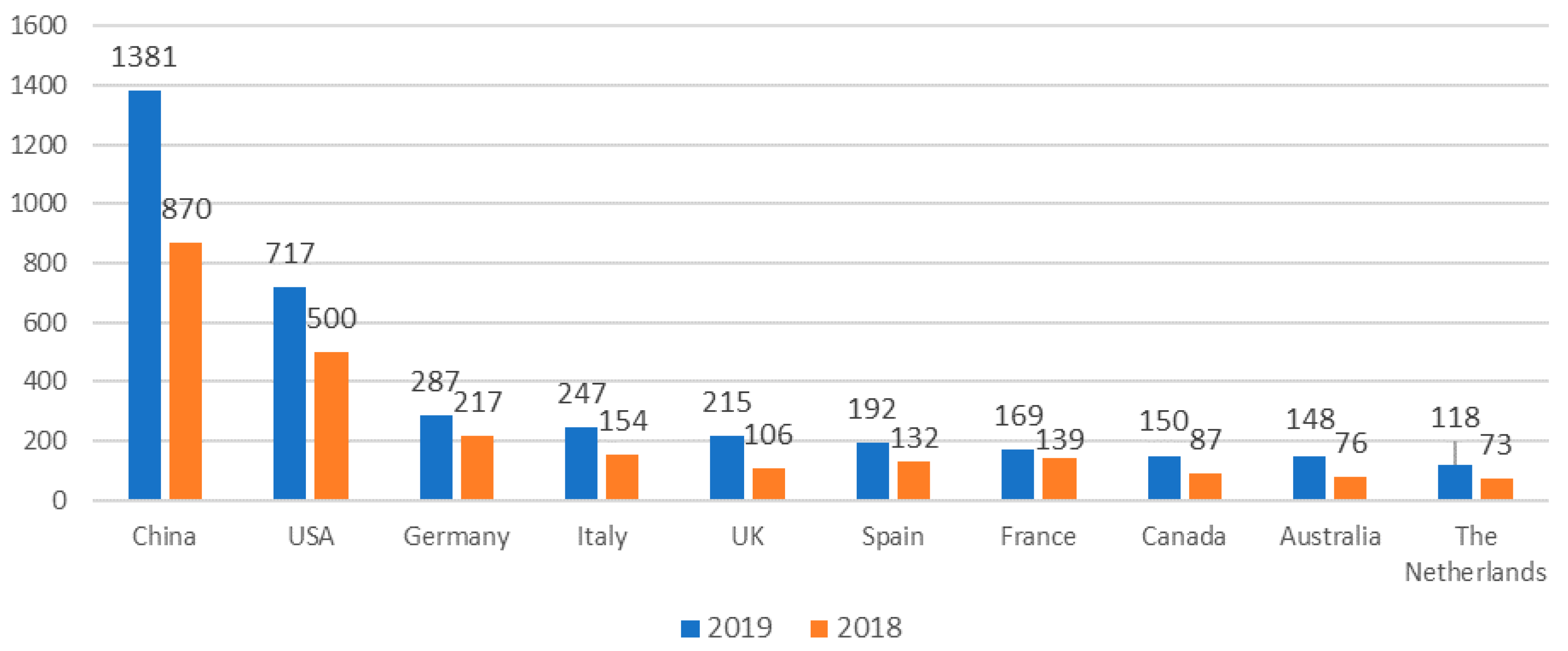
5. A Bibliographic analysis of Remote Sensing Open Access Journal of MDPI

A detailed bibliometric profile of the Remote Sensing Open Access Journal Published by MDPI between 2009 and 2018 is provided by Drs. Zhang, Thenkabail and Wang [5].

6. Current Achievements and the Way Forward

Remote Sensing Open Access Journal (OAJ) of MDPI was the first open access journal in remote sensing that began publishing in the year 2009. It published about 100 articles per year then, but now publishes above 3000 articles per year, the highest by any remote sensing international journal. It is now a well-recognized and respected international journal of repute in remote sensing, where the very best scientists in the subject from around the world publish regularly. In 2019, 8381 articles were submitted, but only 36% of them were published, which indicates a very high interest in publishing in the journal, but at the same time, there is a critical review process where a large number (64%) of the articles were rejected either at submission or during the peer-review process. Maintaining an impact factor of 4.509 with such a high number of publications is itself a testament to the quality of the articles published. Remote Sensing Open Access Journal of MDPI can easily further increase its impact factor swiftly, if 20–30% of the lesser ranked articles are not published. However, this creates a problem where very good articles are rejected solely based on novelty or unfounded, and often biased, subjective criticism of the value of the article. The journal follows a rigorous peer-review process involving two or more reviewers (most often three or more reviewers) followed by single or multi-tiered editorial scrutiny. Typically, multiple rounds of reviews and editorial scrutiny are involved.
Remote Sensing OAJ of MDPI is now a well-recognized leading open access journal that allows free downloads of the articles from anywhere in the world with simple internet access. Its review is fast with a median of 45 days from submission to publishing. It has rich set of articles, as evidenced by the journal performance parameters in Table 1. These articles are written by some of the best researchers on the subject from around the world. In 2019, articles originated from 118 countries. Nearly 70% for these articles came from China and the USA, followed by European countries (Germany, Italy, the UK, Spain, France, the Netherlands), Canada, and Australia. Remote Sensing OAJ provides readers and authors statistics on each article, such as the number of downloads and number of citations. Remote Sensing OAJ ranks #1 amongst all remote sensing journals in terms of Eigenfactor scores (0.06661) and normalized Eigenfactor scores (8.1265). It increased its citations by 12,516 in 2019 (36,083) compared to 2018 (23,567), the highest increase in the year by any Remote Sensing Journal. Remote Sensing of Environment with 62,697 citations, and IEEE Transactions on Geoscience and Remote Sensing with 46,565 citations rank above Remote Sensing OAJ in 2019.
There is a clear “paradigm-shift” in how remote sensing science is conducted in the last few years with swift advances in big-data analytics, machine learning, deep learning, artificial intelligence, cloud computing, and Application Programming Interfaces (APIs). Analysis Ready Data (ARD) and reference training and validation data Hubs in support of creating knowledge-base to train machine\deep learning algorithms and validation of the products further help in speed and accuracy of production of myriad remotely sensed data derived science applications. A whole new world of smallsats and CubeSats are revolutionizing how remote sensing data is acquired, processed, and made available to users. As a result of all these endeavors, remote sensing data user base and its applications are expanding exponentially and has led to quantum leap in productivity and speed of research. Combination of these factors are expected to further increase remote sensing data derived science publications and applications in the coming years.
Going forward, our goal remains to publish cutting-edge impactful research of importance and value to scientists and the public, research that enhances our knowledge or fills a missing gap in knowledge, and applied science of practical value in remote sensing and related sciences.

Funding

This research received no external funding.

Acknowledgments

The EiC would like to express thanks to Denise Liu, Managing Editor of Remote Sensing, as well as the Editorial Team who contributed by providing inputs to this article. Any use of trade, firm, or product names is for descriptive purposes only and does not imply endorsement by the U.S. Government.

Conflicts of Interest

The author declares no conflict of interest.

References

  1. Clarivate Analytics. The Clarivate Analytics Impact Factor. 2020. Available online: https://clarivate.com/webofsciencegroup/essays/impact-factor/ (accessed on 13 July 2020).
  2. West, J.D.; Jensen, M.C.; Dandrea, R.J.; Gordon, G.J.; Bergstrom, C.T. Author-Level Eigenfactor Metrics: Evaluating the Influence of Authors Institutions and Countries within the SSRN Community. J. Am. Soc. Inf. Sci. Tec. 2013, 64, 787–801. [Google Scholar] [CrossRef]
  3. West, J.D.; Bergstrom, T.C.; Bergstrom, C.T. The Eigenfactor™ Metrics: A network approach to assessing scholarly journals. Coll. Res. Lib. 2010, 71, 236–244. [Google Scholar] [CrossRef] [Green Version]
  4. West, J.D.; Bergstrom, T.C.; Bergstrom, C.T. Big Macs and Eigenfactor Scores: Don’t Let Correlation Coefficients Fool You. J. Am. Soc. Inf. Sci. Tec 2010, 61, 1800–1807. [Google Scholar] [CrossRef] [Green Version]
  5. Zhang, Y.; Thenkabail, P.S.; Wang, P. A Bibliometric Profile of the Remote Sensing Open Access Journal Published by MDPI between 2009 and 2018. Remote Sens. 2019, 11, 91. [Google Scholar] [CrossRef]
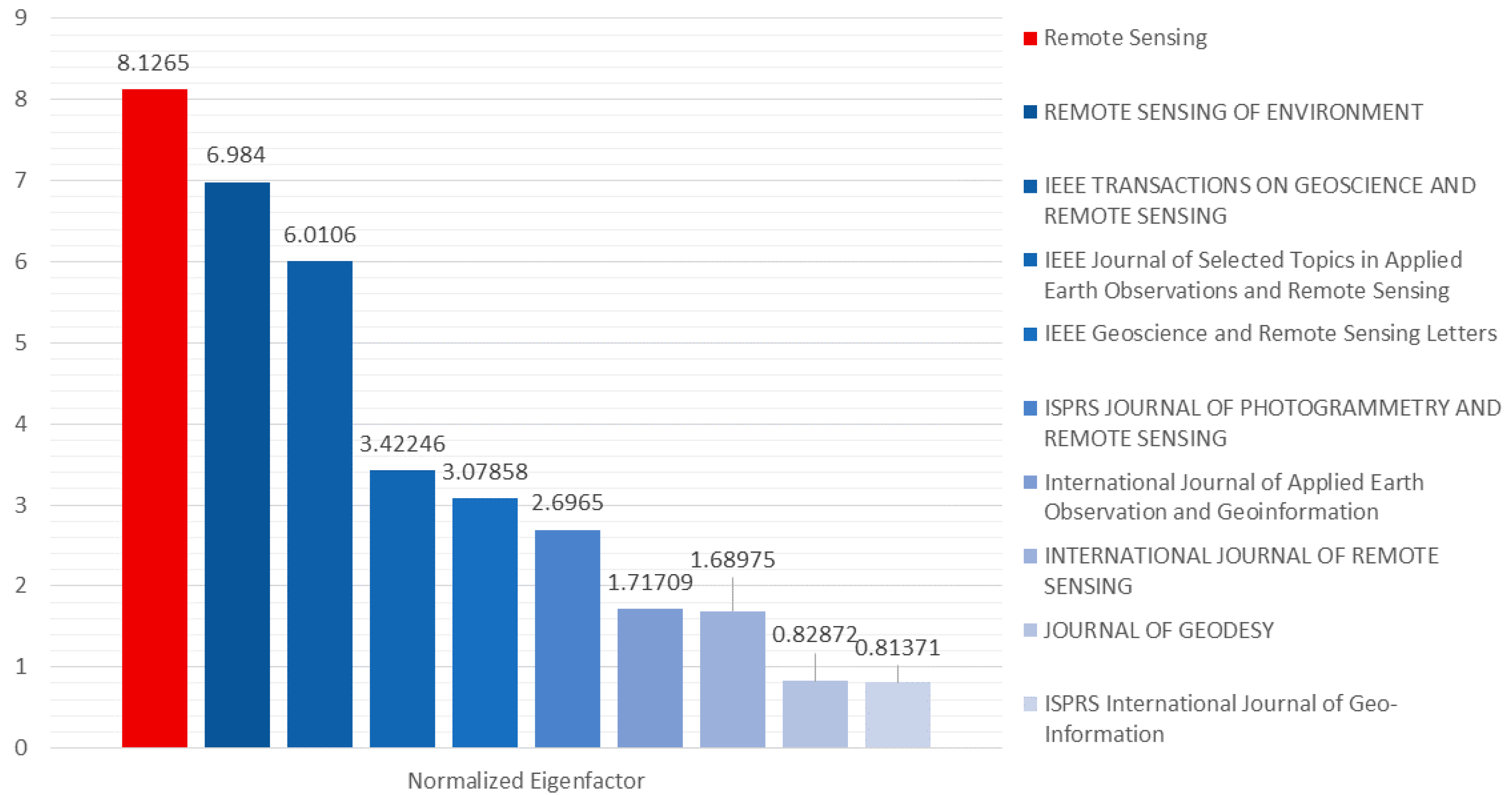
 [Green Version]
Figure 1. Number of submissions and publications in the past three years for the Remote Sensing Open Access Journal of MDPI.
Remotesensing 12 02442 g001
Figure 2. Number of publication types in 2019 for the Remote Sensing Open Access Journal of MDPI.
Remotesensing 12 02442 g002
Figure 3. Number of monthly submissions and publications in 2019 for the Remote Sensing Open Access Journal of MDPI.
Remotesensing 12 02442 g003
Figure 4. Top 10 countries/territories based on the percentage of author distribution in 2018 vs. 2019 for the Remote Sensing Open Access Journal of MDPI.
Remotesensing 12 02442 g004
Figure 5. The average publication time (APT, blue), median publication time (MPT, red), and time from submission to first decision (TFD, green) in the past three years.
Remotesensing 12 02442 g005
Figure 6. The new Special Issues (SIs) set up and the rate of publications for SIs in the past three years in the Remote Sensing Open Access Journal of MDPI.
Remotesensing 12 02442 g006
Figure 7. The top 12 journals under the category “Remote Sensing” based on Impact Factor (2019). Data were calculated from Web of Science on 13 July 2020.
Remotesensing 12 02442 g007
Figure 8. The top 10 journals under the category “Remote Sensing” based on Eigenfactor score (2019). Data were calculated from Web of Science on 13 July 2020.
Remotesensing 12 02442 g008
Figure 9. The top 10 journals under the category “Remote Sensing” based on normalized Eigenfactor (2019). Data were calculated from Web of Science on 13 July 2020.
Remotesensing 12 02442 g009
Figure 10. The top 10 journals under the category “Remote Sensing” based on Article Influence Score (2019). Data were calculated from Web of Science on 13 July 2020.
Remotesensing 12 02442 g010
Table 1. Critical remote sensing international journal performance parameters.
RankFull Journal TitleJournal Impact Factor AEigenfactor Score BNormalized Eigenfactor C ScoreArticle Influence Score DTotal CitesIncrease in Cites in
2019 Compared to 2018
20192018
1IEEE Geoscience and Remote Sensing Magazine130.003670.447742.9961304952352
2Remote Sensing of Environment9.0850.057246.9842.11162697544828215
3ISPRS Journal of Photogrammetry and Remote Sensing7.3190.02212.69651.79913946115762370
4GIScience & Remote Sensing5.9650.002090.256050.79514471183264
5IEEE Transactions on Geoscience and Remote Sensing5.8550.049266.01061.37146565437412824
6Remote Sensing in Ecology and Conservation50.001370.16745Not Available440N/A-
7Journal of Geodesy4.8060.006790.828721.33260005092908
8International Journal of Applied Earth Observation and Geoinformation4.650.014071.717091.166907273841688
9Remote Sensing4.5090.066618.12650.927360832356712516
10IEEE Geoscience and Remote Sensing Letters3.8330.025233.078580.90113781122171564
11IEEE Journal of Selected Topics in Applied Earth Observations and Remote Sensing3.8270.028053.422460.9651157996711908
12Geocarto International3.7890.002390.292760.51519081380528
13GPS Solutions3.610.00510.6230.85936902871819
14International Journal of Digital Earth3.0970.002620.319820.67817181512206
15International Journal of Remote Sensing2.9760.013851.689750.56824676222122464
16European Journal of Remote Sensing2.8080.001660.203350.482889644245
17Remote Sensing Letters2.2980.0040.488360.53420751636439
18ISPRS International Journal of Geo-Information2.2390.006660.813710.396373021961534
19Canadian Journal of Remote Sensing2.1260.001860.227610.67824652326139
20Photogrammetric Record1.8670.000690.084450.532821871−50
21Navigation-Journal of the Institute of Navigation1.70.000860.105570.4274165091
22Survey Review1.660.000910.111260.295752618134
23Spatial Statistics1.6560.003360.410550.991661504157
24Journal of Spatial Science1.4050.000570.070540.3913563560
25PFG-Journal of Photogrammetry Remote Sensing and Geoinformation Science1.3950.000140.018210.275613922
26Journal of Applied Remote Sensing1.360.004470.545470.27227532521232
27Marine Geodesy1.3220.000960.117460.4311084104242
28Radio Science1.3050.003340.407960.44548885484−596
29Photogrammetric Engineering and Remote Sensing1.2650.003350.409870.7970007002−2
30Journal of the Indian Society of Remote Sensing0.9970.001330.162480.18813021013289
Note: A = Journal Impact Factor: Number of times all the articles that are published in the last two years (i.e., 2017 and 2018) in a journal are cited this year (i.e., 2019) by any journal in the JCR database divided by the total number of articles published. B = Eigenfactor score: The Eigenfactor Score calculation is based on the number of times articles from the journal published in the past five years have been cited in the JCR year (2019), but it also considers which journals have contributed these citations so that highly cited journals will influence the network more than lesser cited journals. References from one article in a journal to another article from the same journal are removed, so that Eigenfactor Scores are not influenced by journal self-citation. C = Normalized Eigenfactor: The Normalized Eigenfactor Score is the Eigenfactor score normalized, by rescaling the total number of journals in the JCR (2019) each year, so that the average journal has a score of 1. Journals can then be compared and influence measured by their score relative to 1. For example, Remote Sensing Journal of MDPI which has a normalized eigenfactor of 8.1265, means that the journal is 8.1265 times as influencial as the average journal in the Journal Citation Report (JRC). D = Article Influence Score: Measures the average influence per article of the papers published in the journal over the first five years after publication. Green color highlight indicates the rank 1 for each performance parameter. Credits for the definitions A,B,C,D above: References [1,2,3,4].
Table 2. The newly set up Special Issues (SIs) and the rate of publications for SIs in the past three years.
SI TitleGuest EditorsPublication
Advances of Multi-Temporal Remote Sensing in Vegetation and Agriculture ResearchJiali Shang, Jiangui Liu, Catherine Champagne, Taifeng Dong, John Kovacs28
Concurrent Positioning, Mapping and Perception of Multi-Source Data Fusion for Smart ApplicationsJingbin Liu, Yuanxi Yang, Juha Hyyppä, Naser El-Sheimy21
Convolutional Neural Networks Applications in Remote SensingDavide Cozzolino, Raffaele Gaetano, Francescopaolo Sica20
Global Navigation Satellite Systems for Earth Observing SystemJianghui Geng, Maorong Ge, Jennifer Haase, Weiping Jiang26
High-precision GNSS: Methods, Open Problems and Geoscience ApplicationsXingxing Li, Jacek Paziewski, Mattia Crespi35
Table 3. The summary of team construction in the past two years.
Position201820192018–2019 Increase
EiC110
SEiC8135
Advisory Board Member385
Senior Associate Editor440
Associate Editor305727
Editorial Board Member280605325
Topic Editor01717
Reviewer Board Member011071107

