Sentinel-1 Change Detection Analysis for Cyclone Damage Assessment in Urban Environments
Abstract
1. Introduction
“The method is specifically well suited for situations where man-made targets appear or disappear against a natural background, an important application of Change Detection in satellite data”[3]
2. Data
2.1. Sentinel-1
2.2. Manually Tagged Damage
2.3. Auxiliary Data
2.3.1. Spatial Characteristics of Beira
2.3.2. OpenStreetMap—Buildings
2.3.3. World Weather Online
3. SAR Methodology
4. Results
4.1. Weather and Change Detection
4.2. Different Types of Change Detections
4.3. Change Detection Compared to Manually Tagged Damages
4.4. Socio-Economic Characteristics of Impact
5. Discussion
6. Conclusions
Author Contributions
Funding
Acknowledgments
Conflicts of Interest
Appendix A
Appendix B
- Apply-Orbit-File
- Subset
- Remove-GRD-Border-Noise
- Thermal-Noise-Removal
- Calibration
- Terrain-Correction
References
- Saito, K.; Spence, R.J.; Going, C.; Markus, M. Using high-resolution satellite images for post-earthquake building damage assessment: A study following the 26 January 2001 Gujarat earthquake. Earthq. Spectra 2004, 20, 145–169. [Google Scholar] [CrossRef]
- Ge, P.; Gokon, H.; Meguro, K. A review on synthetic aperture radar-based building damage assessment in disasters. Remote Sens. Environ. 2020, 240, 111693. [Google Scholar] [CrossRef]
- Canty, M.J.; Nielsen, A.A.; Conradsen, K.; Skriver, H. Statistical Analysis of Changes in Sentinel-1 Time Series on the Google Earth Engine. Remote Sens. 2019, 12, 46. [Google Scholar] [CrossRef]
- Plank, S. Rapid damage assessment by means of multi-temporal SAR—A comprehensive review and outlook to Sentinel-1. Remote Sens. 2014, 6, 4870–4906. [Google Scholar] [CrossRef]
- Washaya, P.; Balz, T.; Mohamadi, B. Coherence change-detection with sentinel-1 for natural and anthropogenic disaster monitoring in urban areas. Remote Sens. 2018, 10, 1026. [Google Scholar] [CrossRef]
- Morelli, S.; Del Soldato, M.; Bianchini, S.; Pazzi, V.; Krymbi, E.; Shpori, E.; Casagli, N. Detection of Seasonal Inundations by Satellite Data at Shkoder Urban Area, North Albania for Sustainable Management. Sustainability 2019, 11, 4454. [Google Scholar] [CrossRef]
- Li, Y.; Martinis, S.; Wieland, M.; Schlaffer, S.; Natsuaki, R. Urban flood mapping using SAR intensity and interferometric coherence via Bayesian network fusion. Remote Sens. 2019, 11, 2231. [Google Scholar] [CrossRef]
- Trianni, G.; Gamba, P. Damage detection from SAR imagery: Application to the 2003 Algeria and 2007 Peru earthquakes. Int. J. Navig. Obs. 2008, 2008. [Google Scholar] [CrossRef]
- Dong, L.; Shan, J. A comprehensive review of earthquake-induced building damage detection with remote sensing techniques. ISPRS J. Photogramm. Remote Sens. 2013, 84, 85–99. [Google Scholar] [CrossRef]
- Bignami, C.; Chini, M.; Pierdicca, N.; Stramondo, S. Comparing and combining the capability of detecting earthquake damages in urban areas using SAR and optical data. In Proceedings of the IEEE International Geoscience and Remote Sensing Symposium, Anchorage, AK, USA, 20–24 September 2004; IEEE: Piscataway, NJ, USA, 2004; Volume 1. [Google Scholar]
- Grey, W.; Luckman, A.; Holland, D. Mapping urban change in the UK using satellite radar interferometry. Remote Sens. Environ. 2003, 87, 16–22. [Google Scholar] [CrossRef]
- Conradsen, K.; Nielsen, A.A.; Schou, J.; Skriver, H. A test statistic in the complex Wishart distribution and its application to change detection in polarimetric SAR data. IEEE Trans. Geosci. Remote Sens. 2003, 41, 4–19. [Google Scholar] [CrossRef]
- Conradsen, K.; Nielsen, A.A.; Skriver, H. Determining the points of change in time series of polarimetric SAR data. IEEE Trans. Geosci. Remote Sens. 2016, 54, 3007–3024. [Google Scholar] [CrossRef]
- Xie, S.; Duan, J.; Liu, S.; Dai, Q.; Liu, W.; Ma, Y.; Guo, R.; Ma, C. Crowdsourcing rapid assessment of collapsed buildings early after the earthquake based on aerial remote sensing image: A case study of yushu earthquake. Remote Sens. 2016, 8, 759. [Google Scholar] [CrossRef]
- Shao, W.; Hu, Y.; Yang, J.; Nunziata, F.; Sun, J.; Li, H.; Zuo, J. An empirical algorithm to retrieve significant wave height from Sentinel-1 synthetic aperture radar imagery collected under cyclonic conditions. Remote Sens. 2018, 10, 1367. [Google Scholar] [CrossRef]
- ESA. Sentinel-1 Observation Scenario. Available online: https://sentinel.esa.int/web/sentinel/missions/sentinel-1/observation-scenario (accessed on 1 May 2020).
- ESA. User Guides—Sentinel-1 SAR—Level-1 Ground Range Detected—Sentinel Online. Available online: https://sentinel.esa.int/web/sentinel/user-guides/sentinel-1-sar/resolutions/level-1-ground-range-detected (accessed on 1 May 2020).
- Sohnesen, T.P.; Fisker, P.; Malmgren-Hansen, D. Using Satellite Data to Guide Urban Poverty Reduction. In Proceedings of the IARIW-World Bank Conference: New Approaches to Defining and Measuring Poverty in a Growing World, Washington, DC, USA, 7–8 November 2019. [Google Scholar]
- OpenStreetMap Contributors. 2017. Available online: https://www.openstreetmap.org (accessed on 22 April 2020).
- Esch, T.; Taubenböck, H.; Roth, A.; Heldens, W.; Felbier, A.; Schmidt, M.; Mueller, A.A.; Thiel, M.; Dech, S.W. TanDEM-X mission-new perspectives for the inventory and monitoring of global settlement patterns. J. Appl. Remote Sens. 2012, 6, 061702. [Google Scholar] [CrossRef]
- Esch, T.; Marconcini, M.; Felbier, A.; Roth, A.; Heldens, W.; Huber, M.; Schwinger, M.; Taubenböck, H.; Müller, A.; Dech, S. Urban footprint processor—Fully automated processing chain generating settlement masks from global data of the TanDEM-X mission. IEEE Geosci. Remote Sens. Lett. 2013, 10, 1617–1621. [Google Scholar] [CrossRef]
- Weather Data Retrieved from WORLD WEATHER ONLINE. 2017. Available online: https://www.worldweatheronline.com/ (accessed on 25 March 2020).
- Conradsen, K.; Nielsen, A.A.; Skriver, H. Omnibus Change Detection in Block Diagonal Covariance Matrix PolSAR Data from Sentinel-1 and Radarsat-2. 2019. in preparation. [Google Scholar]
- Nielsen, A.A.; Skriver, H.; Conradsen, K. The Loewner Order and Direction of Detected Change in Sentinel-1 and Radarsat-2 Data. IEEE Geosci. Remote Sens. Lett. 2019, 17, 242–246. [Google Scholar] [CrossRef]
- Schober, P.; Boer, C.; Schwarte, L.A. Correlation coefficients: Appropriate use and interpretation. Anesth. Analg. 2018, 126, 1763–1768. [Google Scholar] [CrossRef] [PubMed]
- Facebook Connectivity Lab, Center for International Earth Science Information Network, Columbia University. High Resolution Settlement Layer (HRSL); Data Source: 2016 DigitalGlobe; Colombia University: New York, NY, USA, 2016; Available online: https://www.ciesin.columbia.edu/data/hrsl/ (accessed on 26 July 2020).


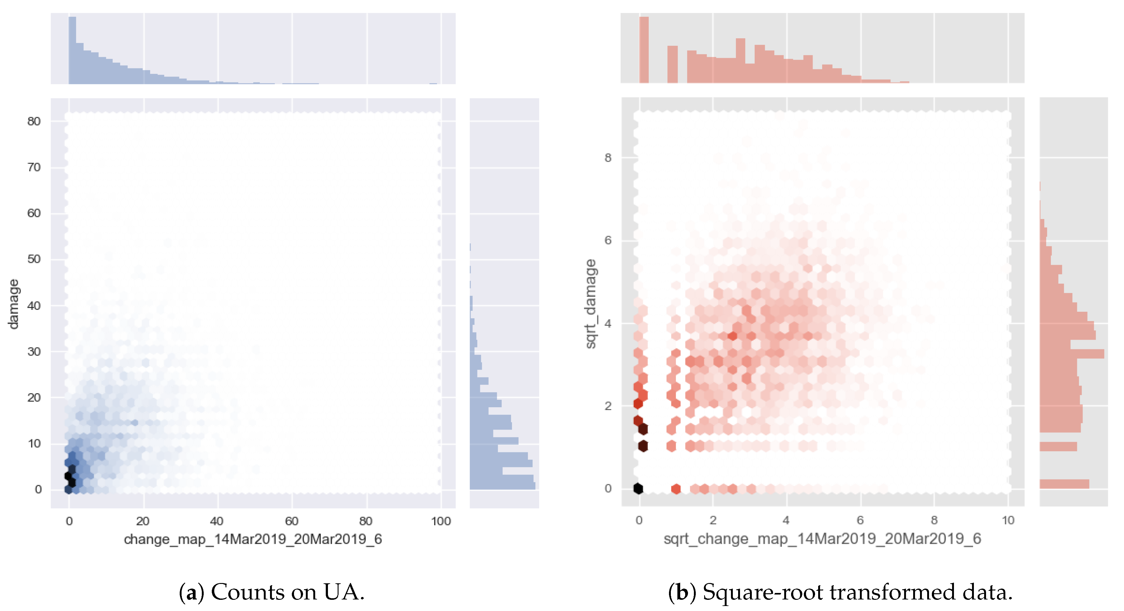
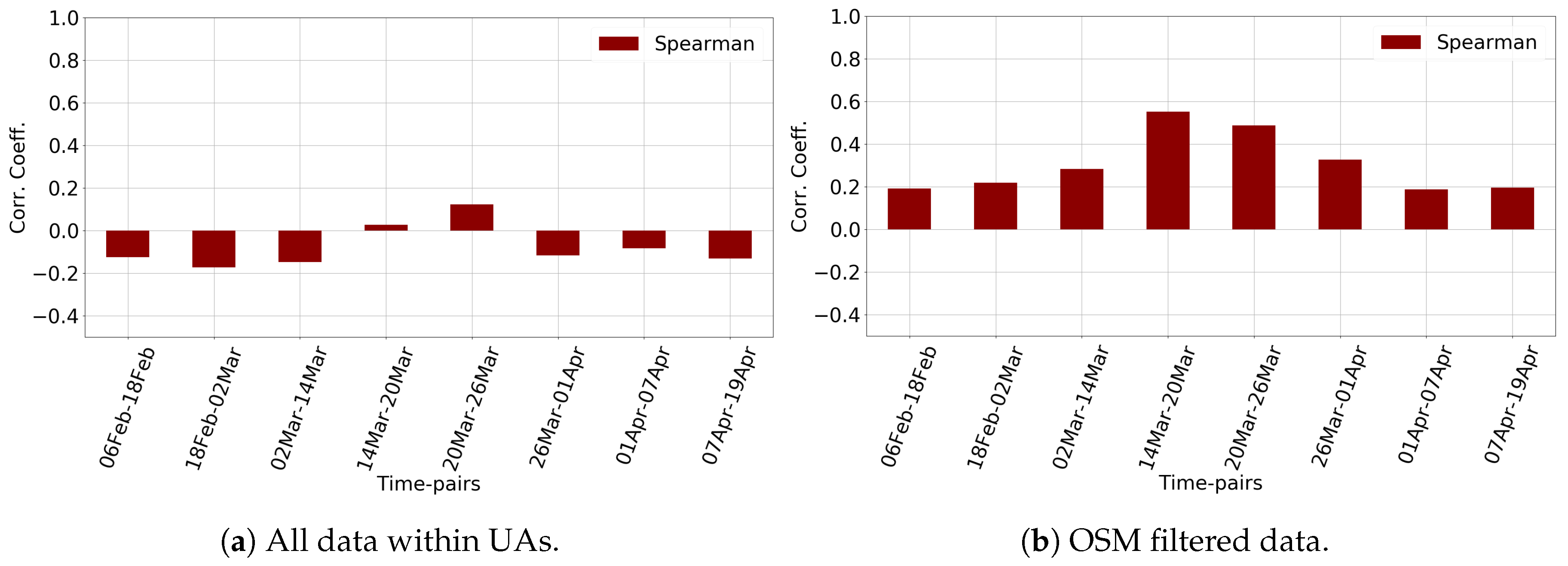
| Manual Tags | Changes | Poverty | Dist. to Coast | Construction Density | |
|---|---|---|---|---|---|
| Manual tags | 1.00 | 0.55 | 0.20 | −0.02 | 0.71 |
| Changes | 1.00 | 0.41 | −0.30 | 0.76 | |
| Poverty | 1.00 | −0.51 | 0.54 | ||
| Dist. to coast | 1.00 | −0.33 | |||
| Construction density | 1.00 |
© 2020 by the authors. Licensee MDPI, Basel, Switzerland. This article is an open access article distributed under the terms and conditions of the Creative Commons Attribution (CC BY) license (http://creativecommons.org/licenses/by/4.0/).
Share and Cite
Malmgren-Hansen, D.; Sohnesen, T.; Fisker, P.; Baez, J. Sentinel-1 Change Detection Analysis for Cyclone Damage Assessment in Urban Environments. Remote Sens. 2020, 12, 2409. https://doi.org/10.3390/rs12152409
Malmgren-Hansen D, Sohnesen T, Fisker P, Baez J. Sentinel-1 Change Detection Analysis for Cyclone Damage Assessment in Urban Environments. Remote Sensing. 2020; 12(15):2409. https://doi.org/10.3390/rs12152409
Chicago/Turabian StyleMalmgren-Hansen, David, Thomas Sohnesen, Peter Fisker, and Javier Baez. 2020. "Sentinel-1 Change Detection Analysis for Cyclone Damage Assessment in Urban Environments" Remote Sensing 12, no. 15: 2409. https://doi.org/10.3390/rs12152409
APA StyleMalmgren-Hansen, D., Sohnesen, T., Fisker, P., & Baez, J. (2020). Sentinel-1 Change Detection Analysis for Cyclone Damage Assessment in Urban Environments. Remote Sensing, 12(15), 2409. https://doi.org/10.3390/rs12152409


