Supporting Urban Weed Biosecurity Programs with Remote Sensing


Abstract
1. Introduction
1.1. Background
1.2. Paper Aims and Structure
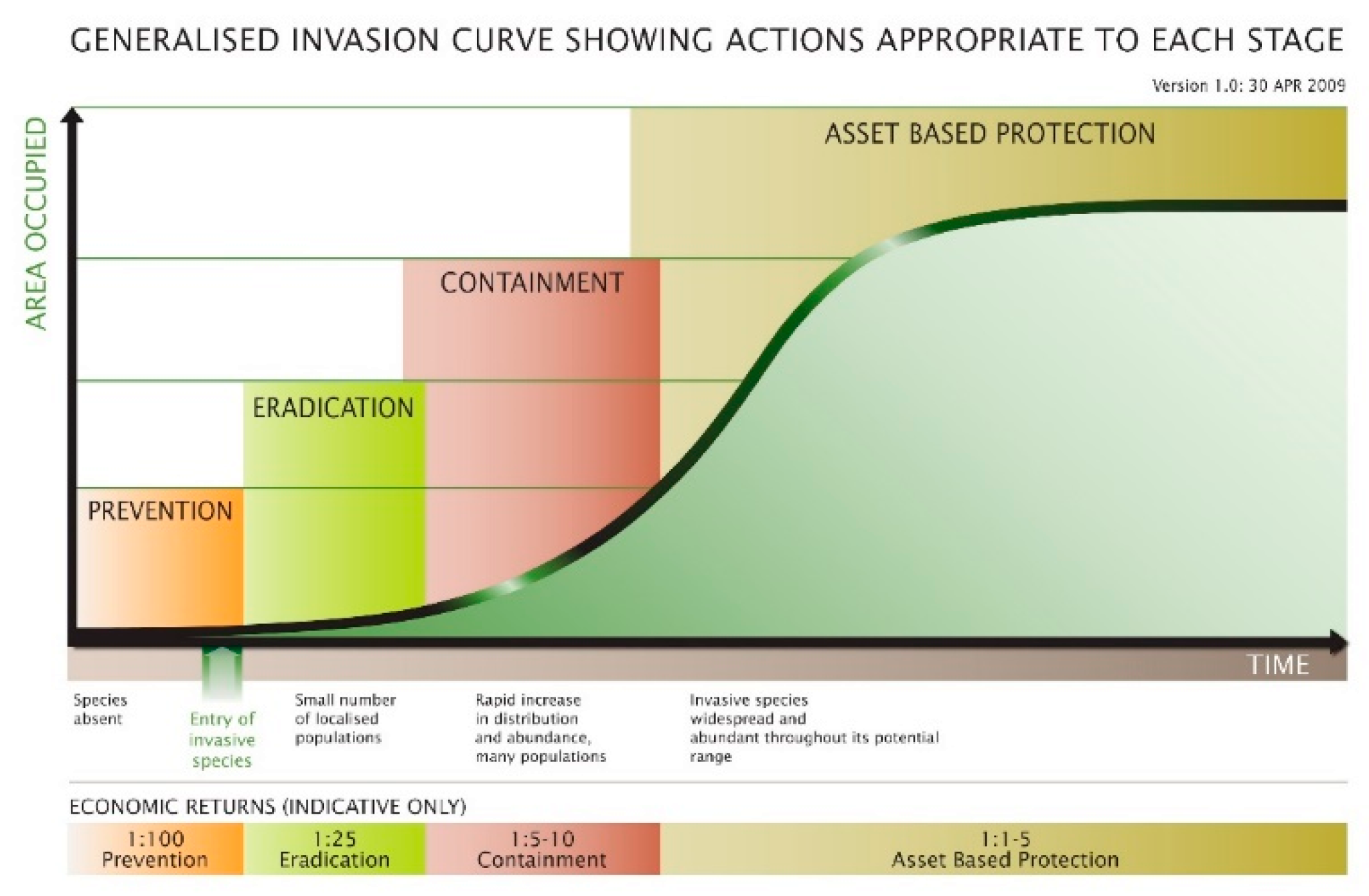
2. Weed Biosecurity in Urban and Peri-Urban Environments
- Discrimination of weed species from other vegetation, with identification robust enough to minimize both false positive and false negative identification.
- The ability to detect small infestations of target weed species.
- Repeatability of the approach both over time at the same location and application in different geographical areas.
- Flexibility to survey larger areas as well as small localized sites to support both monitoring of known populations and surveillance to detect previously unidentified populations.
3. Remote Sensing to Support Weed Biosecurity Programs
- Detection: species detection at landscape, local and site scales.
- Monitoring: assessment of temporal change and population monitoring.
- Management and eradication: individual plant detection and development of technology to automate weed eradication or management actions.
3.1. Detection
3.1.1. Spatial Scale and Image Resolution
3.1.2. Spectral and Phenological Information
3.1.3. Image Classification
- Minimum number of samples per class.
- Distribution (equal or unequal) of samples across classes.
- The sampling design used to collect ground data (random, targeted, stratified, clustered sampling).
- The relationship between the ground samples collected and the spatial resolution of the imagery to be used.
- The accuracy of the ground data.
3.2. Monitoring
3.3. Eradication and Management
3.4. Challenges and Opportunities
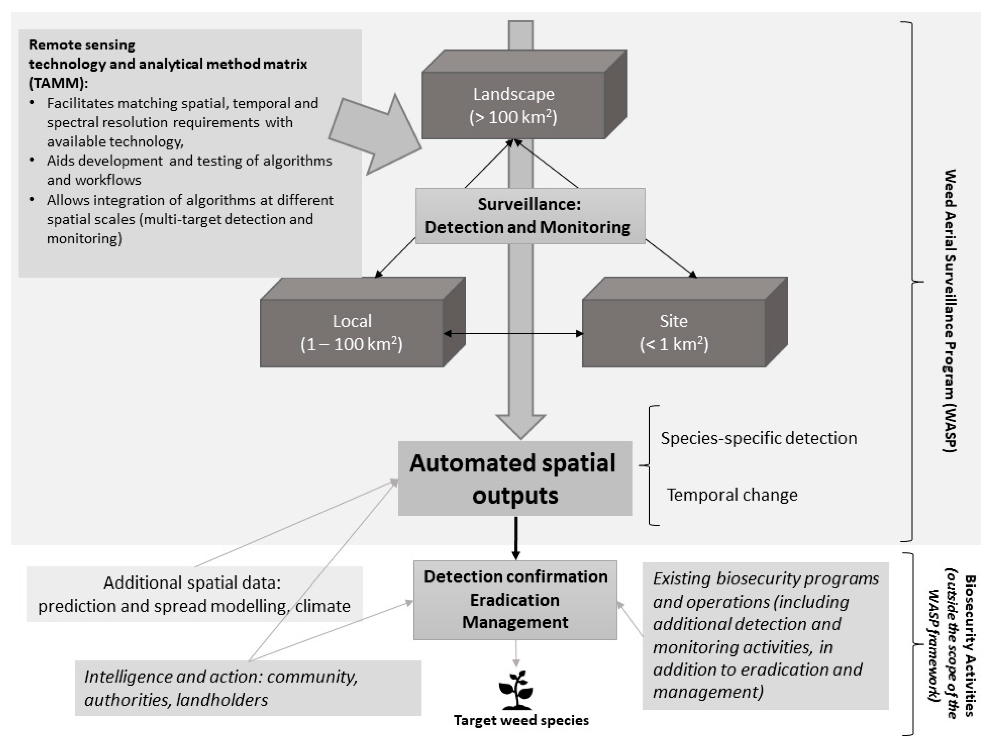
4. Conceptual Framework for a Weed Aerial Surveillance Program (WASP)
- Development and testing of workflows and image classification algorithms to detect and monitor weed species.
- Production of spatial outputs which can then be used in existing biosecurity weed management programs.
- The temporal and spectral resolution of the imagery.
- The swath of the imagery captured.
5. Concluding Remarks
Author Contributions
Funding
Acknowledgments
Conflicts of Interest
References
- McLeod, R. Annual Costs of Weeds in Australia; Centre for Invasive Species Solutions: Canberra, Australia, 2018.
- Baider, C.; Florens, F.V. Control of invasive alien weeds averts imminent plant extinction. Biol. Invasions 2011, 13, 2641–2646. [Google Scholar] [CrossRef]
- Xie, Y.; Zhang, A.; Welsh, W. Mapping Wetlands and Phragmites Using Publically Available Remotely Sensed Images. Photogramm. Eng. Remote Sens. 2015, 81, 69–78. [Google Scholar] [CrossRef]
- Ngom, R.; Gosselin, P. Development of a remote sensing-based method to map likelihood of common ragweed (Ambrosia artemisiifolia) presence in urban areas. IEEE J. Sel. Top. Appl. Earth Obs. Remote Sens. 2013, 7, 126–139. [Google Scholar] [CrossRef]
- Dimitrov, S.; Georgiev, G.; Georgieva, M.; Gluschkova, M.; Chepisheva, V.; Mirchev, P.; Zhiyanski, M. Integrated assessment of urban green infrastructure condition in Karlovo urban area by in-situ observations and remote sensing. One Ecosyst. 2018, 3, e21610. [Google Scholar] [CrossRef]
- Dures, S.G.; Cumming, G.S. The confounding influence of homogenising invasive species in a globally endangered and largely urban biome: Does habitat quality dominate avian biodiversity? Biol. Conserv. 2010, 143, 768–777. [Google Scholar] [CrossRef]
- Blood, K.; James, R.; Panetta, D.F.; Sheehan, M.; Adair, R.; Gold, B. Early Invader Manual: Managing Early Invader Environmental Weeds in Victoria; Department of Environment, Land, Water and Planning: Victoria, Australia, 2019.
- PPWCMA. Port Phillip and Westen Port Invasive Plants & Animals Strategy; Port Phillip and Westernpot Catchment Management Authority (PPWCMA): Frankston, Victoria, 2011.
- Laidlaw, M.J.; Louden, M.A.; Bean, A.R. A Handbook for the Weed Spotters Network Queensland; Queensland Herbarium: Toowong, QLD, Australia, 2019.
- Hulme, P.E. Plant invasions in New Zealand: Global lessons in prevention, eradication and control. Biol. Invasions 2020, 22, 1539–1562. [Google Scholar] [CrossRef]
- USDA. Animal and Plant Health Inspection Service: Noxious Weeds Program. Available online: https://www.aphis.usda.gov/aphis/ourfocus/planthealth/plant-pest-and-disease-programs/pests-and-diseases/sa_weeds/sa_noxious_weeds_program/ct_noxious_weeds_program_home (accessed on 21 May 2020).
- University of Georgia—Centre for Invasive Species and Ecosystem Health; University of Florida—Centre for Aquatic and Invasive Plants. North America Invasive Species Network. Available online: https://www.naisn.org/ (accessed on 21 May 2020).
- Groves, R.H.C.; Hosking, J.R.; Batianoff, G.N.; Cooke, D.A.; Cowie, I.D.; Johnson, R.W.; Keighery, G.J.; Lepschi, B.J.; Mitchell, A.A.; Moerkerk, M.; et al. Weed Categories for Natural and Agricultural Ecosystem Management; Bureau of Rural Sciences: Canberra, Australia, 2003. [Google Scholar]
- Weiss, J.; Edgar, B.; Hunt, T.; Morfe, T. Victoria’s noxious weed review: Roll out not fall out. In Proceedings of the 14th Australian Weeds Conference, (Weed Society of NSW, Sydney), Wagga Wagga, Australia, 6–9 September 2004; Sindel, B.M., Johnson, S.B., Eds.; pp. 707–710. [Google Scholar]
- Henderson, L. Alien Weeds And Invasive Plants; Plant Protection Research Institute, Agricultural Research Council: Cape Town, South Africa, 2001. [Google Scholar]
- European Union. Invasive Alien Species of Union Concern; Publications Office of the European Union: Luxembourg, 2017. [Google Scholar]
- Gaertner, M.; Wilson, J.R.U.; Cadotte, M.W.; MacIvor, J.S.; Zenni, R.D.; Richardson, D.M. Non-native species in urban environments: Patterns, processes, impacts and challenges. Biol. Invasions 2017, 19, 3461–3469. [Google Scholar] [CrossRef]
- Clements, D.; Dugdale, T.M.; Hunt, T.D. Growth of aquatic alligator weed (Alternanthera philoxeroides) over 5 years in south-east Australia. Aquat. Invasions 2011, 6, 77–82. [Google Scholar] [CrossRef]
- McKirdy, S.J.; Sharma, S.B.; Bayliss, K.L. Quarantine and Biosecurity; Academic Press: Cambridge, MA, USA, 2014. [Google Scholar]
- Kumschick, S.; Richardson, D.M. Species-based risk assessments for biological invasions: Advances and challenges. Divers. Distrib. 2013, 19, 1095–1105. [Google Scholar] [CrossRef]
- Dodd, A.J.; Ainsworth, N.; Burgman, M.A.; McCarthy, M.A. Plant extirpation at the site scale: Implications for eradication programmes. Divers. Distrib. 2015, 21, 151–162. [Google Scholar] [CrossRef]
- Thomas, M.L.; Gunawardene, N.; Horton, K.; Williams, A.; O′Connor, S.; McKirdy, S.J.; van der Merwe, J. Many eyes on the ground: Citizen science is an effective early detection tool for biosecurity. Biol. Invasions 2017, 19, 2751–2765. [Google Scholar] [CrossRef]
- Panetta, D.F. Evaluating the performance of weed containment programmes. Divers. Distrib. 2012, 18, 1024–1032. [Google Scholar] [CrossRef]
- Morfe, T.A.; Weiss, J. Optimising government intestment at different stages of the weed invasion process. In Proceedings of the 15th Australian Weeds Conference, Adelaide, Australia, 24–28 September 2006; pp. 87–90. [Google Scholar]
- Page, A.R.; Lacey, K.L. Economic Impact Assessment of Australian Weed Biological Control Effort. Final Report; KL/AEC Group Ltd., CRC for Australian Weed Management: Glen Osmond, South Australia, 2005. [Google Scholar]
- Victorian Government. Invasive Plants and Animals Policy Framework. Available online: http://agriculture.vic.gov.au/agriculture/pests-diseases-and-weeds/protecting-victoria/invasive-plants-and-animals/invasive-plants-and-animals-policy-framework (accessed on 14 May 2020).
- Pickett, S.T.; Cadenasso, M.L.; Grove, J.M.; Nilon, C.H.; Pouyat, R.V.; Zipperer, W.C.; Costanza, R. Urban ecological systems: Linking terrestrial ecological, physical, and socioeconomic components of metropolitan areas. Annu. Rev. Ecol. Syst. 2001, 32, 127–157. [Google Scholar] [CrossRef]
- McLaren, D.; Lefoe, G.; Ede, F.; Dugdale, T. Highlighting the Complexity of Interactions between Peri-Urban Environments and Weed Management Using Case Studies from Southern Victoria. In Conflict and Change in Australia’s Peri-Urban Landscapes; Routledge: Abingdon, UK, 2016; pp. 207–221. [Google Scholar]
- Lawes, R.A.; Wallace, J.F. Monitoring an invasive perennial at the landscape scale with remote sensing. Ecol. Manag. Restor. 2008, 9, 53–59. [Google Scholar] [CrossRef]
- Brinkhoff, J.; Hornbuckle, J.; Barton, J.L. Assessment of Aquatic Weed in Irrigation Channels Using UAV and Satellite Imagery. Water 2018, 10, 1497. [Google Scholar] [CrossRef]
- Khare, S.; Latifi, H.; Ghosh, S.K. Multi-scale assessment of invasive plant species diversity using Pléiades 1A, RapidEye and Landsat-8 data. Geocarto Int. 2018, 33, 681–698. [Google Scholar] [CrossRef]
- Walsh, S.J.; McCleary, A.L.; Mena, C.F.; Shao, Y.; Tuttle, J.P.; González, A.; Atkinson, R. QuickBird and Hyperion data analysis of an invasive plant species in the Galapagos Islands of Ecuador: Implications for control and land use management. Remote Sens. Environ. 2008, 112, 1927–1941. [Google Scholar] [CrossRef]
- Ahsan, N.; Xu, Z.; Murphy, R.; Sukkarieh, S. Weed Detection and Classification Using Low Altitude Aerial Images; Northern Tablelands Local Land Service and Australian Centre for Field Robotics, The University of Sydney: Sydney, Australia, 2016. [Google Scholar]
- Bertacchi, A.; Giannini, V.; Di Franco, C.; Silvestri, N. Using unmanned aerial vehicles for vegetation mapping and identification of botanical species in wetlands. Landsc. Ecol. Eng. 2019, 15, 231–240. [Google Scholar] [CrossRef]
- Kaneko, K.; Nohara, S. Review of effective vegetation mapping using the UAV (unmanned aerial vehicle) method. J. Geogr. Inf. Syst. 2014, 6, 733–742. [Google Scholar] [CrossRef]
- Fernández-Quintanilla, C.; Peña, J.M.; Andújar, D.; Dorado, J.; Ribeiro, A.; López-Granados, F. Is the current state of the art of weed monitoring suitable for site-specific weed management in arable crops? Weed Res. 2018, 58, 259–272. [Google Scholar] [CrossRef]
- Shouse, M.; Liang, L.; Fei, S. Identification of understory invasive exotic plants with remote sensing in urban forests. Int. J. Appl. Earth Obs. Geoinf. 2013, 21, 525–534. [Google Scholar] [CrossRef]
- Müllerová, J.; Brůna, J.; Bartaloš, T.; Dvořák, P.; Vítková, M.; Pyšek, P. Timing is important: Unmanned aircraft vs. satellite imagery in plant invasion monitoring. Front. Plant Sci. 2017, 8, 887. [Google Scholar] [CrossRef] [PubMed]
- Hung, C.; Xu, Z.; Sukkarieh, S. Feature Learning Based Approach for Weed Classification Using High Resolution Aerial Images from a Digital Camera Mounted on a UAV. Remote Sens. 2014, 6, 12037–12054. [Google Scholar] [CrossRef]
- Matese, A.; Toscano, P.; Di Gennaro, S.F.; Genesio, L.; Vaccari, F.P.; Primicerio, J.; Belli, C.; Zaldei, A.; Bianconi, R.; Gioli, B. Intercomparison of UAV, Aircraft and Satellite Remote Sensing Platforms for Precision Viticulture. Remote Sens. 2015, 7, 2971–2990. [Google Scholar] [CrossRef]
- Malmstrom, C.M.; Butterfield, H.S.; Planck, L.; Long, C.W.; Eviner, V.T. Novel fine-scale aerial mapping approach quantifies grassland weed cover dynamics and response to management. PLoS ONE 2017, 12, e0181665. [Google Scholar] [CrossRef]
- Sandino, J.; Gonzalez, F.; Mengersen, K.; Gaston, K.J. UAVs and Machine Learning Revolutionising Invasive Grass and Vegetation Surveys in Remote Arid Lands. Sensors 2018, 18, 605. [Google Scholar] [CrossRef]
- Tsai, F.; Chou, M.J. Texture augmented analysis of high resolution satellite imagery in detecting invasive plant species. J. Chin. Inst. Eng. 2006, 29, 581–592. [Google Scholar] [CrossRef]
- Singh, K.K.; Davis, A.J.; Meentemeyer, R.K. Detecting understory plant invasion in urban forests using LiDAR. Int. J. Appl. Earth Obs. Geoinf. 2015, 38, 267–279. [Google Scholar] [CrossRef]
- Alonzo, M.; Bookhagen, B.; Roberts, D.A. Urban tree species mapping using hyperspectral and lidar data fusion. Remote Sens. Environ. 2014, 148, 70–83. [Google Scholar] [CrossRef]
- Chance, C.M.; Coops, N.C.; Plowright, A.A.; Tooke, T.R.; Christen, A.; Aven, N. Invasive shrub mapping in an urban environment from hyperspectral and LiDAR-derived attributes. Front. Plant Sci. 2016, 7, 1528. [Google Scholar] [CrossRef]
- Bradley, B.A. Remote detection of invasive plants: A review of spectral, textural and phenological approaches. Biol. Invasions 2014, 16, 1411–1425. [Google Scholar] [CrossRef]
- Singh, K.K.; Chen, Y.-H.; Smart, L.; Gray, J.; Meentemeyer, R.K. Intra-annual phenology for detecting understory plant invasion in urban forests. ISPRS J. Photogramm. Remote Sens. 2018, 142, 151–161. [Google Scholar] [CrossRef]
- Lass, L.W.; Prather, T.S.; Glenn, N.F.; Weber, K.T.; Mundt, J.T.; Pettingill, J. A review of remote sensing of invasive weeds and example of the early detection of spotted knapweed (Centaurea maculosa) and babysbreath (Gypsophila paniculata) with a hyperspectral sensor. Weed Sci. 2005, 53, 242–251. [Google Scholar] [CrossRef]
- Hamilton, M.; Matthews, R.; Caldwell, J. Needle in a haystack-detecting hawkweeds using drones. In Proceedings of the 21st Australasian Weeds Conference, Manly, Sydney, Australia, 9–12 September 2018; pp. 9–13. [Google Scholar]
- Baron, J.; Hill, D.J.; Elmiligi, H. Combining image processing and machine learning to identify invasive plants in high-resolution images. Int. J. Remote Sens. 2018, 39, 5099–5118. [Google Scholar] [CrossRef]
- Artigas, F.; Pechmann, I.C. Balloon imagery verification of remotely sensed Phragmites australis expansion in an urban estuary of New Jersey, USA. Landsc. Urban Plan. 2010, 95, 105–112. [Google Scholar] [CrossRef]
- Khanna, S.; Santos, M.J.; Hestir, E.L.; Ustin, S.L. Plant community dynamics relative to the changing distribution of a highly invasive species, Eichhornia crassipes: A remote sensing perspective. Biol. Invasions 2012, 14, 717–733. [Google Scholar] [CrossRef]
- Cavalli, R.M.; Laneve, G.; Fusilli, L.; Pignatti, S.; Santini, F. Remote sensing water observation for supporting Lake Victoria weed management. J. Environ. Manag. 2009, 90, 2199–2211. [Google Scholar] [CrossRef]
- Dian Bah, M.; Hafiane, A.; Canals, R. Deep Learning with unsupervised data labeling for weeds detection on UAV images. arXiv 2018, arXiv:1805.12395. [Google Scholar]
- Truong, T.T.A.; Hardy, G.E.S.J.; Andrew, M.E. Contemporary Remotely Sensed Data Products Refine Invasive Plants Risk Mapping in Data Poor Regions. Front. Plant Sci. 2017, 8. [Google Scholar] [CrossRef]
- Clements, D.; Dugdale, T.; Hunt, T.; Fitch, R.; Hung, C.; Sukkarieh, S.; Xu, Z. Detection of alligator weed using an unmanned aerial vehicle. Plant Prot. Q. 2014, 29, 84–89. [Google Scholar]
- Müllerová, J.; Pyšek, P.; Jarošík, V.; Pergl, J. Aerial photographs as a tool for assessing the regional dynamics of the invasive plant species Heracleum mantegazzianum. J. Appl. Ecol. 2005, 42, 1042–1053. [Google Scholar] [CrossRef]
- Everitt, J.H.; Fletcher, R.S.; Elder, H.S.; Yang, C. Mapping giant salvinia with satellite imagery and image analysis. Environ. Monit. Assess. 2008, 139, 35–40. [Google Scholar] [CrossRef]
- Cuneo, P.; Jacobson, C.; Leishman, M. Landscape-scale detection and mapping of invasive African Olive (Olea europaea L. ssp. cuspidata Wall ex G. Don Ciferri) in SW Sydney, Australia using satellite remote sensing. Appl. Veg. Sci. 2009, 12, 145–154. [Google Scholar] [CrossRef]
- Gao, J.; Liao, W.; Nuyttens, D.; Lootens, P.; Vangeyte, J.; Pižurica, A.; He, Y.; Pieters, J.G. Fusion of pixel and object-based features for weed mapping using unmanned aerial vehicle imagery. Int. J. Appl. Earth Obs. Geoinf. 2018, 67, 43–53. [Google Scholar] [CrossRef]
- Kattenborn, T.; Lopatin, J.; Förster, M.; Braun, A.C.; Fassnacht, F.E. UAV data as alternative to field sampling to map woody invasive species based on combined Sentinel-1 and Sentinel-2 data. Remote Sens. Environ. 2019, 227, 61–73. [Google Scholar] [CrossRef]
- Murawaat, S.; Qureshi, A.; Ahmad, S.; Shahid, Y. Weed Detection Using SVMs. Eng. Technol. Appl. Sci. Res. 2018, 8, 2412–2416. [Google Scholar]
- Göktoǧan, A.H.; Sukkarieh, S.; Bryson, M.; Randle, J.; Lupton, T.; Hung, C. A Rotary-wing Unmanned Air Vehicle for Aquatic Weed Surveillance and Management. J. Intell. Robot. Syst. 2009, 57, 467. [Google Scholar] [CrossRef]
- Olsen, A.; Konovalov, D.A.; Philippa, B.; Ridd, P.; Wood, J.C.; Johns, J.; Banks, W.; Girgenti, B.; Kenny, O.; Whinney, J.; et al. DeepWeeds: A Multiclass Weed Species Image Dataset for Deep Learning. Sci. Rep. 2019, 9, 2058. [Google Scholar] [CrossRef]
- Teimouri, N.; Dyrmann, M.; Nielsen, P.R.; Mathiassen, S.K.; Somerville, G.J.; Jørgensen, R.N. Weed Growth Stage Estimator Using Deep Convolutional Neural Networks. Sensors 2018, 18, 1580. [Google Scholar] [CrossRef]
- Sa, I.; Chen, Z.; Popović, M.; Khanna, R.; Liebisch, F.; Nieto, J.; Siegwart, R. WeedNet: Dense Semantic Weed Classification Using Multispectral Images and MAV for Smart Farming. IEEE Robot. Autom. Lett. 2018, 3, 588–595. [Google Scholar] [CrossRef]
- Mountrakis, G.; Im, J.; Ogole, C. Support vector machines in remote sensing: A review. ISPRS J. Photogramm. Remote Sens. 2011, 66, 247–259. [Google Scholar] [CrossRef]
- Li, X.; Shao, G. Object-Based Land-Cover Mapping with High Resolution Aerial Photography at a County Scale in Midwestern USA. Remote Sens. 2014, 6, 11372–11390. [Google Scholar] [CrossRef]
- Ling, F.; Li, X.; Xiao, F.; Fang, S.; Du, Y. Object-based sub-pixel mapping of buildings incorporating the prior shape information from remotely sensed imagery. Int. J. Appl. Earth Obs. Geoinf. 2012, 18, 283–292. [Google Scholar] [CrossRef]
- Zhou, W.; Troy, A.; Grove, M. Object-based Land Cover Classification and Change Analysis in the Balitmore Metropolitan Area Using Multitemporal High Resolution Remote Sensing Data. Sensors 2008, 8, 1613–1636. [Google Scholar] [CrossRef] [PubMed]
- Christophe, E.; Inglada, J. Object Counting in High Resolution Remote Sensing Images with OTB. In Proceedings of the 2009 IEEE International Geoscience and Remote Sensing Symposium (IGARSS), Cape Town, South Africa, 12–17 July 2009; pp. 737–740. [Google Scholar]
- Mayer, H. Automatic Object Extraction from Aerial Imagery—A Survey Focusing on Buildings. Comput. Vis. Image Underst. 1999, 74, 138–149. [Google Scholar] [CrossRef]
- Tsai, Y.; Stow, D.; Weeks, J. Comparison of Object-Based Image Analysis Approaches to Mapping New Buildings in Accra, Ghana Using Multi-Temporal Quickbird Satellite Imagery. Remote Sens. 2011, 3, 2707–2726. [Google Scholar] [CrossRef] [PubMed]
- Karantzalos, K.; Arglalas, D. A Region-based Level Set Segmentation for Automatic Detection of Man-made Objects from Aerial and Satellite Images. Photogramm. Eng. Remote Sens. 2009, 75, 667–677. [Google Scholar] [CrossRef]
- Jacquin, A.; Misakova, L.; Gay, M. A hybrid object-based classification approach for mapping urban sprawl in periurban environment. Landsc. Urban Plan. 2008, 84, 152–165. [Google Scholar] [CrossRef]
- Baltsavias, E.P. Object extraction and revision by image analysis using existing geodata and knowledge: Current status and steps towards operational systems. ISPRS J. Photogramm. Remote Sens. 2004, 58, 129–151. [Google Scholar] [CrossRef]
- Burnett, C.; Blaschke, T. A multi-scale segmentation/object relationship modelling methdology for landscape analysis. Ecol. Model. 2003, 168, 233–249. [Google Scholar] [CrossRef]
- Sammouda, R.; Adgaba, N.; Touir, A.; Al-Ghamdi, A. Agriculture satellite image segmentation using a modified artificial Hopfield neural network. Comput. Hum. Behav. 2014, 30, 436–441. [Google Scholar] [CrossRef]
- Drăguţ, L.; Blaschke, T. Automated classification of landform elements using object-based image analysis. Geomorphology 2006, 81, 330–344. [Google Scholar] [CrossRef]
- Aguilar, M.A.; Nemmaoui, A.; Novelli, A.; Aguilar, F.J.; Lorca, A.G. Object-Based Greenhouse Mapping Using Very High Resolution Satellite Data and Landsat 8 Time Series. Remote Sens. 2016, 8, 513. [Google Scholar] [CrossRef]
- Sheffield, K.; Hunnam, J.; Cuzner, T.; Morse-McNabb, E.; Sloan, S.; Nunan, J.; Smith, J.; Harvey, W.; Lewis, H. Automated identification of intensive animal production locations from aerial photography. Aust. Vet. J. 2018, 96, 323–331. [Google Scholar] [CrossRef]
- Pereira, L.A.; Nakamura, R.Y.; De Souza, G.F.; Martins, D.; Papa, J.P. Aquatic weed automatic classification using machine learning techniques. Comput. Electron. Agric. 2012, 87, 56–63. [Google Scholar] [CrossRef]
- Landenberger, R.E.; Warner, T.A.; McGraw, J.B. Spatial patterns of female Ailanthus altissima across an urban-to-rural land use gradient. Urban Ecosyst. 2009, 12, 437. [Google Scholar] [CrossRef]
- Rodgers, L.; Pernas, T.; Redwine, J.; Shamblin, B.; Bruscia, S. Multiscale Invasive Plant Monitoring: Experiences from the Greater Everglades Restoration Area. Weed Technol. 2017, 32, 11–19. [Google Scholar] [CrossRef]
- Sukkarieh, S. Aquatic Weed Surveillance Using Robotic Aircraft; The University of Sydney and Land & Water Australia, Australian Government: Canberra, Australia, 2009.
- Department of Environment Land Water and Planning. Coordinated Imagery Program. Available online: https://www2.delwp.vic.gov.au/maps/maps-and-services/coordinated-imagery-program (accessed on 21 May 2020).
- Asha, K.; Mahore, A.; Malkani, P.; Singh, A.K. Robotics-automation and sensor-based approaches in weed detection and control: A review. IJCS 2020, 8, 542–550. [Google Scholar]
- Sujaritha, M.; Annadurai, S.; Satheeshkumar, J.; Kowshik Sharan, S.; Mahesh, L. Weed detecting robot in sugarcane fields using fuzzy real time classifier. Comput. Electron. Agric. 2017, 134, 160–171. [Google Scholar] [CrossRef]
- Truman, M.; Brown, J.; Wallance, N.; Eiffert, S.; Sukkarieh, S. Demonstrating the Use of Ground Robotics for Data Gathering and Analysis to Assist Farming Decisions; Meat and Livestock Australia and Australian Centre for Field Robotics, The University of Sydney: North Sydney, Australia, 2018. [Google Scholar]
- Akasaka, M.; Osawa, T.; Ikegami, M. The role of roads and urban area in occurrence of an ornamental invasive weed: A case of Rudbeckia laciniata L. Urban Ecosyst. 2015, 18, 1021–1030. [Google Scholar] [CrossRef]
- Sullivan, J.J.; Meurk, C.; Whaley, K.J.; Simcock, R. Restoring native ecosystems in urban Auckland: Urban soils, isolation, and weeds as impediments to forest establishment. N. Z. J. Ecol. 2009, 33, 60–71. [Google Scholar]
- Sullivan, J.J.; Williams, P.A.; Timmins, S.M.; Smale, M.C. Distribution and spread of environmental weeds along New Zealand roadsides. N. Z. J. Ecol. 2009, 33, 190–204. [Google Scholar]
- Gao, J.; Nuyttens, D.; Lootens, P.; He, Y.; Pieters, J.G. Recognising weeds in a maize crop using random forest machine-learning algorithm and near-infrared snapshot mosaic hyperspectral imagery. Biosyst. Eng. 2018, 170, 39–50. [Google Scholar] [CrossRef]
- GISIN. Global Invasive Species Information Network, Providing Free and Open Access to Invasive Species Data. Available online: http://www.gisin.org (accessed on 21 May 2020).
- University of Georgia—Centre for Invasive Species and Ecosystem Health. Early Detection & Distribution Mapping System (EDDMapS). Find. Map. Track. Available online: https://www.eddmaps.org/ (accessed on 21 May 2020).
- Sinden, J.; Jones, R.; Hester, S.; Odom, D.; Kalisch, C.; James, R.; Griffith, G. The Economic Impact of Weeds in Australia; CRC for Australian Weed Management: Glen Osmond, South Australia, 2004.
- Llewellyn, R.S.; Ronning, D.; Ouzman, J.; Walker, S.; Mayfield, A.; Clarke, M. Impact of Weeds on Australian Grain Production: The Cost of Weeds to Australian Grain Growers and the Adoption of Weed Management and Tillage Practices; Report for GRDC; CSIRO: Kingston, ACT, Australia, 2016. [Google Scholar]
- Kaplan, H.; van Niekerk, A.; Le Roux, J.J.; Richardson, D.M.; Wilson, J.R. Incorporating risk mapping at multiple spatial scales into eradication management plans. Biol. Invasions 2014, 16, 691–703. [Google Scholar] [CrossRef]
- He, K.S.; Bradley, B.A.; Cord, A.F.; Rocchini, D.; Tuanmu, M.-N.; Schmidtlein, S.; Turner, W.; Wegmann, M.; Pettorelli, N. Will remote sensing shape the next generation of species distribution models? Remote Sens. Ecol. Conserv. 2015, 1, 4–18. [Google Scholar] [CrossRef]
- Rocchini, D.; Andreo, V.; Förster, M.; Garzon-Lopez, C.X.; Gutierrez, A.P.; Gillespie, T.W.; Hauffe, H.C.; He, K.S.; Kleinschmit, B.; Mairota, P.; et al. Potential of remote sensing to predict species invasions: A modelling perspective. Prog. Phys. Geogr. Earth Environ. 2015, 39, 283–309. [Google Scholar] [CrossRef]
- Halmy, M.W.A.; Fawzy, M.; Ahmed, D.A.; Saeed, N.M.; Awad, M.A. Monitoring and predicting the potential distribution of alien plant species in arid ecosystem using remotely-sensed data. Remote Sens. Appl. Soc. Environ. 2019, 13, 69–84. [Google Scholar] [CrossRef]
- Steel, J.; Weiss, J.; Morfe, T. To weed or not to weed? The application of an agent-based model to determine the costs and benefits of different management strategies. Plant Prot. Q. 2014, 29, 101. [Google Scholar]
- Von der Lippe, M.; Kowarik, I. Long distance dispersal of plants by vehicles as a driver of plant invasions. Conserv. Biol. 2007, 21, 986–996. [Google Scholar] [CrossRef]


| Biosecurity Program Component | ||||
|---|---|---|---|---|
| Considerations | Detection (unknown populations and locations of weed) | Monitoring (known populations and locations of weed) | Management and eradication (known populations and locations of weed) | |
| Biosecurity | • Detect new infestations of weeds • Minimum detection size | +++++ +++++ | + + | ++ +++ |
| • Monitor changes in distribution and abundance | + | +++++ | +++++ | |
| • Level of confidence in detecting species (probability of detection/classification and correct identification) | +++++ | +++++ | +++++ | |
| • Timely collation and distribution of information | +++++ | +++ | +++ | |
| • Assist with compliance activities | + | +++++ | +++++ | |
| Remote sensing | • Spatial resolution | +++++ | +++++ | +++++ |
| • Synoptic data capture | +++++ | +++++ | + | |
| • Visibility of the weed | +++++ | +++++ | +++++ | |
| • Temporal frequency and timing of image acquisition | ++ | ++++ | ++ | |
| • Integration of remotely sensed data with other information to optimize accuracy | ++ | ++ | ++ | |
| • Response of weed to control methods and impact on detection methods | + | +++ | +++++ | |
| • Targeted data capture | + | + | +++++ | |
| Classification Approach | Selected Examples |
|---|---|
| Manual image interpretation | • UAV: Bertacchi et al. [34], Clements et al. [57], Kaneko and Nohara [35] • Aircraft: Kaneko and Nohara [35], Müllerová et al. [58], Clements et al. [18] |
| Unsupervised classification (e.g., ISODATA algorithm) | • Aircraft: Malmstrom et al. [41] • Commercial satellite: Everitt et al. [59], Walsh et al. [32] |
| Supervised classification (e.g., maximum likelihood) | • Aircraft: Malmstrom et al. [41] • Commercial satellite: Tsai and Chou [43] • Government satellite: Cuneo et al. [60] |
| Decision tree and CART approaches | • UAV: Brinkhoff et al. [30] |
| Random Forests (RF) | • On-ground: Gao et al. [61] • UAV: Baron et al. [51] • Aircraft: Chance et al. [46], Singh et al. [44] • Commercial satellite: Singh et al. [44] • Government satellite: Kattenborn et al. [62], Singh et al. [48] |
| Spectral Angle Mapper (SAM) | • Aircraft: Lass et al. [49], Chance et al. [46] • Commercial satellite: Ahsan et al. [33] • Government satellite: Ahsan et al. [33] |
| Support Vector Machines (SVM) | • On-ground: Murawaat et al. [63] • UAV: Göktoǧan et al. [64] • Government satellite: Xie et al. [3] |
| Deep learning (e.g., convolutional neural networks (CNN)) | • On-ground: Olsen et al. [65], Teimouri et al. [66] • UAV: Dian Bah et al. [55], Sa et al. [67], Ahsan et al. [33] |
| Biosecurity | |||||
|---|---|---|---|---|---|
| Remote sensing | Physical attributes | Phenology | Biosecurity program component | Operational requirements and resources | |
| Spatial | What is the growth habit/size of the target species? | What extent is required for analysis: site, local or landscape? What is the minimum detection size required to support effective eradication and management? | |||
| Temporal | Are any distinguishing features (e.g., flowers) more prominent at specific times of the year? | Is there an optimal time of year to distinguish the target? | Is regular or targeted image acquisition required? How often is new imagery required? When is new imagery required? | ||
| Spectral | Are any distinguishing features linked to spectral information such as flower or leaf colour? | Are there any phenological characteristics which are determined by changes in spectral information (e.g., changes in colour)? | |||
| Imagery/Platform | What is the spatial resolution of the imagery? | What are the temporal characteristics of the platform (e.g., is image acquisition timing fixed or flexible, and how often)? | What is the image swathe captured by the platform? | Are there restrictions to consider (e.g., weather, legal, platform availability)? What resources (time, money and expertise) are available to acquire imagery? | |
| Analysis | Is the target more suited to a pixel or object-based analysis? | Is multi-temporal analysis required? | What information is required (e.g., presence/absence, extent/area, probability)? What calibration and validation data is available, or able to be collected? | ||
© 2020 by the authors. Licensee MDPI, Basel, Switzerland. This article is an open access article distributed under the terms and conditions of the Creative Commons Attribution (CC BY) license (http://creativecommons.org/licenses/by/4.0/).
Share and Cite
Sheffield, K.; Dugdale, T. Supporting Urban Weed Biosecurity Programs with Remote Sensing. Remote Sens. 2020, 12, 2007. https://doi.org/10.3390/rs12122007
Sheffield K, Dugdale T. Supporting Urban Weed Biosecurity Programs with Remote Sensing. Remote Sensing. 2020; 12(12):2007. https://doi.org/10.3390/rs12122007
Chicago/Turabian StyleSheffield, Kathryn, and Tony Dugdale. 2020. "Supporting Urban Weed Biosecurity Programs with Remote Sensing" Remote Sensing 12, no. 12: 2007. https://doi.org/10.3390/rs12122007
APA StyleSheffield, K., & Dugdale, T. (2020). Supporting Urban Weed Biosecurity Programs with Remote Sensing. Remote Sensing, 12(12), 2007. https://doi.org/10.3390/rs12122007