Landmarks as Cultural Heritage Assets Affecting the Distribution of Settlements in Rural Areas—An Analysis Based on LIDAR DTM, Digital Photographs, and Historical Maps


Abstract
1. Introduction
2. Materials and Methods
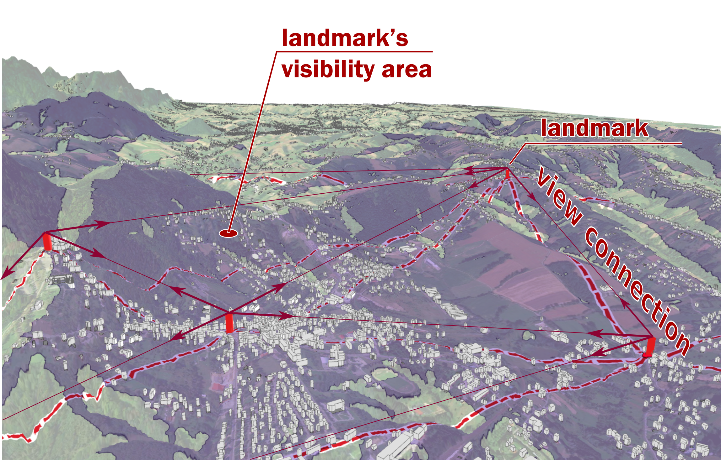
2.1. Study Area
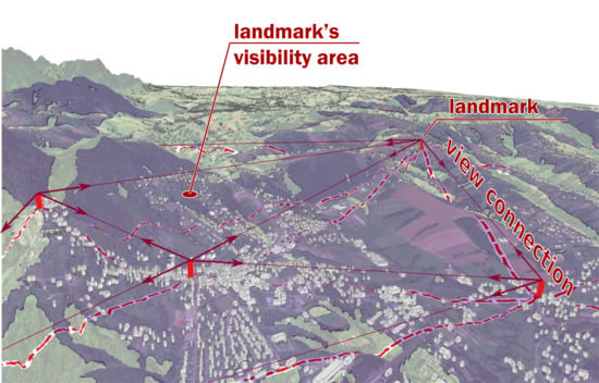
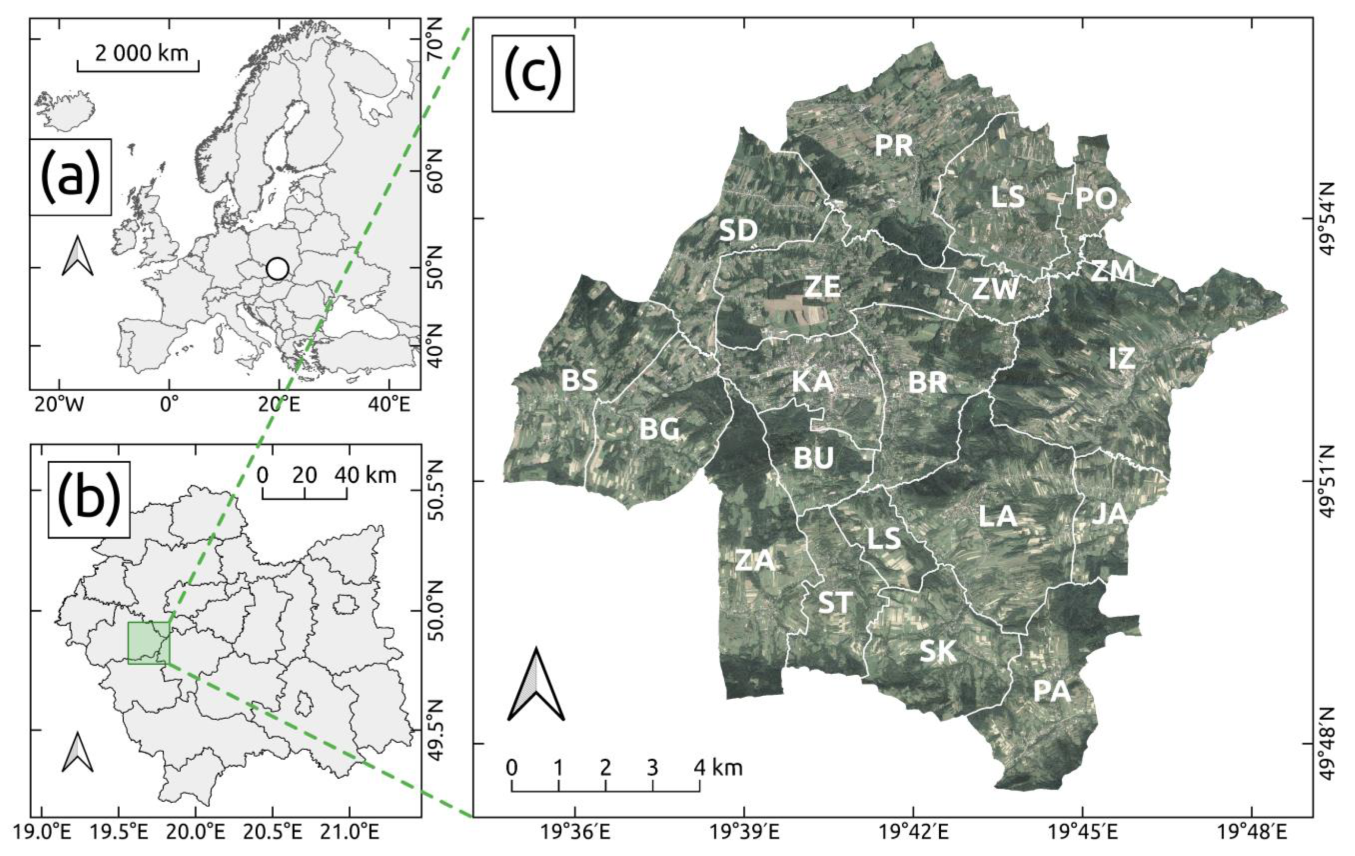
2.2. Data Processing
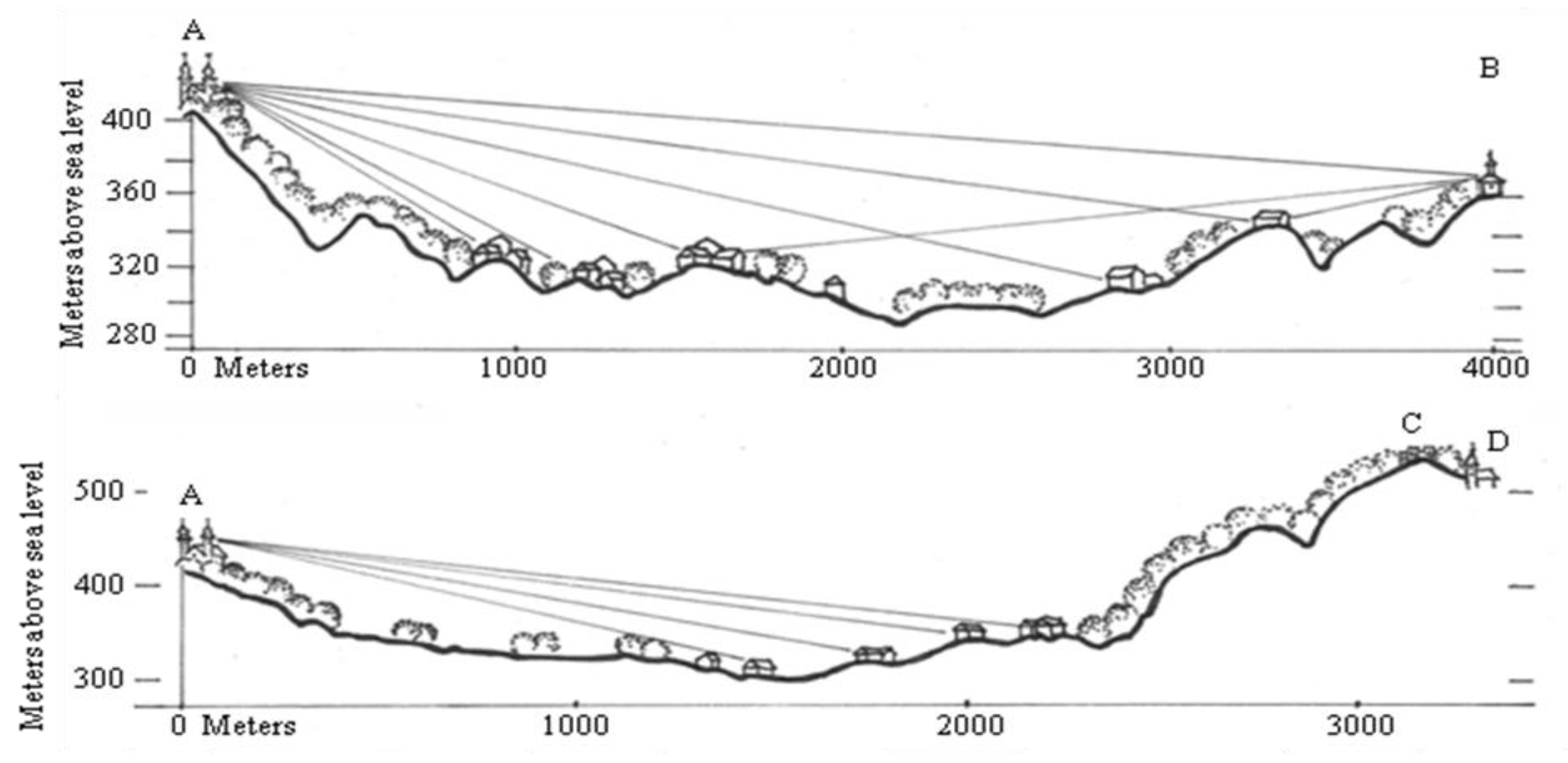
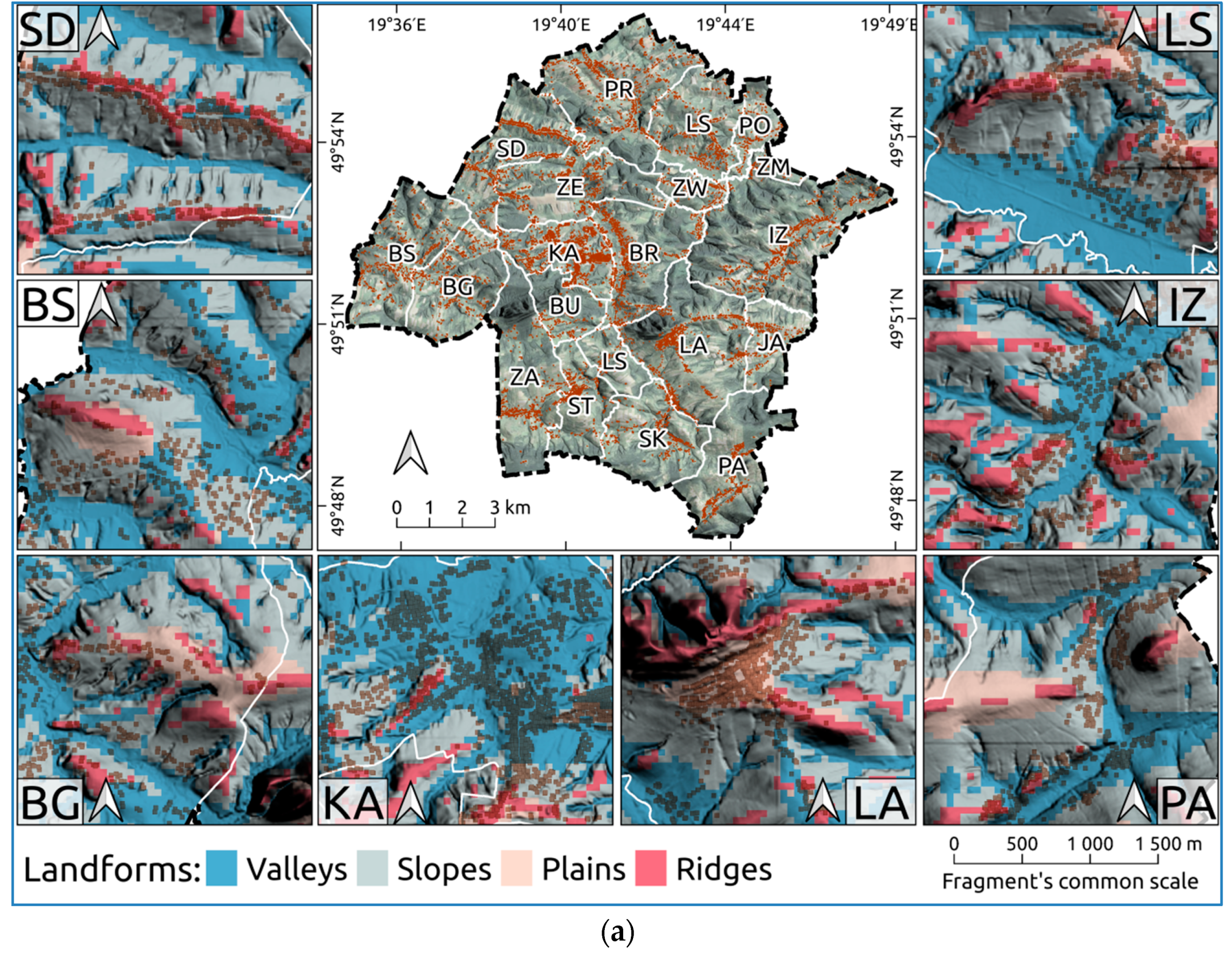
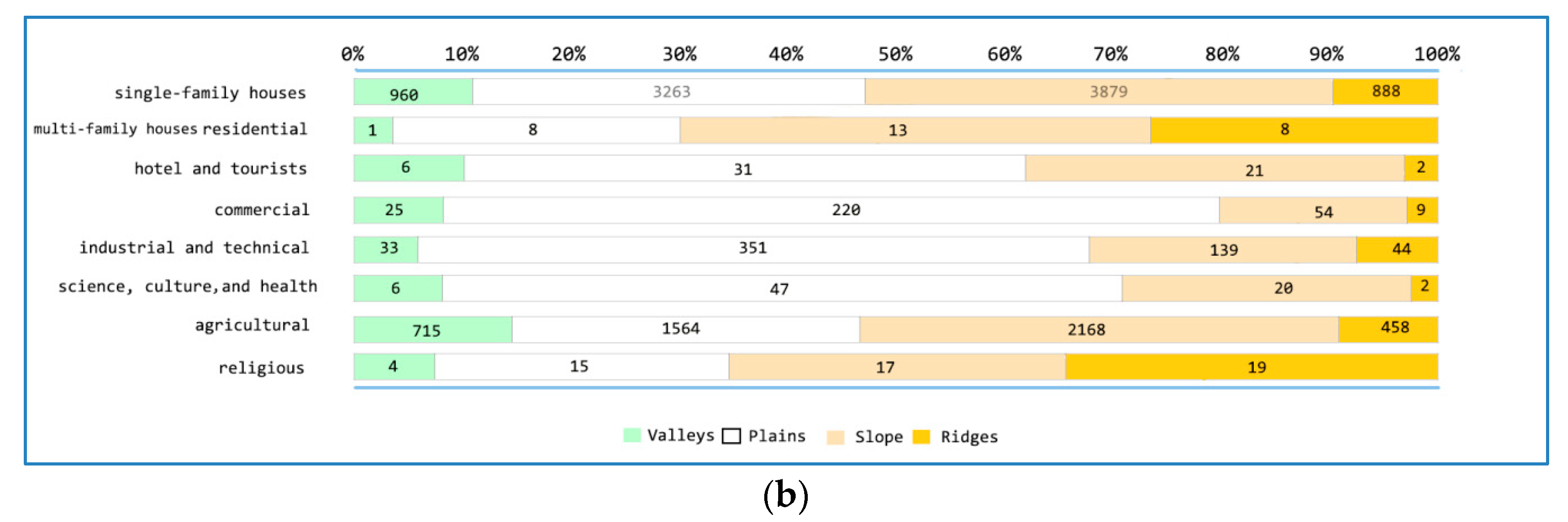
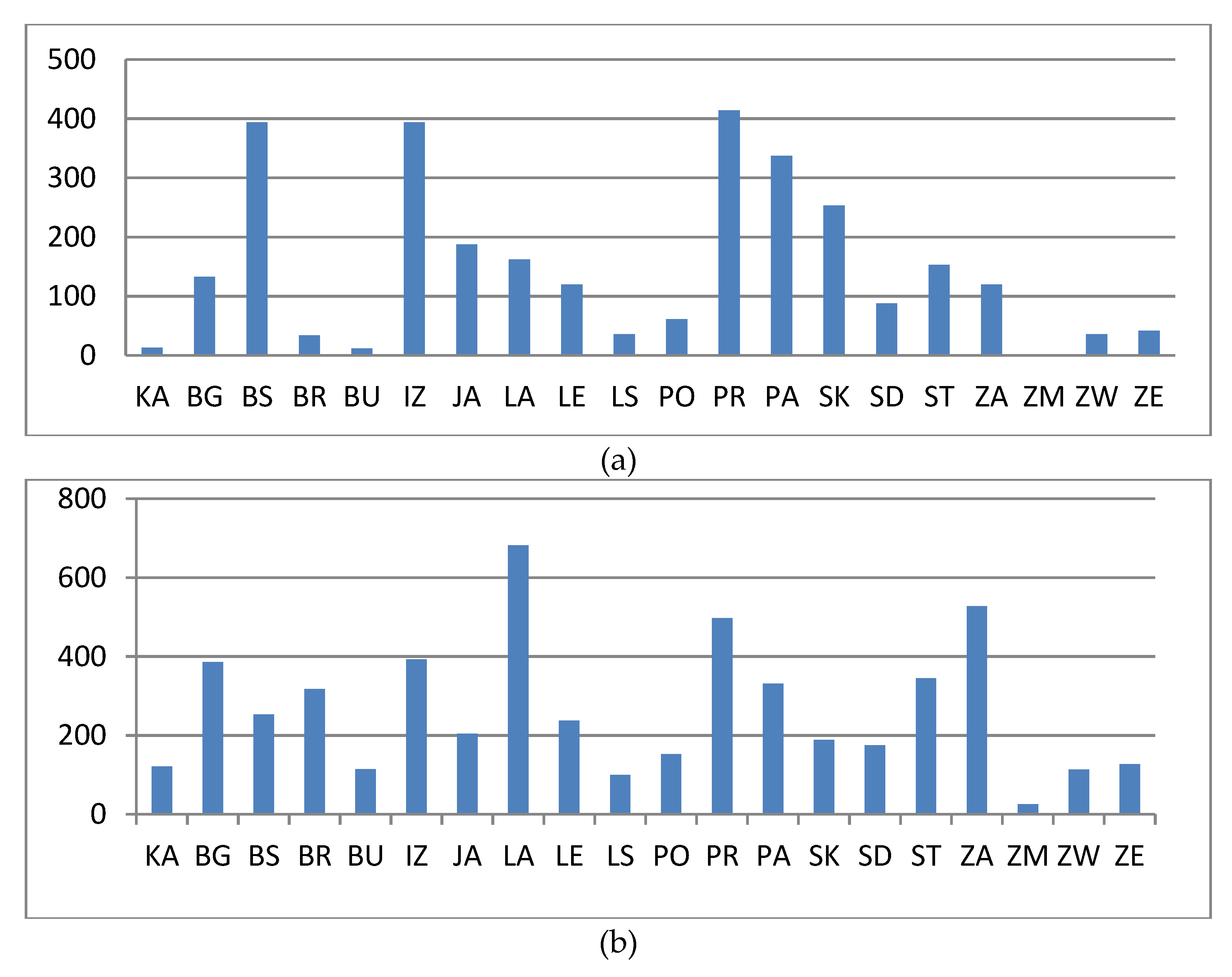
3. Results
4. Discussion
5. Conclusions
Author Contributions
Funding
Acknowledgments
Conflicts of Interest
Appendix A

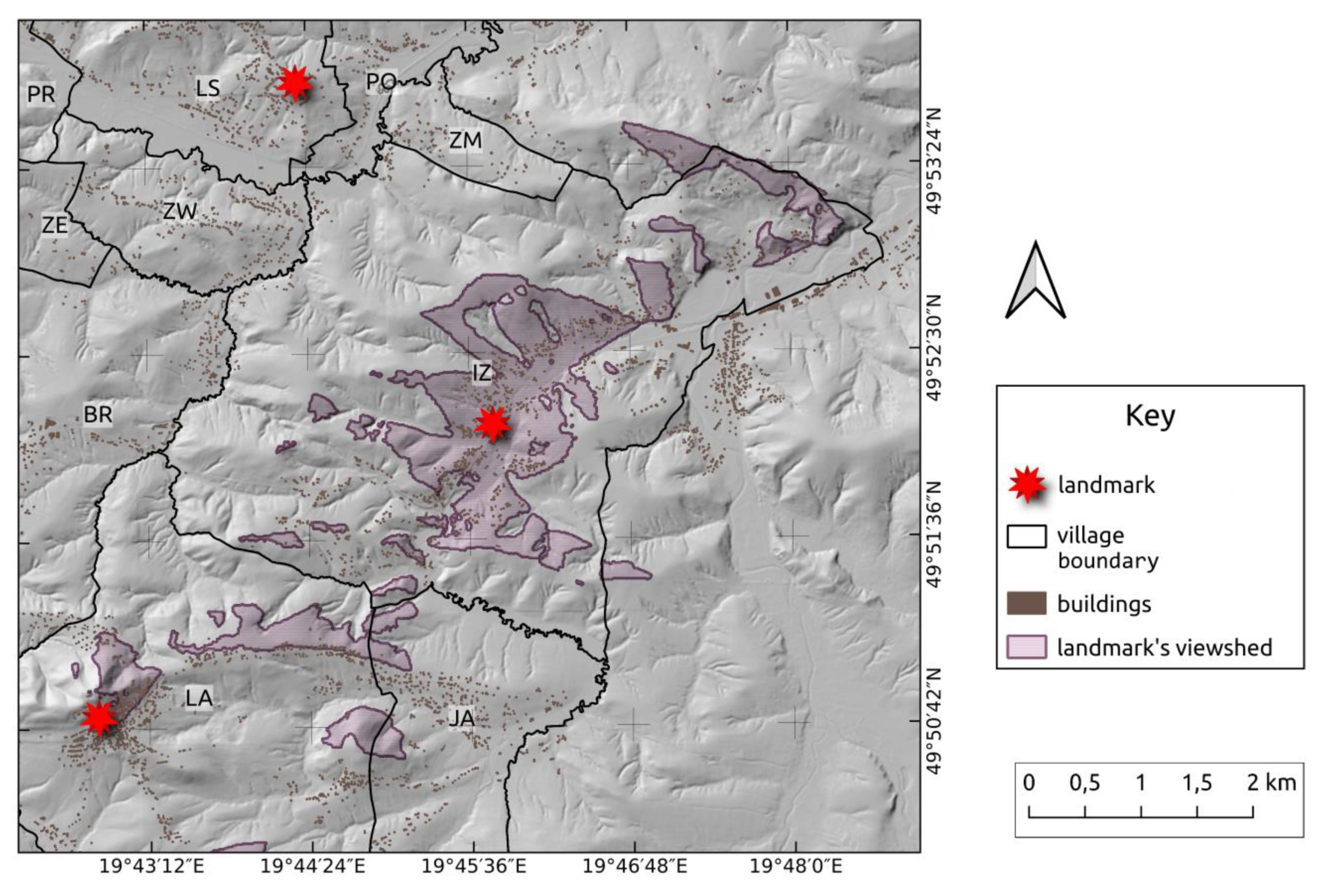
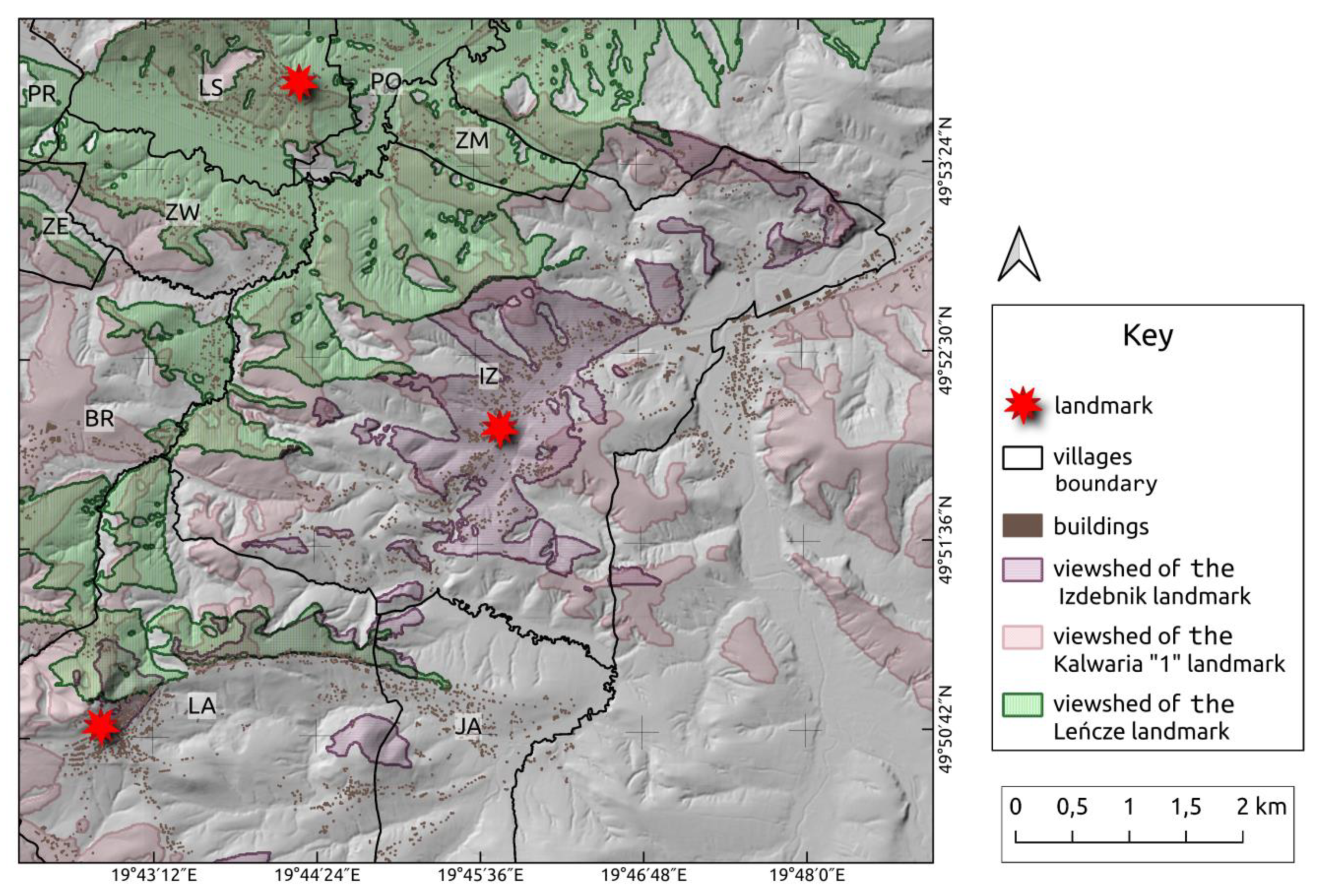
| No. | Object/Landmark Visibility Sketch | Characteristics of Selected Landmarks | Determined Area of the Range of Visibility [km2] within the Study Area |
|---|---|---|---|
| 1 |  | The Bernardine Shrine of Passion and Holy Mary in Kalwaria Zebrzydowska UNESCO list (1999); built between 1600 and 1617 Elevation incl. the tower: 405 + 35 = 440 m ASL | 45.981 |
| 2 |  | Lanckorona—a parish churchBuilt in 1649 Elevation incl. the tower: 488 + 30 = 518 m ASL | 20.486 |
| 3 |  | Izdebnik—a parish church Date of establishment: 1838–1841 Elevation incl. the tower: 270 + 22 = 292 m ASL | 5.333 |
| 4 |  | Brody—a parish church Date of establishment: 1615–1642 Elevation incl. the tower: 319 + 20 = 339 m ASL | 9.085 |
| 5 |  | Przytkowice—a parish church Date of establishment: 1948–1953 Elevation incl. the tower: 293 + 27 = 320 m ASL | 8.675 |
| 6 |  | Leńcze—a parish church Date of establishment: 1931–1938, Date of tower establishment: 1958–1959 Elevation incl. the tower: 325 + 27 = 352 m ASL | 14.739 |
| 7 |  | Skawinki—a parish church Date of establishment: 1733 (1962–1964) Elevation incl. the tower: 379 + 20 = 399 m ASL | 2.989 |
| 8 |  | Zebrzydowice—a parish church Built in 1620 Elevation incl. the tower: 281 + 20 = 301 m ASL | 12.615 |
| Buildings’ Functions | SFR | MFR | HTF | OF | CS | RST | GIW | SCH | AF | R | ONR | Total |
|---|---|---|---|---|---|---|---|---|---|---|---|---|
| KA | 1090 | 98 | 19 | 18 | 93 | 4 | 245 | 17 | 328 | 9 | 1 | 1922 |
| BG | 447 | 0 | 0 | 2 | 9 | 1 | 22 | 2 | 241 | 2 | 0 | 726 |
| BS | 436 | 0 | 0 | 1 | 4 | 0 | 30 | 2 | 318 | 0 | 1 | 792 |
| BR | 827 | 6 | 17 | 7 | 32 | 0 | 64 | 2 | 296 | 7 | 1 | 1259 |
| BU | 175 | 0 | 0 | 2 | 0 | 0 | 5 | 1 | 96 | 19 | 0 | 298 |
| IZ | 693 | 3 | 3 | 5 | 29 | 0 | 37 | 5 | 464 | 3 | 1 | 1243 |
| JA | 237 | 0 | 0 | 1 | 3 | 0 | 1 | 3 | 152 | 0 | 0 | 397 |
| LA | 770 | 4 | 12 | 9 | 5 | 0 | 17 | 8 | 433 | 4 | 1 | 1263 |
| LE | 469 | 3 | 0 | 2 | 8 | 1 | 8 | 4 | 243 | 2 | 0 | 740 |
| LS | 92 | 0 | 0 | 0 | 1 | 0 | 3 | 0 | 75 | 0 | 0 | 171 |
| PO | 135 | 0 | 0 | 0 | 2 | 0 | 0 | 1 | 101 | 0 | 0 | 239 |
| PR | 762 | 1 | 0 | 3 | 30 | 1 | 36 | 10 | 444 | 2 | 0 | 1289 |
| PA | 335 | 1 | 0 | 0 | 4 | 0 | 4 | 2 | 322 | 1 | 0 | 669 |
| SK | 314 | 1 | 0 | 1 | 1 | 0 | 3 | 1 | 234 | 1 | 0 | 556 |
| SD | 583 | 1 | 0 | 1 | 5 | 0 | 41 | 2 | 287 | 2 | 1 | 923 |
| ST | 338 | 1 | 0 | 2 | 3 | 0 | 3 | 6 | 177 | 0 | 0 | 530 |
| ZA | 379 | 3 | 5 | 1 | 6 | 1 | 12 | 4 | 297 | 1 | 0 | 709 |
| ZM | 49 | 0 | 0 | 0 | 0 | 0 | 0 | 1 | 31 | 0 | 0 | 81 |
| ZW | 182 | 0 | 2 | 1 | 2 | 0 | 1 | 1 | 92 | 0 | 0 | 281 |
| ZE | 580 | 5 | 2 | 2 | 4 | 0 | 34 | 3 | 268 | 2 | 0 | 900 |
| Total | 8990 | 127 | 60 | 58 | 241 | 8 | 566 | 75 | 4905 | 55 | 6 | 14,990 |
| Buildings’ Types | Valleys | Plains | Slopes | Ridges | ||||
|---|---|---|---|---|---|---|---|---|
| No | % | No | % | No | % | No | % | |
| SFR | 960 | 10.68 | 3263 | 36.30 | 3879 | 43.15 | 888 | 9.88 |
| MFR | 1 | 0.01 | 8 | 0.09 | 13 | 0.14 | 8 | 0.09 |
| HTF | 6 | 0.07 | 31 | 0.34 | 21 | 0.23 | 2 | 0.02 |
| CS | 25 | 0.28 | 220 | 2.45 | 54 | 0.60 | 9 | 0.10 |
| IT | 33 | 0.37 | 351 | 3.90 | 139 | 1.55 | 44 | 0.49 |
| SCH | 6 | 0.07 | 47 | 0.52 | 20 | 0.22 | 2 | 0.02 |
| AF | 715 | 7.95 | 1564 | 17.40 | 2168 | 24.12 | 458 | 5.09 |
| R | 4 | 0.04 | 15 | 0.17 | 17 | 0.19 | 19 | 0.21 |
References
- Nita, J. The importance of the determinants and discriminants in the landscape research. Diss. Cult. Landsc. Comm. 2015, 30, 59–70. [Google Scholar]
- Niedźwiedzka-Filipiak, I. Features of Landscape and Architecture of the Countryside of South-West Poland; Publishing House of University of Life Sciences: Wrocław, Poland, 2009; pp. 1–228. [Google Scholar]
- Fekete, A.; Van Den Toorn, M. Sacred Eye-Catchers, Urban Planning and Architecture Committee Book; Polska Akademia Nauk, Oddział w Krakowie, Politechnika Krakowka, Wydział Architektury (Polish Academy of Sciences, Cracow Branch, Cracow University of Technology, Faculty of Architecture): Kraków, Poland, 2018; Volume 46, pp. 303–311. [Google Scholar]
- Siewniak, M.; Mitkowska, A. Garden Art Thesaurus; Publishing House RYTM: Warsaw, Poland, 1998; pp. 59, 75. ISBN 83-87897-03-X. [Google Scholar]
- Dąbrowska-Budziłło, K. Symbolika w Kształtowaniu i Odnowie Krajobrazu, Czasopismo Techniczne, R104, z. 5-A; Politechnika Krakowska im. Tadeusza Kościuszki: Kraków, Poland, 2007; pp. 129–131. [Google Scholar]
- Mitkowska, A. Polskie Kalwarie; Publishing Zakład Narodowy im. Ossolińskich: Wrocław, Poland, 2003. [Google Scholar]
- Bogdanowski, J. Landscape Architecture; Publishing House PWN: Warsaw-Kraków, Poland, 1981; pp. 14–150. [Google Scholar]
- Plit, J.; Plit, F. Landscape dominants—The symbols of the authority in contemporary Poland. Diss. Cult. Landsc. Comm. 2017, 35, 63–73. [Google Scholar]
- Ramos, I.L.; Bernardo, F.; Ribeiro, S.C.; Van Eetvelde, V. Landscape identity: Implications for policy making. Land Use Policy 2016, 53, 36–43. [Google Scholar] [CrossRef]
- Dossche, R.; Rogge, E.; van Eetvelde, V. Detecting people’s and landscape’s identity in a changing mountain landscape. An example from the northern Apennines. Landsc. Res. 2016, 41, 934–949. [Google Scholar] [CrossRef]
- Raaphorst, K.; Duchhart, I.; van der Knaap, W.; Roeleveld, G.; van den Brink, A. The semiotics of landscape design communication: Towards a critical visual research approach in landscape architecture. Landsc. Res. 2017, 42, 120–133. [Google Scholar] [CrossRef]
- Szymańska, D. Geography of Settlements; Publishing House PWN: Warsaw, Poland, 2009. [Google Scholar]
- Sevenant, M.; Antrop, M. Settlement models, land use and visibility in rural landscapes: Two case studies in Greece. Landsc. Urban Plan. 2007, 80, 362–374. [Google Scholar] [CrossRef]
- Graczyk, R. The role of dominants in shaping space, selected aspects. Sci. J. Sil. Univ. Technol. Arch. 2004, 43, 61–66. [Google Scholar]
- Graczyk, R. Architectural dominant—A special sign and element of the composition of a small town. Sci. J. Sil. Univ. Technol. Arch. 2006, 44, 35–39. [Google Scholar]
- Banski, J.; Wesolowska, M. Transformations in housing construction in rural areas of Poland’s Lublin region-Influence on the spatial settlement structure and landscape aesthetics. Landsc. Urban Plan. 2010, 94, 116–126. [Google Scholar] [CrossRef]
- Bogdanowski, J. Historical Cultural Landscape and Problems of Its Protection. Monuments Protection 51/1 (200). 1998, pp. 4–13. Available online: http://bazhum.muzhp.pl/media//files/Ochrona_Zabytkow/Ochrona_Zabytkow-r1998-t51-n1_(200)/Ochrona_Zabytkow-r1998-t51-n1_(200)-s4-13/Ochrona_Zabytkow-r1998-t51-n1_(200)-s4-13.pdf (accessed on 10 January 2020).
- Prus, B. Landschaftsveränderungen von Kleinstädten in Polen von 1945 bis 1989 sowie nach der politischen Transformation von 1989 (Landscape changes of small towns in Poland from 1945 to 1989 and after the political transformation of 1989). In Transformation und Landschaft. Die Folgen Sozialer Wandlungsprozesse auf Landschaft; Kühne, O., Gawronski, K., Hernik, J., Eds.; Springer: Berlin, Germany, 2015; pp. 203–218. [Google Scholar]
- Prus, B.; Szylar, M. The analysis of settlement network’s dispersion using Ward’s taxonomy method. Surv. Rev. 2019, 51, 273–279. [Google Scholar] [CrossRef]
- Zhang, W.; Qi, J.; Wan, P.; Wang, H.; Xie, D.; Wang, X.; Yan, G. An easy-to-use airborne LiDAR data filtering method based on cloth simulation. Remote Sens. 2016, 8, 501. [Google Scholar] [CrossRef]
- Zevenbergen, L.W.; Thorne, Z. Quantitative analysis of land surface topography. Earth Surface Processes and Landforms. Br. Soc. Geomorphol. 1987, 12, 47–56. [Google Scholar] [CrossRef]
- Judex, M.; Thamm, H.P.; Menz, G. Improving land-cover classification with a knowledgebased approach and ancillary data. In Proceedings of the 2nd Workshop of the EARSeL SIG on Land Use and Land Cover, Center for Remote Sensing of Land Surfaces, Bonn, Germany, 28–30 September 2006. [Google Scholar]
- Deumlich, D.; Schmidt, R.; Sommer, M. A multiscale soil–landform relationship in the glacial-drift area based on digital terrain analysis and soil attributes. J. Plant Nutr. Soil Sci. 2010, 173, 843–851. [Google Scholar] [CrossRef]
- Bishop, I.D. Assessment of visual qualities, impacts, and behaviours, in the landscape, by using measures of visibility. Environ. Plan. B-Plan. Des. 2003, 30, 677–688. [Google Scholar] [CrossRef]
- Nutsford, D.; Reitsma, F.; Pearson, A.L.; Kingham, S. Personalising the viewshed: Visibility analysis from the human perspective. Appl. Geogr. 2015, 62, 1–7. [Google Scholar] [CrossRef]
- Antrop, M. Landscape change and the urbanization process in Europe. Landsc. Urban Plan. 2004, 67, 9–26. [Google Scholar] [CrossRef]
- Silva, K. The spirit of place of Bhaktapur, Nepal. Int. J. Herit. Stud. 2015, 21, 820–841. [Google Scholar] [CrossRef]
- Heathcott, J. Heritage in the dynamic city: The politics and practice of urban conservation on the swahili coast. Int. J. Urban Reg. Res. 2013, 37, 215–237. [Google Scholar] [CrossRef]
- Paquette, S.; Domon, G. Trends in rural landscape development and sociodemographic recomposition in southern Quebec (Canada). Landsc. Urban Plan. 2001, 55, 215–238. [Google Scholar] [CrossRef]
- Yiannakou, A.; Eppas, D.; Zeka, D. Spatial interactions between the settlement network, natural landscape and zones of economic activities: A case study in a Greek region. Sustainability 2017, 9, 1715. [Google Scholar] [CrossRef]
- Liu, J.G.; Dietz, T.; Carpenter, S.R.; Folke, C.; Alberti, M.; Redman, C.L.; Schneider, S.H.; Ostrom, E.; Pell, A.N.; Lubchenco, J.; et al. Coupled human and natural systems. Ambio 2007, 38, 639–649. [Google Scholar] [CrossRef]
- Feng, Z.M.; Yang, Y.Z.; Zhang, D.; Tang, Y. Natural environment suitability for human settlements in China based on GIS. J. Geogr. Sci. 2009, 19, 437–446. [Google Scholar] [CrossRef]
- Blondel, J. The ‘Design’ of Mediterranean landscapes: A millennial story of humans and ecological systems during the historic period. Hum. Ecol. 2006, 34, 713–729. [Google Scholar] [CrossRef]
- Steiner, F. Landscape ecological urbanism: Origins and trajectories. Landsc. Urban Plan. 2011, 100, 333–337. [Google Scholar] [CrossRef]
- Swensen, G. Between romantic historic landscapes, rational management models and obliterations - urban cemeteries as green memory sites. Urban For. Urban Green. 2018, 33, 58–65. [Google Scholar] [CrossRef]
- Poerwoningsih, D.; Antariksa; Leksono, A.S.; Hasyim, A.W. Integrating visibility analysis in rural spatial planning. Procedia Soc. Behav. Sci. 2016, 227, 838–844. [Google Scholar] [CrossRef]
- Hoyle, H.; Hitchmough, J.; Jorgensen, A. Attractive, climate-adapted and sustainable? Public perception of non-native planting in the designed urban landscape. Landsc. Urban Plan. 2017, 164, 49–63. [Google Scholar]
- Niedomysl, T. Towards a conceptual framework of place attractiveness: A migration perspective. Geogr. Ann. Ser. B Hum. Geogr. 2010, 92B, 97–109. [Google Scholar] [CrossRef]
- Niedźwiedzka-Filipiak, I. The distinguishing features of the cultural heritage of rural areas. Landsc. Arch. 2012, 2, 38–48. [Google Scholar]
- Pawłowska, K. The Idea of the Familiarity of the City; Publishing House of Cracow University of Technology: Kraków, Poland, 2001; ISBN 83-7242-201-X. [Google Scholar]
- Stobbelaar, D.J.; Pedroli, B. Perspectives on landscape identity: A conceptual challenge. Landsc. Res. 2001, 36, 321–339. [Google Scholar] [CrossRef]
- Mercado-Alonso, I.; Fern{ndez-Tabales, A.; Muñoz-Yules, O. Perceptions and social valuations of landscape. Objectives and methodology for citizen participation in landscape policies. Landsc. Res. 2018, 43, 95–111. [Google Scholar] [CrossRef]
- Antrop, M. Why landscapes of the past are important for the future. Landsc. Urban Plan. 2005, 70, 21–34. [Google Scholar] [CrossRef]
- Stephenson, J. The cultural values model: An integrated approach to values in landscapes. Landsc. Urban Plan. 2008, 84, 127–139. [Google Scholar] [CrossRef]
- Przyłęcki, M. Dominants in a landscape. Landsc. Arch. 2006, 1–2, 5–9. [Google Scholar]
- Gustin, S. Changing functions and identity of the Istrian rural landscape. Ann. Anali Istrske Mediter. Stud. Ser. Hist. Sociol. 2016, 26, 537–552. [Google Scholar]
- de Mezer, E. The consequences of changing the rank of old routes in the contemporary communication system on the example of the village of Raczkowo. In Polish Countryside Landscapes—Former and Contemporary; Zbigniew Kuriata; Komisja Krajobrazu Kulturowego Polskiego Towarzystwa Geograficznego: Sosnowiec, Poland, 2009; pp. 150–157. [Google Scholar]


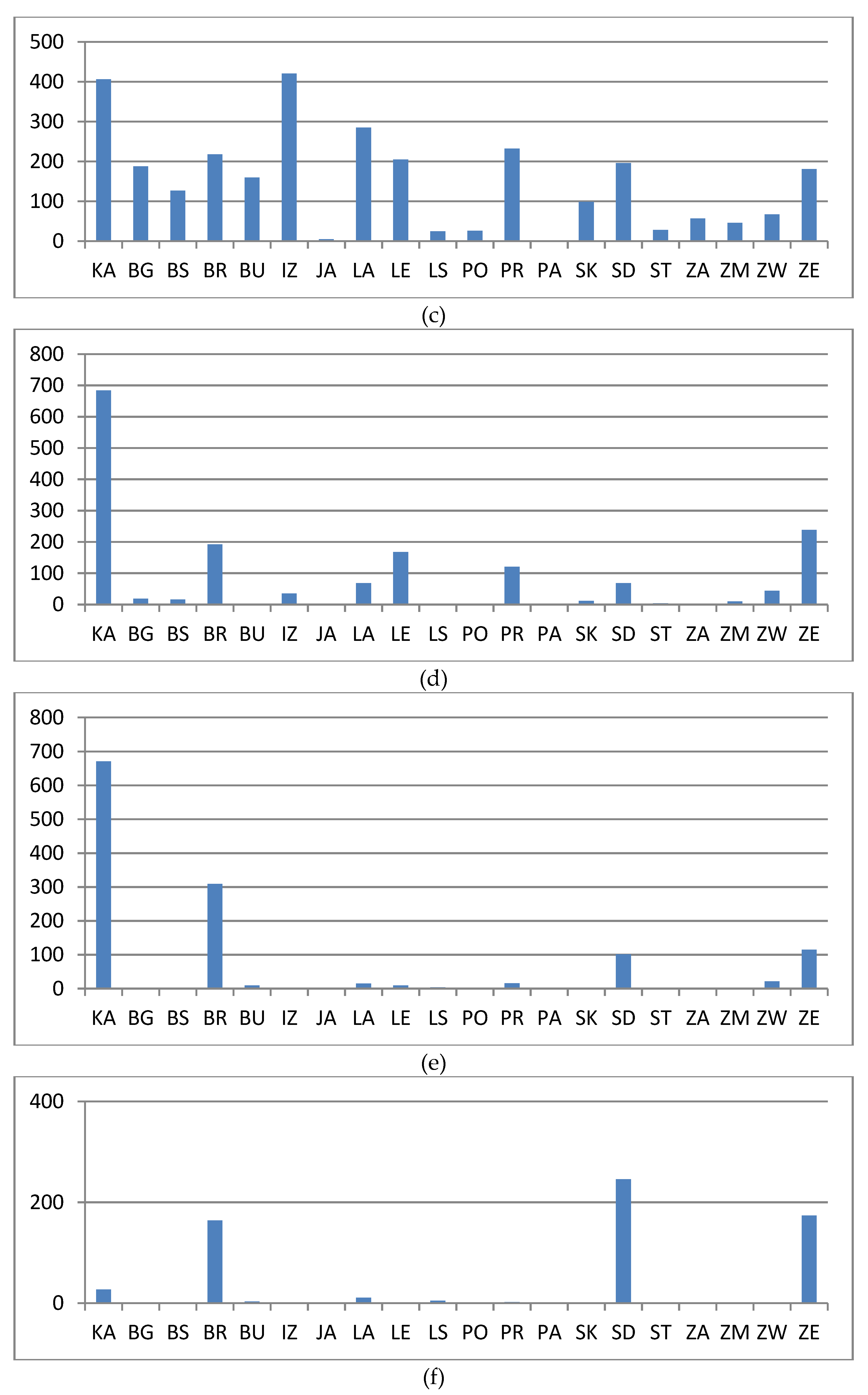
| Landmark Visibility | 0 | 1 | 2 | 3 | 4 | 5 | 6 | |||||||
|---|---|---|---|---|---|---|---|---|---|---|---|---|---|---|
| No | % | No | % | No | % | No | % | No | % | No | % | No | % | |
| KA | 13 | 0.7 | 121 | 6.3 | 406 | 21.1 | 684 | 35.6 | 671 | 34.9 | 27 | 1.4 | 0 | 0.0 |
| BG | 133 | 18.3 | 386 | 53.2 | 188 | 25.9 | 19 | 2.6 | 0 | 0.0 | 0 | 0.0 | 0 | 0.0 |
| BS | 394 | 49.7 | 253 | 31.9 | 127 | 16.0 | 16 | 2.0 | 2 | 0.3 | 0 | 0.0 | 0 | 0.0 |
| BR | 34 | 2.7 | 318 | 25.3 | 218 | 17.3 | 192 | 15.3 | 309 | 24.5 | 164 | 13.0 | 24 | 1.9 |
| BU | 12 | 4.0 | 114 | 38.3 | 160 | 53.7 | 0 | 0.0 | 9 | 3.0 | 3 | 1.0 | 0 | 0.0 |
| IZ | 394 | 31.7 | 393 | 31.6 | 421 | 33.9 | 35 | 2.8 | 0 | 0.0 | 0 | 0.0 | 0 | 0.0 |
| JA | 188 | 47.4 | 204 | 51.4 | 5 | 1.3 | 0 | 0.0 | 0 | 0.0 | 0 | 0.0 | 0 | 0.0 |
| LA | 162 | 12.8 | 682 | 54.0 | 285 | 22.6 | 68 | 5.4 | 15 | 1.2 | 11 | 0.9 | 28 | 2.2 |
| LE | 120 | 16.2 | 237 | 32.0 | 205 | 27.7 | 168 | 22.7 | 9 | 1.2 | 1 | 0.1 | 0 | 0.0 |
| LS | 36 | 21.1 | 100 | 58.5 | 25 | 14.6 | 1 | 0.6 | 4 | 2.3 | 5 | 2.9 | 0 | 0.0 |
| PO | 61 | 25.5 | 152 | 63.6 | 26 | 10.9 | 0 | 0.0 | 0 | 0.0 | 0 | 0.0 | 0 | 0.0 |
| PR | 414 | 32.1 | 497 | 38.6 | 232 | 18.0 | 121 | 9.4 | 16 | 1.2 | 2 | 0.2 | 7 | 0.5 |
| PA | 337 | 50.4 | 331 | 49.5 | 1 | 0.1 | 0 | 0.0 | 0 | 0.0 | 0 | 0.0 | 0 | 0.0 |
| SK | 253 | 45.5 | 189 | 34.0 | 99 | 17.8 | 12 | 2.2 | 3 | 0.5 | 0 | 0.0 | 0 | 0.0 |
| SD | 88 | 9.5 | 175 | 19.0 | 196 | 21.2 | 68 | 7.4 | 101 | 10.9 | 246 | 26.7 | 49 | 5.3 |
| ST | 153 | 28.9 | 345 | 65.1 | 28 | 5.3 | 4 | 0.8 | 0 | 0.0 | 0 | 0.0 | 0 | 0.0 |
| ZA | 120 | 16.9 | 528 | 74.5 | 57 | 8.0 | 1 | 0.1 | 3 | 0.4 | 0 | 0.0 | 0 | 0.0 |
| ZM | 0 | 0.0 | 25 | 30.9 | 46 | 56.8 | 10 | 12.3 | 0 | 0.0 | 0 | 0.0 | 0 | 0.0 |
| ZW | 36 | 12.8 | 113 | 40.2 | 67 | 23.8 | 44 | 15.7 | 21 | 7.5 | 0 | 0.0 | 0 | 0.0 |
| ZE | 42 | 4.7 | 127 | 14.1 | 181 | 20.1 | 238 | 26.4 | 115 | 12.8 | 174 | 19.3 | 23 | 2.6 |
| Total | 2990 | 19.9 | 5290 | 35.3 | 2973 | 19.8 | 1681 | 11.2 | 1278 | 8.5 | 633 | 4.2 | 131 | 0.9 |
© 2020 by the authors. Licensee MDPI, Basel, Switzerland. This article is an open access article distributed under the terms and conditions of the Creative Commons Attribution (CC BY) license (http://creativecommons.org/licenses/by/4.0/).
Share and Cite
Prus, B.; Wilkosz-Mamcarczyk, M.; Salata, T. Landmarks as Cultural Heritage Assets Affecting the Distribution of Settlements in Rural Areas—An Analysis Based on LIDAR DTM, Digital Photographs, and Historical Maps. Remote Sens. 2020, 12, 1778. https://doi.org/10.3390/rs12111778
Prus B, Wilkosz-Mamcarczyk M, Salata T. Landmarks as Cultural Heritage Assets Affecting the Distribution of Settlements in Rural Areas—An Analysis Based on LIDAR DTM, Digital Photographs, and Historical Maps. Remote Sensing. 2020; 12(11):1778. https://doi.org/10.3390/rs12111778
Chicago/Turabian StylePrus, Barbara, Magdalena Wilkosz-Mamcarczyk, and Tomasz Salata. 2020. "Landmarks as Cultural Heritage Assets Affecting the Distribution of Settlements in Rural Areas—An Analysis Based on LIDAR DTM, Digital Photographs, and Historical Maps" Remote Sensing 12, no. 11: 1778. https://doi.org/10.3390/rs12111778
APA StylePrus, B., Wilkosz-Mamcarczyk, M., & Salata, T. (2020). Landmarks as Cultural Heritage Assets Affecting the Distribution of Settlements in Rural Areas—An Analysis Based on LIDAR DTM, Digital Photographs, and Historical Maps. Remote Sensing, 12(11), 1778. https://doi.org/10.3390/rs12111778