Satellite-Observed Soil Moisture as an Indicator of Wildfire Risk


Abstract
1. Introduction
2. Data and Methods
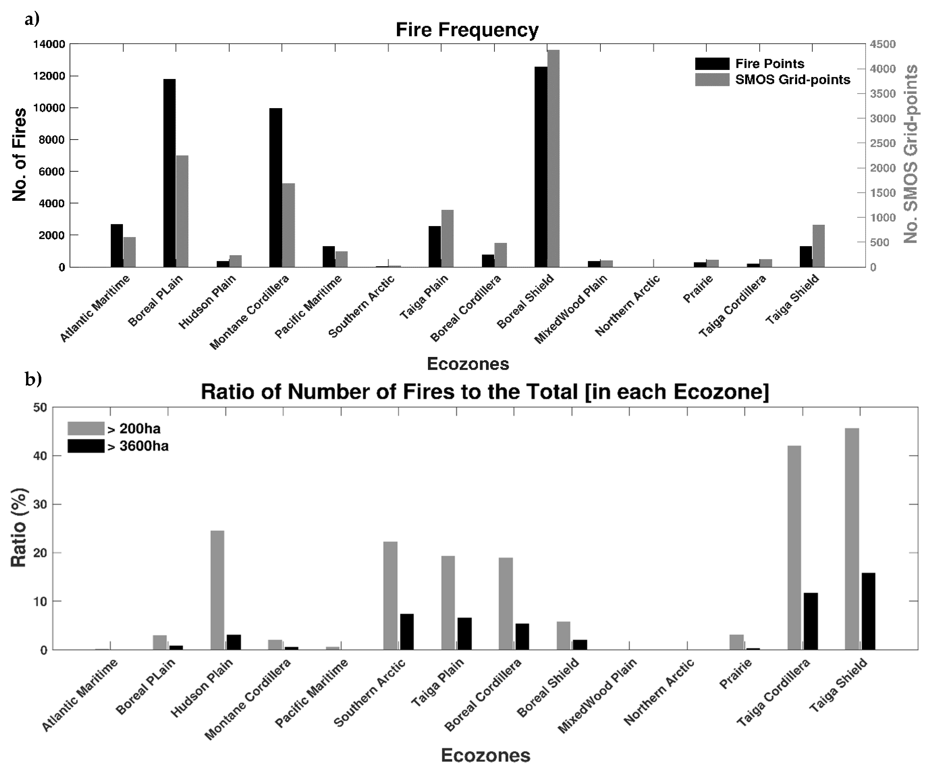
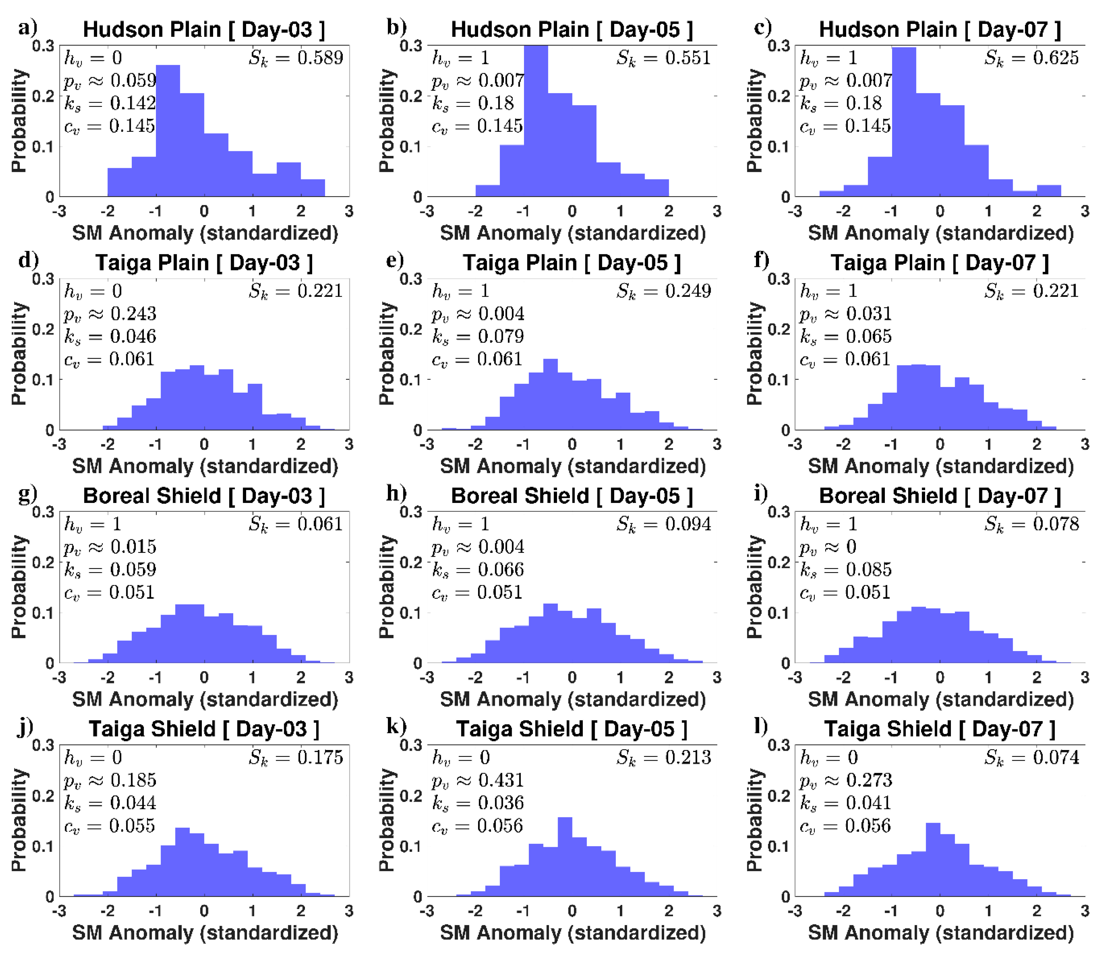
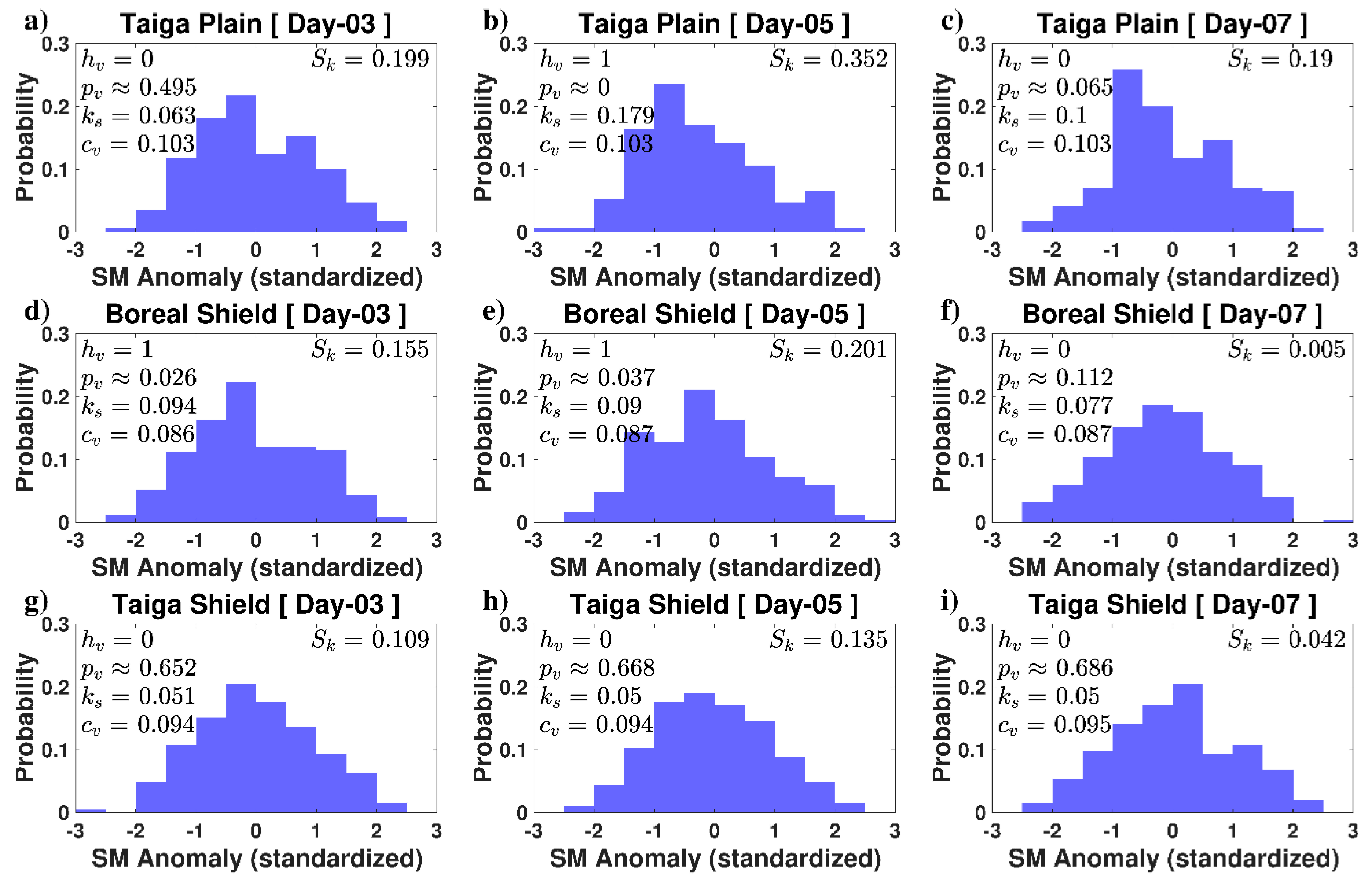
3. Results
4. Discussion
5. Conclusions
Author Contributions
Funding
Acknowledgments
Conflicts of Interest
References
- Krikken, F.; Lehner, F.; Drobyshev, I.; van Oldenborgh, G.J. Attribution of the role of global warming in the forest fires in Sweden 2018. In Geophysical Research Abstracts, Proceedings of the EGU General Assembly, Vienna, Austria, 7–12 April 2019; EGU2019-17342; EGU: Munich, Germany, 2019; Volume 21. [Google Scholar]
- Turco, M.; Rosa-Cánovas, J.J.; Bedia, J.; Jerez, S.; Montávez, J.P.; Llasat, M.-C.; Provenzale, A. Exacerbated fires in Mediterranean Europe due to anthropogenic warming projected with non-stationary climate-fire models. Nat. Commun. 2018, 9, 3821. [Google Scholar] [CrossRef]
- Gillett, N.P.; Weaver, A.J.; Zwiers, F.W.; Flannigan, M. Detecting the effect of climate change on Canadian forest fires. Geophys. Res. Lett. 2004, 31. [Google Scholar] [CrossRef]
- Flannigan, M.; Bergeron, Y.; Engelmark, O.; Wotton, B. Future wildfire in circumboreal forests in relation to global warming. J. Veg. Sci. 1998, 9, 469–476. [Google Scholar] [CrossRef]
- Keeley, J.; Syphard, A. Climate Change and Future Fire Regimes: Examples from California. Geoscience 2016, 6, 37. [Google Scholar] [CrossRef]
- Bolton, D.K.; Coops, N.C.; Wulder, M.A. Characterizing residual structure and forest recovery following high-severity fire in the western boreal of Canada using Landsat time-series and airborne lidar data. Remote. Sens. Environ. 2015, 163, 48–60. [Google Scholar] [CrossRef]
- Stocks, B.J.; Mason, J.A.; Todd, J.B.; Bosch, E.M.; Wotton, B.M.; Amiro, B.D.; Flannigan, M.D.; Hirsch, K.G.; Logan, K.A.; Martell, D.L.; et al. Large forest fires in Canada, 1959–1997. J. Geophys. Res. Atmos. 2002, 107, FFR-5. [Google Scholar] [CrossRef]
- Amiro, B.D.; Todd, J.B.; Wotton, B.M.; Logan, K.A.; Flannigan, M.D.; Stocks, B.J.; Mason, J.A.; Martell, D.L.; Hirsch, K.G. Direct carbon emissions from Canadian forest fires, 1959–1999. Can. J. For. Res. 2001, 31, 512–525. [Google Scholar] [CrossRef]
- Amiro, B.; Cantin, A.; Flannigan, M.; De Groot, W. Future emissions from Canadian boreal forest fires. Can. J. For. Res. 2009, 39, 383–395. [Google Scholar] [CrossRef]
- Alexander, M.E. Calculating and interpreting forest fire intensities. Can. J. Bot. 1982, 60, 349–357. [Google Scholar] [CrossRef]
- Flannigan, M.; Stocks, B.; Turetsky, M.; Wotton, M.; Flannigan, M. Impacts of climate change on fire activity and fire management in the circumboreal forest. Glob. Chang. Boil. 2009, 15, 549–560. [Google Scholar] [CrossRef]
- Wotton, B.M.; Nock, C.A.; Flannigan, M. Forest fire occurrence and climate change in Canada. Int. J. Wildland Fire 2010, 19, 253–271. [Google Scholar] [CrossRef]
- Stinson, G.; Kurz, W.A.; Smyth, C.E.; Neilson, E.T.; Dymond, C.C.; Metsaranta, J.M.; Boisvenue, C.; Rampley, G.J.; Li, Q.; White, T.M.; et al. An inventory-based analysis of Canada’s managed forest carbon dynamics, 1990 to 2008. Glob. Chang. Biol. 2011, 17, 2227–2244. [Google Scholar] [CrossRef]
- Chowdhury, E.H.; Hassan, Q.K. Development of a New Daily-Scale Forest Fire Danger Forecasting System Using Remote Sensing Data. Remote. Sens. 2015, 7, 2431–2448. [Google Scholar] [CrossRef]
- LeBlon, B. Monitoring Forest Fire Danger with Remote Sensing. Nat. Hazards 2005, 35, 343–359. [Google Scholar] [CrossRef]
- Lin, H.; Liu, Z.; Zhao, T.; Zhang, Y. Early Warning System of Forest Fire Detection Based on Video Technology. In Proceedings of the Lecture Notes in Electrical Engineering; Liu, X.Z., Ye, Y.Y., Eds.; Springer: Heidelberg/Berlin, Germany, 2013; Volume 272, pp. 751–758. [Google Scholar]
- Leckie, D.G. Advances in remote sensing technologies for forest surveys and management. Can. J. For. Res. 1990, 20, 464–483. [Google Scholar] [CrossRef]
- Chisholm, R.A.; Cui, J.; Lum, S.K.Y.; Chen, B.M. UAV LiDAR for below-canopy forest surveys. J. Unmanned Veh. Syst. 2013, 1, 61–68. [Google Scholar] [CrossRef]
- Den Breejen, E.; Breuers, M.; Cremer, F.; Kemp, R.; Roos, M.; Schutte, K.; De Vries, J.S. Autonomous forest fire detection. In Proceedings of the 3rd International Conference on Forest Fire Research, Luso, Portugal, 16–20 November 1998; pp. 2003–2012. [Google Scholar]
- Deeming, J.E.; Burgan, R.E.; Cohen, J.D. The National Fire-Danger Rating System—1978; Gen. Tech. Rep. INT-39; U.S. Department of Agriculture, Forest Service, Intermountain Forest and Range Experiment Station: Ogden, UT, USA, 1977; 63p.
- Chaparro, D.; Vall-llossera, M.; Piles, M. Chapter 11: A Review on European Remote Sensing Activities in Wildland Fires Prevention. In Remote Sensing of Hydrometeorological Hazards; CRC Press: Boca Raton, FL, USA, 2017; p. 237. [Google Scholar]
- Canadian Forest Service. Development and Structure of the Canadian Forest Fire Behaviour Prediction System; Information Report ST-X-3; Canadian Forest Service: Ottawa, ON, Canadian, 1992; 63p.
- Leblon, B.; Bourgeau-Chavez, L.; San-Miguel-Ayanz, J. Use of remote sensing in wildfire management (Chapter 3). In Sustainable Development—Authoritative and Leading Edge Content for Environmental Management; INTECH: Croatia, Rijeka, 2012; pp. 55–82. [Google Scholar]
- Dacamara, C.C.; Calado, T.J.; Ermida, S.L.; Trigo, I.F.; Amraoui, M.; Turkman, K.F. Calibration of the Fire Weather Index over Mediterranean Europe based on fire activity retrieved from MSG satellite imagery. Int. J. Wildland Fire 2014, 23, 945. [Google Scholar] [CrossRef]
- Hains, D.A.; Johnson, V.J.; Main, W.A. An Assessment of Three Measures of Long-Term Moisture Deficiency before Critical Fire Periods; Research Paper NC-131; North Central Forest Experiment Station, United States Department of Agriculture (USDA) Forest Service: St. Paul, MN, USA, 1976.
- Koster, R.; Suarez, M.J. Soil Moisture Memory in Climate Models. J. Hydrometeorol. 2001, 2, 558–570. [Google Scholar] [CrossRef]
- Seneviratne, S.I.; Koster, R.; Guo, Z.; Dirmeyer, P.A.; Kowalczyk, E.; Lawrence, D.; Liu, P.; Mocko, D.; Lu, C.-H.; Oleson, K.W.; et al. Soil Moisture Memory in AGCM Simulations: Analysis of Global Land–Atmosphere Coupling Experiment (GLACE) Data. J. Hydrometeorol. 2006, 7, 1090–1112. [Google Scholar] [CrossRef]
- Ambadan, J.T.; Berg, A.A.; Merryfield, W.J.; Lee, W.-S. Influence of snowmelt on soil moisture and on near surface air temperature during winter–spring transition season. Clim. Dyn. 2017, 51, 1295–1309. [Google Scholar] [CrossRef]
- Medler, M.J.; Montesano, P.; Robinson, D. Examining the Relationship between Snowfall and Wildfire Patterns in the Western United States. Phys. Geogr. 2002, 23, 335–342. [Google Scholar] [CrossRef]
- Westerling, A.L.; Hidalgo, H.G.; Cayan, D.R.; Swetnam, T.W. Warming and Earlier Spring Increase Western U.S. Forest Wildfire Activity. Science 2006, 313, 940–943. [Google Scholar] [CrossRef]
- Jia, S.; Kim, S.H.; Nghiem, S.; Kafatos, M.C. Estimating Live Fuel Moisture Using SMAP L-Band Radiometer Soil Moisture for Southern California, USA. Remote. Sens. 2019, 11, 1575. [Google Scholar] [CrossRef]
- Wang, L.; Quan, X.; He, B.; Yebra, M.; Xing, M.; Liu, X. Assessment of the Dual Polarimetric Sentinel-1A Data for Forest Fuel Moisture Content Estimation. Remote. Sens. 2019, 11, 1568. [Google Scholar] [CrossRef]
- Konings, A.G.; Piles, M.; Rötzer, K.; McColl, K.A.; Chan, S.K.; Entekhabi, D. Vegetation optical depth and scattering albedo retrieval using time series of dual-polarized L-band radiometer observations. Remote. Sens. Environ. 2016, 172, 178–189. [Google Scholar] [CrossRef]
- Konings, A.G.; Piles, M.; Das, N.; Entekhabi, D. L-band vegetation optical depth and effective scattering albedo estimation from SMAP. Remote. Sens. Environ. 2017, 198, 460–470. [Google Scholar] [CrossRef]
- Piles, M.; Sanchez, N.; Vall-Llossera, M.; Camps, A.; Martínez-Fernández, J.; Martinez, J.; Gonzalez-Gambau, V. A Downscaling Approach for SMOS Land Observations: Evaluation of High-Resolution Soil Moisture Maps over the Iberian Peninsula. IEEE J. Sel. Top. Appl. Earth Obs. Remote. Sens. 2014, 7, 3845–3857. [Google Scholar] [CrossRef]
- Naeimi, V.; Scipal, K.; Bartalis, Z.; Hasenauer, S.; Wagner, W. An Improved Soil Moisture Retrieval Algorithm for ERS and METOP Scatterometer Observations. IEEE Trans. Geosci. Remote. Sens. 2009, 47, 1999–2013. [Google Scholar] [CrossRef]
- Entekhabi, D.; Njoku, E.G.; O’Neill, P.E.; Kellogg, K.H.; Crow, W.T.; Edelstein, W.N.; Entin, J.K.; Goodman, S.D.; Jackson, T.J.; Johnson, J.; et al. The Soil Moisture Active Passive (SMAP) Mission. Proc. IEEE 2010, 98, 704–716. [Google Scholar] [CrossRef]
- Scaini, A.; Sanchez, N.; Vicente-Serrano, S.; Martínez-Fernández, J. SMOS-derived soil moisture anomalies and drought indices: A comparative analysis usingin situmeasurements. Hydrol. Process. 2014, 29, 373–383. [Google Scholar] [CrossRef]
- Martínez-Fernández, J.; González-Zamora, Á.; Sanchez, N.; Gumuzzio, A. A soil water based index as a suitable agricultural drought indicator. J. Hydrol. 2015, 522, 265–273. [Google Scholar] [CrossRef]
- Martínez-Fernández, J.; González-Zamora, Á.; Sánchez, N.; Gumuzzio, A.; Herrero-Jiménez, C. Satellite soil moisture for agricultural drought monitoring: Assessment of the SMOS derived Soil Water Deficit Index. Remote. Sens. Environ. 2016, 177, 277–286. [Google Scholar] [CrossRef]
- Sanchez, N.; González-Zamora, Á.; Piles, M.; Martínez-Fernández, J. A New Soil Moisture Agricultural Drought Index (SMADI) Integrating MODIS and SMOS Products: A Case of Study over the Iberian Peninsula. Remote. Sens. 2016, 8, 287. [Google Scholar] [CrossRef]
- Ross, M.A.; Ponce-Campos, G.E.; Barnes, M.L.; Hottenstein, J.D.; Moran, M.S. Response of grassland ecosystems to prolonged soil moisture deficit. In Proceedings of the EGU General Assembly Conference Abstracts, Vienna, Austria, 27 April–2 May 2014. [Google Scholar]
- White, J.; Berg, A.A.; Champagne, C.; Warland, J.; Zhang, Y. Canola yield sensitivity to climate indicators and passive microwave-derived soil moisture estimates in Saskatchewan, Canada. Agric. For. Meteorol. 2019, 268, 354–362. [Google Scholar] [CrossRef]
- Kerr, Y.H.; Richaume, P.; Wigneron, J.-P.; Gruhier, C.; Juglea, S.E.; Leroux, D.; Delwart, S.; Waldteufel, P.; Ferrazzoli, P.; Mahmoodi, A.; et al. The SMOS Soil Moisture Retrieval Algorithm. IEEE Trans. Geosci. Remote. Sens. 2012, 50, 1384–1403. [Google Scholar] [CrossRef]
- Kerr, Y.; Al-Yaari, A.; Rodríguez-Fernández, N.; Parrens, M.; Molero, B.; Leroux, D.; Bircher, S.; Mahmoodi, A.; Mialon, A.; Richaume, P.; et al. Overview of SMOS performance in terms of global soil moisture monitoring after six years in operation. Remote. Sens. Environ. 2016, 180, 40–63. [Google Scholar] [CrossRef]
- Forkel, M.; Thonicke, K.; Beer, C.; Cramer, W.; Bartalev, S.; Schmullius, C. Extreme fire events are related to previous-year surface moisture conditions in permafrost-underlain larch forests of Siberia. Environ. Res. Lett. 2012, 7, 044021. [Google Scholar] [CrossRef]
- Shvetsov, E. Fire Danger Estimation in Siberia Using SMOS Data. EGU General Assembly Conference Abstracts (Vol. 15). April 2013. Available online: http://neespi.org/web-content/meetings/EGU_2013/Shvetsov.pdf (accessed on 8 May 2020).
- Chaparro, D.; Vayreda, J.; Martínez-Vilalta, J.; Vall-Llossera, M.; Banque, M.; Camps, A.; Piles, M. SMOS and climate data applicability for analyzing forest decline and forest fires. In Proceedings of the 2014 IEEE Geoscience and Remote Sensing Symposium, Quebec City, QC, Canada, 13–18 July 2014; pp. 1069–1072. [Google Scholar] [CrossRef]
- Chaparro, D.; Piles, M.; Vall-Llossera, M. Remotely Sensed Soil Moisture as a Key Variable in Wildfires Prevention Services. In Satellite Soil Moisture Retrieval; Elsevier: Amsterdam, The Netherlands, 2016; pp. 249–269. [Google Scholar]
- Gherboudj, I.; Magagi, R.; Goita, K.; Berg, A.A.; Toth, B.; Walker, A. Validation of SMOS Data over Agricultural and Boreal Forest Areas in Canada. IEEE Trans. Geosci. Remote. Sens. 2012, 50, 1623–1635. [Google Scholar] [CrossRef]
- Magagi, R.; Berg, A.A.; Goita, K.; Belair, S.; Jackson, T.J.; Toth, B.; Walker, A.; McNairn, H.; O’Neill, P.E.; Moghaddam, M.; et al. Canadian Experiment for Soil Moisture in 2010 (CanEx-SM10): Overview and Preliminary Results. IEEE Trans. Geosci. Remote. Sens. 2012, 51, 347–363. [Google Scholar] [CrossRef]
- Adams, J.R.; McNairn, H.; Berg, A.A.; Champagne, C. Evaluation of near-surface soil moisture data from an AAFC monitoring network in Manitoba, Canada: Implications for L-band satellite validation. J. Hydrol. 2015, 521, 582–592. [Google Scholar] [CrossRef]
- McNairn, H.; Jackson, T.J.; Wiseman, G.; Bélair, S.; Berg, A.A.; Bullock, P.; Colliander, A.; Cosh, M.H.; Kim, S.; Magagi, R.; et al. The Soil Moisture Active Passive Validation Experiment 2012 (SMAPVEX12): Prelaunch Calibration and Validation of the SMAP Soil Moisture Algorithms. IEEE Trans. Geosci. Remote. Sens. 2014, 53, 2784–2801. [Google Scholar] [CrossRef]
- Djamai, N.; Magagi, R.; Goïta, K.; Hosseini, M.; Cosh, M.H.; Berg, A.A.; Toth, B. Evaluation of SMOS soil moisture products over the CanEx-SM10 area. J. Hydrol. 2015, 520, 254–267. [Google Scholar] [CrossRef]
- Champagne, C.; Rowlandson, T.; Berg, A.A.; Burns, T.; L’Heureux, J.; Tetlock, E.; Adams, J.R.; McNairn, H.; Toth, B.; Itenfisu, D. Satellite surface soil moisture from SMOS and Aquarius: Assessment for applications in agricultural landscapes. Int. J. Appl. Earth Obs. Geoinformation 2016, 45, 143–154. [Google Scholar] [CrossRef]
- Canadian Forest Service. National Fire Database–Agency Fire Data; Natural Resources Canada, Canadian Forest Service, Northern Forestry Centre: Edmonton, AB, Canada, 2018. Available online: http://cwfis.cfs.nrcan.gc.ca/ha/nfdb (accessed on 20 February 2020).
- Parisien, M.-A.; Peters, V.S.; Wang, Y.; Little, J.M.; Bosch, E.M.; Stocks, B.J. Spatial patterns of forest fires in Canada, 1980–1999. Int. J. Wildland Fire 2006, 15, 361–374. [Google Scholar] [CrossRef]
- Kerr, Y.H.; Waldteufel, P.; Wigneron, J.-P.; Delwart, S.; Cabot, F.; Boutin, J.; Escorihuela, M.J.; Font, J.; Reul, N.; Gruhier, C.; et al. The SMOS Mission: New Tool for Monitoring Key Elements ofthe Global Water Cycle. Proc. IEEE 2010, 98, 666–687. [Google Scholar] [CrossRef]
- Chan, S.K.; Bindlish, R.; O’Neill, P.E.; Njoku, E.; Jackson, T.; Colliander, A.; Chen, F.; Burgin, M.; Dunbar, S.; Piepmeier, J.; et al. Assessment of the SMAP Passive Soil Moisture Product. IEEE Trans. Geosci. Remote. Sens. 2016, 54, 4994–5007. [Google Scholar] [CrossRef]
- Chan, S.; Bindlish, R.; O’Neill, P.E.; Jackson, T.; Njoku, E.; Dunbar, S.; Chaubell, J.; Piepmeier, J.; Yueh, S.; Entekhabi, D.; et al. Development and assessment of the SMAP enhanced passive soil moisture product. Remote. Sens. Environ. 2018, 204, 931–941. [Google Scholar] [CrossRef]
- Pellarin, T.; Mialon, A.; Biron, R.; Coulaud, C.; Gibon, F.; Kerr, Y.; Lafaysse, M.; Mercier, B.; Morin, S.; Redor, I.; et al. Three years of L-band brightness temperature measurements in a mountainous area: Topography, vegetation and snowmelt issues. Remote. Sens. Environ. 2016, 180, 85–98. [Google Scholar] [CrossRef]
- Mialon, A.; Coret, L.; Kerr, Y.; Secherre, F.; Wigneron, J.-P. Flagging the Topographic Impact on the SMOS Signal. IEEE Trans. Geosci. Remote. Sens. 2008, 46, 689–694. [Google Scholar] [CrossRef]
- Marshall, I.B.; Schut, P.H.; Ballard, M. A National Ecological Framework for Canada: Attribute Data; Agriculture and Agri-Food Canada, Research Branch, Centre for Land and Biological Resources Research and Environment Canada, State of the Environment Directorate, Ecozone Analysis Branch: Ottawa, ON, Canada; Hull, QC, Canada, 1999. Available online: http://sis.agr.gc.ca/cansis/nsdb/ecostrat/1999report/index.html (accessed on 20 February 2020).
- Hanes, C.C.; Wang, X.; Jain, P.; Parisien, M.-A.; Little, J.M.; Flannigan, M.D. Fire-regime changes in Canada over the last half century. Can. J. For. Res. 2019, 49, 256–269. [Google Scholar] [CrossRef]
- Girardin, M.P.; Mudelsee, M. Past and future changes in Canadian boreal wildfire activity. Ecol. Appl. 2008, 18, 391–406. [Google Scholar] [CrossRef] [PubMed]
- Gedalof, Z. Climate and Spatial Patterns of Wildfire in North America. In The Landscape Ecology of Fire; McKenzie, D., Miller, C., Falk, D., Eds.; Springer: Dordrecht, The Netherlands, 2011; pp. 89–116. [Google Scholar]


© 2020 by the authors. Licensee MDPI, Basel, Switzerland. This article is an open access article distributed under the terms and conditions of the Creative Commons Attribution (CC BY) license (http://creativecommons.org/licenses/by/4.0/).
Share and Cite
Thomas Ambadan, J.; Oja, M.; Gedalof, Z.; Berg, A.A. Satellite-Observed Soil Moisture as an Indicator of Wildfire Risk. Remote Sens. 2020, 12, 1543. https://doi.org/10.3390/rs12101543
Thomas Ambadan J, Oja M, Gedalof Z, Berg AA. Satellite-Observed Soil Moisture as an Indicator of Wildfire Risk. Remote Sensing. 2020; 12(10):1543. https://doi.org/10.3390/rs12101543
Chicago/Turabian StyleThomas Ambadan, Jaison, Matilda Oja, Ze’ev Gedalof, and Aaron A. Berg. 2020. "Satellite-Observed Soil Moisture as an Indicator of Wildfire Risk" Remote Sensing 12, no. 10: 1543. https://doi.org/10.3390/rs12101543
APA StyleThomas Ambadan, J., Oja, M., Gedalof, Z., & Berg, A. A. (2020). Satellite-Observed Soil Moisture as an Indicator of Wildfire Risk. Remote Sensing, 12(10), 1543. https://doi.org/10.3390/rs12101543