Co-Segmentation and Superpixel-Based Graph Cuts for Building Change Detection from Bi-Temporal Digital Surface Models and Aerial Images

Abstract
1. Introduction
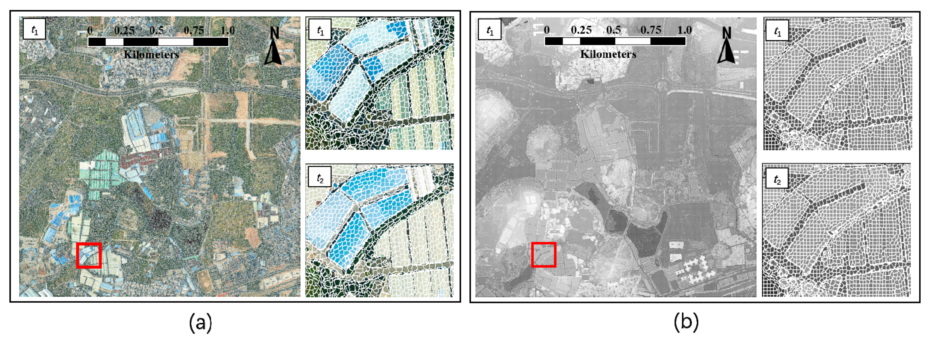
- A novel co-segmentation algorithm is proposed to jointly segment bi-temporal DSMs into bi-temporal superpixels. The superpixels are consistent with both periods of high-resolution remote sensing data. It can effectively avoid salt and pepper noise and minimize sliver objects caused by segmentation of each period of data independently.
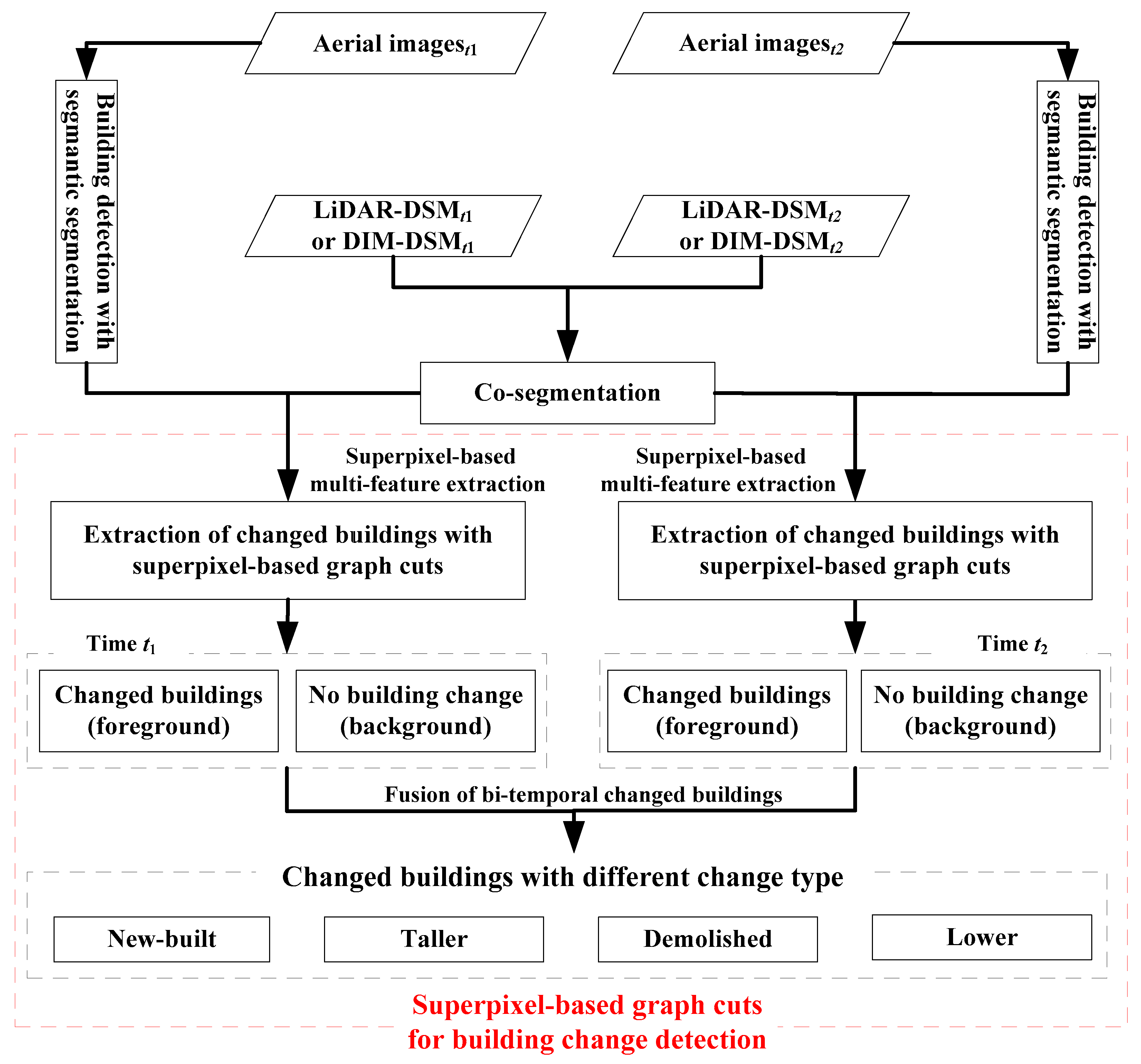
- An effective superpixel-graph-cuts-based building change detection framework is proposed to extract changed buildings with different change types, in which bi-temporal superpixels are taken as the processing unit, building change detection is converted into binary classifications, and the graph cuts algorithm is used to achieve a global optimal solution with three-dimensional information and CNN-based semantic segmentation as the superpixel features.
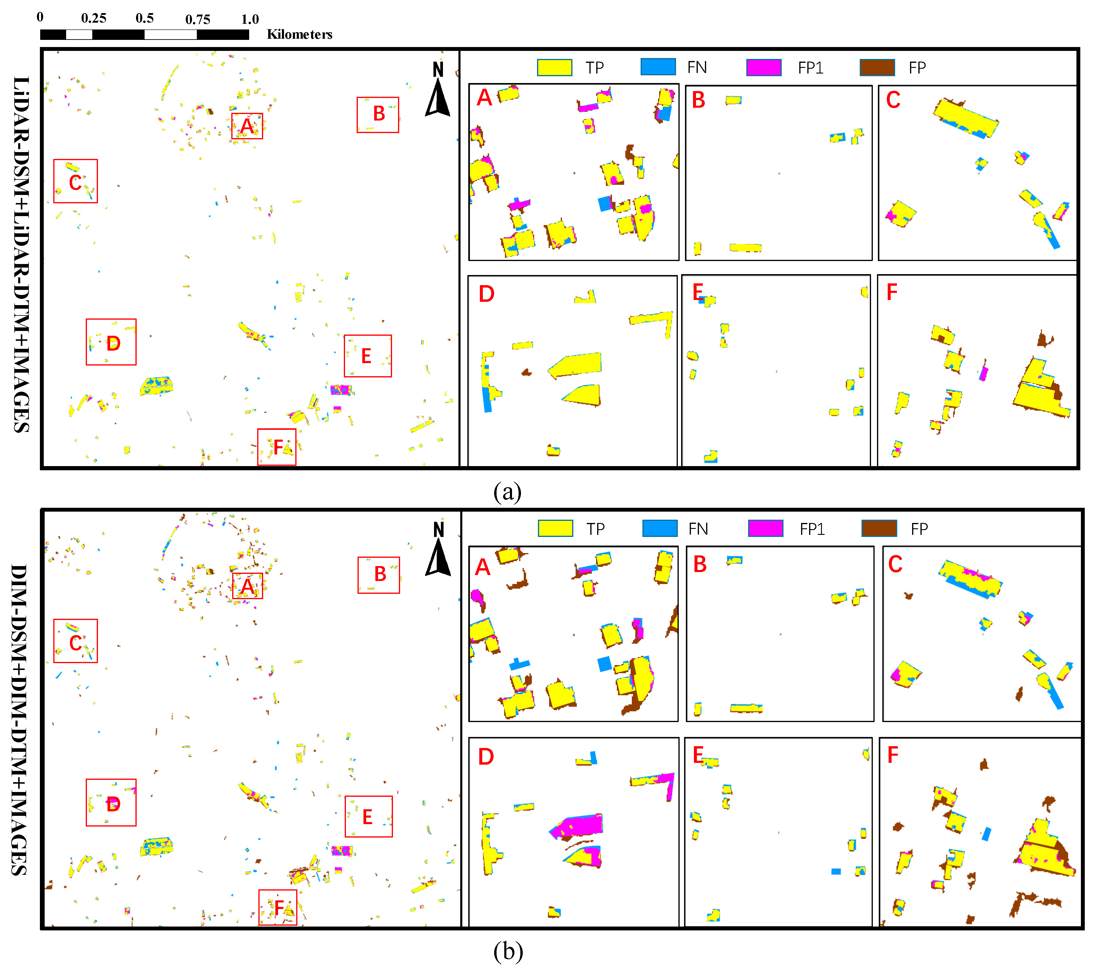
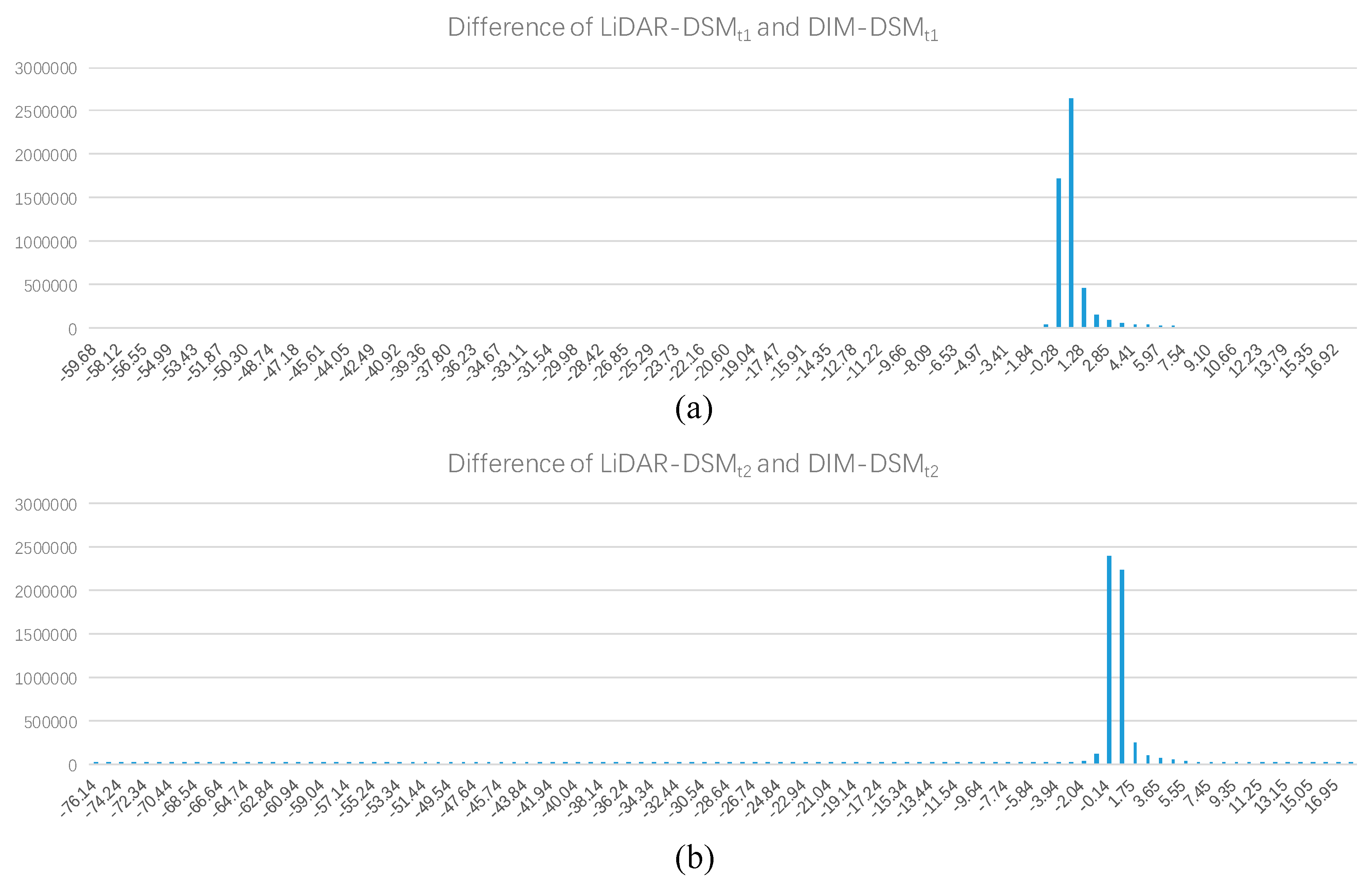
- The proposed framework is general and can be applied to point cloud data obtained by ALS and DIM. Different data sources (i.e., LiDAR-DSM and DIM-DSM) from the same region are used to validate the proposed method, which is of great significance to the selection of data sources in engineering practice.
2. Co-Segmentation and Superpixel-Based Graph Cuts for Building Change Detection
2.1. Co-Segmentation of Bi-Temporal DSMs
2.2. Building Detection with Semantic Segmentation
2.3. Superpixel-Based Graph Cuts for Building Change Detection
2.3.1. Overview of Our Superpixel-Based Graph Cuts
2.3.2. Extraction of the Changed Buildings with Superpixel-Based Graph Cuts
2.3.3. Fusion of Bi-Temporal Changed Buildings
3. Results
3.1. Description of Datasets
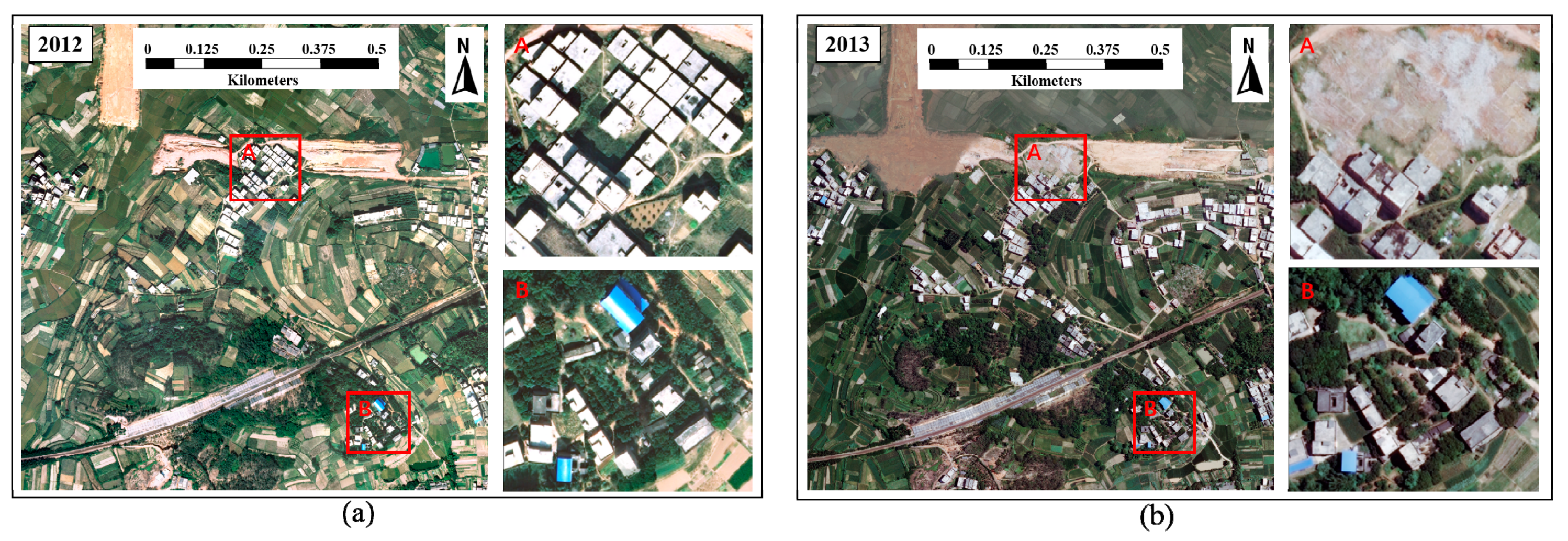
3.1.1. Dataset 1: Nanning
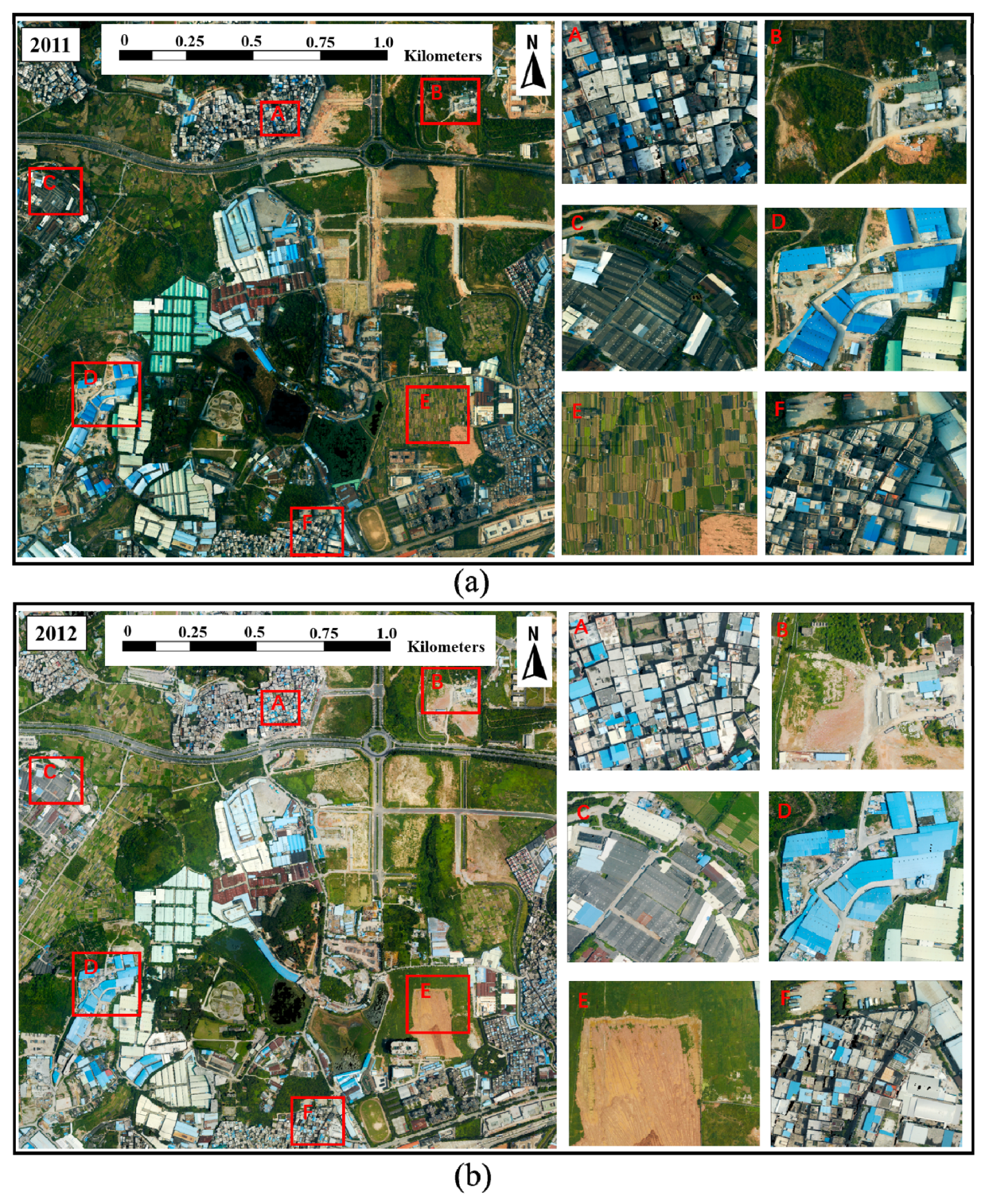
3.1.2. Dataset 2: Guangzhou
3.2. Accuracy Assessment Measures
3.3. Results and Evaluation
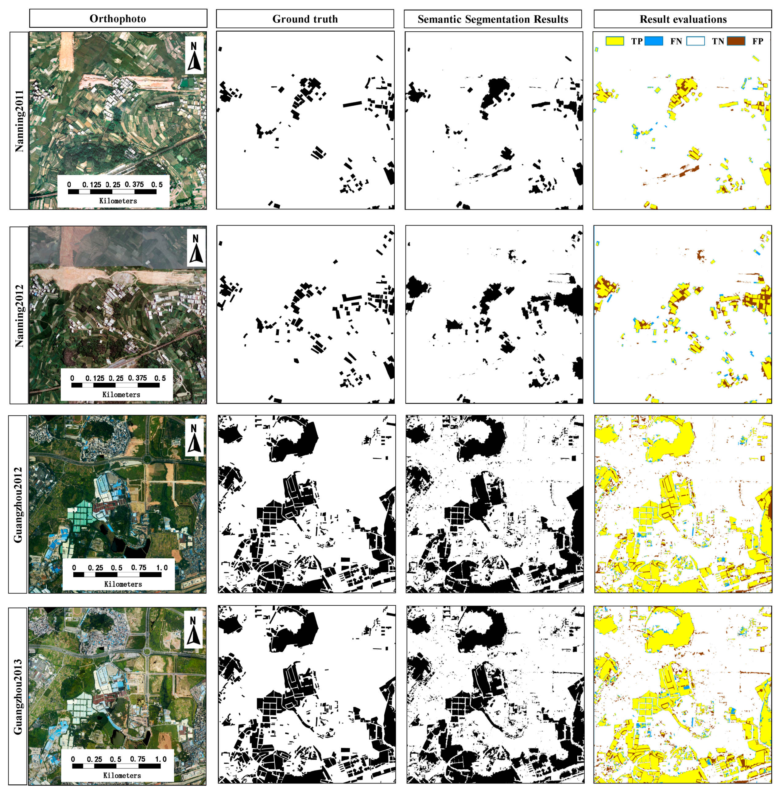
3.3.1. Evaluation of Semantic Segmentation
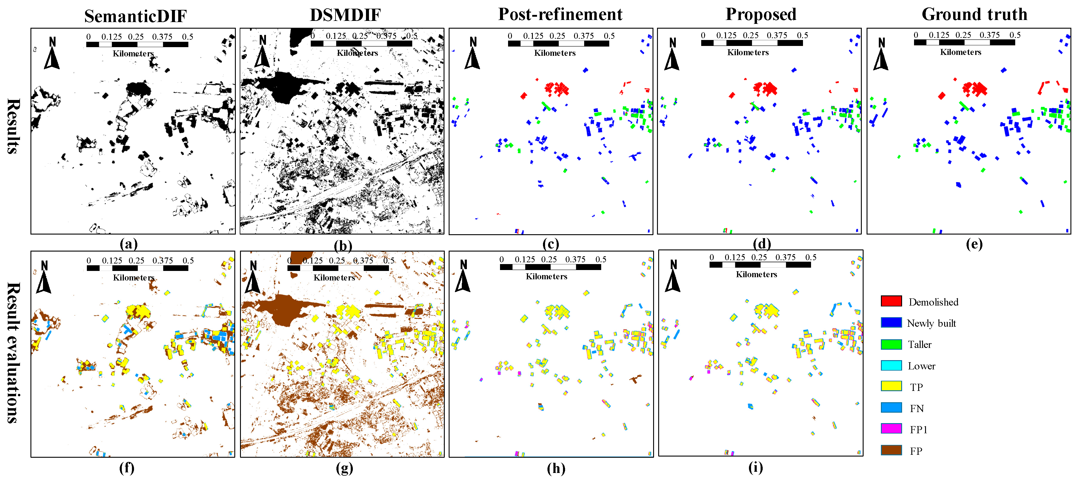
3.3.2. Evaluation of Building Change Detection
4. Discussion
4.1. Difference of LiDAR-DSM and Dense Image Matching Digital Surface Models (DIM-DSM)
4.2. Parameter Selection
5. Conclusions
Author Contributions
Funding
Acknowledgments
Conflicts of Interest
References
- Argialas, D.; Michailidou, S.; Tzotsos, A. Change detection of buildings in suburban areas from high resolution satellite data developed through object based image analysis. Surv. Rev. 2013, 45, 441–450. [Google Scholar] [CrossRef] [Scilit]
- Bouziani, M.; Goïta, K.; He, D.-C. Automatic change detection of buildings in urban environment from very high spatial resolution images using existing geodatabase and prior knowledge. ISPRS J. Photogramm. Remote Sens. 2010, 65, 143–153. [Google Scholar] [CrossRef] [Scilit]
- Huang, X.; Zhang, L.; Zhu, T. Building change detection from multitemporal high-resolution remotely sensed images based on a morphological building index. IEEE J. Sel. Top. Appl. Earth Obs. Remote Sens. 2014, 7, 105–115. [Google Scholar] [CrossRef] [Scilit]
- Li, P.; Xu, H.; Guo, J. Urban building damage detection from very high resolution imagery using ocsvm and spatial features. Int. J. Remote Sens. 2010, 31, 3393–3409. [Google Scholar] [CrossRef] [Scilit]
- Tang, Y.; Huang, X.; Zhang, L. Fault-tolerant building change detection from urban high-resolution remote sensing imagery. IEEE Geosci. Remote Sens. Lett. 2013, 10, 1060–1064. [Google Scholar] [CrossRef] [Scilit]
- Vu, T.T.; Ban, Y. Context-based mapping of damaged buildings from high-resolution optical satellite images. Int. J. Remote Sens. 2010, 31, 3411–3425. [Google Scholar] [CrossRef] [Scilit]
- Hou, B.; Wang, Y.; Liu, Q. A saliency guided semi-supervised building change detection method for high resolution remote sensing images. Sensors 2016, 16, 1377. [Google Scholar] [CrossRef] [Scilit]
- Sofina, N.; Ehlers, M. Building change detection using high resolution remotely sensed data and gis. IEEE J. Sel. Top. Appl. Earth Obs. Remote Sens. 2017, 9, 3430–3438. [Google Scholar] [CrossRef] [Scilit]
- Pang, S.; Hu, X.; Cai, Z.; Gong, J.; Zhang, M. Building change detection from bi-temporal dense-matching point clouds and aerial images. Sensors 2018, 18, 966. [Google Scholar] [CrossRef] [Scilit] [PubMed]
- Qin, R.; Tian, J.; Reinartz, P. 3d change detection—Approaches and applications. ISPRS J. Photogramm. Remote Sens. 2016, 122, 41–56. [Google Scholar] [CrossRef] [Scilit]
- Pang, S.; Hu, X.; Wang, Z.; Lu, Y. Object-based analysis of airborne lidar data for building change detection. Remote Sens. 2014, 6, 10733–10749. [Google Scholar] [CrossRef] [Scilit]
- Teo, T.-A.; Shih, T.-Y. Lidar-based change detection and change-type determination in urban areas. Int. J. Remote Sens. 2013, 34, 968–981. [Google Scholar] [CrossRef] [Scilit]
- Murakami, H.; Nakagawa, K.; Hasegawa, H.; Shibata, T.; Iwanami, E. Change detection of buildings using an airborne laser scanner. ISPRS J. Photogramm. Remote Sens. 1999, 54, 148–152. [Google Scholar] [CrossRef] [Scilit]
- Awrangjeb, M.; Gilani, S.; Siddiqui, F. An effective data-driven method for 3-d building roof reconstruction and robust change detection. Remote Sens. 2018, 10, 1512. [Google Scholar] [CrossRef] [Scilit]
- Qin, R.J. Change detection on lod 2 building models with very high resolution spaceborne stereo imagery. ISPRS J. Photogramm. Remote Sens. 2014, 96, 179–192. [Google Scholar] [CrossRef] [Scilit]
- Jung, F. Detecting building changes from multitemporal aerial stereopairs. ISPRS J. Photogramm. Remote Sens. 2004, 58, 187–201. [Google Scholar] [CrossRef] [Scilit]
- Tian, J.; Reinartz, P.; d’Angelo, P.; Ehlers, M. Region-based automatic building and forest change detection on cartosat-1 stereo imagery. ISPRS J. Photogramm. Remote Sens. 2013, 79, 226–239. [Google Scholar] [CrossRef] [Scilit]
- Tian, J.; Cui, S.; Reinartz, P. Building change detection based on satellite stereo imagery and digital surface models. IEEE Trans. Geosci. Remote Sens. 2014, 52, 406–417. [Google Scholar] [CrossRef] [Scilit]
- Tian, J.; Nielsen, A.A.; Reinartz, P. Building damage assessment after the earthquake in haiti using two post-event satellite stereo imagery and dsms. Int. J. Image Data Fusion 2013, 6, 155–169. [Google Scholar] [CrossRef] [Scilit]
- Tian, J.; Chaabouni-Chouayakh, H.; Reinartz, P. 3d Building Change Detection from High Resolution Spaceborne Stereo Imagery. In Proceedings of the International Workshop on Multi-Platform/Multi-Sensor Remote Sensing and Mapping, Xiamen, China, 10–12 January 2011; pp. 1–7. [Google Scholar]
- Wenzhuo, L.; Sun, K.; Li, D.; Bai, T.; Sui, H. A new approach to performing bundle adjustment for time series uav images 3d building change detection. Remote Sens. 2017, 9, 625. [Google Scholar]
- Qin, R. An object-based hierarchical method for change detection using unmanned aerial vehicle images. Remote Sens. 2014, 6, 7911–7932. [Google Scholar] [CrossRef] [Scilit]
- Du, S.; Zhang, Y.; Qin, R.; Yang, Z.; Zou, Z.; Tang, Y.; Fan, C. Building change detection using old aerial images and new lidar data. Remote Sens. 2016, 8, 1030. [Google Scholar] [CrossRef] [Scilit]
- Chen, B.; Chen, Z.; Deng, L.; Zhou, J.; Zhou, J. Building change detection with rgb-d map generated from uav images. Neurocomputing 2016, 208, 350–364. [Google Scholar] [CrossRef] [Scilit]
- Qin, R.; Tian, J.; Reinartz, P. Spatiotemporal inferences for use in building detection using series of very-high-resolution space-borne stereo images. Int. J. Remote Sens. 2016, 37, 3455–3476. [Google Scholar] [CrossRef] [Scilit]
- Qin, R.; Huang, X.; Gruen, A.; Schmitt, G. Object-based 3-d building change detection on multitemporal stereo images. IEEE J. Sel. Top. Appl. Earth Obs. Remote Sens. 2017, 8, 2125–2137. [Google Scholar] [CrossRef] [Scilit]
- Arozarena, A. Change detection of buildings from satellite imagery and lidar data. Int. J. Remote Sens. 2013, 34, 1652–1675. [Google Scholar]
- Tewkesbury, A.P.; Comber, A.J.; Tate, N.J.; Lamb, A.; Fisher, P.F. A critical synthesis of remotely sensed optical image change detection techniques. Remote Sens. Environ. 2015, 160, 1–14. [Google Scholar] [CrossRef] [Scilit]
- Achanta, R.; Shaji, A.; Smith, K.; Lucchi, A.; Fua, P.; Süsstrunk, S. Slic superpixels compared to state-of-the-art superpixel methods. IEEE Trans. Pattern Anal. Mach. Intell. 2012, 34, 2274–2282. [Google Scholar] [CrossRef] [Scilit]
- Beucher, S.; Mathmatique, C.D.M. The watershed transformation applied to image segmentation. Scanning Microsc. Suppl. 1991, 6, 299–314. [Google Scholar]
- Comaniciu, D.; Meer, P. Mean shift: A robust approach toward feature space analysis. IEEE Trans. Pattern Anal. Mach. Intell. 2002, 24, 603–619. [Google Scholar] [CrossRef] [Scilit]
- Zhang, M.; Hu, X.; Zhao, L.; Lv, Y.; Luo, M.; Pang, S. Learning dual multi-scale manifold ranking for semantic segmentation of high-resolution images. Remote Sens. 2017, 9, 500. [Google Scholar] [CrossRef] [Scilit]
- Boykov, Y. Interactive graph cuts for optimal boundary and region segmentation of objects in n-d images. ICCV 2001, 1, 105–112. [Google Scholar]
- Boykov, Y.; Kolmogorov, V. An experimental comparison of min-cut/max-flow algorithms for energy minimization in vision. IEEE Trans. Pattern Anal. Mach. Intell. 2004, 26, 1124–1137. [Google Scholar] [CrossRef] [Scilit] [PubMed]
- Axelsson, P. Dem generation from laser scanner data using adaptive tin models. Int. Arch. Photogramm. Remote Sens. 2000, 33, 110–117. [Google Scholar]
- Adams, R.; Bischof, L. Seeded region growing. IEEE Trans. Pattern Anal. Mach. Intell. 2002, 16, 641–647. [Google Scholar] [CrossRef] [Scilit]


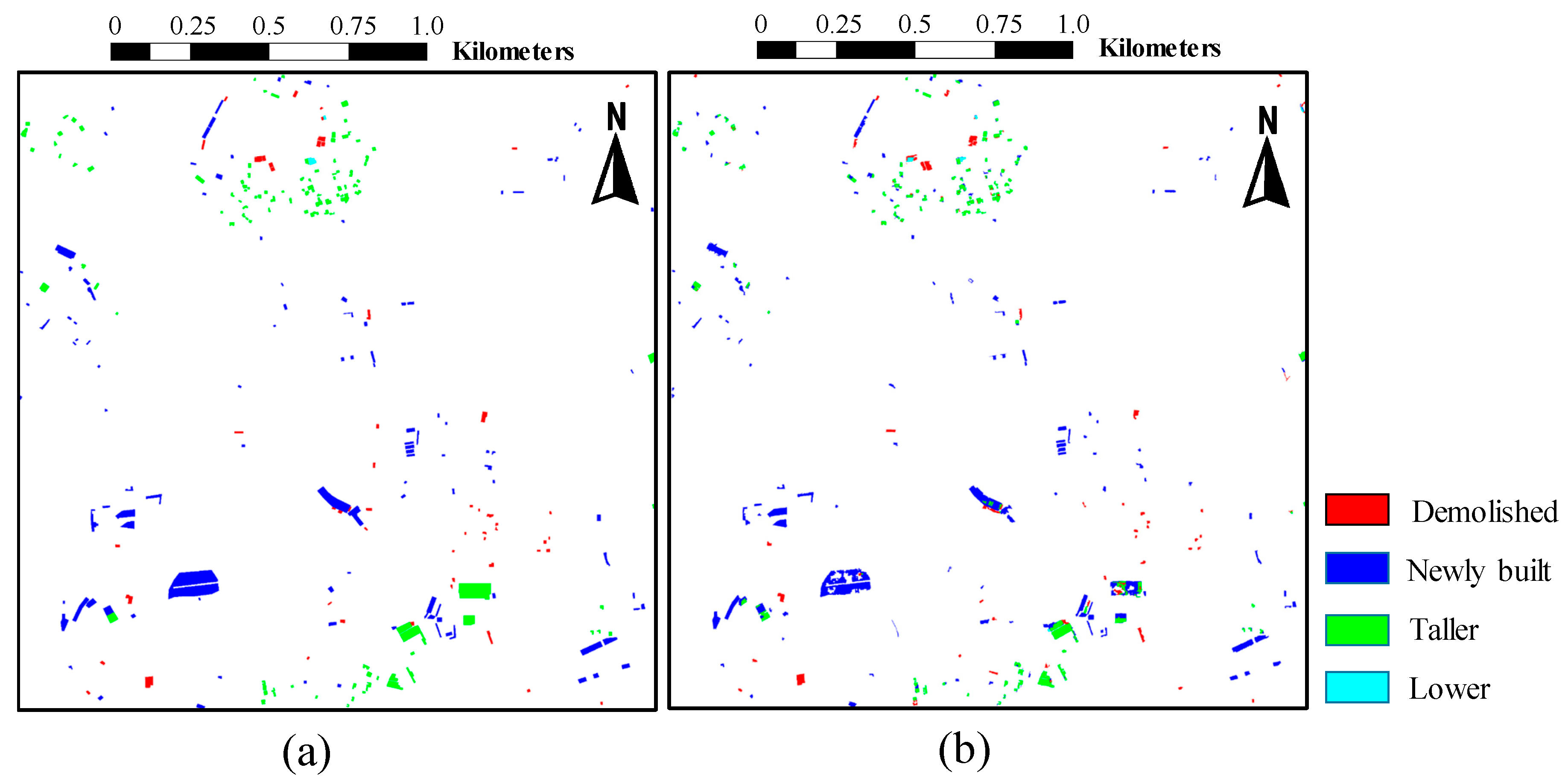

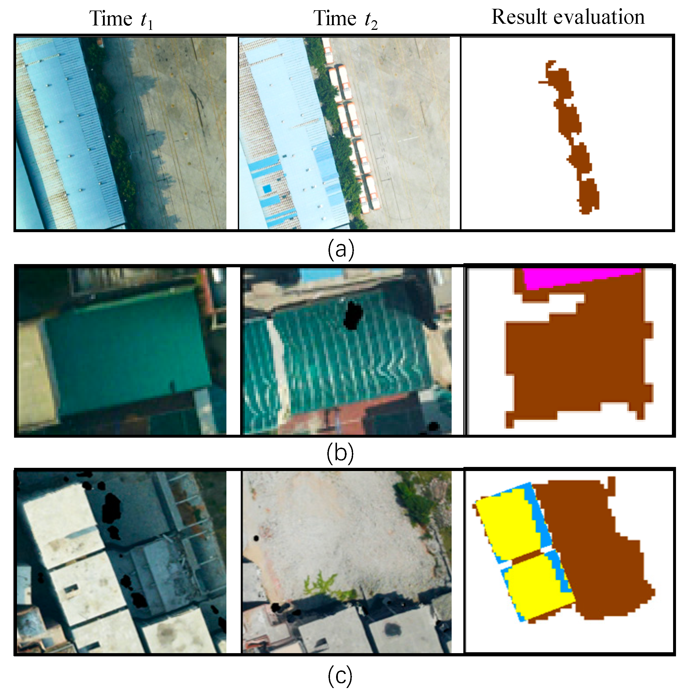
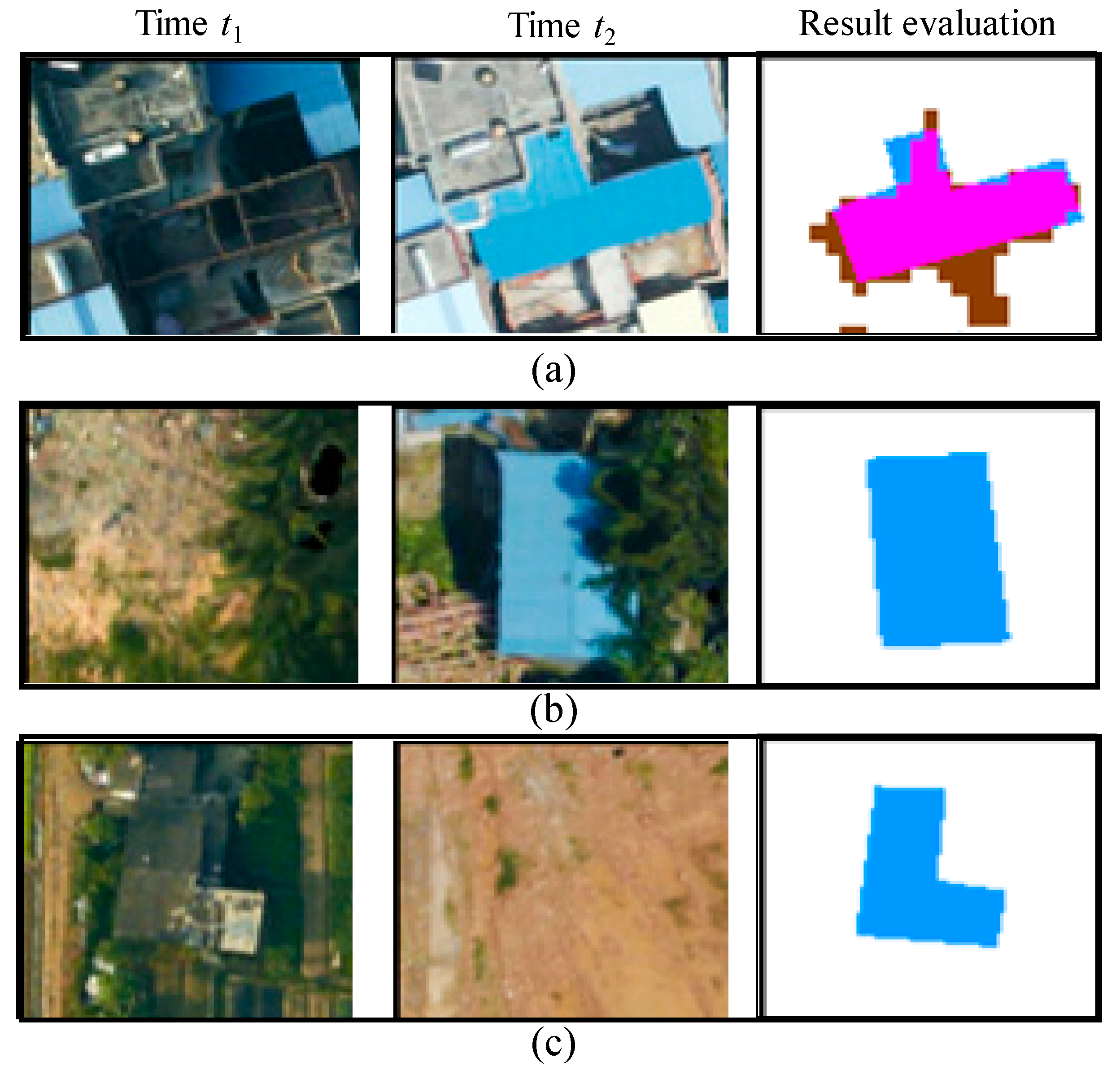
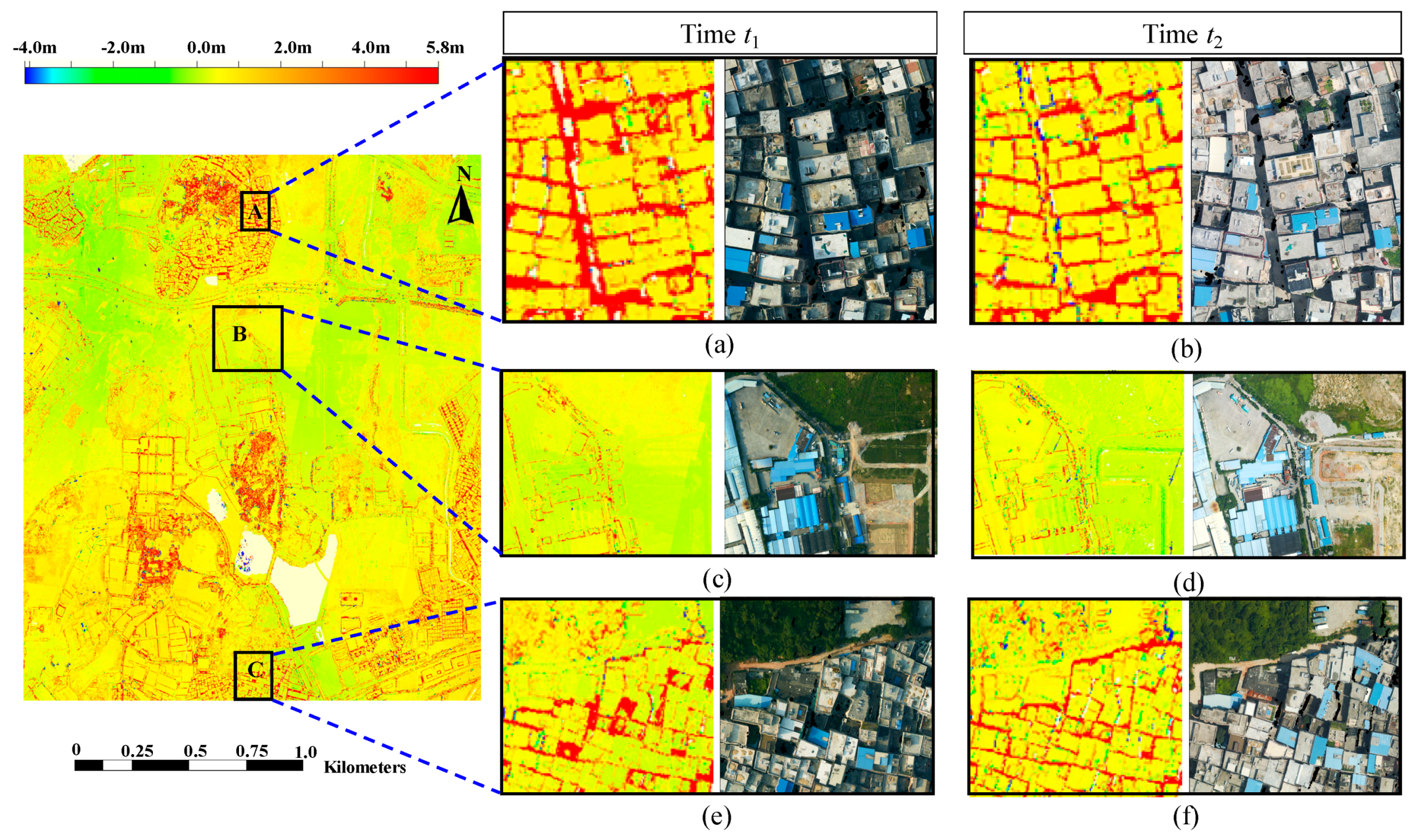


| Time t1/Time t2 | Changed Building | No Building Change |
|---|---|---|
| Changed Building | Taller, if DSMt1 < DSMt2 Lower, if DSMt1 > DSMt2 | Demolished |
| No building change | Newly built | No building change |
| Dataset | Shooting Time | Camera | Focal Length | Image Size | Pixel Size | GSD | Number of Images | Forward Lap | Side Lap |
|---|---|---|---|---|---|---|---|---|---|
| t1 | 2012 | DMC | 120 mm | 7680 × 13,824 | 12 µm | 17 cm | 10 | 65% | 35% |
| t2 | 2013 | DMC | 120 mm | 7680 × 13,824 | 12 µm | 17 cm | 10 | 65% | 35% |
| Dataset | Shooting Time | Camera | Focal Length | Image Size | Pixel Size | GSD | Number of Images | Forward Lap |
|---|---|---|---|---|---|---|---|---|
| t1 | September 2011 | P65+ | 52 mm | 5989 × 4488 | 9 µm | 13 cm | 55 | 70% |
| t2 | August 2012 | P65+ | 52 mm | 5989 × 4488 | 9 µm | 13 cm | 66 | 70% |
| Proposed\Ground Truth | No Building Change | Newly Built | Taller | Demolished | Lower |
|---|---|---|---|---|---|
| No building change | N11 | N12 | N13 | N14 | N15 |
| Newly built | N21 | N22 | N23 | N24 | N25 |
| Taller | N31 | N32 | N33 | N34 | N35 |
| Demolished | N41 | N42 | N43 | N44 | N45 |
| Lower | N51 | N52 | N53 | N54 | N55 |
| Datasets | Pixel-Based Statistics | |||
|---|---|---|---|---|
| Cr | Cm | Q | ||
| Nanning | 2011 | 73.8% | 87.2% | 97.7% |
| 2012 | 62.4% | 83.3% | 95.7% | |
| Guangzhou | 2012 | 82.1% | 92.4% | 93.2% |
| 2013 | 81.0% | 90.9% | 92.3% | |
| Methods | Pixel-Based Statistics | Object-Based Statistics | ||||
|---|---|---|---|---|---|---|
| Cr | Cm | Q | Cr | Cm | Q | |
| SemanticDIF | 37.0% | 62.8% | 94.6% | - | - | - |
| DSMDIF | 17.9% | 86.0% | 84.8% | - | - | - |
| Post-refinement | 61.2% | 62.6% | 97.6% | 88.6% | 98.0% | 86.9% |
| Proposed | 64.1% | 64.0% | 97.8% | 92.9% | 96.8% | 90.1% |
| Proposed\Ground Truth | No Building Change | Newly Built | Taller | Demolished | Lower | |
|---|---|---|---|---|---|---|
| LiDAR-DSM+LiDAR-DTM+IMAGES | No building change | 0 | 11 | 1 | 9 | 0 |
| Newly built | 12 | 101 | 9 | 0 | 0 | |
| Taller | 1 | 0 | 107 | 0 | 0 | |
| Demolished | 11 | 0 | 1 | 44 | 0 | |
| Lower | 1 | 0 | 0 | 0 | 2 | |
| Dense image matching digital surface models (DIM-DSM)+ DIM-DTM+ IMAGES | No building change | 0 | 19 | 4 | 13 | 0 |
| Newly built | 52 | 90 | 6 | 0 | 0 | |
| Taller | 6 | 1 | 105 | 0 | 0 | |
| Demolished | 44 | 0 | 3 | 40 | 0 | |
| Lower | 7 | 0 | 0 | 0 | 2 | |
| Proposed\Ground Truth | Dataset 1 | Dataset 2 | |||||
|---|---|---|---|---|---|---|---|
| Cr | Cm | Q | Cr | Cm | Q | ||
| LiDAR | LiDAR-DSM+ LiDAR-DTM+IMAGES | - | 87.9% | 92.4% | 81.9% | ||
| LiDAR-DSM+IMAGES | - | 75.6% | 92.4% | 71.2% | |||
| DIM | Dense image matching digital surface models (DIM-DSM)+ LiDAR-DTM+IMAGES | - | 70.7% | 89.8% | 65.4% | ||
| DIM-DSM+DIM-DTM+IMAGES | 92.9% | 96.8% | 90.1% | 66.6% | 86.8% | 60.5% | |
| DIM-DSM+IMAGES | 82.4% | 96.7% | 80.2% | 59.8% | 89.7% | 56.0% | |
© 2019 by the authors. Licensee MDPI, Basel, Switzerland. This article is an open access article distributed under the terms and conditions of the Creative Commons Attribution (CC BY) license (http://creativecommons.org/licenses/by/4.0/).
Share and Cite
Pang, S.; Hu, X.; Zhang, M.; Cai, Z.; Liu, F. Co-Segmentation and Superpixel-Based Graph Cuts for Building Change Detection from Bi-Temporal Digital Surface Models and Aerial Images. Remote Sens. 2019, 11, 729. https://doi.org/10.3390/rs11060729
Pang S, Hu X, Zhang M, Cai Z, Liu F. Co-Segmentation and Superpixel-Based Graph Cuts for Building Change Detection from Bi-Temporal Digital Surface Models and Aerial Images. Remote Sensing. 2019; 11(6):729. https://doi.org/10.3390/rs11060729
Chicago/Turabian StylePang, Shiyan, Xiangyun Hu, Mi Zhang, Zhongliang Cai, and Fengzhu Liu. 2019. "Co-Segmentation and Superpixel-Based Graph Cuts for Building Change Detection from Bi-Temporal Digital Surface Models and Aerial Images" Remote Sensing 11, no. 6: 729. https://doi.org/10.3390/rs11060729
APA StylePang, S., Hu, X., Zhang, M., Cai, Z., & Liu, F. (2019). Co-Segmentation and Superpixel-Based Graph Cuts for Building Change Detection from Bi-Temporal Digital Surface Models and Aerial Images. Remote Sensing, 11(6), 729. https://doi.org/10.3390/rs11060729