Sentinel 2 Analysis of Turbidity Patterns in a Coastal Lagoon

 ,
,  ,
,  and
and 
Abstract
1. Introduction
2. Materials and Methods
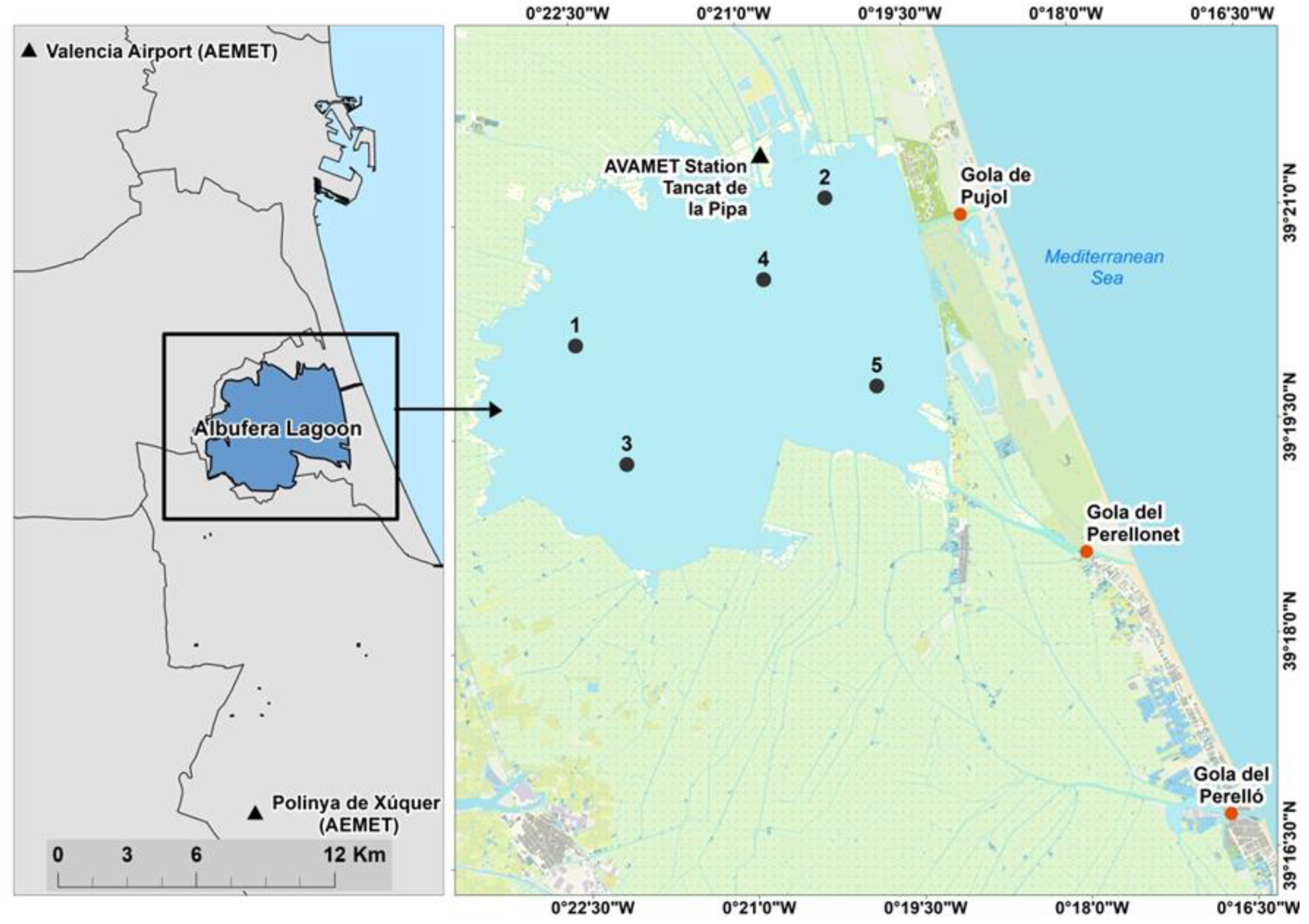
2.1. Study Area
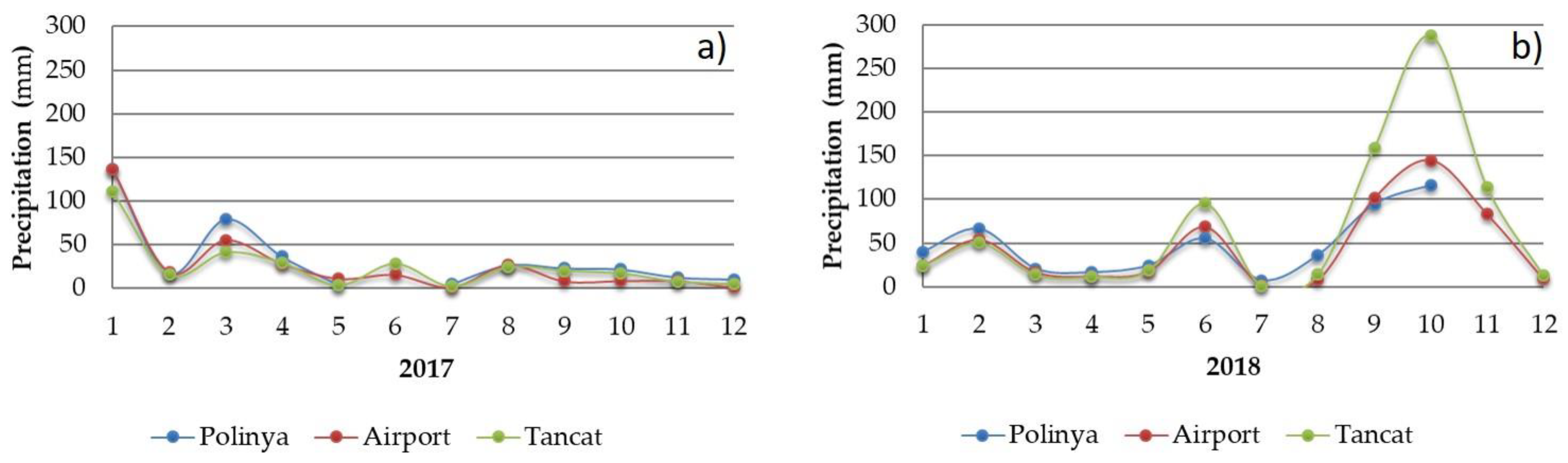
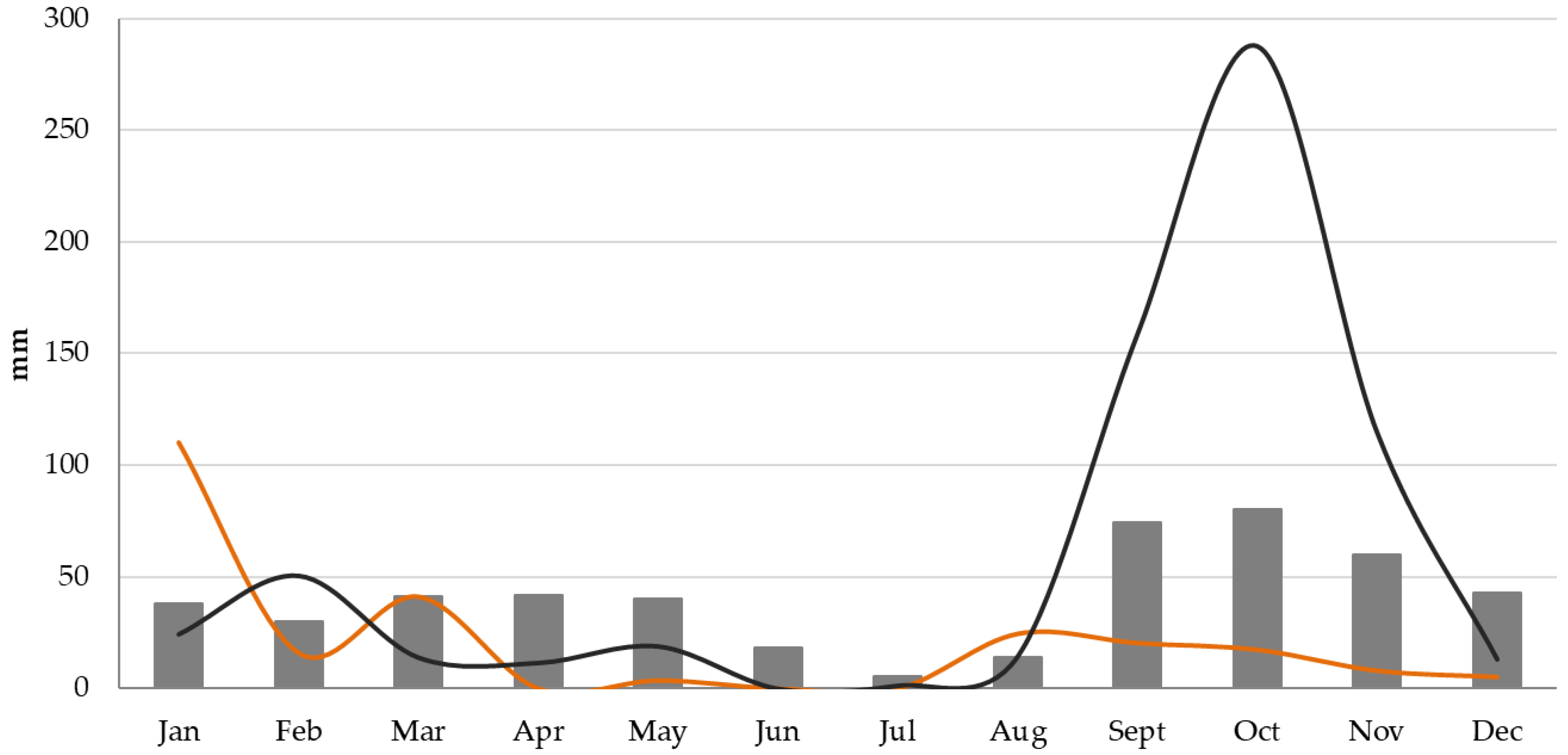
2.2. Precipitation and Wind Data
2.3. Secchi Disk and Suspended Matter
2.4. Satellite Data
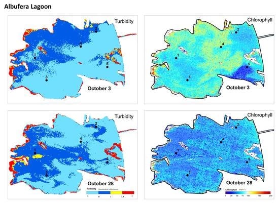
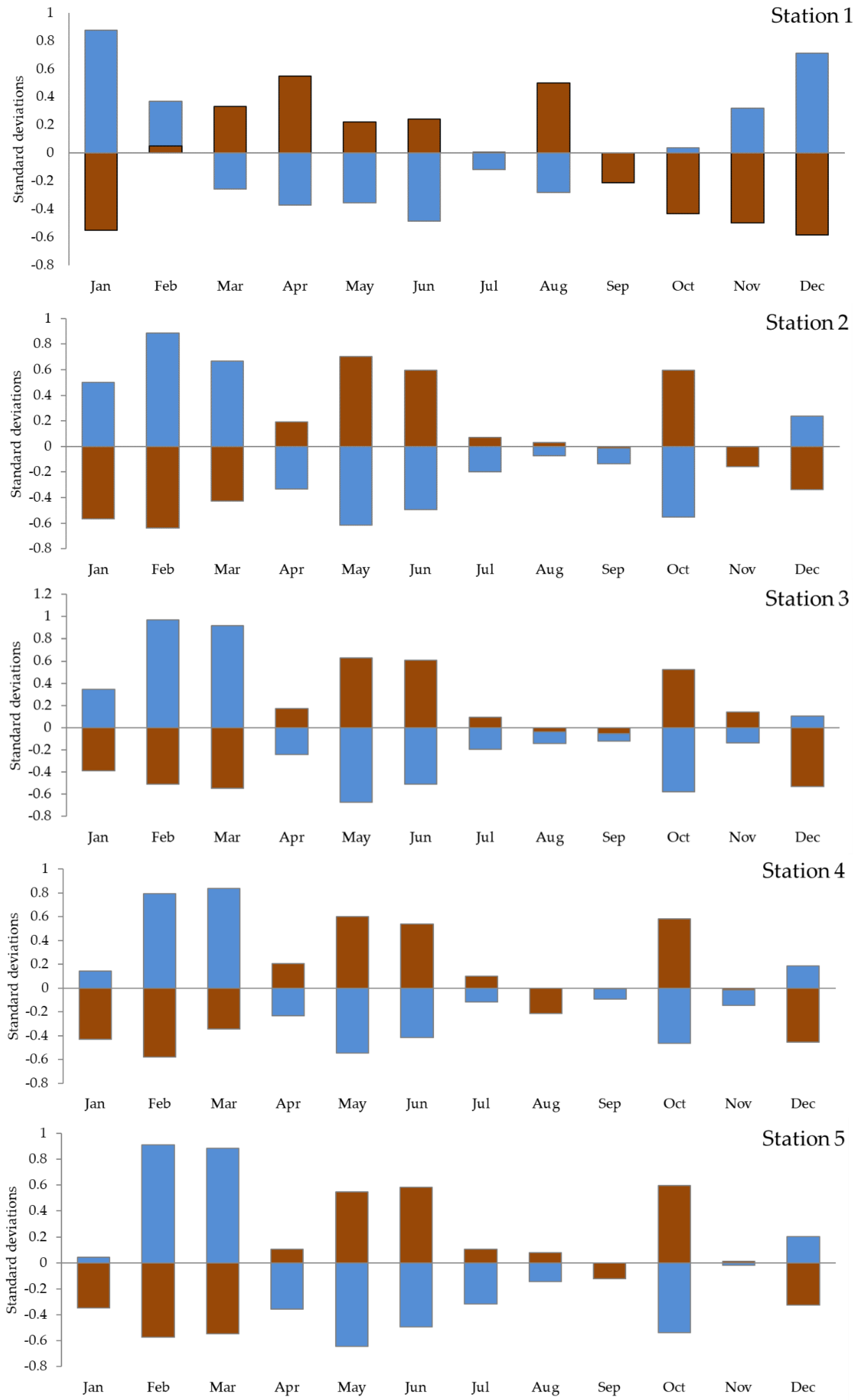
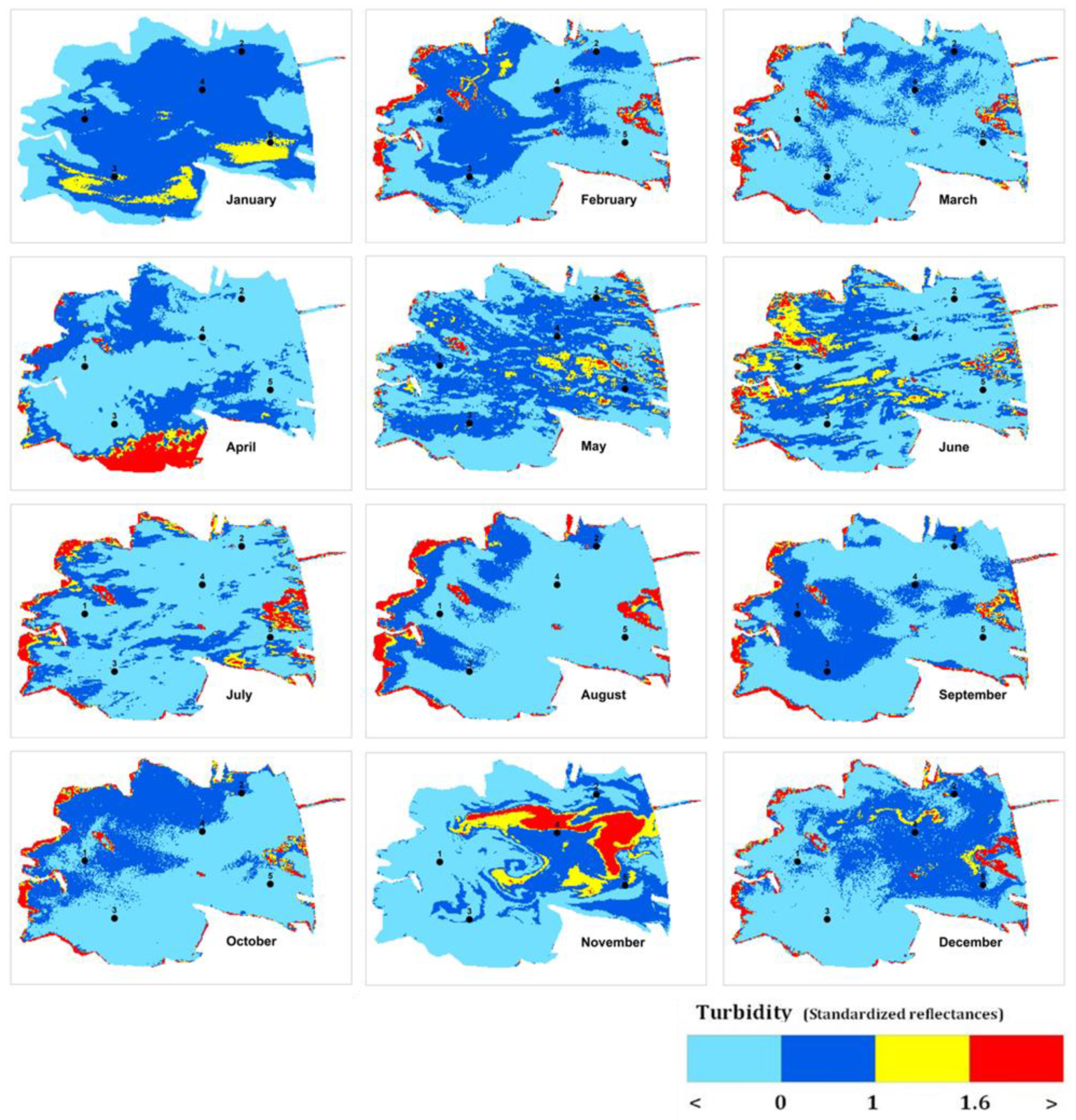
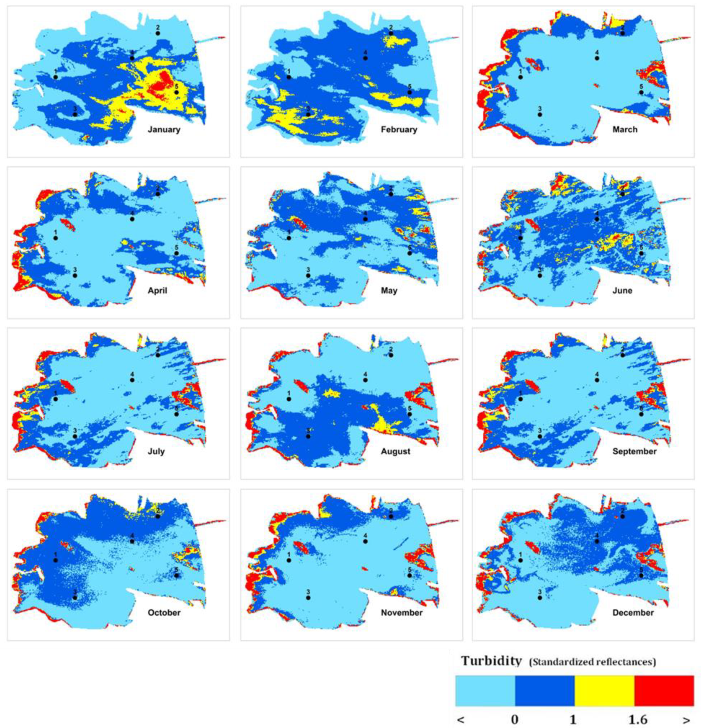
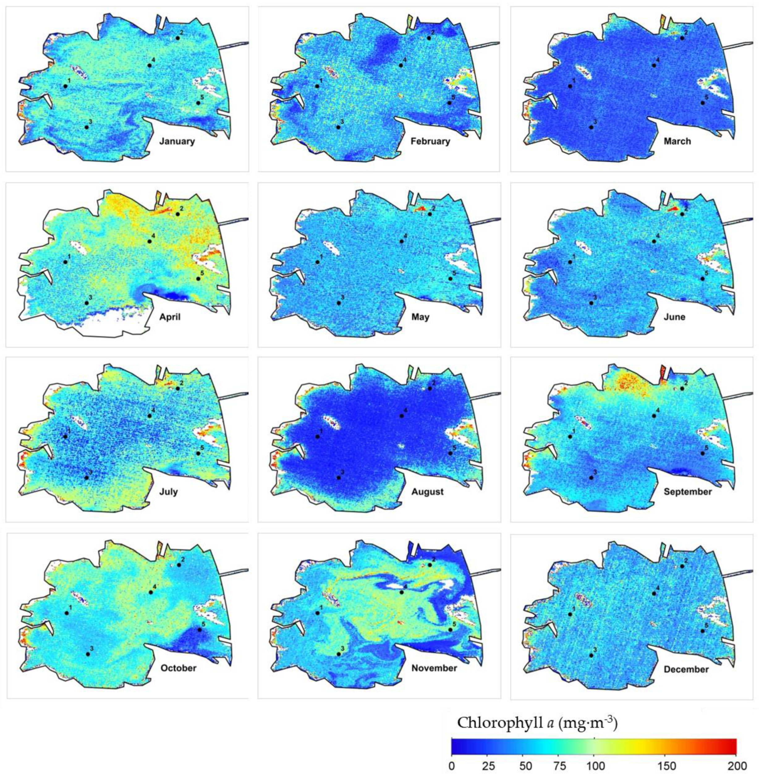
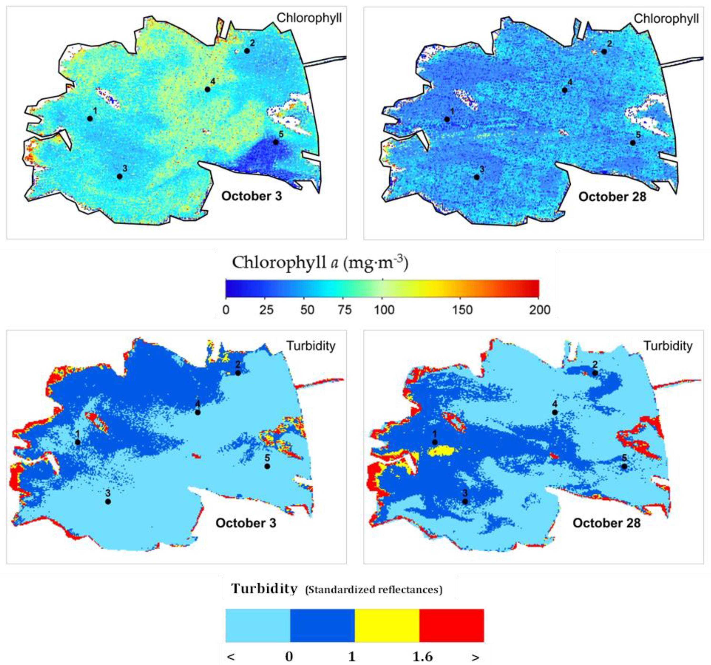
3. Results
4. Discussion
5. Conclusions
Author Contributions
Funding
Acknowledgments
Conflicts of Interest
References
- Riera, R.; Tuset, V.M.; Betancur-R, R.; Lombarte, A.; Marcos, C.; Pérez-Ruzafa, A. Modelling alpha-diversities of coastal lagoon fish assemblages from the Mediterranean Sea. Prog. Oceanogr. 2018, 165, 100–109. [Google Scholar] [CrossRef]
- Sebastiá-Frasquet, M.-T.; Altur, V.; Sanchis, J.-A. Wetland Planning: Current Problems and Environmental Management Proposals at Supra-Municipal Scale (Spanish Mediterranean Coast). Water 2014, 6, 620–641. [Google Scholar] [CrossRef]
- Doña, C.; Chang, N.B.; Caselles, V.; Sánchez, J.M.; Camacho, A.; Delegido, J.; Vannah, B.W. Integrated satellite data fusion and mining for monitoring lake water quality status of the Albufera de Valencia in Spain. J. Environ. Manag. 2015, 151, 416–426. [Google Scholar] [CrossRef]
- Gernez, P.; Lafon, V.; Lerouxel, A.; Curti, C.; Lubac, B.; Cerisier, S.; Barillé, L. Toward Sentinel-2 High Resolution Remote Sensing of Suspended Particulate Matter in Very Turbid Waters: SPOT4 (Take5) Experiment in the Loire and Gironde Estuaries. Remote Sens. 2015, 7, 9507–9528. [Google Scholar] [CrossRef]
- Caballero, I.; Navarro, G.; Ruiz, J. Multi-platform assessment of turbidity plumes during dredging operations in a major estuarine system. Int. J. Appl. Earth Obs. Geoinf. 2018, 68, 31–41. [Google Scholar] [CrossRef]
- Onandia, G.; Gudimov, A.; Miracle, M.R.; Arhonditsis, G. Towards the development of a biogeochemical model for addressing the eutrophication problems in the shallow hypertrophic lagoon of Albufera de Valencia, Spain. Ecol. Inform. 2015, 26, 70–89. [Google Scholar] [CrossRef]
- Sòria-Perpinyà, X.; Vicente, E.; Urrego, P.; Pereira-Sandoval, M.; Ruíz-Verdú, A.; Delegido, J.; Soria, J.M.; Moreno, J. Remote sensing of cyanobacterial blooms in a hypertrophic lagoon (Albufera of València, Eastern Iberian Peninsula) using multitemporal Sentinel-2 images. Sci. Total Environ. 2020, 698, 134305. [Google Scholar] [CrossRef] [PubMed]
- Sòria-Perpinyà, X.; Urrego, P.; Pereira-Sandoval, M.; Ruiz-Verdú, A.; Peña, R.; Soria, J.M.; Delegido, J.; Vicente, E.; Moreno, J. Monitoring the ecological state of a hypertrophic lake (Albufera of València, Spain) using multitemporal Sentinel-2 images. Limnetica 2019, 38, 457–469. [Google Scholar]
- Güttler, F.N.; Niculescu, S.; Gohin, F. Turbidity retrieval and monitoring of Danube Delta waters using multi-sensor optical remote sensing data: An integrated view from the delta plain lakes to the western–northwestern Black Sea coastal zone. Remote Sens. Environ. 2013, 132, 86–101. [Google Scholar] [CrossRef]
- Quang, N.H.; Sasaki, J.; Higa, H.; Huan, N.H. Spatiotemporal Variation of Turbidity Based on Landsat 8 OLI in Cam Ranh Bay and Thuy Trieu Lagoon, Vietnam. Water 2017, 9, 570. [Google Scholar] [CrossRef]
- Kari, E.; Kratzer, S.; Beltrán-Abaunza, J.M.; Harvey, E.T.; Vaičiūtė, D. Retrieval of suspended particulate matter from turbidity-model development, validation, and application to MERIS data over the Baltic Sea. Int. J. Remote Sens. 2017, 38, 1983–2003. [Google Scholar] [CrossRef]
- Kuhn, C.; de Matos Valerio, A.; Ward, N.; Loken, L.; Oliveira Sawakuchi, H.; Kampel, M.; Richey, J.; Stadler, P.; Crawford, J.; Striegl, R.; et al. Performance of Landsat-8 and Sentinel-2 surface reflectance products for river remote sensing retrievals of chlorophyll-a and turbidity. Remote Sens. Environ. 2019, 224, 104–118. [Google Scholar] [CrossRef]
- Liu, H.; Li, Q.; Shi, T.; Hu, S.; Wu, G.; Zhou, Q. Application of Sentinel 2 MSI Images to Retrieve Suspended Particulate Matter Concentrations in Poyang Lake. Remote Sens. 2017, 9, 761. [Google Scholar] [CrossRef]
- Erena, M.; Domínguez, J.A.; Aguado-Giménez, F.; Soria, J.; García-Galiano, S. Monitoring Coastal Lagoon Water Quality through Remote Sensing: The Mar Menor as a Case Study. Water 2019, 11, 1468. [Google Scholar] [CrossRef]
- Caballero, I.; Stumpf, R.P.; Meredith, A. Preliminary Assessment of Turbidity and Chlorophyll Impact on Bathymetry Derived from Sentinel-2A and Sentinel-3A Satellites in South Florida. Remote Sens. 2019, 11, 645. [Google Scholar] [CrossRef]
- Vanhellemont, Q.; Ruddick, K. Acolite for Sentinel-2: Aquatic applications of MSI imagery. In Proceedings of the 2016 ESA Living Planet Symposium, Prague, Czech Republic, 9–13 May 2016. [Google Scholar]
- IOCCG. Remote Sensing of Ocean Colour in Coastal, and Other Optically-Complex, Waters; Reports of the International Ocean-Colour Coordinating Group, No. 3; Sathyendranath, S., Ed.; IOCCG: Dartmouth, NS, Canada, 2000. [Google Scholar]
- Toming, K.; Kutser, T.; Laas, A.; Sepp, M.; Paavel, B.; Nõges, T. First experiences in mapping lake water quality parameters with Sentinel-2 MSI imagery. Remote Sens. 2016, 8, 640. [Google Scholar] [CrossRef]
- Soria, J.M.; Miracle, M.R.; Vicente, E. Aporte de nutrientes y eutrofización de la Albufera de Valencia. Limnetica 1987, 3, 227–242. [Google Scholar]
- Soria, X.; Delegido, J.; Urrego, E.P.; Pereira-Sandoval, M.; Vicente, E.; Ruíz-Verdú, A.; Moreno, J. Validación de algoritmos para la estimación de la clorofila-a con Sentinel-2 en la Albufera de València. In Proceedings of the XVII Congreso de la Asociación Española de Teledetección, Murcia, Spain, 3–7 October 2017; pp. 289–292. [Google Scholar]
- Usaquén Perilla, O.L.; García Gómez, A.; Álvarez Díaz, C.; Revilla Cortezón, J.A. Methodology to assess sustainable management of water resources in coastal lagoons with agricultural uses: An application to the Albufera lagoon of Valencia (Eastern Spain). Ecol. Indic. 2012, 13, 129–143. [Google Scholar] [CrossRef]
- Soria, J.M.; Vicente, E.; Miracle, M.R. The influence of flash floods on the limnology of the Albufera of Valencia lagoon (Spain). Int. Ver. Theor. Angew. Limnol. Verh. 2000, 27, 2232–2235. [Google Scholar] [CrossRef]
- Romo, S.; García-Murcia, A.; Villena, M.J.; Sanchez, V.; Ballester, A. Phytoplankton trends in the lake of Albufera de Valencia and implications for its ecology, management, and recovery. Limnetica 2008, 27, 11–28. [Google Scholar]
- Vicente, E.; Miracle, M.R. The coastal lagoon Albufera de Valencia: An ecosystem under stress. Limnetica 1992, 8, 87–100. [Google Scholar]
- Wang, S.; Lee, Z.; Shang, S.; Li, J.; Zhang, B.; Lin, G. Deriving inherent optical properties from classical water color measurements: Forel-Ule index and Secchi disk depth. Opt. Express 2019, 27, 7642–7655. [Google Scholar] [CrossRef] [PubMed]
- Wernand, M.R. On the history of the Secchi disc. J. Eur. Opt. Soc.-Rapid Publ. 2010. [Google Scholar] [CrossRef]
- Santamaría-del-Ángel, E.; Sebastia-Frasquet, M.T.; Gonzalez-Silvera, A.; Aguilar-Maldonado, J.; Mercado-Santana, A.; Herrera-Carmona, J. Uso Potencial de las Anomalías Estandarizadas en la Interpretación de Fenómenos Oceanográficos Globales a Escalas Locales. In Costas y Mares Mexicanos: Construyendo la Línea Base para su Futuro Sostenible, Oceanografía Fisicoquímica; Rivera-Arriaga, E., Sánchéz-Gil, P., Gutiérrez, J., Eds.; EPOMEX: Campeche, Mexico; Universidad Autónoma de Colima: Colima, Mexico, 2019. [Google Scholar]
- Aguilar-Maldonado, J.A.; Santamaría-del-Ángel, E.; Gonzalez-Silvera, A.; Sebastiá-Frasquet, M.T. Detection of Phytoplankton Temporal Anomalies Based on Satellite Inherent Optical Properties: A Tool for Monitoring Phytoplankton Blooms. Sensors 2019, 19, 3339. [Google Scholar] [CrossRef] [PubMed]
- Pereira-Sandoval, M.; Ruescas, A.; Urrego, P.; Ruiz-Verdú, A.; Delegido, J.; Tenjo, C.; Soria-Perpinyà, X.; Vicente, E.; Soria, J.; Moreno, J. Evaluation of Atmospheric Correction Algorithms over Spanish Inland Waters for Sentinel-2 Multi Spectral Imagery Data. Remote Sens. 2019, 11, 1469. [Google Scholar] [CrossRef]
- Soria, J.M. Past, present and future of la Albufera of Valencia Natural Park. Limnetica 2006, 25, 135–142. [Google Scholar]
- Miracle, M.R.; Sahuquillo, M. Changes of life-history traits and size in Daphnia magna during a lear-water phase in a hypertrophic lagoon (Albufera of Valencia, Spain). Int. Ver. Theor. Angew. Limnol. Verh. 2002, 28, 1203–1208. [Google Scholar]
- Sòria-Perpinyà, X.; Miracle, M.R.; Soria, J.; Delegido, J.; Vicente, E. Remote sensing application for the study of rapid flushing to remediate eutrophication in shallow lagoons (Albufera of Valencia). Hydrobiologia 2019, 829, 125–132. [Google Scholar] [CrossRef]
- Rodrigo, M.A.; Alonso-Guillén, J.A. Assessing the potential of Albufera de València Lagoon sediments for the restoration of charophyte meadows. Ecol. Eng. 2013, 60, 445–452. [Google Scholar] [CrossRef]
- Martín, M.; Oliver, N.; Hernández-Crespo, C.; Gargallo, S.; Regidor, M. The use of free water surface constructed wetland to treat the eutrophicated waters of lake L’Albufera de Valencia (Spain). Ecol. Eng. 2013, 50, 52–61. [Google Scholar] [CrossRef]


| Year 2018 | Year 2017 |
|---|---|
| 11 January | 16 January |
| 20 February | 5 February |
| 27 March | 17 March |
| 26 April | 16 April |
| 21 May | 16 May |
| 20 June | 15 June |
| 10 July | 10 July |
| 19 August | 4 August |
| 13 September | 13 September |
| 3 October | 13 October |
| 27 November | 22 November |
| 22 December | 17 December |
| SPM (mg/L) | SDD (cm) | Chla (mg m−3) | |||||||||||||
|---|---|---|---|---|---|---|---|---|---|---|---|---|---|---|---|
| Data | Station | ||||||||||||||
| 1 | 2 | 3 | 4 | 5 | 1 | 2 | 3 | 4 | 5 | 1 | 2 | 3 | 4 | 5 | |
| 18 January 2017 | 28 | 34 | 40 | 60 | 60 | 35 | 30 | 33 | 25 | 30 | 10 | 3.7 | 6.9 | 6.4 | 3.9 |
| 9 February 2017 | nd | <1 | <1 | nd | <1 | nd | 30 | 25 | nd | 25 | nd | 48.8 | 39.7 | nd | <0.1 |
| 14 February 2017 | 39 | 41 | 36 | 55 | 81 | 35 | nd | nd | nd | nd | 20.1 | 14.1 | 15.6 | 11.1 | 18.3 |
| 20 March 2017 | 30 | 23 | 13 | 20 | 28 | 40 | 40 | 45 | 50 | 40 | 43.3 | 50.9 | 13.2 | 2.5 | <0.1 |
| 3 April 2017 | 42 | 38 | 37 | 40 | 40 | 35 | 38 | 40 | 38 | 38 | 30.5 | 35 | 8.9 | 13.8 | 2.8 |
| 9 May 2017 | 98 | nd | 90 | 100 | 82 | nd | nd | nd | nd | nd | 46.6 | nd | 33.1 | 32.5 | 22.4 |
| 12 June 2017 | 67 | 140 | 97 | 60 | 105 | 18 | 20 | 14 | 17 | 20 | 33.9 | 27.6 | 88.9 | 74.7 | 57.7 |
| 11 July 2017 | 80 | 48 | 86 | 92 | 86 | 30 | 30 | 25 | 30 | 23 | 42.6 | 18.2 | 39.9 | 51 | 0.7 |
| 7 August 2017 | 25 | nd | 35 | 35 | nd | 30 | 30 | 30 | 30 | 30 | 46.7 | nd | 49.1 | 49 | nd |
| 11 September 2017 | 35 | 35 | 26 | 38 | 43 | 30 | 30 | 30 | 30 | 25 | <0.1 | 37.5 | <0.1 | 48.2 | <0.1 |
| 17 October 2017 | nd | 76 | nd | 67 | 72 | 30 | 20 | nd | 20 | 25 | 65.5 | 157.4 | nd | 197.9 | 172 |
| 20 November 2017 | 58 | 78 | 84 | 31 | 74 | 30 | 37.5 | 30 | 30 | 37.5 | 89 | 60.6 | 70.9 | 69.2 | 72.6 |
| 21 December 2017 | nd | 41 | 43 | nd | 48 | 32 | 30 | 30 | nd | 30 | 61.2 | 73.5 | 75 | nd | 160 |
| 23 January 2018 | 52 | 52 | 50 | nd | 60 | 28 | 30 | 35 | nd | 25 | 84.3 | 71.4 | 82 | nd | 83.6 |
| 19 February 2018 | <1 | 52 | 82 | 29 | 85 | 23 | 35 | 35 | 50 | 35 | 57.1 | 38.3 | 67.3 | 24.3 | 46.3 |
| 1 March 2018 | 73 | 64 | 83 | 88 | 103 | 20 | 31 | 30 | 30 | 29 | 163.1 | 91.1 | 90.1 | 98.6 | <0.1 |
| 17 April 2018 | 66 | 116 | 88 | 92 | 90 | 23 | 25 | 23 | 25 | 25 | <0.1 | 125.6 | 67 | 81.4 | 45.6 |
| 15 May 2018 | 108 | 130 | 130 | 130 | 130 | 30 | 17 | 17 | 20 | 17 | 30.6 | 127.1 | 167.8 | 167.2 | 229.7 |
| 13 June 2018 | <1 | nd | nd | nd | nd | 40 | 25 | 25 | 25 | 25 | 22.5 | nd | nd | nd | nd |
| 11 July 2018 | 28 | 22 | 18 | 34 | 40 | 30 | 35 | 35 | 30 | 30 | 101.1 | 42.9 | 26.3 | 41.3 | 36.2 |
| 20 August 2018 | 22 | 25 | 30 | 35 | 21 | 25 | 35 | 42 | 35 | 37 | 108.4 | 26.2 | 23.5 | 25.7 | 23.1 |
| 18 September 2018 | nd | 8 | nd | 9 | 25 | 25 | 35 | nd | 35 | 35 | nd | 61.6 | nd | 101.1 | 38.4 |
| 17 October 2018 | 46 | 38 | 53 | 51 | 50 | nd | 30 | 30 | 30 | 30 | nd | 130.1 | 92.3 | 137 | 117.3 |
| 12 November 2018 | 28 | 20 | 20 | 18 | 15 | nd | 30 | 30 | 30 | 30 | nd | 157.8 | 143.3 | 172.1 | 130.5 |
| 11 December 2018 | nd | nd | nd | nd | nd | nd | 35 | 40 | nd | 50 | nd | nd | nd | nd | nd |
| 17 December 2018 | nd | nd | nd | nd | nd | nd | 25 | 25 | 25 | 25 | nd | nd | nd | nd | nd |
| Average | 49 | 49 | 52 | 52 | 58 | 28 | 29 | 29 | 29 | 29 | 55.7 | 63.7 | 57.3 | 67.1 | 66.6 |
| SD | 32 | 40 | 38 | 36 | 38 | 14 | 11 | 14 | 15 | 11 | 41.9 | 50 | 45.8 | 59 | 63.1 |
| 2017 | 2018 | |||
|---|---|---|---|---|
| Sampling Stations | Spearman Correlation | p-Value | Spearman Correlation | p-Value |
| 1 | 0.613 | 0.034 | 0.614 | 0.034 |
| 2 | 0.860 | 0.000 | 0.557 | 0.060 |
| 3 | 0.887 | 0.000 | 0.665 | 0.018 |
| 4 | 0.897 | 0.000 | 0.658 | 0.020 |
| 5 | 0.622 | 0.031 | 0.594 | 0.042 |
© 2019 by the authors. Licensee MDPI, Basel, Switzerland. This article is an open access article distributed under the terms and conditions of the Creative Commons Attribution (CC BY) license (http://creativecommons.org/licenses/by/4.0/).
Share and Cite
Sebastiá-Frasquet, M.-T.; Aguilar-Maldonado, J.A.; Santamaría-Del-Ángel, E.; Estornell, J. Sentinel 2 Analysis of Turbidity Patterns in a Coastal Lagoon. Remote Sens. 2019, 11, 2926. https://doi.org/10.3390/rs11242926
Sebastiá-Frasquet M-T, Aguilar-Maldonado JA, Santamaría-Del-Ángel E, Estornell J. Sentinel 2 Analysis of Turbidity Patterns in a Coastal Lagoon. Remote Sensing. 2019; 11(24):2926. https://doi.org/10.3390/rs11242926
Chicago/Turabian StyleSebastiá-Frasquet, María-Teresa, Jesús A. Aguilar-Maldonado, Eduardo Santamaría-Del-Ángel, and Javier Estornell. 2019. "Sentinel 2 Analysis of Turbidity Patterns in a Coastal Lagoon" Remote Sensing 11, no. 24: 2926. https://doi.org/10.3390/rs11242926
APA StyleSebastiá-Frasquet, M.-T., Aguilar-Maldonado, J. A., Santamaría-Del-Ángel, E., & Estornell, J. (2019). Sentinel 2 Analysis of Turbidity Patterns in a Coastal Lagoon. Remote Sensing, 11(24), 2926. https://doi.org/10.3390/rs11242926