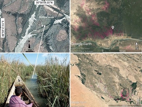
1. Introduction
Remote sensing using aerial photography or satellite imagery has played an important role in the mapping of ancient routes, preserved as hollow ways for nearly a century [
1]. Hollow ways, or eroded paths through the landscape, occur in many regions of the world, including North America [
2], the Caribbean [
3], Europe [
4,
5], and the Near East [
6,
7,
8,
9]. Hollow ways are formed by erosion from the traction of people and/or their animals walking the same route repeatedly [
3,
5,
10]. As trace fossils formed by traction, they are the primary source of direct evidence of past human movement in the archaeological record besides footprints (such as in the work of [
11]). Consequently, they are important features for understanding past travel practices. For example, in Costa Rica, Sheets [
3] has described how hollow ways dating back 2500 years are consistent with the modern cultural practice of walking in a straight, single-file line between villages and cemeteries. Meanwhile, in the Jazira region of northern Syria and Iraq, Wilkinson [
12] (pp. 111–120) distinguished three types of hollow way associated with three different activities: (1) regular travel from settlements to/from surrounding agricultural fields, (2) travel with flocks between settlements to/from pasture land beyond the agricultural fields, and (3) travel between settlements. Since, the development of a quantitative method for directly comparing digital route models with preserved hollow ways has enabled hypothesis testing of travel practices—did people travel fastest routes as people sometimes do today, easiest routes, shortest routes, or did they prioritize cultural variables in their movements like seeking permission from local headmen before travelling through different territories [
13,
14,
15]. The hollow ways presented in this paper are hypothesized to be the result of an entirely different type movement: the movement of boats and possibly of the water buffalo traditionally herded in the area.
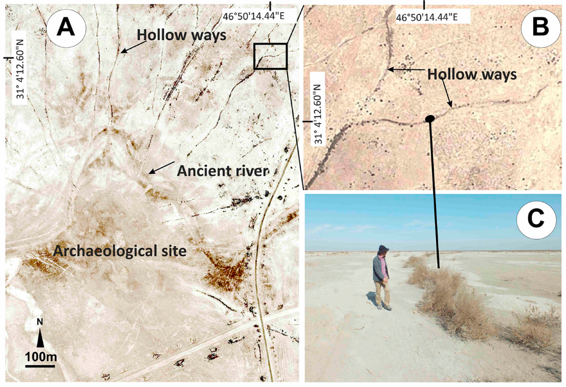
In the Near East, hollow ways are visible in satellite imagery as dark, broad, shallow, linear depressions across the landscape owing to a difference in soil drainage; increased moisture levels; and, consequently, increased vegetation [
6,
7,
8,
16,
17]. A detailed study of these features in the North Jazira of Northern Mesopotamia was carried out by Ur [
9,
18,
19] using CORONA imagery, which resulted in a map of over 6000 hollow way segments. To date, only three of these hollow way segments, all located around Tell Brak in northern Syria, have been excavated. It is from this limited sample that hollow ways have been dated back to at least the third millennium BC [
10], however, as negative features formed through erosion, material excavated from a hollow way dates to after its final abandonment [
10] (Figure 13 therein). Dating by association using the dates of settlements connected to hollow ways provides an alternative means for estimating the age of hollow ways. In the North Jazira, the excavated fill of one of the three excavated hollow ways may date back to the third millennium BC [
10], but sites dating back to the early fourth millennium BC have been observed in linear arrangements, consistent with placement along a route or hollow way, and other early fourth millennium BC sites have been found alongside preserved hollow way segments [
14,
17].
Additional dating evidence for hollow ways may derive from historic texts, or other dated features in the landscape that cut or are cut by the hollow ways. In Southern Mesopotamia, the dates of any palaeochannels that cut or are cut by hollow ways provide terminus post quem or terminus ante quem dates for those hollow ways.
While hollow ways in the Near East are most often associated with archaeological sites in the North Jazira [
1,
6,
7,
16,
17,
20,
21,
22], they also appear in other parts of the region (
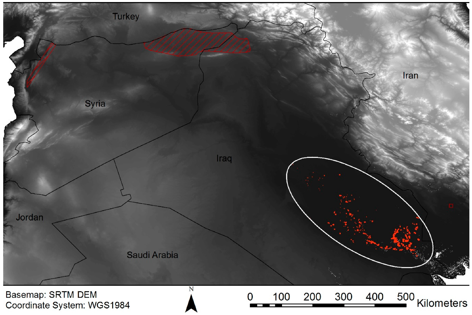
Figure 1). Altaweel and Hauser [
23] described hollow ways in the Eastern Jazira, while Casana [
8] examined the hollow ways in the Orontes river valley, Syria, and Khuzistan, Iran. Similarly, Pournelle [
24] and Al-Dafar [
25] have briefly described the ‘water-passages’/hollow ways used by marsh inhabitants in Southern Mesopotamia. Pournelle [
24] and Al-Dafar [
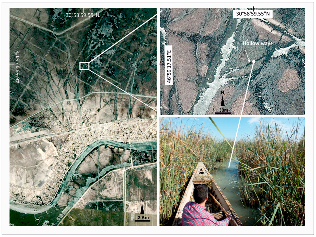
25] argue that the formation of these features in Southern Mesopotamia was the result of small wooden boats—the main transportation method in the marshes and buffalo traffic through dense reeds—a view the present authors share (
Figure 2). This means that, like hollow ways elsewhere in the Near East, hollow ways in Southern Mesopotamia are the direct result of erosional processes caused by human and animal traffic moving from sites to either other sites or activity areas and back again. Therefore, like hollow ways in other parts of the Near East, the hollow ways in Southern Mesopotamia are valuable trace fossils of past behavior (see the works of [
13,
14]). For this reason, the ‘water-passage’ features in the marshland of Southern Mesopotamia are considered equivalent features to the hollow ways in the other regions of greater Mesopotamia. Nonetheless, the hollow ways in Southern Mesopotamia have not been studied as intensively as those in Northern Mesopotamia, nor has there been any prior effort to map them. In fact, no previous work has discussed these features in detail at all, although a forthcoming chapter separate from this study describes the hollow ways around Abu Tbeirah [
26].
Despite the value of hollow ways as trace fossils of past human movement (with or without animals) and their presence in other areas of the Near East [
6,
7,
8], there has never been a concerted effort to use remote sensing to survey or map hollow ways in Southern Mesopotamia. This paper presents the culmination of the first remote sensing survey of hollow ways in Southern Mesopotamia, provides the resulting map as
supplementary data, and discusses what the new hollow ways tell us about past behavior.
2. Materials and Methods
Methods of landscape feature identification in the Mesopotamian floodplain using satellite remote sensing were examined in detail by Jotheri and Allen [
28], including several visual elements such as tone, pattern, shape, elevation, size, and situation. In the present study, these observations were applied to hollow way features. Hollow ways are visible in aerial photography and satellite imagery. By comparison, on the ground, they can be difficult to see owing to their large size (meters wide, kilometers long) and relatively shallow depth (perhaps 50 cm in the center). In aerial photographs and satellite imagery, however, hollow ways appear as dark lines with lighter borders owing to increased moisture towards the middle where they are deepest and calcium carbonate buildup from increased evaporation along their sloping sides [
8,
10,
18,
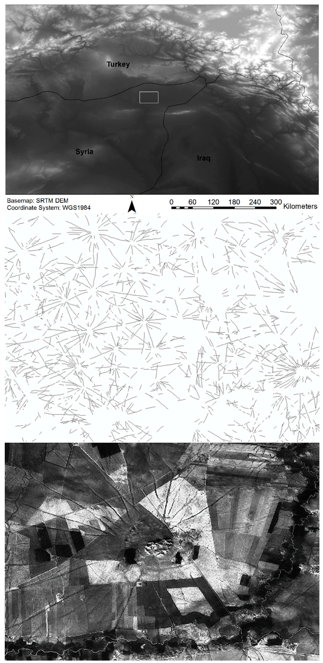
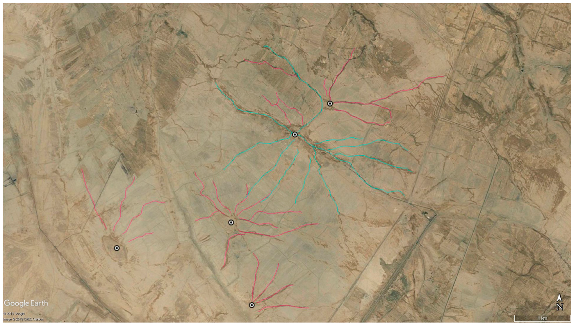
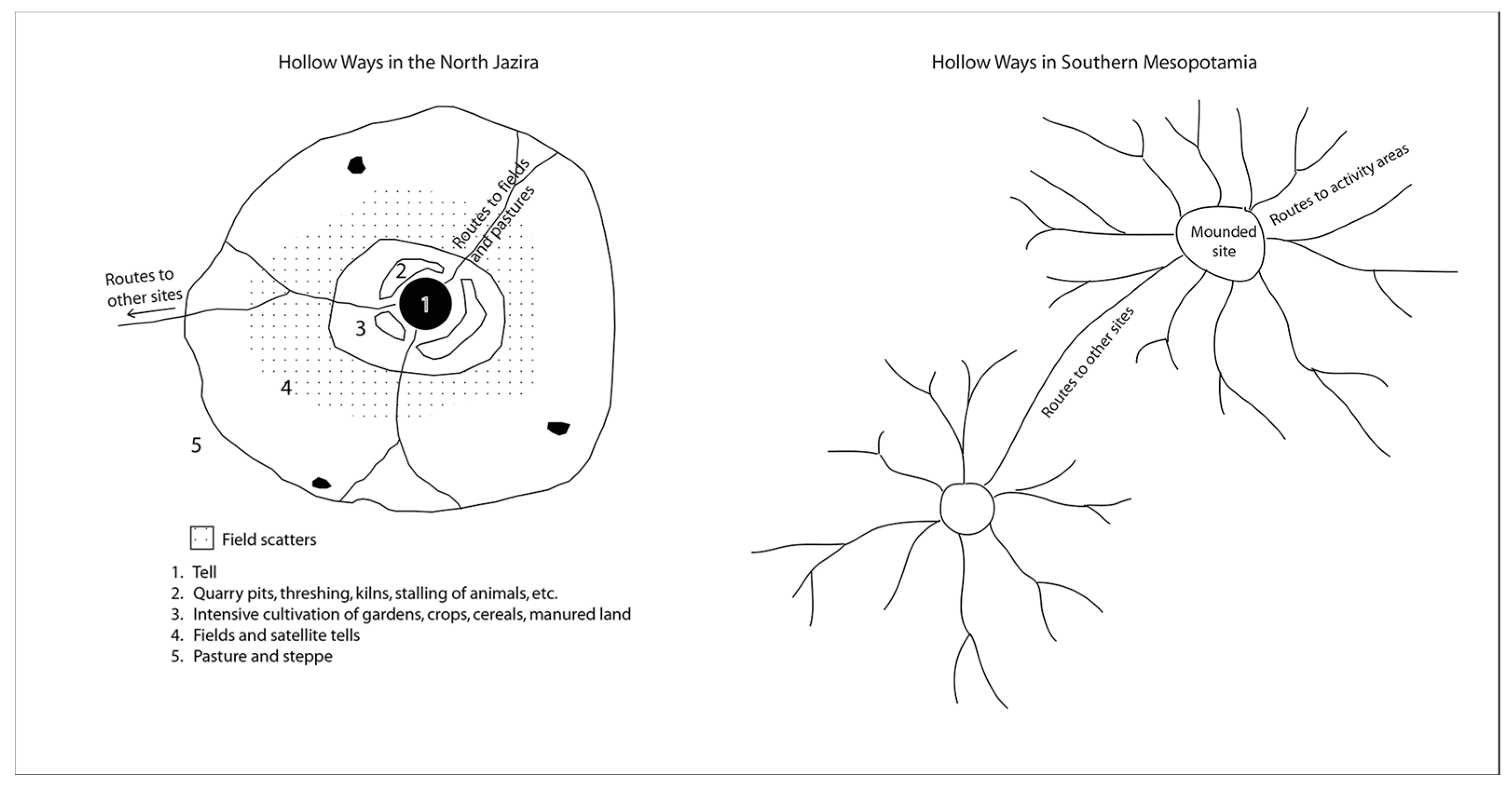
29]. Morphologically, they are also distinctive when they surround sites as branching features radiating outwards (
Figure 3).
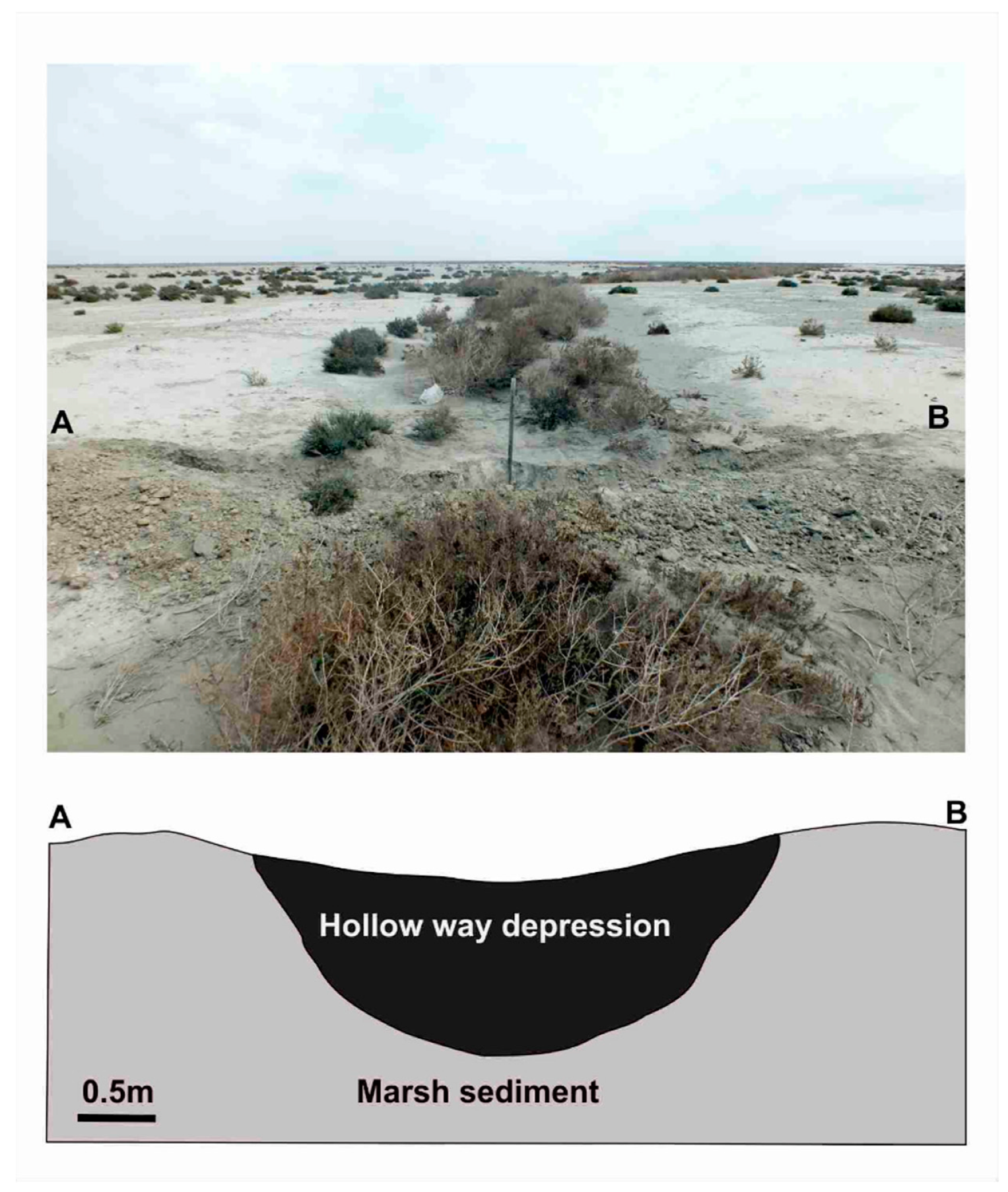
In this study, CORONA imagery and, primarily, QuickBird imagery in Google Earth were used to conduct remote sensing and map the hollow ways directly in Google Earth Pro. In an initial pilot study, remote sensing was conducted systematically in a sweeping fashion across the alluvial plain of southern Iraq using a grid to capture all hollow way segments that might be preserved across the landscape—not just those associated with sites. This approach was abandoned, however, because of its inefficiency and a very high error rate when the features were ground-truthed. In every case, the potential hollow way features located away from sites were found to be buried canals or old river segments when visited on the ground. Away from sites, both features (hollow ways and buried canals) can be linear, short, and straight, with a slight depression through the center that captures water and appears darker from the increased moisture and vegetation. The mapping of old canals is important and continues, but it was not the aim of this research. Instead, the decision was made to systematically search for hollow ways around sites where their radial morphology makes them easier to identify. When these radial features nearly identical to known hollow ways elsewhere across the region were compared with known canals, it became clear that hollow ways can be distinguished from water channels/canals by their relatively shallow depth and lack of levees (
Figure 4 and
Figure 5). The levees alongside water channels/canals in the Southern Mesopotamia can be 2–4 meters in height (see the work of [
30] (p. 206). The hollow ways presented in this paper were mapped within Google Earth Pro using this revised method of remote sensing survey, searching exclusively in the areas around known sites. No grid was used at this stage. Instead, digitized copies of maps from
Land Behind Baghdad,
Uruk Countryside, and
Heartland of Cities, as well as an open source Google Earth file of sites across the region, were loaded into Google Earth [
31,
32,
33,
34]. All sites were examined for hollow ways sequentially from the different sources and any hollow ways found were traced. At the end of each week over a period of several months, all of the newly mapped hollow ways were located on the ground using GPS and ground-truthed. With the exception of those located underwater, the physical characteristics of each hollow way were checked to ensure it is not a modern landscape feature. Additionally, in Iraq, it is customary to approach local property owners, briefly explain the ongoing research, and ask permission to examine any archaeology on their property. Often, this elicits oral histories about the area, sometimes aided by additional local informants drawn into the conversation, and sometimes it is possible to get oral histories about the specific features under investigation. While this revised method yielded a near-perfect success rate, it also had its limitations: isolated segments located away from archaeological sites could be overlooked.
Interestingly, just as some suspected hollow ways in the North Jazira appear to now be paved roads [
15], there is evidence that some modern canals were dug into old hollow ways in Southern Mesopotamia. In some cases, where ground-truthing produced mixed results, local informants explained that they dug the observed canals where there was an existing depression, because it was easier to dig in these locations. In imagery, these modern canals form part (but never all) of the radial pattern of hollow way-like features around known sites (
Figure 6). In other cases, while ground-truthing, it was observed that some of the hollow ways are now used as dirt roads by modern vehicles.
To determine the dates of the hollow ways we found, we used dating by association with both sites and palaeochannels. Adams [
31,
32] and Nissen [
33] conducted large surveys across Southern Mesopotamia that remain the main source of published information about sites and the dates of sites in the region. Additionally, sediment auger coring had previously been carried out by Jotheri in several selected locations across Southern Mesopotamia to investigate the palaeochannels in the area, and some of these results were published in Wilkinson et al. [
35] and Jotheri et al. [
36,
37]. These palaeochannels were dated using accelerator mass spectroscopy (AMS) on shell samples calibrated ages with a 2-sigma error range in calendar years BP [
37] (p. 57).
3. Results
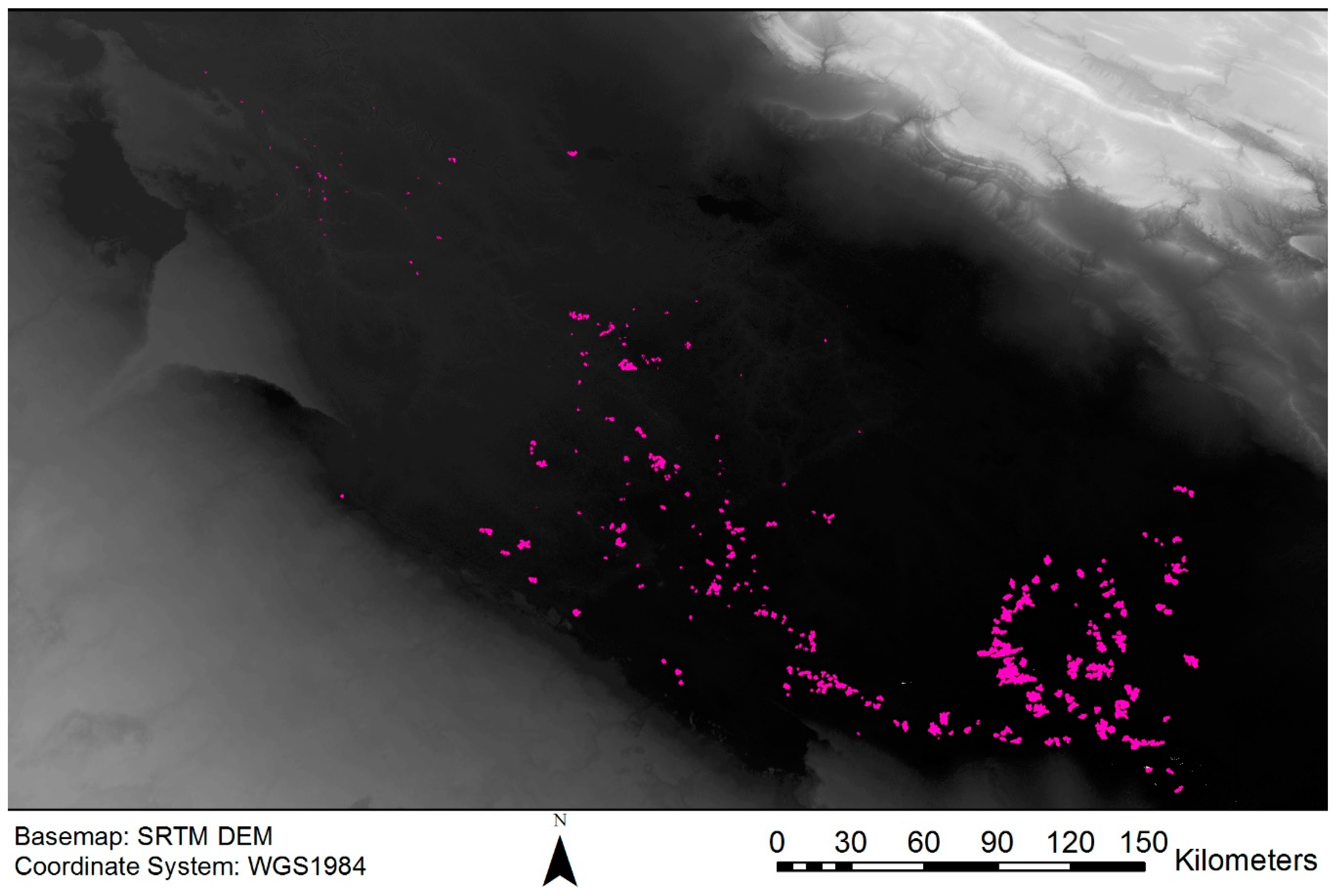
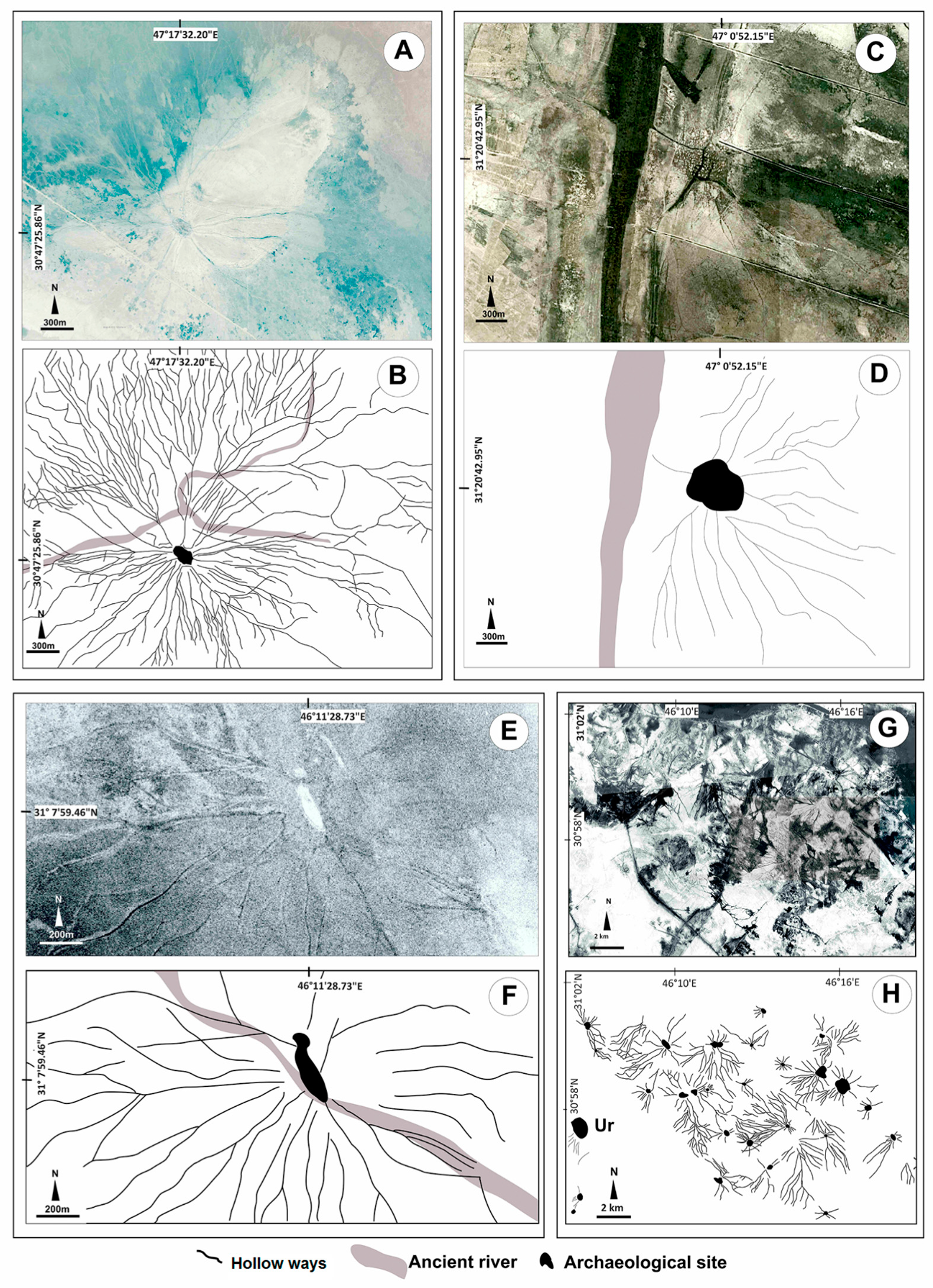
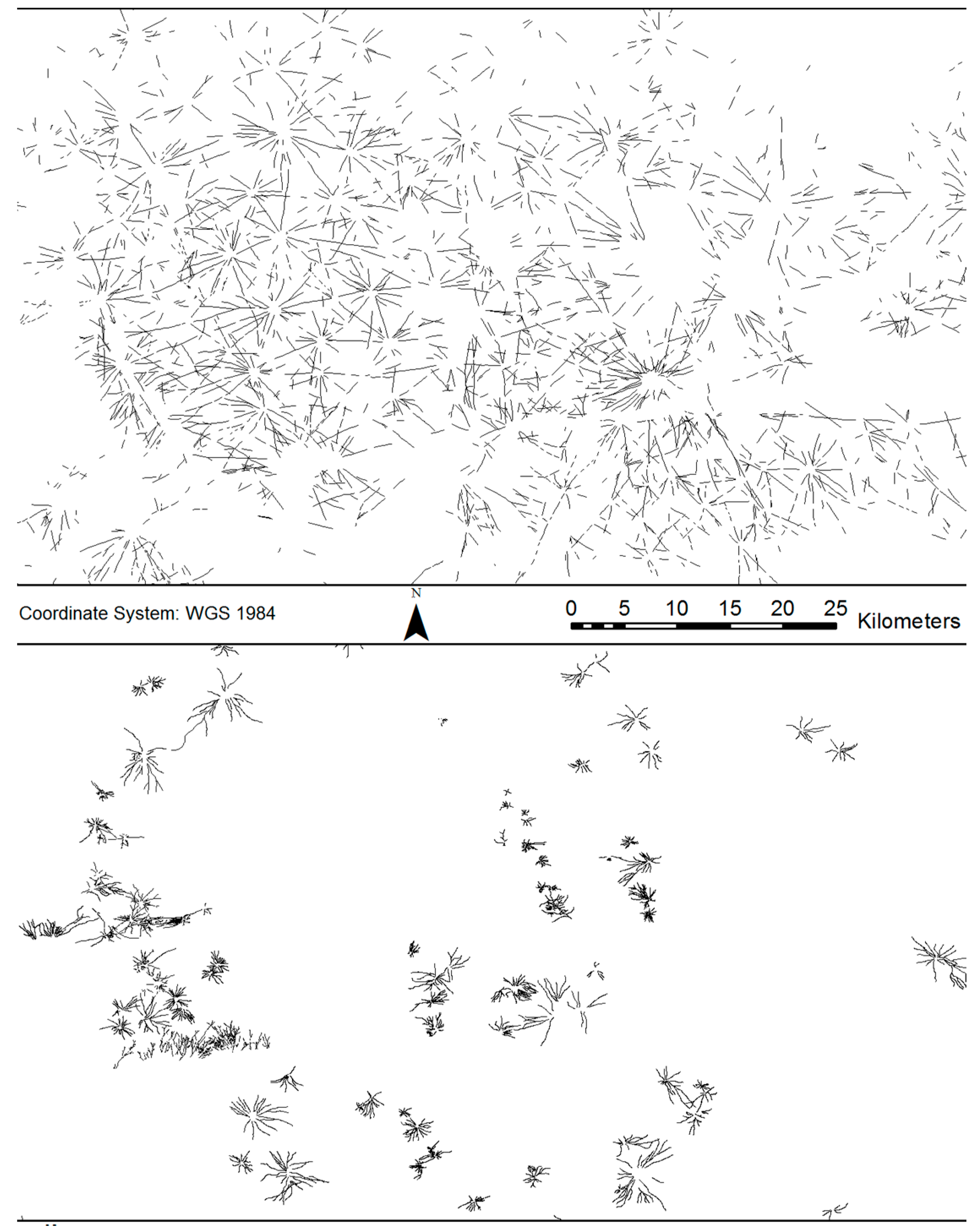
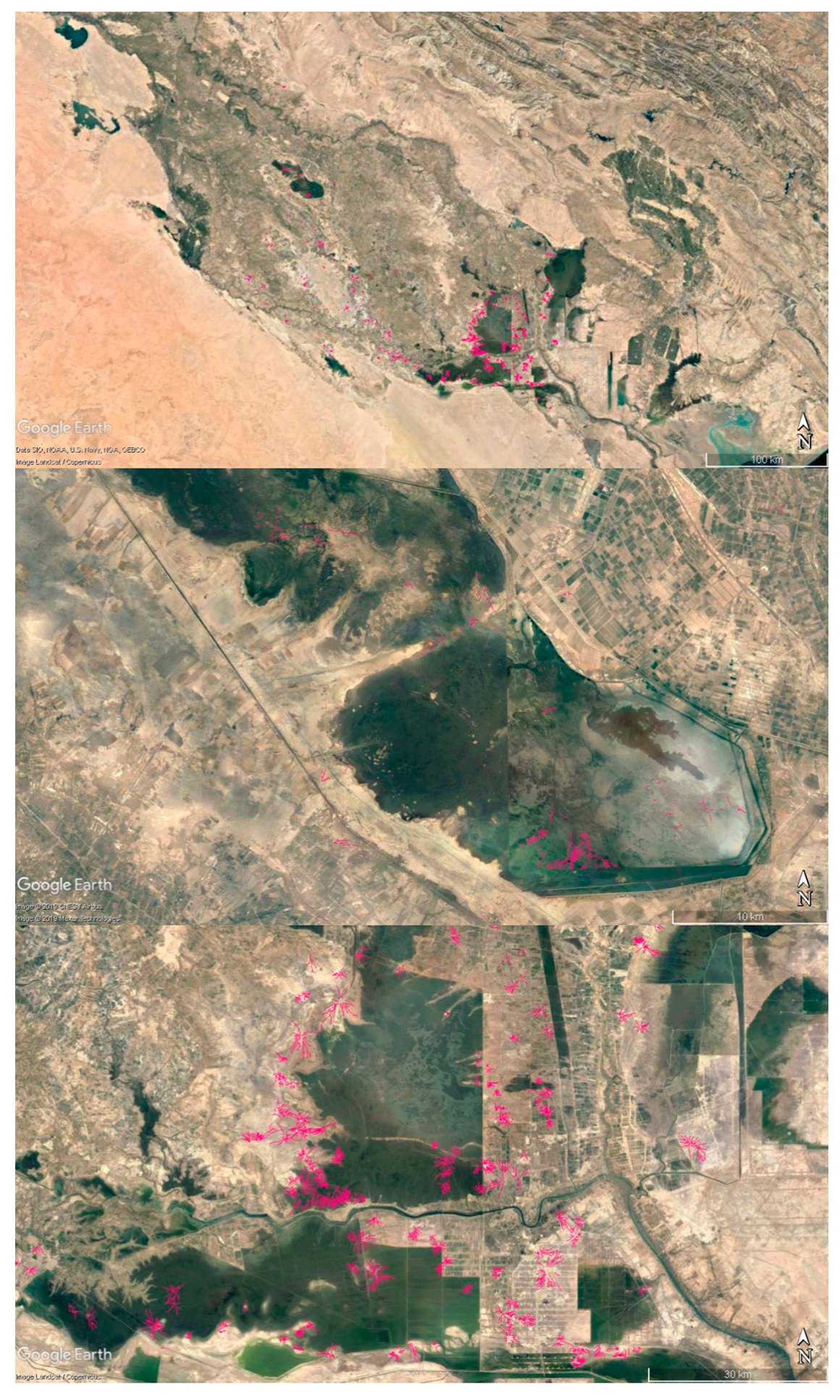
A total of 334 sites surrounded by hollow ways radiating outward from them were identified, and a total of more than six thousand segments of hollow way features were mapped in this survey (
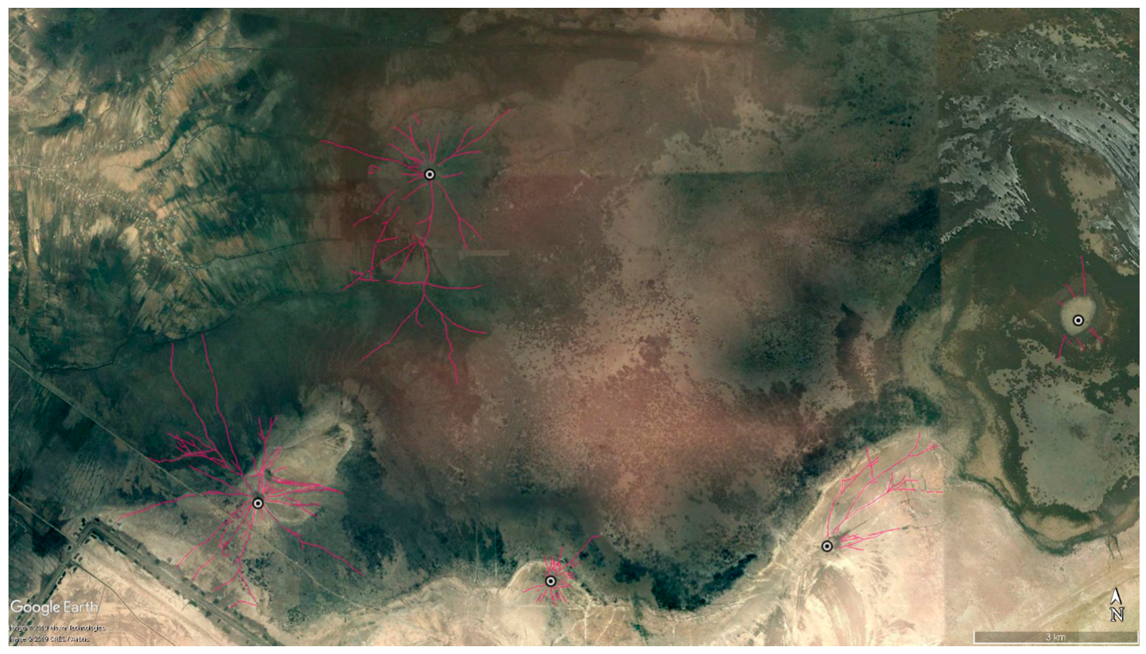
Figure 7). Occasionally, unpublished mounds with hollow ways were discovered in the vicinity of published sites—particularly where published sites were located at the edge of a shallow body of water with submerged hollow ways (
Figure 8).
The hollow ways mapped in this study are similar in character to hollow ways in other regions of the Near East [
6,
7,
8,
16,
17]. Like hollow ways in other parts of the Near East, the hollow ways in Southern Mesopotamia appear as a dark depression line with lighter sides as a result of increased evaporation along the sloping sides (
Figure 9A,C,E,G vs.
Figure 3). Morphologically, they are also similar, radiating out from sites and branching in familiar patterns (
Figure 10). At the same time, on the ground, they lack the levees characteristic of water channels/canals in the alluvium of Southern Mesopotamia; the radial pattern they form around sites is distinctive from the known structure of water channels/canals in Southern Mesopotamia [
30]. These similarities are unsurprising, because the settlements around which they radiate from in Southern Mesopotamia, including within the marshes, are also similar in character to settlements from which hollow ways radiate out in Northern Mesopotamia.
The observed similarities between hollow ways in Southern and Northern Mesopotamia, in particular, are unsurprising, as the settlements from which hollow ways radiate out are also structurally similar in both regions. Across both Southern and Northern Mesopotamia, many settlements remain in static locations with new constructions built overtop older constructions, causing artificially mounded sites called tells. Other studies have argued that within deeper areas of the marshes in Southern Mesopotamia, where the water buffalo breeders live, settlement is different [
38]. In these areas, south of Amara, the argument asserts that settlements within the marshes area frequently occur on naturally occurring mounds, called “turtlebacks”, that rise above flood level, in contrast to the tell-type mounded sites formed by successive layers of occupation [
24]. This may be, but only in the marshes located in the floodplain/deltaic plain where river avulsion is common [
24,
27,
39]. In fact, Tell Oueili, an example Pournelle [
24] provides of a site located on a buried turtleback, is located in precisely this deltaic zone. Further south, the flow of rivers is gradually slowed as they exit the floodplain/deltaic plain into the marshes and lake zone, and finally the estuary zone [
27,
39]. In these latter two zones, river avulsion does not occur due to the very shallow slope of the land and very slow speeds of the rivers. Across the whole of Southern Mesopotamia from the alluvial plain into the estuary zone, sites are consistently observed on the crevasse splays of rivers and submerged sites can be seen to be located along former waterways [
35]. The only historically observed difference in settlement in Southern Mesopotamia is a type of site called
chibasha or
datcha within the marshes of Southern Mesopotamia [
27]. These types of settlements are constructed by layering reed mats and mud to form floating platforms for reed houses [
25] (pp. 30, 32), [
38] (p. 19) and [
40] (p. 1).
While the general appearance in terms of tone, pattern, and shape of the hollow ways in Southern Mesopotamia is similar to those in other regions of the Near East, their size and situation/context are quite different. The hollow ways in Southern Mesopotamia are much narrower than in other regions. In the North Jazira, hollow ways can be 50–120 m wide, but are typically 70–120 m wide [
8,
10,
18]. In the Orontes valley, the hollow ways are up to 15 m in width [
8] (p. 263). By comparison, the hollow ways mapped in Southern Mesopotamia are 2–5 m wide (
Figure 9 and
Figure 10). Another difference is the frequency with which the hollow ways branch or radiate out from sites. In Northern Mesopotamia, the hollow ways are generally single lines with comparatively few branches or sub-routes, while in Southern Mesopotamia, the hollow ways have a much more dendritic pattern with many branches (
Figure 9 and
Figure 10 vs.
Figure 3). Lastly, while Wilkinson [
12] observed three types of hollow way in the North Jazira region of Northern Mesopotamia, in Southern Mesopotamia, we can only distinguish two types of hollow way—those that lead to other settlements, and shorter branches that terminate away from sites (
Figure 11). In an effort to connect these types of hollow ways to specific types of movement, like Wilkinson [
12], we examined the contexts in which they occur.
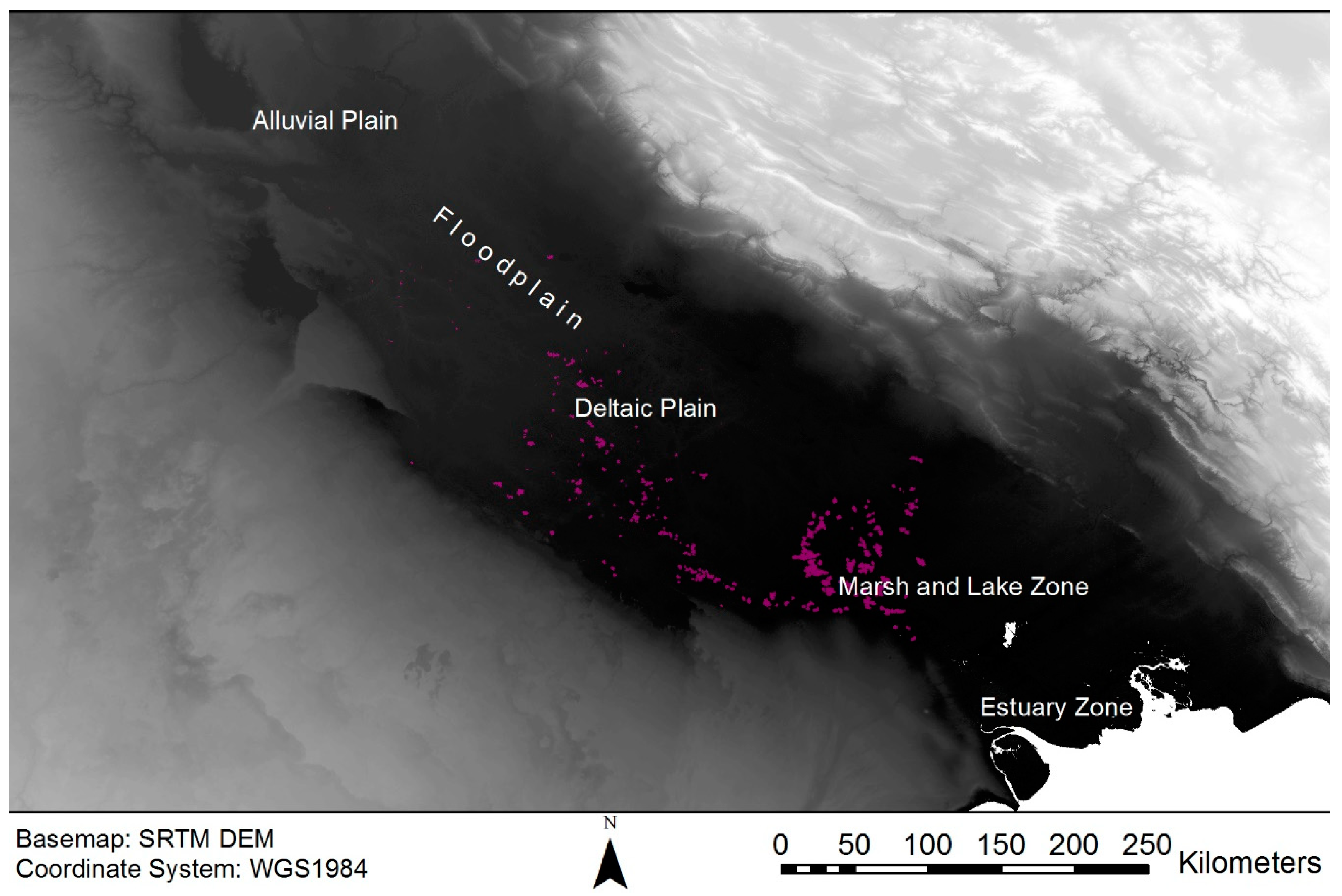
Southern Mesopotamia is divided into distinctive zones, each increasingly flatter than the previous, which alters the energy flow of the rivers through them. Sanlaville [
39] divides Southern Mesopotamia into four zones: the alluvial plain (from Samarra/Ramadi to Hindiya/Hit), the deltaic plain (from Hindiya/Hit to Amara/Nasiriya), the marsh and lake zone (south of Amara/Nasiriya to Basra), and the estuary zone south and east of Basra where the Karun river provides a third source of water (
Figure 12). Tides have historically affected water bodies as far north as Qurnah and Lake Hammar [
39]. West of Basra, acting as a boundary to the marsh area, is the Batin alluvial fan, which formed at the end of the Pliocene or the start of the Pleistocene [
39] (p. 10,
Figure 3). Similarly, Cole and Gasche [
27] (p. 4) define three zones: the floodplain (corresponding to Sanlaville’s alluvial and deltaic plains), the marsh zone (Sanlaville’s marsh and lake zone), and the estuary zone (identical to Sanlaville’s estuary zone).
Prior to the mid-Holocene, the northern shoreline of the Persian Gulf reached Amarah and Nasiriyah, marshes and riverine environments dominated a much greater extent of Southern Mesopotamia [
39,
41,
42,
43]. From the mid-Holocene until the first half of the 20th century, the marshes in Iraq have been situated near Karbala and Najaf, near Birs Nimrud (Borsippa), and south of the modern cities of Amara, Nasiriyah, and Basra [
24,
39] (
Figure 7), [
22,
37]. Since the second half of the 20th century, several large dams were constructed in Turkey, Syria, Iraq, and Iran that have played a direct impact on reducing the amount of water to feed the marshes alongside the Mesopotamian floodplain [
44]. In the 1990s, the Iraqi government launched a major irrigation project that targeted the marshes in the southern area of the Mesopotamian floodplain [
44]. This led to the drainage of the main marshes: Hammar, Chibayish, and the Iraqi portion of the Hawizeh [
45] (p. 39).
The majority of hollow ways mapped in Southern Mesopotamia were located in the marsh/marsh and lake zones, as defined by Sanlaville [
39] and Cole and Gasche [
27], with many more found in Sanlaville’s [
39] deltaic plain zone. Relatively few segments were found north of the deltaic plain and none were located in the estuary zone. Within the deltaic plain and marsh zones, the hollow ways are concentrated within former marshland, as mapped by Buringh [
46], and in the shallow water of current marshland (
Figure 13 and
Figure 14). Particularly dense concentrations of hollow ways are found within the famous Ahwar (marshlands) of Southern Iraq that were drained in the 20th century, but are now a UNESCO World Heritage Site.
The contextual evidence, in particular, the strong, positive correlation between these newly mapped hollow ways and either current or former marsh areas (as mapped by Buringh [
46]), in Southern Mesopotamia provides tantalizing evidence that these are the archaeological traces of the former ‘water passages’ through dense reeds mentioned by Pournelle [
24] and Al-Dafar [
25], and observed ethnographically by Tareq Rajab in the 1960s [
27]. On this basis, we associated the two types of hollow way to two types of travel that would be typical in the marshes. The first type of hollow way is those that connect sites and corresponds to travel between sites. In some cases, there is complete preservation of this (for example, see the lower image in
Figure 10). The second type of hollow way, the many dendritic branches that occur, most likely represent travel to activity areas for cutting reeds or fishing.
The possibility that boats caused the formation of the hollow ways in Southern Mesopotamia is unprecedented, but not entirely unsurprising given the known prevalence of boats and boat travel in Southern Mesopotamia. It is well established that the network of water channels in Southern Mesopotamia not only provided irrigation to the floodplain, but also doubled as a transport network for boats [
31,
47]. Where both overland and water transport were options, it has been demonstrated that boat transport would have been far more economical in the past in terms of both time and physical ease [
48] (pp. 57–61). Correspondingly, Adams and Nissen [
33] noticed from settlement patterning in Southern Mesopotamia that the watercourses were probably used for travel rather than shortest distance overland routes [
33] (p. 19). Initially, these appear to have been natural watercourses, but a noticeable shift occurred sometime between the Early Dynastic I (2900–700 BC) and Early Dynastic II (2700–2600 BC) periods, when the linear patterns of sites become fewer and straighter—indirect evidence for the start of artificial irrigation—although there were probably earlier, smaller modifications to waterways [
31] (p. 35), [
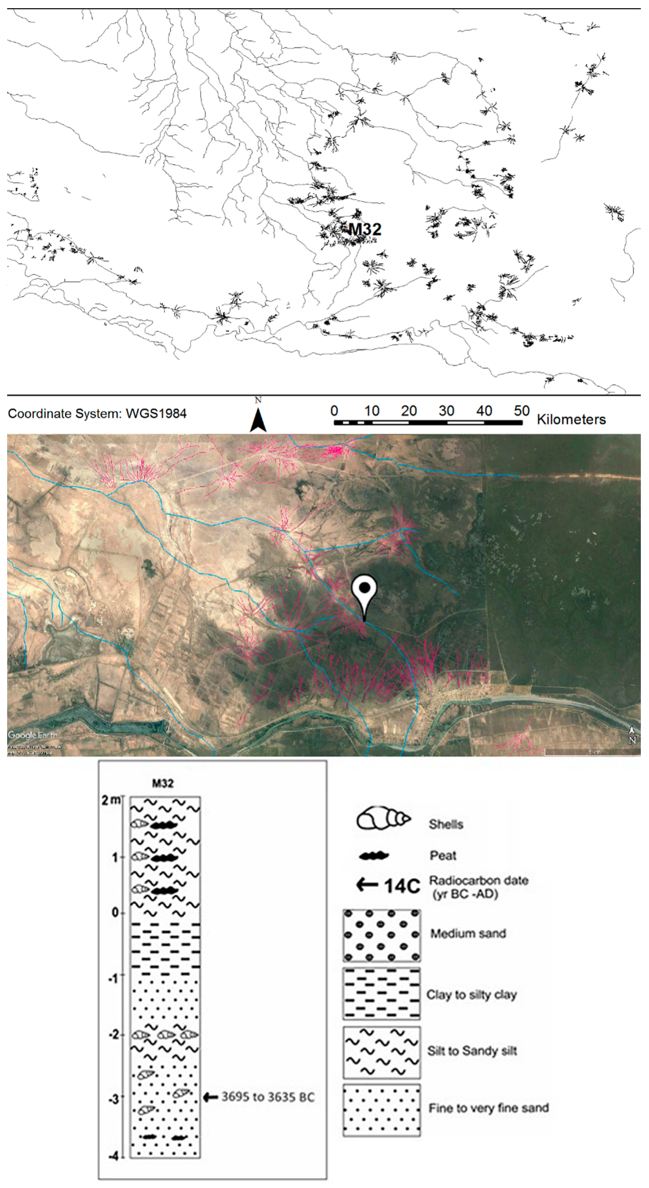
33] (p. 12). In addition to a contextual association between hollow ways and marshlands, many of the mounds found to have hollow ways radiating out from them in Southern Mesopotamia are known archaeological sites or recent human settlements associated with ancient or recent river channels. The dates of the hollow ways were determined by their association with sites along a dated palaeochannel and by their association with dated sites. Three undated and unnamed sites with hollow ways located in the marsh region of Southern Mesopotamia are situated along a palaeochannel that was once a branch of the Lagash channel off the Euphrates river (
Figure 15). A shell (Beta-413642) extracted from 5 m depth in the fill of that palaeochannel was radiocarbon dated to between 3695 and 3635 cal BC [
37] (p. 57), which suggests that the segment of the channel along which the undated sites are situated dates back to at least the Middle Uruk (3800–3300 BC) [
37] (p. 111,
Figure 3 and
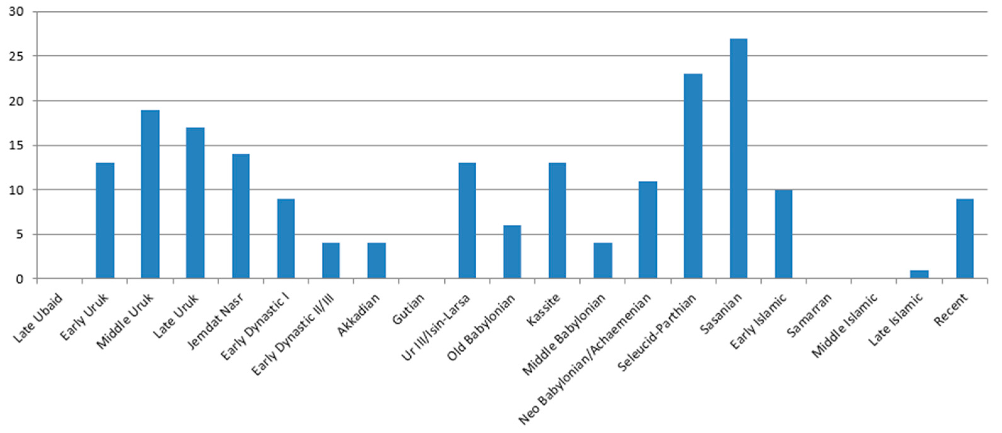
Figure 4). This indicates that the three undated sites and the hollow ways around them could also date back to at least the Middle Uruk (3800–3300 BC). A stronger source of indirect dating evidence, however, is the sites themselves. From the total of 332 sites with hollow ways identified in this study, 69 (just over 20% of the total sample) have published dating information (
Table S1, supplementary material). From this information, a bar graph was produced that quantifies the number of dated sites with hollow ways that were occupied in each period (
Figure 16). The resulting chart shows two peaks: one over the Seleucid–Parthian (300 BC–AD 200) and Sasanian periods (AD 200–640) and a second over the Middle Uruk (3800–3300 BC).
Almost 40 percent of the dated sites with hollow ways (27/69) were in use during the Sasanian period (AD 200–640), while about one-third (23/69) of the dated sites with hollow ways were in use during the Seleucid–Parthian periods (300 BC–AD 200). Earlier, over a fourth (19/69) of the sites with hollow ways were in use during the Middle Uruk (3800–3300 BC). Moreover, not all sites with hollow ways that were active during the Middle Uruk have evidence for activity during the Seleucid–Parthian (11/19) or Sasanian (14/19) periods. Conversely, not all Seleucid–Parthian (15/23) or Sasanian (23/27) sites have evidence for the Middle Uruk (or any of the Uruk period). Together, this suggests two genuine peaks in activity that resulted in hollow ways: one during the Middle Uruk (3800–3300 BC) and a later one that extended over the Seleucid–Parthian (300 BC–AD 200) and Sasanian (AD 200–640) periods. At the same time, it is important to note that the modern village of Hammar also has hollow ways (
Figure 2) and other modern villages associated with rivers have developed hollow way features around them. It is most probable that like hollow ways in other regions, some of the hollow ways in Southern Mesopotamia are much older (the earliest sites with hollow ways in
Table S1 (supplementary material) date back to the Early Uruk (4100-3800 BC), while others are Islamic or even modern.
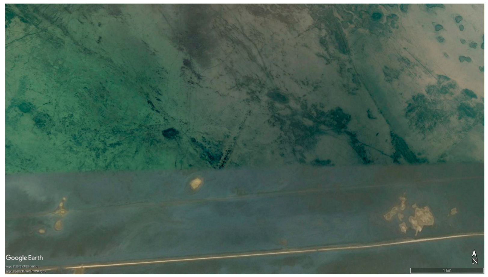
While the more than 6000 segments of hollow ways mapped in this study make Southern Mesopotamia one of the best-preserved landscapes of hollow ways and past movement in the Near East, there is no doubt that more hollow ways are preserved in Southern Mesopotamia than have been mapped in this study. While conducting the remote sensing survey, segments were identified, for example, that appear as if they were trimmed neatly along a line (
Figure 17). This occurs where hollow ways are visible in a more recent, clearer satellite image, but are not visible in the older, adjacent image. As imagery is updated in Google Earth, it will enable the remainder of these truncated hollow ways to be mapped and additional hollow ways to be found.
4. Discussion
No remote sensing survey has identified hollow ways formed or preserved underwater before. Nonetheless, their visibility in Google Earth through shallow water was unmistakable, indistinguishable from their counterparts presently located on dry land except in color owing to the blue tint of water, but the depression of the hollow ways still creates the appearance of a dark line. That hollow ways in Southern Mesopotamia were overwhelmingly found in areas of current or former marshland provides the first evidence that, in the right conditions, boats may cause the formation of hollow ways.
The authors suggest one of two processes could have enabled boats and/or water buffalo, traditionally herded in the marshes of Southern Mesopotamia, to form the hollow ways in this study. The first possibility is that the roots of dense reeds held soil in place, while turbulence from passing boats and/or water buffalo in the water passages allowed for erosion, causing a hollow way (
Figure 18). The second possibility is that roots of the dense reeds allow soil to accumulate, while the passage of boats and/or water buffalo in water passages prevents the build-up of soils, causing the appearance of a hollow way (
Figure 18).
Descriptions of water passage formation from ethnographic sources fit the first hypothesis best:
‘I ask Sadam if these passages through the reedbeds were natural or man-made. He explained that when the water was low the Madan drove buffaloes through the reeds to make a track, which later was kept open by the coming and going of canoes. We came on a dozen buffaloes, submerged in the middle of the waterway, and the man in the bows jabbed at their heads with his pole to try and move them but they paid little attention, even when the canoe scraped over their backs.
“Can the buffaloes touch bottom everywhere here?” I asked.
“Not everywhere, but they have to be able to stand in the water to feed…”’ [
49] (pp. 61–62).
‘They [water buffalo] can range safely and at will. They swim easily in deep water, or lunge their way through the reed-beds, incidentally creating new watery lanes that the tribesmen soon begin to use.’ [
50] (pp. 167–168).
A third possibility, unlikely in the view of the authors, is that the hollow ways formed during periods of desiccation when the marshes were dry. Marshes in the Mesopotamian floodplain are subjected to both permanent and occasional desiccation caused by both natural processes and, sometimes, human interference [
51]. One of the requirements of forming a marsh area is that the lowland area should be confined by a relatively highly elevated topographic feature that acts as a barrier or ridge keeping water inside the depression or the lowland area [
36]. The dimensions of the resulting marsh in terms of width and depth are normally affected by the quantity of the flooded water from the river to the lowland area and the elevation of the surrounded barriers. Climate change and river avulsion, the process by which rivers break their banks and form new channels, are two of the most common natural causes for the formation and desiccation of marshland [
36], [
37] (pp. 170–185) and [
51]. Additionally, channel levees and artificial earth dykes are common barriers as antiquity that can cause or maintain marshes [
27] (pp. 11–14), [
36] and [
37] (pp. 177–181). Meanwhile, the construction of dams, diversion of water resources, and intentional draining of marshes, like that which occurred in the 20th century in southern Iraq, are the anthropogenic factors that cause their desiccation [
36] and [
37] (p. 181).
If the hollow ways formed when the marshes were dry, their morphology is unexpected and strange. Elsewhere in the Near East, hollow ways consistently conform to Wilkinson’s [
12] (pp. 116–120) three types of hollow ways formed by movement associated with the traditional agro-pastoral economy common across the region. Outside of the marshes, Southern Mesopotamia was part of this agro-pastoral economy, with a greater emphasis on agriculture with its irrigated fields than surrounding areas [
52]. Yet, the hollow ways in Southern Mesopotamia do not conform to the types defined by Wilkinson [
12], indicating that they were created by a different pattern of movement or different activities.
The everyday life of people living within the marshes of Southern Mesopotamia depended on fishing and cultivating reeds, which can be made into a variety of products, and later also on herding water buffalo [
25] (pp. 35–39), [
39] (pp. 16–19), [
47] (p. 74), [
48] (pp. 69–70) and [
53]. People in the marshes rely entirely on boats to conduct these tasks and for transportation. Over time, preferred paths form in the water, through the reeds [
40]. These resulting water passages become the routes used to drive water buffalo inside the marshes, sheep around the shorelines to pasture, and for travel to other sites and activity areas for harvesting reeds and fishing (see the work of [
24] (pp. 13–25, Figures 1.2, 1.3)). The movement of fishing or cutting/collecting reeds from a boat within a marsh is far less constrained than the walking between agricultural field boundaries observed elsewhere that prevented people and any animal flocks from branching outward onto side paths until they reach open pasture [
12]. The highly dendritic, branching pattern of the Southern Mesopotamian hollow ways seems more consistent with marsh activities than agro-pastoral activities. Rather, the discovery of hollow ways in the marshes of the deltaic and marsh regions of Southern Mesopotamia likely provides the first direct archaeological evidence for the exploitation of marshes over the last 5800 years, and possibly as far back as the Early Uruk (4100–3800 BC).
The interpretation that the hollow ways are the first direct archaeological evidence for the exploitation of marshes and that they date as far back as 4100 BC, as determined by dating through association, fits well with the evidence for boats in Southern Mesopotamia. The earliest depictions and models of boats in Southern Mesopotamia date to the Ubaid period (6500–4100 BC) [
24] (p. 10), [
54,
55] and reed boats, similar to those depicted in archaeological contexts, are known ethnographically from the marshes of the 20th century [
40]. Equally, the timing of a potential peak in their formation during the Middle Uruk (3800–3300 BC) coincides with both the emergence of urbanism in Southern Mesopotamia and the last centuries of a period of when it is hypothesized that there were more extensive marshland and more waterways owing to differences in sea level that caused the shoreline of Persian Gulf to extend further north, as well as a generally cooler and moister climate [
49] (pp. 40–63). Both Algaze [
38,
48] (pp. 40–63) and Pournelle [
24,
56] have outlined the important and advantageous roles both increased water channels and a high diversity of ecosystems, including marshlands, would have played in the emergence of cities in southern Mesopotamia—a hypothesis first put forward by Joan Oates [
57]. The end of this peak corresponds to a period both when the extent of marshland would have been receding to their modern, natural (pre-1970s) extent [
58] and when nascent city-states increasingly began excavating irrigation channels [
35,
59].
The connection between hollow ways as marsh features in Southern Mesopotamia and their dates has implications for the dates of marsh formation across the region. It has just been discussed how a potential peak in the formation of hollow ways during the Middle Uruk corresponds to a time when it is known that marshland was more extensive in Southern Mesopotamia. More generally, however, if the hollow ways formed in marsh conditions, then the date of hollow way formation around any given site in this region is dependent on (but not necessarily determined by) the date of marsh formation around that site. The formation and reuse of hollow ways may have been repeated whenever floods occurred and reeds grew. As the marshes of Southern Mesopotamia were subjected to frequent flooding and desiccation [
36], the hollow ways surrounding a site could have several ages of formation.
Table S1 (supplementary material) and
Figure 16 indicate two peaks of activity: the peak during the Middle Uruk, but also another during the Seleucid-Parthian and Sasanian periods. Were the Seleucid–Parthian and Sasanian periods also a time of more extensive marshland in Southern Mesopotamia or a period of particularly intensive use of existing marshland resources?
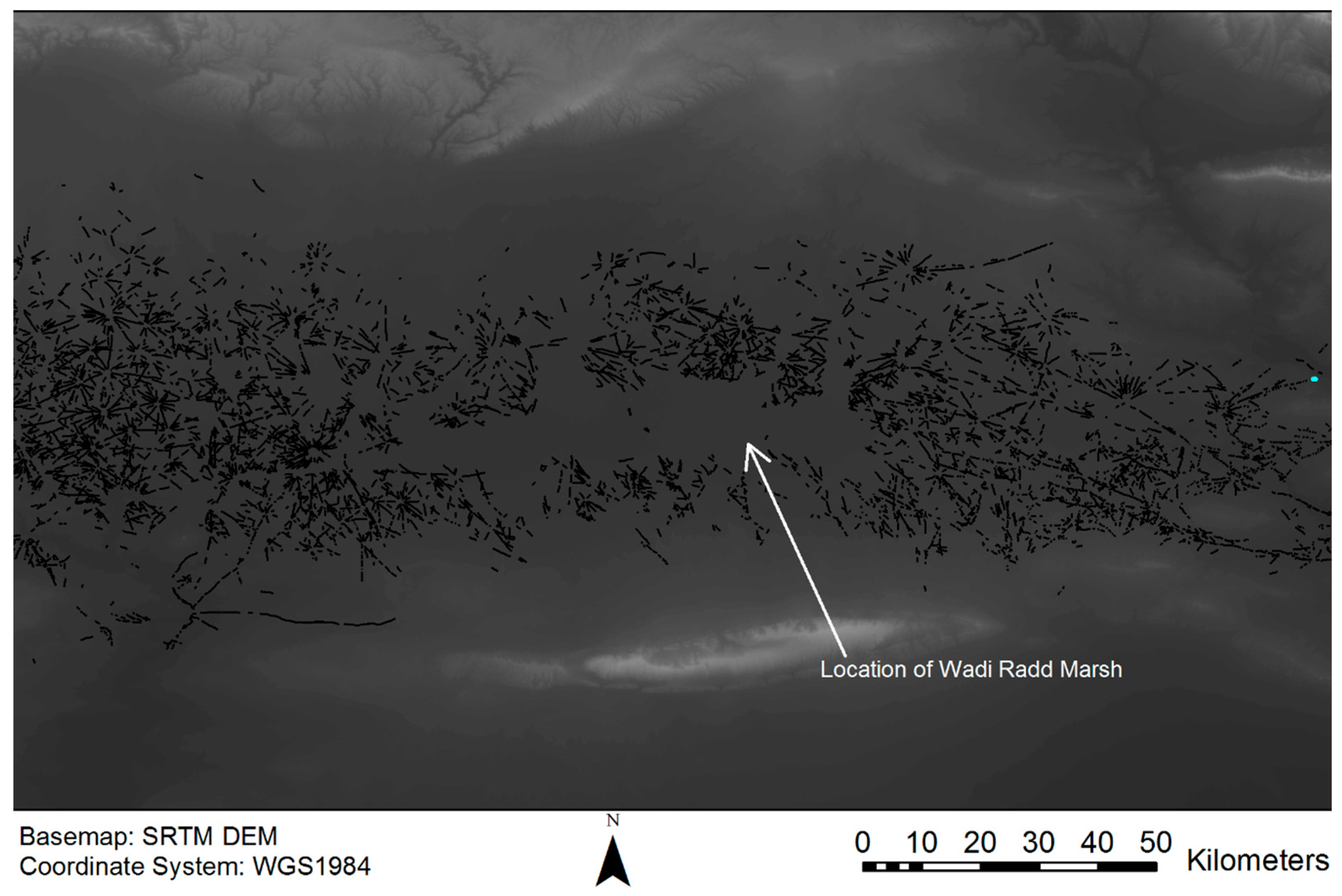
The strong positive correlation between marshes and hollow ways in Southern Mesopotamia also has implications for Northern Mesopotamia, where there is an equally strong negative correlation between marshland and hollow ways. In the North Jazira region of Northern Mesopotamia, one can nearly map the extent of the former Wadi Radd Marsh by the conspicuous gap in hollow ways in the middle of the region where it was once located (
Figure 19). One possible explanation for this gap in the North Jazira could be the accumulation of alluvial sediments over any hollow ways that were once located in the Wadi Radd Marsh. A second possibility is that the marsh, when it was extant, lacked dense reeds so boats did not create defined paths of regular traffic like those observed ethnographically in the south [
40]. A third possibility is that the people living near the Wadi Radd Marsh did not have the same traditions as Southern Mesopotamia of using boats to regularly travel through the marsh to fish and harvest reeds or, later, to herd water buffalo. The North Jazira is better known for agriculture and sheep/goat pastoralism, and settlement along the edge of the Wadi Radd Marsh during the Akkadian period (2350–2150 BC) has been associated with land reclamation for the extensification of agriculture [
60] (p. 60–61) and [
61] (p. 252).
5. Conclusions
The aim of this study was to produce the first map of hollow ways in Southern Mesopotamia from Baghdad to the Persian Gulf. What it revealed was one of the best-preserved landscapes of past movement in the Near East. The current map shows more than six thousand segments of hollow ways around 332 sites in areas of current or former marshland. Only the map of hollow ways in the North Jazira in Northern Mesopotamia is equal in terms of how many hollow ways have been preserved and mapped.
With additional resources and further study, it is expected that many more hollow ways will be found in Southern Mesopotamia. Some hollow ways were found that ended abruptly where a newer image abutted an image that had yet to be updated in Google Earth (
Figure 17). There is no question that as these images are updated, some of the mapped hollow ways from this study will be found to be longer than currently indicated and it is expected that additional segments will appear. Furthermore, it is known that CORONA imagery from the late 1960s to early 1970s is the best satellite imagery for mapping hollow ways in Northern Mesopotamia, better than the imagery available in Google Earth, because the high-quality images pre-date mechanized, industrialized agriculture [
9]. In Southern Mesopotamia, where hollow ways are strongly correlated with current/former marshland, both CORONA and newly digitised U-2 imagery from the late 1950s to early 1960s [
62] could prove useful for mapping additional segments of hollow ways, as both sets of imagery pre-date the draining of the marshes later in the 20th century.
The revised strategy of searching around known archaeological sites in order to map hollow ways led to the surprising result of finding hollow ways and new, undocumented sites, through shallow water. Hollow ways in the Near East, before this study, were land features associated with agro-pastoral activities. No one has ever used remote sensing to map hollow ways through water, nor have hollow ways been found in water environments. In fact, as discussed, the extent of the former Wadi Radd Marsh can be very nearly mapped by a conspicuous gap in hollow ways in the North Jazira region of Northern Mesopotamia. Hollow ways in the Near East and around the world were always found on dry land, representing erosion from the traction of people and/or their animals on land—until now.
The discovery that hollow ways can form and preserve in current/former marshland has important implications for regions where hollow ways are conspicuously absent from these areas, such as the North Jazira in Northern Mesopotamia. Instead, questions must be asked about how the marshes and marsh resources were utilized (or not) by past populations, and why those activities either did not leave traces or those traces were not preserved.
The strong correlation of hollow ways in Southern Mesopotamia with marshes in both the marsh and deltaic zones of the region and their dendritic morphology are best explained as the archaeological traces of ethnographically observed “water passages” observed in marshes with dense reeds. The many branches of the hollow ways are not consistent with the constrained movement of walking between field boundaries to one’s own field or through to pastureland observed in hollow ways in the north. Their narrow widths cannot account for the movement of large flocks of sheep/goat that, once through the agricultural fields, branched out into the open pasture beyond, as those in the north did, forming hollow ways up to 120 m wide. The hollow ways in Southern Mesopotamia are the traces of a different kind of movement, one that produces narrow paths and many branches. The water passages created by boats through dense reeds are narrow, and the movement of boats cutting/collecting reeds or finding good fishing places is unconstrained, free to create many branching paths. The movement of the boats in the open paths effectively creates depressions, while the roots of the surrounding reeds held in soil or even enabled sediment to accumulate. Once people began to herd water buffalo in the marshes, these large animals walking/swimming through these paths would cause further erosion in the underwater sediment.
Hollow ways are the direct traces of past human movement, formed by repeated journeys along the same path. Their morphology provides direct evidence about how people moved (with or without animals) through the landscape: overland and, now, through the shallow waters of marshes in Southern Mesopotamia.
