Snow-Covered Area Retrieval from Himawari–8 AHI Imagery of the Tibetan Plateau
Abstract
1. Introduction
2. Study Region and Data Sources
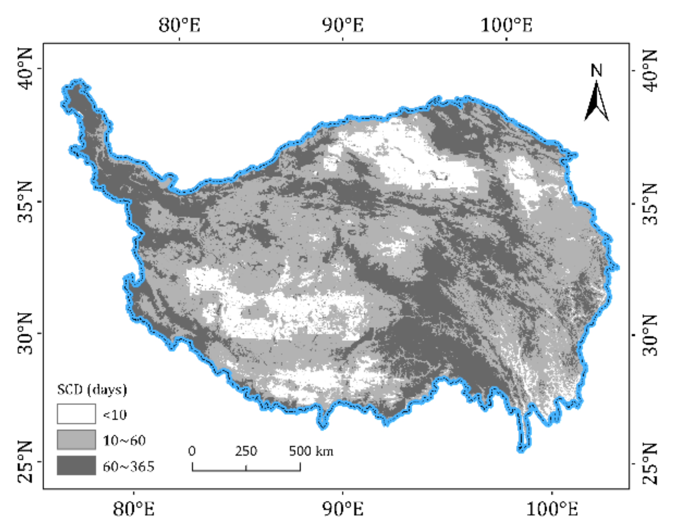
2.1. Study Region
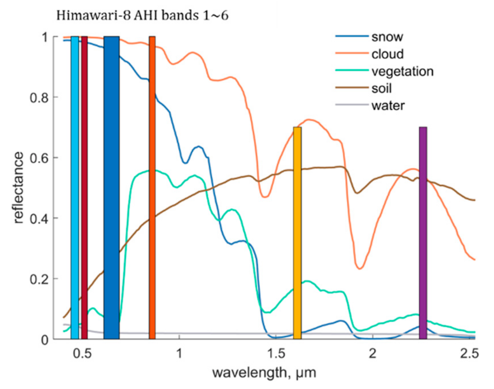
2.2. Himawari–8 Advanced Himiwari Imager (AHI) Data
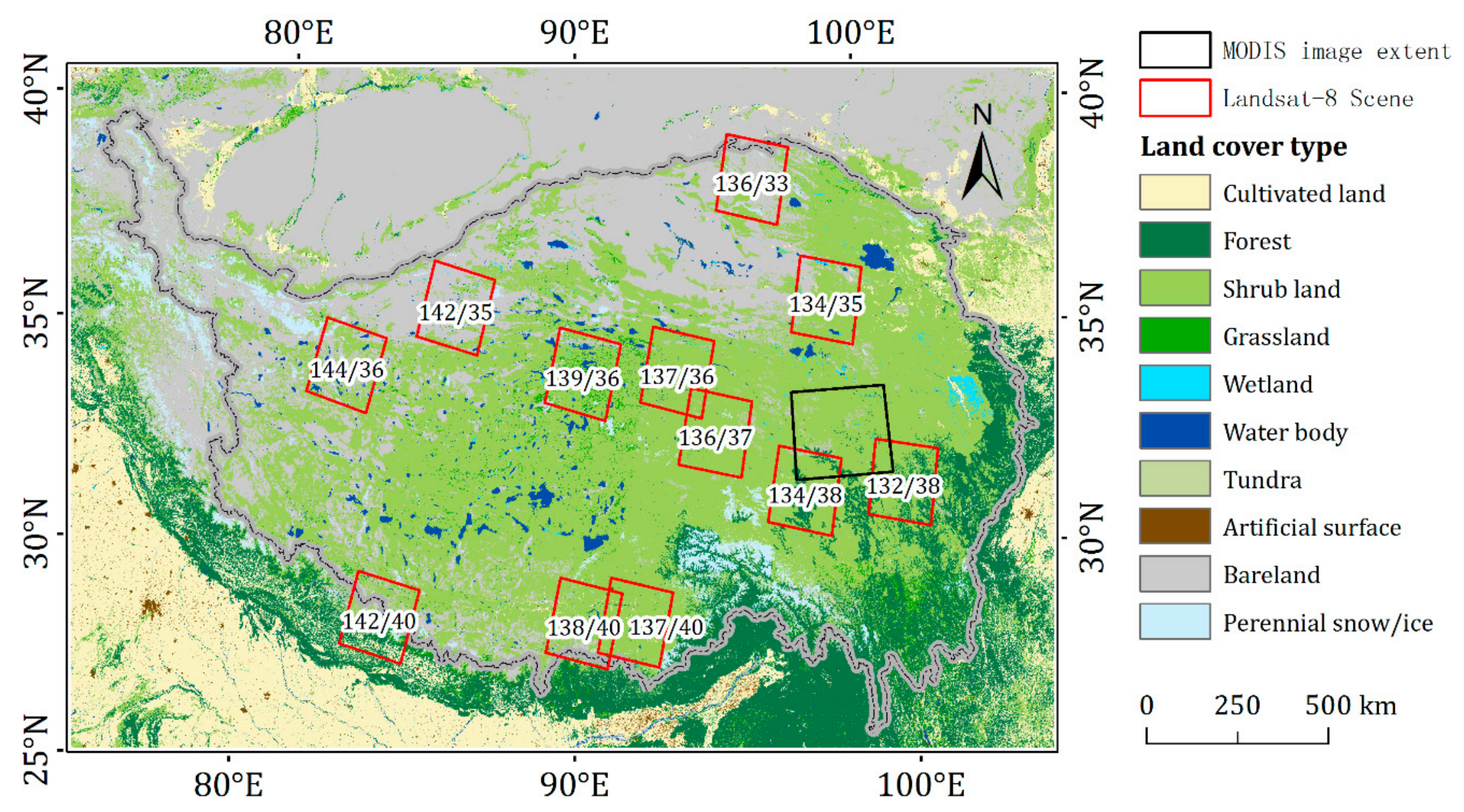
2.3. Landsat–8 Operational Land Imager (OLI) Data
2.4. Terra Moderate Resolution Imaging Spectroradiometer (MODIS) Data
2.5. Auxiliary Data
3. Methodology
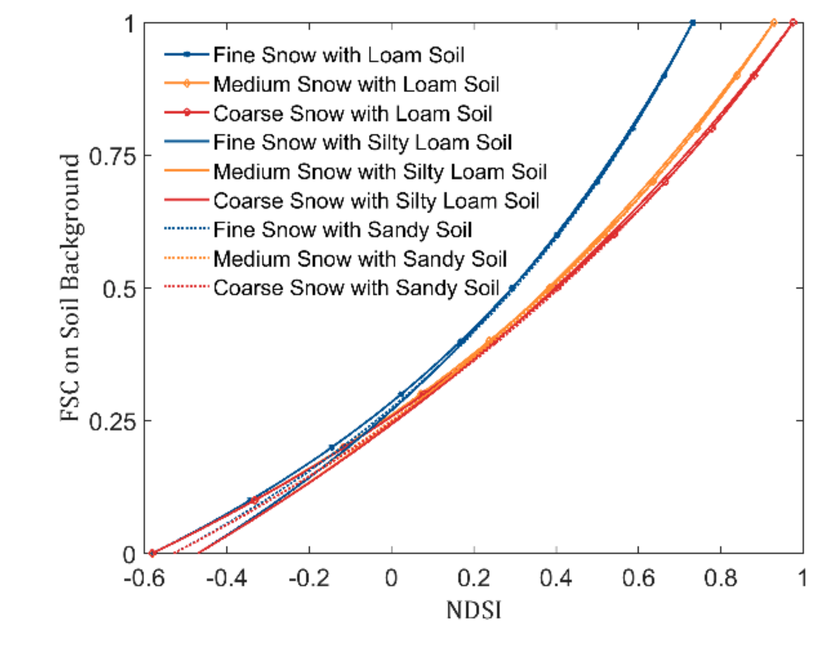
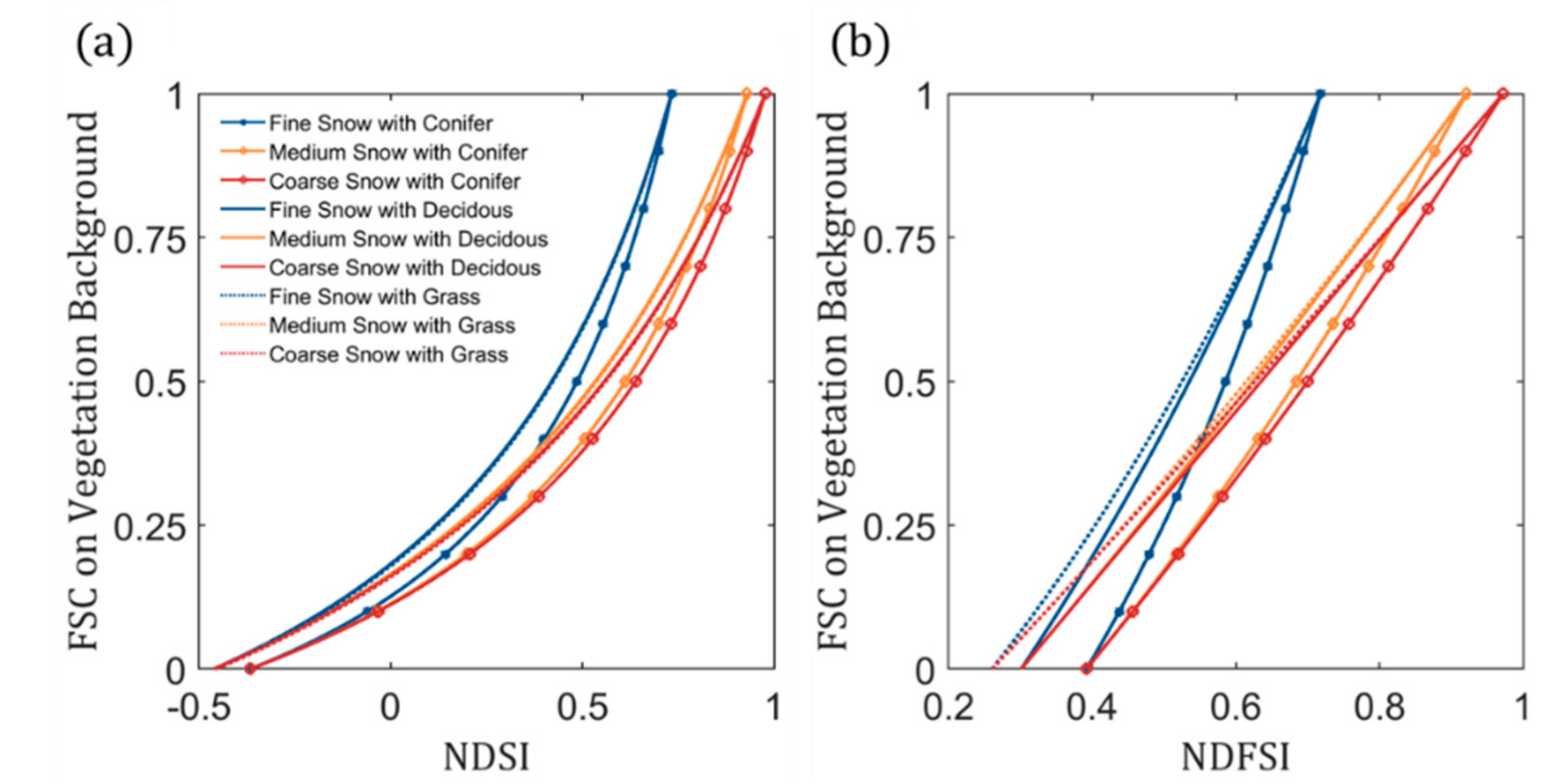
3.1. Indicating Fractional Snow Cover with Snow Indices
3.2. Estimating Fractional Snow Cover with Local Dynamic Snow Indices
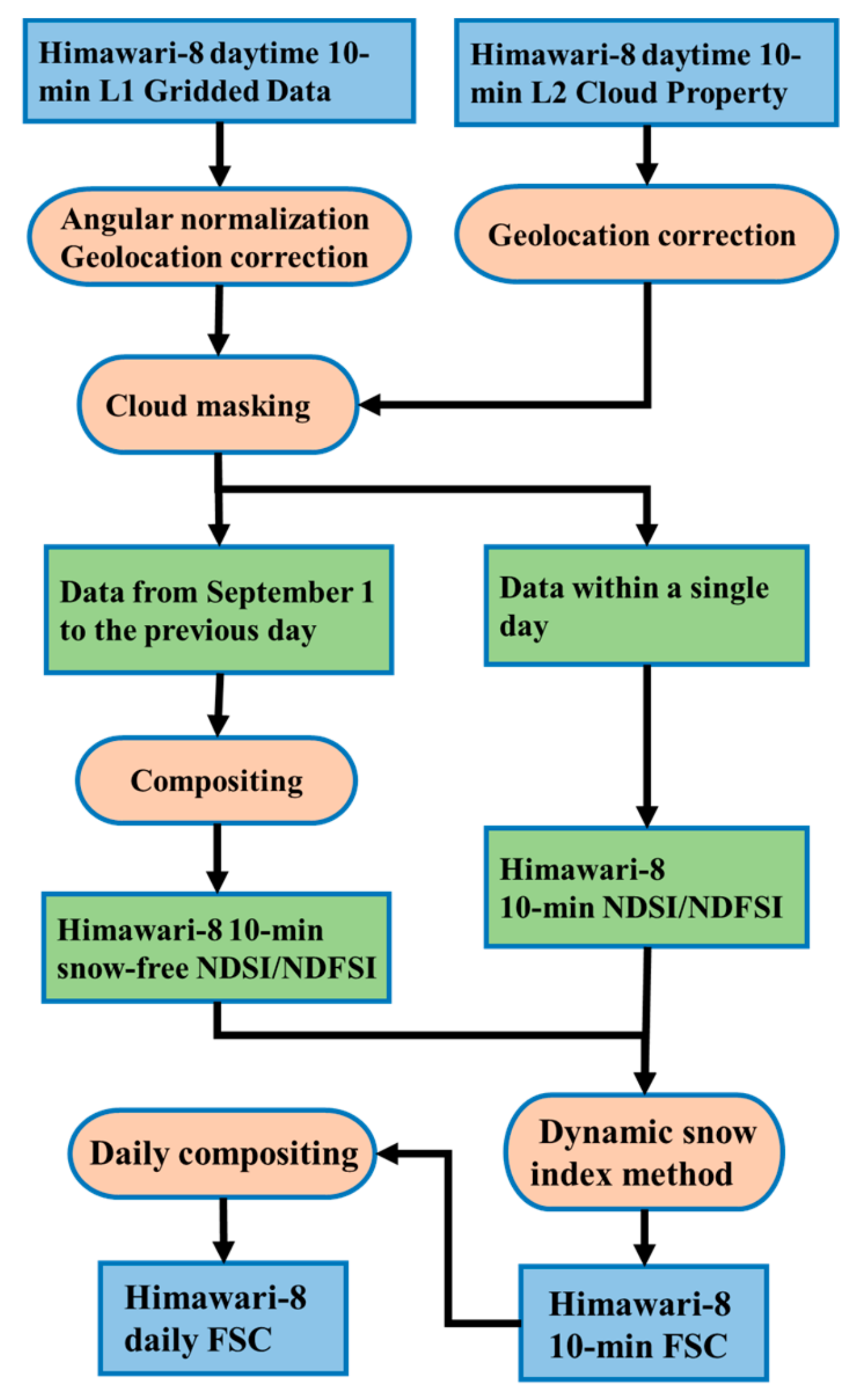
3.3. Himawari–8 Data Preprocessing
3.4. Himawari–8 Snow-Covered Area Retrieval
3.5. Evaluation Metrics
4. Results and Evaluation
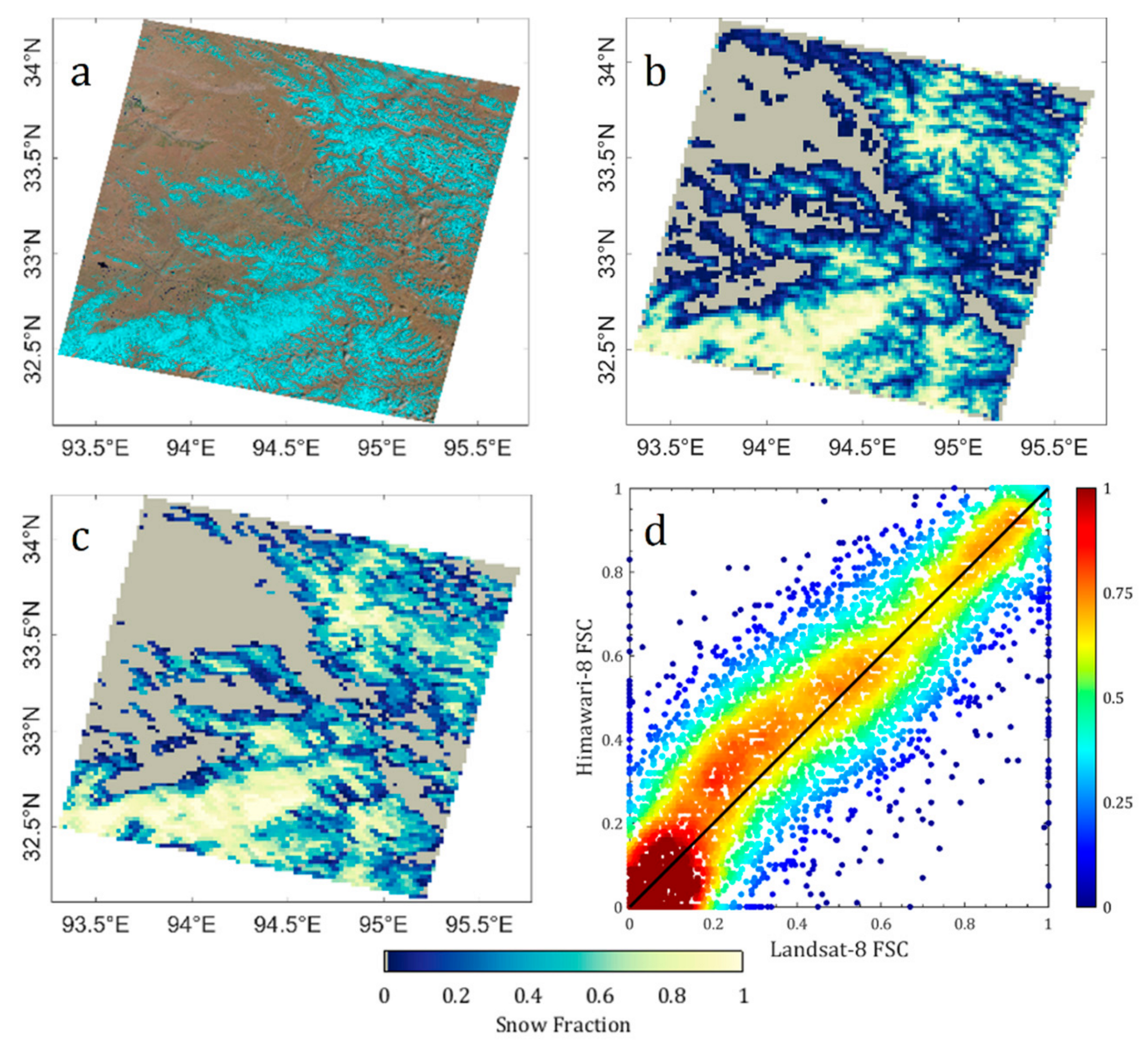
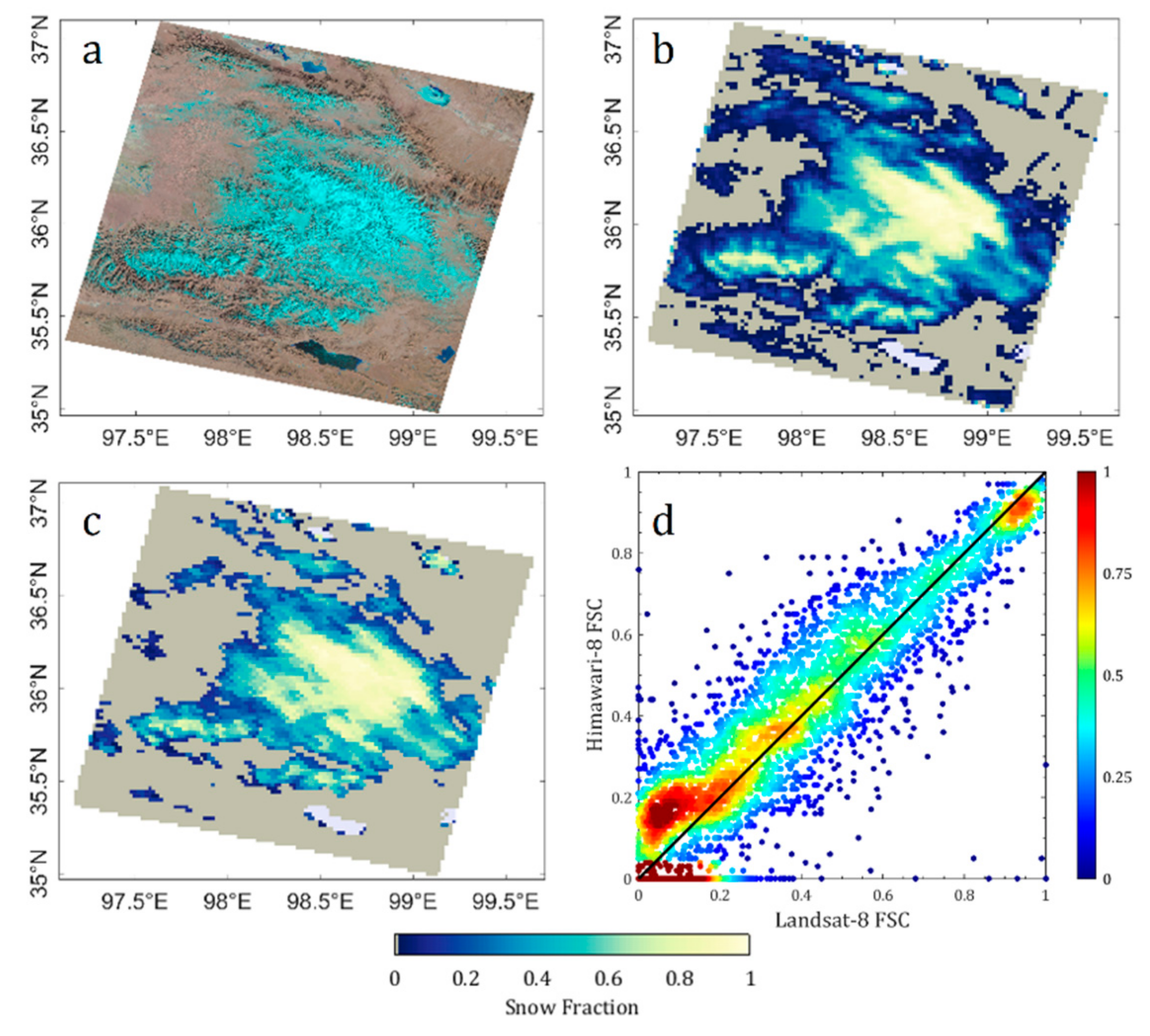
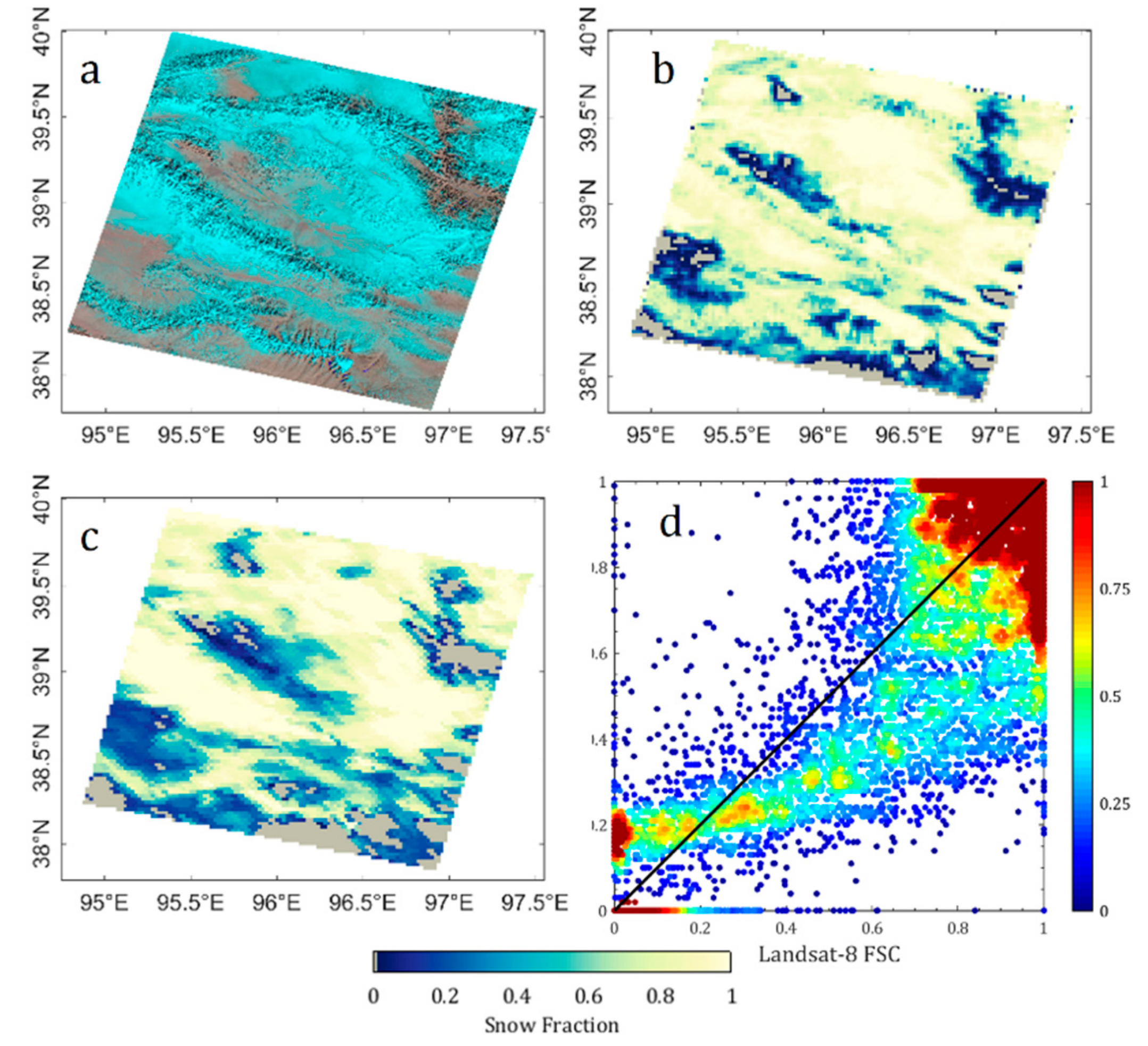
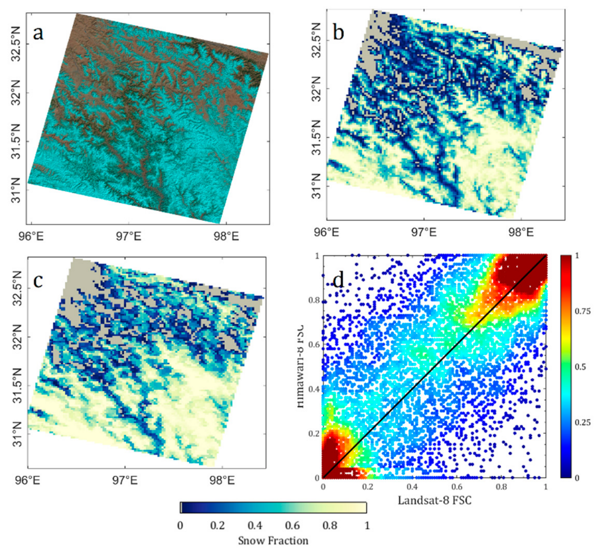
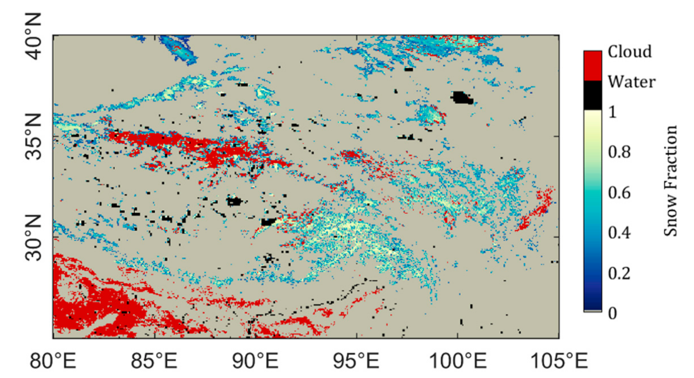
4.1. Evaluation Using Landsat–8 OLI
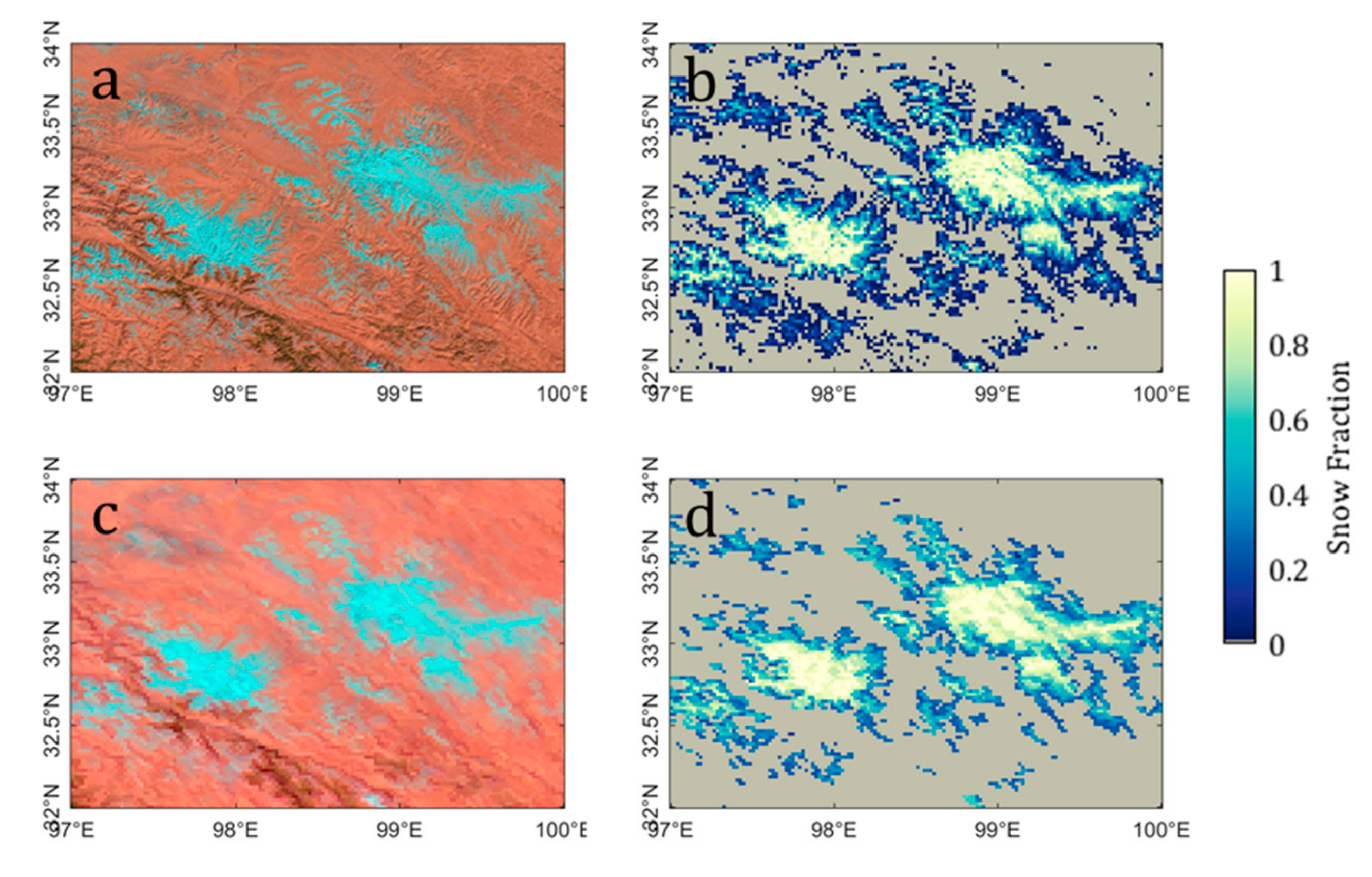
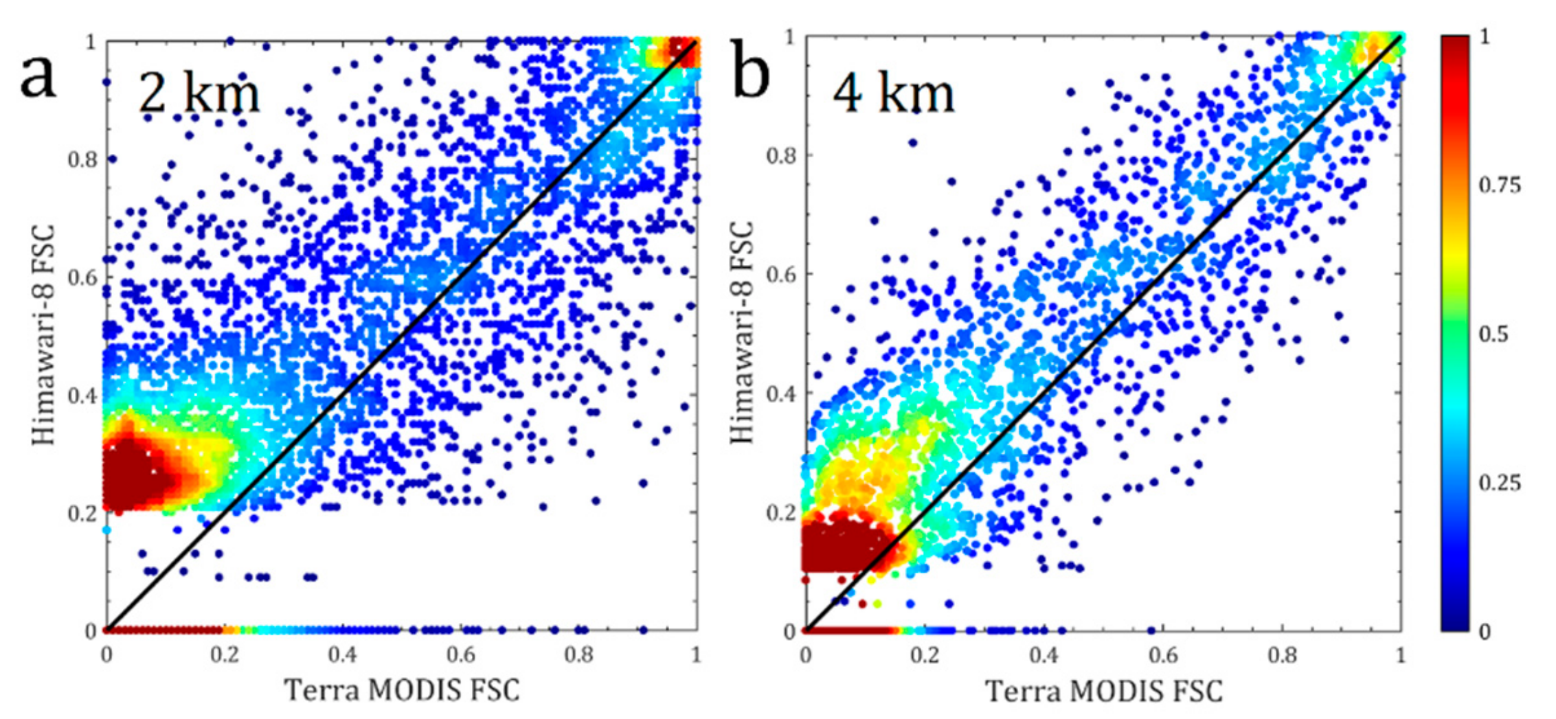
4.2. Evaluation Using Terra Moderate Resolution Imaging Spectrometer (MODIS)
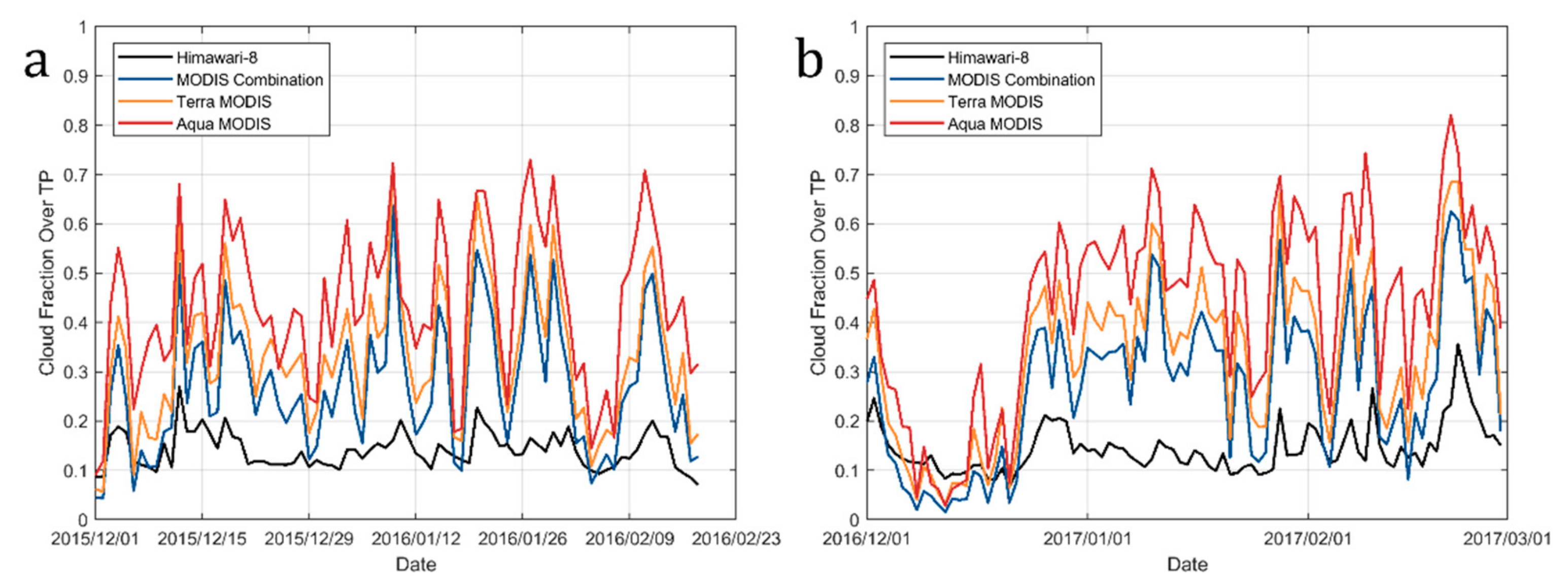
4.3. Cloud Removal Efficiency of Daily Composite Snow-Covred Area
5. Discussion
6. Conclusions
Author Contributions
Funding
Acknowledgments
Conflicts of Interest
References
- Barnett, T.P.; Adam, J.C.; Lettenmaier, D.P. Potential impacts of a warming climate on water availability in snow-dominated regions. Nature 2005, 438, 303–309. [Google Scholar]
- Winiger, M.; Gumpert, M.; Yamout, H. Karakorum–Hindukush–western Himalaya: Assessing high-altitude water resources. Hydrol. Process. 2005, 19, 2329–2338. [Google Scholar]
- Su, F.; Zhang, L.; Ou, T.; Chen, D.; Yao, T.; Tong, K.; Qi, Y. Hydrological response to future climate changes for the major upstream river basins in the Tibetan Plateau. Glob. Planet. Chang. 2016, 136, 82–95. [Google Scholar]
- Zhang, L.; Su, F.; Yang, D.; Hao, Z.; Tong, K. Discharge regime and simulation for the upstream of major rivers over Tibetan Plateau. J. Geophys. Res. Atmos. 2013, 118, 8500–8518. [Google Scholar]
- Bookhagen, B.; Burbank, D.W. Toward a complete Himalayan hydrological budget: Spatiotemporal distribution of snowmelt and rainfall and their impact on river discharge. J. Geophys. Res. Earth Surf. 2010, 115, F03019. [Google Scholar]
- Madan, N.J. Snow ecology: An interdisciplinary examination of snow-covered ecosystems. J. Ecol. 2001, 89, 1097–1098. [Google Scholar]
- Zaitchik, B.F.; Rodell, M. Forward-looking assimilation of MODIS-derived snow-covered area into a land surface model. J. Hydrometeorol. 2009, 10, 130–148. [Google Scholar]
- Hock, R.; Holmgren, B. A distributed surface energy-balance model for complex topography and its application to Storglaciären, Sweden. J. Glaciol. 2005, 51, 25–36. [Google Scholar]
- Wu, T.; Qian, Z. The relation between the Tibetan winter snow and the Asian summer monsoon and rainfall: An observational investigation. J. Clim. 2003, 16, 2038–2051. [Google Scholar]
- Xiao, Z.; Duan, A. Impacts of Tibetan Plateau snow cover on the interannual variability of the East Asian summer monsoon. J. Clim. 2016, 29, 8495–8514. [Google Scholar]
- Zhang, Y.; Li, T.; Wang, B. Decadal change of the spring snow depth over the Tibetan Plateau: The associated circulation and influence on the East Asian summer monsoon. J. Clim. 2004, 17, 2780–2793. [Google Scholar]
- Qian, Y.F.; Zheng, Y.Q.; Zhang, Y.; Miao, M.Q. Responses of China’s summer monsoon climate to snow anomaly over the Tibetan Plateau. Int. J. Climatol. 2003, 23, 593–613. [Google Scholar]
- Li, W.; Guo, W.; Qiu, B.; Xue, Y.; Hsu, P.C.; Wei, J. Influence of Tibetan Plateau snow cover on East Asian atmospheric circulation at medium-range time scales. Nat. Commun. 2018, 9, 4243. [Google Scholar]
- Dozier, J. Spectral signature of alpine snow cover from the Landsat Thematic Mapper. Remote Sens. Environ. 1989, 28, 9–22. [Google Scholar]
- Kaufman, Y.J.; Kleidman, R.G.; Hall, D.K.; Martins, J.V.; Barton, J.S. Remote sensing of subpixel snow cover using 0.66 and 2.1 μm channels. Geophys. Res. Lett. 2002, 29, 1781. [Google Scholar]
- Harrison, A.R.; Lucas, R.M. Multi-spectral classification of snow using NOAA AVHRR imagery. Int. J. Remote. Sens. 1989, 10, 907–916. [Google Scholar]
- Salomonson, V.V.; Appel, I. Estimating fractional snow cover from MODIS using the normalized difference snow index. Remote Sens. Environ. 2004, 89, 351–360. [Google Scholar]
- Painter, T.H.; Rittger, K.; McKenzie, C.; Slaughter, P.; Davis, R.E.; Dozier, J. Retrieval of subpixel snow covered area, grain size, and albedo from MODIS. Remote Sens. Environ. 2009, 113, 868–879. [Google Scholar]
- Sirguey, P.; Mathieu, R.; Arnaud, Y. Subpixel monitoring of the seasonal snow cover with MODIS at 250 m spatial resolution in the Southern Alps of New Zealand: Methodology and accuracy assessment. Remote Sens. Environ. 2009, 113, 160–181. [Google Scholar]
- Hall, D.K.; Riggs, G.A. Accuracy assessment of the MODIS snow products. Hydrol. Process. 2007, 21, 1534–1547. [Google Scholar]
- Wang, X.; Xie, H.; Liang, T. Evaluation of MODIS snow cover and cloud mask and its application in Northern Xinjiang, China. Remote Sens. Environ. 2008, 112, 1497–1513. [Google Scholar]
- Marchane, A.; Jarlan, L.; Hanich, L.; Boudhar, A.; Gascoin, S.; Tavernier, A.; Filali, N.; le Page, M.; Hagolle, O.; Berjamy, B. Assessment of daily MODIS snow cover products to monitor snow cover dynamics over the Moroccan Atlas mountain range. Remote Sens. Environ. 2015, 160, 72–86. [Google Scholar]
- Rittger, K.; Painter, T.H.; Dozier, J. Assessment of methods for mapping snow cover from MODIS. Adv. Water Resour. 2013, 51, 367–380. [Google Scholar]
- Hall, D.K.; Riggs, G.A.; Foster, J.L.; Kumar, S.V. Development and evaluation of a cloud-gap-filled MODIS daily snow-cover product. Remote Sens. Environ. 2010, 114, 496–503. [Google Scholar]
- Morriss, B.F.; Ochs, E.; Deeb, E.J.; Newman, S.D.; Daly, S.F.; Gagnon, J.J. Persistence-based temporal filtering for MODIS snow products. Remote Sens. Environ. 2016, 175, 130–137. [Google Scholar]
- Li, X.; Fu, W.; Shen, H.; Huang, C.; Zhang, L. Monitoring snow cover variability (2000–2014) in the Hengduan Mountains based on cloud-removed MODIS products with an adaptive spatio-temporal weighted method. J. Hydrol. 2017, 551, 314–327. [Google Scholar]
- Dariane, A.B.; Khoramian, A.; Santi, E. Investigating spatiotemporal snow cover variability via cloud-free MODIS snow cover product in Central Alborz Region. Remote Sens. Environ. 2017, 202, 152–165. [Google Scholar]
- Huang, Y.; Liu, H.; Yu, B.; Wu, J.; Kang, E.L.; Xu, M.; Wang, S.; Klein, A.; Chen, Y. Improving MODIS snow products with a HMRF-based spatio-temporal modeling technique in the Upper Rio Grande Basin. Remote Sens. Environ. 2018, 204, 568–582. [Google Scholar]
- Dong, C.; Menzel, L. Producing cloud-free MODIS snow cover products with conditional probability interpolation and meteorological data. Remote Sens. Environ. 2016, 186, 439–451. [Google Scholar]
- Dong, C.; Menzel, L. Improving the accuracy of MODIS 8-day snow products with in situ temperature and precipitation data. J. Hydrol. 2016, 534, 466–477. [Google Scholar]
- Deng, J.; Huang, X.; Feng, Q.; Ma, X.; Liang, T. Toward improved daily cloud-free fractional snow cover mapping with multi-source remote sensing data in China. Remote Sens. 2015, 7, 6986–7006. [Google Scholar]
- Dozier, J.; Painter, T.H.; Rittger, K.; Frew, J.E. Time–space continuity of daily maps of fractional snow cover and albedo from MODIS. Adv. Water Resour. 2008, 31, 1515–1526. [Google Scholar]
- Romanov, P.; Tarpley, D. Enhanced algorithm for estimating snow depth from geostationary satellites. Remote Sens. Environ. 2007, 108, 97–110. [Google Scholar]
- Romanov, P.; Gutman, G.; Csiszar, I. Satellite-derived snow cover maps for North America: Accuracy assessment. Adv. Space Res. 2002, 30, 2455–2460. [Google Scholar]
- Romanov, P.; Gutman, G.; Csiszar, I. Automated monitoring of snow cover over North America with multispectral satellite data. J. Appl. Meteorol. 2000, 39, 1866–1880. [Google Scholar]
- De Ruyter de Wildt, M.; Seiz, G.; Gruen, A. Operational snow mapping using multitemporal Meteosat SEVIRI imagery. Remote Sens. Environ. 2007, 109, 29–41. [Google Scholar]
- Siljamo, N.; Hyvärinen, O. New geostationary satellite-based snow-cover algorithm. J. Appl. Meteorol. Clim. 2011, 50, 1275–1290. [Google Scholar]
- Yang, J.; Jiang, L.; Shi, J.; Wu, S.; Sun, R.; Yang, H. Monitoring snow cover using Chinese meteorological satellite data over China. Remote Sens. Environ. 2014, 143, 192–203. [Google Scholar]
- Wang, G.; Jiang, L.; Wu, S.; Shi, J.; Hao, S.; Liu, X. Fractional snow cover mapping from FY-2 VISSR imagery of China. Remote Sens. 2017, 9, 983. [Google Scholar]
- Bessho, K.; Date, K.; Hayashi, M.; Ikeda, A.; Imai, T.; Inoue, H.; Kumagai, Y.; Miyakawa, T.; Murata, H.; Ohno, T.; et al. An introduction to Himawari–8/9-Japan’s new-generation geostationary meteorological satellites. J. Meteorol. Soc. Jpn. 2016, 94, 151–183. [Google Scholar]
- Qiu, J. China: The third pole. Nature 2008, 454, 393–396. [Google Scholar]
- Zhang, Y.; Li, B.; Zheng, D. Datasets of the boundary and area of the Tibetan Plateau. Acta Geogr. Sin. 2002, 69, 164–168. [Google Scholar]
- Gao, Q.; Guo, Y.; Xu, H.; Ganjurjav, H.; Li, Y.; Wan, Y.; Qin, X.; Ma, X.; Liu, S. Climate change and its impacts on vegetation distribution and net primary productivity of the alpine ecosystem in the Qinghai-Tibetan Plateau. Sci. Total. Environ. 2016, 554–555, 34–41. [Google Scholar]
- Miller, D.J. Grasslands of the Tibetan plateau. Rangelands 1990, 12, 159–163. [Google Scholar]
- Li, P.; Mi, D. Distribution of snow cover in China. J. Glaciol. Geocryol. 1983, 5, 9–18. [Google Scholar]
- Qin, D.; Liu, S.; Li, P. Snow Cover Distribution, Variability, and Response to Climate Change in Western China. J. Clim. 2006, 19, 1820–1833. [Google Scholar]
- Wang, J.; Che, T.; Li, Z.; Li, H.; Hao, X.; Zheng, Z.; Xiao, P.; Li, X.; Huang, X.; Zhong, X.; et al. Investigation on snow characteristics and their distribution in China. Adv. Earth. Sci. 2018, 33, 12–26. [Google Scholar]
- Japan Meteorological Agency. Himawari–8/9 Himawari standard data user’s guide (version 1.3), Version 1.3 ed.; Japan Meteorological Agency: Tokyo, Japan, 2017. [Google Scholar]
- Imai, T.; Yoshida, R. Algorithm theoretical basis for Himawari–8 cloud mask product. Meteorol. Satell. Center Tech. Note 2016, 61, 1–17. [Google Scholar]
- Shi, J. An automatic algorithm on estimating sub-pixel snow cover from MODIS. Quat. Sci. 2012, 32, 6–15. [Google Scholar]
- Hao, S.; Jiang, L.; Shi, J.; Wang, G.; Liu, X. Assessment of MODIS-based fractional snow cover products over the Tibetan Plateau. IEEE J. Sel. Top. Appl. Earth Obs. Remote Sens. 2018, 12, 533–548. [Google Scholar]
- Barsi, J.A.; Lee, K.; Kvaran, G.; Markham, B.L.; Pedelty, J.A. The spectral response of the Landsat–8 operational land imager. Remote Sens. 2014, 6, 10232–10251. [Google Scholar]
- Lee, S.; Klein, A.G.; Over, T.M. A comparison of MODIS and NOHRSC snow-cover products for simulating streamflow using the Snowmelt Runoff Model. Hydrol. Process. 2005, 19, 2951–2972. [Google Scholar]
- Wulf, H.; Bookhagen, B.; Scherler, D. Differentiating between rain, snow, and glacier contributions to river discharge in the western Himalaya using remote-sensing data and distributed hydrological modeling. Adv. Water Resour. 2016, 88, 152–169. [Google Scholar]
- He, Z.H.; Parajka, J.; Tian, F.Q.; Blöschl, G. Estimating degree-day factors from MODIS for snowmelt runoff modeling. Hydrol. Earth. Syst. Sc. 2014, 18, 4773–4789. [Google Scholar]
- Liu, Y.; Peters-Lidard, C.D.; Kumar, S.; Foster, J.L.; Shaw, M.; Tian, Y.; Fall, G.M. Assimilating satellite-based snow depth and snow cover products for improving snow predictions in Alaska. Adv. Water Resour. 2013, 54, 208–227. [Google Scholar]
- Ek, M.B.; Mitchell, K.E.; Lin, Y.; Rogers, E.; Grunmann, P.; Koren, V.; Gayno, G.; Tarpley, J.D. Implementation of Noah land surface model advances in the National Centers for Environmental Prediction operational mesoscale Eta model. J. Geophys. Res. 2003, 108, 8851. [Google Scholar]
- Wang, X.; Xie, H. New methods for studying the spatiotemporal variation of snow cover based on combination products of MODIS Terra and Aqua. J. Hydrol. 2009, 371, 192–200. [Google Scholar]
- Riggs, G.A.; Hall, D.K. MODIS snow products collection 6 user guide. Digit. Media 2015, 66, 1–66. [Google Scholar]
- Salomonson, V.V.; Appel, I. Development of the Aqua MODIS NDSI fractional snow cover algorithm and validation results. IEEE. Trans. Geosci. Remote 2006, 44, 1747–1756. [Google Scholar]
- Amante, C. ETOPO1 1 arc-minute global relief model: procedures, data sources and analysis; NOAA NESDIS: Boudler, CO, USA, 2009. [Google Scholar]
- Chen, J.; Chen, J.; Liao, A.; Cao, X.; Chen, L.; Chen, X.; He, C.; Han, G.; Peng, S.; Lu, M.; et al. Global land cover mapping at 30m resolution: A POK-based operational approach. ISPRS J. Photogramm. 2015, 103, 7–27. [Google Scholar]
- Salisbury, J.W. Johns Hopkins University spectral library and ASTER spectral library. 2002. Available online: http://speclib.jpl.nasa.gov (accessed on 28 June 2004).
- Wang, X.; Wang, J.; Jiang, Z.; Li, H.; Hao, X. An effective method for snow-cover mapping of dense coniferous forests in the Upper Heihe River Basin using Landsat Operational Land Imager data. Remote Sens. 2015, 7, 17246–17257. [Google Scholar]
- Riggs, G.A.; Hall, D.K.; Salomonson, V.V. MODIS snow products user guide to collection 5. Digit. Media 2006, 80, 1–80. [Google Scholar]
- Tanikawa, T.; Aoki, T.; Hori, M.; Hachikubo, A.; Aniya, M. Snow bidirectional reflectance model using non-spherical snow particles and its validation with field measurements. EARSeL eProceedings 2006, 5, 137–145. [Google Scholar]
- Aoki, T.; Aoki, T.; Fukabori, M.; Hachikubo, A.; Tachibana, Y.; Nishio, F. Effects of snow physical parameters on spectral albedo and bidirectional reflectance of snow surface. J. Geophys. Res. Atmos. 2000, 105, 10219–10236. [Google Scholar]
- Kokhanovsky, A.A.; Breon, F.M. Validation of an analytical snow BRDF model using PARASOL multi-angular and multispectral observations. IEEE Geosci. Remote S 2012, 9, 928–932. [Google Scholar]
- Leroux, C.; Deuzé, J.L.; Goloub, P.; Sergent, C.; Fily, M. Ground measurements of the polarized bidirectional reflectance of snow in the near-infrared spectral domain: Comparisons with model results. J. Geophys. Res. Atmos. 1998, 103, 19721–19731. [Google Scholar]
- Roujean, J.-L.; Leroy, M.; Deschamps, P.-Y. A bidirectional reflectance model of the Earth’s surface for the correction of remote sensing data. J. Geophys. Res. Atmos. 1992, 97, 20455–20468. [Google Scholar]
- National Research Council. Prospects and concerns for satellite remote sensing of snow and ice; National Academy Press: Washington, DC, USA, 1989.
- Huang, X.; Liang, T.; Zhang, X.; Guo, Z. Validation of MODIS snow cover products using Landsat and ground measurements during the 2001–2005 snow seasons over northern Xinjiang, China. Int. J. Remote. Sens. 2011, 32, 133–152. [Google Scholar]
- Tahir, A.A.; Chevallier, P.; Arnaud, Y.; Ashraf, M.; Bhatti, M.T. Snow cover trend and hydrological characteristics of the Astore River basin (Western Himalayas) and its comparison to the Hunza basin (Karakoram region). Sci. Total. Environ. 2015, 505, 748–761. [Google Scholar]
- Vermote, E.F.; Tanré, D.; Deuze, J.L.; Herman, M.; Morcette, J.-J. Second simulation of the satellite signal in the solar spectrum, 6S: An overview. IEEE. Trans. Geosci. Remote 1997, 35, 675–686. [Google Scholar]

| Band Number | Wavelength (μm) | Central Wavelength (μm) | Spatial Resolution (km) |
|---|---|---|---|
| 1 | 0.45–0.49 | 0.46 | 1 |
| 2 | 0.50–0.53 | 0.51 | 1 |
| 3 | 0.60–0.68 | 0.64 | 0.5 |
| 4 | 0.84–0.87 | 0.86 | 1 |
| 5 | 1.59–1.63 | 1.6 | 2 |
| 6 | 2.24–2.28 | 2.3 | 2 |
| 7 | 3.78–3.99 | 3.9 | 2 |
| 8 | 5.83–6.65 | 6.2 | 2 |
| 9 | 6.74–7.14 | 7.0 | 2 |
| 10 | 7.25–7.44 | 7.3 | 2 |
| 11 | 8.40–8.78 | 8.6 | 2 |
| 12 | 9.45–9.82 | 9.6 | 2 |
| 13 | 10.2–10.6 | 10.4 | 2 |
| 14 | 10.9–11.6 | 11.2 | 2 |
| 15 | 11.9–12.9 | 12.3 | 2 |
| 16 | 13–13.6 | 13.3 | 2 |
| Band Number | Wavelength (μm) | Central Wavelength (μm) | Spatial Resolution (m) |
|---|---|---|---|
| 1 | 0.44–0.45 | 0.44 | 30 |
| 2 | 0.45–0.51 | 0.48 | 30 |
| 3 | 0.53–0.59 | 0.56 | 30 |
| 4 | 0.64–0.67 | 0.66 | 30 |
| 5 | 0.85–0.88 | 0.87 | 30 |
| 6 | 1.57–1.66 | 1.6 | 30 |
| 7 | 2.11–2.29 | 2.2 | 30 |
| 8 | 0.50–0.68 | 0.59 | 30 |
| 9 | 1.36–1.38 | 1.37 | 30 |
| Land Cover | OLI Path/Row | Acquisition Day | Grid Size | Precision (Binary Metric) | Recall (Binary Metric) | OA (Binary Metric) | RMSE | R2 |
|---|---|---|---|---|---|---|---|---|
| Forest | 132/038 | 2016/02/29 | 0.02° 0.04° | 0.78 0.80 | 0.98 0.99 | 0.83 0.85 | 0.18 0.15 | 0.81 0.88 |
| 134/038 | 2016/02/27 | 0.02° 0.04° | 0.88 0.91 | 0.96 0.96 | 0.87 0.90 | 0.19 0.14 | 0.75 0.83 | |
| Grassland | 136/037 | 2016/10/22 | 0.02° 0.04° | 0.89 0.90 | 0.93 0.95 | 0.89 0.93 | 0.15 0.09 | 0.81 0.91 |
| 134/035 | 2016/01/26 | 0.02° 0.04° | 0.86 0.89 | 0.92 0.92 | 0.92 0.93 | 0.08 0.07 | 0.90 0.96 | |
| 137/036 | 2017/11/01 | 0.02° 0.04° | 0.88 0.91 | 0.95 0.96 | 0.89 0.92 | 0.14 0.10 | 0.86 0.92 | |
| 139/036 | 2017/11/15 | 0.02° 0.04° | 0.82 0.85 | 0.90 0.92 | 0.90 0.92 | 0.16 0.11 | 0.84 0.90 | |
| Barren land | 136/033 | 2016/01/08 | 0.02° 0.04° | 0.95 0.96 | 0.97 0.97 | 0.92 0.92 | 0.20 0.16 | 0.74 0.81 |
| 144/036 | 2016/10/14 | 0.02° 0.04° | 0.85 0.87 | 0.92 0.94 | 0.89 0.90 | 0.18 0.13 | 0.83 0.89 | |
| 142/035 | 2017/10/19 | 0.02° 0.04° | 0.85 0.86 | 0.89 0.91 | 0.92 0.93 | 0.13 0.09 | 0.86 0.92 | |
| Barren land (Himalaya) | 138/040 | 2017/03/13 | 0.02° 0.04° | 0.82 0.82 | 0.97 0.98 | 0.90 0.90 | 0.11 0.09 | 0.90 0.93 |
| 137/040 | 2017/03/22 | 0.02° 0.04° | 0.80 0.85 | 0.94 0.96 | 0.86 0.90 | 0.16 0.12 | 0.81 0.87 | |
| 142/040 | 2017/03/25 | 0.02° 0.04° | 0.85 0.89 | 0.94 0.96 | 0.90 0.93 | 0.19 0.13 | 0.82 0.90 |
© 2019 by the authors. Licensee MDPI, Basel, Switzerland. This article is an open access article distributed under the terms and conditions of the Creative Commons Attribution (CC BY) license (http://creativecommons.org/licenses/by/4.0/).
Share and Cite
Wang, G.; Jiang, L.; Shi, J.; Liu, X.; Yang, J.; Cui, H. Snow-Covered Area Retrieval from Himawari–8 AHI Imagery of the Tibetan Plateau. Remote Sens. 2019, 11, 2391. https://doi.org/10.3390/rs11202391
Wang G, Jiang L, Shi J, Liu X, Yang J, Cui H. Snow-Covered Area Retrieval from Himawari–8 AHI Imagery of the Tibetan Plateau. Remote Sensing. 2019; 11(20):2391. https://doi.org/10.3390/rs11202391
Chicago/Turabian StyleWang, Gongxue, Lingmei Jiang, Jiancheng Shi, Xiaojing Liu, Jianwei Yang, and Huizhen Cui. 2019. "Snow-Covered Area Retrieval from Himawari–8 AHI Imagery of the Tibetan Plateau" Remote Sensing 11, no. 20: 2391. https://doi.org/10.3390/rs11202391
APA StyleWang, G., Jiang, L., Shi, J., Liu, X., Yang, J., & Cui, H. (2019). Snow-Covered Area Retrieval from Himawari–8 AHI Imagery of the Tibetan Plateau. Remote Sensing, 11(20), 2391. https://doi.org/10.3390/rs11202391


