Remote Sensing of Wetland Flooding at a Sub-Pixel Scale Based on Random Forests and Spatial Attraction Models

 ,
, 
 ,
,  ,
, 
 ,
,  and
and
Abstract
1. Introduction
2. Methods
2.1. Principle of SMWF
2.2. SAM-SMWF Algorithm
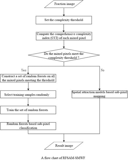
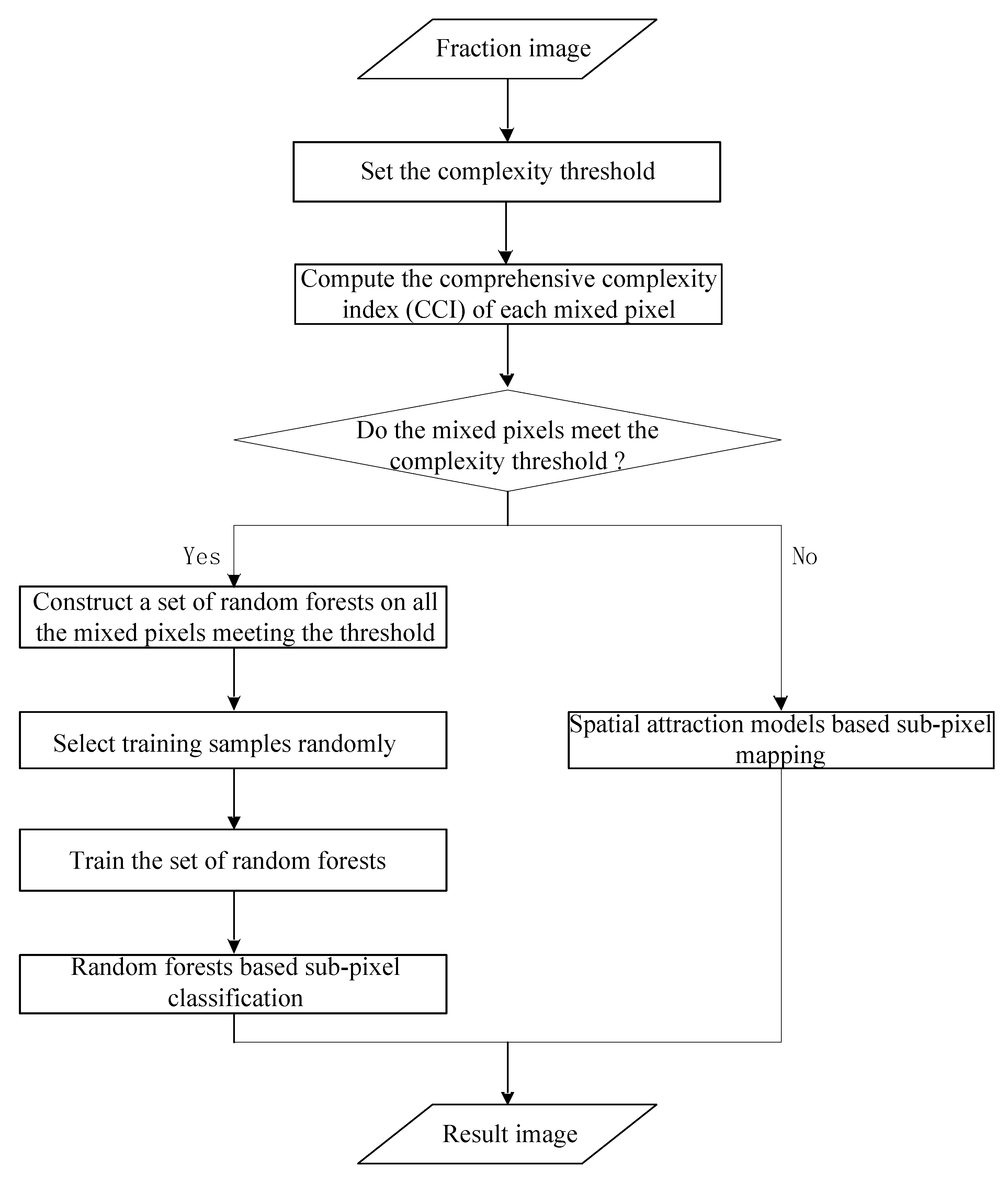
2.3. RFSAM-SMWF Algorithm
3. Case Study
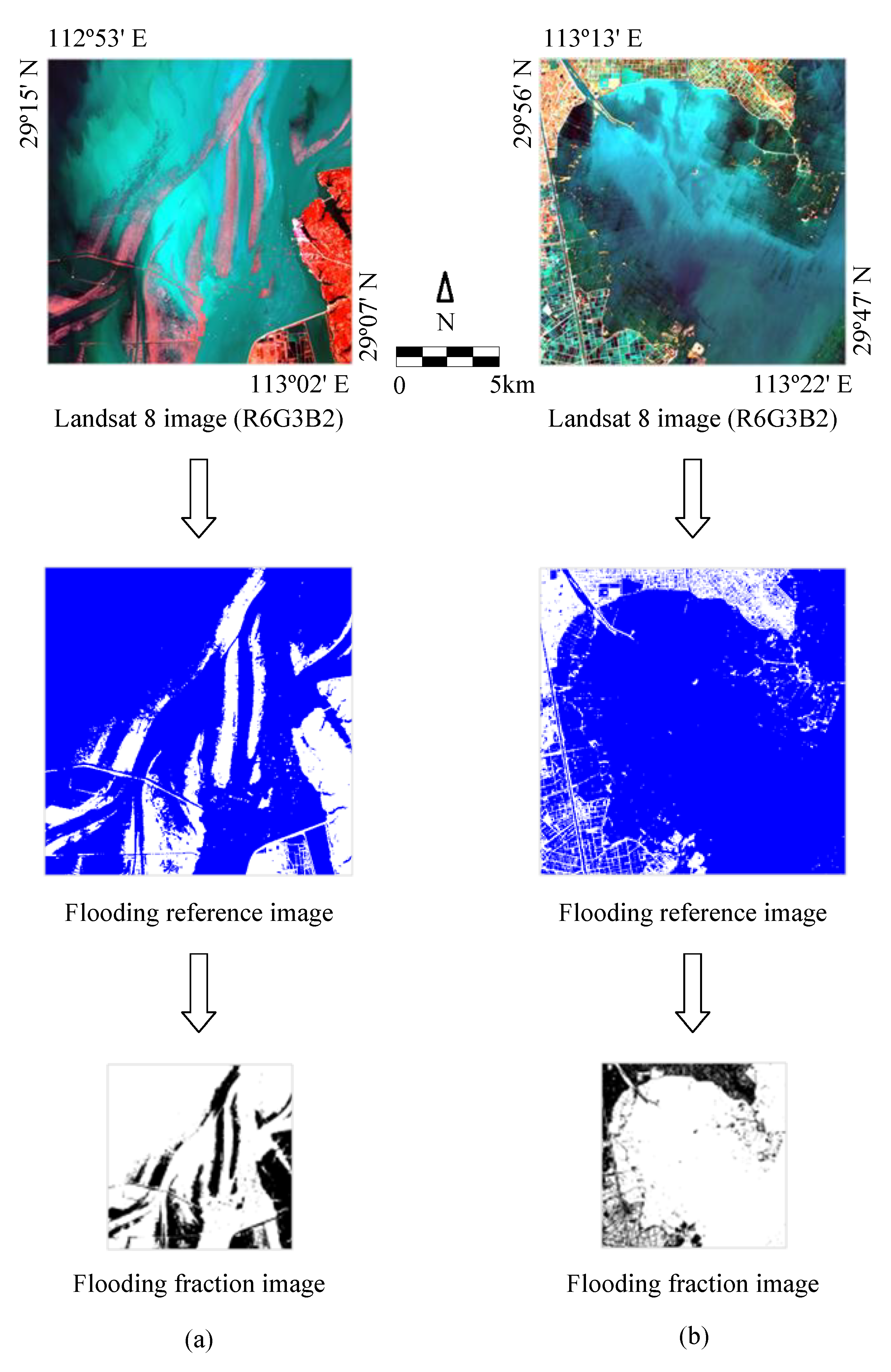
3.1. Study Materials
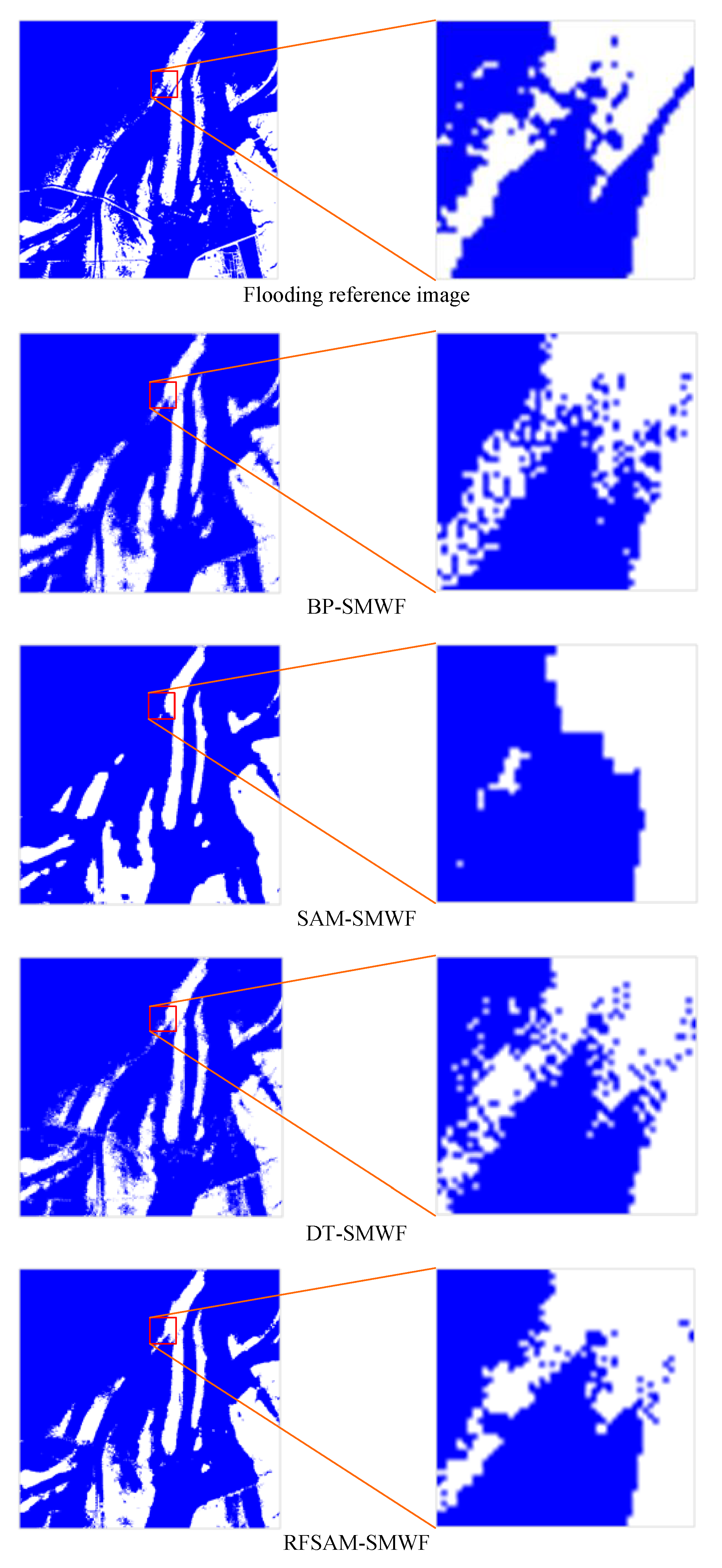
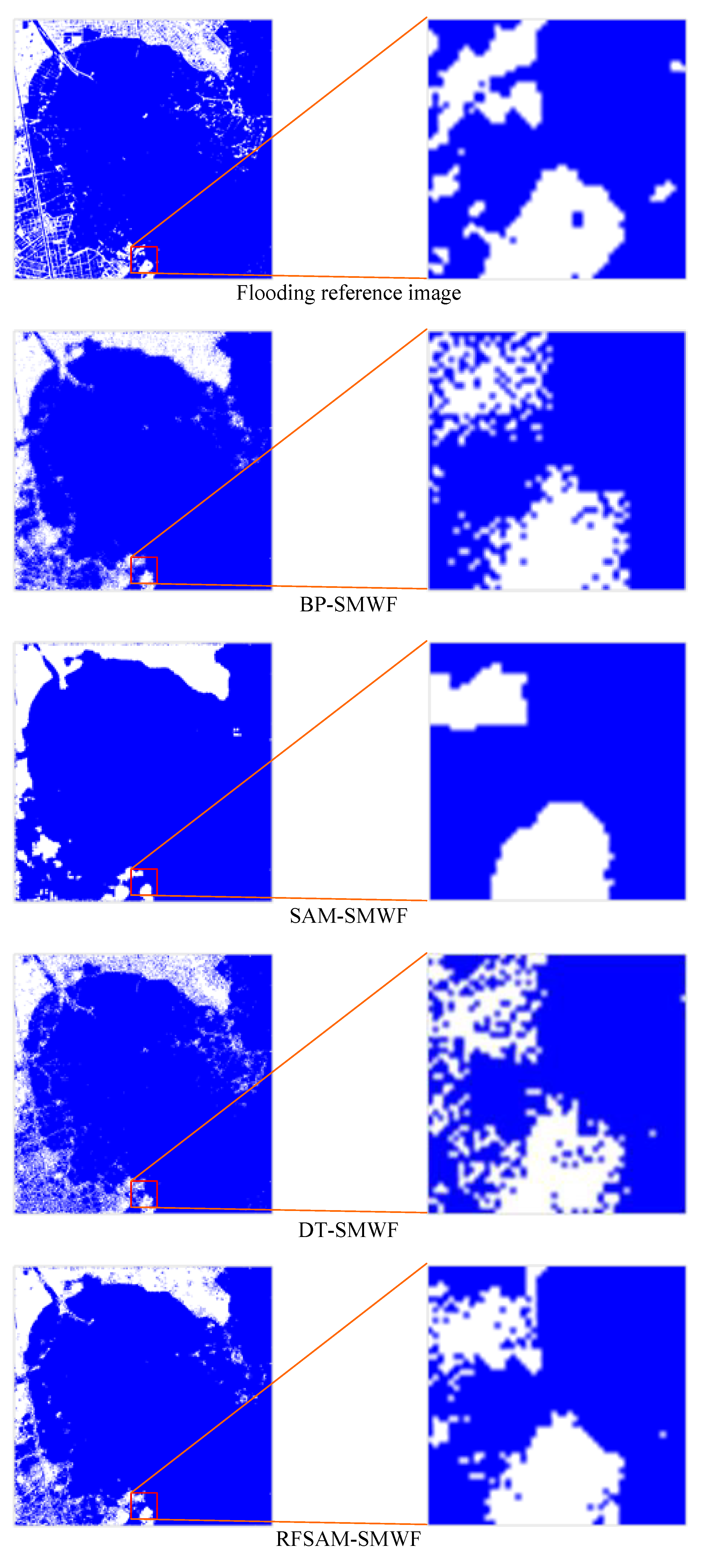
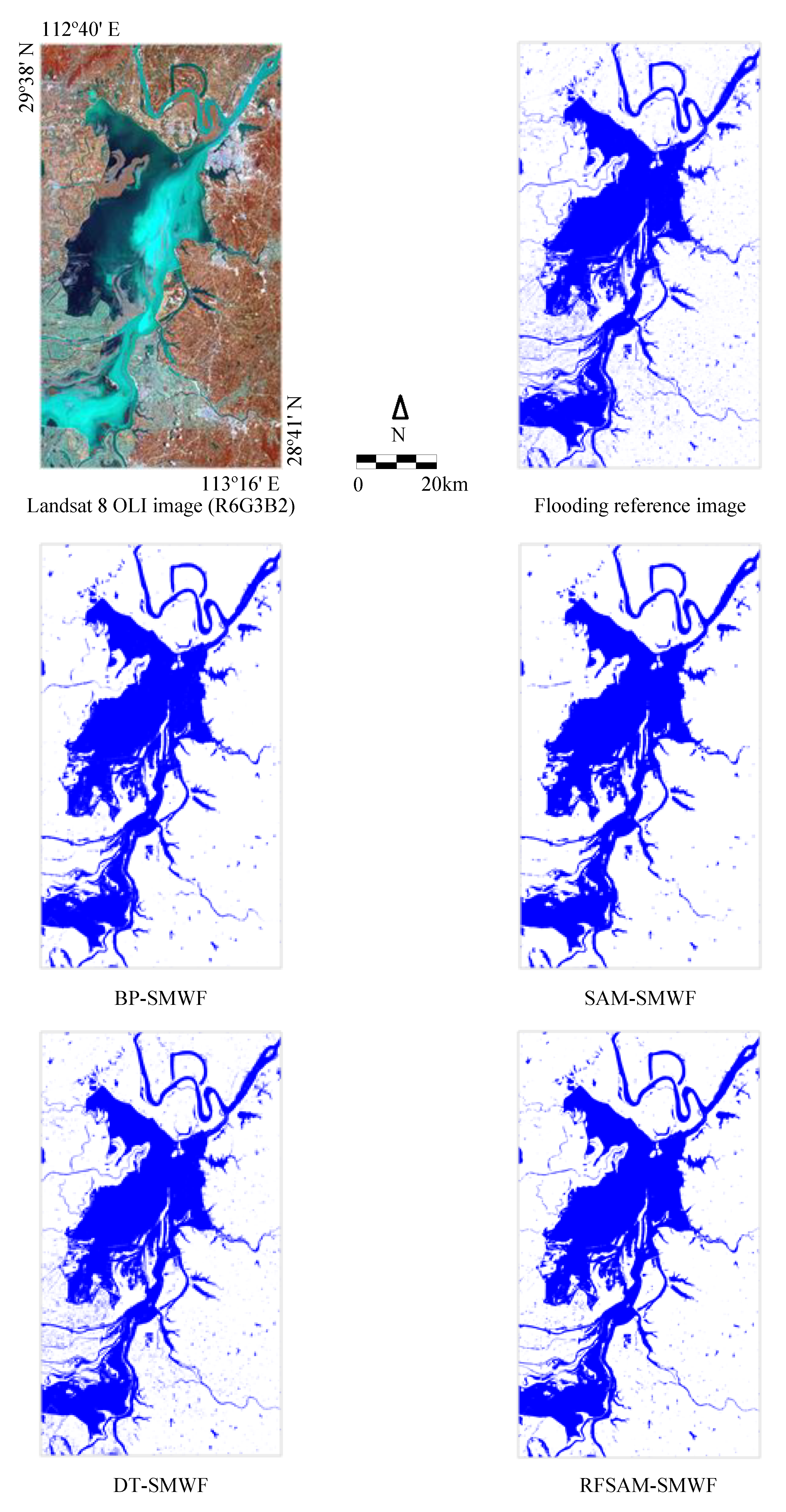
3.2. Results and Analysis
4. Discussion
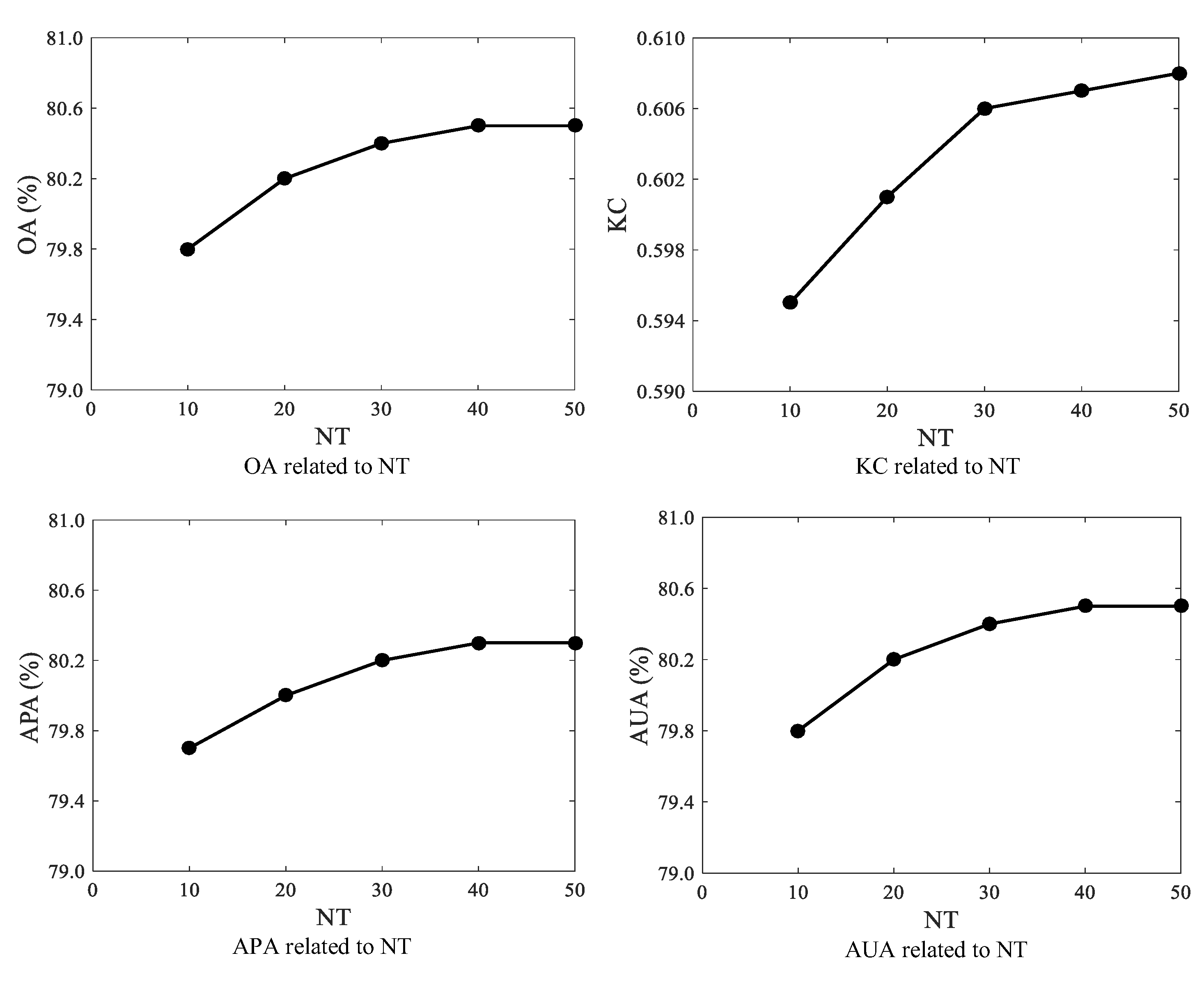
4.1. Choosing the Number of Trees in RFSAM-SMWF
4.2. Setting the Complexity Threshold in RFSAM-SMWF
4.3. Evaluating SMWF Algorithms with Data from a Large Area
5. Conclusions
Author Contributions
Funding
Acknowledgments
Conflicts of Interest
References
- Sarkar, U.K.; Borah, B.C. Flood plain wetland fisheries of India: With special reference to impact of climate change. Wetl. Ecol. Manag. 2018, 26, 1–15. [Google Scholar]
- Ramsar. The Importance of Wetlands. Available online: https://www.ramsar.org (accessed on 5 December 2018).
- Chen, Y.; Liu, R.; Barrett, D.; Gao, L.; Zhou, M.; Renzullo, L.; Emelyanova, I. A spatial assessment framework for evaluating flood risk under extreme climates. Sci. Total Environ. 2015, 538, 512–523. [Google Scholar] [CrossRef]
- Huang, C.; Chen, Y.; Zhang, S.; Wu, J. Detecting, extracting, and monitoring surface water from space using optical sensors: A review. Rev. Geophys. 2018, 56, 333–360. [Google Scholar] [CrossRef]
- Li, L.; Chen, Y.; Xu, T.; Liu, R.; Shi, K.; Huang, C. Super-resolution mapping of wetland inundation from remote sensing imagery based on integration of back-propagation neural network and genetic algorithm. Remote Sens. Environ. 2015, 164, 142–154. [Google Scholar] [CrossRef]
- Huang, C.; Chen, Y.; Zhang, S.; Li, L.; Shi, K.; Liu, R. Spatial downscaling of Suomi NPP-VIIRS image for lake mapping. Water 2017, 9, 834. [Google Scholar] [CrossRef]
- Wu, S.; Ren, J.; Chen, Z.; Jin, W.; Liu, X.; Li, H.; Pan, H.; Guo, W. Influence of reconstruction scale, spatial resolution and pixel spatial relationships on the sub-pixel mapping accuracy of a double-calculated spatial attraction model. Remote Sens. Environ. 2018, 210, 345–361. [Google Scholar] [CrossRef]
- Lu, L.; Huang, Y.; Di, L.; Hang, D. A new spatial attraction model for improving subpixel land cover classification. Remote Sens. 2017, 9, 360. [Google Scholar] [CrossRef]
- Wu, K.; Du, Q.; Hu, X.; Wang, X. Sub-Pixel mapping based on MAP model and spatial attraction theory for remotely sensed image. IEEE Access. 2017, 5, 25126–25132. [Google Scholar] [CrossRef]
- Li, L.; Xu, T.; Chen, Y. Improved urban flooding mapping from remote sensing images using generalized regression neural network-based super-resolution algorithm. Remote Sens. 2016, 8, 625. [Google Scholar] [CrossRef]
- Arun, P.V.; Buddhiraju, K.M.; Porwal, A. CNN based sub-pixel mapping for hyperspectral images. Neurocomputing 2018, 311, 51–64. [Google Scholar] [CrossRef]
- Tiwari, L.K.; Sinha, S.K.; Saran, S.; Tolpekin, V.A.; Raju, P.L.N. Markov random field-based method for super-resolution mapping of forest encroachment from remotely sensed ASTER image. Geocartogr. Int. 2016, 31, 428–445. [Google Scholar] [CrossRef]
- He, D.; Zhong, Y.; Feng, R.; Zhang, L. Spatial-temporal sub-pixel mapping based on swarm intelligence theory. Remote Sens. 2016, 8, 894. [Google Scholar] [CrossRef]
- Li, L.; Chen, Y.; Yu, X.; Liu, R.; Huang, C. Sub-pixel flood inundation mapping from multispectral remotely sensed images based on discrete particle swarm optimization. ISPRS J. Photogramm. Remote Sens. 2015, 101, 10–21. [Google Scholar] [CrossRef]
- Nami, S.; Shajari, M. Cost-sensitive payment card fraud detection based on dynamic random forest and k-nearest neighbors. Expert Syst. Appl. 2018, 110, 381–392. [Google Scholar] [CrossRef]
- Paul, A.; Mukherjee, D.P.; Das, P.; Gangopadhyay, A.; Chintha, A.R.; Kundu, S. Improved random forest for classification. IEEE Trans. Image Process. 2018, 27, 4012–4024. [Google Scholar] [CrossRef]
- Zhang, H.; Li, Q.; Liu, J.; Shang, J.; Du, X.; McNairn, H.; Champagne, C.; Dong, T.; Liu, M. Image classification using RapidEye data: Integration of spectral and textual features in a random forest classifier. IEEE J. Sel. Top. Appl. Earth Observ. Remote Sens. 2017, 10, 5334–5349. [Google Scholar] [CrossRef]
- Xia, X.; Togneri, R.; Sohel, F.; Huang, D. Random forest classification based acoustic event detection utilizing contextual-information and bottleneck features. Pattern Recogn. 2018, 81, 1–13. [Google Scholar] [CrossRef]
- Breiman, L. Random forests. Mach. Learn. 2001, 45, 5–32. [Google Scholar] [CrossRef]
- Breiman, L.; Cutler, A. Random Forests. Available online: https://www.stat.berkeley.edu/~breiman/RandomForests/cc_home.htm (accessed on 10 December 2018).
- Brokamp, C.; Jandarov, R.; Hossain, M.; Ryan, P. Predicting daily urban fine particulate matter concentrations using a random forest model. Environ. Sci. Technol. 2018, 52, 4173–4179. [Google Scholar] [CrossRef]
- Araki, S.; Shima, M.; Yamamoto, K. Spatiotemporal land use random forest model for estimating metropolitan NO2 exposure in Japan. Sci. Total Environ. 2018, 634, 1269–1277. [Google Scholar] [CrossRef]
- Ouallouche, F.; Lazri, M.; Ameur, S. Improvement of rainfall estimation from MSG data using random forests classification and regression. Atmos. Res. 2018, 211, 62–72. [Google Scholar] [CrossRef]
- Zimmer, V.A.; Glocker, B.; Hahner, N.; Eixarch, E.; Sanroma, G.; Gratacos, E.; Rueckert, D.; Ballester, M.A.G.; Piella, G. Learning and combining image neighborhoods using random forests for neonatal brain disease classification. Med. Image Anal. 2017, 42, 189–199. [Google Scholar] [CrossRef]
- Su, X.; Pena, A.T.; Liu, L.; Levine, R.A. Random forests of interaction trees for estimating individualized treatment effects in randomized trials. Stat. Med. 2018, 37, 2547–2560. [Google Scholar] [CrossRef]
- Assouline, D.; Mohajeri, N.; Scartezzini, J.L. Large-scale rooftop solar photovoltaic technical potential estimation using Random Forests. Appl. Energy 2018, 217, 189–211. [Google Scholar] [CrossRef]
- Renno, C.; Petito, F. Triple junction cell temperature evaluation in a CPV system by means of a Random-Forest model. Energy Convers. Manag. 2018, 169, 124–136. [Google Scholar] [CrossRef]
- Wang, Z.; Wang, Y.; Zeng, R.; Srinivasan, R.S.; Ahrentzen, S. Random Forest based hourly building energy prediction. Energy Build. 2018, 171, 11–25. [Google Scholar] [CrossRef]
- Wang, B.; Gao, L.; Juan, Z. Travel mode detection using GPS data and socioeconomic attributes based on a random forest classifier. IEEE Trans. Intell. Transp. Syst. 2018, 19, 1547–1558. [Google Scholar] [CrossRef]
- Kuang, X.; Fu, W.; Yang, L. Real-time detection and recognition of road traffic signs using MSER and random forests. Int. J. Online Eng. 2018, 14, 34–51. [Google Scholar] [CrossRef]
- Behrens, C.; Pierdzioch, C.; Risse, M. Testing the optimality of inflation forecasts under flexible loss with random forests. Econ. Model. 2018, 72, 270–277. [Google Scholar] [CrossRef]
- Houborg, R.; McCabe, M.F. A hybrid training approach for leaf area index estimation via Cubist and random forests machine-learning. ISPRS J. Photogramm. Remote Sens. 2018, 135, 173–188. [Google Scholar] [CrossRef]
- Pullanagari, R.R.; Kereszturi, G.; Yule, I. Integrating airborne hyperspectral, topographic, and soil data for estimating pasture quality using recursive feature elimination with random forest regression. Remote Sens. 2018, 10, 1117. [Google Scholar] [CrossRef]
- Liu, W.; Yang, J.; Li, P.; Han, Y.; Zhao, J.; Shi, H. A novel object-based supervised classification method with active learning and random forest for PolSAR imagery. Remote Sens. 2018, 10, 1092. [Google Scholar] [CrossRef]
- Mertens, K.C.; De Baets, B.; Verbeke, L.P.C.; De Wulf, R.R. A sub-pixel mapping algorithm based on sub-pixel/pixel spatial attraction models. Int. J. Remote Sens. 2006, 27, 3293–3310. [Google Scholar] [CrossRef]
- Ramsar. Wetlands of International Importance (Ramsar Sites). Available online: https://www.ramsar.org (accessed on 12 December 2018).
- Chetan, M.A.; Dornik, A.; Urdea, P. Analysis of recent changes in natural habitat types in the Apuseni Mountains (Romania), using multi-temporal Landsat satellite imagery (1986–2015). Appl. Geogr. 2018, 97, 161–175. [Google Scholar] [CrossRef]
- Markogianni, V.; Kalivas, D.; Petropoulos, G.P.; Dimitriou, E. An appraisal of the potential of Landsat 8 in estimating Chlorophyll-a, Ammonium Concentrations and other water quality indicators. Remote Sens. 2018, 10, 1018. [Google Scholar] [CrossRef]
- Ge, Y.; Chen, Y.; Li, S.; Jiang, Y. Vectorial boundary-based sub-pixel mapping method for remote-sensing imagery. Int. J. Remote Sens. 2014, 35, 1756–1768. [Google Scholar] [CrossRef]
- The MathWorks, Inc. Available online: https://ww2.mathworks.cn/help/ (accessed on 15 December 2018).
- Cabral, A.I.R.; Silva, S.; Silva, P.C.; Vanneschi, L.; Vasconcelos, M.J. Burned area estimations derived from Landsat ETM plus and OLI data: Comparing genetic programming with maximum likelihood and classification and regression trees. ISPRS J. Photogramm. Remote Sens. 2018, 142, 94–105. [Google Scholar] [CrossRef]
- Chen, J.; Du, P.; Wu, C.; Xia, J.; Chanussot, J. Mapping urban land cover of a large area using multiple sensors multiple features. Remote Sens. 2018, 10, 872. [Google Scholar] [CrossRef]


| Study Area 1 | Study Area 2 | |
|---|---|---|
| Location | East Dongting Lake Wetland, Hunan Province, China | Honghu Wetland, Hubei Province, China |
| Ramsar site number | 551 | 1729 |
| Ramsar designation date | 31 March 1992 | 2 February 2008 |
| Experimental data | Landsat 8 OLI imagery | Landsat 8 OLI imagery |
| Image date | 26 July 2017 | 23 July 2016 |
| Image size | 500 × 500 pixels | 500 × 500 pixels |
| Image resolution | 30 m | 30 m |
| Area | 225 km2 | 225 km2 |
| Methods | East Dongting Lake Wetland | Honghu Wetland | ||||||
|---|---|---|---|---|---|---|---|---|
| OA (%) | KC | APA (%) | AUA (%) | OA (%) | KC | APA (%) | AUA (%) | |
| BP-SMWF | 72.8 | 0.454 | 72.7 | 72.7 | 70.1 | 0.393 | 69.6 | 69.7 |
| SAM-SMWF | 75.8 | 0.513 | 75.5 | 76.1 | 73.3 | 0.447 | 71.9 | 73.7 |
| DT-SMWF | 75.5 | 0.508 | 75.4 | 75.4 | 70.2 | 0.397 | 69.9 | 69.8 |
| RFSAM-SMWF | 80.2 | 0.601 | 80.0 | 80.2 | 76.7 | 0.527 | 76.3 | 76.4 |
| CT | NCMP | NMP | PCMP (%) | OA (%) | KC | APA (%) | AUA (%) |
|---|---|---|---|---|---|---|---|
| 0.05 | 1423 | 2058 | 69.1 | 80.7 | 0.613 | 80.6 | 80.7 |
| 0.10 | 991 | 2058 | 48.2 | 80.2 | 0.601 | 80.0 | 80.2 |
| 0.20 | 563 | 2058 | 27.4 | 78.9 | 0.575 | 78.6 | 79.0 |
| 0.50 | 177 | 2058 | 8.6 | 76.9 | 0.534 | 76.5 | 77.1 |
| Methods | East Dongting Lake Wetland | |||
|---|---|---|---|---|
| OA (%) | Kappa | APA (%) | AUA (%) | |
| BP-SMWF | 74.1 | 0.397 | 68.8 | 71.6 |
| SAM-SMWF | 78.3 | 0.492 | 73.1 | 77.3 |
| DT-SMWF | 79.4 | 0.542 | 76.8 | 77.4 |
| RFSAM-SMWF | 82.9 | 0.606 | 79.1 | 82.1 |
© 2019 by the authors. Licensee MDPI, Basel, Switzerland. This article is an open access article distributed under the terms and conditions of the Creative Commons Attribution (CC BY) license (http://creativecommons.org/licenses/by/4.0/).
Share and Cite
Li, L.; Chen, Y.; Xu, T.; Shi, K.; Liu, R.; Huang, C.; Lu, B.; Meng, L. Remote Sensing of Wetland Flooding at a Sub-Pixel Scale Based on Random Forests and Spatial Attraction Models. Remote Sens. 2019, 11, 1231. https://doi.org/10.3390/rs11101231
Li L, Chen Y, Xu T, Shi K, Liu R, Huang C, Lu B, Meng L. Remote Sensing of Wetland Flooding at a Sub-Pixel Scale Based on Random Forests and Spatial Attraction Models. Remote Sensing. 2019; 11(10):1231. https://doi.org/10.3390/rs11101231
Chicago/Turabian StyleLi, Linyi, Yun Chen, Tingbao Xu, Kaifang Shi, Rui Liu, Chang Huang, Binbin Lu, and Lingkui Meng. 2019. "Remote Sensing of Wetland Flooding at a Sub-Pixel Scale Based on Random Forests and Spatial Attraction Models" Remote Sensing 11, no. 10: 1231. https://doi.org/10.3390/rs11101231
APA StyleLi, L., Chen, Y., Xu, T., Shi, K., Liu, R., Huang, C., Lu, B., & Meng, L. (2019). Remote Sensing of Wetland Flooding at a Sub-Pixel Scale Based on Random Forests and Spatial Attraction Models. Remote Sensing, 11(10), 1231. https://doi.org/10.3390/rs11101231