Satellite Data to Improve the Knowledge of Geohazards in World Heritage Sites

 ,
,  , ,
, ,  and
and 
Abstract
1. Introduction
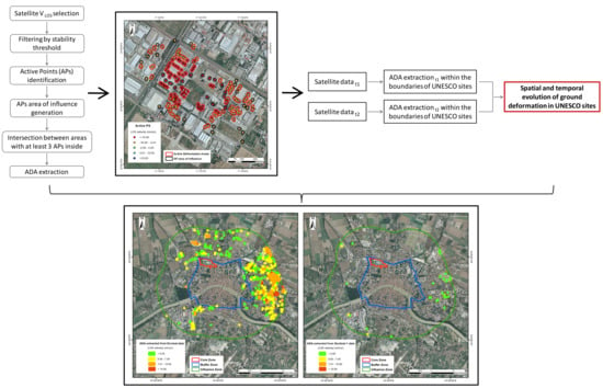
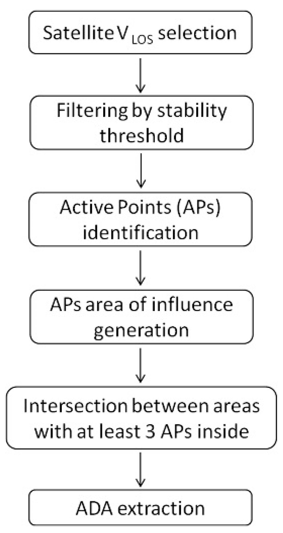
2. Procedure for the Identification and Updating of Slow-Kinematic Ground Deformation in UNESCO Sites
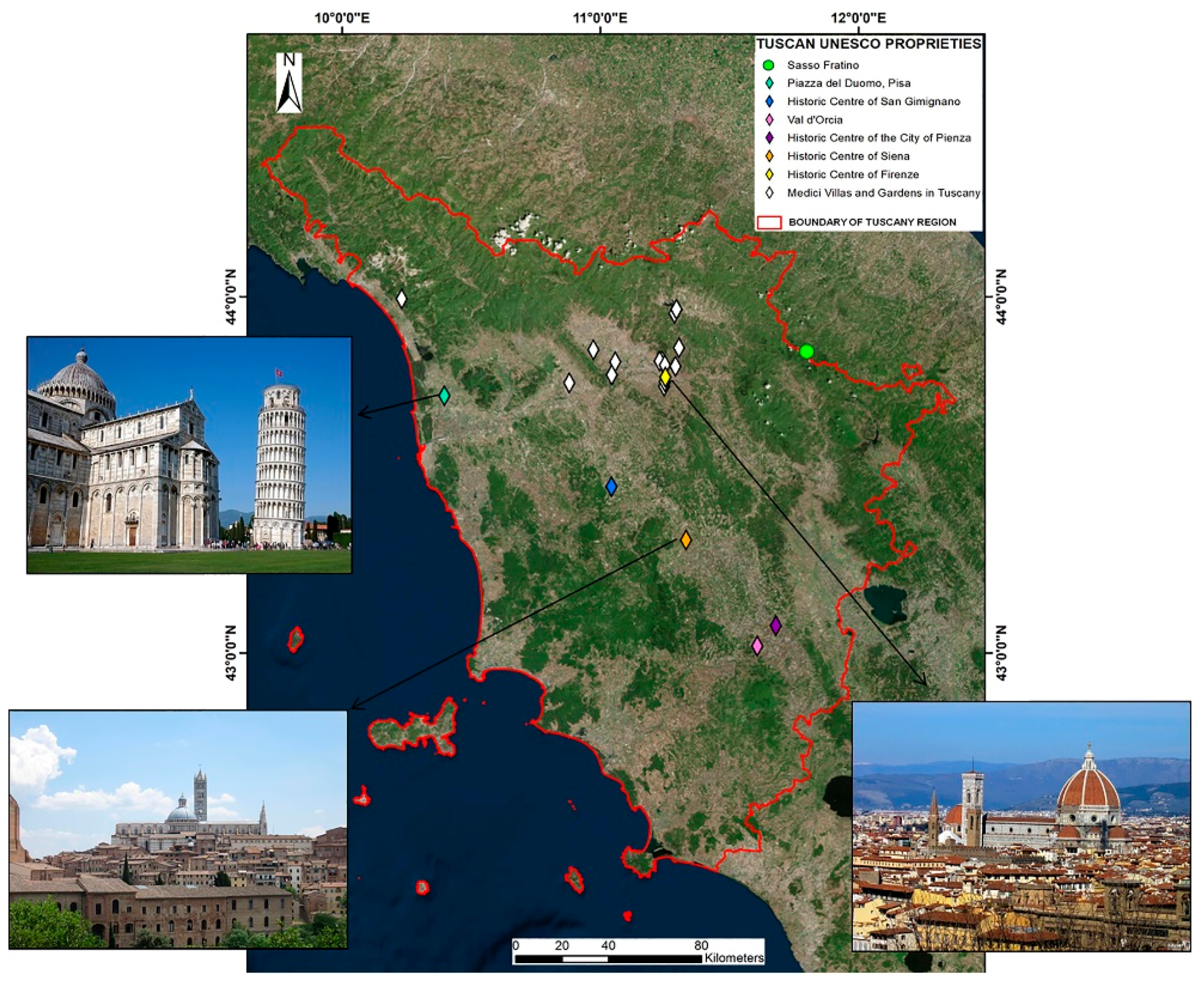
3. An Overview of the UNESCO Sites in Tuscany
4. Data Collection
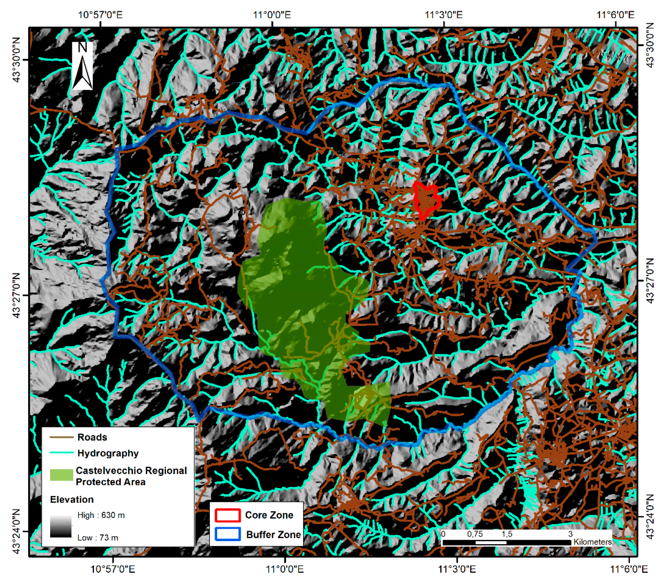
4.1. UNESCO Boundaries
4.2. The Influence Zones: New Boundaries
4.3. Satellite Datasets
5. Results
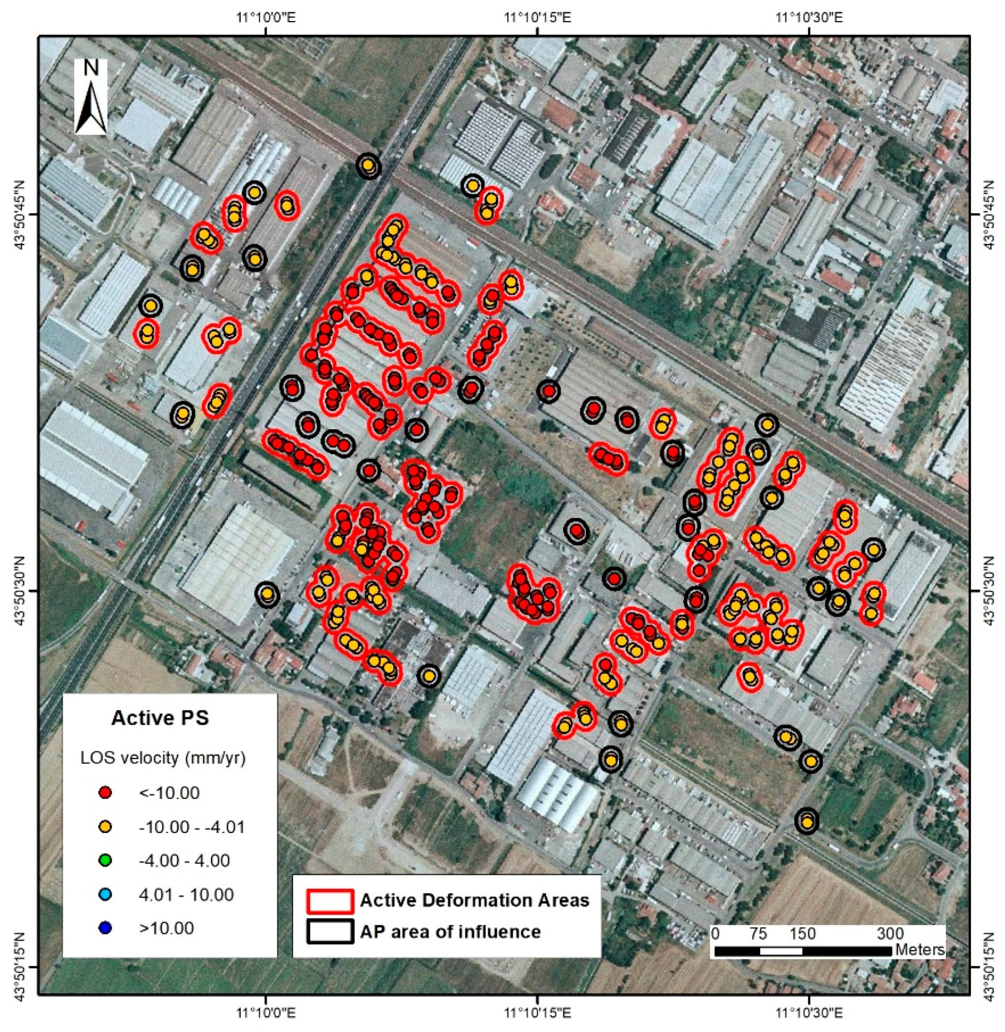
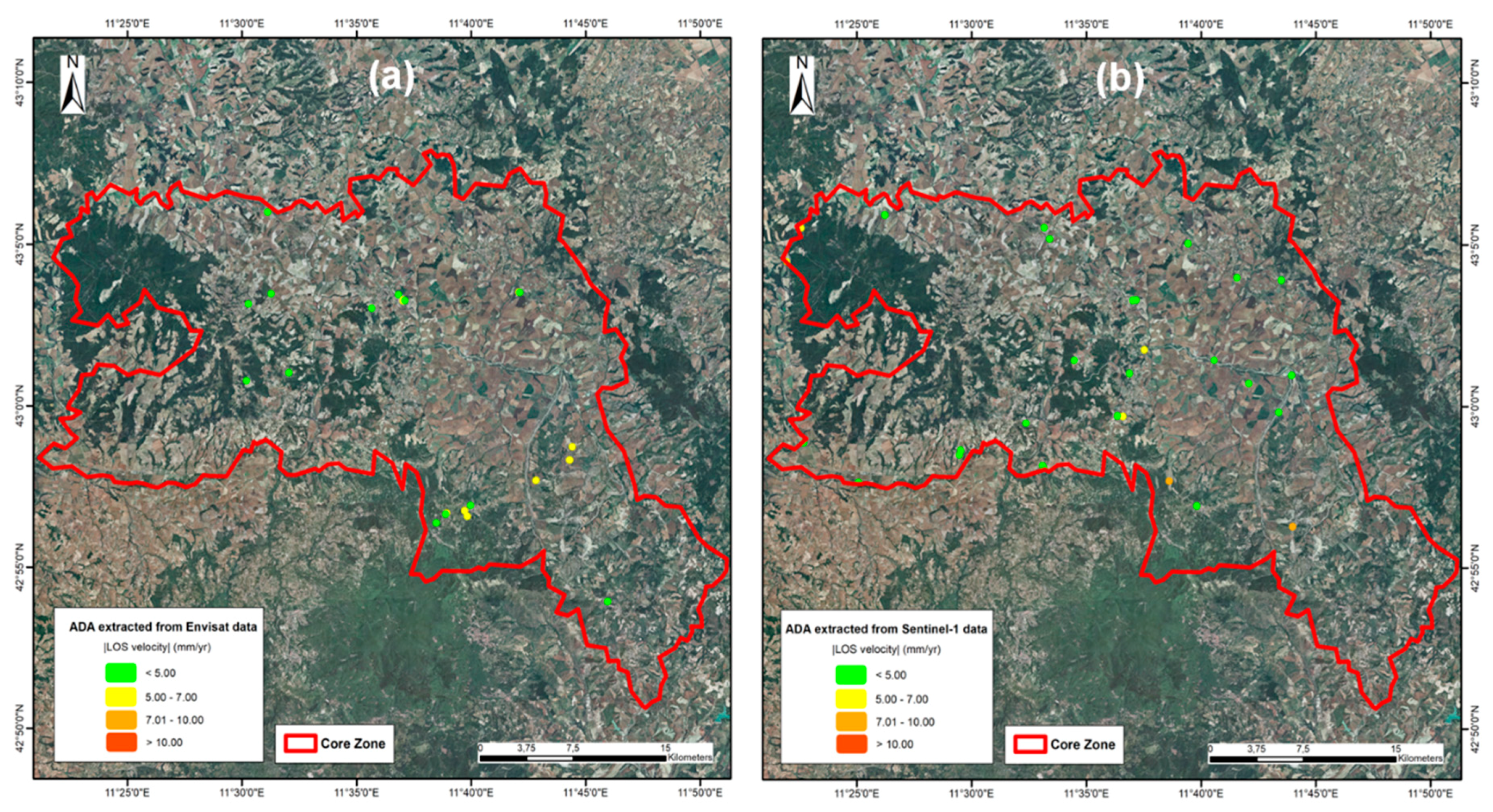
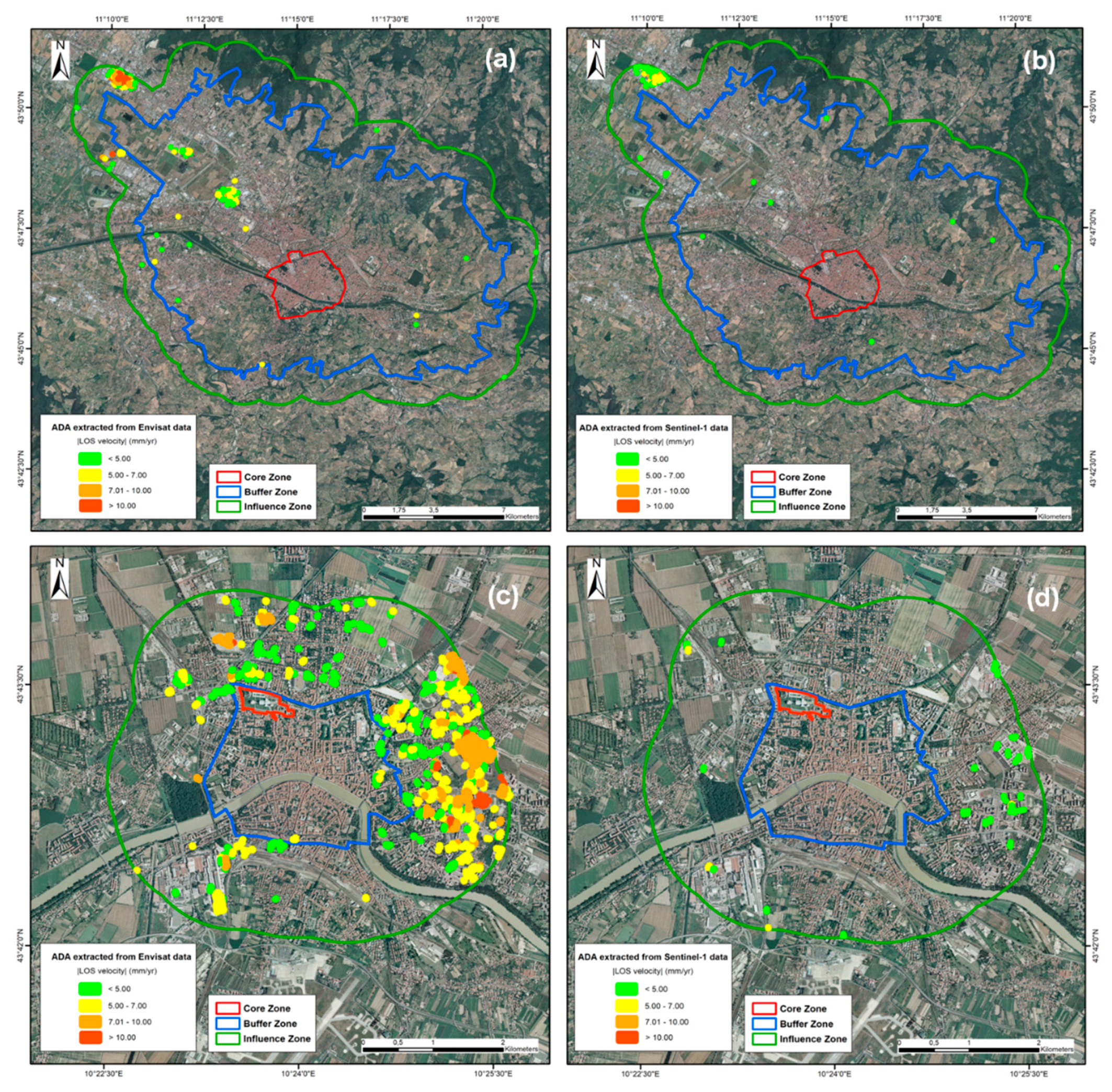
5.1. The First Step of Active Deformation Areas (ADA) Extraction
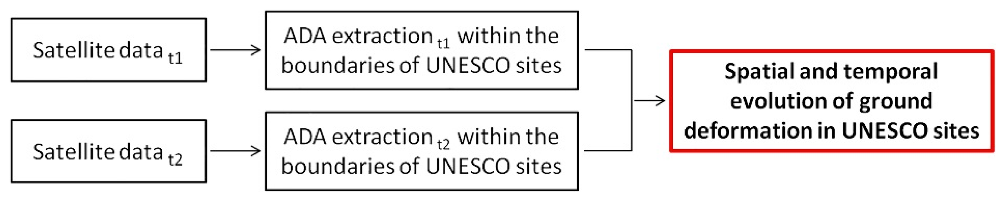
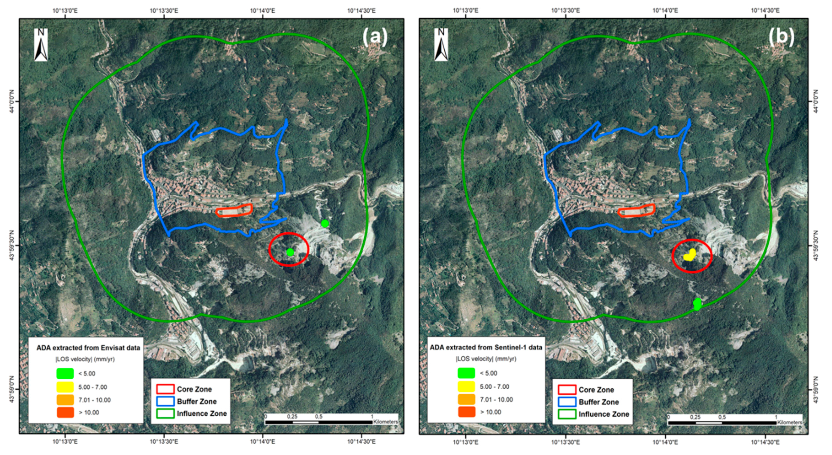
5.2. Active Deformation Areas (ADA) Extracted within the Boundaries of UNESCO Tuscan Sites
6. Discussion
7. Conclusions
Supplementary Materials
Author Contributions
Funding
Acknowledgments
Conflicts of Interest
References
- Galland, P.; Lisitzin, K.; Oudaille-Diethardt, A.; Young, C. World Heritage in Europe Today; United Nations Educational, Scientific and Cultural Organization: Paris, France, 2016; Volume 123, ISBN 978-92-3-100143-7. [Google Scholar]
- UNESCO. Operational Guidelines for the Implementation of the World Heritage Convention; UNESCO, World Heritage Center: Paris, France, 2017; Available online: http://whc.unesco.org/en/guidelines/ (accessed on 10 January 2018).
- Pavlova, I.; Makarigakis, A.; Depret, T.; Jomelli, V. Global overview of the geological hazard exposure and disaster risk awareness at world heritage sites. J. Cult. Heritage 2017, 28, 151–157. [Google Scholar] [CrossRef]
- Spizzichino, D.; Leoni, G.; Comerci, V.; Brustia, E.; Guerrieri, L.; Dessi, B.; Trigila, A.; Iadanza, C. PROTHEGO Deliverable D.01.01: UNESCO Cultural Heritage Vs Natural hazards at European Scale, Version 1.0. JPICH Heritage Plus PROTHEGO Project, Open Report. 2016, p. 30. Available online: http://www.prothego.eu/ (accessed on 21 February 2018).
- Cigna, F.; Tapete, D.; Lee, K. Geological hazards in the UNESCO World Heritage sites of the UK: From the global to the local scale perspective. Earth-Sci. Rev. 2018, 176, 166–194. [Google Scholar] [CrossRef]
- Canuti, P.; Margottini, C.; Fanti, R.; Bromhead, E.N. Cultural Heritage and Landslides: Research for Risk Prevention and Conservation. In Landslides—Disaster Risk Reduction; Sassa, K., Canuti, P., Eds.; Springer: Berlin/Heidelberg, Germany, 2009; pp. 401–433. [Google Scholar] [CrossRef]
- Periodic Reporting. Available online: http://whc.unesco.org/en/periodicreporting/ (accessed on 10 December 2018).
- List of Factors Affecting the Properties. Available online: http://whc.unesco.org/en/factors/ (accessed on 10 December 2018).
- Cruden, D.M.; Varnes, D.J. Landslide Types and Processes. In Landslides: Investigation and Mitigation, Special Report 247-Transportation Research Board, National Research Council; Turner, A.K., Schuster, R.L., Eds.; National Academy Press: Washington, DC, USA, 1996; pp. 36–75. [Google Scholar]
- Cigna, F.; Osmanoğlu, B.; Cabral-Cano, E.; Dixon, T.H.; Ávila-Olivera, J.A.; Garduño-Monroy, V.H.; DeMets, C.; Wdowinski, S. Monitoring land subsidence and its induced geological hazard with Synthetic Aperture Radar Interferometry: A case study in Morelia, Mexico. Remote Sens. Environ. 2012, 117, 146–161. [Google Scholar] [CrossRef]
- Vlcko, J. Extremely slow slope movements influencing the stability of Spis Castle, UNESCO site. Landslides 2004, 1, 67–71. [Google Scholar] [CrossRef]
- Alfarè, L.; Donnici, S.; Marini, M.; Moscatelli, M.; Tosi, L.; Vallone, R. The Impact of Land Subsidence on Preservation of Cultural Heritage Sites: The Case Study of Aquileia (Venetian-Friulian Coastland, North-Eastern Italy). In Engineering Geology for Society and Territory; Springer: Cham, Switzerland, 2014; Volume 4, pp. 179–182. [Google Scholar]
- Tapete, D.; Cigna, F. InSAR data for geohazard assessment in UNESCO World Heritage sites: State-of-the-art and perspectives in the Copernicus era. Int. J. App. Earth Obs. Geoinf. 2017, 63, 24–32. [Google Scholar] [CrossRef]
- Ferretti, A.; Prati, C.; Rocca, F. Permanent Scatterers in SAR interferometry. IEEE Trans. Geosci. Remote Sens. 2001, 39, 8–20. [Google Scholar] [CrossRef]
- Crosetto, M.; Monserrat, O.; Cuevas-González, M.; Devanthéry, N.; Crippa, B. Persistent scatterer interferometry: A review. ISPRS J. Photogramm. Remote Sens. 2016, 115, 78–89. [Google Scholar] [CrossRef]
- Ciampalini, A.; Raspini, F.; Frodella, W.; Bardi, F.; Bianchini, S.; Moretti, S. The effectiveness of high-resolution LiDAR data combined with PSInSAR data in landslide study. Landslides 2016, 13, 399–410. [Google Scholar] [CrossRef]
- Lu, P.; Casagli, N.; Catani, F.; Tofani, V. Persistent Scatterers Interferometry Hotspot and Cluster Analysis (PSI-HCA) for detection of extremely slow-moving landslides. Int. J. Remote Sens. 2012, 33, 466–489. [Google Scholar] [CrossRef]
- Tofani, V.; Raspini, F.; Catani, F.; Casagli, N. Persistent Scatterer Interferometry (PSI) technique for landslide characterization and monitoring. Remote Sens. 2013, 5, 1045–1065. [Google Scholar] [CrossRef]
- Bonforte, A.; Guglielmino, F.; Coltelli, M.; Ferretti, A.; Puglisi, G. Structural assessment of Mount Etna volcano from permanent scatterers analysis. Geochem. Geophys. Geosyst. 2011, 12, 1–19. [Google Scholar] [CrossRef]
- Nolesini, T.; Frodella, W.; Bianchini, S.; Casagli, N. Detecting slope and urban potential unstable areas by means of multi-platform remote sensing techniques: The volterra (Italy) case study. Remote Sens. 2016, 8, 746. [Google Scholar] [CrossRef]
- Rosi, A.; Tofani, V.; Agostini, A.; Tanteri, L.; Tacconi Stefanelli, C.; Catani, F.; Casagli, N. Subsidence mapping at regional scale using persistent scatters interferometry (PSI): The case of Tuscany region (Italy). Int. J. App. Earth Obs. Geoinf. 2016, 52, 328–337. [Google Scholar] [CrossRef]
- Raspini, F.; Bardi, F.; Bianchini, S.; Ciampalini, A.; Del Ventisette, C.; Farina, P.; Ferrigno, F.; Solari, L.; Casagli, N. The contribution of satellite SAR-derived displacement measurements in landslide risk management practices. Nat. Hazards 2016, 86, 327–351. [Google Scholar] [CrossRef]
- Rosi, A.; Tofani, V.; Tanteri, L.; TacconiStefanelli, C.; Agostini, A.; Catani, F.; Casagli, N. The new landslide inventory of Tuscany (Italy) updated with PS-InSAR: Geomorphological features and landslide distribution. Landslides 2018, 15, 5–19. [Google Scholar] [CrossRef]
- Solari, L.; Barra, A.; Herrera, G.; Bianchini, S.; Monserrat, O.; Béjar-Pizarro, M.; Crosetto, M.; Sarro, R.; Moretti, S. Fast detection of ground motions on vulnerable elements using Sentinel-1 InSAR data. Geomat. Nat. Hazards Risk 2018, 9, 152–174. [Google Scholar] [CrossRef]
- Ferretti, A.; Fumagalli, A.; Novali, F.; Prati, C.; Rocca, F.; Rucci, A. A new algorithm for processing interferometric data-stacks: SqueeSAR. IEEE Trans. Geosci. Remote Sens. 2011, 49, 3460–3470. [Google Scholar] [CrossRef]
- Bianchini, S.; Pratesi, F.; Nolesini, T.; Casagli, N. Building deformation assessment by means of Persistent Scatterer Interferometry analysis on a Landslide-affected area: The Volterra (Italy) case study. Remote Sens. 2015, 7, 4678–4701. [Google Scholar] [CrossRef]
- Tang, P.; Chen, F.; Zhu, X.; Zhou, W. Monitoring cultural heritage sites with advanced multi-temporal InSAR technique: The case study of the Summer Palace. Remote Sens. 2016, 8, 432. [Google Scholar] [CrossRef]
- Tapete, D.; Fanti, R.; Cecchi, R.; Petrangeli, P.; Casagli, N. Satellite radar interferometry for monitoring and early-stage warning of structural instability in archaeological sites. J. Geophys. Eng. 2012, 9, 10–25. [Google Scholar] [CrossRef]
- Tapete, D.; Cigna, F. Rapid mapping and deformation analysis over cultural heritage and rural sites based on Persistent Scatterer Interferometry. Int. J. Geophys. 2012, 2012, 618609. [Google Scholar] [CrossRef]
- Barra, A.; Monserrat, O.; Mazzanti, P.; Esposito, C.; Crosetto, M.; Scarascia Mugnozza, G. First insights on the potential of Sentinel-1 for landslides detection. Geomat. Nat. Hazards Risk 2016, 7, 1874–1883. [Google Scholar] [CrossRef]
- Crosetto, M.; Monserrat, O.; Devanthéry, N.; Cuevas-González, M.; Barra, A.; Crippa, B. Persistent Scatterer Interferometry using Sentinel-1 data. In Proceedings of the International Archives of the Photogrammetry, Remote Sensing and Spatial Information Sciences, 2016 XXIII ISPRS Congress, Prague, Czech Republic, 12–19 July 2016; Volume XLI-B7. [Google Scholar]
- Devanthéry, N.; Crosetto, M.; Cuevas-González, M.; Monserrat, O.; Barra, A.; Crippa, B. Deformation monitoring using Persistent Scatterer Interferometry and Sentinel-1 SAR data. Procedia Comput. Sci. 2016, 100, 1121–1126. [Google Scholar] [CrossRef]
- Barra, A.; Solari, L.; Bejar-Pizarro, M.; Monserrat, O.; Bianchini, S.; Herrera, G.; Crosetto, M.; Sarro, R.; Gonzalez-Alonso, E.; Mateos, R.M.; et al. A methodology to detect and update Active Deformation Areas based on Sentinel-1 SAR images. Remote Sens. 2017, 9, 1002. [Google Scholar] [CrossRef]
- World Heritage List Statistics. Available online: http://whc.unesco.org/en/list/stat (accessed on 18 January 2018).
- The Criteria for Selection. Available online: https://whc.unesco.org/en/criteria/ (accessed on 2 February 2018).
- Martin, O.; Piatti, G. World Heritage and Buffer Zones. In Proceedings of the International Expert Meeting on World Heritage and Buffer Zones, Davos, Switzerland, 11–14 March 2008; UNESCO World Heritage Center: Paris, France, 2009. Available online: http://whc.unesco.org/en/series/25/ (accessed on 29 January 2018).
- World Heritage List. Available online: http://whc.unesco.org/en/list (accessed on 20 January 2018).
- Capitanio, C.; Bini, M.; Francini, C. The Safeguarding Area for the Historic Center of Florence, UNESCO Site; DIDA Dipartimento di ArchitetturaUniversitàdegliStudi di Firenze: Firenze, Italy, 2017; ISBN 978889608032. [Google Scholar]
- Regional Cartography of Tuscany. Available online: http://www502.regione.toscana.it/geoscopio/cartoteca.html (accessed on 22 February 2018).
- Costantini, M.; Ferretti, A.; Minati, F.; Falco, S.; Trillo, F.; Colombo, D.; Novali, F.; Malvarosa, F.; Mammone, C.; Vecchioli, F.; et al. Analysis of surface deformations over the whole Italian territory by interferometric processing of ERS, Envisat and COSMO-SkyMed radar data. Remote Sens. Environ. 2017, 202, 250–275. [Google Scholar] [CrossRef]
- Peduto, D.; Cascini, L.; Arena, L.; Ferlisi, S.; Fornaro, G.; Reale, D. A general framework and related procedures for multiscale analyses of DInSAR data in subsiding urban areas. ISPRS J. Photogramm. Remote Sens. 2015, 105, 186–210. [Google Scholar] [CrossRef]
- Pratesi, F.; Tapete, D.; Terenzi, G.; Del Ventisette, C.; Moretti, S. Rating health and stability of engineering structures via classification indexes of InSAR Persistent Scatterers. Int. J. App. Earth Obs. Geoinf. 2015, 40, 81–90. [Google Scholar] [CrossRef]
- Raspini, F.; Bianchini, S.; Ciampalini, A.; Del Soldato, M.; Solari, L.; Novali, F.; Del Conte, S.; Rucci, A.; Ferretti, A.; Casagli, N. Continuous, semi-automatic monitoring of ground deformation using Sentinel-1 satellites. Sci. Rep. 2018, 8, 7253. [Google Scholar] [CrossRef] [PubMed]
- Farina, P.; Casagli, N.; Ferretti, A. Radar-interpretation of InSAR measurements for landslide investigations in civil protection practices. In Proceedings of the First North American Landslide Conference, Vail, CO, USA, 3–8 June 2007; pp. 272–283. [Google Scholar]
- Showstack, R. Sentinel satellites initiate new era in earth observation. Eos Trans. Am. Geophys. Union 2014, 95, 239–240. [Google Scholar] [CrossRef]
- Tomás, R.; Romero, R.; Mulas, J.; Marturià, J.J.; Mallorquí, J.J.; Lopez-Sanchez, J.M.; Herrera, G.; Gutiérrez, F.; González, P.J.; Fernández, J.; et al. Radar interferometry techniques for the study of ground subsidence phenomena: A review of practical issues through cases in Spain. Environ. Earth Sci. 2014, 71, 163–181. [Google Scholar] [CrossRef]
- Pratesi, F.; Tapete, D.; Del Ventisette, C.; Moretti, S. Mapping interactions between geology, subsurface resource exploitation and urban development in transforming cities using InSAR Persistent Scatterers: Two decades of change in Florence, Italy. Appl. Geogr. 2016, 77, 20–37. [Google Scholar] [CrossRef]
- Solari, L.; Ciampalini, A.; Raspini, F.; Bianchini, S.; Zinno, I.; Bonano, M.; Manunta, M.; Moretti, S.; Casagli, N. Combined use of C-and X-Band SAR data for subsidence monitoring in an urban area. Geosciences 2017, 7, 21. [Google Scholar] [CrossRef]
- Della Seta, M.; Del Monte, M.; Fredi, P.; Palmieri, E.L. Space–time variability of denudation rates at the catchment and hillslope scales on the Tyrrhenian side of Central Italy. Geomorphology 2009, 107, 161–177. [Google Scholar] [CrossRef]
- Baroni, C.; Bruschi, G.; Criscuolo, A.; Ribolini, A. Il rischio geomorfologico indotto dall’attivita estrattiva nei bacini marmiferi apuani (AlpiApuane, Toscana). Attidella Societa Toscana di Scienze Naturali Residente in Pisa Memorie Serie Aprocessi Verbali 2001, 107, 87–96. (In Italian) [Google Scholar]


| UNESCO TUSCAN SITES | COORDINATES (Latitude/Longitude) | INSCRIPTION YEAR | INSCRIPTION CRITERIA | TYPE OF PROPERTY | BOUNDARIES (ha) | |||
|---|---|---|---|---|---|---|---|---|
| CULTURAL | NATURAL | MIXED | CORE ZONE | BUFFER ZONE | ||||
| 1. Historic Center of Florence | 43.773/11.256 | 1982 | (i)(ii)(iii)(iv)(vi) | X | 505 | 10,480 | ||
| 2. Historic Center of Siena | 43.319/11.332 | 1995 | (i)(ii)(iv) | X | 170 | 9907 | ||
| 3. Medici Villas and Gardens in Tuscany | ||||||||
| 3.1-Cafaggiolo Villa | 43.965/11.295 | 2013 | (ii)(iv)(vi) | X | 2.35 | 649.56 | ||
| 3.2-Il Trebbio Villa | 43.953/11.287 | 2013 | (ii)(iv)(vi) | X | 16 | 650.31 | ||
| 3.3-Careggi Villa | 43.809/11.249 | 2013 | (ii)(iv)(vi) | X | 3.6 | 55.71 | ||
| 3.4-Medici of Fiesole Villa | 43.806/11.289 | 2013 | (ii)(iv)(vi) | X | 2.11 | 44.88 | ||
| 3.5-Castello Villa | 43.819/11.228 | 2013 | (ii)(iv)(vi) | X | 8.33 | 289.31 | ||
| 3.6-Poggio a Caiano Villa | 43.818/11.056 | 2013 | (ii)(iv)(vi) | X | 9.31 | 135.63 | ||
| 3.7-La Petraia Villa | 43.819/11.237 | 2013 | (ii)(iv)(vi) | X | 21.31 | 276.33 | ||
| 3.8-Boboli Garden | 43.762/11.248 | 2013 | (ii)(iv)(vi) | X | 40 | 132 | ||
| 3.9-Cerreto Guidi Villa | 43.759/10.879 | 2013 | (ii)(iv)(vi) | X | 0.76 | 4.12 | ||
| 3.10-Seravezza Palace | 43.994/10.232 | 2013 | (ii)(iv)(vi) | X | 1.01 | 50.14 | ||
| 3.11-Pratolino Garden | 43.858/11.304 | 2013 | (ii)(iv)(vi) | X | 26.53 | 210.35 | ||
| 3.12-La Magia Villa | 43.852/10.973 | 2013 | (ii)(iv)(vi) | X | 2.1 | 103.65 | ||
| 3.13-Artimino Villa | 43.782/11.044 | 2013 | (ii)(iv)(vi) | X | 1.04 | 701.66 | ||
| 3.14-Poggio Imperiale Villa | 43.749/11.248 | 2013 | (ii)(iv)(vi) | X | 5.35 | 235.43 | ||
| 4. Historic Center of San Gimignano | 43.468/11.042 | 1990 | (i)(iii)(iv) | X | 13.88 | / | ||
| 5. Piazza del Duomo, Pisa | 43.723/10.396 | 1987 | (i)(ii)(iv)(vi) | X | 8.87 | 254 | ||
| 6. Historic Center of the City of Pienza | 43.077/11.679 | 1996 | (i)(ii)(iv) | X | 4.41 | / | ||
| 7. Val d’Orcia | 43.067/11.55 | 2004 | (iv)(vi) | X | 61,187.961 | 5660.077 | ||
| 8. SassoFratino | 43.844/11.803 | 2017 | (ix) | X | 781.43 | 6936.64 | ||
| UNESCO SITE | FACTORS SUMMARY TABLE | ASSESSMENT OF CURRENT NEGATIVE FACTORS | |||||||||
|---|---|---|---|---|---|---|---|---|---|---|---|
| SUDDEN GEOLOGICAL EVENTS | IMPACT | ORIGIN | SPATIAL SCALE | TEMPORAL SCALE | IMPACT | MANAGMENT RESPONSE | TREND | ||||
| NEG | CUR | POT | INS | OUT | |||||||
| 2 | Earthquake | X | X | X | |||||||
| 3 | Earthquake | X | X | X | X | ||||||
| 4 | Earthquake | X | X | X | X | ||||||
| Landslide | X | X | X | X | Restricted | Intermittent or sporadic | Significant | High capacity | Static | ||
| 5 | Earthquake | X | X | X | |||||||
| Dataset | Satellite | Orbit | Time Period | Spatial Resolution (m) | Standard Deviation (mm/Year) |
|---|---|---|---|---|---|
| 1 | Sentinel-1 | Ascending | 2014–2017 | 14 × 4 | 1.6 |
| 2 | Sentinel-1 | Descending | 2014–2017 | 14 × 4 | 1.5 |
| 3 | Envisat | Ascending | 2003–2010 | 20 × 20 | 2.0 |
| 4 | Envisat | Descending | 2003–2010 | 20 × 20 | 2.2 |
| UNESCO Site | ADA Extracted from Envisat Data | ADA Extracted from SENTINEL-1 Data | ||||||||||||||||||||||
|---|---|---|---|---|---|---|---|---|---|---|---|---|---|---|---|---|---|---|---|---|---|---|---|---|
| Core Zone | Buffer Zone | Influence Zone | Core Zone | Buffer Zone | Influence Zone | |||||||||||||||||||
| N° | |Vmax| | |Vmin| | % | N° | |Vmax| | |Vmin| | % | N° | |Vmax| | |Vmin| | % | N° | |Vmax| | |Vmin| | % | N° | |Vmax| | |Vmin| | % | N° | |Vmax| | |Vmin| | % | |
| 1 | 82 | 8.4 | 4.1 | 0.2 | 96 | 16.8 | 4.0 | 0.3 | 7 | 4.3 | 3.2 | NEGL | 56 | 8.3 | 3.1 | 0.1 | ||||||||
| 2 | 11 | 6.3 | 4.5 | NEGL | 15 | 6.6 | 4.2 | NEGL | 2 | 4.7 | 3.8 | NEGL | 1 | 3.7 | 3.7 | NEGL | ||||||||
| 3.9 | 1 | 5.1 | 5.1 | 0.1 | ||||||||||||||||||||
| 3.10 | 2 | 4.1 | 4.1 | NEGL | 2 | 5.1 | 4.7 | 0.1 | ||||||||||||||||
| 3.11 | 1 | 5.6 | 5.6 | NEGL | ||||||||||||||||||||
| 3.12 | 1 | 3.2 | 3.2 | NEGL | ||||||||||||||||||||
| 3.14 | 1 | 5.1 | 5.1 | NEGL | ||||||||||||||||||||
| 4 | 6 | 6.2 | 5.4 | 0.1 | ||||||||||||||||||||
| 5 | 8 | 5.9 | 4.2 | 0.5 | 411 | 19.8 | 4.0 | 7.0 | 34 | 6.1 | 3.0 | 0.3 | ||||||||||||
| 6 | 2 | 5.2 | 4.3 | NEGL | 2 | 4.2 | 4.1 | NEGL | 1 | 3.9 | 3.9 | NEGL | ||||||||||||
| 7 | 21 | 7.0 | 4.1 | NEGL | 2 | 5.6 | 4.8 | NEGL | 30 | 9.0 | 3.1 | NEGL | 6 | 4.9 | 3.2 | NEGL | 2 | 6.8 | 6.2 | NEGL | ||||
| UNESCO Site | Intersections between ADA | ||
|---|---|---|---|
| Core Zone | Buffer Zone | Transitional Zone | |
| Historic Center of Florence | 1 | 68 | |
| Seravezza Palace | 1 | ||
| Piazza del Duomo, Pisa | 69 | ||
| Val d’Orcia | 2 | ||
© 2018 by the authors. Licensee MDPI, Basel, Switzerland. This article is an open access article distributed under the terms and conditions of the Creative Commons Attribution (CC BY) license (http://creativecommons.org/licenses/by/4.0/).
Share and Cite
Pastonchi, L.; Barra, A.; Monserrat, O.; Luzi, G.; Solari, L.; Tofani, V. Satellite Data to Improve the Knowledge of Geohazards in World Heritage Sites. Remote Sens. 2018, 10, 992. https://doi.org/10.3390/rs10070992
Pastonchi L, Barra A, Monserrat O, Luzi G, Solari L, Tofani V. Satellite Data to Improve the Knowledge of Geohazards in World Heritage Sites. Remote Sensing. 2018; 10(7):992. https://doi.org/10.3390/rs10070992
Chicago/Turabian StylePastonchi, Laura, Anna Barra, Oriol Monserrat, Guido Luzi, Lorenzo Solari, and Veronica Tofani. 2018. "Satellite Data to Improve the Knowledge of Geohazards in World Heritage Sites" Remote Sensing 10, no. 7: 992. https://doi.org/10.3390/rs10070992
APA StylePastonchi, L., Barra, A., Monserrat, O., Luzi, G., Solari, L., & Tofani, V. (2018). Satellite Data to Improve the Knowledge of Geohazards in World Heritage Sites. Remote Sensing, 10(7), 992. https://doi.org/10.3390/rs10070992