Distinguishing between Hazardous Flooding and Non-Hazardous Agronomic Inundation in Irrigated Rice Fields: A Case Study from West Java
Abstract
1. Introduction
1.1. Background
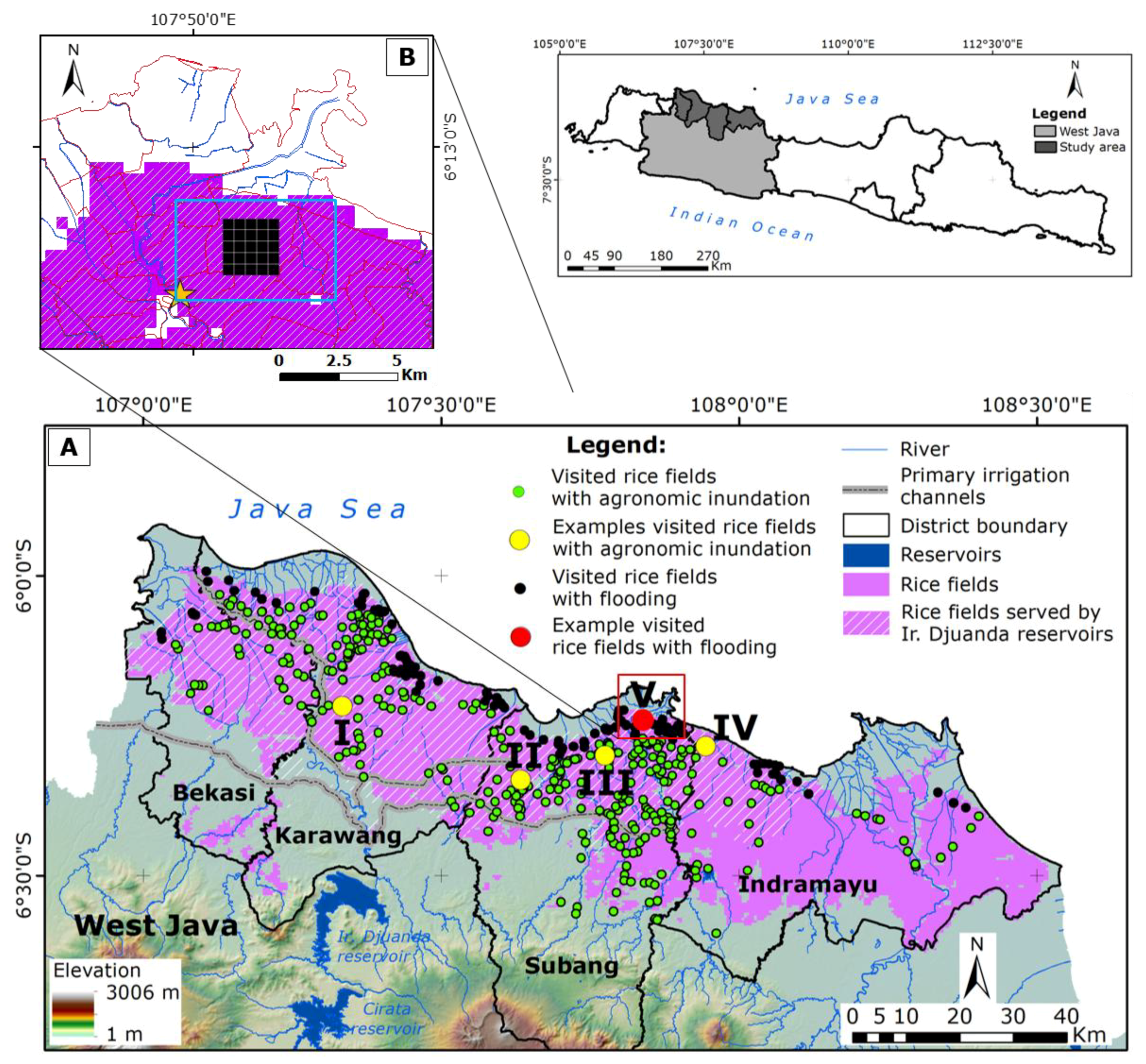
1.2. Study Area and Flooding Event 2014
2. Materials and Methods
2.1. Remote Sensing Data Pre-Processing
2.2. Fieldwork
- Direct evidence (dike breach): Rice fields in these villages were affected by flooding due to a dike failure on 18 January 2014. The same rice fields did not experience any flood events from January to February 2015. Farmers and extension officers mentioned a stark contrast between low and high rainfall intensities during 2014/2015 and 2013/2014 wet seasons, respectively.
- Physical conditions: These are swampland rice fields. Often, farmers who own swampland rice fields resort to coping with the risk of flooding by delaying the wet planting season until the end of February. The strategy is performed because it is almost impossible for farmers to drain ponding water from irrigated rice fields to hasten the start of rice cultivation during flooding periods. In other words, the start of wet planting seasons in these irrigated rice fields is partly controlled by physical conditions (e.g., rainfall, topography).
2.3. Distinguishing between Flooding and Agronomic Inundation
2.4. Accuracy Assessment
3. Results
3.1. EVI ≤ 0.1 for Distinguishing between Flooding and Agronomic Inundation
3.2. EVI40 for Distinguishing Flooding and Agronomic Inundation
3.3. Comparisons of Surface Water Areas
3.4. Accuracy Assessment
4. Discussion
5. Conclusions
Author Contributions
Funding
Acknowledgments
Conflicts of Interest
References
- Smith, L.C. Satellite remote sensing of river inundation area, stage, and discharge: A review. Hydrol. Process 1997, 11, 1427–1439. [Google Scholar] [CrossRef]
- Plate, E.J. Flood risk and flood management. J. Hydrol. 2002, 267, 2–11. [Google Scholar] [CrossRef]
- Klijn, F.; Kreibich, H.; de Moel, H.; Penning-Rowsell, E. Adaptive flood risk management planning based on a comprehensive flood risk conceptualisation. Mitig. Adapt. Strateg. Glob. Chang. 2015, 20, 845–864. [Google Scholar] [CrossRef]
- Sakamoto, T.; Van Nguyen, N.; Kotera, A.; Ohno, H.; Ishitsuka, N.; Yokozawa, M. Detecting temporal changes in the extent of annual flooding within the cambodia and the vietnamese mekong delta from MODIS time-series imagery. Remote Sens. Environ. 2007, 109, 295–313. [Google Scholar] [CrossRef]
- Son, N.T.; Chena, C.F.; Chen, C.R.; Chang, L.Y. Satellite-based investigation of flood-affected rice cultivation areas in Chao Phraya River Delta, Thailand. ISPRS J. Photogramm. Remote Sens. 2013, 86, 77–88. [Google Scholar] [CrossRef]
- Islam, A.S.; Bala, S.K.; Haque, M.A. Flood Inundation map of Bangladesh using MODIS time-series images. J. Flood Risk Manag. 2010, 3, 210–222. [Google Scholar] [CrossRef]
- Gao, B.-C. NDWI—A normalized difference water index for remote sensing of vegetation liquid water from space. Remote Sens. Environ. 1996, 58, 257–266. [Google Scholar] [CrossRef]
- McFeeters, S.K. The use of the normalized difference water index (NDWI) in the delineation of open water features. Int. J. Remote Sens. 1996, 17, 1425–1432. [Google Scholar] [CrossRef]
- Rogers, A.S.; Kearney, M.S. Reducing signature variability in unmixing coastal marsh thematic mapper scenes using spectral indices. Int. J. Remote Sens. 2004, 25, 2317–2335. [Google Scholar] [CrossRef]
- Kwak, Y.; Park, J.; Fukami, K. Estimating floodwater from MODIS time series and SRTM DEM data. Artif. Life Robot. 2014, 19, 95–102. [Google Scholar] [CrossRef]
- Xiao, X.; Boles, S.; Frolking, S.; Li, C.; Babu, J.Y.; Salas, W.; Moore, B., III. Mapping paddy rice agriculture in south and southeast Asia using multi-temporal MODIS images. Remote Sens. Environ. 2006, 100, 95–113. [Google Scholar] [CrossRef]
- Nguyen, T.T.H.; De Bie, C.A.J.M.; Ali, A.; Smaling, E.M.A.; Chu, T.H. Mapping the irrigated rice cropping patterns of the Mekong delta, Vietnam, through hyper-temporal SPOT NDVI image analysis. Int. J. Remote Sens. 2011, 33, 415–434. [Google Scholar] [CrossRef]
- Rouse, J.W.; Hass, R.H.; Schell, J.A.; Deering, D.W. Monitoring vegetation systems in the Great Plains with ERTS. In Proceedings of the 3rd Earth Resources Technology Satellite-1 Symposium, Washington, DC, USA, 10–14 December 1973; pp. 309–317. [Google Scholar]
- Gao, X.; Huete, A.R.; Ni, W.; Miura, T. Optical–biophysical relationships of vegetation spectra without background contamination. Remote Sens. Environ. 2000, 74, 609–620. [Google Scholar] [CrossRef]
- Huete, A.R.; Liu, H.Q.; Batchily, K.; Leeuwen, W.V. A comparison of vegetation indices over a global set of TM images for EOS-MODIS. Remote Sens. Environ. 1997, 59, 440–451. [Google Scholar] [CrossRef]
- Huete, A.; Didan, K.; Miura, T.; Rodriguez, E.P.; Gao, X.; Ferreira, L.G. Overview of the radiometric and biophysical performance of the MODIS vegetation indices. Remote Sens. Environ. 2002, 83, 195–213. [Google Scholar] [CrossRef]
- Miura, T.; Huete, A.R.; Yoshioka, H.; Holben, B.N. An error and sensitivity analysis of atmospheric resistant vegetation indices derived from dark target-based atmospheric correction. Remote Sens. Environ. 2001, 78, 284–298. [Google Scholar] [CrossRef]
- Jiang, Z.; Huete, A.R.; Didan, K.; Miura, T. Development of a two-band enhanced vegetation index without a blue band. Remote Sens. Environ. 2008, 112, 3833–3845. [Google Scholar] [CrossRef]
- Martinis, S.; Twele, A.; Strobl, C.; Kersten, J.; Stein, E. A multi-scale flood monitoring system based on fully automatic MODIS and TerraSAR-X processing chains. Remote Sens. 2013, 5, 5598–5619. [Google Scholar] [CrossRef]
- Ji, L.; Zhang, L.; Wylie, B. Analysis of dynamic thresholds for the normalized difference water index. J. Am. Soc. Photogramm. Remote Sens. 2009, 75, 1307–1317. [Google Scholar] [CrossRef]
- Sanyal, J.; Lu, X.X. Application of remote sensing in flood management with special reference to Monsoon Asia: A review. Nat. Hazards 2004, 33, 283–301. [Google Scholar] [CrossRef]
- Xiao, X.; Boles, S.; Liu, J.; Zhuang, D.; Frolking, S.; Li, C.; Salas, W.; Moore, B., III. Mapping paddy rice agriculture in southern China using multi-temporal MODIS images. Remote Sens. Environ. 2005, 95, 480–492. [Google Scholar] [CrossRef]
- Peng, D.; Huete, A.R.; Huang, J.; Wang, F.; Sun, H. Detection and estimation of mixed paddy rice cropping patterns with MODIS data. Int. J. Appl. Earth Obs. Geoinf. 2011, 13, 13–23. [Google Scholar] [CrossRef]
- Powell, S.J.; Jakeman, A.; Croke, B. Can NDVI response indicate the effective flood extent in macrophyte dominated floodplain wetlands? Ecol. Indic. 2014, 45, 486–493. [Google Scholar] [CrossRef]
- Boschetti, M.; Nutini, F.; Manfron, G.; Brivio, P.A.; Nelson, A. Comparative analysis of normalised difference spectral indices derived from MODIS for detecting surface water in flooded rice cropping systems. PLoS ONE 2014, 9, e88741. [Google Scholar] [CrossRef] [PubMed]
- Qiao, C.; Luo, J.; Sheng, Y.; Shen, Z.; Zhu, Z.; Ming, D. An adaptive water extraction method from remote sensing image based on NDWI. J. Indian Soc. Remote Sens. 2012, 40, 421–433. [Google Scholar] [CrossRef]
- Xiao, X.; Boles, S.; Frolking, S.; Salas, W.; Moore, B.; Li, C.; He, L.; Zhao, R. Observation of flooding and rice transplanting of paddy rice fields at the site to landscape scales in China using vegetation sensor data. Int. J. Remote Sens. 2002, 23, 3009–3022. [Google Scholar] [CrossRef]
- Massey, J.H.; Walker, T.W.; Anders, M.M.; Smith, M.C.; Avila, L.A. Farmer adaptation of intermittent flooding using multiple-inlet rice irrigation in Mississippi. Agric. Water Manag. 2014, 146, 297–304. [Google Scholar] [CrossRef]
- Qin, Y.; Xiao, X.; Dong, J.; Zhou, Y.; Zhu, Z.; Zhang, G.; Du, G.; Jin, C.; Kou, W.; Wang, J.; et al. Mapping paddy rice planting area in cold temperate climate region through analysis of time series Landsat 8 (OLI), Landsat 7 (ETM+) and MODIS imagery. ISPRS J. Photogramm. Remote Sens. 2015, 105, 220–233. [Google Scholar] [CrossRef] [PubMed]
- Dong, J.; Xiao, X.; Menarguez, M.A.; Zhang, G.; Qin, Y.; Thau, D.; Biradar, C.; Moore, B., III. Mapping paddy rice planting area in Northeastern Asia with Landsat 8 images, phenology-based algorithm and google earth engine. Remote Sens. Environ. 2016, 185, 142–154. [Google Scholar] [CrossRef] [PubMed]
- Datta, S.K.D. Principles and Practices of Rice Production; John Wiley & Sons: New York, NY, USA, 1981. [Google Scholar]
- Chau, V.N.; Holland, J.; Cassells, S.; Tuohy, M. Using GIS to map impacts upon agriculture from extreme floods in Vietnam. Appl. Geogr. 2013, 41, 65–74. [Google Scholar] [CrossRef]
- Mandal, R. Flood, cropping pattern choice and returns in agriculture: A study of Assam plains, India. Econ. Anal. Policy 2014, 44, 333–344. [Google Scholar] [CrossRef]
- Coomes, O.T.; Lapointe, M.; Templeton, M.; List, G. Amazon River flow regime and flood recessional agriculture: Flood stage reversals and risk of annual crop loss. J. Hydrol. 2016, 539, 214–222. [Google Scholar] [CrossRef]
- Sianturi, R.; Jetten, V. Towards understanding vulnerability: Investigating disruptions in cropping schedules in irrigated rice fields in west java. Int. J. Disaster Risk Reduct. 2018, 28, 335–349. [Google Scholar] [CrossRef]
- Qian, J.-H.; Robertson, A.W.; Moron, V. Interactions among ENSO, the monsoon, and diurnal cycle in rainfall variability over Java, Indonesia. J. Atmos. Sci. 2010, 67, 3509–3524. [Google Scholar] [CrossRef]
- Nuryanto, D.E.; Pawitan, H.; Hidayat, R.; Aldrian, E. Heavy rainfall distributions over java sea in wet season. Procedia Environ. Sci. 2016, 33, 178–186. [Google Scholar] [CrossRef]
- Sianturi, R.; Jetten, V.G.; Sartohadi, J. Mapping cropping patterns in irrigated rice fields in west java: Towards mapping vulnerability to flooding using time-series MODIS imageries. Int. J. Appl. Earth Obs. Geoinf. 2018, 66, 1–13. [Google Scholar] [CrossRef]
- Ali, A.; de Bie, C.A.J.M.; Skidmore, A.K. Detecting long-duration cloud contamination in hyper-temporal ndvi imagery. Int. J. Appl. Earth Obs. Geoinf. 2013, 24, 22–31. [Google Scholar] [CrossRef]
- Ali, A.; de Bie, C.A.J.M.; Skidmore, A.K.; Scarrott, R.G.; Lymberakis, P. Mapping the heterogeneity of natural and semi-natural landscapes. Int. J. Appl. Earth Obs. Geoinf. 2014, 26, 176–183. [Google Scholar] [CrossRef]
- Khan, M.R.; de Bie, C.A.J.M.; van Keulen, H.; Smaling, E.M.A.; Real, R. Disaggregating and mapping crop statistics using hypertemporal remote sensing. Int. J. Appl. Earth Obs. Geoinf. 2010, 12, 36–46. [Google Scholar] [CrossRef]
- Bie, C.A.J.M.D.; Nguyen, T.T.H.; Ali, A.; Scarrott, R.; Skidmore, A.K. Lahma: A landscape heterogeneity mapping method using hyper-temporal dataset. Int. J. Geogr. Inf. Sci. 2012, 26, 2177–2192. [Google Scholar] [CrossRef]
- Memon, A.A.; Muhammad, S.; Rahman, S.; Haq, M. Flood monitoring and damage assessment using water indices: A case study of pakistan flood-2012. Egypt. J. Remote Sens. Space Sci. 2015, 18, 99–106. [Google Scholar] [CrossRef]
- Campbell, J.B.; Wynne, R.H. Introduction to Remote Sensing, 5th ed.; The Guilford Press: New York, NY, USA, 2011. [Google Scholar]
- Congalton, R.G. A review of assessing the accuracy of classifications of remotely sensed data. Remote Sens. Environ. 1991, 37, 35–46. [Google Scholar] [CrossRef]
- Foody, G.M. Status of land cover classification accuracy assessment. Remote Sens. Environ. 2002, 80, 185–201. [Google Scholar] [CrossRef]
- Li, W.; Guo, Q. A new accuracy assessment method for one-class remote sensing classification. IEEE Trans. Geosci. Remote Sens. 2014, 52, 4621–4632. [Google Scholar]
- Powers, D.M.W. Evaluation: From precision, recall and f-measure to roc, informedness, markedness & correlation. J. Mach. Learn. Technol. 2011, 2, 37–63. [Google Scholar]
- Yan, Y.-E.; Ouyang, Z.-T.; Guo, H.-Q.; Jin, S.-S.; Zhao, B. Detecting the spatiotemporal changes of tidal flood in the estuarine wetland by using MODIS time series data. J. Hydrol. 2010, 384, 156–163. [Google Scholar] [CrossRef]


| Dates (WPS 1 2014) | Rice Field Condition (Interview) | Dates (WPS 2015) | Rice Field Condition (Fieldwork) |
|---|---|---|---|
| 17 January (DOY 017) | Flooding | 17 January (DOY 017) | Fallow |
| 25 January (DOY 025) | Flooding | 25 January (DOY 025) | Fallow |
| 2 February (DOY 032) | Flooding | 2 February (DOY 032) | Fallow |
| 10 February (DOY 041) | Flooding | 10 February (DOY 041) | Tillage |
| 18 February (DOY 049) | Flooding | 18 February (DOY 049) | Tillage |
| 26 February (DOY 057) | Flooding | 26 February (DOY 057) | Tillage |
| No | Date * | DOY | No | Date | DOY | No | Date | DOY |
|---|---|---|---|---|---|---|---|---|
| 1 | 08/08/2001 | 220 | 8 | 19/06/2006 | 170 | 15 | 06/22/2007 | 173 |
| 2 | 25/03/2004 | 84 | 9 | 05/07/2006 | 186 | 16 | 25/08/2007 | 237 |
| 3 | 31/07/2004 | 212 | 10 | 06/08/2006 | 218 | 17 | 26/09/2007 | 269 |
| 4 | 01/09/2004 | 244 | 11 | 22/08/2006 | 234 | 18 | 28/09/2008 | 271 |
| 5 | 02/07/2005 | 33 | 12 | 07/09/2006 | 250 | 19 | 01/08/2010 | 213 |
| 6 | 04/09/2005 | 247 | 13 | 09/10/2006 | 282 | |||
| 7 | 16/04/2006 | 106 | 14 | 25/10/2006 | 298 |
| Method and Formula | ||
|---|---|---|
| True Positive: flooding is correctly identified as flooding; SOSx a − SOSz b > 25 days | True Positive Rate or Sensitivity or Recall: TP d/(TP+FN e) | Positive Predictive Value or Precision: TP/(TP+FP) |
| False Positive: agronomic inundation is incorrectly identified as flooding; SOSy c − SOSz > 25 days | False Positive Rate: FP/(FP+TN) | Negative Predictive Value: TN/(TN+FN) |
| True Negative: agronomic inundation is correctly identified as agronomic inundation; SOSy − SOSz ≤ 25 days | True Negative Rate or Specificity: TN f/(FP g+TN) | Accuracy: (TP+TN)/(TP+FP+TN+FN) |
| False Negative: flooding is incorrectly identified as agronomic inundation; SOSx − SOSz ≤ 25 days | False Negative Rate: FN/(FN+TP) | F1 Score: 2TP/(2TP+FP+FN) |
| Agronomic Inundation (n-total = 1287) | Flooding (n-total = 284) | ||||
|---|---|---|---|---|---|
| 2015 * (n = 42) 25 ± 11 | 2014 (n = 49) 24 ± 11 | 2013 (n = 79) 30 ± 9 | 2012 (n = 89) 27 ± 10 | 2011 (n = 90) 29 ± 10 | Swampland rice fields 2015 * (n = 133) 60 ± 22 |
| 2010 (n = 87) 27 ± 11 | 2009 (n = 93) 27 ± 11 | 2008 (n = 99) 25 ± 12 | 2007 (n = 88) 22 ± 11 | 2006 (n = 98) 21 ± 9 | 2014 (n = 90) 83 ± 22 |
| 2005 (n = 95) 24 ± 11 | 2004 (n = 72) 26 ± 12 | 2003 (n = 101) 25 ± 11 | 2002 (n = 104) 27 ± 10 | 2001 (n = 101) 28 ± 9 | Dyke failure event 18 January 2014 * (n = 61) 95 ± 20 |
| Reference Data | ||||
|---|---|---|---|---|
| Agronomic Inundation | Flooding | Total | ||
| Classified image | Non-hazardous agronomic inundation | 344 | 46 | 390 |
| Hazardous flooding | 93 | 230 | 323 | |
| total | 437 | 276 | 713 | |
| Overall Accuracy | 80.5% | Kappa | 60.16% | |
| Producer’s Accuracy | Omission error | User’s Accuracy | Commission error | |
| Non-hazardous agronomic inundation | 78.71% | 21.29% | 88.2% | 11.8% |
| Hazardous flooding | 83.3% | 16.7% | 71.2% | 28.8% |
| 5 × 5 pixels (n = 1918) | Methods | |
|---|---|---|
| True Positive: 1032 | True Positive Rate or Sensitivity or Recall: 82.49% | Positive Predictive Value or Precision: 81% |
| False Positive: 242 | False Positive Rate or Fall out: 36.28% | Negative Predictive Value: 65.99% |
| True Negative: 425 | True Negative Rate or Specificity: 63.72% | Overall Accuracy: 75.96% |
| False Negative: 219 | False Negative Rate or Miss Rate: 17.51% | F1 Score: 81.74% |
© 2018 by the authors. Licensee MDPI, Basel, Switzerland. This article is an open access article distributed under the terms and conditions of the Creative Commons Attribution (CC BY) license (http://creativecommons.org/licenses/by/4.0/).
Share and Cite
Sianturi, R.; Jetten, V.G.; Ettema, J.; Sartohadi, J. Distinguishing between Hazardous Flooding and Non-Hazardous Agronomic Inundation in Irrigated Rice Fields: A Case Study from West Java. Remote Sens. 2018, 10, 1003. https://doi.org/10.3390/rs10071003
Sianturi R, Jetten VG, Ettema J, Sartohadi J. Distinguishing between Hazardous Flooding and Non-Hazardous Agronomic Inundation in Irrigated Rice Fields: A Case Study from West Java. Remote Sensing. 2018; 10(7):1003. https://doi.org/10.3390/rs10071003
Chicago/Turabian StyleSianturi, Riswan, Victor G. Jetten, Janneke Ettema, and Junun Sartohadi. 2018. "Distinguishing between Hazardous Flooding and Non-Hazardous Agronomic Inundation in Irrigated Rice Fields: A Case Study from West Java" Remote Sensing 10, no. 7: 1003. https://doi.org/10.3390/rs10071003
APA StyleSianturi, R., Jetten, V. G., Ettema, J., & Sartohadi, J. (2018). Distinguishing between Hazardous Flooding and Non-Hazardous Agronomic Inundation in Irrigated Rice Fields: A Case Study from West Java. Remote Sensing, 10(7), 1003. https://doi.org/10.3390/rs10071003


