1. Introduction
As a recurring natural process, fire has been a basic element in preserving the health and biodiversity of numerous terrestrial ecosystems for thousands of years [
1,
2,
3]. However, any alteration to this nature-driven dynamic, due either to direct anthropogenic actions or as a result of global warming, can give rise to situations where fire can become a significant disturbance for many ecosystems, causing feedbacks on global warming, regionally and globally, in turn. Prominent amongst said disturbances are the loss of biodiversity due to the decimation of species and biomass [
2]; soil deterioration and erosion which, alongside the change in land cover (terrestrial albedo) [
4,
5], alter water and energy flows; and the emission of large amounts of aerosols and greenhouse gases affecting the carbon cycle and global warming [
6,
7,
8,
9]. For all the above, several international climate research teams—chiefly members of the Global Climate Observing System (GCOS)—have identified Fire Disturbance as an Essential Climate Variable (ECV) that critically contributes to the characterization of Earth’s climate.
The Fire Disturbance ECV consists of three variables: Burned Area, Active Fires and Fire Radiated Power [
10]. Amongst them, Burned Area is deemed the main variable [
11] and, therefore, its tracking becomes imperative, in order to forecast and understand the Earth’s climate evolution, as well as to take the necessary steps to mitigate its negative effects. But Burned Area maps are also necessary in other applications of vital interest to our society as an early warning fire alert system; the fire hazard assessment for ecosystems management; the study of changes in atmospheric chemistry; and in biogeochemical modelling and that of the vegetation dynamics at a global scale [
12].
It is not easy to gather time-consistent Burned Area data for periods exceeding 30 years for climate-related studies. Only sensors onboard the Earth observation satellites—primarily polar orbit satellites, which boast better spatial resolution (≤1000 m) than the geostationary orbit ones (>1000 m)—could provide images of areas affected by the fire at a local, regional, and global level, allowing for the registry of their distribution and occurrence patterns [
13].
Of all remote sensors, the only one that has been taking daily images of our planet from the early 1980s is Advanced Very High Resolution Radiometer (AVHRR) onboard the series of NOAA (National Oceanic and Atmospheric Administration) satellites, whose data have made it possible to develop various algorithms to assess fire effects [
14,
15,
16,
17,
18,
19,
20,
21,
22,
23]. Other widely used sensors in Burned Area mapping at a regional and global level have been VEGETATION (VGT) onboard SPOT (Systeme Pour I’Observation de la Terre) 4 and 5 satellites [
24,
25,
26,
27], and Moderate Resolution Imaging Spectrometer (MODIS) onboard NASA’s Terra and Aqua satellites. MODIS, with excellent temporal resolution (12 h) owing to the combination of two satellites, spectral resolution (36 bands) and spatial resolution (250–1000 m), has allowed for the development of various Burned Area detection algorithms that have been globally applied to and assessed in diverse ecosystems, ranging from tropical to boreal [
28,
29,
30,
31,
32,
33,
34].
For local Burned Area studies, sensors with a 30 m spatial resolution, such as those of Landsat Project—a joint initiative between the U.S.A. Geological Survey (USGS) and NASA—are normally used. These include Landsat 5 TM (Thematic Mapper) from March 1984 to November 2012; Landsat 7 ETM (Enhance Thematic Mapper) since 1999, still operational; and Landsat 8 OLI (Optical Land Imager) and TIRS (Thermal Infrared Sensor), in orbit since 11 February 2013 [
35]. Landsat images have also been traditionally used to validate Burned Area algorithms developed with sensors showing coarser spatial resolution [
26,
28,
36,
37,
38,
39,
40,
41,
42,
43].
There are several global Burned Area products obtained from the data provided by remote sensors [
12,
44]. These products are free to access, but not all them are operational or cover long temporal series despite the sensors used having had or having a longer lifespan. This is the case of GBS (Global Burned Surfaces) [
45], which is limited to the 1982–1999 period. GBS used Pathfinder AVHRR Land (PAL) data at an 8 km spatial resolution. Based on another sensor, SPOT-VGT, we find three Burned Area products: GBA2000 [
46], specifically designed for the year 2000; L3JRC [
47], available for the April 2000–March 2007 period; and GEOLAND2 [
48], based on the previous two and with data available from April 1999 to March 2014. GEOLAND2 has currently been adapted to sensor PROBA-V, with a 300 m spatial resolution. PROBA-V’s spectral bands are similar to those of the VGT, thereby preserving an observational consistency with its predecessor. Two other Burned Area products from European satellites were GLOBCARBON, obtained through a combination of the VGT sensor and the ATSR instrument (Along Track Scanning Radiometer) [
49] for the April 1998–December 2007 period, and GLOBSCAR, from ATSR-2 images [
50].
Two of the most reliable global Burned Area products, MCD45A1 [
51] and MCD64A1 [
52], have been generated from MODIS Aqua and Terra images, with maps made available from the year 2000 onwards. Both are monthly Level 3 gridded 500 m products containing per-pixel burning and quality information, and tile-level metadata. Another product that has been using MODIS data from the year 2000 is Global Fire Emissions Database (GFED) [
31], which estimates Burned Area and monthly emissions of various fire types with a 0.25° latitude by 0.25° longitude spatial resolution. GFED have available data from 1997 through to the present, for which reason it is regarded as the longest Burned Area temporal series [
31]. Active fire data from the Tropical Rainfall Measuring Mission (TRMM) Visible and Infrared Scanner (VIRS), and the Along-Track Scanning Radiometer (ATSR) were used to get GFED where MODIS data was not available yet [
53].
Finally, it is worth mentioning the European Project Fire_cci’s Burned Area dataset [
12]. Fire_cci Burned Area has been obtained by combining temporal changes in reflectance from Medium Resolution Imaging Spectrometer (MERIS) onboard the ESA ENVISAT satellite and thermal information on active fires from MODIS, for the years 2005 to 2011, as monthly composites. The main advantage of the Burned Area Fire_cci product could be the improvement in detection of small fires by increasing the spatial resolution to 300 m with respect to MODIS Burned Area products [
43]. In a second stage, Fire_cci will cover the time series 2000–2017, with a spatial resolution between 250 and 500 m, depending on the sensor being used [
54].
Studies comparing the accuracy of global Burned Area products, discussed in the previous paragraphs, prove that there are appreciable differences between them in many regions of our planet [
12,
23,
31,
33,
43,
55,
56]. This way, using these products in applications at a local or regional level calls for previously validated studies in order to know the exact commission and omission errors and decide whether or not they may be used as input data for climate models and vegetation dynamics in line with the current requirements. It is hard to connect globally developed algorithms for a specific sensor with the various ecosystems affected by fires at different latitudes.
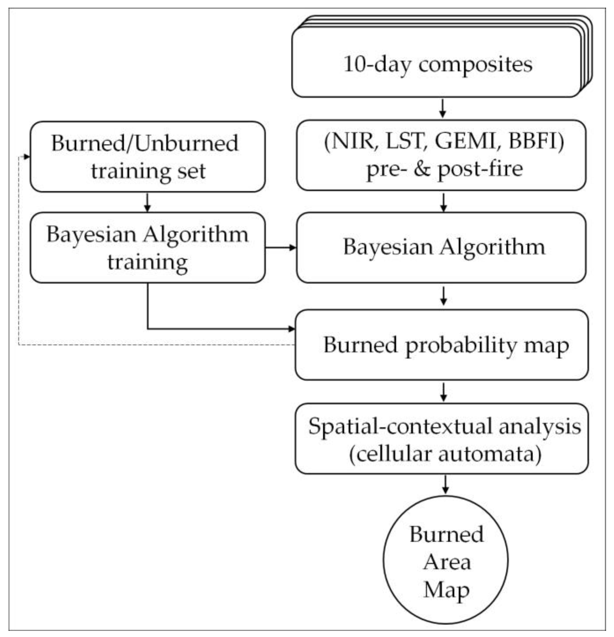
An algorithm for mapping Burned Area in boreal forests was developed as part of a researching project supported in part by the Spanish Ministry of Science and Innovation [
23]. It used AVHRR archival data Long Term Data Record (LTDR) version 3, with 0.05° of spatial resolution and was applied to western Canada for the period between 1984 and 1999. Fire event records from Canadian Forest Service National Fire Database (CFSNFD) were used to train the algorithm. The kernel of the algorithm is a Bayesian network classifier, combined with absolute and relative radiometric thresholds, and a post-processing step (neighbourhood analysis) for spatial fire coherence. A chain of software tools was built in order to implement the algorithm and automate the processing from the daily images in their original format to 10 day Burned Area maps. The algorithm was successfully evaluated against reference data and with Burned Area records generated from 1 km AVHRR data by [
22]. The same Bayesian network algorithm was applied to mapping Burned Area in the North American boreal region for the years 1984–1998 using the AVHRR-LTDR dataset version 3, and two training sites (Western Canada and Alaska). The results showed an overall good agreement compared to reference maps derived from CFSNFD and Alaska Fire Service (AFS), and comparable results for both training sites [
57]. Later, a Burned Area time series (2001–2011) for North America from the MODIS-LTDR dataset version 3 was successfully built as a continuation of the previous time series applying the same methodology, but using the MODIS Brightness Temperature from band 31 T31 (11.03 μm) instead of the AVHRR Top of Atmosphere Brightness Temperature from band 3 (3.7 μm). The results obtained were even better than those derived from other Burned Area products, with higher spatial resolution (MCD45A1 and GEOLAND2) in terms of spatial and temporal accuracy, and comparable with the MCD64A1 Burned Area product [
58].
This paper presents the application of the above methodology [
23,
57,
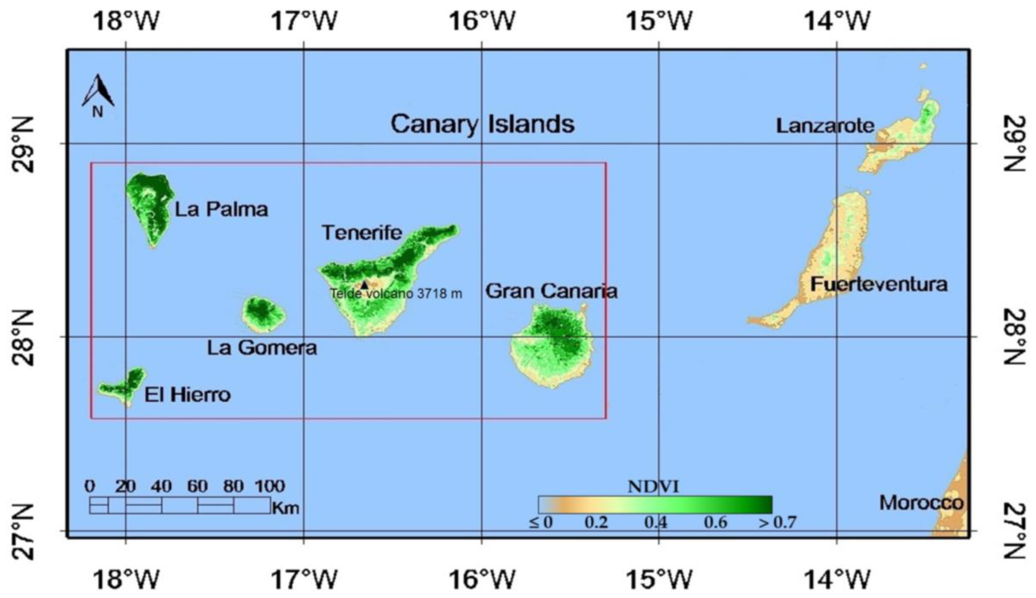
58] to a lower latitude forest ecosystem, totally different from the boreal ecosystem and using daily time series of satellite images from MODIS with a 250 m spatial resolution. The main objectives are: (i) to build a 10 day composite time series of MODIS satellite images using the maximum surface temperature criterion, for the 2002–2012 period in a Mediterranean forest region (the Canary Islands); (ii) to generate Burned Area maps corresponding to the study region using the methodology based on the Bayesian classifier and the same variables, although modifying the values of its parameters by training with reference data extracted from official fire records and post-fire Landsat images; and (iii) to assess the spatial and temporal accuracy of the detected Burned Area with reference data, and to compare the results with those of the official MODIS Burned Area products with analogous spatial resolution (MCD45A1 and MCD64A1).
4. Discussion
All products, BY-MODIS, MCD45A1, and MCD64A1, including LANDSAT, underestimated the total Burned Area for the set of fourteen fires over 100 ha recorded in the study region for the 2002–2012 period. The difference between the total Burned Area according to MAPAMA and the LANDSAT polygons may be due to the existence of islands of unburned vegetation in the official product, but also to the construction of the LANDSAT polygons with images that, in some cases, differ months from the date of the fire. Regardless of the algorithmic strategy used to tell burned and non-burned pixels apart, all methods are normally designed to be as accurate as possible; that it to say, to obtain low commission errors, even if that means omitting a larger number of burned pixels [
39,
79]. In this respect, results of this study are in agreement with most previous published works using MODIS data for various regions and ecosystems [
33,
34,
39,
58,
80,
81,
82,
83,
84,
85,
86,
87,
88]. However, a great variability was found in Burned Area percentages detected by the products under consideration for the various fires (
Table 5 and
Table 6).
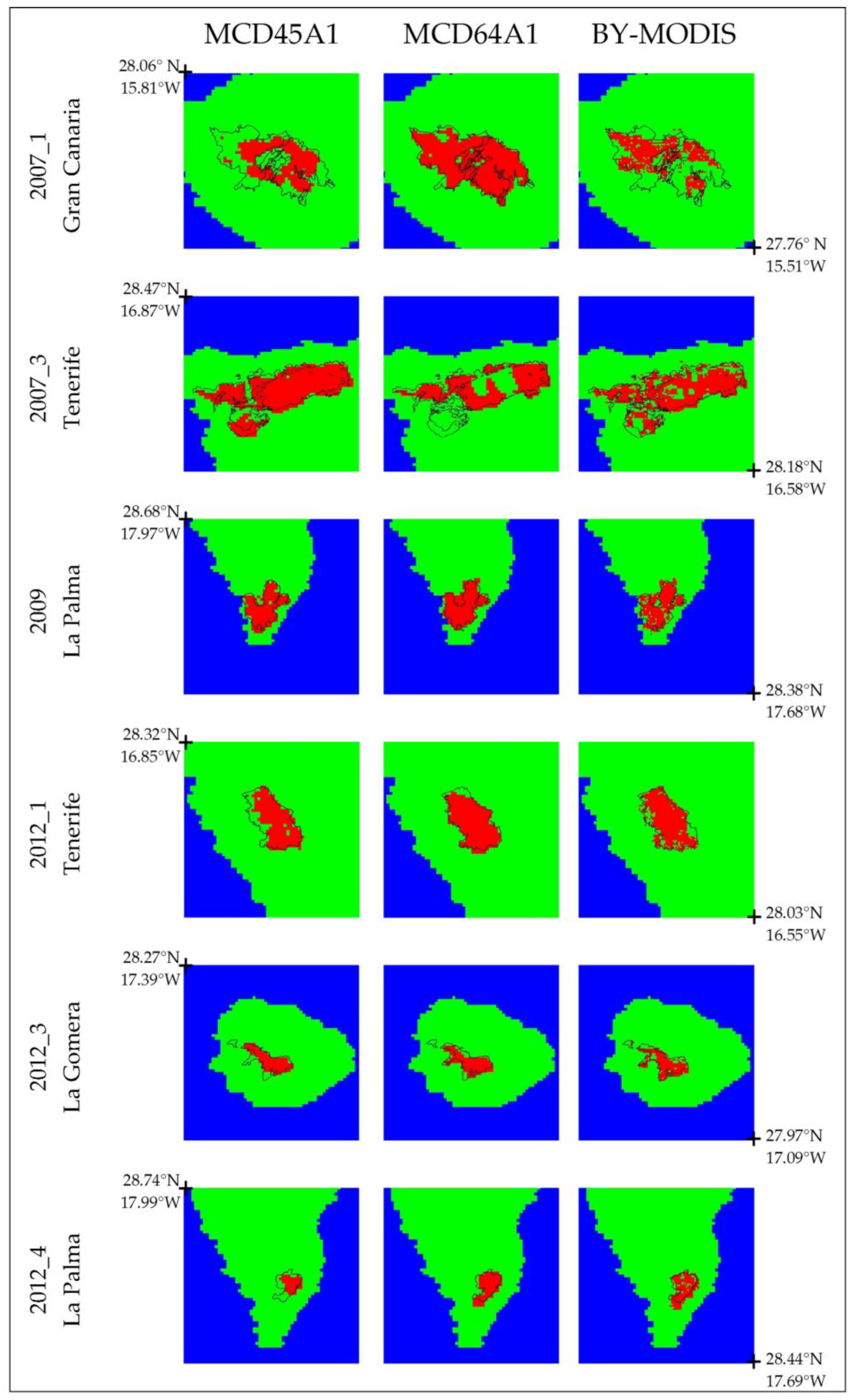
There are no precedents in the literature about the use of MODIS Burned Area products in the Canary Islands region to analyse a historical series of over ten years, such as the one discussed in this work. Only a few studies have been published on the two large fires that occurred simultaneously in 2007 in Tenerife and Gran Canaria [
89,
90]. For this reason, our results were compared and discussed with works conducted on Mediterranean ecosystems similar to the Canary Islands and those that included fires in regions of topographic complexity. We cannot ignore the fact that the five western islands of the Canarian Archipelago historically affected by forest fires show a highly rugged terrain of a volcanic origin, with numerous narrow ravines scoring them radially which, in many cases, may disguise the correct sensing of burned areas with the spatial resolution of MODIS products [
34,
91].
Analysis of the temporal accuracy proved that annual distribution of Burned Area for the BY-MODIS, MCD45A1, and MCD64A1 products shows a good correlation with the reference set, resulting in determination coefficients (R
2) of 0.82, 0.81, and 0.88, respectively (
Table 7). Similarly to results found by Moreno-Ruiz et al. [
58] in the North American Boreal Forest, the year 2006 presented the biggest errors, both in terms of accuracy (
Table 7) and spatial precision (
Table 8), for the BY-MODIS and MCD45A1 products. By contrast, 2006 was found to be one of the years with the best results for the MCD64A1 product. This fact can be observed in the fire that occurred in the island of El Hierro in September 2006 (
Table 5,
Table 7 and
Table 8). In this case, both BY-MODIS and MCD45A1, with omission errors greater than 98%, were hardly able to sense a single burned pixel within the fire polygon, compared to MCD64A1, with only a 2% omission error and a 24% commission error, possibly due to the identification of isolated regions of bare volcanic ground as burned areas. The use of active fires in the MCD64A1 provides very valuable information to correctly estimate the Burned Area in such cases, where the affected vegetation is basically comprised of Canarian pine trees (conifers) with a forest canopy cover ranging from 60% to 90% and under water stress. Three consecutive months without rainfall and with hot temperatures, alongside intense and long-lasting southerly winds (information retrieved from
http://www.aemet.es/es/lineas_de_interes/datos_y_estadistica), led to a relative humidity lower than 20% (whereas, under normal conditions, it exceeds 70%), which made it easier for the fire to spread in just six hours. This situation makes it harder for BY-MODIS or MCD45A1 products, which are based on algorithms seeking to sense drastic changes in post-fire reflectances, to be effective for this fire. Tsela et al. [
82] obtained comparable results for pine forest plantations in Sabie (South Africa), with omission errors exceeding 80%.
The year 2005 failed to record satisfactory results for either of the products, with omission errors of 39% for MCD64A1 and of 69% for MCD45A1. The fire dominating statistics for this year corresponded to the one in the north of the island of La Palma, with a 1890 ha Burned Area, according to official figures. The fire affected an area of approximately 7 km long, west-to-east, by 3 km long, north-to-south, but with an altitude variation of over 1000 m in the latter—from 1000 to 2000 m above the sea level—and essentially burned the Canarian pine forest in the lower part and brushwood in the higher part. The steep land, with a highly rugged terrain and deep ravines filled with shade areas, made it difficult to map the Burned Area for all products, as other authors previously pointed out in a mountainous area of Northwest Yunnan (China) [
34] or for the fynbos, a Mediterranean shrubland of the southwestern area of South Africa [
85,
92]. The same argument would be valid to explain big commission and omission errors (
Table 8) for the only fire occurred during the year 2008. The 376 affected hectares were located in the north of the island of La Gomera. The area shows a highly heterogeneous coverage, including numerous farming allotments, brushwood, palm trees and heaths located on a topographically complex terrain, making its modelling in two dimensions—using MODIS sensors’ spatial resolution—difficult.
In regard to spatial accuracy of the burned areas estimates, the overall linear regression slope between the results for the BY-MODIS, MCD64A1, and MCD45A1 products, and the reference dataset (
Table 7) were similar, with values of 0.76, 0.93, and 0.81, respectively, and are also in line with the results obtained by [
79] for the MCD45A1 product. These authors [
79] validated MCD45A1 in six different regions with Mediterranean ecosystems in the year 2003. They obtained a commission error of 17.4%, and an omission error of 38.6%, with a 0.79 slope and a 0.84 determination coefficient. However, these results are a long way from the validations conducted by authors [
41] for the MCD45 product for Mediterranean Forest biome, with characteristics similar to those of our case study, with commission errors of 69% and omission errors of 95%.
In general, BY-MODIS and MCD45A1 commission and omission errors are similar, but slightly different to those of MCD64A1. The total omission error for the MCD64A1 was around 10% lower than in the other two products. Those results are comparable to those obtained by the authors in the boreal forest region of North America using the same BA algorithm on daily images from the LTDR dataset [
33,
57].
Another noteworthy difference of the MCD64A1 product with respect to BY-MODIS and MCD45A1 was its difficulty to sense small fires. This product failed to identify a single pixel as burned in the five fires with fewer than 400 ha. Similar findings were reported by Tsela et al. [
82], who suggested the combination of the two MODIS BA products (MCD45A1 and MCD64A1) would improve detection of small burned scars in South Africa. Fornacca et al. [
34] also report the worse performance of MCD64A1 in the detection of small burned areas in the mountainous region of Yunnan (China) in the years 2006 and 2009, compared to the product that does not use active fires (MCD45A1).
For the largest fires (>2000 ha), although the best total performance corresponded to the MCD64A1 product in both, in the estimated accuracy and spatial precision, we observe a high variability for the Burned Area detected for these fires (
Figure 4,
Table 9). For the 2007_1 fire—the largest fire, greater than 18,000 ha—MCD64A1 obtained the best Burned Area estimation, twice above the other BA products, which led to an unavoidable bias in favour of this product in global statistics (
Table 9). In this case, the Burned Area mainly corresponded to herbaceous and non-wooded vegetation by 63%. The fire took place in the southern slope of the island of Gran Canaria, an area with little forest coverage which is very arid all year round. Once again, the MCD64A1 methodology with active fires allowed for a better total estimation according to the reference set, compared to the other two products. Conversely, for the second largest fire, the 2007_3, which took place mainly in the northern slope of the island of Tenerife, largely affecting a dense and wet Canarian pine tree forest, both BY-MODIS and MCD45A1 improved on MCD64A1 results. The cause could be rooted in the thick smoke and steam produced during biomass combustion, preventing active fires in the central part of the Burned Area from being recorded. There were no remarkable differences between the three products for the remaining big fires.
5. Conclusions
We have evaluated a Bayesian Algorithm (BY-MODIS) to detect burned areas in the Canary Islands’ dry woodlands and forests ecoregion using daily time series of satellite images from MODIS with a 250 m spatial resolution. The results obtained by BY-MODIS were compared with MODIS databased Burned Area products MCD64A1 Version 6 and MCD45A1 Version 5.1 for the 2002–2012 period. This is the first study dedicated to mapping burned areas for such a long period of time in this particular region.
Despite these islands’ topographic complexity and the diverse type of ecosystems affected by the fire found in such a small and fragmented territory, BY-MODIS and the other two products are capable of offering good temporal accuracy when assessed with reference datasets, resulting in determination coefficients (R2) of 0.82, 0.81, and 0.88, for the BY-MODIS, MCD45A1, and MCD64A1, respectively. In regard to spatial accuracy, the Burned Area was underestimated in all products. However, the results should be separated according to the size of the fires. For fires bigger than 2000 ha, the best total performance corresponded to the MCD64A1 product outperforming the other two products by approximately 10%. The use of active fires seems to provide very valuable information to correctly estimate the Burned Area in such cases. On the other hand, the MCD64A1 could not detect any of the five fires with less than 400 ha, being BY-MODIS, the algorithm with the best estimated accuracy and spatial precision in this case. BY-MODIS and MCD45A1 products, which are based on algorithms seeking to sense drastic changes in post-fire reflectances, are effective for these small fires. Taking into account both spatial accuracy in fires of any size and its applicability to the assorted sizes within the period under consideration, BY-MODIS can be regarded as a reliable alternative to MCD54A1 and MCD64A1 products.
The results of this study prove the capacity to adapt and the versatility of a Bayesian algorithm—previously developed and successfully applied to regions in the boreal forest—in other regions showing different ecosystems and satellite images with diverse spatial resolution, as long as a set of training areas adequately characterising the dynamics of the forest canopy affected by the fire is defined.


 ,
, 


