Analysis of Secular Ground Motions in Istanbul from a Long-Term InSAR Time-Series (1992–2017)

 ,
,  , ,
, ,
Abstract
:1. Introduction
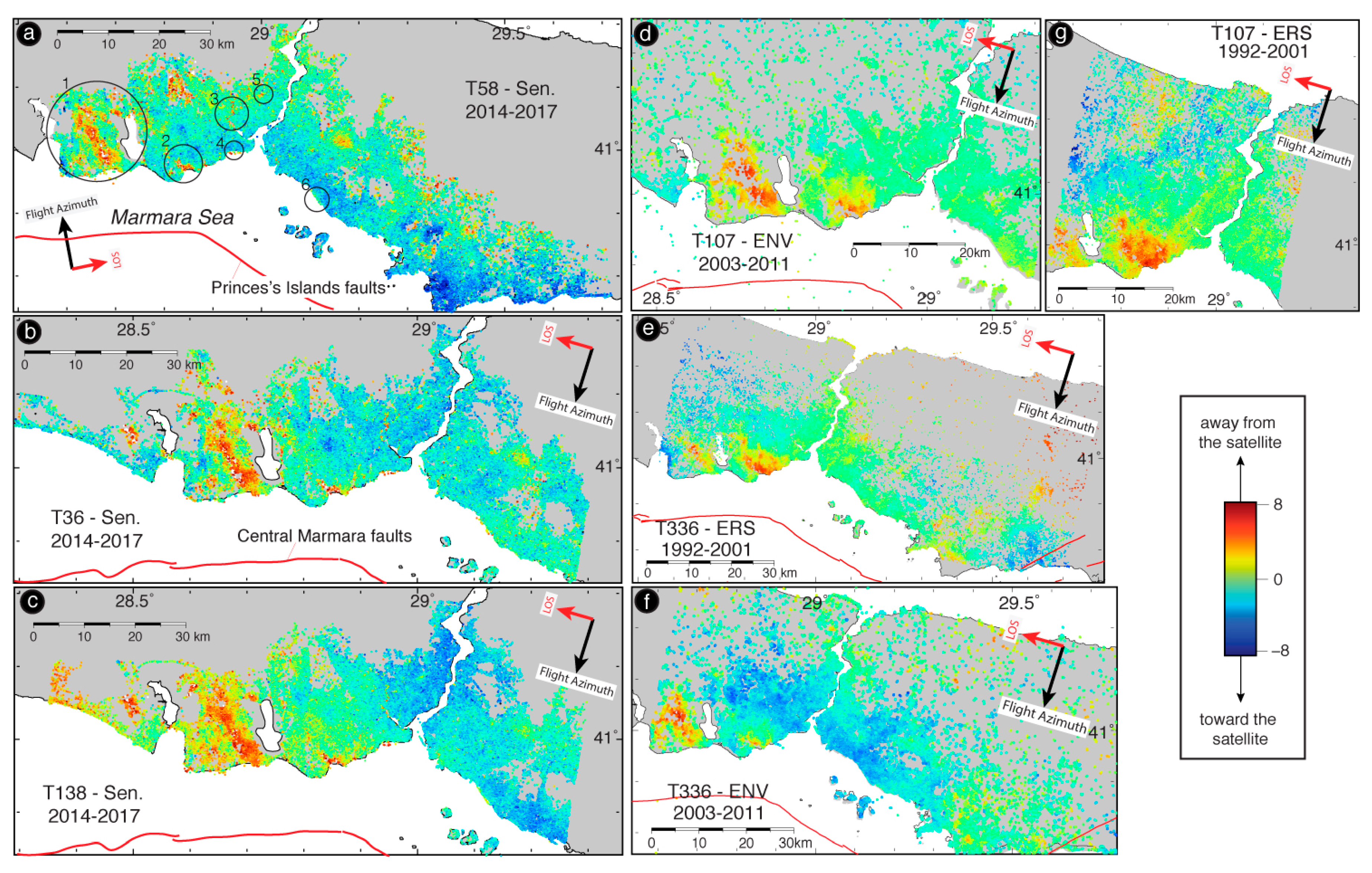
2. Background of the Study Areas
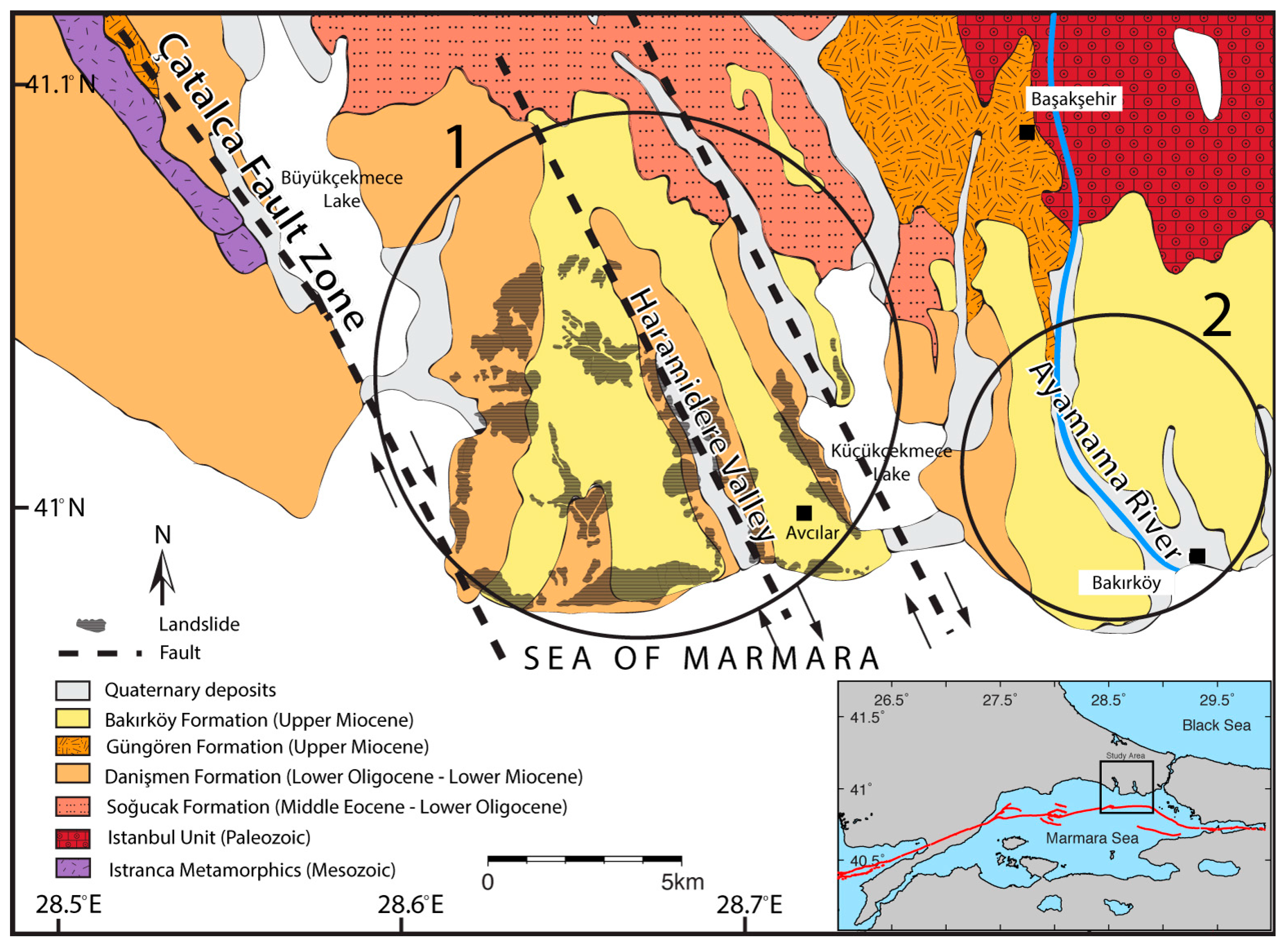
2.1. Geological Setting of Study Areas 1 and 2
2.2. Study Area 1: Haramidere Valley and Avcilar Neighborhood
2.3. Study Area 2: Ayamama River Valley
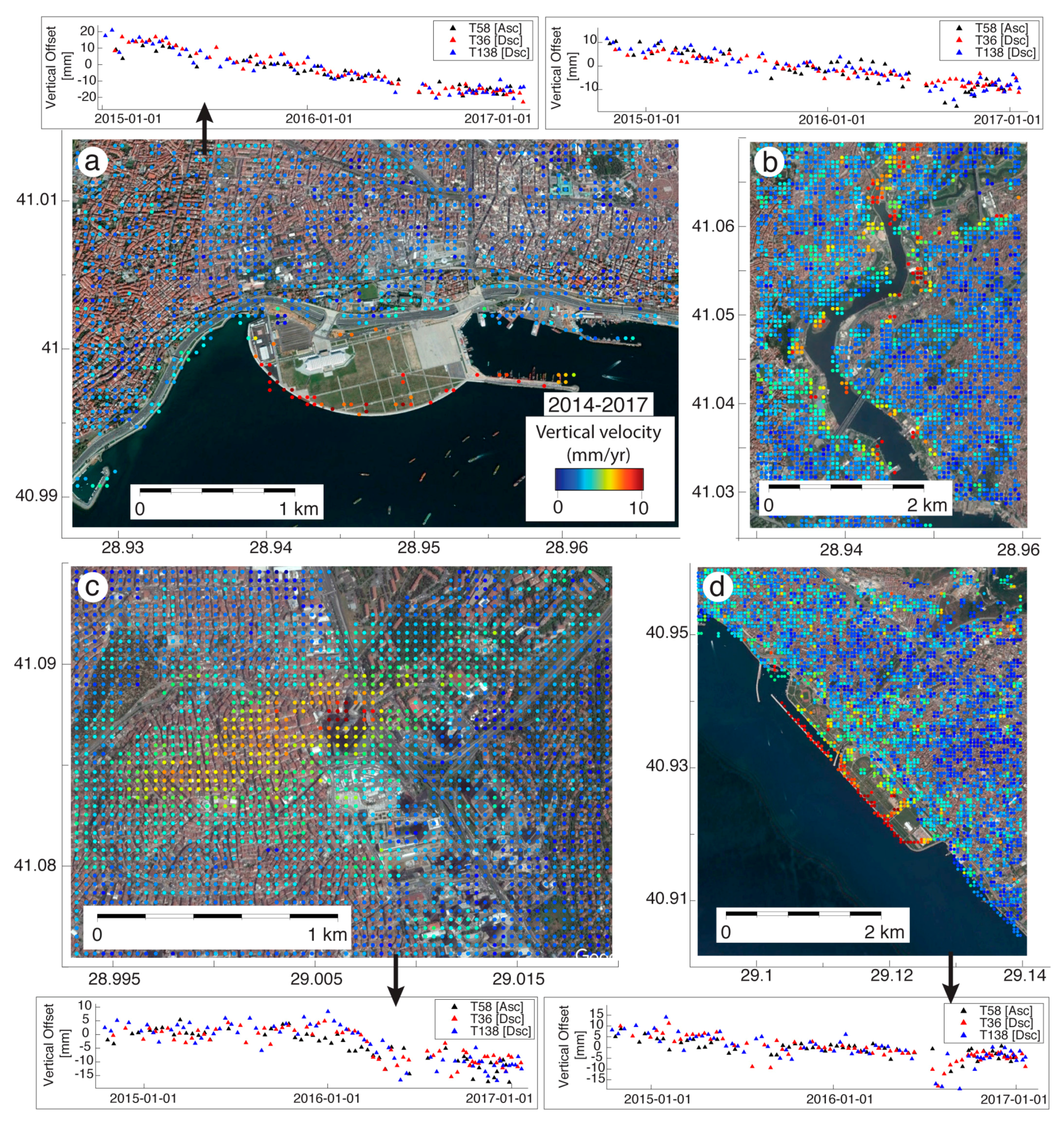
2.4. Study Areas 3 to 6: Subsidence Events Associated with Land Reclamation and Urbanisation
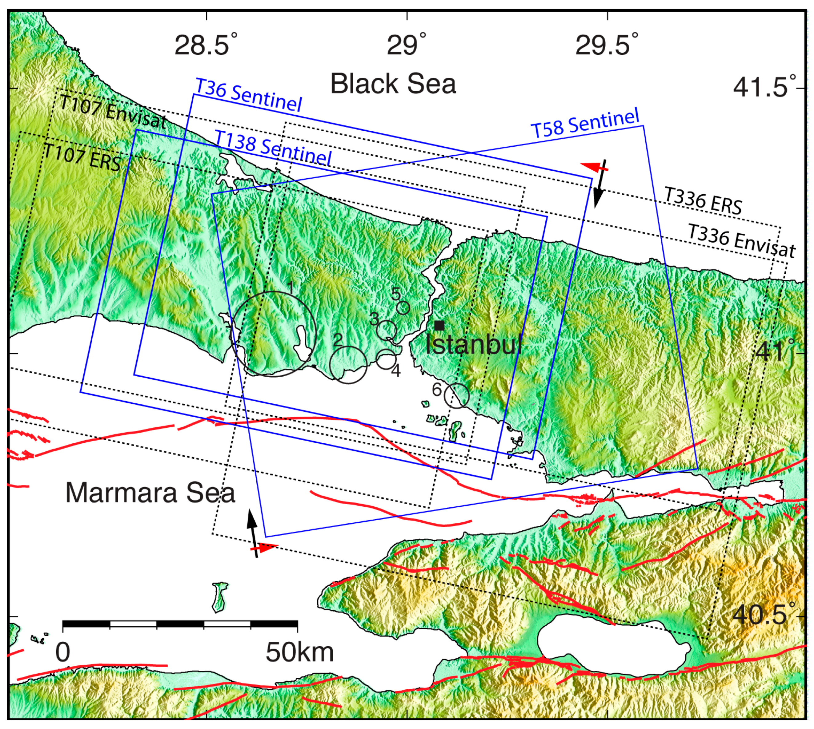
3. Datasets and Methodology
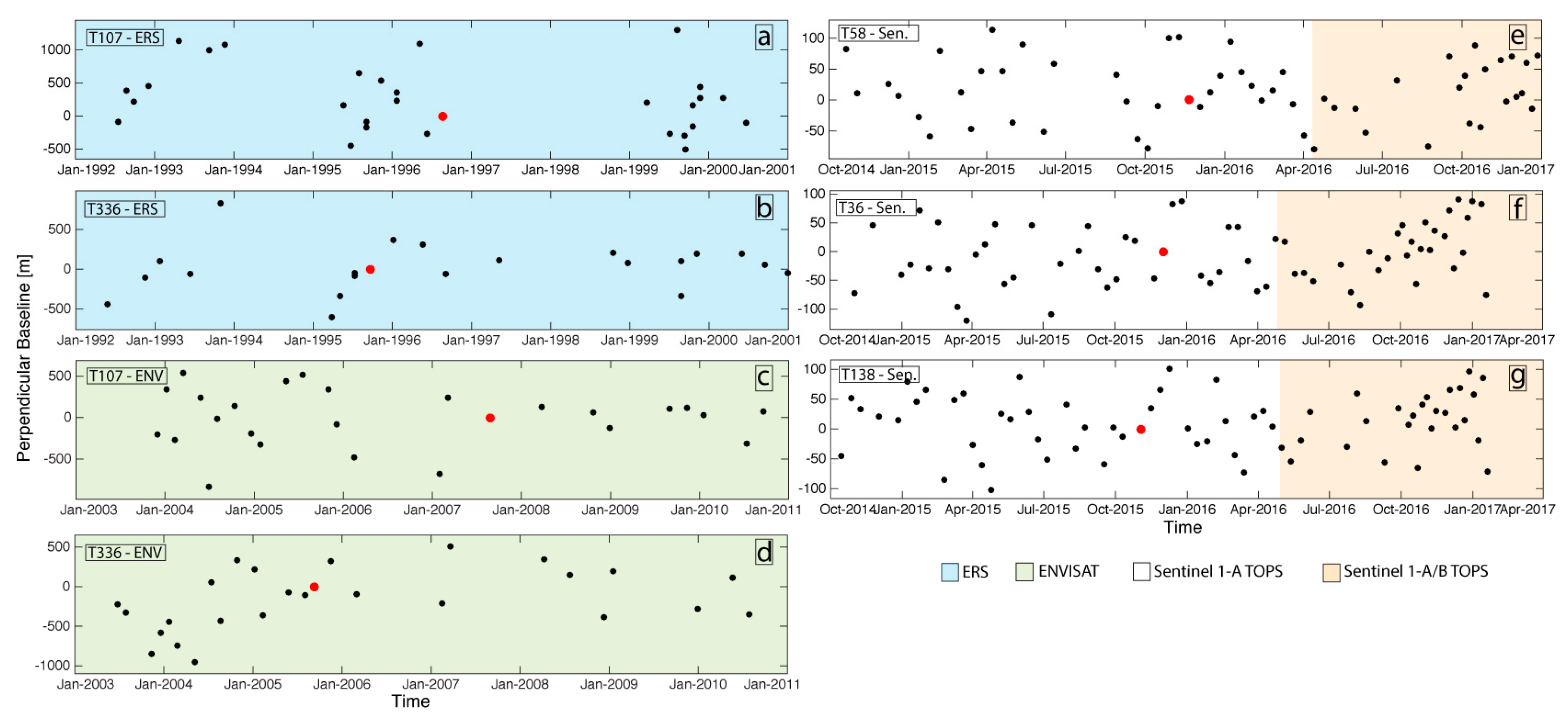
3.1. Datasets
3.2. Methodology
4. Results
InSAR-Derived Land Subsidence Maps
5. Discussion
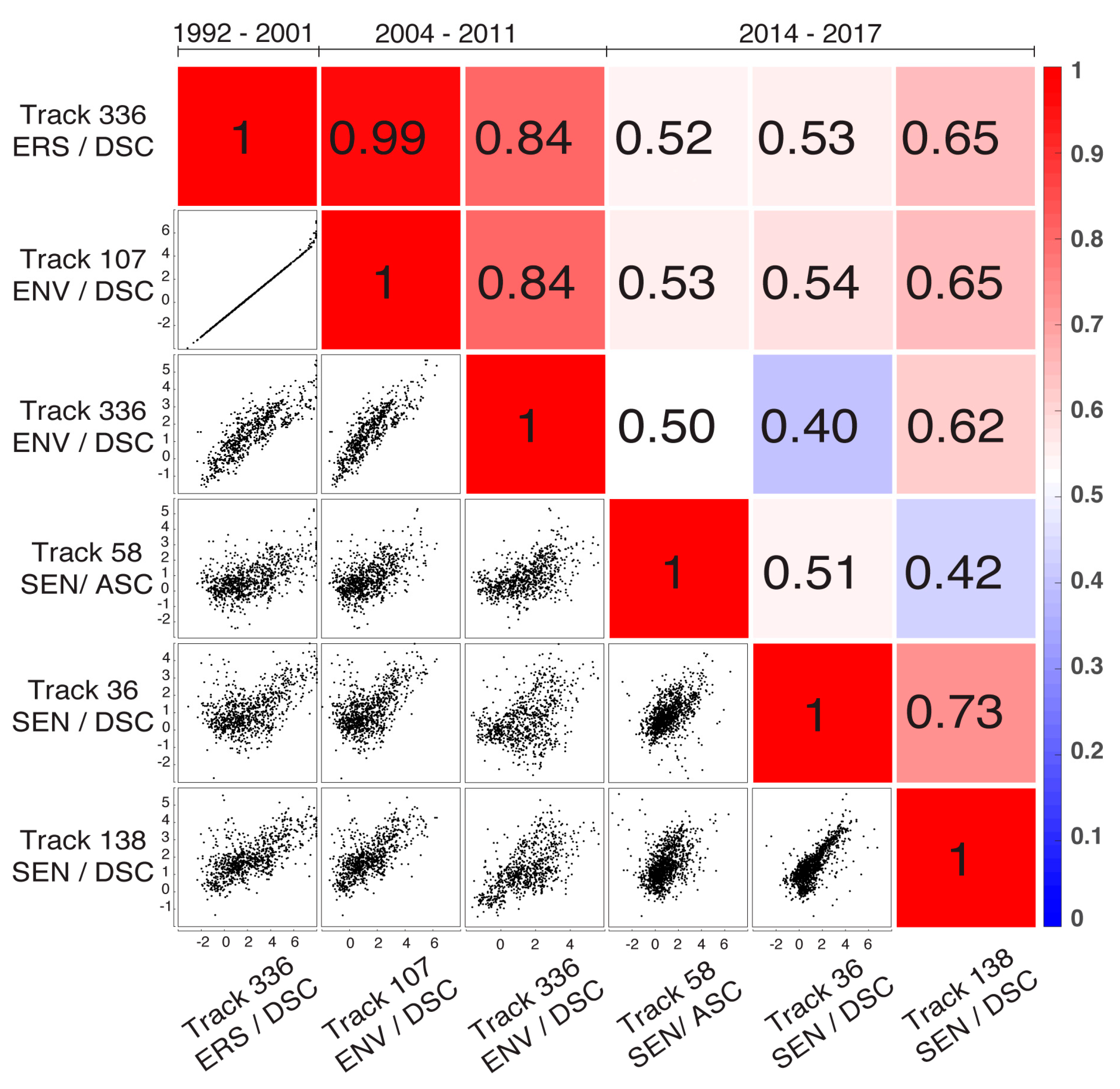
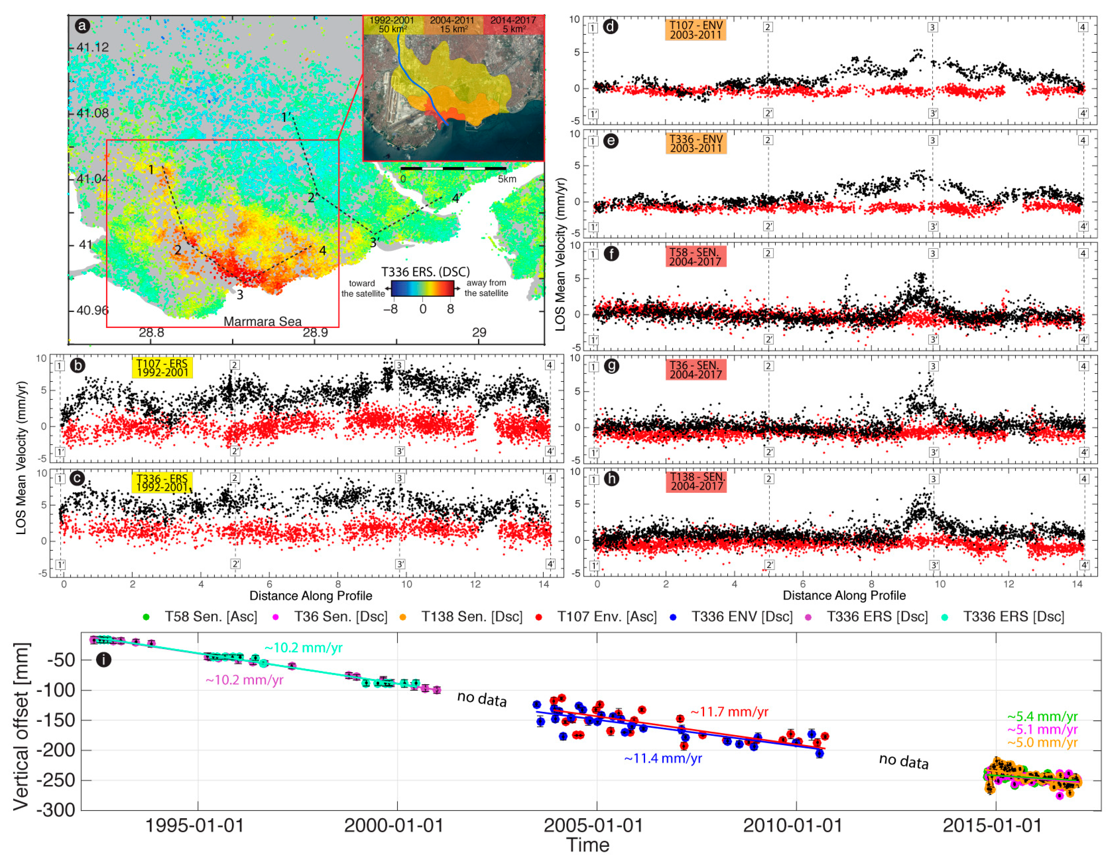
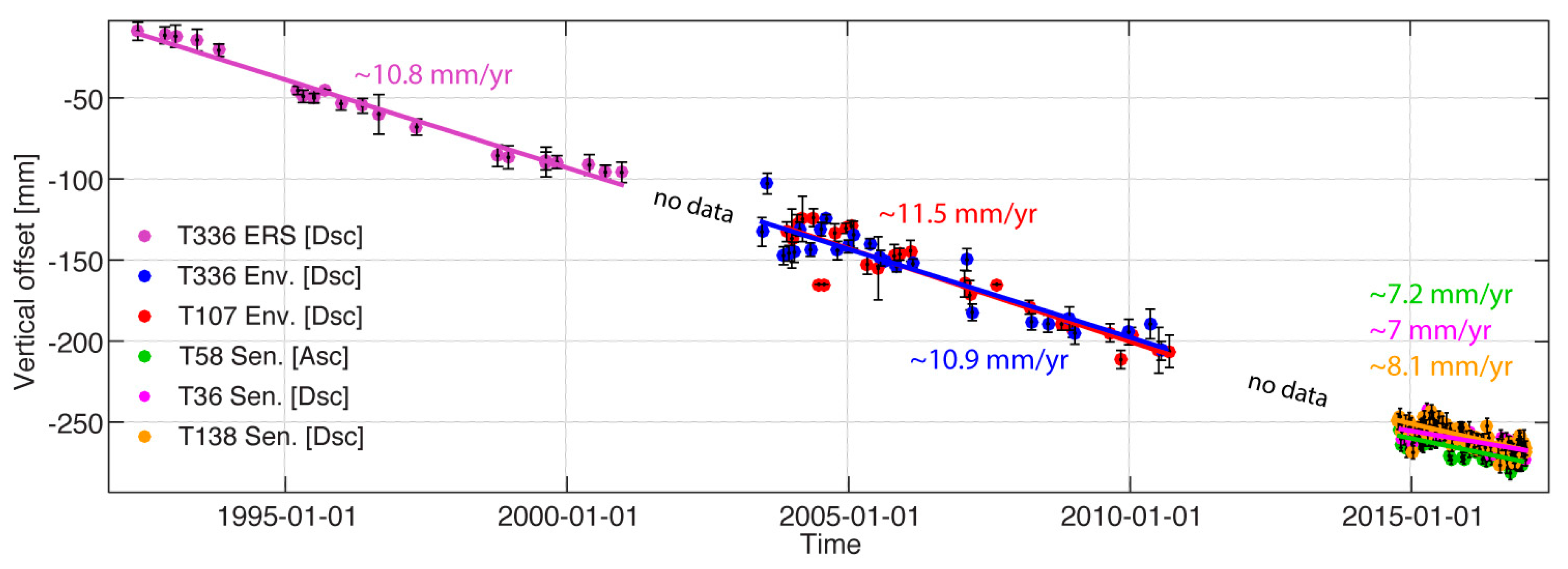
5.1. Self-Consistency between InSAR Measurements
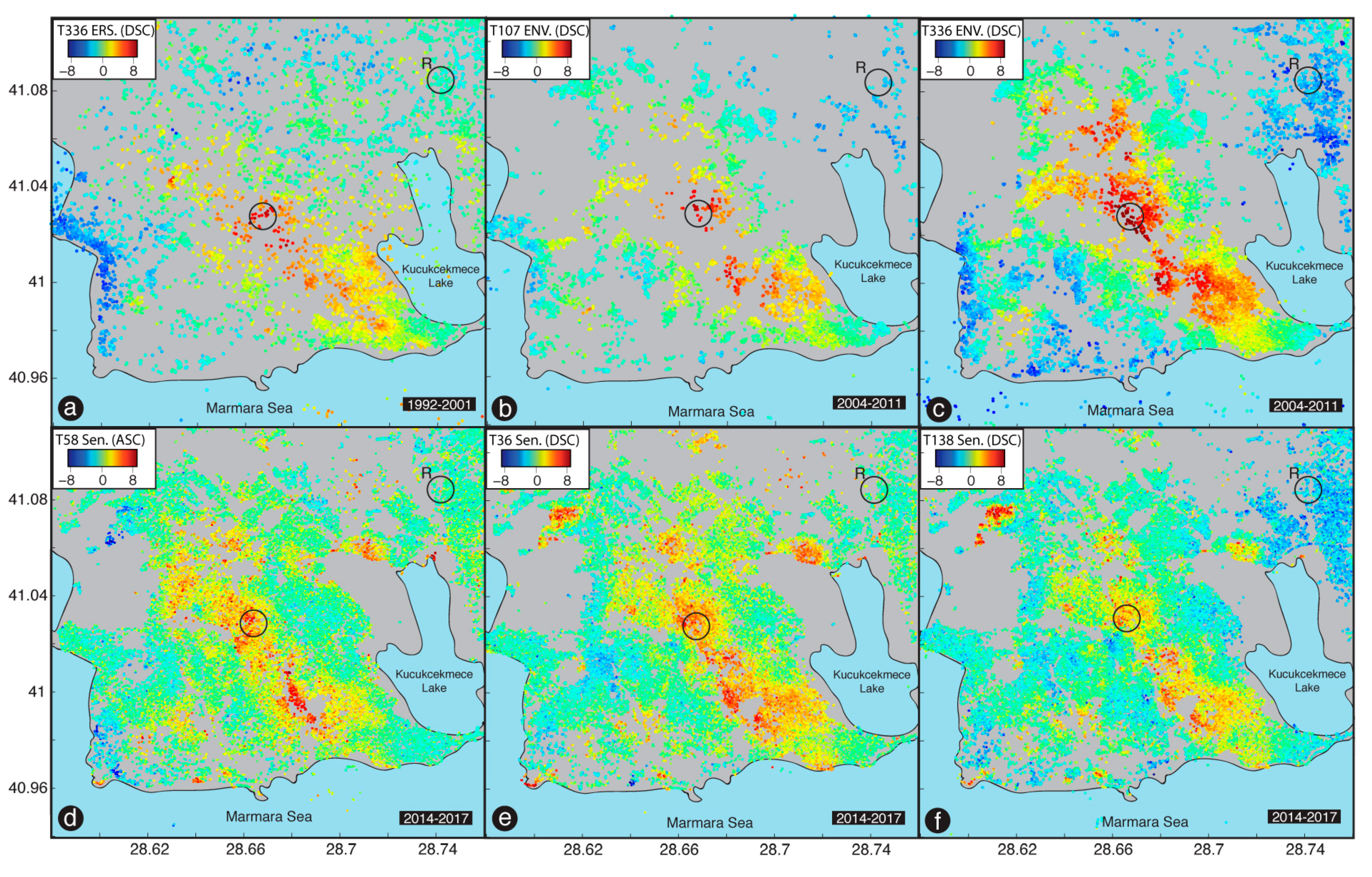
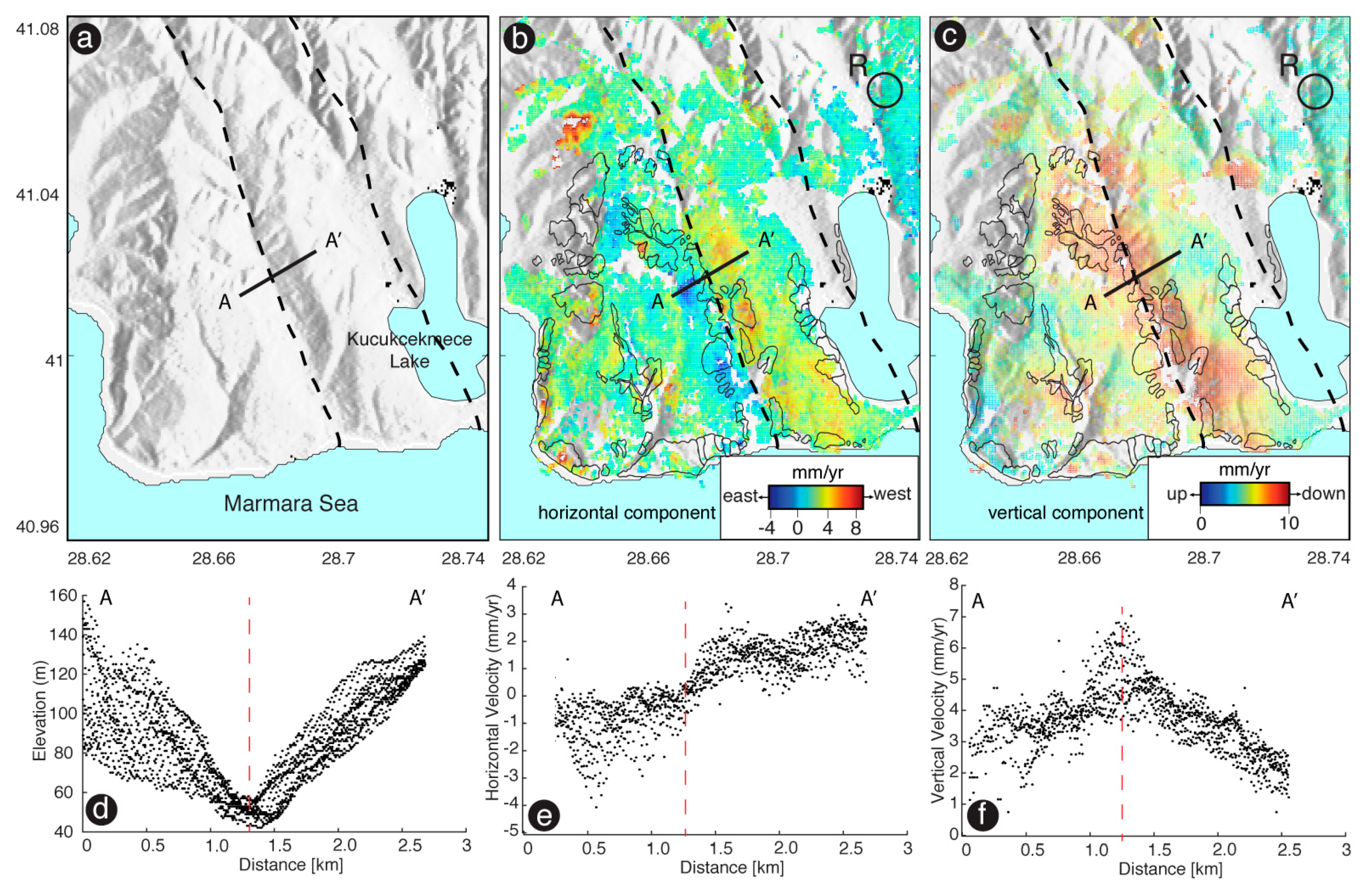
5.2. Site 1: Haramidere Valley
5.3. Site 2: Ayamama River
5.4. Sites 4, 6, and 3
5.5. Site 5
6. Conclusions
Acknowledgments
Author Contributions
Conflicts of Interest
References
- Van Leeuwen, K.; Sjerps, R. Istanbul: The challenges of integrated water resources management in Europe’s megacity. Environ. Dev. Sustain. 2016, 18, 1–17. [Google Scholar] [CrossRef]
- European Bank for Reconstruction and Development. Available online: http://www.ebrd.com/english/pa-ges/project/eia/42163nts.pdf (accessed on 15 October 2017).
- Helgert, T.; Heidbach, O. Slip-rate variability and distributed deformation in the Marmara Sea fault system. Nat. Geosci. 2010, 3, 132–136. [Google Scholar] [CrossRef]
- Massonnet, D.; Feigl, K.; Rossi, M.; Adrangna, F. Radar Interferometric mapping of deformation in the year after The Landers Earthquake. Nature 1994, 369, 227–230. [Google Scholar] [CrossRef]
- Zebker, H.A.; Rosen, P.A.; Goldstein, R.M.; Gabriel, A.; Werner, C.L. On the derivation of coseismic displacement fields using differential radar interferometry: The Landers earthquake. J. Geophys. Res. Solid Earth 1994, 99, 19617–19634. [Google Scholar] [CrossRef]
- Çakir, Z.; Chabalier, J.-B.; Armijo, R.; Meyer, B.; Barka, A.; Peltzer, G. Coseismic and early postseismic slip associated with the 1999 Izmit earthquake (Turkey), from SAR interferometry and tectonic field observations. Geophys. J. Int. 2003, 155, 93–110. [Google Scholar] [CrossRef]
- Diao, F.; Walter, T.; Solaro, G.; Wang, R.; Bonano, M.; Manzo, M.; Ergintav, S.; Zheng, Y.; Xiong, X.; Lanari, R. Fault locking near Istanbul: Indication of earthquake potential from InSAR and GPS observations. Geophys. J. Int. 2006, 205, 490–498. [Google Scholar] [CrossRef]
- Biggs, J.; Robertson, E.; Cashman, K. The lateral extent of volcanic interactions during unrest and eruption. Nat. Geosci. 2016, 9, 308–311. [Google Scholar] [CrossRef]
- Tomás, R.; Herrera, G.; Cooksley, G.; Mulas, J. Persistent scatterer interferometry subsidence data exploitation using spatial tools: The vega media of the Segura river basin case study. J. Hydrol. 2011, 400, 411–428. [Google Scholar] [CrossRef]
- Ruiz-Constán, A.; Ruiz-Armenteros, A.M.; Lamas-Fernández, F.; Martos-Rosillo, S.; Delgado, J.M.; Bekaert, D.P.S.; Sousa, J.J.; Gil, A.J.; Caro, C.M.; Hanssen, R.F.; et al. Multi-temporal InSAR evidence of ground subsidence induced by groundwater withdrawal: The Montellano aquifer (SW Spain). Environ. Earth Sci. 2016, 75, 1–16. [Google Scholar] [CrossRef]
- Kim, S.W.; Wdowinski, S.; Dixon, T.H.; Amelung, F.; Won, J.S.; Kim, J.W. InSAR-based mapping of the surface subsidence in Mokpo City, Korea, using JERS-1 and ENVISAT SAR data. Earth Planets Space 2008, 60, 453–461. [Google Scholar] [CrossRef]
- Kim, S.W.; Wdowinski, S.; Dixon, T.H.; Amelung, F.; Woo, J.; Won, J.S. Measurements and predictions of subsidence induced by soil consolidation using persistent scatterer InSAR and a hyperbolic model. Geophys. Res. Lett. 2010, 37, L05304. [Google Scholar] [CrossRef]
- Abdikan, S.; Arıkan, M.; Şanlı, F.B.; Çakir, Z. Monitoring of coal mining subsidence in peri-urban area of Zongundak city (NW Turkey) with persistent scatterer interferometry using ALOS-PALSAR. Environ. Earth Sci. 2014, 71, 4081–4089. [Google Scholar] [CrossRef]
- Hu, X.; Lu, Z.; Pierson, T.C.; Kramer, R.; George, D.L. Combining InSAR and GPS to determine transient movement and thickness of a seasonally active low-gradient translational landslide. Geophys. Res. Lett. 2008, 45, 1453–1462. [Google Scholar] [CrossRef]
- Colesanti, C.; Wasowski, J. Satellite SAR interferometry for wide-area slope hazard detection and site-specific monitoring of slow landslides. In Proceedings of the Ninth International Symposium on Landslides, Rio de Janeiro, Brazil, 28 June–2 July 2004. [Google Scholar]
- Liu, G.; Jia, H.; Nie, Y.; Li, T.; Zhang, R.; Yu, B.; Li, Z. Detecting subsidence in coastal areas by ultrashort-baseline TCPInSAR on the time series of high-resolution TerraSAR-X images. IEEE Trans. Geosci. Remote Sens. 2014, 52, 1911–1923. [Google Scholar] [CrossRef]
- Akarvardar, S.; Feigl, K.L.; Ergintav, S. Ground deformation in an area later damaged by an earthquake: Monitoring the Avcilar district of Istanbul, Turkey, by satellite radar interferometry. Geophys. J. Int. 2009, 178, 976–988. [Google Scholar] [CrossRef]
- Ferretti, A.; Colombo, D.; Fumagalli, A.; Novali, F.; Rucci, A. InSAR data for monitoring land subsidence: Time to think big. Proc. Int. Assoc. Hydrol. Sci. 2015, 372, 331–334. [Google Scholar] [CrossRef]
- Xu, B.; Feng, G.; Li, Z.; Wang, Q.; Wang, C.; Xie, R. Coastal subsidence monitoring associated with land reclamation using the point target based SBAS-INSAR method: A case study of Shenzhen, China. Remote Sens. 2016, 8, 652. [Google Scholar] [CrossRef]
- Intrieri, E.; Gigli, G.; Nocentini, M.; Lombardi, L.; Mugnai, F.; Fidolini, F.; Casagli, N. Sinkhole monitoring and early warning: An experimental and successful GB-InSAR application. Geomorphology 2015, 241, 304–314. [Google Scholar] [CrossRef]
- Luo, Q.; Perissin, D.; Zhang, Y.; Jia, Y. L- and X-band multi-temporal InSAR analysis of Tianjin subsidence. Remote Sens. 2014, 6, 7933–7951. [Google Scholar] [CrossRef]
- Zhang, K.; Ge, L.; Li, X.; Ng, A.-M. Monitoring ground surface deformation over the North China Plain using coherent ALOS PALSAR differential interferograms. J. Geod. 2013, 87, 253–265. [Google Scholar] [CrossRef]
- Chen, J.; Wu, J.; Zhang, L.; Zou, J.; Liu, G.; Zhang, R.; Yu, B. Deformation trend extraction based on multi-temporal InSAR in Shanghai. Remote Sens. 2013, 5, 1774–1786. [Google Scholar] [CrossRef]
- Osmanoglu, B.; Dixon, T.H.; Wdowinski, S.; Cabral-Cano, E.; Jiang, Y. Mexico city subsidence observed with persistent scatterer InSAR. Int. J. Appl. Earth Obs. Geoinf. 2011, 13, 1–12. [Google Scholar] [CrossRef]
- Khakim, M.Y.N.; Tsuji, T.; Matsuoka, T. Lithology-controlled subsidence and seasonal aquifer response in the Bandung basin, Indonesia, observed by synthetic aperture radar interferometry. Int. J. Appl. Earth Obs. Geoinf. 2014, 32, 199–207. [Google Scholar] [CrossRef]
- Ferretti, A.; Prati, C.; Rocca, F. Nonlinear subsidence rate estimation using permanent scatterers in differential SAR interferometry. IEEE Trans. Geosci. Remote Sens. 2000, 38, 2202–2212. [Google Scholar] [CrossRef]
- Ferretti, A.; Prati, C.; Rocca, F. Permanent scatterers in SAR interferometry. IEEE Trans. Geosci. Remote Sens. 2001, 39, 8–20. [Google Scholar] [CrossRef]
- Ferretti, A.; Novali, F.; Bürgmann, R.; Hilley, G.; Prati, C. InSAR permanent scatterer analysis reveals ups and downs in San Francisco Bay area. Eos Trans. Am. Geophys. Union 2004, 85, 317–324. [Google Scholar] [CrossRef]
- Colesanti, C.; Ferretti, A.; Novali, F.; Prati, C.; Rocca, F. SAR monitoring of progressive and seasonal ground deformation using the permanent scatterers technique. IEEE Trans. Geosci. Remote Sens. 2003, 41, 1685–1701. [Google Scholar] [CrossRef]
- Colesanti, C.; Ferretti, A.; Prati, C.; Rocca, F. Monitoring landslides and tectonic motions with the permanent scatterer technique. Eng. Geol. Spec. Issue Remote Sens. Monit. Landslides 2003, 68, 3–14. [Google Scholar] [CrossRef]
- Colesanti, C.; Ferretti, A.; Locatelli, R.; Novali, F.; Savio, G. Permanent scatterers: Precision assessment and multi-platform analysis. In Proceedings of the Geoscience and Remote Sensing Symposium, Tolouse, France, 21–25 July 2003. [Google Scholar]
- Calo, F.; Abdikan, S.; Gorum, T.; Pepe, A.; Kilic, H.; Sanli, F.B. The space-borne SBAS-DInSAR technique as a supporting tool for sustainable urban policies: The case of Istanbul Megacity, Turkey. Remote Sens. 2015, 7, 16519–16536. [Google Scholar] [CrossRef]
- Walter, T.R.; Manzo, M.; Manconi, A.; Solaro, G.; Lanari, R.; Motagh, M.; Woith, H.; Parolai, S.; Shirazei, M.; Zschau, J.; et al. Satellite monitoring of hazards: A focus on Istanbul, Turkey. Eos Trans. Am. Geophys. Union 2010, 91, 313–324. [Google Scholar] [CrossRef]
- Diao, F.; Walter, T.R.; Minati, F.; Wang, R.; Costantini, M.; Ergintav, S.; Xiong, X.; Prats-Iraola, P. Secondary Fault Activity of the North Anatolian Fault near Avcilar, Southwest of Istanbul: Evidence from SAR Interferometry Observations. Remote Sens. 2016, 8, 846. [Google Scholar] [CrossRef]
- Emre, Ö.; Duman, T.Y.; Özalp, S.; Elmaci, S.; Olgun, S.; Saroglu, F. Active Fault Map of Turkey with and Explanatory Text. In General Directorate of Mineral Research and Exploration; Special Publication Series-30; General Directorate of Mineral Research and Expansion (MTA): Ankara, Turkey, 2003. [Google Scholar]
- Okay, A.I.; Satır, M.; Tuysuz, O.; Akyuz, S.; Chen, F. The tectonics of the Strandja Massif: Late Variscan and mid-Mesozoic deformation and metamorphism in the north Aegean. Int. J. Earth Sci. 2001, 90, 217–233. [Google Scholar] [CrossRef]
- Ergintav, S.; Demirbag, E.; Ediger, V.; Saatcilar, R.; Inan, S.; Cankurtaranlar, A.; Dikbas, A.; Bas, M. Structural framework of onshore and offshore Avcilar, Istanbul under the influence of the North Anatolian Fault. Geophys. J. Int. 2001, 185, 93–105. [Google Scholar] [CrossRef]
- Duman, T.Y.; ve Arama Enstitüsü, M.T. İstanbul Metropolü Batısındaki (Küçükçekmece-Silivri-Çatalca Yöresi) Kentsel Gelişme Alanlarının Yerbilim Verileri; Özel Yayın Serisi 3; Maden Tetkik ve Arama Genel Müdürlügü (MTA): Ankara, Turkey, 2004.
- Özgül, N.; Üner, K.; Akmeşe, İ.; Bilgin, İ.; Kokuz, R.; Özcan, İ.; Tekin, M. İstanbul il Alanının Genel Jeoloji Özellikleri; İstanbul Büyükşehir Belediyesi Deprem ve Zemin İnceleme Müdürlüğü: Istanbul, Turkey, 2005; 79p. [Google Scholar]
- Tezcan, S.S.; Kaya, E.; Bal, E.; Ozdemir, Z. Seismic amplification at Avcilar, Istanbul. Eng. Struct. 2002, 24, 661–667. [Google Scholar] [CrossRef]
- Ozmen, B. Damage Investigation of 17 August 1999 Izmit Earthquake; Turkish Earthquake Foundation Press: Istanbul, Turkey, 2000; p. 140.
- Sen, S. A fault zone cause of large amplification and damage in Avcılar (west of Istanbul) during 1999 Izmit earthquake. Nat. Hazards 2007, 43, 351–363. [Google Scholar] [CrossRef]
- Meremonte, M.; Ozel, O.; Cranswick, E.; Erdik, M.; Safak, E.; Overturf, D.; Frankel, A.; Holzer, T. Damage and Site Response in Avcılar, West of Istanbul; Aykut, B., Ed.; The 1999 Izmit and Duzce Earthquake, Preliminary Results; Istanbul Technical University Press: Istanbul, Turkey, 2000; pp. 265–267. [Google Scholar]
- Cranswick, E.; Ozel, O.; Meremonte, M.; Erdik, M.; Safak, E.; Mueller, C.; Overturf, D.; Frankel, A. Earthquake damage, site response and building response in Avcılar, west of Istanbul, Turkey. J. Hous. Sci. Appl. 2000, 24, 85–96. [Google Scholar]
- Ozel, O.; Cranswick, E.; Meremonte, M.; Erdik, M.; Safak, E. Site effects in Avcilar, west of Istanbul, Turkey, from strong and weak motion data. Bull. Seismol. Soc. Am. 2002, 92, 499–508. [Google Scholar] [CrossRef]
- Ergin, M.; Özalaybey, S.; Aktar, M.; Yalcin, M.N. Site amplification at Avcılar, Istanbul. Tectonophysics 2004, 391, 335–346. [Google Scholar] [CrossRef]
- Eyidogan, H. Analysis of Micro-Seismicity of Istanbul Greater City Area and Active Faults. In Proceedings of the International Workshop on “Comparative Studies of the North Anatolian Fault (Northwest Turkey) and the San Andreas Fault (Southern California)”; ITU: Istanbul, Turkey, 2006; p. 54. [Google Scholar]
- Sen, S. Cekmece Golleri Arasındaki Bolgesinin Jeolojisi ve Sedimenter Ozellikleri. Unpublished MSc Thesis, İstanbul Üniversitesi Fen Bilimleri Enstitüsü, Istanbul, Turkey, 1994; 66p. [Google Scholar]
- Şen, Ş.; Koral, H.; Önalan, M. Sedimentary and tectonic evidence for the relationship between the Istranca Massif, the Paleozoic of Istanbul and overlying Tertiary sequence. In Proceedings of the International Symposium on the Petroleum Geology and Petroleum Potential of the Black Sea Area, Sile, Istanbul, Turkey, 22–24 September 1996; pp. 237–244. [Google Scholar]
- Kandilli Observatory Earth Research Institution (KOERI). The Earthquake Activities of the Marmara Region between 1990 and 2000; Bogazici Univ Kandilli Observatory and Earthquake Research Institute: Istanbul, Turkey, 2000. [Google Scholar]
- Dalgıç, S. Factors affecting the greater damage in the Avcılar area of Istanbul during the 17 August 1999 Izmit earthquake. Bull. Eng. Geol. Environ. 2004, 63, 221–232. [Google Scholar] [CrossRef]
- Duman, T.Y.; Can, T.; Gokceoglu, C.; Nefeslioglu, H.A. Landslide susceptibility mapping of Cekmece area (Istanbul, Turkey) by conditional probability. Hydrol. Earth Syst. Sci. Discuss. 2005, 2, 155–208. [Google Scholar] [CrossRef]
- Duman, T.Y.; Can, T.; Ulusay, R.; Keçer, M.; Emre, Ö.; Ateş, S.; Gedik, I. A geohazard reconnaissance study based on geoscientific information for development needs of the western region of Istanbul (Turkey). Environ. Geol. 2005, 4, 871–888. [Google Scholar] [CrossRef]
- Einfalt, T.; Keskin, F. Analysis of the Istanbul Flood 2009, BALWOIS 2010 Scientific Conference on Water Observation and Information System for Decision Support; Ministry of Environment and Physical Planning of Republic of Macedonia: Ohrid, Republic of Macedonia, 2010.
- Komuscu, A.I.; Celik, S. Analysis of the Marmara flood in Turkey, 7-1- September 2009: An assessment from hydrometerological perspective. Nat. Hazards 2013, 66, 781–808. [Google Scholar] [CrossRef]
- Ozcan, O.; Musaoglu, N. Vulnerability analysis of floods in urban areas using remote sensing and GIS. In Proceedings of the 30th EARSeL Symposium: Remote Sensing for Science, Education and Culture, Paris, France, 31 May–4 June 2010. [Google Scholar]
- Burak, S.; Kucukakca, E. Impact of Land Reclamation on the Coastal Areas in Istanbul. In Proceedings of the EGU General Assembly Conference, Vienna, Austria, 12–17 April 2015; Volume 17. [Google Scholar]
- TMMOB, Hurriyet Daily News. Available online: http://www.hurriyetdailynews.com/six-square-kilometers-of-istanbuls-land-reclaimed-from-the-sea-117884 (accessed on 28 November 2017).
- Rosen, P.A.; Hensley, S.; Joughin, I.R.; Li, F.K.; Madsen, S.N.; Rodriguez, E.; Goldstein, R.M. Synthetic aperture radar interferometry. Proc. IEEE 2000, 88, 333–382. [Google Scholar] [CrossRef]
- Kampes, B.; Stefania, U. Doris: The Delft Object-Oriented Radar Interferometric Software. In Proceedings of the 2nd International Symposium on Operationalization of Remote Sensing, Enschede, The Netherlands, 16–20 August 1999; p. 16. [Google Scholar]
- Sandwell, D.; Mellors, R.; Tong, X.; Wei, M.; Wessel, P. Open Radar Interferometry Software for Mapping Surface Deformation. Eos Trans. AGU 2011, 92, 234. [Google Scholar] [CrossRef]
- Hooper, A. A multi-temporal InSAR method incorporating both persistent scatterer and small baseline approaches. Geophys. Res. Lett. 2008, 35, L16302. [Google Scholar] [CrossRef]
- Hooper, A.; Bekaert, D.; Spaans, K.; Arıkan, M. Recent advances in SAR interferometry time series analysis for measuring crustal deformation. Tectonophysics 2012, 514–517, 1–13. [Google Scholar] [CrossRef]
- Ge, L.; Ng, A.H.; Li, X.; Abidin, H.Z.; Gumilar, I. Land subsidence characteristics of Bandung Basin as revealed by ENVISAT ASAR and ALOS PALSAR interferometry. Remote Sens. Environ. 2014, 154, 46–60. [Google Scholar] [CrossRef]
- Samieie-Esfahany, S.; Hanssen, R.; van Thienen-Visser, K.; Muntendam-Bos, A. On the effect of horizontal deformation on InSAR subsidence estimates. In Proceedings of the Fringe 2009 Workshop, Frascati, Italy, 30 November–4 December 2009; Volume 30. [Google Scholar]
- Dogan, U.; Oz, D.; Ergintav, S. Kinematics of landslide estimated by repeated GPS measurements in the Avcilar region of Istanbul, Turkey. Stud. Geophys. Geodyn. 2012, 57, 217–232. [Google Scholar] [CrossRef]
- Hu, X.; Oommen, T.; Lu, Z.; Wang, T.; Kim, J.W. Consolidation settlement of Salt Lake County tailings impoundment revealed by time-series InSAR observations from multiple radar satellites. Remote Sens. Environ. 2017, 199–209. [Google Scholar] [CrossRef]
- Kilic, H.; Ozener, P.T.; Yildirim, M.; Ozaydin, K.; Adatepe, S. Evaluation of Kucukcekmece region with respect to soil amplification. In Proceedings of the International Conference on Soil Mechanics and Geotechnical Engineering, Osaka, Japan, 12–16 September 2005. [Google Scholar]
- Plant, G.W.; Covil, C.S.; Hughes, R.A. Site Preparation for the New Hong Kong International Airport—Thomas Telford; Institution of Civil Engineers Publishing: London, UK, 1998. [Google Scholar]


| Track | C-Band/Satellite | Geometry | Time Interval | Incidence Angle at Swath Center | Interferograms Used | Density 2 (PS/km2) |
|---|---|---|---|---|---|---|
| T107 | ERS 1/2 | Descending | 1992–2001 | ~23 | 28 | 93 |
| T336 | ERS 1/2 | Descending | 1992–2001 | ~23 | 21 | 212 |
| T107 | ENVISAT | Descending | 2003–2011 | ~23 | 25 | 190 |
| T336 | ENVISAT | Descending | 2003–2011 | ~23 | 25 | 176.8 |
| T58 | SENTINEL 1 | Ascending | 2015–2017 | ~39.2 | 56 | 250.4 |
| T36 | SENTINEL 1 | Descending | 2014–2017 | ~33.7 | 65 | 289.6 |
| T138 | SENTINEL 1 | Descending | 2014–2017 | ~43.9 | 65 | 252.7 |
© 2018 by the authors. Licensee MDPI, Basel, Switzerland. This article is an open access article distributed under the terms and conditions of the Creative Commons Attribution (CC BY) license (http://creativecommons.org/licenses/by/4.0/).
Share and Cite
Aslan, G.; Cakır, Z.; Ergintav, S.; Lasserre, C.; Renard, F. Analysis of Secular Ground Motions in Istanbul from a Long-Term InSAR Time-Series (1992–2017). Remote Sens. 2018, 10, 408. https://doi.org/10.3390/rs10030408
Aslan G, Cakır Z, Ergintav S, Lasserre C, Renard F. Analysis of Secular Ground Motions in Istanbul from a Long-Term InSAR Time-Series (1992–2017). Remote Sensing. 2018; 10(3):408. https://doi.org/10.3390/rs10030408
Chicago/Turabian StyleAslan, Gokhan, Ziyadin Cakır, Semih Ergintav, Cécile Lasserre, and François Renard. 2018. "Analysis of Secular Ground Motions in Istanbul from a Long-Term InSAR Time-Series (1992–2017)" Remote Sensing 10, no. 3: 408. https://doi.org/10.3390/rs10030408
APA StyleAslan, G., Cakır, Z., Ergintav, S., Lasserre, C., & Renard, F. (2018). Analysis of Secular Ground Motions in Istanbul from a Long-Term InSAR Time-Series (1992–2017). Remote Sensing, 10(3), 408. https://doi.org/10.3390/rs10030408