Comparison of Pre-Event VHR Optical Data and Post-Event PolSAR Data to Investigate Damage Caused by the 2011 Japan Tsunami in Built-Up Areas


Abstract
1. Introduction
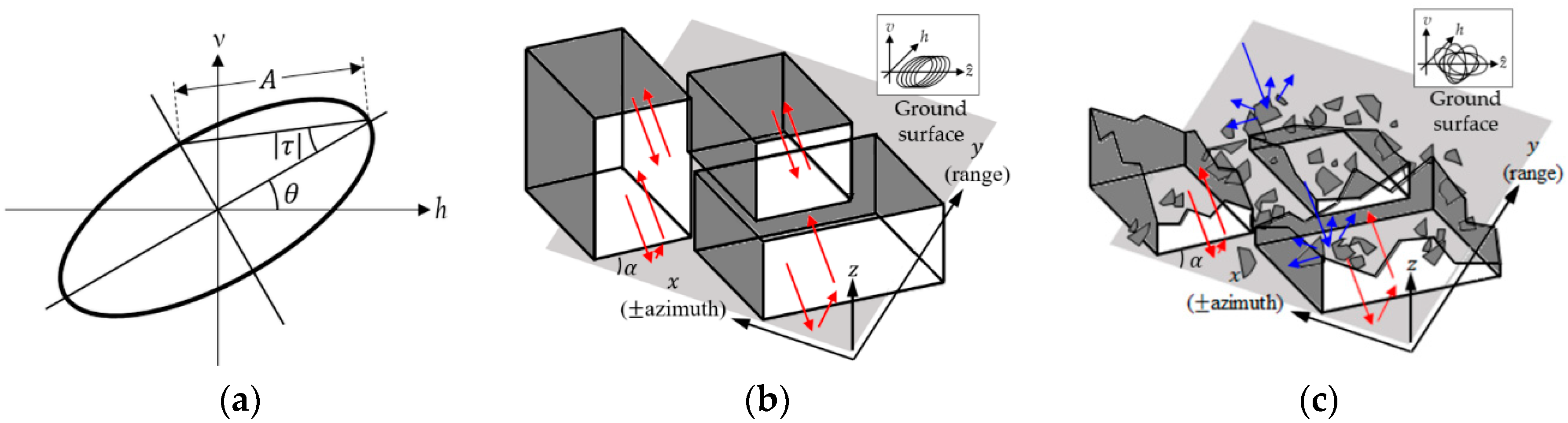
2. POA in Built-Up Areas
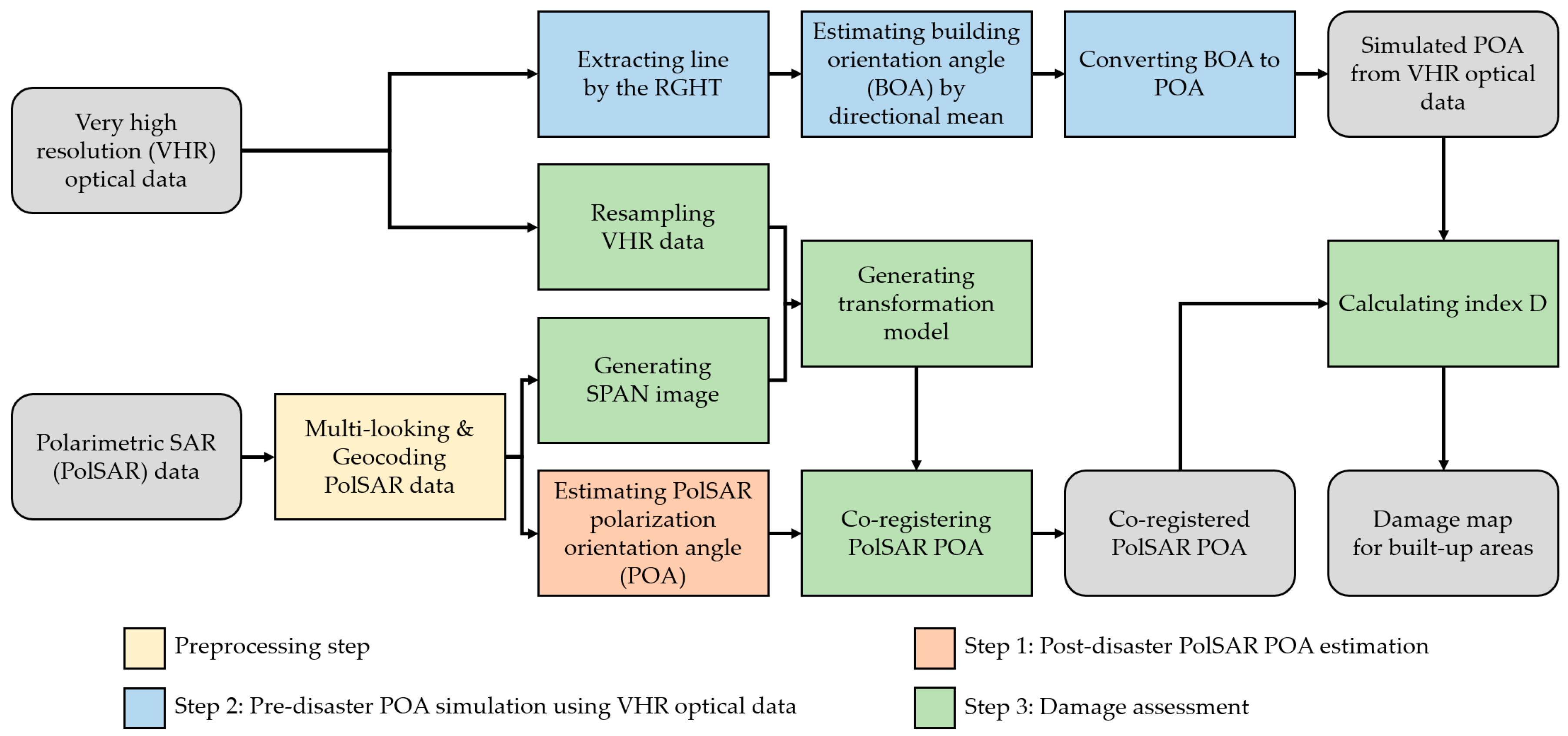
3. The Proposed Method
3.1. Step 1: Post-Disaster PolSAR POA Estimation
3.2. Step 2: Pre-Disaster POA Simulation Using VHR Optical Data
3.2.1. Line Extraction Using the RGHT
3.2.2. BOA Estimation Using Directional Mean
3.2.3. Converting BOA to POA
3.3. Step 3: Damage Assessment
3.3.1. Image Registration
3.3.2. Index for the Damage Assessment
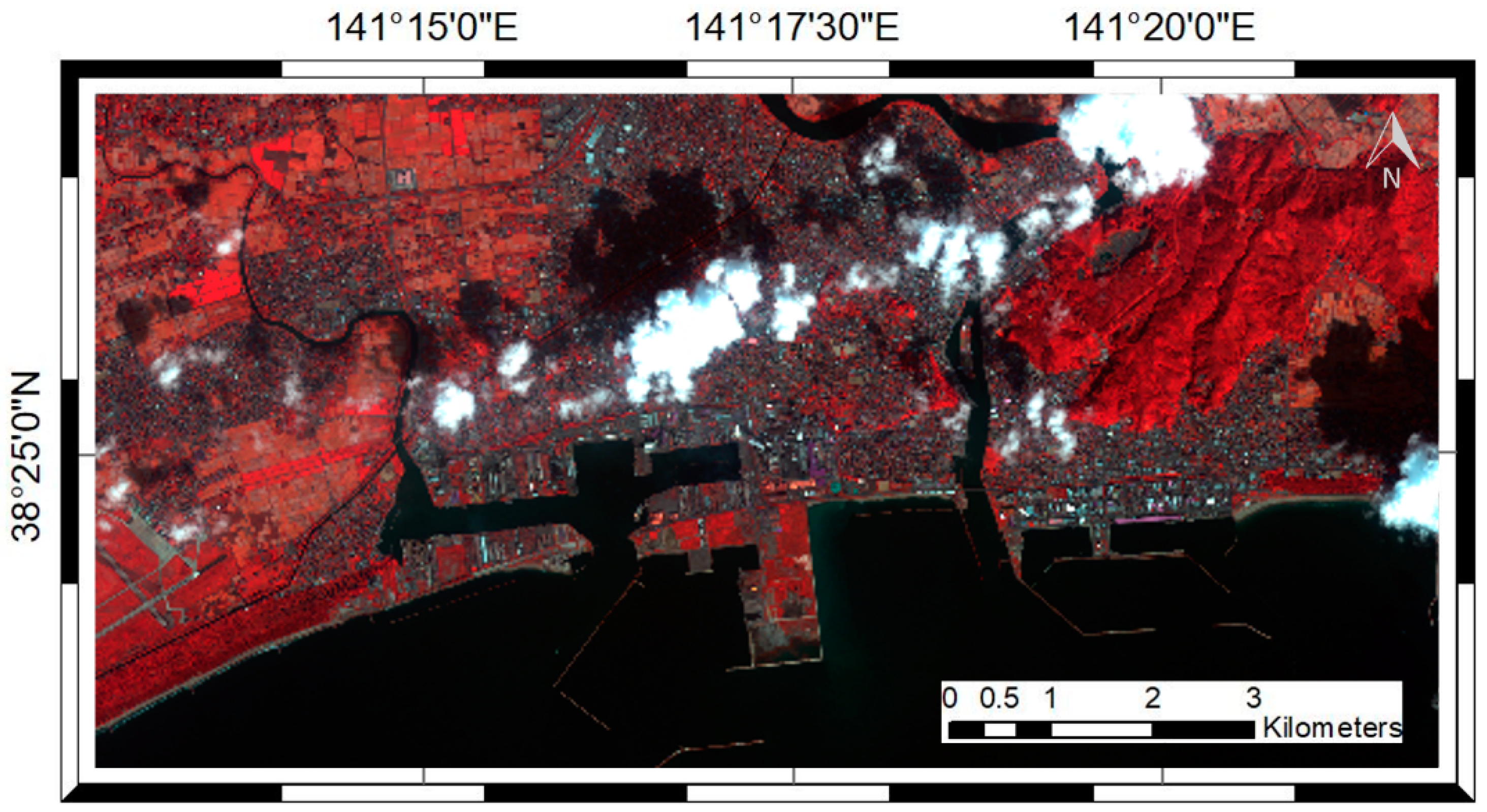
4. Study Site and Data Description
5. Experimental Results and Discussion
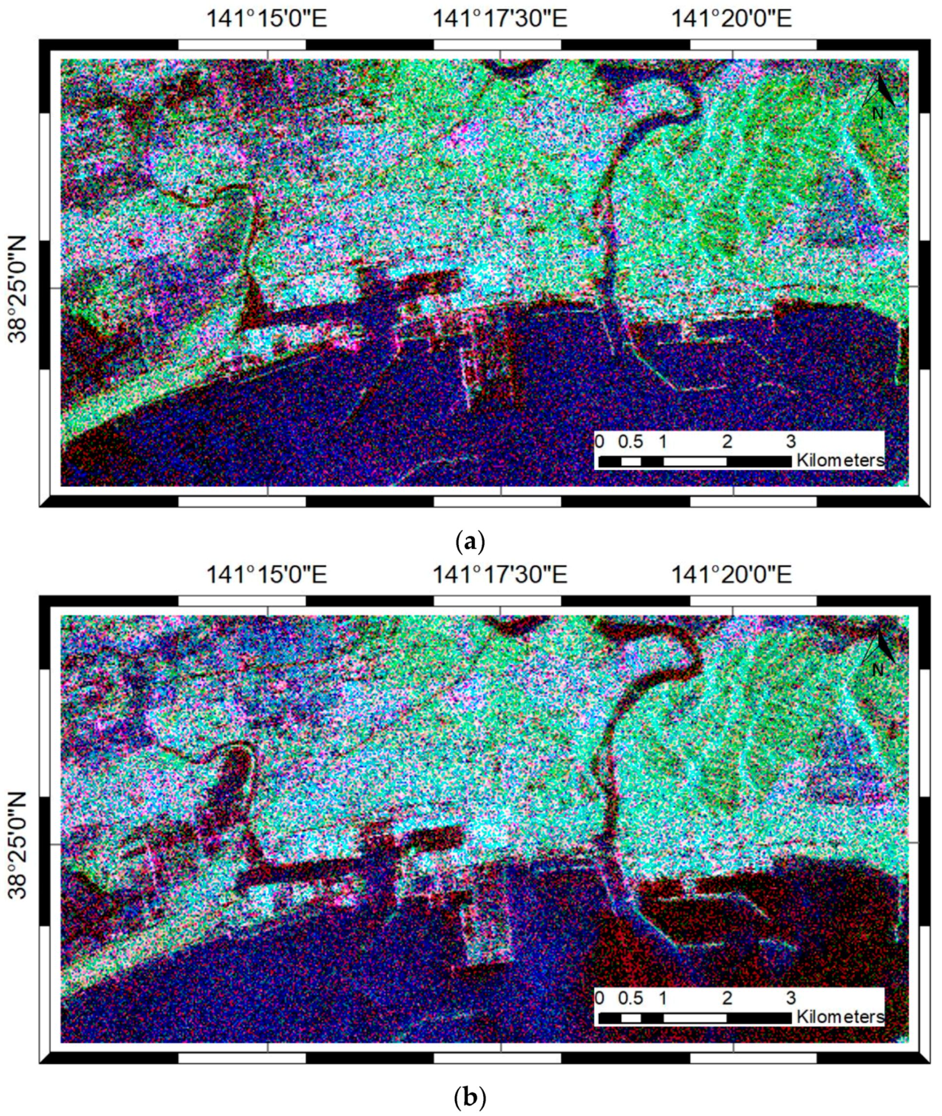
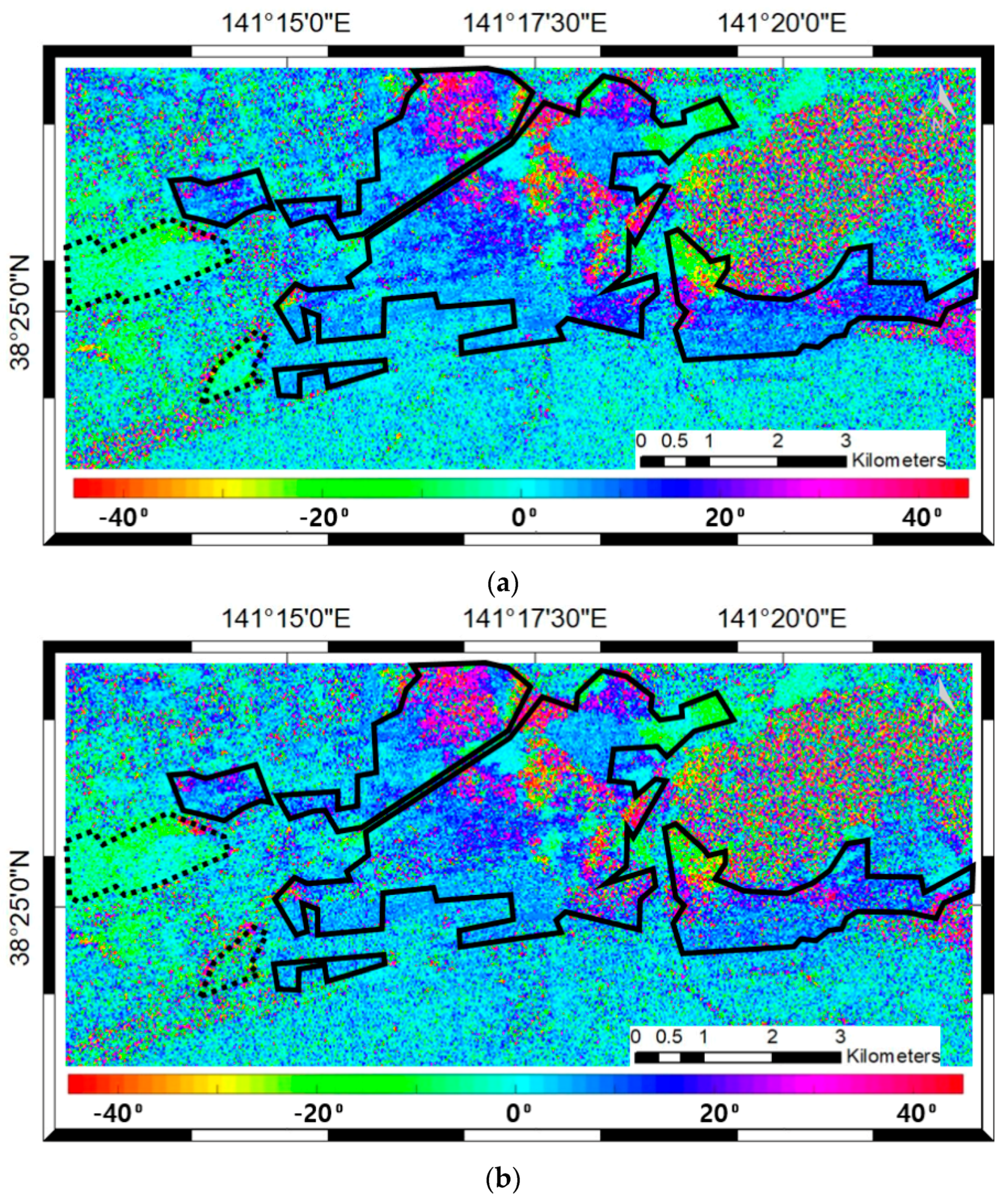
5.1. POAs from ALOS/PALSAR-1 and KOMPSAT-2 Data
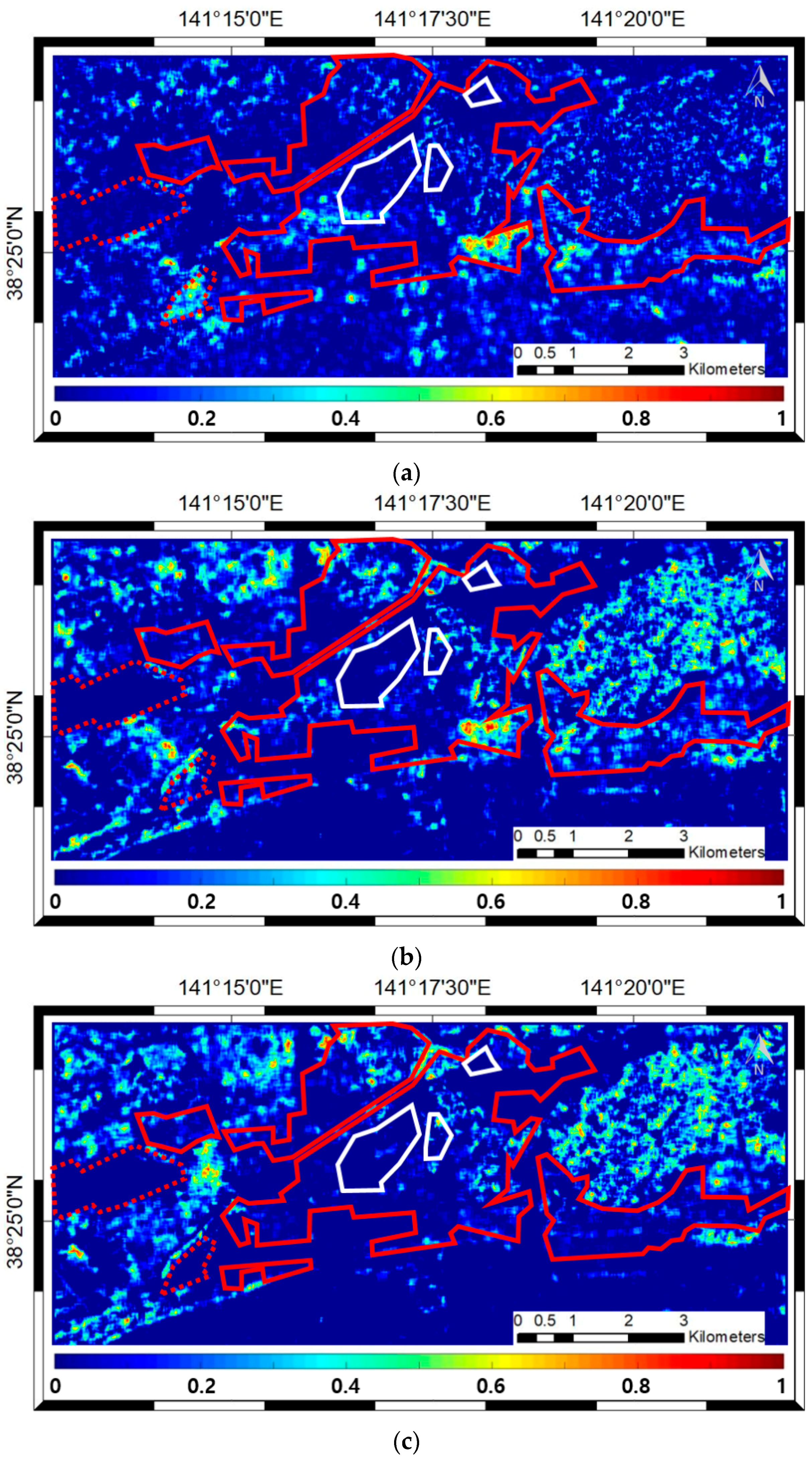
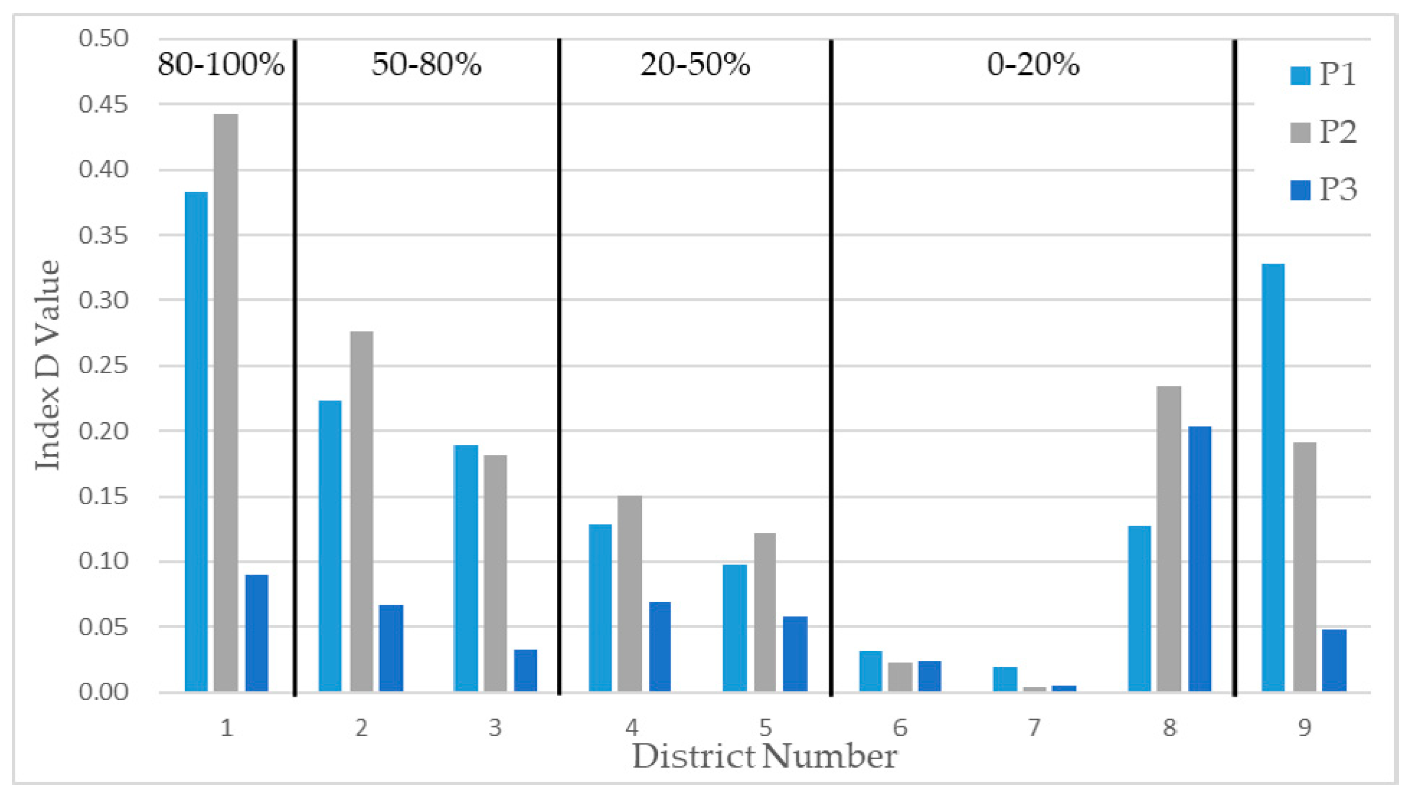
5.2. Tsunami-Induced Damage Investigation
5.3. Limitations of the Proposed Approach
6. Conclusions
Author Contributions
Funding
Conflicts of Interest
References
- Yonezawa, C.; Takeuchi, S. Decorrelation of SAR data by urban damages caused by the 1995 Hyogoken-nanbu earthquake. Int. J. Remote Sens. 2001, 22, 1585–1600. [Google Scholar] [CrossRef]
- Arciniegas, G.A.; Bijker, W.; Kerle, N.; Tolpekin, V.A. Coherence-and amplitude-based analysis of seismogenic damage in Bam, Iran, using ENVISAT ASAR data. IEEE Trans. Geosci. Remote Sens. 2007, 45, 1571–1581. [Google Scholar] [CrossRef]
- Chini, M.; Pierdicca, N.; Emery, W.J. Exploiting SAR and VHR optical images to quantify damage caused by the 2003 Bam earthquake. IEEE Trans. Geosci. Remote Sens. 2009, 47, 145–152. [Google Scholar] [CrossRef]
- Jin, Y.Q.; Wang, D. Automatic detection of terrain surface changes after Wenchuan earthquake, May 2008, from ALOS SAR images using 2EM-MRF method. IEEE Geosci. Remote Sens. Lett. 2009, 6, 344–348. [Google Scholar] [CrossRef]
- Chen, S.-W.; Sato, M. Tsunami damage investigation of built-up areas using multitemporal spaceborne full polarimetric SAR images. IEEE Trans. Geosci. Remote Sens. 2013, 50, 1985–1997. [Google Scholar] [CrossRef]
- Park, S.-E.; Yamaguchi, Y.; Kim, D. Polarimetric SAR remote sensing of the 2011 Tohoku earthquake using ALOS/PALSAR. Remote Sens. Environ. 2013, 132, 212–220. [Google Scholar] [CrossRef]
- Brunner, D.; Lemoine, G.; Bruzzone, L. Earthquake damage assessment of buildings using VHR optical and SAR imagery. IEEE Trans. Geosci. Remote Sens. 2015, 48, 2403–2420. [Google Scholar] [CrossRef]
- Hill, M.J.; Ticehurst, C.J.; Lee, J.S.; Grunes, M.R.; Donald, G.E.; Henry, D. Integration of optical and radar classifications for mapping pasture type in Western Australia. IEEE Trans. Geosci. Remote Sens. 2005, 43, 1665–1681. [Google Scholar] [CrossRef]
- Amarsaikhan, D.; Blotevogel, H.H.; Van Genderen, J.L.; Ganzorig, M.; Gantuya, R.; Nergui, B. Fusing high-resolution SAR and optical imagery for improved urban land cover study and classification. Int. J. Image Data Fusion 2010, 1, 83–97. [Google Scholar] [CrossRef]
- Laurin, G.V.; Liesenberg, V.; Chen, Q.; Guerriero, L.; Frate, F.D.; Bartolini, A.; Coomes, D.; Wilebore, B.; Lidsell, J.; Valentini, R. Optical and SAR sensor synergies for forest and land cover mapping in a tropical site in West Africa. Int. J. Appl. Earth Obs. Geoinf. 2013, 21, 7–16. [Google Scholar] [CrossRef]
- Kasapoğlu, N.G.; Eltoft, T. Decision fusion of classifiers for multifrequency PolSAR and optical data classification. In Proceedings of the 2013 6th International Conference on Recent Advances in Space Technologies (RAST), Istanbul, Turkey, 12–14 June 2013; pp. 411–416. [Google Scholar] [CrossRef]
- Wang, T.-L.; Jin, Y.-Q. Postearthquake building damage assessment using multi-mutual information from pre-event optical image and postevent SAR image. IEEE Geosci. Remote Sens. Lett. 2012, 9, 452–456. [Google Scholar] [CrossRef]
- Hajnsek, I.; Jagdhuber, T.; Schon, H.; Papathanassiou, K.P. Potential of estimating soil moisture under vegetation cover by means of PolSAR. IEEE Trans. Geosci. Remote Sens. 2009, 47, 442–454. [Google Scholar] [CrossRef]
- Qi, Z.; Yeh, A.G.O.; Li, X.; Lin, Z. A novel algorithm for land use and land cover classification using RADARSAT-2 polarimetric SAR data. Remote Sens. Environ. 2012, 118, 21–39. [Google Scholar] [CrossRef]
- Kajimoto, M.; Susaki, J. Urban-area extraction from polarimetric SAR images using polarization orientation angle. IEEE Geosci. Remote Sens. Lett. 2013, 10, 337–341. [Google Scholar] [CrossRef]
- Plank, S.; Twele, A.; Martinis, S. Landslide mapping in vegetated areas using change detection based on optical and polarimetric SAR data. Remote Sens. 2016, 8, 307. [Google Scholar] [CrossRef]
- Cloude, S.R.; Pottier, E. An entropy based classification scheme for land applications of polarimetric SAR. IEEE Trans. Geosci. Remote Sens. 1997, 35, 68–78. [Google Scholar] [CrossRef]
- Freeman, A.; Durden, S.L. A three-component scattering model for polarimetric SAR data. IEEE Trans. Geosci. Remote Sens. 1998, 36, 963–973. [Google Scholar] [CrossRef]
- Yamaguchi, Y.; Moriyama, T.; Ishido, M.; Yamada, H. Four-component scattering model for polarimetric SAR image decomposition. IEEE Trans. Geosci. Remote Sens. 2005, 43, 1699–1706. [Google Scholar] [CrossRef]
- Kimura, H.; Papathanassiou, K.P.; Hajnsek, I. Polarization orientation effects in urban areas on SAR data. In Proceedings of the 2005 IEEE International Geoscience and Remote Sensing Symposium, Seoul, Korea, 25–29 July 2005; pp. 4863–4867. [Google Scholar] [CrossRef]
- Iribe, K.; Sato, M. Analysis of polarization orientation angle shifts by artificial structures. IEEE Trans. Geosci. Remote Sens. 2007, 45, 3417–3425. [Google Scholar] [CrossRef]
- Kimura, H. Radar polarization orientation shifts in built-up areas. IEEE Geosci. Remote Sens. Lett. 2008, 5, 217–221. [Google Scholar] [CrossRef]
- Lee, J.S.; Pottier, E. Polarimetric Imaging: From Basics to Applications, 1st ed.; CRC Press: Boca Raton, FL, USA, 2009; ISBN 9781420054989. [Google Scholar]
- Lee, J.S.; Schuler, D.L.; Ainsworth, T.L. Polarimetric SAR data compensation for terrain azimuth slope variation. IEEE Trans. Geosci. Remote Sens. 2000, 38, 2153–2163. [Google Scholar] [CrossRef]
- Lee, J.S.; Schuler, D.L.; Ainsworth, T.L.; Krogager, E.; Kasilingam, D.; Boerner, W.-M. On the estimation of radar polarization orientation shifts induced by terrain slopes. IEEE Trans. Geosci. Remote Sens. 2002, 40, 30–41. [Google Scholar] [CrossRef]
- Guillaso, S.; Ferro-Famil, L.; Reigber, A.; Pottier, E. Building characterization using L-band polarimetric interferometric SAR data. IEEE Geosci. Remote Sens. Lett. 2005, 2, 347–351. [Google Scholar] [CrossRef]
- Yeom, J.-H.; Kim, Y.-I. A regular gird-based Hough transform for the extraction of urban features using high-resolution satellite images. Remote Sen. Lett. 2015, 6, 409–417. [Google Scholar] [CrossRef]
- Lee, J.S.; Grunes, M.R.; De Grandi, G. Polarimetric SAR speckle filtering and its implication for classification. IEEE Trans. Geosci. Remote Sens. 1999, 37, 2363–2373. [Google Scholar] [CrossRef]
- Schuler, D.L.; Lee, J.-S.; De Grandi, G. Measurement of topography using polarimetric SAR images. IEEE Trans. Geosci. Remote Sens. 1996, 34, 1266–1277. [Google Scholar] [CrossRef]
- Pottier, E.; Schuler, D.L.; Lee, J.S.; Ainsworth, T.L. Estimation of the terrain surface azimuthal/range slopes using polarimetric decomposition of POLSAR data. In Proceedings of the IEEE 1999 International Geoscience and Remote Sensing Symposium, Hamburg, Germany, 28 June–2 July 1999; pp. 2212–2214. [Google Scholar] [CrossRef]
- Schuler, D.L.; Lee, J.S.; Ainsworth, T.L. Compensation of terrain azimuthal slope effects in geophysical parameter studies using polarimetric SAR data. Remote Sens. Environ. 1999, 69, 139–155. [Google Scholar] [CrossRef]
- Chen, S.-W.; Ohki, M.; Shimada, M.; Sato, M. Deorientation effect investigation for model-based decomposition over orientated built-up areas. IEEE Geosci. Remote Sens. Lett. 2013, 10, 273–277. [Google Scholar] [CrossRef]
- Zhang, Y. Optimisation of building detection in satellite images by combining multispectral classification and texture filtering. ISPRS J. Photogramm. Remote Sens. 1999, 54, 50–60. [Google Scholar] [CrossRef]
- Huang, X.; Zhang, L. Morphological building/shadow index for building extraction from high-resolution imagery over urban areas. IEEE J. STARS 2012, 5, 161–172. [Google Scholar] [CrossRef]
- Cui, S.; Yan, Q.; Reinartz, P. Complex building description and extraction based on Hough transformation and cycle detection. Remote Sens. Lett. 2012, 3, 151–159. [Google Scholar] [CrossRef]
- Grigillo, D.; Fras, M.K.; Petrovič, D. Automated building extraction from IKONOS images in suburban areas. Int. J. Remote Sens. 2012, 33, 5149–5170. [Google Scholar] [CrossRef]
- Turker, M.; Koc-San, D. Building extraction from high-resolution optical spaceborne images using the integration of support vector machine (SVM) classification, Hough transformation and perceptual grouping. Int. J. Appl. Earth Obs. Geoinf. 2015, 34, 58–69. [Google Scholar] [CrossRef]
- Poullis, C.; You, S. Delineation and geometric modeling of road networks. ISPRS J. Photogramm. Remote Sens. 2010, 65, 165–181. [Google Scholar] [CrossRef]
- Zhang, Q.; Couloigner, I. Accurate centerline detection and line width estimation of thick lines using the radon transform. IEEE Trans. Image Process. 2007, 16, 310–316. [Google Scholar] [CrossRef] [PubMed]
- Hough, P.V.C. Method and Means for Recognizing Complex Patterns. US Patent 3,609,654, 25 March 1960. [Google Scholar]
- Illingworth, J.; Kittler, J. A survey of the Hough transform. Comput. Gr. Image Process. 1988, 44, 87–116. [Google Scholar] [CrossRef]
- Gall, J.; Yao, A.; Razavi, N.; Gool, L.V.; Lempitsky, V. Hough forests for object detection, tracking and action recognition. IEEE Trans. Pattern Anal. Mach. Intell. 2011, 33, 2188–2202. [Google Scholar] [CrossRef] [PubMed]
- Kiryati, N.; Eldar, Y.; Bruckstein, A.M. A probabilistic Hough transform. Pattern Recognit. 1991, 24, 303–316. [Google Scholar] [CrossRef]
- Leemans, V.; Destain, M.F. Line cluster detection using a variant of the Hough transform for culture row localization. Image Vis. Comput. 2006, 24, 541–550. [Google Scholar] [CrossRef]
- Guerreiro, R.F.C.; Aguiar, P.M.Q. Connectivity-enforcing Hough transform for the robust extraction of line segments. IEEE Trans. Image Process. 2012, 21, 4819–4829. [Google Scholar] [CrossRef] [PubMed]
- Canny, J. A computational approach to edge detection. IEEE Trans. Pattern Anal. Mach. Intell. 1987, PAMI-8, 679–698. [Google Scholar] [CrossRef]
- Gaile, G.L.; Burt, J.E. Directional Statistics; Geo Abstracts: Birmingham, UK, 1980; pp. 1–39. [Google Scholar]
- Fan, B.; Huo, C.; Pan, C.; Kong, Q. Registration of optical and SAR satellite images by exploring the spatial relationship of the improved SIFT. IEEE Geosci. Remote Sens. Lett. 2013, 10, 657–661. [Google Scholar] [CrossRef]
- Studholme, C.; Hill, D.L.; Hawkes, D.J. An overlap invariant entropy measure of 3D medical image alignment. Pattern Recognit. 1999, 32, 71–86. [Google Scholar] [CrossRef]
- Ye, Y.; Shan, J.; Bruzzone, L.; Shen, L. Robust registration of multimodal remote sensing images based on structural similarity. IEEE Trans. Geosci. Remote Sens. 2017, 55, 2941–2958. [Google Scholar] [CrossRef]
- National Police Agency. Available online: http://www.npa.go.jp/news/other/earthquake2011/pdf/higaijok yo_e.pdf (accessed on 30 April 2018).
- Japan Meteorological Agency. Available online: https://www.data.jma.go.jp/obd/stats/etrn/index.php (accessed on 6 November 2018).
- WorldMap—Ishinomaki Building Inundation. Available online: https://worldmap.harvard.edu/data/geo node:ishinomakimerge_063 (accessed on 30 April 2018).
- Zhang, F.; Xie, C.; Li, K.; Xu, M.; Wang, X.; Xia, Z. Forest and deforestation identification based on multitemporal polarimetric RADARSAT-2 images in Southwestern China. J. Appl. Remote Sens. 2012, 6, 063527. [Google Scholar] [CrossRef]


| Data Type | Sensor | Acquired Data | Incidence Angle 1 | Orbit Direction | Spatial Resolution |
|---|---|---|---|---|---|
| VHR optical data | KOMPSAT-2 | 1 October 2009 (Pre-event) | - | - | 1 m (Panchromatic) 4 m (Multi-spectral) |
| PolSAR | ALOS/PALSAR-1 | 2 April 2009 (Pre-event) | 23.780 | Ascending | 3.42 m (Azimuth) 23.23 m (Ground-range) |
| PolSAR | ALOS/PALSAR-1 | 8 April 2011 (Post-event) | 23.836 | Ascending | 3.43 m (Azimuth) 23.18 m (Ground-range) |
| Regions | Actual BOAaz1 | Estimated BOAaz 1 | Simulated POA | Pre-Tsunami PolSAR POA | ||
|---|---|---|---|---|---|---|
| - | - | |||||
| R1 | −40.538 | −36.040 | 35.533 | 0.689 | 32.516 | 0.277 |
| R2 | −39.772 | −35.096 | 33.764 | 0.792 | 35.704 | 0.400 |
| R3 | −37.615 | −31.093 | 29.536 | 0.729 | 24.139 | 0.574 |
| R4 | −22.559 | −20.417 | 18.748 | 0.711 | 21.235 | 0.665 |
| R5 | −19.128 | −16.808 | 15.775 | 0.903 | 17.339 | 0.927 |
| R6 | −13.752 | −14.708 | 14.100 | 0.902 | 14.180 | 0.938 |
| R7 | −10.681 | −10.623 | 10.028 | 0.920 | 10.038 | 0.951 |
| R8 | −7.956 | −9.971 | 9.952 | 0.976 | 8.146 | 0.914 |
| R9 | −6.738 | −8.339 | 7.925 | 0.882 | 5.843 | 0.931 |
| R10 | −3.583 | −4.469 | 4.107 | 0.912 | 6.116 | 0.959 |
| R11 | 2.934 | 2.073 | −2.031 | 0.864 | −1.330 | 0.988 |
| R12 | 15.318 | 12.955 | −12.246 | 0.861 | −9.449 | 0.895 |
| R13 | 16.426 | 13.371 | −12.148 | 0.745 | −13.615 | 0.935 |
| R14 | 19.408 | 16.927 | −15.438 | 0.924 | −10.773 | 0.809 |
| R15 | 44.436 | 41.924 | −41.496 | 0.670 | −37.037 | 0.458 |
| Districts | P1 | P2 | P3 | Damage Level (%) | Dominant POA 1 (°) | Density of Building |
|---|---|---|---|---|---|---|
| D1 | 0.383 | 0.443 | 0.090 | 80–100 | 14.988 | High |
| D2 | 0.223 | 0.276 | 0.067 | 50–80 | 7.802 | |
| D3 | 0.189 | 0.182 | 0.033 | 50–80 | 4.209 | |
| D4 | 0.129 | 0.151 | 0.069 | 20–50 | 11.015 | |
| D5 | 0.098 | 0.122 | 0.058 | 20–50 | 7.405 | |
| D6 | 0.032 | 0.023 | 0.024 | 0–20 | −7.839 | |
| D7 | 0.020 | 0.004 | 0.005 | 0–20 | 4.004 | |
| D8 | 0.127 | 0.234 | 0.204 | 0–20 | 29.747 | |
| D9 | 0.328 | 0.191 | 0.048 | 80–100 | −2.461 | Low |
© 2018 by the authors. Licensee MDPI, Basel, Switzerland. This article is an open access article distributed under the terms and conditions of the Creative Commons Attribution (CC BY) license (http://creativecommons.org/licenses/by/4.0/).
Share and Cite
Jung, M.; Yeom, J.; Kim, Y. Comparison of Pre-Event VHR Optical Data and Post-Event PolSAR Data to Investigate Damage Caused by the 2011 Japan Tsunami in Built-Up Areas. Remote Sens. 2018, 10, 1804. https://doi.org/10.3390/rs10111804
Jung M, Yeom J, Kim Y. Comparison of Pre-Event VHR Optical Data and Post-Event PolSAR Data to Investigate Damage Caused by the 2011 Japan Tsunami in Built-Up Areas. Remote Sensing. 2018; 10(11):1804. https://doi.org/10.3390/rs10111804
Chicago/Turabian StyleJung, Minyoung, Junho Yeom, and Yongil Kim. 2018. "Comparison of Pre-Event VHR Optical Data and Post-Event PolSAR Data to Investigate Damage Caused by the 2011 Japan Tsunami in Built-Up Areas" Remote Sensing 10, no. 11: 1804. https://doi.org/10.3390/rs10111804
APA StyleJung, M., Yeom, J., & Kim, Y. (2018). Comparison of Pre-Event VHR Optical Data and Post-Event PolSAR Data to Investigate Damage Caused by the 2011 Japan Tsunami in Built-Up Areas. Remote Sensing, 10(11), 1804. https://doi.org/10.3390/rs10111804