Desertification Information Extraction Based on Feature Space Combinations on the Mongolian Plateau
Abstract
:1. Introduction
2. Materials and Methods
2.1. Study Area
2.2. Data Sources and Preprocessing
2.3. Method
2.3.1. Principles of Feature Space
2.3.2. The Construction of Feature Space
2.3.3. Classification of Desertification
2.3.4. Accuracy Assessment and Comparison
3. Results
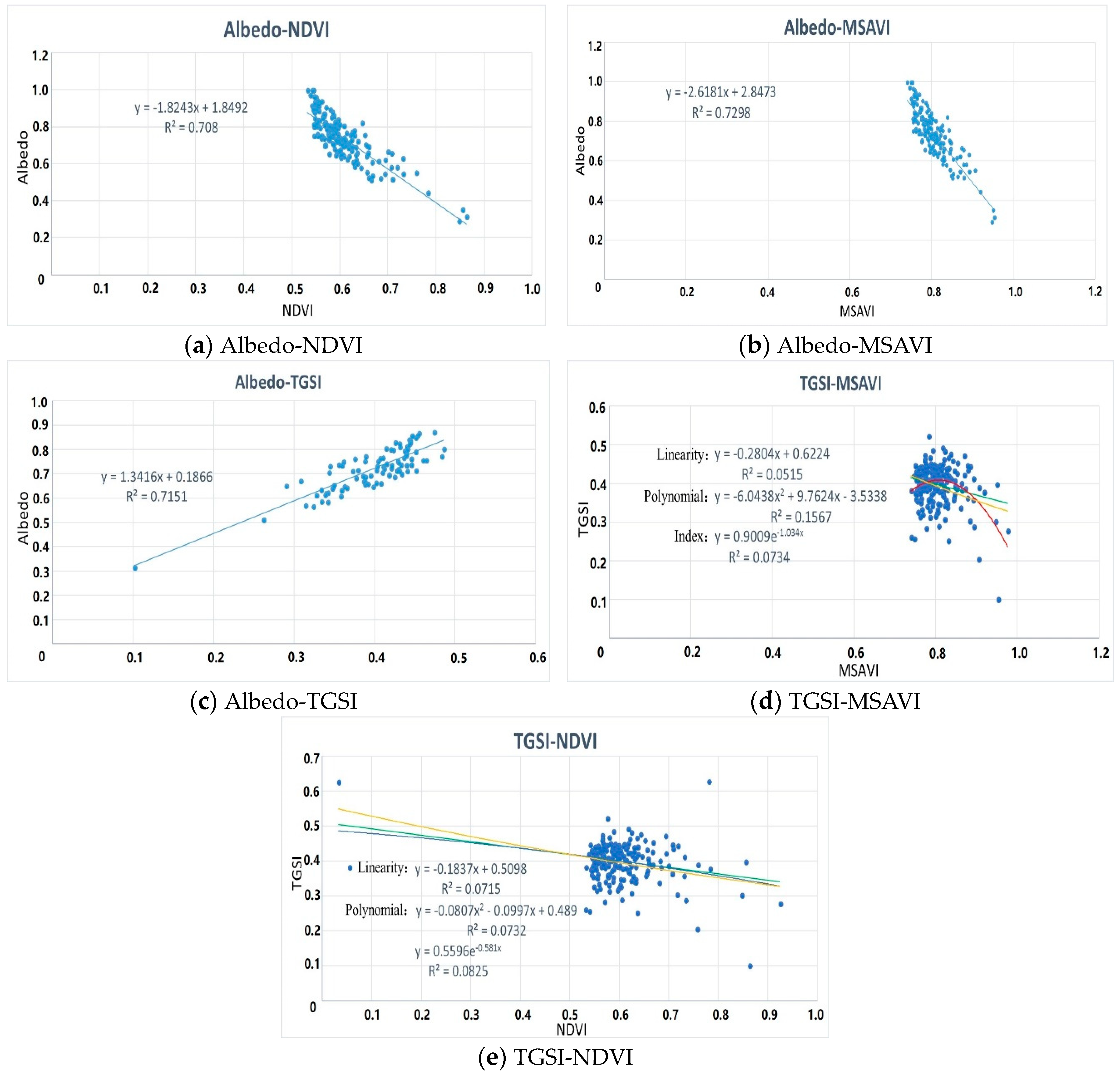
3.1. Quantitative Relationships among Feature Space Variables
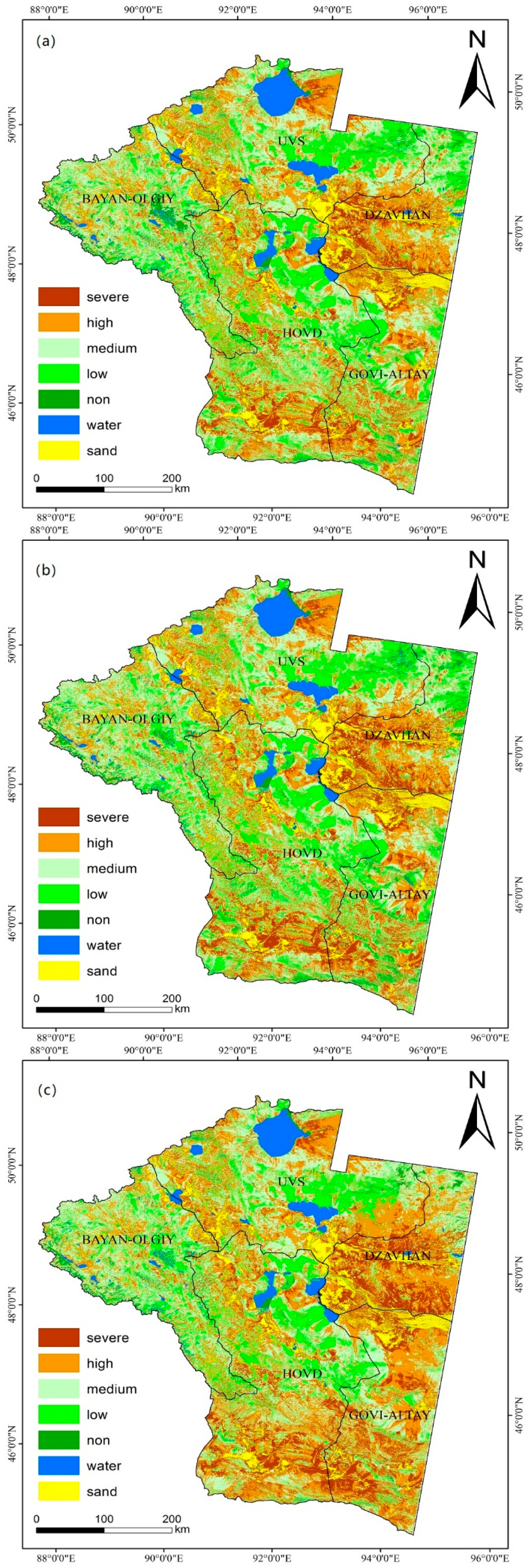
3.2. Results and Comparison
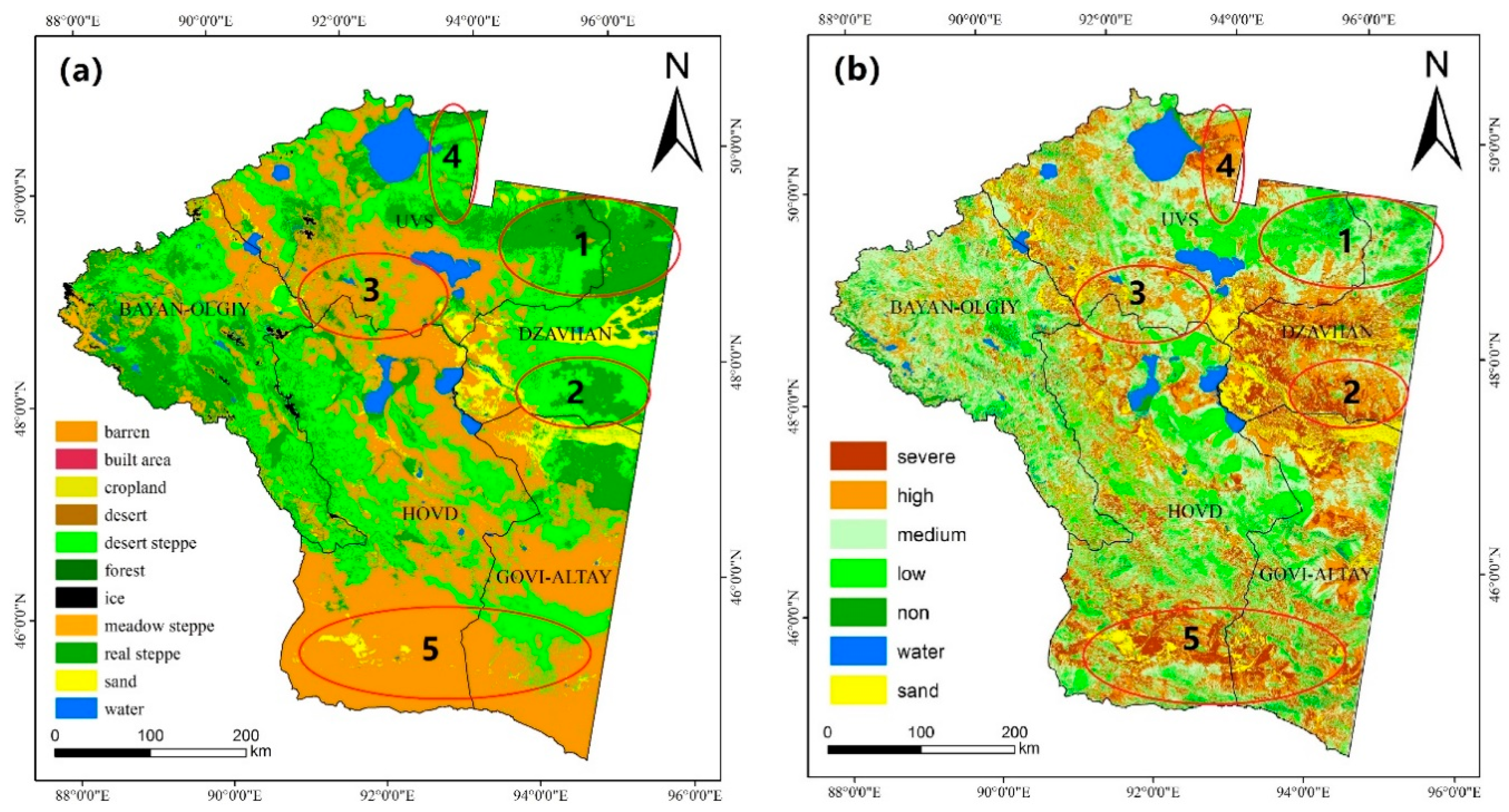
3.3. Accuracy Assessment
4. Discussion
5. Conclusions
Author Contributions
Funding
Acknowledgments
Conflicts of Interest
References
- Chang, S.; Wu, B.; Yan, N.; Davdai, B.; Nasanbat, E. Suitability assessment of satellite-derived drought indices for Mongolian grassland. J. Remote Sens. 2017, 9, 650. [Google Scholar] [CrossRef]
- Buren, G. Research on Current Status, Causes and Prospect of Desertification in Mongolia. Master’s Thesis, Inner Mongolia University, Inner Mongolia, China, 2011. [Google Scholar]
- Current Status of Desertification in Mongolia; Research Center on Desertification, Institute of Ecological Geography, Mongolian Academy of Sciences: Ulaanbaatar, Mongolia, 2007.
- Nearly 80% of Land in Mongolia Suffers from Desertification in Different Degrees. Available online: http://world.people.com.cn/n1/2017/0617/c1002-29345905.html (accessed on 11 December 2017).
- The Outline of the Plan for Building the Economic Corridor between China, Mongolia and Russia. Available online: http://www.ndrc.gov.cn/zcfb/zcfbghwb/201609/t20160912818326.html (accessed on 12 September 2018).
- Basso, F.; Bove, E.; Dumontet, S.; Ferrara, A.; Pisante, M.; Quaranta, G. Evaluating environmental sensitivity at the basin scale through the use of geographic information systems and remotely sensed data: An example covering the Agri basin (Southern Italy). J. Catena 2000, 40, 19–35. [Google Scholar] [CrossRef]
- Holm, A.M.; Cridland, S.W.; Roderick, M.L. The use of time-integrated NOAA NDVI data and rainfall to assess landscape degradation in the arid shrubland of Western Australia. J. Remote Sens. Environ. 2003, 85, 145–158. [Google Scholar] [CrossRef]
- Geerken, R.; Ilaiwi, M. Assessment of rangeland degradation and development of a strategy for rehabilitation. J. Remote Sens. Environ. 2004, 90, 490–504. [Google Scholar] [CrossRef]
- Wessels, K.J.; van den Bergh, F.; Scholes, R.J. Limits to detectability of land degradation by trend analysis of vegetation index data. J. Remote Sens. Environ. 2012, 125, 10–22. [Google Scholar] [CrossRef]
- Liang, S.L. Narrowband to broadband conversions of land surface albedo I algorithms. J. Remote Sens. Environ. 2001, 76, 213–238. [Google Scholar] [CrossRef]
- Robinove, C.J.; Chavez, P.S.; Gehring, D. Arid land monitoring using Landstat albedo difference images. J. Remote Sens. Environ. 1981, 11, 133–156. [Google Scholar] [CrossRef]
- Rasmussen, K.; Fog, B.; Madsen, J.E. Desertification in reverse? Observations from northern Burkina Faso. J. Glob. Environ. Chang. 2001, 11, 271–282. [Google Scholar] [CrossRef]
- Albalawi, E.K.; Kumar, L. Using remote sensing technology to detect, model and map desertification: A review. J. Food Agric. Environ. 2013, 11, 791–797. [Google Scholar]
- Guo, Q.; Fu, B.; Shi, P.; Cudahy, T.; Zhang, J.; Xu, H. Satellite monitoring the spatial-temporal dynamics of desertification in response to climate change and human activities across the Ordos Plateau, China. J. Remote Sens. 2017, 9, 525. [Google Scholar] [CrossRef]
- Zeng, Y.N.; Xiang, N.P.; Feng, Z.D.; Hu, H. Albedo-NDVI space and remote sensing synthesis index models for desertification monitoring. J. Sci. Geogr. Sin. 2006, 26, 75–81. [Google Scholar] [CrossRef]
- Qi, J.; Chehbouni, A.; Huete, A.R.; Kerr, Y.H.; Sorooshian, S. A modified soil adjusted vegetation index. J. Remote Sens Envrion. 2015, 48, 119–126. [Google Scholar] [CrossRef]
- Wu, X.T. Research and Application of Remote Sensing Monitoring Methods for Grassland Desertification. Master’s Thesis, Chinese Academy of Agricultural Sciences, Beijing, China, 2003. [Google Scholar]
- Feng, J.; Ding, J.L.; Wei, W.Y. Research on soil salinization in Weikui Oasis based on the characteristic space of Albedo-MSAVI. J. China Rural Water Hydropower 2018. [Google Scholar] [CrossRef]
- Vova, O.; Kappas, M.; Renchin, T.; Degener, J. Land degradation assessment in Gobi-Altai province. In Proceedings of the Trans-Disciplinary Research Conference: Building Resilience of Mongolian Rangelands, Ulaanbaatar, Mongolia, 9–10 June 2015. [Google Scholar]
- Zhu, Z.D.; Wang, T. An analysis on the trend of land dessertification in northern China duing the last decade based on examples from some typical areas. J. Acta Geogr. Sin. 1990. [Google Scholar] [CrossRef]
- Qing, S.; Gao, H.; Huang, C. Monitoring desertification processes in Mongolian Plateau using MODIS tasseled cap transformation and TGSI time series. J. Arid Land 2018, 10, 12–26. [Google Scholar] [CrossRef]
- Lamchin, M.; Lee, J.Y.; Lee, W.K.; Lee, E.J.; Kim, M.; Lim, C.H.; Choi, H.A.; Kim, S.R. Assessment of land cover change and desertification using remote sensing technology in a local region of Mongolia. J. Adv. Space Res. 2016, 57, 64–77. [Google Scholar] [CrossRef]
- Lamchin, M.; Lee, W.K.; Jeon, S.; Lamchin, M.; Lee, W.K.; Jeon, S.W.; Lee, J.Y.; Song, C.; Piao, D.; Lim, C.H.; et al. Correlation between Desertification and Environmental Variables Using Remote Sensing Techniques in Hogno Khaan, Mongolia. J. Sustain. 2017, 9, 581. [Google Scholar] [CrossRef]
- Population and Housing Census of Mongolia; National Statistical Office: Ulaanbaatar, Mongolia, 2010.
- Wang, J.L.; Cheng, K.; Zhu, J.X.; Liu, Q. Study and development of Mongolian land cover data products with 30 meters resolution and its pattern analysis. J. Geo-Inf. Sci. 2018, 20, 1263–1273. [Google Scholar] [CrossRef]
- Li, S.G.; Harazono, Y.; Oikawa, T.; Zhao, H.L.; He, Z.Y.; Chang, X.L. Grassland desertification by grazing and the resulting micrometeorological changes in inner Mongolia. J. Agric. For. Meteorol. 2000, 102, 125–137. [Google Scholar] [CrossRef]
- Wang, Y.; Yan, X. Climate change induced by Southern Hemisphere desertification. J. Phys. Chem. Earth 2017, 102, 40–47. [Google Scholar] [CrossRef]
- Ma, Z.; Xie, Y.; Jiao, J.; Wang, X. The Construction and Application of an Aledo-NDVI Based Desertification Monitoring Model. J. Procedia Environ. Sci. 2011, 10, 2029–2035. [Google Scholar] [CrossRef]
- Zhu, S.; Chen, Y. Methods for Atmospheric Radiation Correction. J. Geospat. Inf. 2010. [Google Scholar] [CrossRef]
- Zheng, W.; Zeng, Z.Y. A Review on Methods of Atmospheric Correction for Remote Sensing Images. J. Remote Sens. Inf. 2004, 4, 66–70. [Google Scholar] [CrossRef]
- Carlson, T.N.; Ripley, D.A. On the relation between NDVI, fractional vegetation cover, and leaf area index. J. Remote Sens. Environ. 1997, 62, 241–252. [Google Scholar] [CrossRef]
- Qi, J.; Chehouni, A.; Huete, A.R. A modified soil adjusted vegetation index. J. Remote Sens. Environ. 1994, 48, 119–126. [Google Scholar] [CrossRef]
- Xiao, J.; Shen, Y.; Tateishi, R.; Bayaer, W. Development of topsoil grain size index for monitoring desertification in arid land using remote sensing. Int. J. Remote Sens. 2006, 27, 2411–2422. [Google Scholar] [CrossRef]
- Liang, S.; Shuey, C.J.; Russ, A.L.; Fang, H.; Chen, M.; Walthall, C.L.; Daughtry, C.S.T.; Hunt, R., Jr. Narrowband to broadband conversions of land surface albedo: II. Validation. J. Remote Sens. Environ. 2003, 84, 25–41. [Google Scholar] [CrossRef]
- Michel, M. Verstraete and Bernard Pinty: Designing optimal spectral indexes for remote sensing applications. J. Remote Sens. Environ. 1996, 34, 1254–1265. [Google Scholar] [CrossRef]
- Zeng-Hai, W.U.; Tao, L.I. The comprehensive performance evaluation of the high-tech development zone: Analysis based on the natural breakpoint method. J. Stat. Inf. Forum 2013, 3, 82–88. [Google Scholar] [CrossRef]
- Bao, P.Y.; Zhang, Y.J.; Gong, L. Study on consistency of land surface albedo obtained from ETM+ and MODIS. J. Hohai Univ. 2007, 35, 67–71. [Google Scholar] [CrossRef]
- Fung, T.; Ledrew, E.F. The Determination of Optimal Threshold Levels for Change Detection Using Various Accuracy Indices. J. Photogramm. Eng. Remote Sens. 1988, 54, 1449–1454. [Google Scholar]
- Green, K. Assessing the Accuracy of Remotely Sensed Data: Principles and Practices, 2nd ed.; CRC Press/Taylor & Francis: Boca Raton, FL, USA, 2009. [Google Scholar]
- Lin, M.L.; Chu, C.M.; Shih, J.Y.; Wang, Q.B.; Chen, C.W.; Wang, S. Assessment and monitoring of desertification using satellite imagery of MODIS in East Asia. J. Proc. SPIE 2006, 6411. [Google Scholar] [CrossRef]
- Xu, D.; Li, C.; Song, X. The Research of the Quantitative Method of Desertification Assessment at Large Scale Based on MODIS Data and Decision Tree Model—A Case Study in Farming-Pastoral Region of North China. In Proceedings of the International Conference on Remote Sensing, Environment and Transportation Engineering, Nanjing, China, 1–3 June 2012; pp. 1–4. [Google Scholar] [CrossRef]
- Sa, R.; Yin, S.; Bao, Y.; Bao, H. Change of Desertification based on MODIS Data in the Mongolia Border Region. In Proceedings of the 7th Annual Meeting of Risk Analysis Council of China Association for Disaster Prevention, Changsha, China, 4–6 November 2016. [Google Scholar]
- Shuyong, M.A.; Zhu, X.; Yulun, A.N. Remote sensing image classification based on decision tree in the karst rocky desertification areas: A case study of Kaizuo Township. Asian Agric. Res. 2014, 21, 58–62. [Google Scholar]
- Zhou, G.; Zhang, R.; Shi, Y.; Su, C.; Liu, Y.; Yan, H. Extraction of exposed carbonatite in karst desertification area using co-location decision tree. In Proceedings of the 2014 IEEE Geoscience and Remote Sensing Symposium, Quebec City, QC, Canada, 13–18 July 2014; pp. 3514–3517. [Google Scholar] [CrossRef]
- Zhu, X.; An, Y.; Yue, M. Land use classification based on decision tree in karst rocky desertification areas. In Proceedings of the 2011 International Conference on Electric Technology and Civil Engineering (ICETCE), Lushan, China, 22–24 April 2011; pp. 5149–5153. [Google Scholar] [CrossRef]


| Feature Space Models | K |
|---|---|
| Albedo-NDVI | 0.55 |
| Albedo-MSAVI | 0.38 |
| Albedo-TGSI | −0.75 |
| Model | Level | DDI |
|---|---|---|
| Albedo-NDVI | severe desertification | <−0.23 |
| high desertification | −0.23 to −0.19 | |
| medium desertification | −0.19 to −0.15 | |
| low desertification | −0.15 to −0.05 | |
| non-desertification | >−0.05 | |
| Albedo-MSAVI | severe desertification | <−0.51 |
| high desertification | −0.51 to −0.41 | |
| medium desertification | −0.41 to −0.30 | |
| low desertification | −0.30 to −0.14 | |
| non-desertification | >−0.14 | |
| Albedo-TGSI | severe desertification | <−1.10 |
| high desertification | −1.10 to −0.94 | |
| medium desertification | −0.94 to −0.78 | |
| low desertification | −0.78 to −0.46 | |
| non-desertification | >−0.46 |
| Level | Albedo-NDVI | Albedo-MSAVI | Albedo-TGSI | |||
|---|---|---|---|---|---|---|
| Area (km2) | % | Area (km2) | % | Area (km2) | % | |
| severe | 36,474.01 | 11.47 | 39,789.19 | 12.51 | 46,527.76 | 14.63 |
| high | 75,588.28 | 23.78 | 72,539.47 | 22.82 | 88,625.83 | 27.87 |
| medium | 101,489.64 | 31.92 | 97,466.09 | 30.66 | 93,847.18 | 29.52 |
| low | 60,513.16 | 19.03 | 62,743.63 | 19.73 | 47,583.62 | 14.97 |
| non | 7123.82 | 2.24 | 8203.43 | 2.58 | 4867.86 | 1.53 |
| water | 11,544.11 | 3.63 | 11,983.89 | 3.77 | 11,300.88 | 3.55 |
| sand | 25,224.58 | 7.93 | 25,231.90 | 7.93 | 25,204.47 | 7.93 |
| total | 317,957.60 | 100 | 317,957.60 | 100 | 317,957.60 | 100 |
| Model | Level | Severe | High | Medium | Low | Non | Water | Sand |
|---|---|---|---|---|---|---|---|---|
| Albedo-NDVI | severe | 27 | 6 | 0 | 0 | 0 | 0 | 3 |
| high | 0 | 82 | 11 | 4 | 0 | 0 | 0 | |
| medium | 0 | 4 | 102 | 11 | 0 | 0 | 0 | |
| low | 0 | 0 | 6 | 43 | 2 | 0 | 0 | |
| non | 0 | 0 | 2 | 3 | 13 | 1 | 0 | |
| water | 0 | 0 | 0 | 0 | 2 | 17 | 0 | |
| sand | 1 | 1 | 1 | 0 | 0 | 0 | 33 | |
| Albedo-MSAVI | severe | 29 | 3 | 0 | 1 | 0 | 0 | 3 |
| high | 2 | 81 | 10 | 4 | 0 | 0 | 0 | |
| medium | 0 | 3 | 101 | 13 | 0 | 0 | 0 | |
| low | 0 | 0 | 2 | 45 | 4 | 0 | 0 | |
| lon | 0 | 0 | 1 | 2 | 15 | 1 | 0 | |
| water | 0 | 0 | 0 | 0 | 1 | 18 | 0 | |
| sand | 1 | 2 | 1 | 0 | 0 | 0 | 32 | |
| Albedo-TGSI | severe | 32 | 1 | 0 | 0 | 0 | 0 | 3 |
| high | 0 | 88 | 4 | 5 | 0 | 0 | 0 | |
| medium | 0 | 6 | 106 | 5 | 0 | 0 | 0 | |
| low | 1 | 0 | 8 | 41 | 1 | 0 | 0 | |
| non | 0 | 0 | 2 | 2 | 14 | 1 | 0 | |
| water | 0 | 0 | 0 | 1 | 1 | 17 | 0 | |
| sand | 2 | 0 | 1 | 0 | 0 | 0 | 33 |
| Model | Level | Producer Accuracy (%) | User Accuracy (%) |
|---|---|---|---|
| Albedo-NDVI | severe | 75.00 | 96.43 |
| high | 84.54 | 88.17 | |
| medium | 87.18 | 83.61 | |
| low | 84.31 | 70.49 | |
| non | 68.42 | 76.47 | |
| water | 89.47 | 94.44 | |
| sand | 91.67 | 91.67 | |
| Albedo-MSAVI | severe | 80.56 | 90.63 |
| high | 83.51 | 91.01 | |
| medium | 86.32 | 87.83 | |
| low | 88.24 | 69.23 | |
| non | 78.95 | 75.00 | |
| water | 94.74 | 94.74 | |
| sand | 88.89 | 91.43 | |
| Albedo-TGSI | severe | 88.89 | 91.43 |
| high | 90.72 | 92.63 | |
| medium | 90.6 | 87.6 | |
| low | 80.39 | 75.93 | |
| non | 73.68 | 87.5 | |
| water | 89.47 | 94.44 | |
| sand | 91.67 | 91.67 |
© 2018 by the authors. Licensee MDPI, Basel, Switzerland. This article is an open access article distributed under the terms and conditions of the Creative Commons Attribution (CC BY) license (http://creativecommons.org/licenses/by/4.0/).
Share and Cite
Wei, H.; Wang, J.; Cheng, K.; Li, G.; Ochir, A.; Davaasuren, D.; Chonokhuu, S. Desertification Information Extraction Based on Feature Space Combinations on the Mongolian Plateau. Remote Sens. 2018, 10, 1614. https://doi.org/10.3390/rs10101614
Wei H, Wang J, Cheng K, Li G, Ochir A, Davaasuren D, Chonokhuu S. Desertification Information Extraction Based on Feature Space Combinations on the Mongolian Plateau. Remote Sensing. 2018; 10(10):1614. https://doi.org/10.3390/rs10101614
Chicago/Turabian StyleWei, Haishuo, Juanle Wang, Kai Cheng, Ge Li, Altansukh Ochir, Davaadorj Davaasuren, and Sonomdagva Chonokhuu. 2018. "Desertification Information Extraction Based on Feature Space Combinations on the Mongolian Plateau" Remote Sensing 10, no. 10: 1614. https://doi.org/10.3390/rs10101614
APA StyleWei, H., Wang, J., Cheng, K., Li, G., Ochir, A., Davaasuren, D., & Chonokhuu, S. (2018). Desertification Information Extraction Based on Feature Space Combinations on the Mongolian Plateau. Remote Sensing, 10(10), 1614. https://doi.org/10.3390/rs10101614


