Mitigation of Tropospheric Delay in SAR and InSAR Using NWP Data: Its Validation and Application Examples

Abstract
1. Introduction
2. Methodology
2.1. Atmospheric Path Delay in the Neutral Atmosphere
2.1.1. Air Refractivity and Neutral Atmospheric Propagation Delay
2.1.2. Integration of the Neutral Atmospheric Delay and Its Alternative Expressions
- (1)
- ;
- (2)
- ;
- (3)
- .
2.1.3. Coefficient Constants
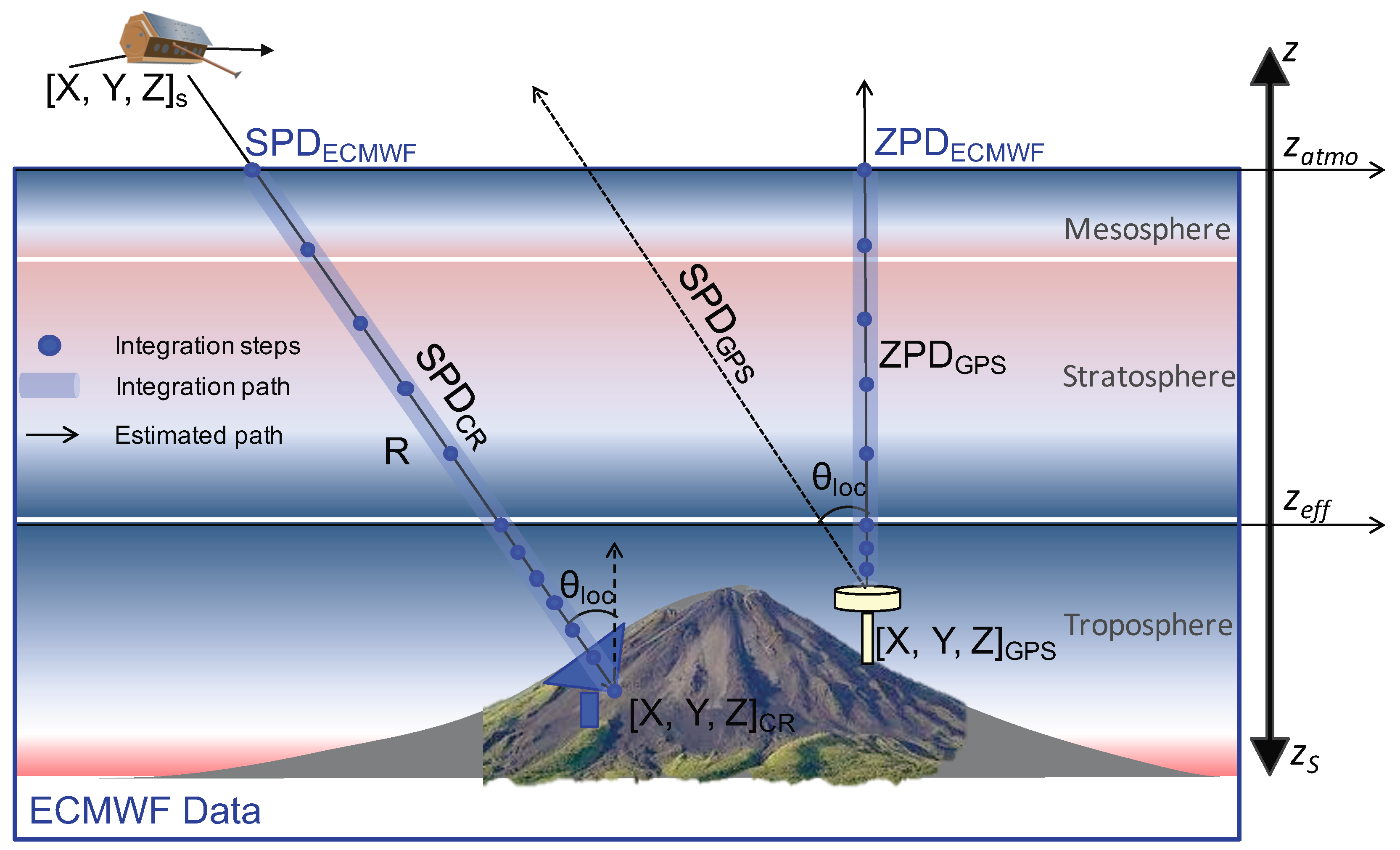
2.2. Direct Integration Method Using Global NWP Products
2.3. Terminology: Tropospheric Delay
3. Validation of Integrated Tropospheric Delay
3.1. ECMWF Products
3.2. Validation Approaches
3.3. Validation of Integrated ZPD with GPS ZPD
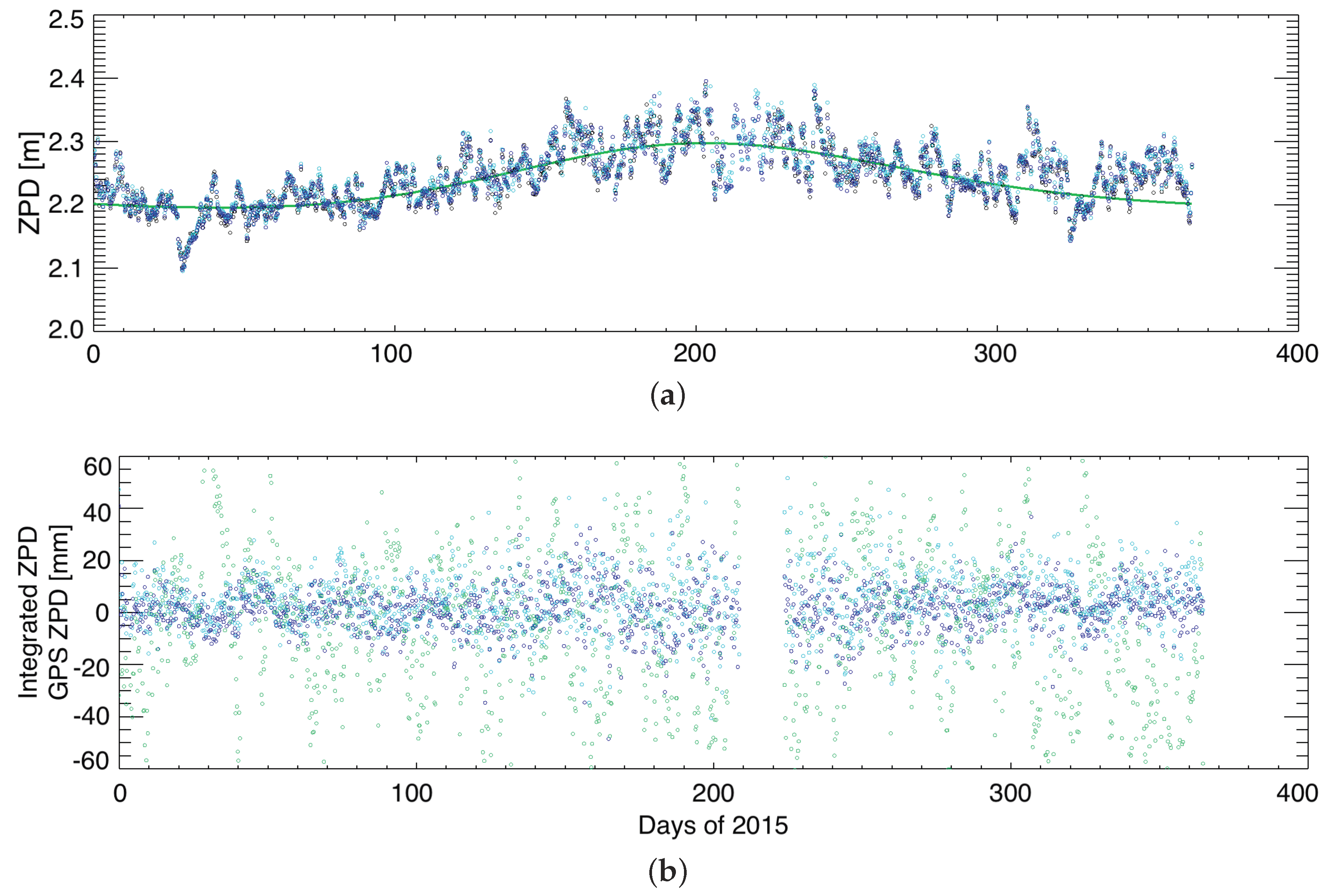
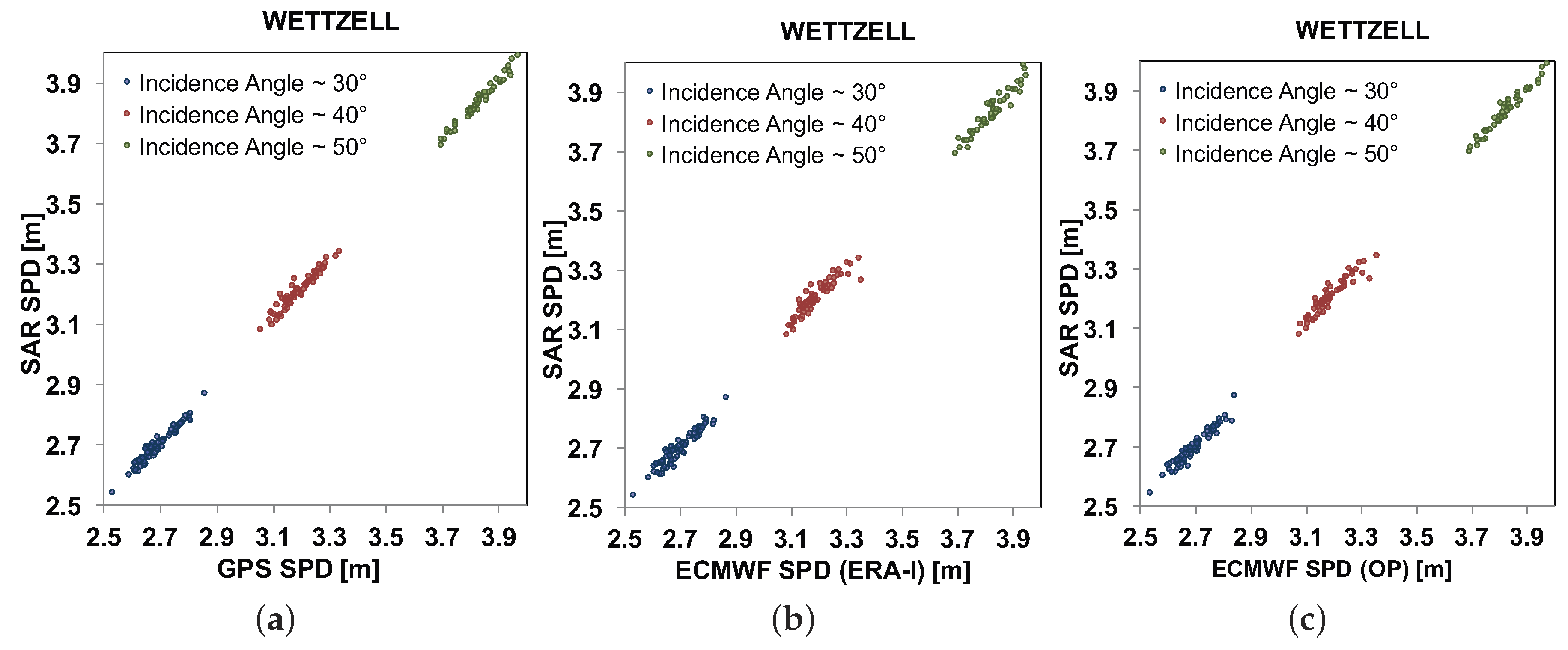
3.3.1. Time-Series Comparison Using ERA-Interim and OP Data Sets at the Wettzell Station
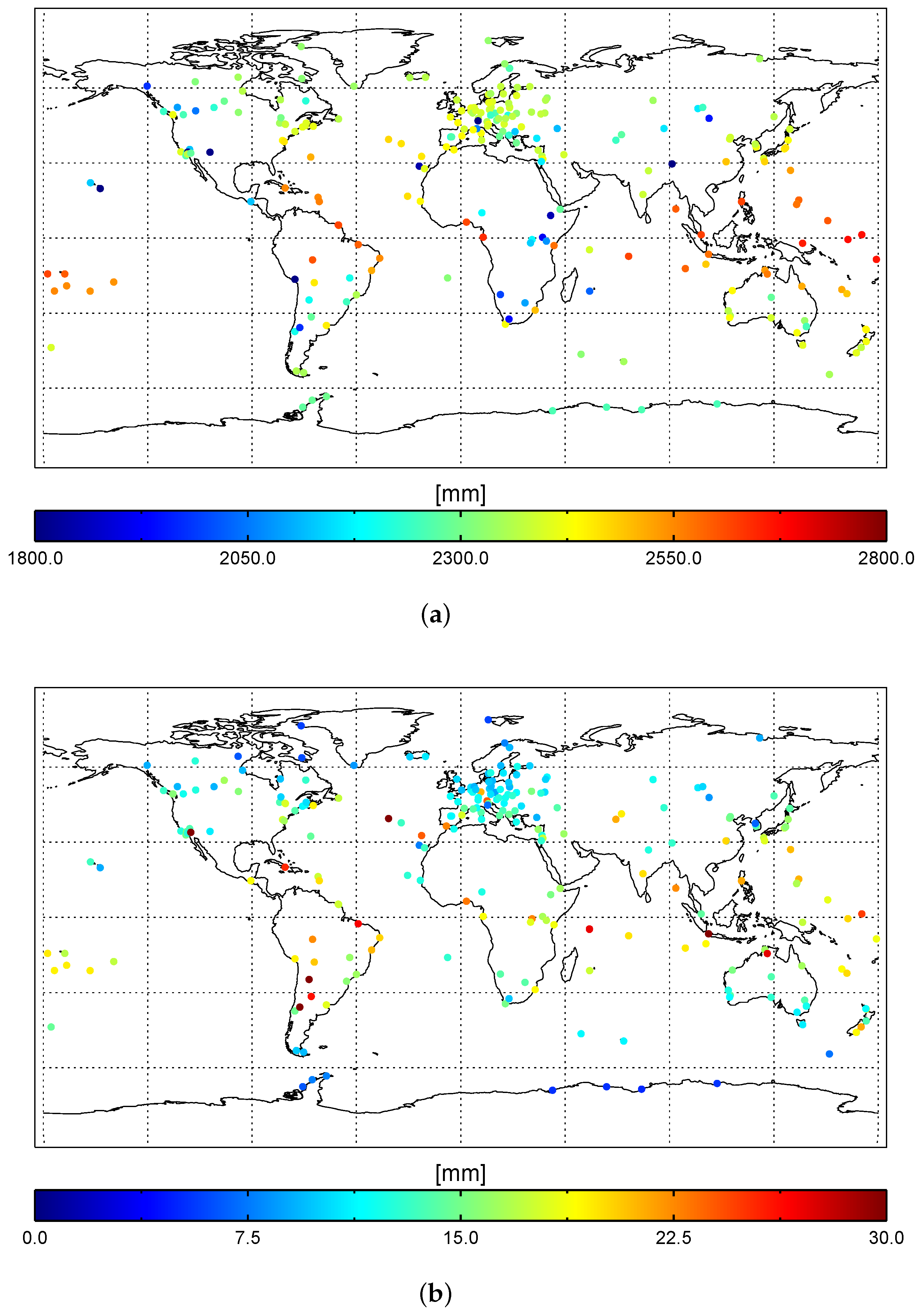
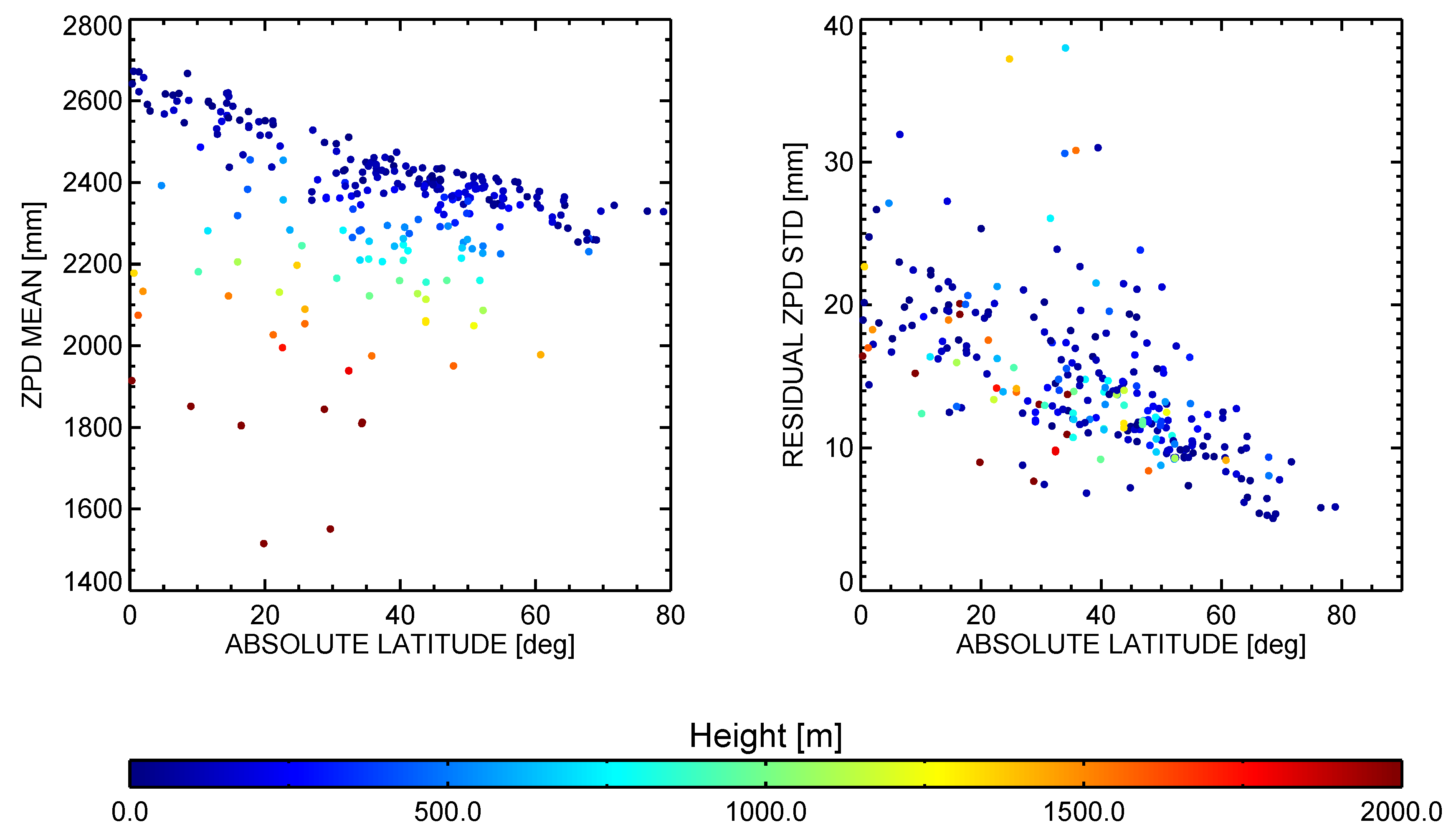
3.3.2. Global Validation of ERA-Interim Products
3.4. Validation of Integrated SPD with SPD Estimated from CR Measurements
4. Applications
4.1. Application to Absolute Ranging Measurements
4.2. Application to Interferometric Measurements
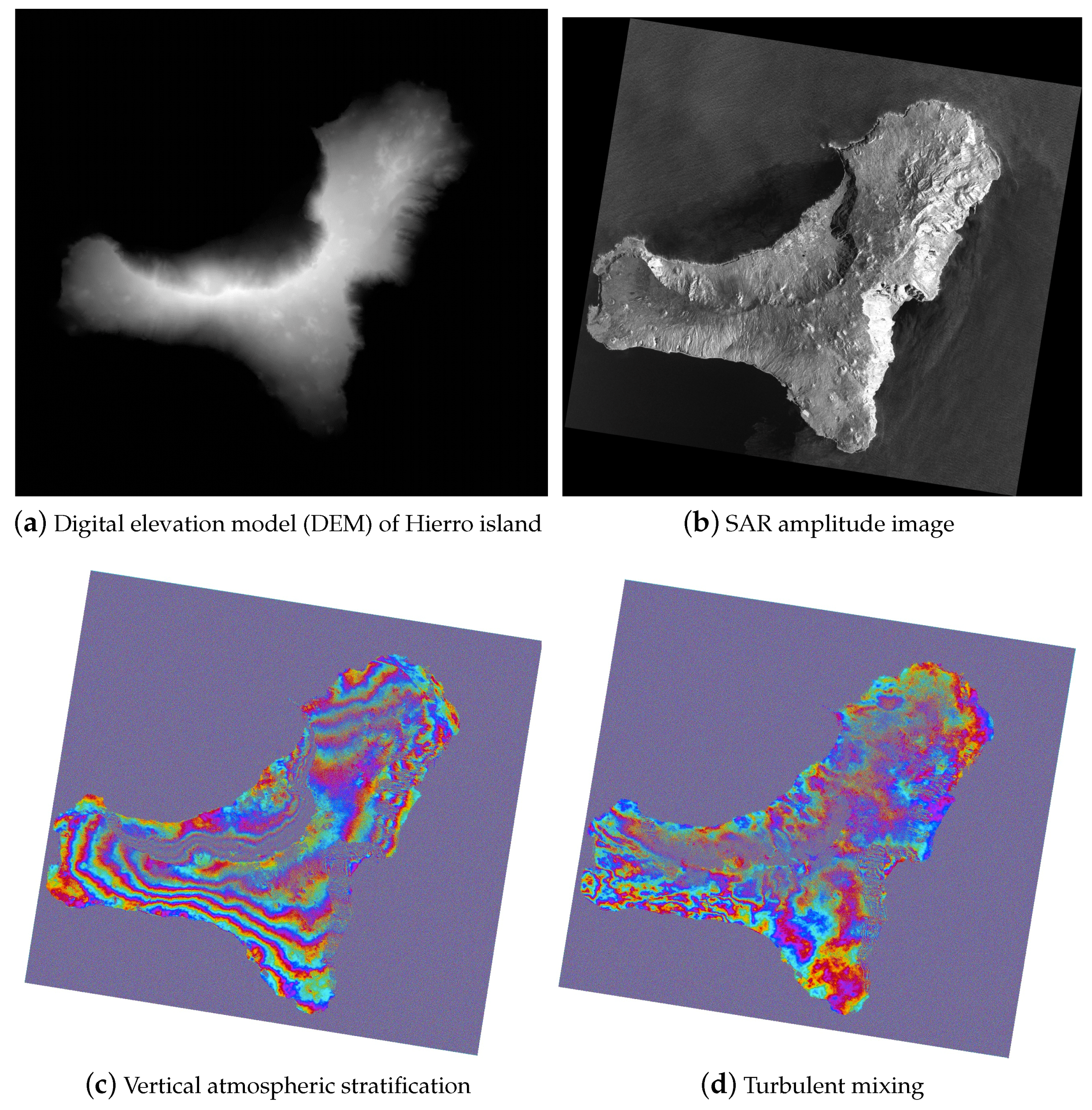
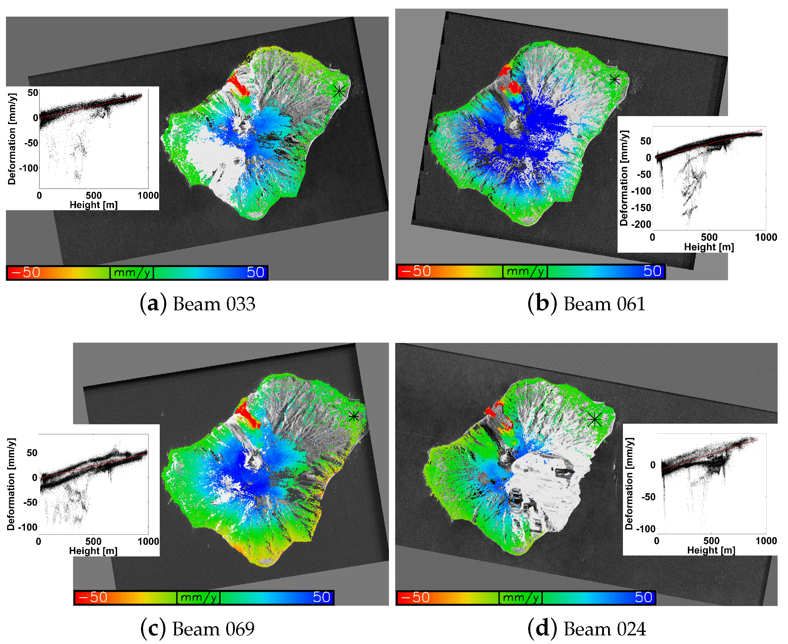
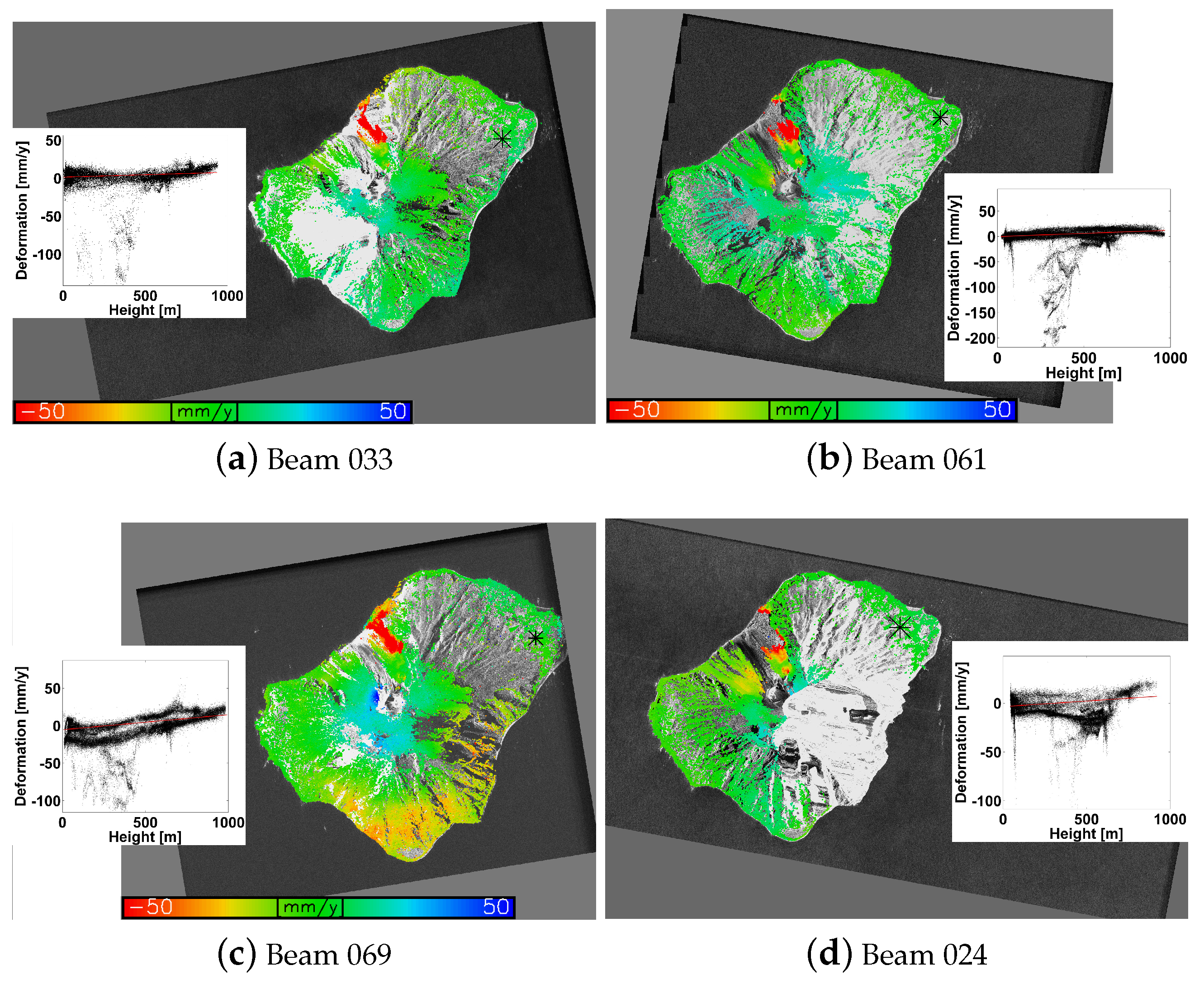
4.2.1. PSI Processing—Test Site: Stromboli Volcano, Italy
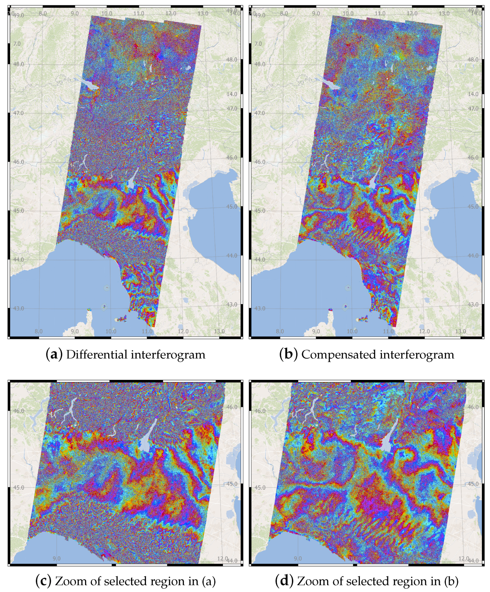
4.2.2. Wide Area Interferometry—Sentinel-1 Interferogram
5. Conclusions
Author Contributions
Acknowledgments
Conflicts of Interest
Abbreviations
| APL | Atmospheric pressure loading |
| ASC | Ascending |
| CD | Continental drift |
| CR | Corner reflector |
| DEM | Digital elevation model |
| DLR | German Aerospace Center |
| DSC | Descending |
| ECMWF | European Centre for Medium-Range Weather Forecasts |
| GNSS | Global navigation satellite system |
| GPS | Global positioning system |
| HRSL | High Resolution SpotLight |
| ID | Ionospheric delay |
| IFS | Integrated forecast system |
| IGS | International GNSS Service |
| InSAR | SAR interferometry |
| METS | CR test site in Metaähovi (Finland) |
| ML | Model level |
| NWP | Numerical weather prediction |
| OHIS | CR test site in GARS O’Higgins at the Antarctic Peninsula |
| OMT | Overall model test |
| OP | Operational data |
| OTL | Ocean tidal loading. |
| PSI | Persistent Scatterer (PS) interferometry |
| SAR | Synthetic aperture radar |
| SCR | Signal-to-Clutter Ratio |
| SET | Solid Earth tide |
| SPD | Slant range path delay |
| SWD | Slant range wet delay |
| TEC | Total electron content. |
| TDX-1 | German TanDEM-X satellite |
| TSX-1 | German TerraSAR-X satellite |
| WTZR | Wettzell GNSS station in EPN (Germany) |
| ZHD | Zenith hydrostatic delay |
| ZPD | Zenith path delay |
| ZWD | Zenith wet delay |
References
- Balss, U.; Cong, X.Y.; Brcic, R.; Rexer, M.; Minet, C.; Breit, H.; Fritz, T. High precision measurement on the absolute localization accuracy of TerraSAR-X. In Proceedings of the 2012 IEEE International Geoscience and Remote Sensing Symposium, Munich, Germany, 22–27 July 2012; pp. 1625–1628. [Google Scholar]
- Gisinger, C. Atmospheric Corrections for TerraSAR-X Derived from GNSS Observations. Master’s Thesis, Technische Universität München, Munich, Germany, 2012; pp. 1–117. [Google Scholar]
- Bamler, R.; Eineder, M. Split-band interferometry versus absolute ranging with wideband SAR systems. In Proceedings of the 2004 IEEE International Geoscience and Remote Sensing Symposium, Anchorage, AK, USA, 20–24 September 2004; pp. 980–984. [Google Scholar]
- Brcic, R.; Parizzi, A.; Eineder, M.; Bamler, R.; Meyer, F. Ionospheric effects in SAR interferometry: An analysis and comparison of methods for their estimation. In Proceedings of the 2011 IEEE International Geoscience and Remote Sensing Symposium, Vancouver, BC, Canada, 24–29 July 2011; pp. 1497–1500. [Google Scholar]
- Askne, J.; Nordius, H. Estimation of tropospheric delay for microwaves from surface weather data. Radio Sci. 1987, 22, 379–386. [Google Scholar] [CrossRef]
- Delacourt, C.; Briole, P.; Achache, J. Tropospheric corrections of SAR interferograms with strong topography application to Etna. Geophys. Res. Lett. 1998, 25, 2849–2852. [Google Scholar] [CrossRef]
- Li, Z.; Muller, J.-P.; Cross, P.; Fielding, E.J. Interferometric synthetic aperture radar (InSAR) atmospheric correction: GPS, Moderate Resolution Imaging Spectroradiometer (MODIS), and InSAR integration. J. Geophys. Res. Solid Earth 2005, 110, 2156–2202. [Google Scholar] [CrossRef]
- Cimini, D.; Pierdicca, N.; Pichelli, E.; Ferretti, R.; Mattioli, V.; Bonafoni, S.; Montopoli, M.; Perissin, D. On the accuracy of integrated water vapor observations and the potential for mitigating electromagnetic path delay error in InSAR. Atmos. Meas. Tech. Dis. 2012, 5, 1015–1030. [Google Scholar] [CrossRef]
- Jehle, M.; Perler, D.; Small, D.; Schubert, A.; Meier, E. Estimation of atmospheric path delays in TerraSAR-X data using models vs. measurements. Sensors 2008, 8, 8479–8491. [Google Scholar] [CrossRef] [PubMed]
- Cong, X.; Balss, U.; Eineder, M.; Fritz, T. Imaging Geodesy-Centimeter-level anging accuracy with TerraSAR-X: An update. IEEE Geosci. Remote Sens. Lett. 2012, 9, 948–952. [Google Scholar] [CrossRef]
- Nico, G.; Tomé, R.; Catalão, J.; Miranda, P.M.A. On the use of the WRF Model to mitigate tropospheric phase delay effects in SAR interferograms. IEEE Geosci. Remote Sens. Lett. 2011, 49, 948–952. [Google Scholar] [CrossRef]
- Catalão, J.; Nico, G.; Hanssen, R.F.; Catita, C. Merging GPS and atmospherically corrected InSAR data to map 3-D terrain displacement velocity. IEEE Geosci. Remote Sens. Lett. 2011, 49, 2354–2360. [Google Scholar] [CrossRef]
- Mateus, P.; Nico, G.; Tomé, R.; Catalão, J.; Miranda, P.M. Experimental study on the atmospheric delay based on GPS, SAR interferometry, and numerical weather model data. IEEE Geosci. Remote Sens. 2013, 51, 6–11. [Google Scholar] [CrossRef]
- Doin, M.-P.; Lasserre, C.; Peltzer, G.; Cavalié, O.; Doubre, C. Corrections of stratified tropospheric delays in SAR interferometry: Validation with global atmospheric models. J. Appl. Geophys. 2009, 69, 35–50. [Google Scholar] [CrossRef]
- Jolivet, R.; Agram, P.S.; Lin, N.Y.; Simons, M.; Doin, M.-P.; Peltzer, G.; Li, Z. Improving InSAR geodesy using global atmospheric models. J. Geophys. Res. Solid Earth 2014, 119, 2324–2341. [Google Scholar] [CrossRef]
- Wallace, J.M.; Hobbs, P.V. Atmospheric Science: An Introductory Survey; Elsevier Inc.: New York, NY, USA, 2006; 505p, ISBN 9780127329512. [Google Scholar]
- Hanssen, R.F. Radar Interferometry: Data Interpretation and Error Analysis; Springer: Berlin, Germany, 2001; ISBN 9780306476334. [Google Scholar]
- Smith, E.K.; Weintraubt, S. The constants in the equation for atmospheric refractive index at radio frequencies. Proc. IRE 1953, 41, 1035–1037. [Google Scholar] [CrossRef]
- Healy, S.B. Refractivity coefficients used in the assimilation of GPS radio occultation measurements. J. Geophys. Res. 2011, 116, 1–10. [Google Scholar] [CrossRef]
- Nafisi, V.; Urquhart, L.; Santos, M.C.; Nievinski, F.G.; Bohm, J.; Wijaya, D.D.; Zus, F. Comparison of ray-tracing packages for troposphere delays. IEEE Geosci. Remote Sens. 2012, 50, 469–481. [Google Scholar] [CrossRef]
- Saastamoinen, J. Atmospheric correction for the troposphere and stratosphere in radio ranging satellites. Geophys. Monogr. Ser. 1972, 15, 247–251. [Google Scholar]
- Thayer, G.D. An improved equation for the radio refractive index of air. Radio Sci. 1974, 9, 803–807. [Google Scholar] [CrossRef]
- Davis, J.L.; Herring, T.A.; Shapiro, I.I.; Rogers, A.E.E.; Elgered, G. Geodesy by radio interferometry: Effects of atmospheric modeling errors on estimates of baseline length. Radio Sci. 1985, 20, 1593–1607. [Google Scholar] [CrossRef]
- Bevis, M.; Businger, S.; Chiswell, S.; Herring, T.A.; Anthes, R.A.; Rocken, C.; Ware, R.H. An improved equation for the radio refractive index of air. J. Appl. Meteorol. 1994, 33, 379–386. [Google Scholar] [CrossRef]
- Rüeger, J.M. Refractive index formulae for radio waves. In Integration of Techniques and Corrections to Achieve Accurate Engineering. In Proceedings of the XXII FIG International Congress ACSM/SPRS Annual Conference, Washington, DC, USA, 19–26 April 2002; pp. 19–26. [Google Scholar]
- Cong, X. SAR Interferometry for Volcano Monitoring: 3D-PSI Analysis and Mitigation of Atmospheric Refractivity. Doctoral dissertation, Technische Universität München, Munich, Germany, 2014. [Google Scholar]
- Povic, J. ETA Model in Weather Forecast. Royal Institute of Technology, 2006. Available online: www.nada.kth.se/utbildning/grukth/exjobb/rapportlistor/2006/rapporter06/popovic_jelena_06054.pdf (accessed on 23 July 2018).
- Dee, D.P.; Uppala, S.M.; Simmons, A.J.; Berrisford, P.; Poli, P.; Kobayashi, S.; Andrae, U.; Balmaseda, M.A.; Balsamo, G.; Bauer, D.P.; et al. The ERA-Interim reanalysis: Configuration and performance of the data assimilation system. Q. J. R. Meteorol. Soc. 2011, 137, 553–597. [Google Scholar] [CrossRef]
- Hersbach, H.; Dee, D. ERA5 reanalysis is in production. ECMWF Newslett. 2016, 147, 7. [Google Scholar]
- Bock, O.; Keil, C.; Richard, E.; Flamant, C.; Bouin, M.-N. Validation of precipitable water from ECMWF model analyses with GPS and radiosonde data during the MAP SOP. Q. J. R. Meteorol. Soc. 2005, 131, 3013–3036. [Google Scholar] [CrossRef]
- Flentje, H.; Dörnbrack, A.; Fix, A.; Ehret, G.; Hólm, E. Evaluation of ECMWF water vapour fields by airborne differential absorption lidar measurements: A case study between Brazil and Europe. Atmos. Chem. Phys. 2007, 7, 5033–5042. [Google Scholar] [CrossRef]
- Schäfler, A.; Dörnbrack, A.; Kiemle, C.; Rahm, S.; Wirth, M. Tropospheric water vapor transport as determined from airborne Lidar measurements. J. Atmos. Ocean. Technol. 2010, 27, 2017–2030. [Google Scholar] [CrossRef]
- Schäfler, A.; Dörnbrack, A.; Wernli, H.; Kiemle, C.; Pfahl, S. Airborne lidar observations in the inflow region of a warm conveyor belt. Q. J. R. Meteorol. Soc. 2011, 137, 1257–1272. [Google Scholar] [CrossRef]
- Eineder, M.; Minet, C.; Steigenberger, P.; Cong, X.; Fritz, T. Imaging geodesy-Toward centimeter-level ranging accuracy with TerraSAR-X. IEEE Geosci. Remote Sens. 2011, 49, 661–671. [Google Scholar] [CrossRef]
- Dow, J.M.; Neilan, R.; Rizos, C. The international GNSS service in a changing landscape of global navigation satellite systems. J. Geod. 2009, 83, 191–198. [Google Scholar] [CrossRef]
- Bevis, M.; Businger, S.; Herring, T.A.; Rocken, C.; Anthes, R.A.; Ware, R.H. GPS meteorology: Remote sensing of atmospheric water vapor using the global positioning system. J. Geophys. Res. 1992, 97, 787–801. [Google Scholar] [CrossRef]
- Tregoning, P.; Boers, R.; O’Brien, D. Accuracy of absolute precipitable water vapor estimates from GPS observations. J. Geophys. Res. 1998, 103, 28701–28710. [Google Scholar] [CrossRef]
- Niell, A.E. Improved atmospheric mapping functions for VLBI and GPS. Earth Planets Sci. Lett. 2000, 52, 699–702. [Google Scholar] [CrossRef]
- Kacmarík, M.; Douša, J.; Dick, G.; Zus, F.; Brenot, H.; Möller, G.; Pottiaux, E.; Kapłon, J.; Hordyniec, P.; Václavovic, P.; et al. Inter-technique validation of tropospheric slant total delays. Atmos. Meas. Tech. 2017, 10, 2183–2208. [Google Scholar] [CrossRef]
- Böhm, J.; Möller, G.; Schindelegger, M.; Pain, G.; Weber, R. Development of an improved empirical model for slant delays in the troposphere (GPT2w). GPS Solut. 2005, 19, 433–441. [Google Scholar] [CrossRef]
- DGordon, N.D.; Jonko, A.K.; Forster, P.M.; Shell, K.M. An observationally based constraint on the water-vapor feedback. J. Geophs. Res. Atmos. 2013, 118, 12–435. [Google Scholar]
- Balss, U.; Breit, H.; Fritz, T.; Steinbrecher, U.; Gisinger, C.; Eineder, M. Analysis of internal timings and clock rates of TerraSAR-X. In Proceedings of the 2014 IEEE Geoscience and Remote Sensing Symposium, Quebec City, QC, Canada, 13–18 July 2014; pp. 2671–2674. [Google Scholar]
- Balss, U.; Gisinger, C.; Cong, X.Y.; Brcic, R.; Hackel, S.; Eineder, M. Precise Measurements on the Absolute Localization Accuracy of TerraSAR-X on the Base of Far-Distributed Test Sites. In Proceedings of the 10th European Conference on Synthetic Aperture Radar (EUSAR 2014), Berlin, Germany, 3–5 June 2014; pp. 993–996. [Google Scholar]
- Balss, U.; Gisinger, C.; Eineder, M. Measurements on the Absolute 2-D and 3-D Localization Accuracy of TerraSAR-X. Remote Sens. 2018, 10, 656. [Google Scholar] [CrossRef]
- Gernhardt, S.M. High Precision 3D Localization and Motion Analysis of Persistent Scatterers Using Meter-Resolution Radar Satellite Data. Doctoral dissertation, Technische Universität München, Munich, Germany, 2011. [Google Scholar]
- Kampes, B.M. Radar Interferometry: Persistent Scatterer Technique; Springer: Berlin, Germany, 2006. [Google Scholar]
- Rodriguze Gonzalez, F.; Adam, N.; Parizzi, A.; Brcic, R. The Integrated Wide Area Processor (IWAP): A processor for wide area persistent scatterer interferometry. ESA Liv. Planet Symp. 2013, 722, 353. [Google Scholar]
- Eineder, M.; Balss, U.; Suchandt, S.; Gisinger, C.; Cong, X.; Runge, H. A definition of next-generation SAR products for geodetic applications. In Proceedings of the 2015 IEEE International Geoscience and Remote Sensing Symposium (IGARSS), Milan, Italy, 26–31 July 2015; pp. 1638–1641. [Google Scholar]
- Pichelli, E.; Ferretti, R.; Cimini, D.; Panegrossi, G.; Perissin, D.; Pierdicca, N.; Rommen, B. InSAR water vapor data assimilation into mesoscale model MM5: Technique and pilot study. IEEE J. Sel. Top. Appl. Earth Obs. Remote Sens. 2015, 8, 3859–3875. [Google Scholar] [CrossRef]
- Mateus, P.; Miranda, P.M.A.; Nico, G.; Catalão, J.; Pinto, P.; Tomé, R. Assimilating InSAR maps of water vapor to improve heavy rainfall forecasts: A case study with two successive storms. J. Geophys. Res. 2018, 123, 1638–1641. [Google Scholar] [CrossRef]


| Authors (Year) | (K/hPa) | (K/hPa) | (K/ hPa) | ZPD Diff. (mm) | |
|---|---|---|---|---|---|
| Mean | Std | ||||
| Ideal Gas | |||||
| Smith and Weintraubt [18] | |||||
| Saastamoinen [21] | |||||
| Rüeger [25] (best available) | <0.1 | ||||
| Rüeger [25] (best average) | <0.1 | ||||
| Healy [19] | <0.1 | ||||
| Non-ideal Gases | |||||
| Thayer [22] | |||||
| Davis et al. [23] | |||||
| Healy [19] | |||||
| Non-ideal Gases—Approximated Equation | |||||
| Bevis et al. [24] | |||||
| ECMWF Products | Horizontal Resolution (deg) | Vertical Resolution | IFS Release | Release Date |
|---|---|---|---|---|
| Operational | 0.100 | 137-Level | Cycle 41r2 | 8 March 2016 |
| 0.125 | 137-Level | Cycle 38r2 | 26 June 2013 | |
| 0.125 | 91-Level | Cycle 38r1 | 11 March 2008 | |
| 0.225 | 91-Level | Cycle 30r1 | 1 February 2006 | |
| 0.350 | 60-Level | Cycle 23r3 | 21 November 2000 | |
| ERA-Interim | 0.750 | 60-Level | Cycle 31r2 | 1 January 2006 |
| ERA5 | 0.280 | 137-Level | Cycle 41r2 | 1 January 2018 |
| CR ID | Input Data | Mean (mm) | STD (mm) |
|---|---|---|---|
| WTZR 01 (ASC) | GPS ZPD | ||
| ERA-Interim | |||
| Operational | |||
| WTZR 02 (DSC) | GPS ZPD | ||
| ERA-Interim | |||
| Operational | |||
| METS (DSC) | GPS ZPD | ||
| ERA-Interim | |||
| Operational |
| Test Site Code | Crossing Orbit Direction | IGS SPD | ECMWF SPD | ||
|---|---|---|---|---|---|
| Mean (mm) | STD (mm) | Mean (mm) | STD [mm] | ||
| WTZR | ASC | ||||
| DSC | |||||
| OHIS | ASC | ||||
| DSC | |||||
| METS | DSC | ||||
| Beam | (mm/year) | (m) | ||||
|---|---|---|---|---|---|---|
| Nr. | Max | Min | Corr. (-) | Max | Min | Corr. (-) |
| 033 | ||||||
| 061 | ||||||
| 069 | ||||||
| 024 | ||||||
© 2018 by the authors. Licensee MDPI, Basel, Switzerland. This article is an open access article distributed under the terms and conditions of the Creative Commons Attribution (CC BY) license (http://creativecommons.org/licenses/by/4.0/).
Share and Cite
Cong, X.; Balss, U.; Rodriguez Gonzalez, F.; Eineder, M. Mitigation of Tropospheric Delay in SAR and InSAR Using NWP Data: Its Validation and Application Examples. Remote Sens. 2018, 10, 1515. https://doi.org/10.3390/rs10101515
Cong X, Balss U, Rodriguez Gonzalez F, Eineder M. Mitigation of Tropospheric Delay in SAR and InSAR Using NWP Data: Its Validation and Application Examples. Remote Sensing. 2018; 10(10):1515. https://doi.org/10.3390/rs10101515
Chicago/Turabian StyleCong, Xiaoying, Ulrich Balss, Fernando Rodriguez Gonzalez, and Michael Eineder. 2018. "Mitigation of Tropospheric Delay in SAR and InSAR Using NWP Data: Its Validation and Application Examples" Remote Sensing 10, no. 10: 1515. https://doi.org/10.3390/rs10101515
APA StyleCong, X., Balss, U., Rodriguez Gonzalez, F., & Eineder, M. (2018). Mitigation of Tropospheric Delay in SAR and InSAR Using NWP Data: Its Validation and Application Examples. Remote Sensing, 10(10), 1515. https://doi.org/10.3390/rs10101515