Examining Land Cover and Greenness Dynamics in Hangzhou Bay in 1985–2016 Using Landsat Time-Series Data

Abstract
:
1. Introduction
2. Materials and Methods
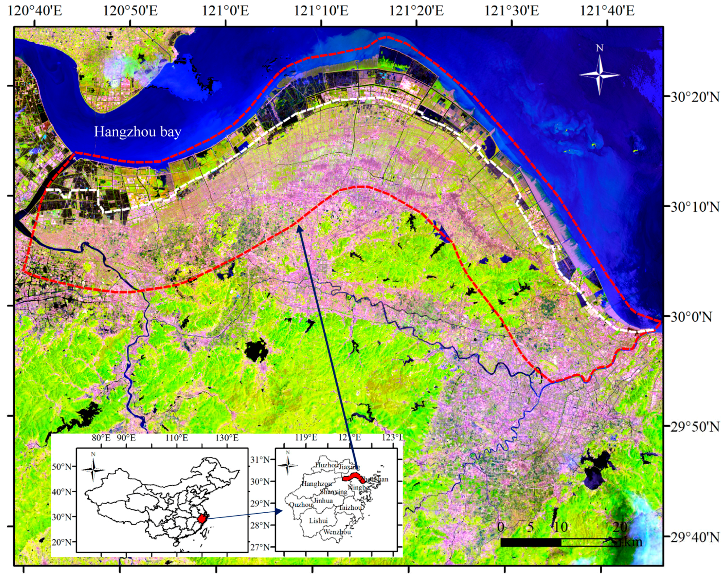
2.1. Study Area
2.2. Data Preparation
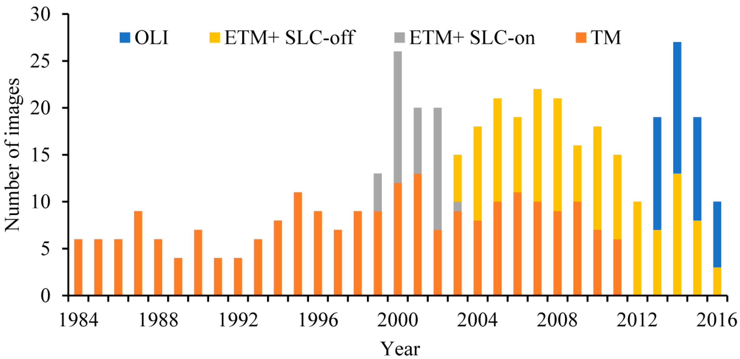
2.2.1. Collection of Landsat Imagery and Calculation of Vegetation Indices
2.2.2. Collection of Land Cover Reference Data
2.3. Time Series Model and Change Detection Analysis
2.4. Continuous Land Cover Classification
2.5. Trends Analysis of NDVI Time-Series Data
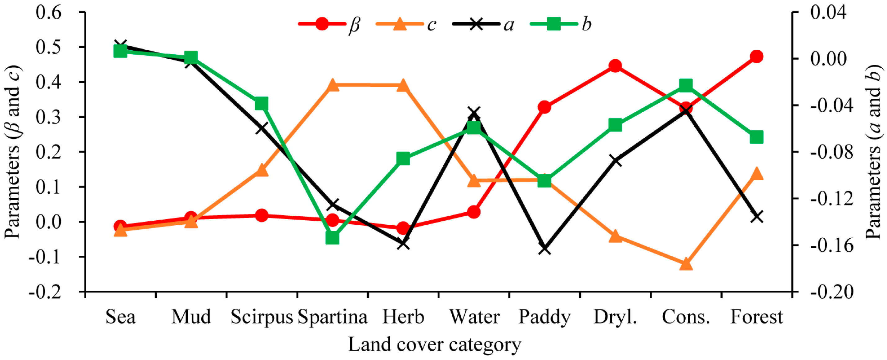
2.6. Impacts of Land Cover Change on Vegetation Greenness Dynamics
2.7. Accuracy Assessment and Validation
2.7.1. Assessment of Breakpoints Detection Results
2.7.2. Assessment of Land Cover Classification
3. Results
3.1. Accuracy Assessment of Change Detection and Classification
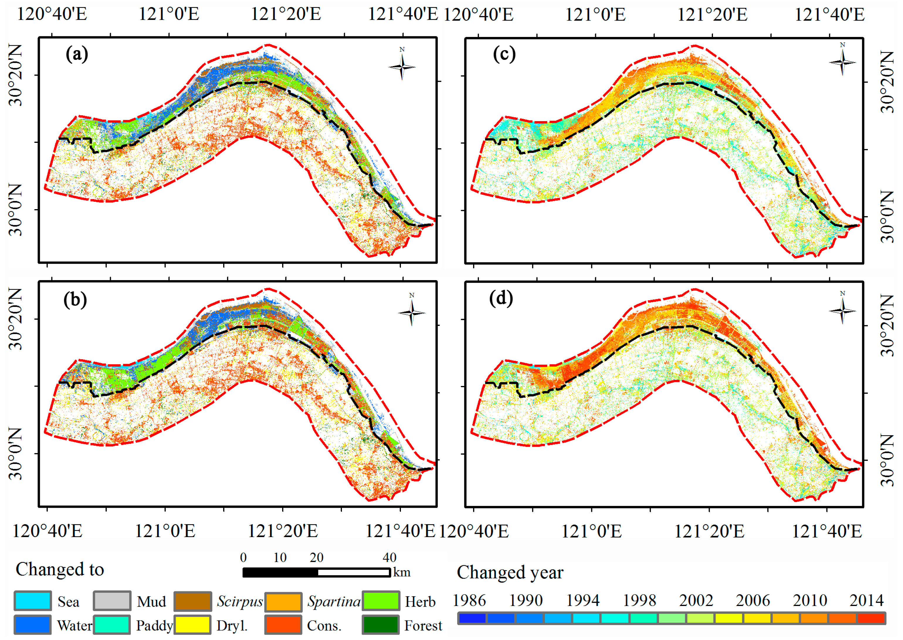
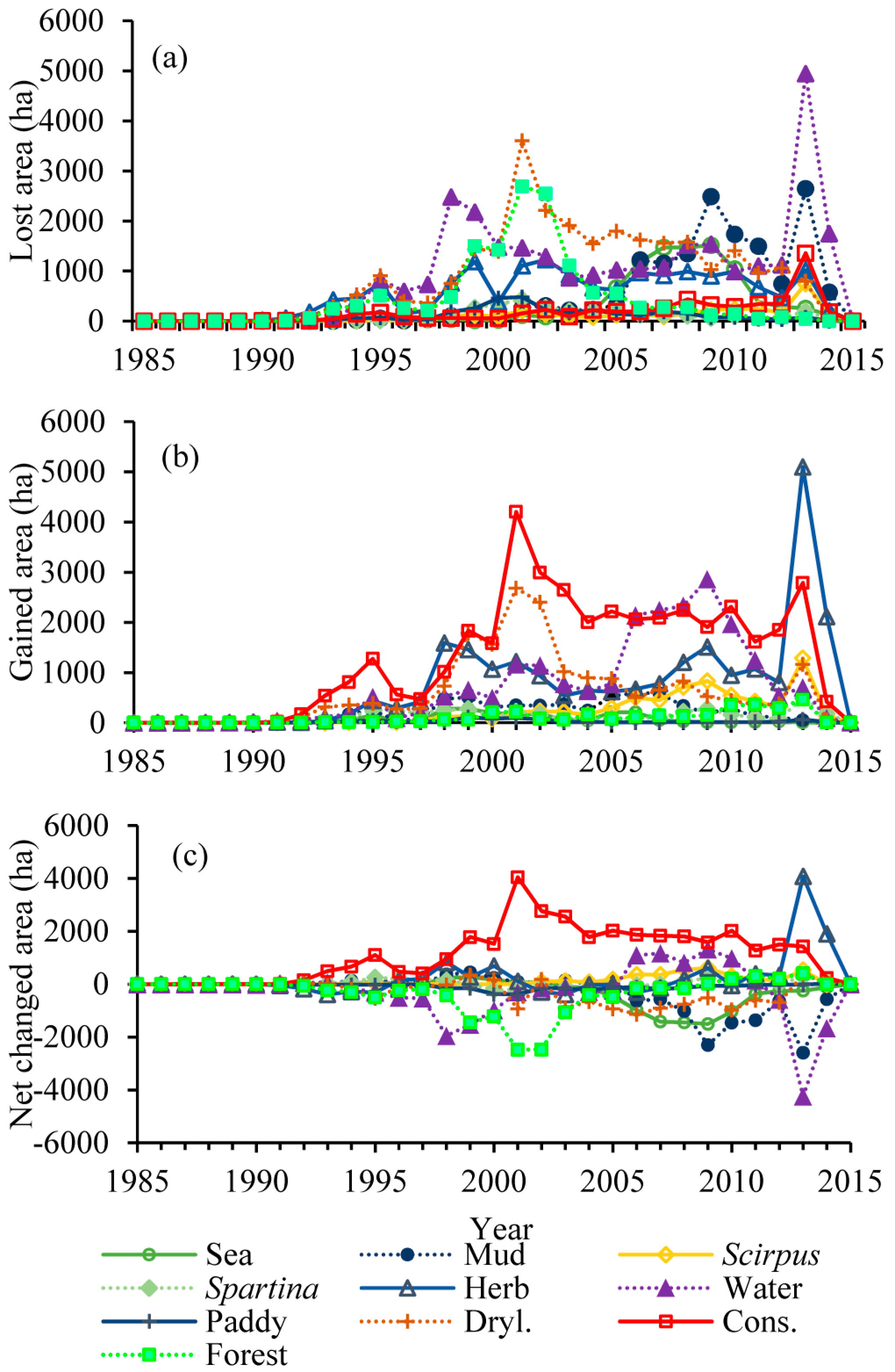
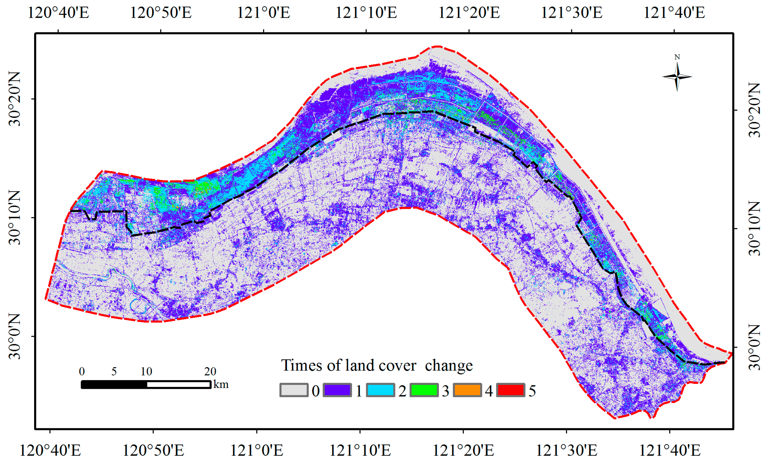
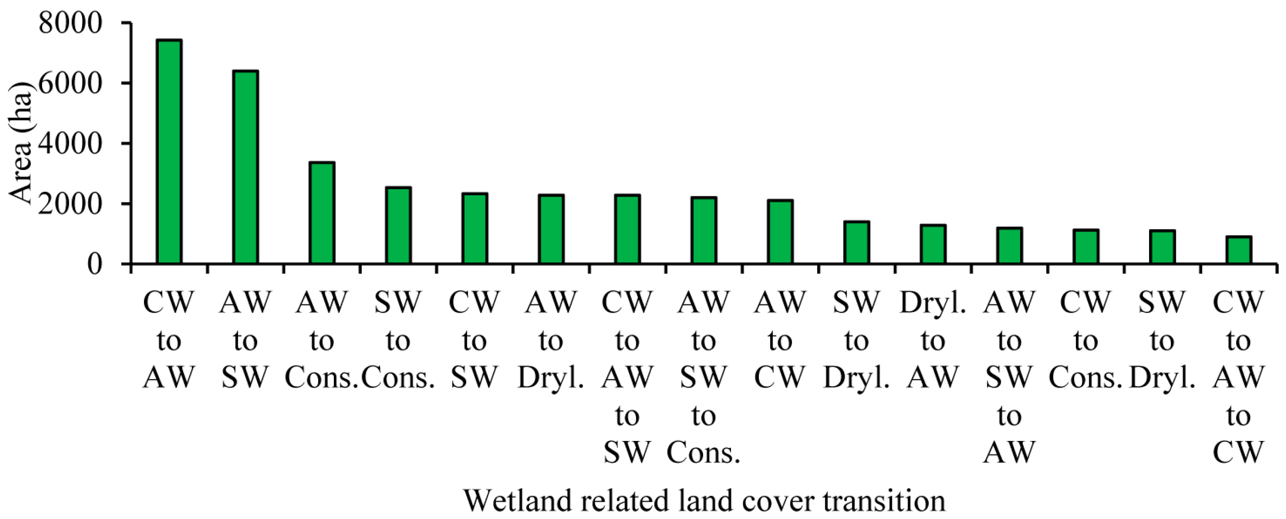
3.2. Intensity and Types of Land Cover Change
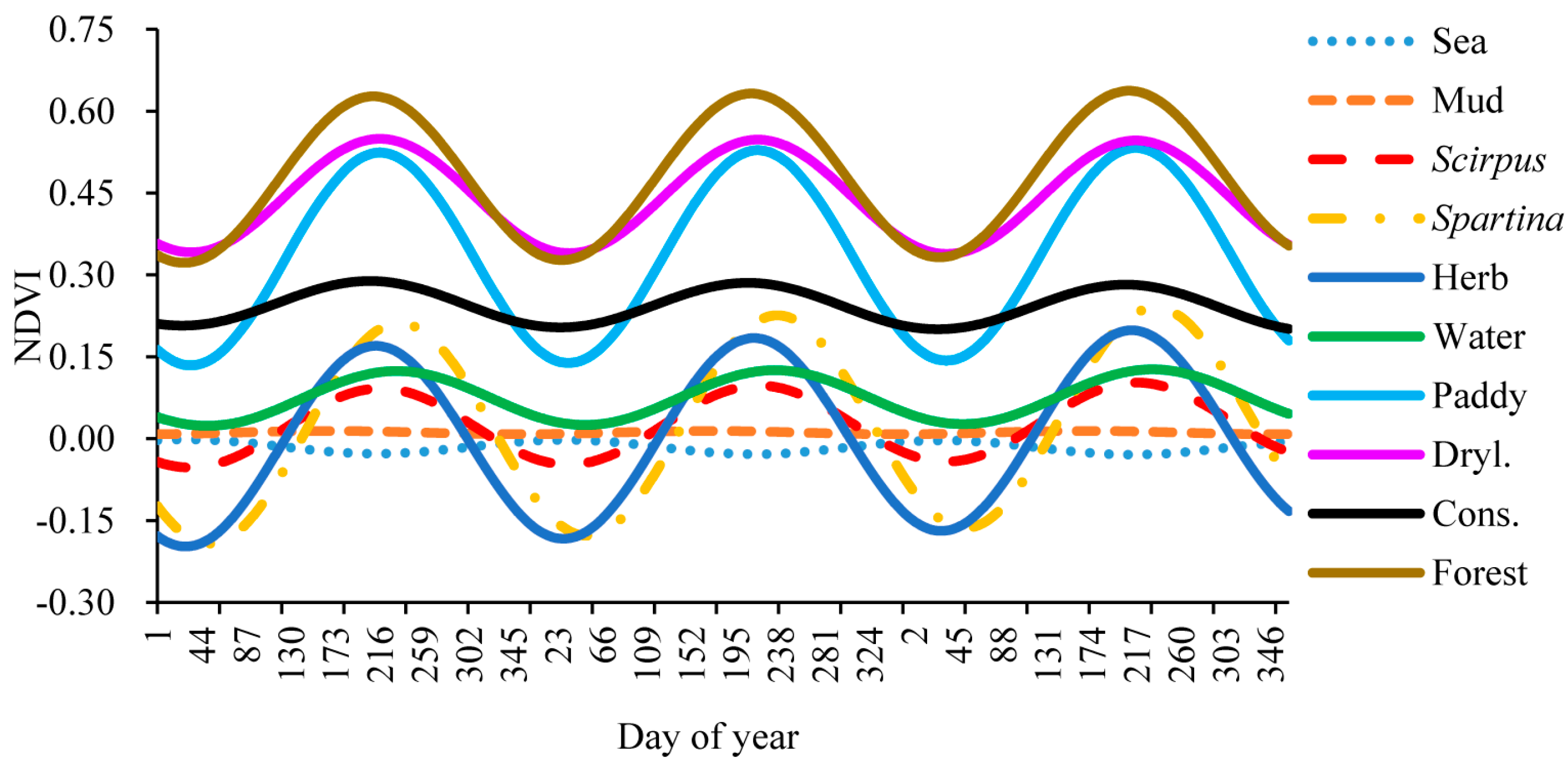
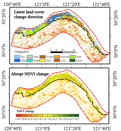
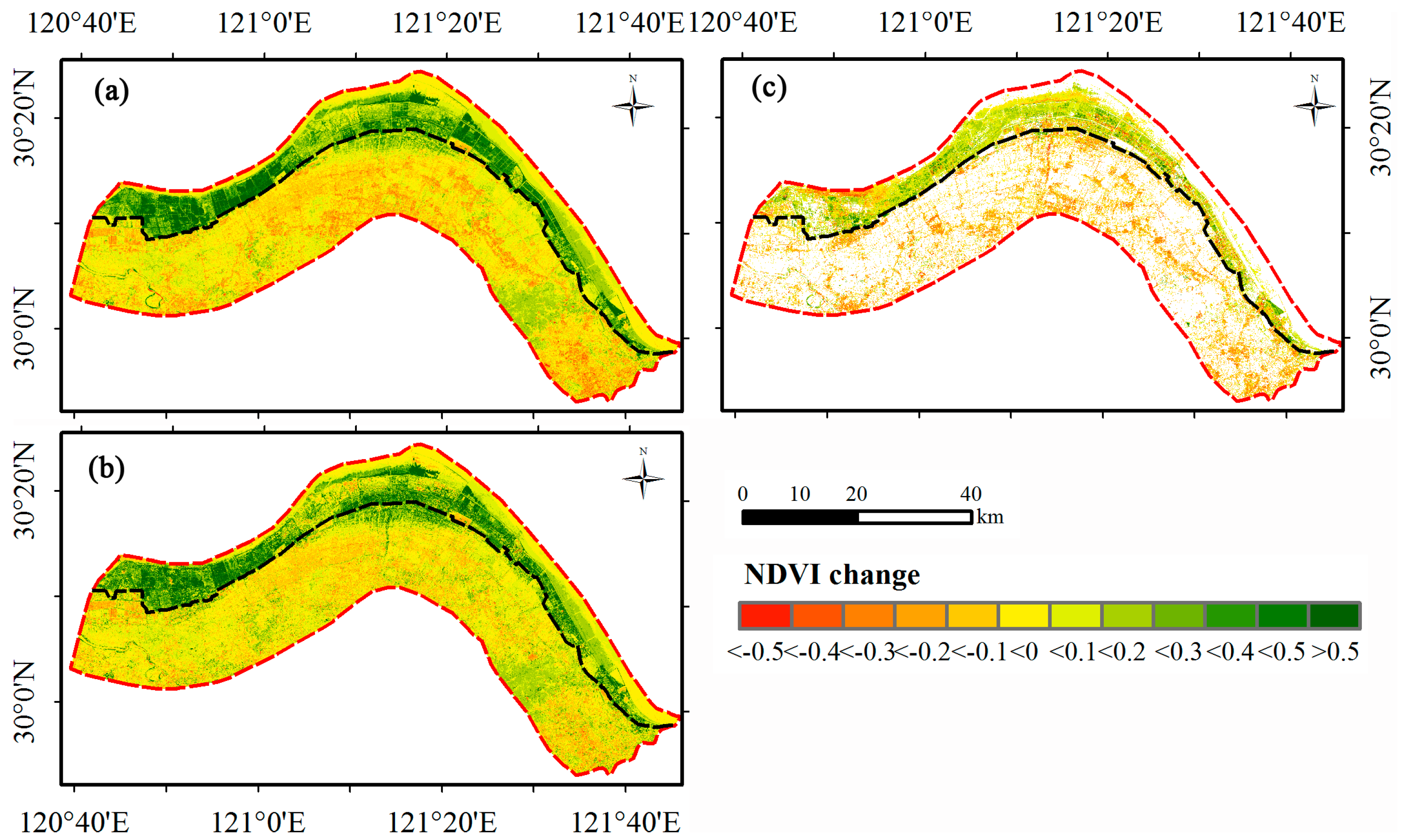
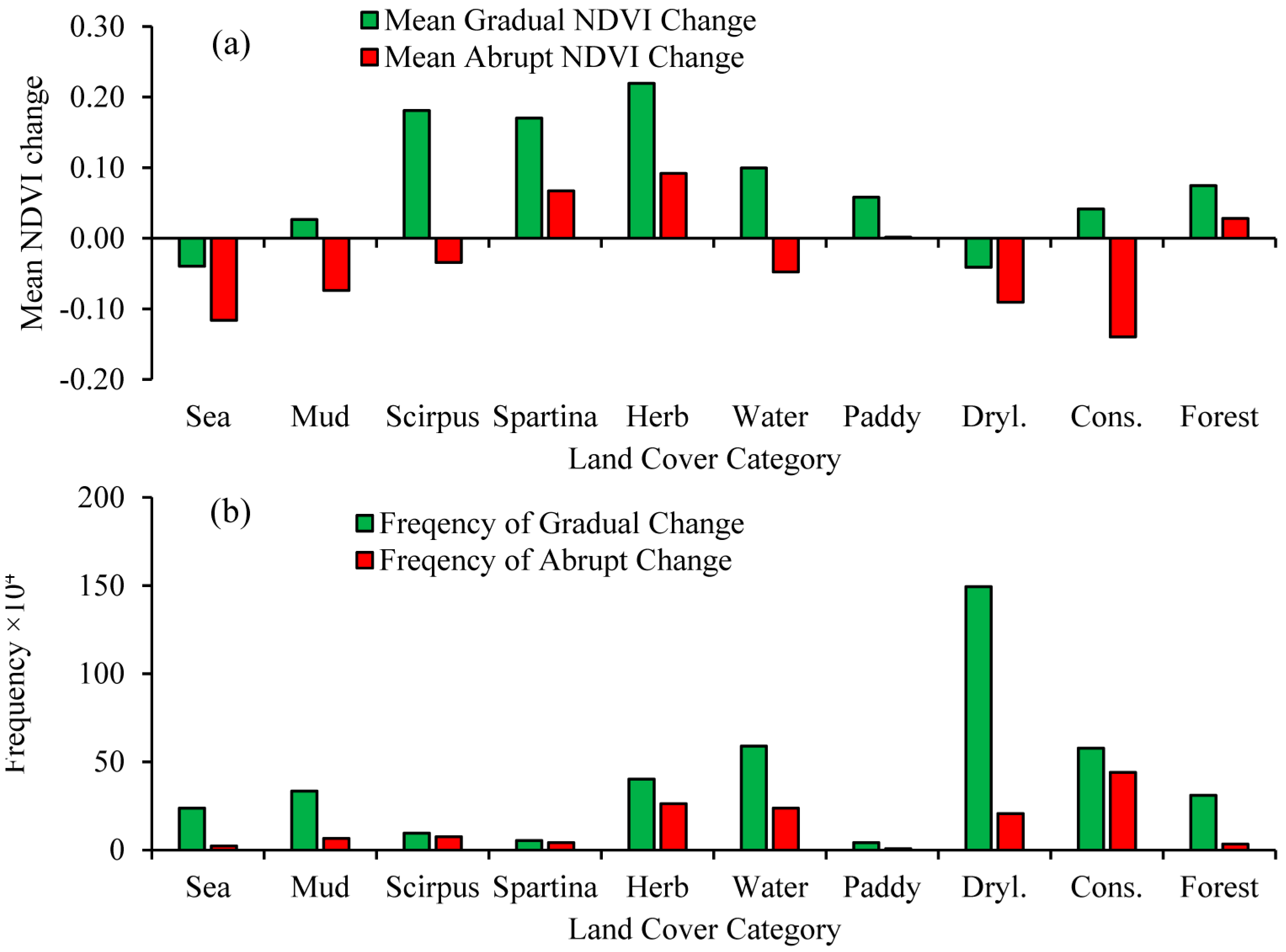
3.3. Analysis of Long-Term NDVI Trends and Their Relationship to Land Cover Change
4. Discussion
4.1. Uncertainties and Limitations of This Study
4.2. Drivers of Land Cover Change Dynamics in Hangzhou Bay
4.3. Impacts of Land Cover Change on Vegetation Greenness
5. Conclusions
Supplementary Materials
Acknowledgments
Author Contributions
Conflicts of Interest
References
- Rai, R.; Zhang, Y.; Paudel, B.; Li, S.; Khanal, N.R. A synthesis of studies on land use and land cover dynamics during 1930–2015 in Bangladesh. Sustainability 2017, 9, 1866. [Google Scholar] [CrossRef]
- Lambin, E.F.; Turner, B.L.; Geist, H.J.; Agbola, S.B.; Angelsen, A.; Bruce, J.W.; Coomes, O.T.; Dirzo, R.; Fischer, G.; Folke, C. The causes of land-use and land-cover change: Moving beyond the myths. Glob. Environ. Chang. 2001, 11, 261–269. [Google Scholar] [CrossRef]
- Gómez, C.; White, J.C.; Wulder, M.A. Optical remotely sensed time series data for land cover classification: A review. ISPRS J. Photogramm. Remote Sens. 2016, 116, 55–72. [Google Scholar] [CrossRef]
- Zhu, Z.; Fu, Y.; Woodcock, C.E.; Olofsson, P.; Vogelmann, J.E.; Holden, C.; Wang, M.; Dai, S.; Yu, Y. Including land cover change in analysis of greenness trends using all available Landsat 5, 7, and 8 images: A case study from Guangzhou, China (2000–2014). Remote Sens. Environ. 2016, 185, 243–257. [Google Scholar] [CrossRef]
- Wang, H.; Liu, G.; Li, Z.; Xin, Y.; Fu, B.; Lü, Y. Analysis of the driving forces in vegetation variation in the Grain for Green program region, China. Sustainability 2017, 9, 1853. [Google Scholar] [CrossRef]
- Wang, J.; Wang, K.; Zhang, M.; Zhang, C. Impacts of climate change and human activities on vegetation cover in hilly southern China. Ecol. Eng. 2015, 81, 451–461. [Google Scholar] [CrossRef]
- Piao, S.; Wang, X.; Ciais, P.; Zhu, B.; Wang, T.; Liu, J. Changes in satellite-derived vegetation growth trend in temperate and boreal Eurasia from 1982 to 2006. Glob. Chang. Biol. 2011, 17, 3228–3239. [Google Scholar] [CrossRef]
- Liu, X.; Zhu, X.; Li, S.; Liu, Y.; Pan, Y. Changes in growing season vegetation and their associated driving forces in China during 2001–2012. Remote Sens. 2015, 7, 15517–15535. [Google Scholar] [CrossRef]
- Fu, Y.; Lu, X.; Zhao, Y.; Zeng, X.; Xia, L. Assessment impacts of weather and land use/land cover (LULC) change on urban vegetation net primary productivity (NPP): A case study in Guangzhou, China. Remote Sens. 2013, 5, 4125–4144. [Google Scholar] [CrossRef]
- Pfner, C.H.; Scherer, D. Analysis of vegetation and land cover dynamics in north-western Morocco during the last decade using MODIS NDVI time series data. Biogeosciences 2011, 8, 3359–3373. [Google Scholar]
- Ye, X.; Zhang, Q.; Liu, J.; Li, X.; Xu, C.Y. Distinguishing the relative impacts of climate change and human activities on variation of streamflow in the Poyang lake catchment, China. J. Hydrol. 2013, 494, 83–95. [Google Scholar] [CrossRef]
- Jong, R.D.; Verbesselt, J.; Schaepman, M.E.; Bruin, S.D. Trend changes in global greening and browning: Contribution of short-term trends to longer-term change. Glob. Chang. Biol. 2012, 18, 642–655. [Google Scholar] [CrossRef]
- Piao, S.; Yin, G.; Tan, J.; Cheng, L.; Huang, M.; Li, Y.; Liu, R.; Mao, J.; Myneni, R.B.; Peng, S. Detection and attribution of vegetation greening trend in China over the last 30 years. Glob. Chang. Biol. 2015, 21, 1601–1609. [Google Scholar] [CrossRef] [PubMed]
- Wang, W.; Liu, H.; Li, Y.; Su, J. Development and management of land reclamation in China. Ocean Coast. Manag. 2014, 102, 415–425. [Google Scholar] [CrossRef]
- Hu, S.; Niu, Z.; Chen, Y.; Li, L.; Zhang, H. Global wetlands: Potential distribution, wetland loss, and status. Sci. Total Environ. 2017, 586, 319–327. [Google Scholar] [CrossRef] [PubMed]
- Yang, W.; Jin, Y.; Sun, T.; Yang, Z.; Cai, Y.; Yi, Y. Trade-offs among ecosystem services in coastal wetlands under the effects of reclamation activities. Ecol. Indic. 2017, in press. [Google Scholar] [CrossRef]
- Wang, X.; Liu, Y.; Ling, F.; Liu, Y.; Fang, F. Spatio-temporal change detection of Ningbo coastline using Landsat time-series images during 1976–2015. ISPRS Int. J. Geo-Inf. 2017, 6, 68. [Google Scholar] [CrossRef]
- Sun, T.; Lin, W.; Chen, G.; Guo, P.; Zeng, Y. Wetland ecosystem health assessment through integrating remote sensing and inventory data with an assessment model for the Hangzhou Bay, China. Sci. Total Environ. 2016, 566, 627–640. [Google Scholar] [CrossRef] [PubMed]
- Lü, Y.; Zhang, L.; Feng, X.; Zeng, Y.; Fu, B.; Yao, X.; Li, J.; Wu, B. Recent ecological transitions in China: Greening, browning, and influential factors. Sci. Rep. 2015, 5, 8732. [Google Scholar] [CrossRef] [PubMed]
- Bulleri, F.; Chapman, M.G. The introduction of coastal infrastructure as a driver of change in marine environments. J. Appl. Ecol. 2010, 47, 26–35. [Google Scholar] [CrossRef]
- Shen, C.; Shi, H.; Zheng, W.; Li, F.; Peng, S.; Ding, D. Study on the cumulative impact of reclamation activities on ecosystem health in coastal waters. Mar. Pollut. Bull. 2016, 103, 144–150. [Google Scholar] [CrossRef] [PubMed]
- Huang, C.; Peng, Y.; Lang, M.; Yeo, I.-Y.; McCarty, G. Wetland inundation mapping and change monitoring using Landsat and airborne Lidar data. Remote Sens. Environ. 2014, 141, 231–242. [Google Scholar] [CrossRef]
- Dronova, I.; Gong, P.; Clinton, N.E.; Wang, L.; Fu, W.; Qi, S.; Liu, Y. Landscape analysis of wetland plant functional types: The effects of image segmentation scale, vegetation classes and classification methods. Remote Sens. Environ. 2012, 127, 357–369. [Google Scholar] [CrossRef]
- Halabisky, M.; Moskal, L.M.; Gillespie, A.; Hannam, M. Reconstructing semi-arid wetland surface water dynamics through spectral mixture analysis of a time series of Landsat satellite images (1984–2011). Remote Sens. Environ. 2016, 177, 171–183. [Google Scholar] [CrossRef]
- Zhu, Z.; Woodcock, C.E. Continuous change detection and classification of land cover using all available Landsat data. Remote Sens. Environ. 2014, 144, 152–171. [Google Scholar] [CrossRef]
- Vogelmann, J.E.; Xian, G.; Homer, C.; Tolk, B. Monitoring gradual ecosystem change using Landsat time series analyses: Case studies in selected forest and rangeland ecosystems. Remote Sens. Environ. 2012, 122, 92–105. [Google Scholar] [CrossRef]
- Sonnenschein, R.; Kuemmerle, T.; Udelhoven, T.; Stellmes, M.; Hostert, P. Differences in Landsat-based trend analyses in drylands due to the choice of vegetation estimate. Remote Sens. Environ. 2011, 115, 1408–1420. [Google Scholar] [CrossRef]
- Pattison, R.R.; Jorgenson, J.C.; Raynolds, M.K.; Welker, J.M. Trends in NDVI and tundra community composition in the arctic of NE Alaska between 1984 and 2009. Ecosystems 2015, 18, 707–719. [Google Scholar] [CrossRef]
- Lu, D.; Mausel, P.; Brondizio, E.; Moran, E. Change detection techniques. Int. J. Remote Sens. 2004, 25, 2365–2401. [Google Scholar] [CrossRef]
- Lu, D.; Li, G.; Moran, E. Current situation and needs of change detection techniques. Int. J. Image Data Fusion 2014, 5, 13–38. [Google Scholar] [CrossRef]
- Tarantino, E.; Novelli, A.; Aquilino, M.; Figorito, B.; Fratino, U.; Papajorgji, P. Comparing the MLC and JAVANNS approaches in classifying multi-temporal Landsat satellite imagery over an ephemeral river area. Int. J. Agric. Environ. Inf. Syst. 2015, 6, 83–102. [Google Scholar] [CrossRef]
- Feng, L.; Han, X.; Hu, C.; Chen, X. Four decades of wetland changes of the largest freshwater lake in China: Possible linkage to the Three Gorges Dam? Remote Sens. Environ. 2016, 176, 43–55. [Google Scholar] [CrossRef]
- Dutrieux, L.P.; Jakovac, C.C.; Latifah, S.H.; Kooistra, L. Reconstructing land use history from Landsat time-series. Int. J. Appl. Earth Obs. Geoinf. 2016, 47, 112–124. [Google Scholar] [CrossRef]
- Devries, B.; Decuyper, M.; Verbesselt, J.; Zeileis, A.; Herold, M.; Joseph, S. Tracking disturbance-regrowth dynamics in tropical forests using structural change detection and Landsat time series. Remote Sens. Environ. 2015, 169, 320–334. [Google Scholar] [CrossRef]
- Zhu, Z. Change detection using Landsat time series: A review of frequencies, preprocessing, algorithms, and applications. ISPRS J. Photogramm. Remote Sens. 2017, 130, 370–384. [Google Scholar] [CrossRef]
- Tian, B.; Wu, W.; Yang, Z.; Zhou, Y. Drivers, trends, and potential impacts of long-term coastal reclamation in China from 1985 to 2010. Estuar. Coast. Shelf Sci. 2016, 170, 83–90. [Google Scholar] [CrossRef]
- Meng, W.; Hu, B.; He, M.; Liu, B.; Mo, X.; Li, H.; Wang, Z.; Zhang, Y. Temporal-spatial variations and driving factors analysis of coastal reclamation in China. Estuar. Coast. Shelf Sci. 2017, 191, 39–49. [Google Scholar] [CrossRef]
- Masek, J.G.; Collatz, G.J. Estimating forest carbon fluxes in a disturbed southeastern landscape: Integration of remote sensing, forest inventory, and biogeochemical modeling. J. Geophys. Res. 2006, 111, 670–674. [Google Scholar] [CrossRef]
- Zhu, Z.; Woodcock, C.E. Object-based cloud and cloud shadow detection in Landsat imagery. Remote Sens. Environ. 2012, 118, 83–94. [Google Scholar] [CrossRef]
- Foga, S.C.; Scaramuzza, P.; Guo, S.; Zhu, Z.; Dilley, R.; Beckmann, T.; Schmidt, G.L.; Dwyer, J.L.; Hughes, M.J.; Laue, B. Cloud detection algorithm comparison and validation for operational Landsat data products. Remote Sens. Environ. 2017, 194, 379–390. [Google Scholar] [CrossRef]
- Bannari, A.; Morin, D.; Bonn, F.; Huete, A.R. A review of vegetation indices. Remote Sens. Rev. 1995, 13, 95–120. [Google Scholar] [CrossRef]
- Jackson, R.D.; Huete, A.R. Interpreting vegetation indices. Prev. Vet. Med. 1991, 11, 185–200. [Google Scholar] [CrossRef]
- Schultz, M.; Clevers, J.G.P.W.; Carter, S.; Verbesselt, J.; Avitabile, V.; Quang, H.V.; Herold, M. Performance of vegetation indices from Landsat time series in deforestation monitoring. Int. J. Appl. Earth Obs. Geoinf. 2016, 52, 318–327. [Google Scholar] [CrossRef]
- Lu, D.; Hetrick, S.; Moran, E. Impervious surface mapping with quickbird imagery. Int. J. Remote Sens. 2011, 32, 2519–2533. [Google Scholar] [CrossRef] [PubMed]
- McFeeters, S.K. The use of the Normalized Difference Water Index (NDWI) in the delineation of open water features. Int. J. Remote Sens. 1996, 17, 1425–1432. [Google Scholar] [CrossRef]
- Xu, H. Modification of Normalised Difference Water Index (NDWI) to enhance open water features in remotely sensed imagery. Int. J. Remote Sens. 2006, 27, 3025–3033. [Google Scholar] [CrossRef]
- Rokni, K.; Ahmad, A.; Selamat, A.; Hazini, S. Water feature extraction and change detection using multitemporal Landsat imagery. Remote Sens. 2014, 6, 4173–4189. [Google Scholar] [CrossRef]
- Verbesselt, J.; Hyndman, R.; Newnham, G.; Culvenor, D. Detecting trend and seasonal changes in satellite image time series. Remote Sens. Environ. 2010, 114, 106–115. [Google Scholar] [CrossRef]
- Bai, J.; Perron, P. Estimating and testing linear models with multiple structural changes. Econometrica 1998, 66, 47–78. [Google Scholar] [CrossRef]
- Bai, J.; Perron, P. Critical values for multiple structural change tests. Economet. J. 2003, 6, 72–78. [Google Scholar] [CrossRef]
- Zeileis, A.; Kleiber, C.; Krämer, W.; Hornik, K. Testing and dating of structural changes in practice. Comput. Stat. Data Anal. 2003, 44, 109–123. [Google Scholar] [CrossRef]
- Breiman, L. Using iterated bagging to debias regressions. Mach. Learn. 2001, 45, 261–277. [Google Scholar] [CrossRef]
- Myneni, R.B.; Hall, F.G. The interpretation of spectral vegetation indexes. IEEE Trans. Geosci. Remote Sens. 1995, 33, 481–486. [Google Scholar] [CrossRef]
- Cohen, W.B.; Yang, Z.Q.; Kennedy, R. Detecting trends in forest disturbance and recovery using yearly Landsat time series: 2. Timesync—Tools for calibration and validation. Remote Sens. Environ. 2010, 114, 2911–2924. [Google Scholar] [CrossRef]
- Hamunyela, E.; Verbesselt, J.; Herold, M. Using spatial context to improve early detection of deforestation from Landsat time series. Remote Sens. Environ. 2016, 172, 126–138. [Google Scholar] [CrossRef]
- Reiche, J.; De Bruin, S.; Hoekman, D.; Verbesselt, J.; Herold, M. A Bayesian approach to combine Landsat and Alos PALSAR time series for near real-time deforestation detection. Remote Sens. 2015, 7, 4973–4996. [Google Scholar] [CrossRef]
- Flood, N. Continuity of reflectance data between Landsat-7 ETM+ and Landsat-8 OLI, for both top-of-atmosphere and surface reflectance: A study in the Australian landscape. Remote Sens. 2014, 6, 7952–7970. [Google Scholar] [CrossRef]
- Chander, G.; Markham, B.L.; Helder, D.L. Summary of current radiometric calibration coefficients for Landsat MSS, TM, ETM+, and EO-1 ALI sensors. Remote Sens. Environ. 2009, 113, 893–903. [Google Scholar] [CrossRef]
- Li, P.; Jiang, L.; Feng, Z. Cross-comparison of vegetation indices derived from Landsat-7 Enhanced Thematic Mapper Plus (ETM+) and Landsat-8 operational land imager (OLI) sensors. Remote Sens. 2013, 6, 310–329. [Google Scholar] [CrossRef]
- Lambin, E.F.; Geist, H.J. Land-use and land-cover change. Ambio 2006, 32, 308–324. [Google Scholar]
- Lunetta, R.S.; Knight, J.F.; Ediriwickrema, J.; Lyon, J.G.; Worthy, L.D. Land-cover change detection using multi-temporal MODIS NDVI data. Remote Sens. Environ. 2006, 105, 142–154. [Google Scholar] [CrossRef]
- Martellozzo, F.; Ramankutty, N.; Hall, R.J.; Price, D.T.; Purdy, B.; Friedl, M.A. Urbanization and the loss of prime farmland: A case study in the Calgary–Edmonton corridor of Alberta. Reg. Environ. Chang. 2014, 15, 881–893. [Google Scholar] [CrossRef]
- Palma, F.D.; Amato, F.; Nolè, G.; Martellozzo, F.; Murgante, B. A SMAP supervised classification of Landsat images for urban sprawl evaluation. ISPRS Int. J. Geo-Inf. 2016, 5, 109. [Google Scholar] [CrossRef]
- Tian, B.; Chao-Pu, T.I.; Liu, J.C.; Jiang, X.S.; Ming, W.U. Study on dynamic landscape change in the wetland of Hangzhou Bay. Remote Sens. Inf. 2010, 32, 22–28. [Google Scholar]
- Ma, T.; Chen, L.; Li, X.; Tian, X.; Cui, B. Quantitative assessment of impacts of reclamation activities on coastal wetlands in China. Wetl. Sci. 2015, 13, 653–659. [Google Scholar]
- Shi, Z.; Wang, R.; Huang, M.X.; Landgraf, D. Detection of coastal saline land uses with multi-temporal Landsat images in Shangyu City, China. Environ. Manag. 2002, 30, 142–150. [Google Scholar] [CrossRef] [PubMed]
- Li, H.; Zhang, L. An experimental study on physical controls of an exotic plant Spartina alterniflora in Shanghai, China. Ecol. Eng. 2008, 32, 11–21. [Google Scholar] [CrossRef]
- Yan, J.; Cui, B.; Zheng, J.; Xie, T.; Wang, Q.; Li, S. Quantification of intensive hybrid coastal reclamation for revealing its impacts on macrozoobenthos. Environ. Res. Lett. 2015, 10, 14004–14015. [Google Scholar] [CrossRef]
- Davenport, M.A.; Bridges, C.A.; Mangun, J.C.; Carver, A.D.; Williard, K.W.; Jones, E.O. Building local community commitment to wetlands restoration: A case study of the Cache River Wetlands in southern Illinois, USA. Environ. Manag. 2010, 45, 711–722. [Google Scholar] [CrossRef] [PubMed]
- Camilleri, S.; Giglio, M.D.; Stecchi, F.; Pérez-Hurtado, A. Land use and land cover change analysis in predominantly man-made coastal wetlands: Towards a methodological framework. Wetl. Ecol. Manag. 2017, 25, 23–43. [Google Scholar] [CrossRef]


| Class | Abbreviation | N | Description |
|---|---|---|---|
| Shallow sea | Sea | 250 | The substrate is continuously submerged by seawater; in most cases, the water depth is less than 6 m at low tide |
| Muddy tidal flats | Mud | 250 | Muddy tidal flats in coastal intertidal zone with vegetation cover <30% |
| Scirpus mariqueter | Scirpus | 250 | Intertidal zone with vegetation coverage ≥30%, mainly Scirpus mariqueter |
| Spartina alterniflora | Spartina | 100 | Intertidal zone formation of vegetation coverage ≥30%, mainly Spartina alterniflora |
| Freshwater herbaceous marsh | Herb | 250 | A freshwater marsh consisting of aquatic and marsh herbaceous plants, such as Phragmites australis, Imperata cylindrica, and Suaeda glausa |
| Water | Water | 250 | Perennial rivers, lakes, reservoirs, artificial rivers, channels, and aquaculture ponds |
| Paddy field | Paddy | 30 | Rice fields or water-covered crop fields or crop fields with winter water storage |
| Dryland | Dryl. | 250 | Land for crops and vegetables, including cultivated land, recreation, and fallow |
| Construction land | Cons. | 250 | Residential, urban, rural, and industrial lands, traffic roads, quarries, dams, salt plants, etc. |
| Forest | Forest | 70 | Trees, shrubs, and other forested land with canopy density >30% |
| Reference Data | |||||
|---|---|---|---|---|---|
| Changed Samples | Stable Samples | Total Samples | UA (%) | ||
| Randomly selected samples 1 | Changed samples | 467 | 61 | 528 | 88.4 |
| Stable samples | 42 | 343 | 385 | 89.1 | |
| Total samples | 509 | 404 | 913 | ||
| PA (%) | 91.7 | 84.9 | Overall (%) | 88.7 | |
| Sea | Mud | Scirpus | Spartina | Herb | Water | Paddy | Dryl. | Cons. | Forest | UA (%) | |
|---|---|---|---|---|---|---|---|---|---|---|---|
| Sea | 240 | 13 | 0 | 0 | 0 | 1 | 0 | 0 | 0 | 0 | 94.5 |
| Mud | 9 | 231 | 1 | 0 | 0 | 5 | 0 | 0 | 1 | 0 | 93.5 |
| Scirpus | 0 | 1 | 228 | 1 | 3 | 23 | 0 | 1 | 1 | 0 | 88.4 |
| Spartina | 0 | 0 | 4 | 94 | 4 | 4 | 2 | 0 | 0 | 0 | 87.0 |
| Herb | 0 | 0 | 1 | 5 | 237 | 5 | 2 | 1 | 1 | 0 | 94.0 |
| Water | 1 | 5 | 16 | 0 | 2 | 201 | 0 | 0 | 9 | 0 | 85.9 |
| Paddy | 0 | 0 | 0 | 0 | 1 | 1 | 25 | 1 | 0 | 0 | 89.3 |
| Dryl. | 0 | 0 | 0 | 0 | 1 | 2 | 1 | 225 | 11 | 3 | 92.6 |
| Cons. | 0 | 0 | 0 | 0 | 2 | 8 | 0 | 18 | 227 | 0 | 89.0 |
| Forest | 0 | 0 | 0 | 0 | 0 | 0 | 0 | 4 | 0 | 67 | 94.4 |
| PA (%) | 96 | 92.4 | 91.2 | 94.8 | 94.4 | 80.4 | 83.3 | 90 | 90.8 | 95.7 | 96 |
| Types | Change Times | Area (ha) | Percentage (%) |
|---|---|---|---|
| Unchanged | 0 | 150,559.9 | 61.0 |
| Changed | 1 | 70,739.6 | 28.7 (73.5) 1 |
| 2 | 21,787.3 | 8.8 (22.6) | |
| 3 | 3412.3 | 1.4 (3.5) | |
| 4 | 257.6 | 0.1 (0.3) | |
| 5 | 2.7 | <0.05 |
| Land Cover Types at Posterior Date | ||||||||||||
|---|---|---|---|---|---|---|---|---|---|---|---|---|
| Sea | Mud | Scirpus | Spartina | Herb | Water | Paddy | Dryl. | Cons. | Forest | Sum_de. | ||
| Land cover types at prior date | Sea | 0 | 2591 | 1078 | 18 | 476 | 4711 | 0 | 1 | 281 | 0 | 9156 |
| Mud | 262 | 0 | 2741 | 240 | 3033 | 7683 | 1 | 5 | 1180 | 0 | 15,145 | |
| Scirpus | 99 | 73 | 0 | 537 | 1402 | 671 | 0 | 1 | 429 | 0 | 3212 | |
| Spartina | 24 | 55 | 495 | 0 | 1070 | 605 | 1 | 43 | 736 | 0 | 3029 | |
| Herb | 425 | 1030 | 774 | 905 | 0 | 5062 | 134 | 1783 | 6091 | 62 | 16,266 | |
| Water | 1168 | 2087 | 1599 | 2005 | 16,154 | 0 | 161 | 1185 | 4826 | 36 | 29,221 | |
| Paddy | 0 | 0 | 0 | 0 | 34 | 187 | 0 | 2041 | 628 | 264 | 3154 | |
| Dryl. | 37 | 45 | 0 | 9 | 395 | 1718 | 319 | 0 | 22,213 | 2577 | 27,313 | |
| Cons. | 24 | 89 | 90 | 106 | 1077 | 481 | 57 | 3357 | 0 | 67 | 5348 | |
| Forest | 0 | 0 | 0 | 0 | 0 | 248 | 66 | 10,169 | 3261 | 0 | 13,744 | |
| Sum_in. | 2039 | 5970 | 6777 | 3820 | 23,641 | 21,366 | 739 | 18,585 | 39,645 | 3006 | 125,588 | |
| Net chg. | −7117 | −9175 | 3565 | 791 | 7375 | −7855 | −2415 | −8728 | 34,297 | −10,738 | ||
| Region | Total NDVI | Gradual NDVI | Abrupt NDVI | |||
|---|---|---|---|---|---|---|
| Mean | Positive Percentage (%) | Mean | Positive Percentage (%) | Mean | Positive Percentage (%) | |
| Inland | −0.052 | 32.2 | −0.008 | 41.6 | −0.148 | 11.4 |
| Reclaimed | 0.209 | 99.6 | 0.200 | 74.8 | 0.015 | 58.3 |
| Hangzhou Bay | 0.032 | 47.1 | 0.059 | 52.3 | −0.069 | 66.0 |
© 2017 by the authors. Licensee MDPI, Basel, Switzerland. This article is an open access article distributed under the terms and conditions of the Creative Commons Attribution (CC BY) license (http://creativecommons.org/licenses/by/4.0/).
Share and Cite
Li, D.; Lu, D.; Wu, M.; Shao, X.; Wei, J. Examining Land Cover and Greenness Dynamics in Hangzhou Bay in 1985–2016 Using Landsat Time-Series Data. Remote Sens. 2018, 10, 32. https://doi.org/10.3390/rs10010032
Li D, Lu D, Wu M, Shao X, Wei J. Examining Land Cover and Greenness Dynamics in Hangzhou Bay in 1985–2016 Using Landsat Time-Series Data. Remote Sensing. 2018; 10(1):32. https://doi.org/10.3390/rs10010032
Chicago/Turabian StyleLi, Dengqiu, Dengsheng Lu, Ming Wu, Xuexin Shao, and Jinhong Wei. 2018. "Examining Land Cover and Greenness Dynamics in Hangzhou Bay in 1985–2016 Using Landsat Time-Series Data" Remote Sensing 10, no. 1: 32. https://doi.org/10.3390/rs10010032
APA StyleLi, D., Lu, D., Wu, M., Shao, X., & Wei, J. (2018). Examining Land Cover and Greenness Dynamics in Hangzhou Bay in 1985–2016 Using Landsat Time-Series Data. Remote Sensing, 10(1), 32. https://doi.org/10.3390/rs10010032