A Spatial-Territorial Reorganization Model of Rural Settlements Based on Graph Theory and Genetic Optimization


Abstract
:1. Introduction
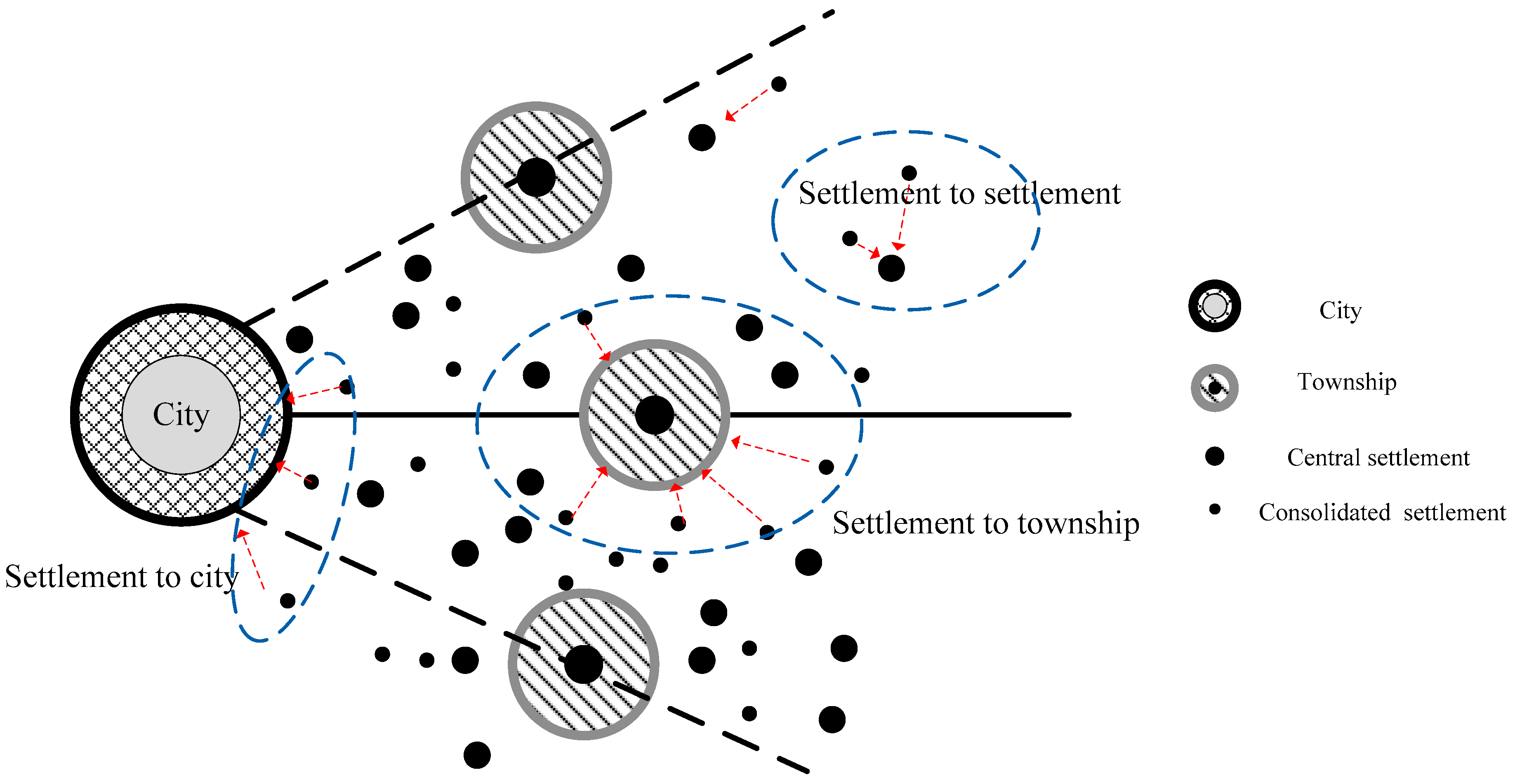
2. Spatial-Territorial Reorganization of Rural Settlements
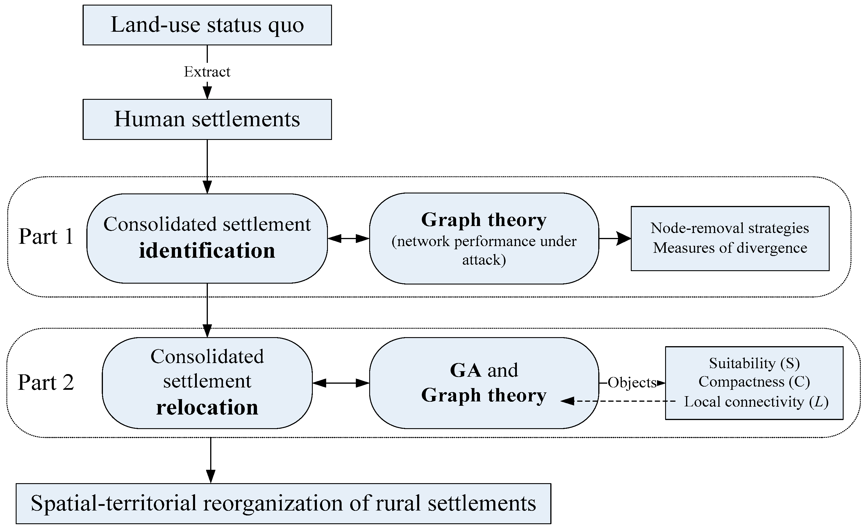
3. Specifications of SRM of Rural Settlements
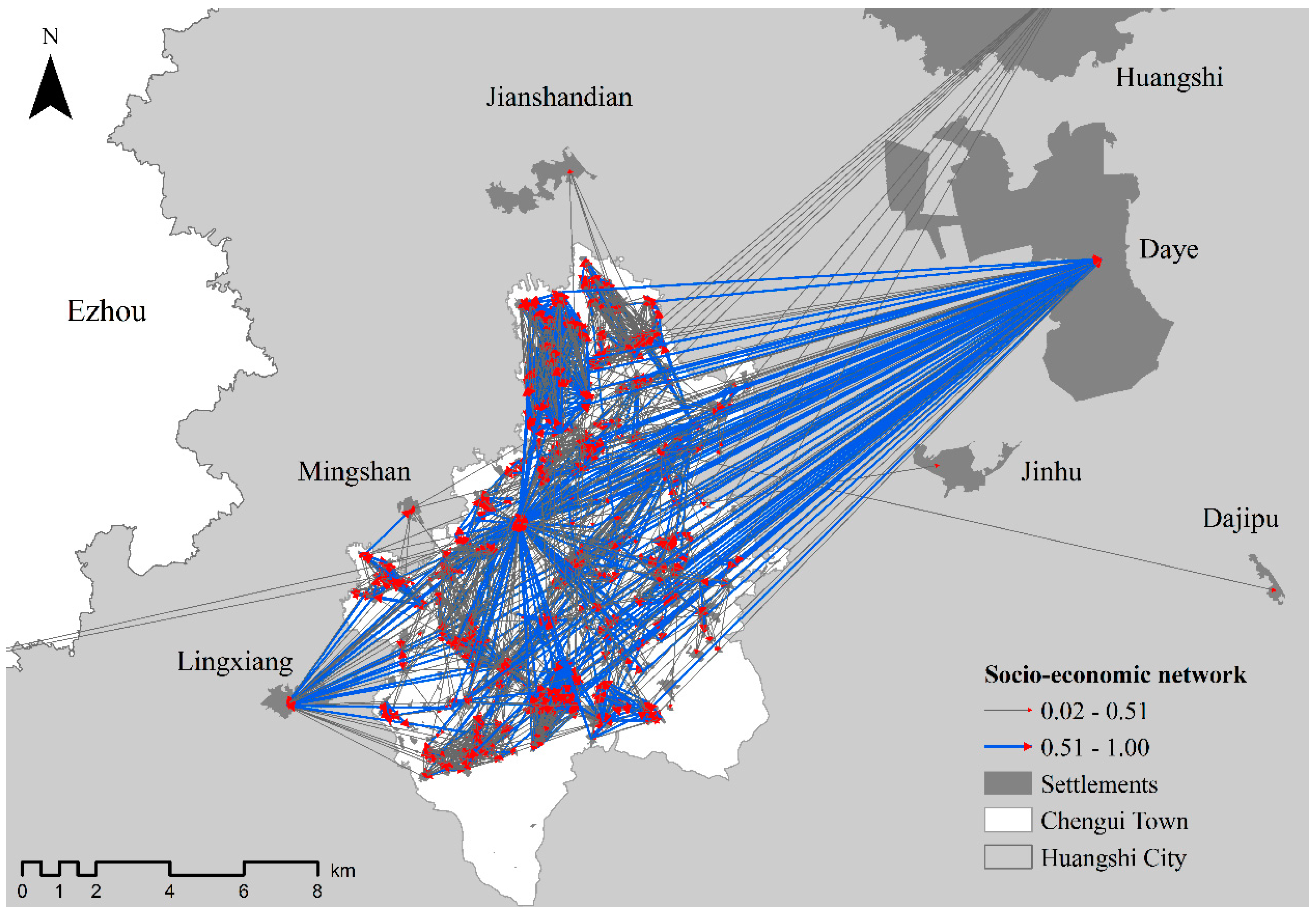
3.1. Consolidated Settlement Identification
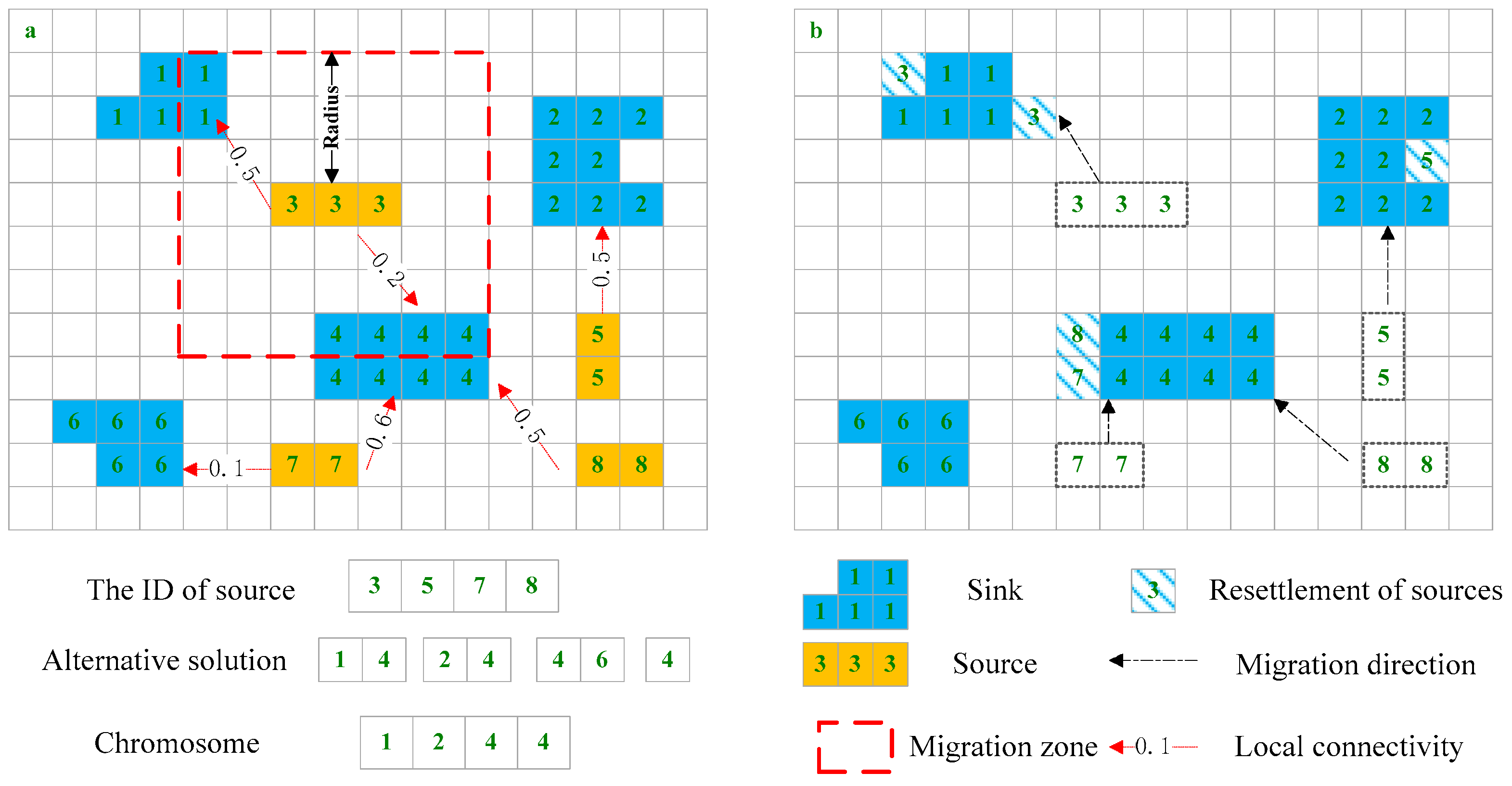
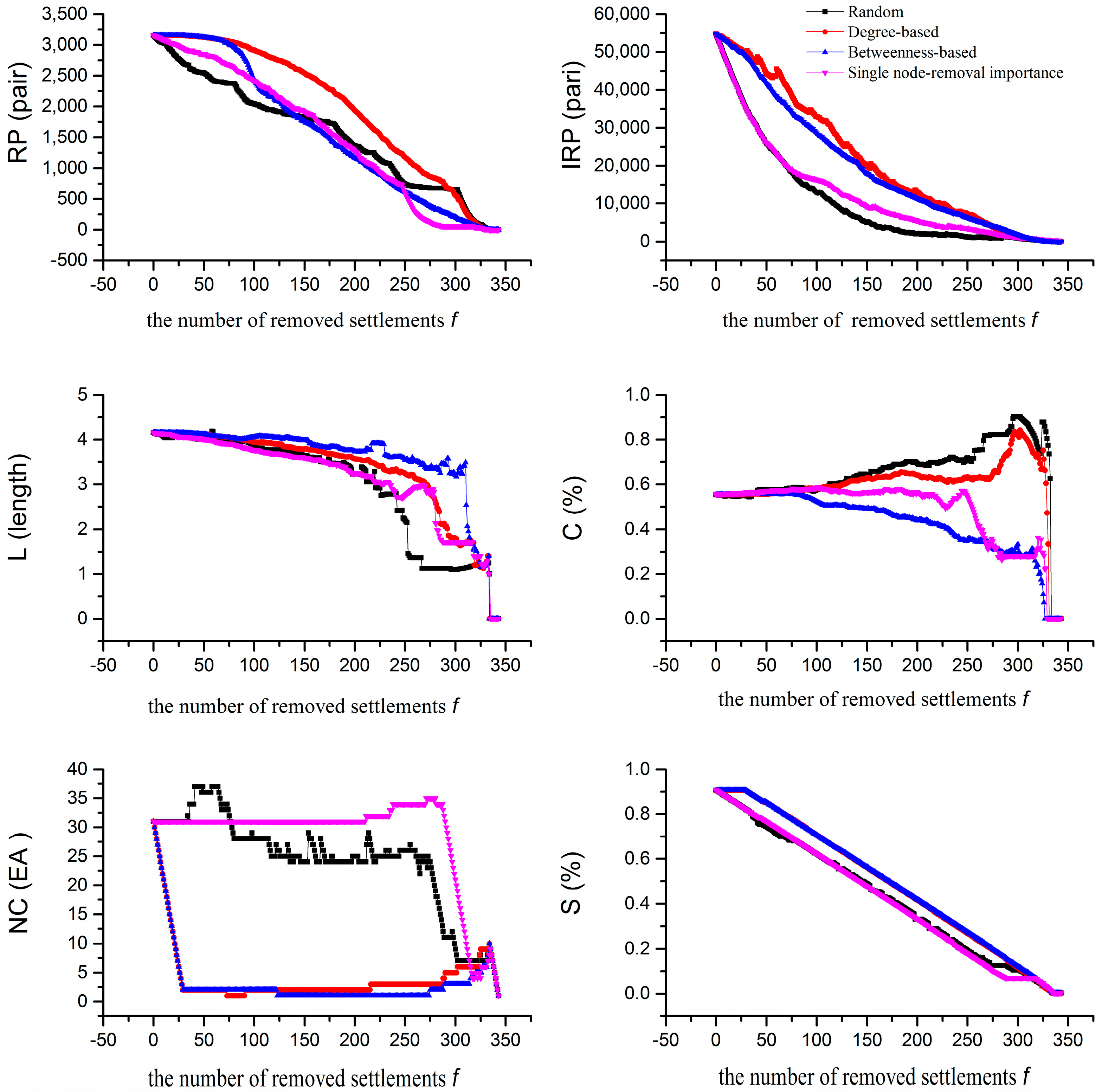
3.1.1. Node-Removal Strategies
3.1.2. Measures of Divergence
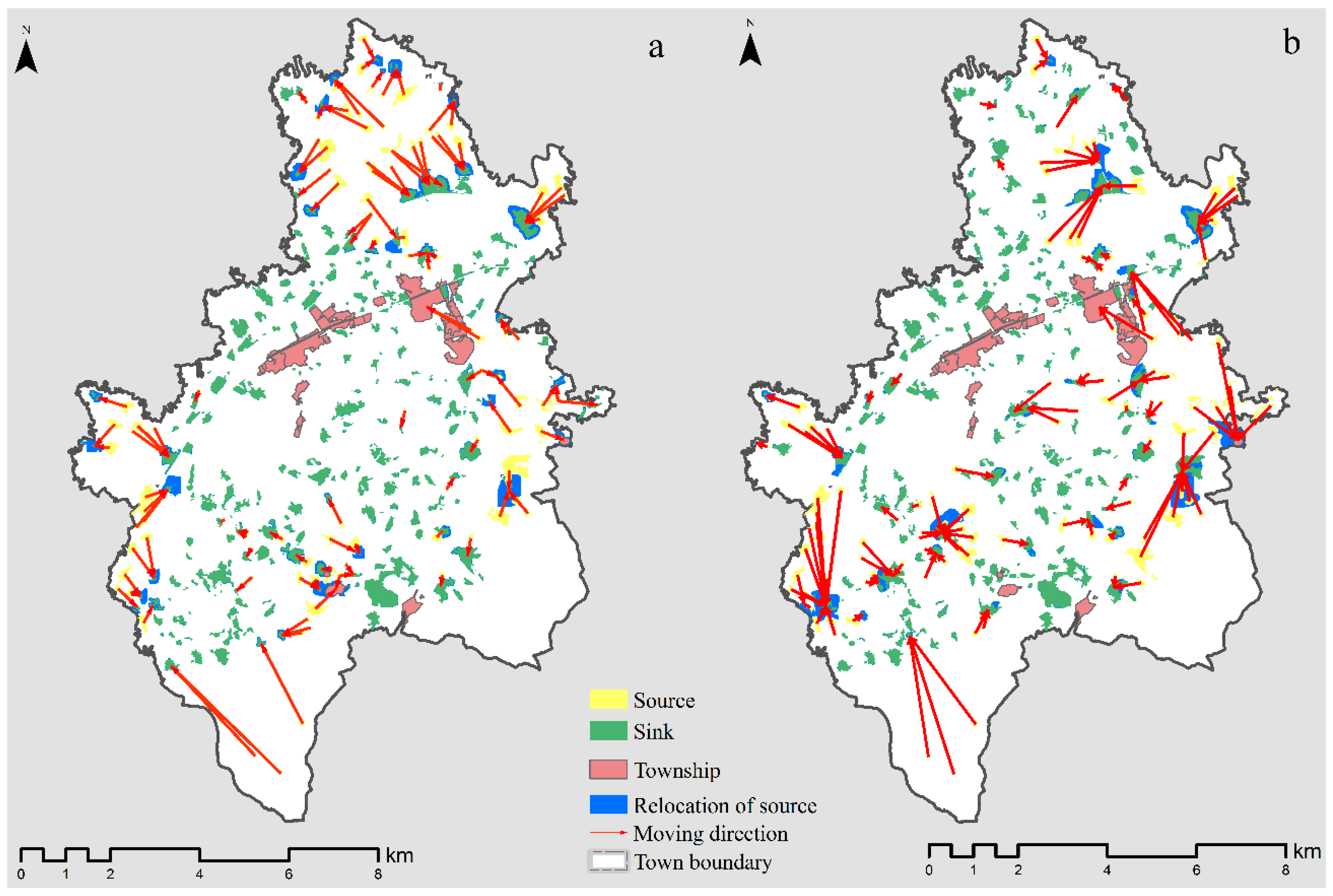
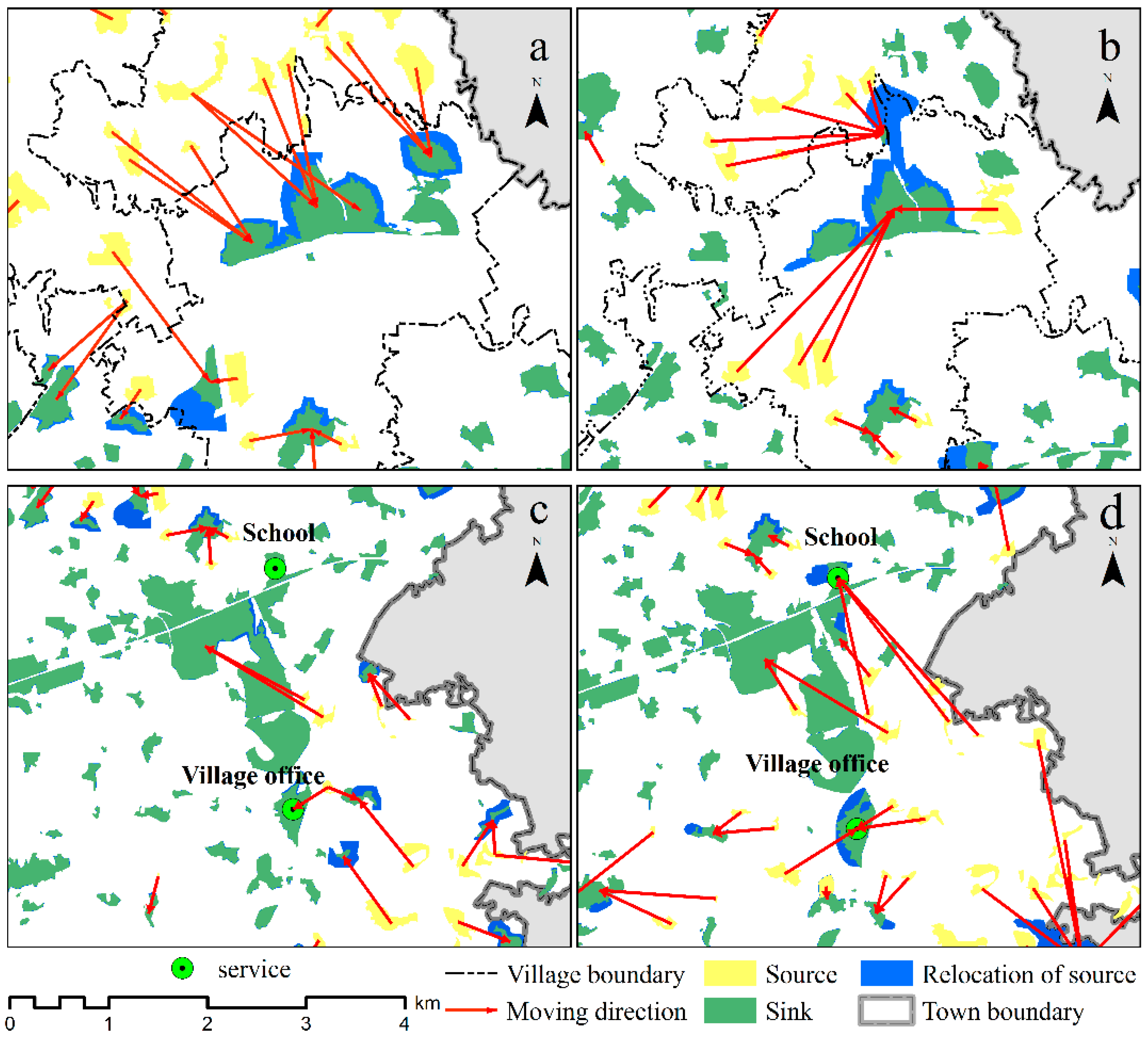
3.2. Consolidated Settlement Relocation
3.2.1. Chromosome Representation
3.2.2. Objectives
3.2.3. Constraints
3.2.4. Genetic Operators
4. Study Area and Data Sources
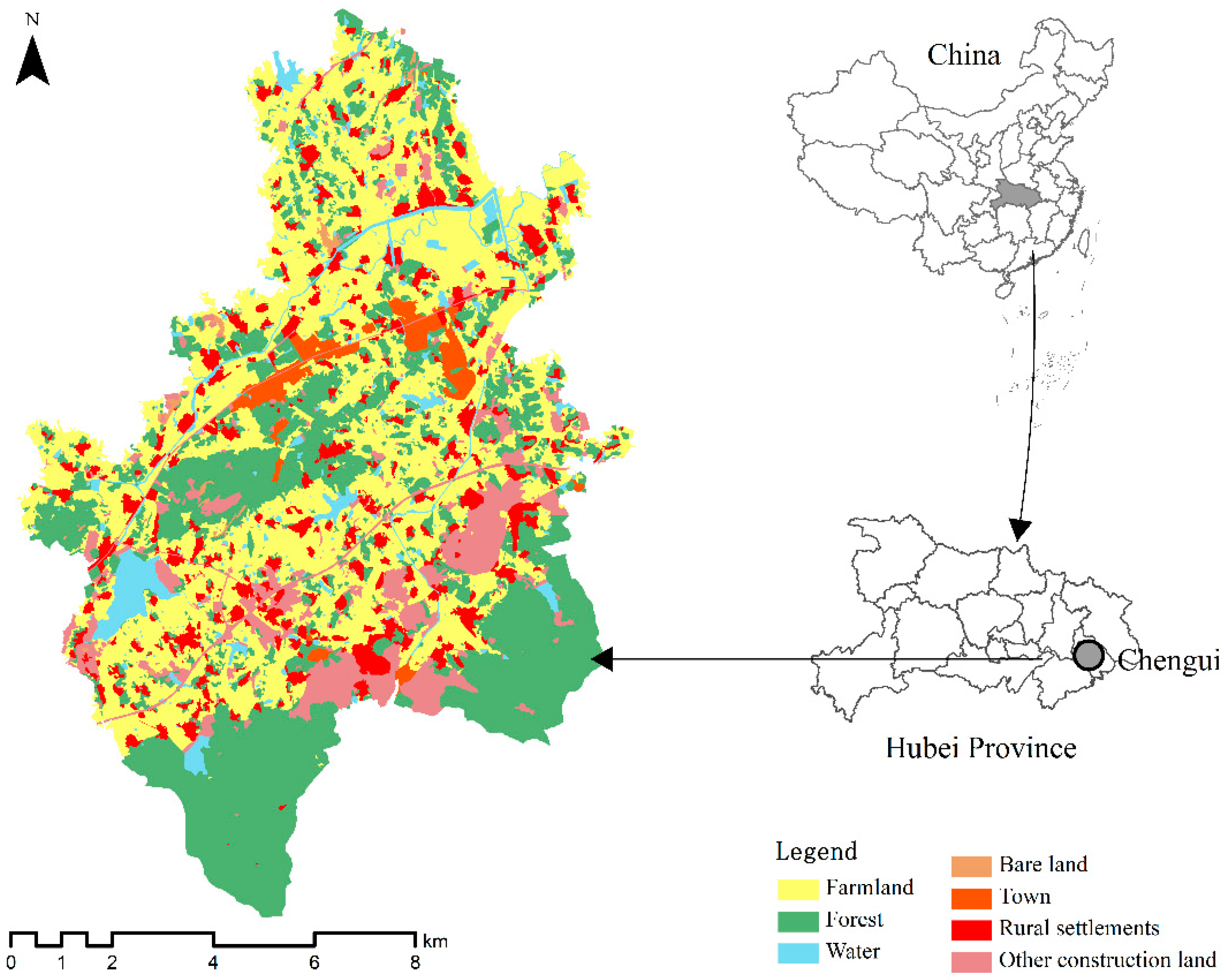
4.1. Study Area
4.2. Data Resources
5. Results and Discussion
5.1. Consolidated Settlement Identification
5.2. Implementation of GA to Relocate Consolidated Settlements
5.3. Relevant Policies/Practices
6. Conclusions and Future Work
Acknowledgments
Author Contributions
Conflicts of Interest
References
- Long, H.L. Land consolidation: An indispensable way of spatial restructuring in rural China. J. Geogr. Sci. 2014, 24, 211–225. [Google Scholar] [CrossRef]
- Long, H.; Liu, Y.; Li, X.; Chen, Y. Building new countryside in China: A geographical perspective. Land Use Policy 2010, 27, 457–470. [Google Scholar] [CrossRef]
- Liu, Y.; Fang, F.; Li, Y. Key issues of land use in China and implications for policy making. Land Use Policy 2014, 40, 6–12. [Google Scholar] [CrossRef]
- Long, H.; Li, Y.; Liu, Y.; Woods, M.; Zou, J. Accelerated restructuring in rural China fueled by ‘increasing vs. Decreasing balance’ land-use policy for dealing with hollowed villages. Land Use Policy 2012, 29, 11–22. [Google Scholar] [CrossRef]
- Liu, Y.; Liu, Y.; Chen, Y.; Long, H. The process and driving forces of rural hollowing in China under rapid urbanization. J. Geogr. Sci. 2010, 20, 876–888. [Google Scholar] [CrossRef]
- Li, Y.R.; Liu, Y.S.; Long, H.L.; Cui, W.G. Community-based rural residential land consolidation and allocation can help to revitalize hollowed villages in traditional agricultural areas of China: Evidence from Dancheng county, Henan province. Land Use Policy 2014, 39, 188–198. [Google Scholar] [CrossRef]
- Zhou, G.H.; He, Y.H.; Tang, C.L.; Yu, T.; Xiao, G.Z.; Zhong, T. Dynamic mechanism and present situation of rural settlement evolution in China. J. Geogr. Sci. 2013, 23, 513–524. [Google Scholar] [CrossRef]
- Entwisle, B.; Faust, K.; Rindfuss, R.R.; Kaneda, T. Networks and contexts: Variation in the structure of social ties. Am. J. Sociol. 2007, 112, 1495–1533. [Google Scholar] [CrossRef]
- Faust, K.; Entwisle, B.; Rindfuss, R.R.; Walsh, S.J.; Sawangdee, Y. Spatial arrangement of social and economic networks among villages in Nang rong district, Thailand. Soc. Netw. 1999, 21, 311–337. [Google Scholar] [CrossRef]
- Zou, Y.; Liu, Y.; Kong, X.; Fan, D. Optimization of rural residential land based on weighted-voronoi diagram. Geomat. Inf. Sci. Wuhan Univ. 2012, 37, 560–563. [Google Scholar]
- Duan, Y.; Lu, F. Robustness of city road networks at different granularities. Phys. A Stat. Mech. Appl. 2014, 411, 21–34. [Google Scholar] [CrossRef]
- Boccaletti, S.; Latora, V.; Moreno, Y.; Chavez, M.; Hwang, D.U. Complex networks: Structure and dynamics. Phys. Rep. 2006, 424, 175–308. [Google Scholar] [CrossRef]
- Albert, R.; Jeong, H.; Barabasi, A.L. Error and attack tolerance of complex networks. Nature 2000, 406, 378–382. [Google Scholar] [CrossRef] [PubMed]
- Boldi, P.; Rosa, M.; Vigna, S. Robustness of social networks: Comparative results based on distance distributions. Soc. Inform. 2011, 6984, 8–21. [Google Scholar]
- Li, X.; Yeh, A.G.O. Integration of genetic algorithms and gis for optimal location search. Int. J. Geogr. Inf. Sci. 2005, 19, 581–601. [Google Scholar] [CrossRef]
- Liu, Y.; Tang, W.; He, J.; Liu, Y.; Ai, T.; Liu, D. A land-use spatial optimization model based on genetic optimization and game theory. Comput. Environ. Urban Syst. 2015, 49, 1–14. [Google Scholar] [CrossRef]
- Stewart, T.J.; Janssen, R.; van Herwijnen, M. A genetic algorithm approach to multiobjective land use planning. Comput. Oper. Res. 2004, 31, 2293–2313. [Google Scholar] [CrossRef]
- Fotakis, D.G.; Sidiropoulos, E.; Myronidis, D.; Ioannou, K. Spatial genetic algorithm for multi-objective forest planning. For. Policy Econ. 2012, 21, 12–19. [Google Scholar] [CrossRef]
- Ducheyne, E.I.; De Wulf, R.R.; De Baets, B. A spatial approach to forest-management optimization: Linking gis and multiple objective genetic algorithms. Int. J. Geogr. Inf. Sci. 2006, 20, 917–928. [Google Scholar] [CrossRef]
- Santé-Riveira, I.; Crecente-Maseda, R.; Miranda-Barrós, D. Gis-based planning support system for rural land-use allocation. Comput. Electron. Agric. 2008, 63, 257–273. [Google Scholar] [CrossRef]
- Aerts, J.C.J.H.; Herwijnen, M.V.; Stewart, T.J. Using simulated annealing and spatial goal programming for solving a multi site land use allocation problem. Lect. Notes Comput. Sci. 2003, 2632, 448–463. [Google Scholar]
- Liu, Y.L.; Wang, H.; Ji, Y.L.; Liu, Z.Q.; Zhao, X. Land use zoning at the county level based on a multi-objective particle swarm optimization algorithm: A case study from yicheng, China. Int. J. Environ. Res. Public Health 2012, 9, 2801–2826. [Google Scholar] [CrossRef] [PubMed]
- Holland, J.H. Adaptation in Natural and Artificial Systems: An Introductory Analysis with Applications to Biology, Control, and Artificial Intelligence; University of Michigan Press: Ann Arbor, MI, USA, 1975. [Google Scholar]
- Goldberg, D.E. Genetic Algorithms in Search, Optimization, and Machine Learning; Addison-Wesley Longman Publishing: Boston, MA, USA, 1989. [Google Scholar]
- Porta, J.; Parapar, J.; Doallo, R.; Rivera, F.F.; Santé, I.; Crecente, R. High performance genetic algorithm for land use planning. Comput. Environ. Urban Syst. 2013, 37, 45–58. [Google Scholar] [CrossRef]
- Cao, K.; Huang, B.; Wang, S.; Lin, H. Sustainable land use optimization using boundary-based fast genetic algorithm. Comput. Environ. Urban Syst. 2012, 36, 257–269. [Google Scholar] [CrossRef]
- Balling, R.J.; Taber, J.T.; Brown, M.R.; Day, K. Multi-objective urban planning using genetic algorithm. J. Urban Plann. Dev. 1999, 125, 86–99. [Google Scholar] [CrossRef]
- Fotakis, D.; Sidiropoulos, E. Combined land-use and water allocation planning. Annu. Oper. Res. 2012, 219, 169–185. [Google Scholar] [CrossRef]
- Boldi, P.; Rosa, M.; Vigna, S. Robustness of social and web graphs to node removal. Soc. Netw. Anal. Min. 2013, 3, 829–842. [Google Scholar] [CrossRef]
- Pereira, M.; Segurado, P.; Neves, N. Using spatial network structure in landscape management and planning: A case study with pond turtles. Landsc. Urban Plan. 2011, 100, 67–76. [Google Scholar] [CrossRef]
- Ding, C.R. Land policy reform in China: Assessment and prospects. Land Use Policy 2003, 20, 109–120. [Google Scholar] [CrossRef]
- Brookes, C.J. A genetic algorithm for locating optimal sites on raster suitability maps. Trans. GIS 1997, 2, 201–212. [Google Scholar] [CrossRef]
- Goldberg, D.E.; Deb, K. A Comparative Analysis of Selection Schemes Used in Genetic Algorithms; Morgan Kaufmann Publishers: San Mateo, CA, USA, 1991. [Google Scholar]
- Yang, R.; Liu, Y.; Long, H.; Qiao, L. Spatio-temporal characteristics of rural settlements and land use in the bohai rim of China. J. Geogr. Sci. 2015, 25, 559–572. [Google Scholar] [CrossRef]
- Kong, X.; Liu, Y.; Zou, Y.; Chen, Y. Calculation of land consolidation potential and optimization of rural residential areas based on households’willingness. Trans. CSAE 2010, 26, 296–301. [Google Scholar]
- Yu, Z. Study on optimization of rural residential land based on weighted-voronoi diagram and calculation of consolidation potential. Guangdong Land Sci. 2013, 12, 43–48. [Google Scholar]
- Adams, J.; Faust, K.; Lovasi, G.S. Capturing context: Integrating spatial and social network analyses. Soc. Netw. 2012, 34, 1–5. [Google Scholar] [CrossRef]
- Hipp, J.R.; Faris, R.W.; Boessen, A. Measuring ‘neighborhood’: Constructing network neighborhoods. Soc. Netw. 2012, 34, 128–140. [Google Scholar] [CrossRef]
- Festinger, L.; Schachter, S.; Back, K. Social Pressures in Informal Groups; Stanford University Press: Palo Alto, CA, USA, 1950. [Google Scholar]
- Barthelemy, M. Spatial networks. Phys. Rep. 2011, 499, 1–101. [Google Scholar] [CrossRef]

| Metrics | Mean | Standard Deviation | Minimum | Median | Maximum |
|---|---|---|---|---|---|
| RP | 3136.01 | 16.10 | 3050.00 | 3139.50 | 3154.00 |
| IRP | 54,440.37 | 335.34 | 54,023.00 | 54,527.00 | 57,743.00 |
| L | 4.16 | 0.02 | 4.11 | 4.15 | 4.34 |
| C | 0.56 | 0.00 | 0.55 | 0.56 | 0.57 |
| NC | 30.97 | 0.49 | 30.00 | 31.00 | 36.00 |
| S | 0.90 | 0.00 | 0.89 | 0.90 | 0.91 |
| Metrics | Random Strategy | Degree-Based Strategy | Betweenness-Based Strategy | Single Node-Removal Importance Strategy |
|---|---|---|---|---|
| RP | 44% | 26% | 51% | 47% |
| IRP | 76% | 41% | 49% | 71% |
| L | 15.87% | 11.58% | 8.06% | 16.38% |
| C | −21.95% | −13.99% | 15.17% | −3.03% |
| Metrics | Traditional Scenario | Optimized Scenario | Positive (+)/Negative(−) |
|---|---|---|---|
| Suitability of source | 3.33 | 3.24 | − |
| Suitability of sink | 4.18 | 4.20 | + |
| Dynamic change degree of source | 0.01 | 0.01 | − |
| The level of hollowing | 0.88 | 0.87 | + |
| Villagers’ receptiveness of consolidation | 0.72 | 0.55 | + |
| RP after attack | 1603 | 2368 | + |
| L after attack | 2.75 | 2.61 | − |
| C after attack | 0.63 | 0.68 | + |
| CN after attack | 132 | 119 | − |
| S after attack | 0.62 | 0.66 | + |
| Population Size | Iteration | Crossover Rate | Mutation Rate | d | α |
|---|---|---|---|---|---|
| 100 | 300 | 0.9 | 0.05 | 1000 | 0.80 |
| Metrics | Traditional Scenario | Optimized Scenario | Positive (+)/Negative(−) |
|---|---|---|---|
| Weight strategy (S/C/L) | 0.5/0.5/0 | 0.3/0.3/0.4 | / |
| Object S | 4.12 | 4.06 | + |
| Object C | 360.60 | 326.85 | − |
| Object C (Mean, C/H) | 1.27 | 1.33 | − |
| Object L | 38.61 | 53.95 | + |
| The moving distance | 674.05 | 844.85 | − |
| NP | 262 | 241 | − |
| PD | 2.34 | 2.16 | − |
| MPS | 4.88 | 5.32 | + |
| MPI | 94.28 | 97.96 | + |
| MNN | 104.25 | 101.93 | − |
| Metrics | Equal Weights Solution | Obj-S Preferred Solution | Obj-C Preferred Solution | Obj-L Preferred Solution |
|---|---|---|---|---|
| Weight strategy (S/C/L) | 0.5/0.5/0 | 1/0/0 | 0/1/0 | 0/0/1 |
| Object S | 4.06 | 4.06 | 4.06 | 4.06 |
| Object C | 325.38 | 329.27 | 324.75 | 326.81 |
| Object C (Mean, C/H) | 1.33 | 1.34 | 1.33 | 1.34 |
| Object L | 38.01 | 37.15 | 37.01 | 59.24 |
| The moving distance | 691.23 | 686.74 | 693.83 | 860.55 |
| NP | 239 | 240 | 239 | 238 |
| PD | 2.15 | 2.15 | 2.15 | 2.14 |
| MPS | 5.36 | 5.34 | 5.38 | 5.34 |
| MPI | 96.48 | 97.25 | 97.98 | 96.73 |
| MNN | 102.56 | 101.90 | 102.05 | 102.35 |
© 2017 by the authors. Licensee MDPI, Basel, Switzerland. This article is an open access article distributed under the terms and conditions of the Creative Commons Attribution (CC BY) license (http://creativecommons.org/licenses/by/4.0/).
Share and Cite
Mao, Y.; Liu, Y.; Wang, H.; Tang, W.; Kong, X. A Spatial-Territorial Reorganization Model of Rural Settlements Based on Graph Theory and Genetic Optimization. Sustainability 2017, 9, 1370. https://doi.org/10.3390/su9081370
Mao Y, Liu Y, Wang H, Tang W, Kong X. A Spatial-Territorial Reorganization Model of Rural Settlements Based on Graph Theory and Genetic Optimization. Sustainability. 2017; 9(8):1370. https://doi.org/10.3390/su9081370
Chicago/Turabian StyleMao, Yan, Yanfang Liu, Haofeng Wang, Wei Tang, and Xuesong Kong. 2017. "A Spatial-Territorial Reorganization Model of Rural Settlements Based on Graph Theory and Genetic Optimization" Sustainability 9, no. 8: 1370. https://doi.org/10.3390/su9081370
APA StyleMao, Y., Liu, Y., Wang, H., Tang, W., & Kong, X. (2017). A Spatial-Territorial Reorganization Model of Rural Settlements Based on Graph Theory and Genetic Optimization. Sustainability, 9(8), 1370. https://doi.org/10.3390/su9081370