1. Introduction
Mountains cover approximately 70% of South Korea with the exception of low-lying plains in the western areas. Countries with mountainous terrain such as South Korea, Japan, China, Turkey, Italy, Spain, India, and the USA have tried various techniques and methods to stabilize a slope devastated by road development and urban construction [
1]. One of them represents a biotechnical engineering technique in which vegetation is integrated with inert structures such as concrete blocks [
2], and is applied in projects such as slope stabilization. Biotechnical stabilization employs the reciprocal mechanics of soil and biological elements—mostly plants—to prevent slope erosion and failure [
3]. Such techniques have spread out across China, Japan, Spain, Italy, and the USA [
4,
5,
6,
7,
8].
Slope revegetation, which is a common method of biotechnical stabilization, has positive effects on slope stability, and facilitates successful restoration when accompanied by appropriate understanding of environmental limitations [
2,
9,
10]. Slope revegetation works have been widely implemented on large and steep slopes in temperate zones [
6,
11,
12]. However, revegetated slopes frequently fail due to heavy rain and drought [
13]. The reasons for failure include the elimination of seeds by water running over uncovered and crusted soils and withered plants due to the inappropriate use of commercial species without the consideration of neighboring environments and due to extreme changes in local climate, such as intermittent dry seasons and heavy rainfall [
14,
15]. Revegetated slopes in Korea have also undergone soil erosion and failure.
Previous studies were indirectly relevant to the issue of stabilization of revegetated slopes. The method of evaluation for slope revegetation has mainly focused on establishing vegetation [
16,
17], and on numerical modeling of the interactive relationships between erosion and vegetation [
18,
19,
20]. Such studies required long-term monitoring and numerical analysis. Moreover, other studies employed discrimination analysis of slope stability of a natural cut-slope and a slope without revegetation [
21], interpretation of vegetation distribution on revegetated slopes [
22,
23], and interpretation and standardization of partial properties of soil and vegetation [
17,
24,
25,
26,
27,
28]. The use of partial variables of revegetated slopes does not facilitate an overall perspective of stability. Stability assessment via integrated variables encompassing a wide range related to slope stabilization has been required.
The present study compares stable slopes with those at risk of slope failure or erosion via correlation analysis and non-parametric tests on field survey data collected from revegetated cut-slopes.
2. Methods
2.1. Study Sites
The province of Gangwon-do, Korea, was chosen for several reasons. Gangwon-do is categorized as 81.7% mountainous terrain, in which mostly bedrock comprises a granite rock layer (website of Gangwon-do Provincial Office). The slopes in Gangwon-do are at high risk of landslides [
29,
30]. In addition, most disastrous events related to steep slopes that were investigated in Korea from 1999 to 2011 occurred in Gangwon-do [
31]. Stabilizing revegetation can be difficult in failure-prone slopes.
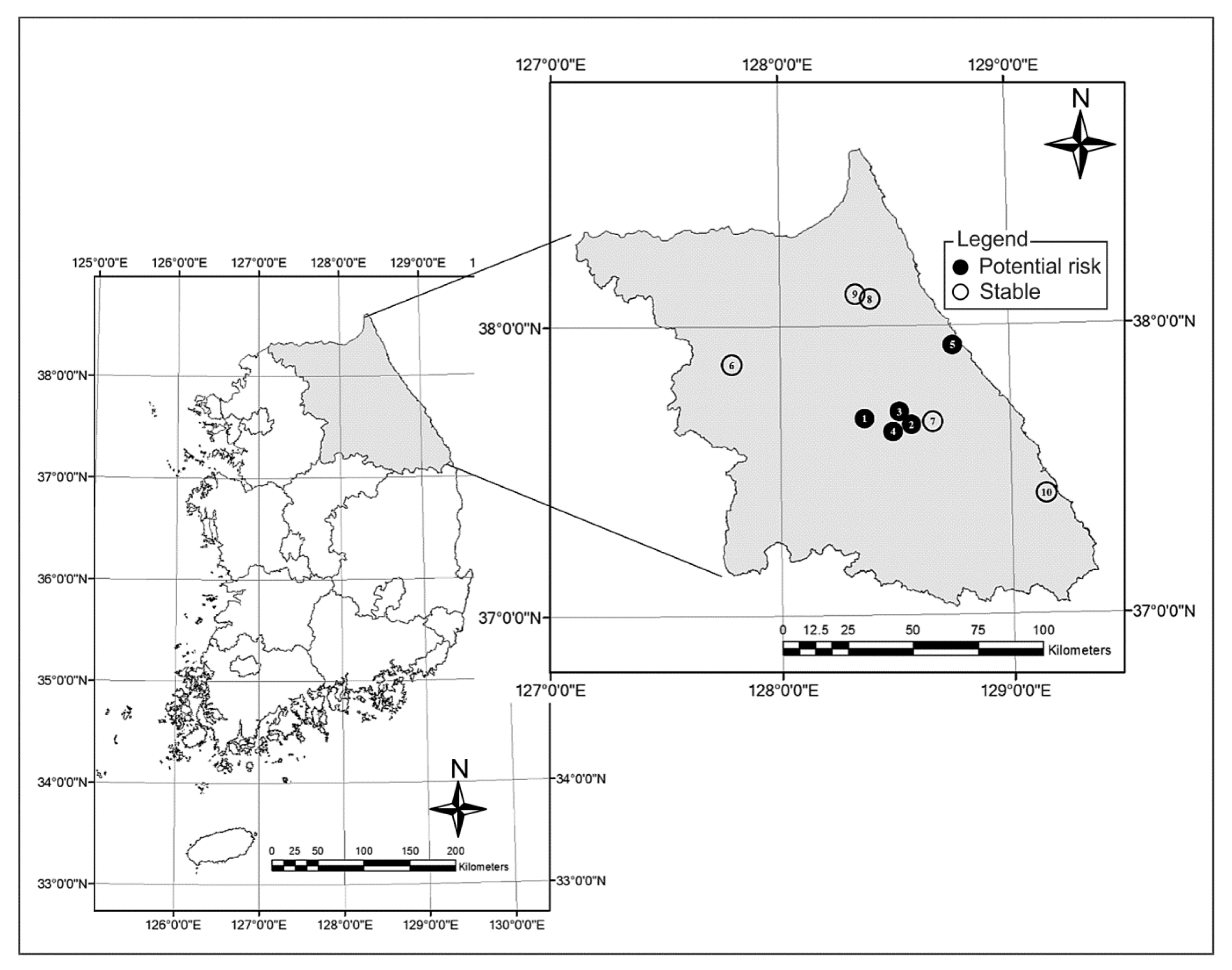
Ten revegetated slopes were selected, which were classified as test or control sites (
Figure 1). The five test sites consisted of slopes that appeared to be potentially unstable due to neighboring slope failure, as identified by visual inspection during a field survey in Gangwon-do during 2012. The control sites were known as construction methods with five stable slopes and date of slope revegetation in Gangwon-do, surveyed during 2012. The general warranty period in Korea has been required to manage vegetation establishment and survey slope erosion or failure for two years after revegetation. Even slopes revegetated for two years can show symptoms of failure after the two-year warranty period. Such slopes can be unstable. On the other hand, most revegetated slopes including various vegetation without symptoms of failure or erosion after the two-year warranty period can be typically guaranteed as stable sites in Korea. All of the study sites passed the warranty period of two years of elapsed time since slope revegetation work (ranging from three to nine years).
Figure 1.
Locations of revegetated slopes in Korea: categorized as stable or potentially unstable with slope failure.
Figure 1.
Locations of revegetated slopes in Korea: categorized as stable or potentially unstable with slope failure.
2.2. Selection of Variables
Consideration of all the variables gathered from previous studies was not effective because certain variables were inadequate to explain slope failure or had a minor effect on other variables. Representative variables that were highly correlated could be more effective for evaluating slope stabilization. Additionally, explaining a large number of variables would be too costly and resource-intensive. Measurement variables supported by [
32] were selected for relevance to failure and soil erosion, and these included slope stability analysis, landslide analysis, and slope revegetation, as shown in
Table 1.
Table 1.
Variables used in this study.
Table 1.
Variables used in this study.
| Category | Major Variables |
|---|
| Physical characteristics | Slope angle, Slope height, Slope type, Slope width, Aspect, Drainage system, Time since revegetation (years), Ground layer, Seepage water |
| Vegetation | Number of tree species by nomenclature, Number of herb species by nomenclature, Vegetation coverage, Plant community (tree species by nomenclature) |
| Soil | Soil depth, Porosity, Soil acidity, Soil hardness, Water content, Soil texture, Permeability coefficient, Tensile strength, Organic matter, Salt concentration |
2.3 Data Collection
A field survey was conducted twice, first from 15 September to 19 October 2012, and second from 21 to 23 June 2013. The second survey was conducted to collect supplementary data for the width and length of a slope. The field survey was conducted on both failure slopes and stable slopes. The survey methods for each variable are summarized in
Table 2.
Table 2.
Method of measurement for each variable.
Table 2.
Method of measurement for each variable.
| Variables | Method | Reference |
|---|
| Physical characteristics | Slope angle (°) | | Woo et al. (1996) [22] |
| Aspect (-) | SILVA RANGER compass Classification: north-northeast (N-NE), east-northeast (E-NE), east-southeast (E-SE), south-southeast (S-SE), south-southwest (S-SW), west-southwest (W-SW), west-northwest (W-NW), north-northwest (N-NW)
| Jeon et al. (2003) [21] |
| Slope width (m) | | Woo et al. (1996) [22] |
| Slope height (m) | | Woo et al. (1996) [22] |
| Slope type (no.) | | Jeon et al. (2003) [21] |
| Ground layer (no.) | | * KCPA (2012) [33] |
| Seepage water (no.) | | ** NEMA (2010) [34] |
| Elapsed year (no.) | | Jeon et al. (2003), [21] Im and Ma (1999) [35] |
| Drainage system (no.) | Determine whether a revegetated site followed an act, regulation, or notification of drain facilities provided by the government: Not applied (0), Applied (1)
| NEMA (2010) [34], *** MOLIT (2009) [36] |
| Vegetation | Plant community (no.) | Classification: Single heterogeneous layer (1), Single homogeneous layer (2), Multiple heterogeneous layer (3), Multiple homogeneous layer (4) Single heterogeneous layer: a simple layer landscape including either tall trees or shrubs, and an ecologically poor community structure, differing from adjacent environments Single homogenous layer: a simple layer landscape including either tall trees or shrubs, and planting equivalent tree species in harmony with close environments Multiple heterogeneous layer: multi-layered landscape including tall trees, medium-height trees and shrubs, and an ecologically poor community structure, differing from adjacent environments Multiple homogeneous layer: multi-layered landscape including tall trees, medium-height trees and shrubs, and an ecologically superior community structure in harmony with close environments
| Lee et al. (2012) [37] |
| Vegetation coverage (%) | | Bochet and Garcia-Fayos (2004) [13], MOLIT (2009) [36] |
| Number of tree species (no.) | Quadrat method (5 m × 5 m), measured three times at each site Number of tree species by plant nomenclature
| Bochet and Garcia-Fayos (2004) [13], MOLIT (2009) [36] |
| Number of herb species (no.) | Quadrat method (5 m × 5 m), measured three times at each site Number of tree species by plant nomenclature
| Bochet and Garcia-Fayos (2004) [13], MOLIT (2009) [36] |
| Soil | Porosity (%) | Calculation by values of bulk density and particle density Bulk density: a variable of soil compaction. Measured as the dry weight of soil divided by its volume (**** USDA, 2008) Particle density: the weight of a soil particle per unit volume
| Brady and Weil (2007) [38] |
| Soil hardness (mm) | | Woo et al. (1996) [22] |
| Water content (m3/ m3) | | Gardner (1968) [39] |
| Soil texture (%) | | Shirazi and Boersma (1984) [40] |
| Tensile strength (kPa) | | Nearing et al. (1988) [41] |
| Permeability coefficient (cm/s) | Calculation by constant head method using the flux per hour, length of soil column, and hydraulic head, in accordance with Darcy’s law
| Hillel (1972) [42] |
| Soil depth (cm) | | MOLIT (2009) [36] |
| Soil acidity (pH) | | Rayment and Higginson (1992) [43] |
| Salt concentration (%) | Conversion by electrical conductivity (EC), measured using a 1:5 solution of soil:water Electrical conductivity (ds/m) using the formula: 1 ds/m = 1 ms/cm = 1 mmho/cm = 640 ppm = 640 mg/L = 0.64 g/L = 0.064%
| Rayment and Higginson (1992) [43] |
| Organic matter (%) | | Walkley and Black (1934) [44] |
Most of the slope failures following revegetation occurred on a partial and sporadic basis rather than involving an entire slope. The standard selecting failure spots reflected suggestions of MOLIT (2009) [
36] and experts who have over a 10-year career in the field of slope revegetation. They were condition of rudimentary plants, composition of simple species, appearance of low viscosity checked by hand-rubbing of revegetated soils and easily shattering them, and non-establishment of wire mesh or fiber net in spite of a steep slope over 45 degrees even if the warranty period is over two years. Such failure spots were deemed to have a high possibility of failure in the near future. A revegetated spot located directly adjacent to a plainly visible failure spot can be understood as a “potential unstable” spot to investigate the reason of failure.
It is worthwhile to compare the variables for “potential unstable” sites with those of stable slopes, since the potential failure sites retain soil and vegetation appearance comparable to stable slopes; this differs from the plainly visible failure spots, which show only exposed soil.
In the soil-sampling method, two steps were followed as disturbed sampling. The first step involved taking soil from the slope surface using a stainless steel can (volume 100 cc) and a trowel in order to examine soil water content and porosity. The trowel was used to gather soil samples of approximately 500 g to examine the other variables. The second step involved determining the location from which to take soil, categorized as a potential unstable spot or stable spot. The potential unstable spots were adjacent to failure spots. The stable spots were locations that had not collapsed following slope revegetation. Three soil samples were obtained from each spot.
The three samples from each site were used to calculate average values for slope angle, physical characteristics, vegetation variables, and soil variables. The data were measured via nominal scales and converted to a ratio scale. Data are commonly normalized to facilitate the statistical analysis of quantitative data originally recorded in differing nominal and ordinal scales. Each variable that satisfied a significant level and showed a high correlation coefficient was discussed in relation to previous studies.
The difference in each variable between potential unstable and stable slopes was also analyzed using the Mann-Whitney U-test (Umw) for non-parametric testing. A variable showing a significant difference could be used to differentiate between the two groups. Otherwise, the variable would not explain the classification for the two groups. The test results for each variable are assessed in relation to previous studies.
For non-parametric testing, most data also used average values for each site, except for soil and vegetation data. Since the soil and vegetation data were independently collected in triplicate within the same site, the raw soil data were used for the analysis. Statistical analysis used SPSS 21.0.
3. Results
3.1. Physical Characteristics
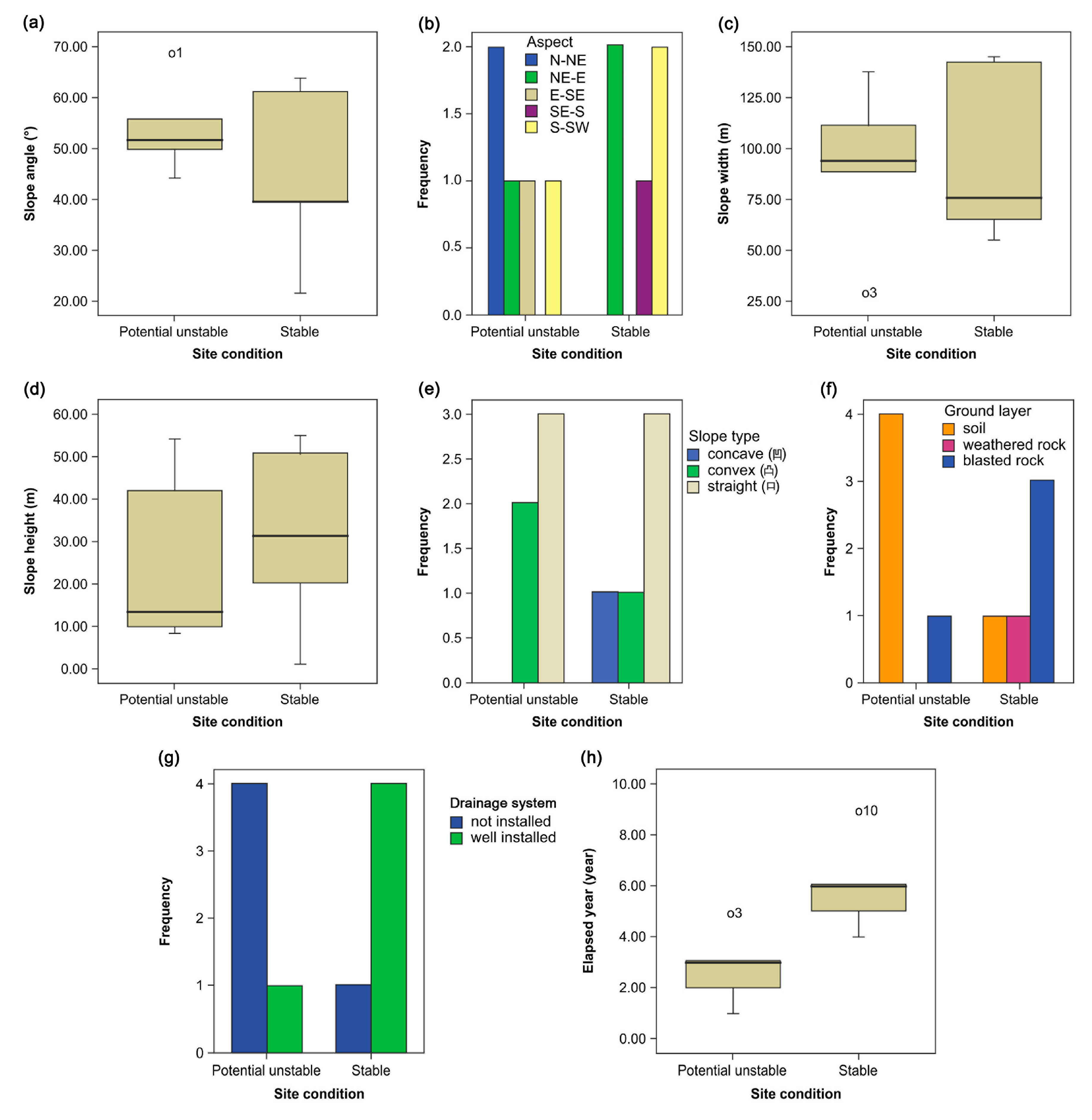
The slope angle was greater than 45° at most sites. The average slope angle was steeper on potential unstable slopes than on stable slopes. In terms of aspect, the potential unstable slopes included one oriented south-southwest, one east-northeast, one east-southeast, and two north-northeast. The stable slopes included two oriented south-southwest, two east-northeast, and one south-southeast (
Figure 2).
Potential unstable slopes had higher average values than stable slopes in the distribution of slope angle (
Umw = 7.5;
p > 0.05,
Figure 2a) whereas they had lower average values in slope height (
Umw = 12;
p > 0.05,
Figure 2c), slope width (
Umw = 10;
p > 0.05,
Figure 2d), and elapsed year (
Umw = 12.5;
p > 0.05,
Figure 2h). The aspects of potential unstable slopes were mostly northeast-oriented whereas stable slopes were east-oriented (
Umw = 7;
p > 0.05,
Figure 2b). Straight slope type was predominant in both slopes (
Umw = 11.5;
p > 0.05,
Figure 2e). The ground layers of most potential unstable slopes were soil, while most stable slopes were blasted rock (
Umw = 5.5;
p > 0.05,
Figure 2f). Drainage systems were not installed in most of the potential unstable slopes (
Umw = 5;
p > 0.05,
Figure 2g). No traces of seepage were found in both slopes (
Umw = 12.5;
p > 0.05). In summary, except for the ground layer, most variables of physical characteristics were not statistically different between potential unstable slopes and stable slopes.
Figure 2.
Physical characteristics of potential unstable slopes and stable slopes. (a) Distribution of slope angle; (b) Frequency of aspect; (c) Distribution of slope width; (d) Distribution of slope height; (e) Frequency of slope type; (f) Frequency of ground layer; (g) Frequency of drainage system; (h) Distribution of elapsed year.
The slope width of the potential unstable slopes ranged from 29.7 m to 138 m (average 92.02 m), and the stable slopes ranged from 55 m to 145.4 m (average 96.78 m). The height of potential unstable slopes ranged from 8.2 m to 54 m (average 25.5 m), and that of stable slopes ranged from 1.1 m to 50.5 m (average 31.54 m). Slope type was classified as convex, concave, or straight. The potential unstable slopes consisted of three straight and two convex slopes, and the stable slopes consisted of three straight, one convex, and one concave slope.
The ground layer was classified as soil, weathered rock, or blasted rock. Potential unstable slopes consisted of four soils and one blasted rock, and stable slopes consisted of one soil, one weathered rock, and three blasted rock.
Traces of seepage were investigated to determine whether there was a correlation between water condition and slope failure; however, no traces were found and all slopes were completely dry. Most potential unstable slopes had been revegetated more than two years previously, but no seepage was traced, indicating that other factors had led to their failure. Seepage flow often ensues when the pores between soils or the hole of a crack in the bedrock become saturated with water and intersect a restrictive layer, which is any soil stratum or layer, including unfractured bedrock, that restricts the vertical movement of water [
25].
The elapsed time since previous revegetation of the potential unstable slopes ranged from one to five years, and that of the stable slopes ranged from four to nine years. Slope failure or erosion did not occur in places where drainage facilities were well installed.
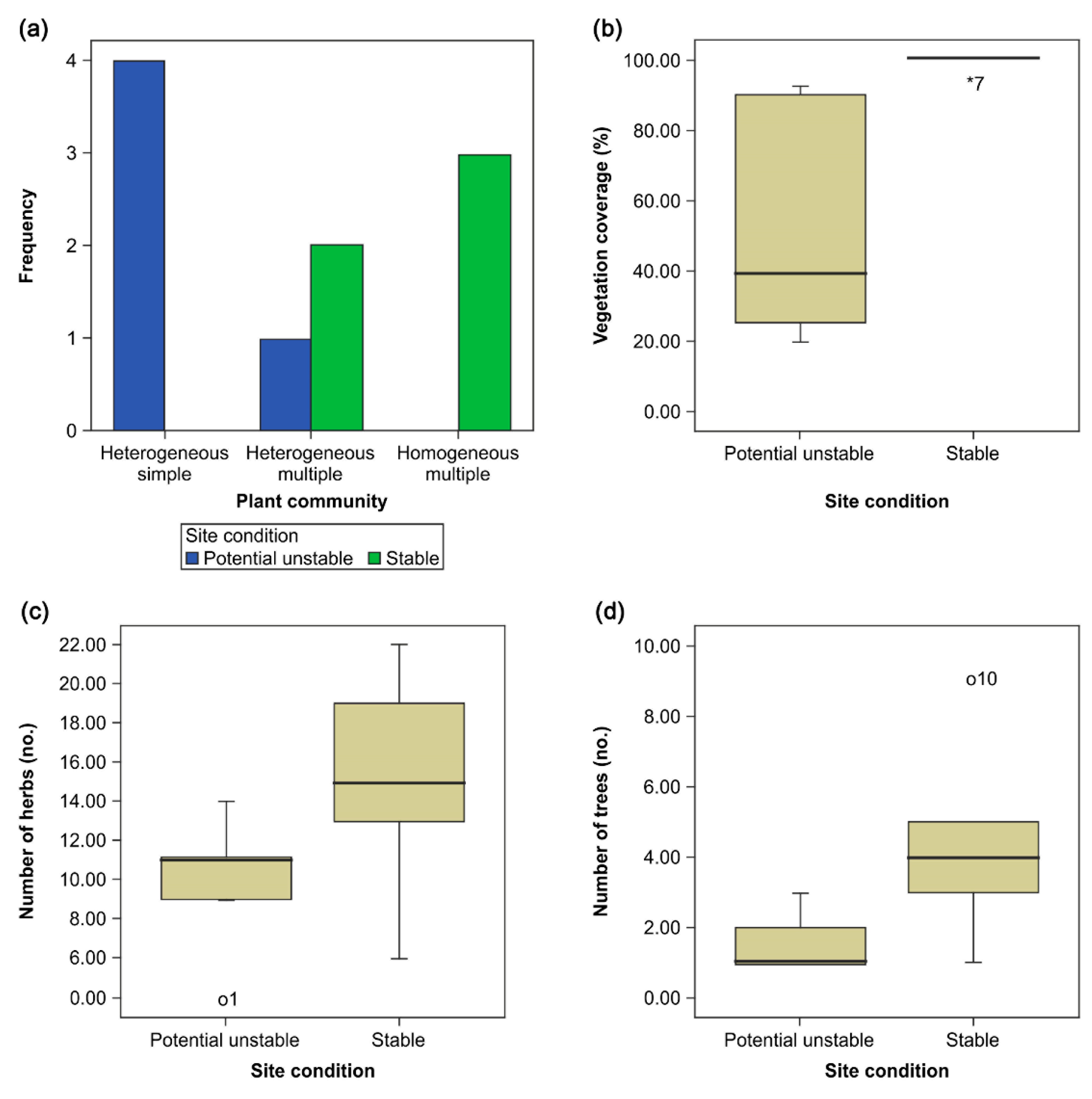
3.2. Vegetation Properties
All types of plant communities on the potential unstable slopes were heterogeneous. Most vegetative layers on the potential unstable slopes were simple. On the stable slopes, homogeneous multiple layers were predominant. Vegetation coverage ranged from 15% to 92.67% on the potential unstable slopes, and from 93.67% to 99.67% on the stable slopes (
Figure 3).
Plant communities of potential unstable slopes were all heterogeneous and had a simple layer (
Umw = 15;
p < 0.05,
Figure 3a). Potential unstable slopes had lower average values than stable slopes in the distribution of vegetation coverage (
Umw = 6;
p < 0.05,
Figure 3b), number of herb species (
Umw = 49.5;
p < 0.05,
Figure 3c), and number of tree species (
Umw = 34.5;
p < 0.05,
Figure 3d). All vegetation properties were significantly different between potential unstable slopes and stable slopes.
Figure 3.
Vegetation properties of potential unstable slopes and stable slopes. (a) Frequency of plant community; (b) Distribution of vegetation coverage; (c) Distribution of number of herb species; (d) Distribution of number of tree species.
Figure 3.
Vegetation properties of potential unstable slopes and stable slopes. (a) Frequency of plant community; (b) Distribution of vegetation coverage; (c) Distribution of number of herb species; (d) Distribution of number of tree species.
Fifteen species of trees were observed in total, with one to four species on potential unstable slopes, compared with two to ten species on stable slopes. Short-stalked bush clover (
Lespedeza cyrtobotrya) was present on seven slopes. Indigo plants (
Indigofera pseudotinctoria) were present on five slopes. False acacia (
Robinia pseudoacacia), silk trees (
Albizia julibrissin), and Manchurian alder (
Alnus sibirica) were each present on four slopes (
Table 3).
Table 3.
Trees at each site.
Table 3.
Trees at each site.
| Category | Number of Tree Species | Botanical Name |
|---|
| 1 | Potential risk | 1 | Lespedeza cyrtobotrya |
| 2 | Potential risk | 3 | Lespedeza cyrtobotrya, Rubus crataegifolius Bunge, Indigofera pseudotinctoria |
| 3 | Potential risk | 4 | Indigofera pseudotinctoria, Rubus crataegifolius Bunge, Robinia pseudoacacia, Lespedeza cyrtobotrya |
| 4 | Potential risk | 1 | Robinia pseudoacacia |
| 5 | Potential risk | 1 | Lespedeza cyrtobotrya |
| 6 | Stable | 4 | Clerodendrum trichotomum, Prunus sargentii, Lespedeza cyrtobotrya, Robinia pseudoacacia |
| 7 | Stable | 6 | Rhus chinensis, Albizzia julibrissin, Firmiana simplex, Salix koreensis Andersson, Indigofera pseudotinctoria, Alnus sibiroca |
| 8 | Stable | 2 | Albizzia julibrissin, Alnus sibiroca |
| 9 | Stable | 4 | Albizzia julibrissin, Quercus mongolica, Lespedeza cyrtobotrya, Indigofera pseudotinctoria |
| 10 | Stable | 10 | Albizzia julibrissin, Ailanthus altissima, Alnus sibiroca, Morus bombycis, Alnus sibiroca, Lespedeza cyrtobotrya, Indigofera pseudotinctoria, Zanthoxylum piperitum, Rubus crataegifolius Bunge, Robinia pseudoacacia |
A total of 59 herb species, small flowering plants, and grasses were observed. There were four to 14 species on the potential unstable slopes and six to 22 species on the stable slopes. The species mugwort (
Artemisia princeps var.
orientalis), common meadow-grass (
Poa pratensis), Japanese hop
(Humulus japonicus), jewelweed (
Impatiens textori), yomena herb (
Aster yomena), wild chrysanthemum (
Dendranthema boreale (Makino) Ling
ex Kitam), and daisy fleabane (
Erigeron annuus) were each present on more than five slopes (
Table 4).
Table 4.
Herbs at each site.
Table 4.
Herbs at each site.
| Category | Number of Herb Species | Botanical Name |
|---|
| 1 | Potential risk | 4 | Poa pratensis, Humulus japonicus, Artemisia feddei Lev. et Van., Arundinella hirta |
| 2 | Potential risk | 11 | Aster yomena, Poa pratensis, Persicaria hydropiper, Miscanthus sinensis var. purpurascens, Crepidiastrum sonchifolium, Dendranthema boreale, Metaplexis japonica, Artemisia montana Pampan, Picris hieracioides var. glabrescens, Commelina communis, Solidago virga-aurea var. asiatica |
| 3 | Potential risk | 11 | Chelidonium majus var. asiaticum, Inula britannica var. chinensis, Poa pratensis, Clematis apiifolia, Commelina communis, Humulus japonicus, Impatiens textori, Erigeron annuus, Aster yomena, Dendranthema boreale |
| 4 | Potential risk | 14 | Artemisia princeps var. orientalis, Centaurea cyanus, Aster yomena, Coreopsis drummondii, Coreopsis tinctoria, Silene armeria, Crepidiastrum sonchifolium, Callistephus chinensis, Humulus japonicus, Medicago sativa, Cosmos bipinnatus, Dianthus superbus var. longicalycinus, Impatiens textori, Persicaria hydropiper |
| 5 | Potential risk | 9 | Cosmos bipinnatus, Trifolium repens, Artemisia princeps var. orientalis, Dendranthema boreale, Silene armeria, Dianthus superbus var. longicalycinus, Chenopodium album var. centrorubrum, Setaria viridis |
| 6 | Stable | 19 | Angelica decursiva, Aconitum pseudo-proliferum, Aster ageratoides Turcz. var. ageratoides, Peucedanum terebinthaceum, Crepidiastrum denticulatum, Artemisia princeps var. orientalis, Chenopodium album var. centrorubrum, Potentilla fragarioides var. major, Poa pratensis, Impatiens textori, Erigeron annuus, Persicaria hydropiper, Trifolium repens, Pteridium aquilinum var. latiusculum, Chenopodium ficifolium, Commelina communis, Humulus japonicus, Oenothera biennis, Pilea mongolica |
| 7 | Stable | 13 | Coreopsis drummondii, Lotus corniculatus var. japonicus, Poa pratensis, Echinacea angustifolia, Aster yomena, Dianthus superbus var. longicalycinus, Arundinella hirta, Rubia akane, Geranium sibiricum, Chelidonium majus var. asiaticum, Setaria viridis, Artemisia princeps var. orientalis, Erigeron annuus |
| 8 | Stable | 15 | Artemisia princeps var. orientalis, Lactuca indica var. laciniata, Dendranthema boreale, Impatiens textori, Taraxacum officinale, Prunella vulgaris Linne var. lilacina Nakai, Phragmites communis, Arundinella hirta, Rumex crispus L., Peucedanum terebinthaceum, Humulus japonicus, Coreopsis tinctoria, Silene armeria, Lotus corniculatus var. japonicus |
| 9 | Stable | 6 | Artemisia princeps var. orientalis, Miscanthus sinensis var. purpurascens, Lotus corniculatus var. japonicus, Erigeron annuus, Lespedeza cuneata, Arundinella hirta |
| 10 | Stable | 22 | Dendranthema boreale, Elsholtzia ciliata, Humulus japonicus, Rubia akane, Persicaria hydropiper, Poa pratensis, Stellaria media, Erigeron annuus, Setaria viridis, Boehmeria tricuspis, Aster yomena, Impatiens textori, Metaplexis japonica, Leonurus japonicus Houtt., Oenothera biennis, Oenanthe javanica, Lactuca indica var. laciniata, Artemisia princeps var. orientalis, Achillea millefolium, Aristolochia contorta Bunge, Imperata cylindrica var. koenigii |
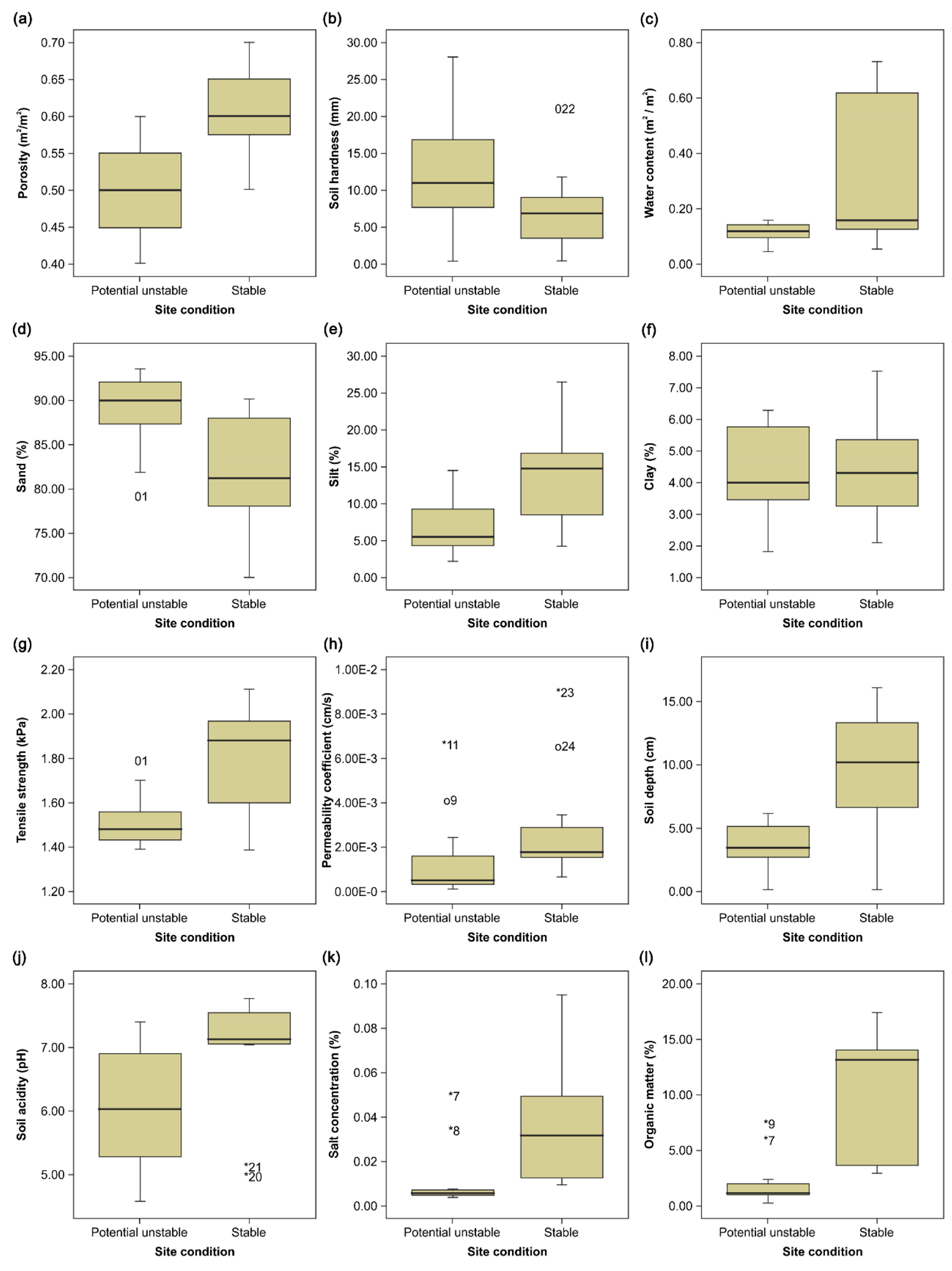
3.3. Soil Properties
The soil porosity of the potential unstable slopes ranged from 0.417 to 0.55 m
3/m
3 (average 0.497 m
3/m
3), and that of the stable slopes ranged from 0.55 to 0.65 m
3/m
3 (average 0.610 m
3/m
3) through the analysis as a disturbed sampling (
Figure 4). Soil hardness of the potential unstable slopes ranged from 5.867 to 16 mm (average 12.667 mm), and that of the stable slopes ranged from 0.833 to 14.6 mm (average 6.933 mm). Hard or compacted soil reduces root length and leaf area [
45,
46]. A previous study argued that if the soil hardness is more than 27 mm, root permeability in various ways is difficult; if it is 24 to 27 mm, root development is badly impacted; if it is 20 to 24 mm, plants may suffer impeded root development; if it is 11 to 20 mm, root development is not disturbed; and if it is less than 11 mm, root development does not have any problems with reduced or dried bearing capacity [
47]. The other previous study reported that the soil hardness of 11 to 23 mm satisfies the standard for an artificial soil required to revegetate a damaged slope; if it is less than 11 mm or more than 27 mm, the standard is not satisfied; and if it is 23 to 27 mm, the standard may not be satisfied because phreatophyte plants may not grow in such soil condition [
36]. All soils have appropriate hardness values for growing plants, as examined in previous studies. The soil water content of the potential unstable slopes ranged from 0.093 to 0.156 m
3/m
3 (average 0.115 m
3/m
3), and that of the stable slopes ranged from 0.061 to 0.689 m
3/m
3 (average 0.327 m
3/m
3).
Soil texture was classified as sand, silt, or clay. The fractions for the potential unstable slopes were: sand 81%–92.63% (average 88.77%); silt 3%–12.77% (average 6.80%); and clay 3.1%–6.23% (average 4.42%). For the stable slopes, sand content was 76.37%–89.10% (average 82.13%); silt was 6.7%–19.63% (average 13.51%); and clay accounted for 2.6%–6.07% (average 4.35%). The Mann-Whitney U-test gave p-values of 0.001 for sand and silt, both of which indicate a significant difference between the groups due to sand and silt soil textures. For clay, the p-value was 0.771, indicating a non-significant difference between the groups. The percentage of sand at the potential unstable sites was higher than that of the stable sites, whereas the percentage of silt at the potential unstable sites was lower than that of the stable sites.
Based on the technique of [
41], the tensile strength of the potential unstable slopes ranged from 1.433 to 1.717 kPa (average 1.519 kPa), compared with 1.537 to 2.043 kPa (average 1.813 kPa) for the stable slopes. The permeability coefficient of the potential unstable slopes ranged from 2.38 × 10
−4 to 3.11 × 10
−3 cm/s (average 1.34 × 10
−3 cm/s), and that of the stable slopes ranged from 1.27 × 10
−3 to 8.23 × 10
−3 cm/s (average 3.06 × 10
−3 cm/s). The soil depth on the potential unstable slopes ranged from 0.2 to 6.2 cm (average 3.58 cm), compared with 0.2 to 16.1 cm (average 9.21 cm) on the stable slopes. In Korea, regarding the spraying measures for revegetation in standard estimation frequently used in constructions, the maximum required soil depth is generally 15 cm [
33]. The required soil depth increases with a steeper slope gradient; as the ground layer is composed of more rocks, the soil depth is also increased [
36]. The soil depth depends on the ground layer and slope angle.
The soil acidity of the potential unstable slopes ranged from pH 4.58 to 7.41 (average 6.07), and that of the stable slopes ranged from pH 5.01 to 7.77 (average 6.89). The salt concentration of the potential unstable slopes was 0.005%–0.039% (average 0.012%), and that of the stable slopes was 0.011%–0.070% (average 0.034%). The soil organic matter content of the potential unstable slopes ranged from 0.55% to 7.00% (average 2.34%), and that of the stable slopes ranged from 2.99% to 16.40% (average 10.41%). Thus, the average soil organic matter content on the potential unstable slopes was less than that on the stable slopes.
Potential unstable slopes had higher average values than stable slopes in the distribution of soil hardness (
Umw = 61;
p < 0.05,
Figure 4b) and sand ratio (
Umw = 35;
p < 0.05,
Figure 4d) whereas they had lower average values in all the other variables: porosity (
Umw = 20;
p < 0.05,
Figure 4a); water content (
Umw = 63;
p < 0.05,
Figure 4c); silt ratio (
Umw = 190;
p < 0.05,
Figure 4e); clay ratio (
Umw = 105.5;
p > 0.05,
Figure 4f); tensile strength (
Umw = 192.5;
p < 0.05,
Figure 4g); permeability coefficient (
Umw = 177;
p < 0.05,
Figure 4h); soil depth (
Umw = 180.5;
p < 0.05,
Figure 4i); soil acidity (
Umw = 171;
p < 0.05,
Figure 4j); salt concentration (
Umw = 196;
p < 0.05,
Figure 4k); and organic matter (
Umw = 209;
p < 0.05,
Figure 4l). In summary, except for the silt ratio, most variables of soil properties were significantly different between the potential unstable slopes and stable slopes.
Figure 4.
Soil properties of potential unstable slopes and stable slopes. (a) Distribution of porosity; (b) Distribution of soil hardness; (c) Distribution of water content; (d) Distribution of sand ratio; (e) Distribution of silt ratio; (f) Distribution of clay ratio; (g) Distribution of tensile strength; (h) Distribution of permeability coefficient; (i) Distribution of soil depth; (j) Distribution of soil acidity; (k) Distribution of salt concentration; (l) Distribution of organic matter.
4. Discussion
4.1. Physical Characteristics
Although most of the study sites were located on steep slopes, the risk of failure was greater on the potential unstable slopes because they were more steeply inclined than the stable slopes. Steep inclination is one of the conditions sufficient to cause failure [
48]. When the slope angle exceeded approximately 35°, a waterway could be installed or a secondary device could be used to prevent soil sliding down when spraying which could serve as a buffer [
49]. In Korea, a physical form of secondary device is typically used when the slope angle exceeds 45° [
33]. This is generally intended to prevent failure of revegetation work when a slope is steep and the ground layer consists of weathered or blasted rock. The secondary devices generally use fiber mesh, wire mesh, and gabion blocks. However, even though the failure slopes were steeply inclined, they did not incorporate a physical secondary device. The failed slopes might be used as an inadequate construction method without sufficient consideration to conduct successful revegetation.
The statistical analysis indicated no significant difference between the potential unstable and stable sites in terms of slope width or height. However, slope width and height are negatively associated with vegetation coverage, which indicates that incomplete vegetation cover increases the risk of slope failure [
50]. Except for site 4, most slope failures resulted from inappropriate maintenance within the recommended two-year span; thus, the reasons for failure were probably factors other than the height and width of the slopes.
The average elapsed time since revegetation was longer for the stable slopes than the potential unstable sites, meaning that elapsed time satisfied several conditions of non-failure. Particularly, as elapsed time increased, the rate of herbaceous species growth decreased and the rate of arboreal species growth increased [
51], as did the vegetation coverage [
22]. Thus, the survival of vegetation could help with slope revegetation [
52]. Consequently, sufficient elapsed time is needed to stabilize the slope after construction.
Due to the small sample size of the present study, the findings on physical characteristics cannot be generalized to indicate an effect of revegetated-slope failure. However, these results can be utilized as reference data for further studies.
4.2. Vegetation Properties
The plant communities differed between the potential unstable and stable sites. Most stable sites showed a landscape that was homogeneous with adjacent environments, and a vegetative form comprising multiple layers. Except for site 3, plant communities at the potential unstable sites were heterogeneous and simple, with very simple vegetation structures.
Vegetation coverage also differed between the potential unstable and stable sites. Except for sites 3 and 4, the potential unstable sites showed vegetation coverage of less than 40%. Fewer arboreal species existed at locations with very low soil porosity, organic matter content, and vegetation coverage. This was assumed to be the result of difficult soil conditions and ground layers for vegetation in the absence of physically based secondary devices.
The trees present at potential unstable sites were mostly small-sized leguminous plants, whereas the stable sites were more diverse, including tall specimens of
Quercus mongolica,
Morus bombycis, and
Ailanthus altissima. The diversity of tall trees positively affected the accumulation of rich organic content derived from the decomposition of leaf and root matter [
38,
53]. Accordingly, the soil organic matter content on the stable sites was higher than at the potential unstable sites.
The most dominant species of herbs were
Artemisia princeps var.
orientalis, followed by
Poa pratensis and
Humulus japonicus. Impatiens textori,
Dendranthema boreale (Makino) Ling
ex Kitam,
Aster yomena, and
Erigeron annuus were also present at five sites. Particularly,
Artemisia princeps var.
orientalis,
Poa pratensis, and
Humulus japonicus were the plants of succession from the surroundings. Domination by
Artemisia princeps var.
orientalis,
Poa pratensis, and
Humulus japonicas interrupts the invasion of other plant species from the surroundings. As a result, natural landscape restoration would not be achieved, or would otherwise require considerable time [
54]. Thus, greater species richness was not always beneficial, and potential dominance by introduced species should be carefully monitored. As shown in site 8, even though five years had elapsed since construction,
Artemisia princeps var.
orientalis still dominated, slowing the ecological succession.
Previous studies also reported the importance of vegetation for preventing slope failure [
5,
55]. Many studies in Mediterranean climates such as in Spain and Italy related to the vegetation variables have focused on the growth of herbs and shrubs [
56,
57]; otherwise, in temperate climates such as in South Korea, China, and Japan attempts were made at introducing tree usage to protect damaged slopes [
1,
5,
58]. However, their studies, regardless of regional areas, found that leguminous, compositae, and graminaceous plants could adapt a revegetated slope well [
6]. This study also showed similar results but we suggested that excessive dominance by a specific species such as
Artemisia princeps var.
orientalis,
Poa pratensis, and
Humulus japonicus should be avoided. The common response of Korean academia has tempted the growth of diverse plants, although it remains a controversial issue of whether the use of diverse plants is important to protect slope failure [
54]. However, since a predominant plant shows a simple layer of plant community, the competitive and symbiotic relationship within ecosystem can be overlooked.
All of the vegetation variables contributed to the difference observed between the potential unstable and stable slopes. Thus, colonization by trees and herbs was assumed to be important for slope stabilization, because the vegetation structure and diverse vegetation communities of the stable slopes mostly comprised multiple layers with high vegetation coverage and a large number of trees and herbs. Thus, the increased number of trees and herbs is preferable for slope stabilization.
Chrysanthemum and leguminous plants dominated the slopes in the investigated area. Particularly, the leguminous plants were symbiotic for nitrogen fixation [
59]. Since nitrogen is very important for plant growth, nitrogen fixation by leguminous plants is beneficial for barren areas. Thus, the high ratio of leguminous plants indicates that sufficient nitrogen was supplied to the slopes to benefit plant growth.
4.3. Soil Properties
Analysis of the soil variables indicated significant differences between potential unstable and stable sites. Among the soil variables, tensile strength increased if porosity and water content were high, soil was deep, sand content was low, and silt content was high. Furthermore, soil tensile strength was directly and inversely related to the failure of revegetated slopes; therefore, if soil tensile strength is low, slope failure could occur. Soil tensile strength of revegetated soil has been studied narrowly even though the tensile strength of natural soil has been studied extensively [
60,
61]. The previous results suggested by Nearing
et al. (1988) [
41] showed the range of 1.0 kPa–3.0 kPa for soil tensile strength [
62,
63]. The results of this study also showed the range of 1.433 kPa–2.043 kPa. According to the results of this study, the minimum tensile strength required for slope stability was more than 1.5 kPa. The tensile strength of potential unstable sites was mostly less than 1.5 kPa, whereas all stable sites achieved more than 1.5 kPa.
According to the thresholds identified between the potential unstable sites and stable sites, the soil porosity required for slope revegetation was at least 0.5 m
3/m
3, and the soil water content was at least 0.12 m
3/m
3. The soil organic matter content required for slope revegetation was at least 3%, and the potential unstable sites were less than 2.5% whereas the stable sites exceeded 3%. Soil with high porosity contains large volumes of soil organic matter, which helps healthy vegetation growth by supplementing the soil’s bearing capacity, whereas soil with low porosity permeates slowly [
38,
64]. Bochet and Garcia-Fayos (2004) [
13] found that around 1.5% of the organic matter of revegetated soils in embanked northern slopes was shown, whereas the vegetation cover rate was approximately 60%. However, since there were gentle slopes of 45° or less and a lower ratio of sand, it might be difficult to compare those results with the results of this study.
Other variables of soil hardness, soil texture, permeability coefficient, soil depth, soil acidity, and salt concentration showed significant differences between the two slope categories; therefore, they could be important for slope stabilization.
Soil hardness did not affect slope stability as much as it affected plant growth. The evaluation standard for “defective” soil hardness, which is less than 11 mm [
36], should be reconsidered because the present study found an average of 6.933 mm for stable sites. Furthermore, a previous study reported that the soil hardness of natural vegetation areas was approximately 5 to 11 mm [
65], which suggests that the standard requires amendment.
The ratios of sand and silt were important for soil texture. If the sand ratio was more than 85% and the silt ratio was less than 10%, slope failure occurred. This could be attributed to the low tensile strength of soils with a high sand content. The soil texture of the potential unstable slopes had the highest percentage of sand while having a lower percentage of silt than the stable sites had. The high percentage of sand means low soil organic matter as well as porosity in the soil [
38].
The permeability coefficient causes drainage problems and results in the poor growth of plant roots if it is over 10
−4 or under 10
−7 cm/s, [
38]. The soil permeability coefficients of most sites were within the range of 10
−2 to 10
−3 cm/s, which did not influence plant growth, and thus it was difficult to establish a direct correlation with slope failure.
Steep slopes require a thick layer of revegetated soil to raise the root length of vegetation. The soil depth was thinner on potential unstable slopes than on the stable slopes. The thin layer of soil cannot be enough to grow plants since the ground layer in a damaged slope has inadequate nutrition.
Neither soil acidity (range pH 4.58 to 7.77) nor salt concentration (less than 0.1%) could illuminate the difference between potential unstable and stable sites. Their ranges did not have harmful effects on of plant growth.
5. Conclusions
The integrated variables were utilized to compare potential unstable sites and stable sites for revegetated slope stability, whereas previous studies used partial variables or focused on the relationships alone. As shown in the previous sections, the variables representing physical characteristics had limitations as indicators of slope stabilization because of the small sample size. However, these samples can be regarded as reference data on revegetated slopes for use in further studies.
Most of the revegetated slopes are steep. Previous studies reported that steep slope angle makes vegetation recruitment difficult. However, in the present study, partial stable sites had multi-layered vegetation with revegetated soil of good condition despite the steep slopes of 45° or more.
All the soil variables were related to slope failure. That is, rather than the environmental condition of the slope, the construction method used for slope revegetation is the cause of the subsequent failure. Thus, the use of high-quality soil would prevent the failure of revegetation. Appropriate soil conditions, combined with slope stability, should encourage vegetation growth and overcome barren environments such as steep slopes, the absence of a drainage system, long width and length of a slope, and chronic exposure to sunlight. The soil condition that overcomes barren environments for a long time can be acknowledged as high-quality soil.
As shown in the non-parametric test results, no significant differences were found for physical characteristics even though previous studies used the variables describing physical characteristics to determine potential slope failure. Specifically, a value of 1.5 kPa is suggested as the new standard for soil tensile strength. However, the investigation of additional cases would allow clearer standards to be established. Furthermore, porosity should be greater than 0.5 m
3/m
3, water content should be greater than 0.12 m
3/m
3, and organic matter should be greater than 3%. The findings also confirmed that the [
36] evaluation standards should be extensively applied.
Soil hardness standards should be partly modified, and other variables should be continuously monitored in relation to plant growth. In addition, except for the number of herbs, the vegetation community, vegetation coverage, and number of trees are factors in slope stabilization. In particular, vegetation coverage is highly correlated with other soil and vegetation variables, making it a major indicator of slope stabilization. Moreover, failure did not occur in revegetated areas that matched the characteristics of the surrounding landscape and that contained a large number of native trees. Therefore, the current herb-oriented strategy for slope revegetation should be reconsidered.
A field survey was conducted of potential unstable sites and stable sites using 23 variables. Non-parametric analysis of the field data identified 15 variables as primary determinants of slope failures. Of these variables, one described physical characteristics (years elapsed since slope revegetation); four described vegetation properties (plant community, vegetation coverage rate, number of trees, and number of herbs); and 10 described soil properties (soil porosity, hardness, water content, sand and silt ratios of soil texture, tensile strength, permeability coefficient, soil depth, pH, salt concentration, and organic matter content). Vegetation and soil variables could be used to determine whether a revegetated slope would be stable in its present state.
Slope revegetation is necessary for restoring the physical, landscape, and ecological functions of a barren site. The structure and function of slope revegetation should be similar to the features of the natural surroundings. Such a form is more likely to facilitate ecologically sound restoration. However, revegetating techniques should be applied to depend on different environments of countries, latitudes, and geomorphological features. For successful ecological restoration, evaluation criteria that provide a more complete ecological stabilization process must be developed. This study did not consider impacts associated with factors such as rainfall or the unpredictable effects of earthquakes. Therefore, additional studies should be conducted on the effects of such factors on slope stability. Future studies may include additional case studies, long-term monitoring, and systematic processes that create a detailed standard for selecting appropriate slope reconstruction and ecological restoration measures and conducting experiments that compare ecological and structural stability.


 ,
, 

